chapter 6 impact of industrial expansion in mundra...
TRANSCRIPT

38
Chapter 6 Impact of Industrial Expansion in Mundra Coast
Overview of Mundra Port/SEZ
The existing Adani port was established in 1998. The Mundra Port currently has multipurpose
terminals, container terminals for ships of varying sizes and nature of cargo, facilities for oil tankers
and port backup facilities such as open storage area, covered godowns, chemical and oil storage tank
farm etc. Support infrastructure, comprises connectivity to national network of railways and roads,
power supply, water supply and other utilities and services.
The proposed WFDP comprises four port clusters - namely West Port, South Port, North Port and
East Port, a Liquefied Natural Gas terminal, two shipyards, three desalination plants, associated
intake and outfall structures, port interconnecting road/link network and other necessary
infrastructure. The landward side of the port is to be made into a multipurpose SEZ. Two mega power
plants, the Tatas’ UMPP(Ultra Mega Power Plant) of 4000 MW capacity and the Adani’s 9900 MW
power plant are under construction. The proposed structures are shown on the map below:

39

40
Usage and Capacity
The estimated ship traffic in these ports is listed below:
Port No of ships per year by 2013 Nature of cargo
West 850 Coal, Steel Scrap, Chemicals, Dry Bulk
South 220 Dry Bulk and Oil
North 150 Automobiles
East 300 Steel Scrap, Dry Bulk
The capacity of the Desalination plant near West port is 300 million litres per day. Nearly 1.5 times the
capacity is discharged into the sea as saline water. Desalination plants of 100 mld, 140 mld capacities
are proposed in future. Also, the effluents from the two mega power plants will be discharged into the
sea.
Ecological significance of the area
Gulf of Kutch is one of the few coastal zones in the world having rich bio-diversity. It comprises of
mangroves, Coral reefs, Mudflats, Seaweeds, Commercial Fishes and several rare marine species.
The mangroves of the gulf are the second largest after the Sunderbans in the mainland of India. Gulf
of Kutch is the only place left along the Indian coast after Gulf of Mannar where live corals occur. In
1982, parts of the Gulf area were declared as a Sanctuary and Marine National Park. Recently,
scientists have discovered patches of live corals near Mundra coast. Thus, the Mundra coast is an
ecologically sensitive zone as it supports vast areas of Mangroves, Corals and associated
ecosystems.
Destruction of any of the above components of the fragile ecology will disrupt the entire ecosystem.
The mangroves help the ecosystem by contributing to the oxygen Budget and in Soil Conservation.
Mangroves and Corals are the nursing grounds for a variety of economically important fishes, exotic
coral fishes and innumerable flora and fauna. The gulf also abounds in more than 210 species of
algae. These algae in combination with corals and mangroves provide a conducive ecosystem for
diverse flora and fauna.
Analysis of the satellite imagery of the Mundra region reveals the following landuse pattern:

41

42
Status of Landuse/cover of Mundra Area(2008) :
Sr.No. Luse/cover Area in Ha. % to Total
1 Agri cropped area 2,588 8.06
2 Fallowlands 2,022 6.30
3 Mangrove 1,493 4.65
4
Mangrove
degraded 604 1.88
5 Prosopis 2,697 8.40
6 Barrenland 2,586 8.05
7 Built-up area 2,634 8.20
8 Mudflats 8,395 26.14
9 Salt pan 137 0.43
10 Waterbody 8,373 26.07
11 Turbid Waterbody 587 1.83
Total: 32,115 100.00
The significance of mangroves in coastal ecosystems is undebatable. The Government of India and
the Ministry of Environment and Forests recognise that mangrove forests are ecologically sensitive
areas and need to be protected and conserved. Mangroves are critical to marine coastal soil
conservation, breeding and nursery grounds for fish, crustaceans and other sea life, as well as vital
habitat for birds and other wildlife. As per estimation, just 100 cu m of mangrove area shelters 54,600
prawns. Kutch district has been declared the most important mangrove areas in the state of Gujarat.
A prominent feature of the Mundra Coast is the vast intertidal zone comprising a network of creeks,
estuaries and mudflats. The intertidal zone is unique and very important because the fishermen can
land their boats in these natural creeks and also keep them there safe from strong winds and
currents. The fisherfolk have complete knowledge of the sea and have been living on the coasts for
ages. They are familiar with the creeks of the area and the intertidal zone is important for their
occupation, economic prosperity and survival of their families. The creeks also form a natural
drainage system which if disturbed might lead to flooding during monsoons.
Scientists have identified vacant sites along the Kutch coast (Zone 3 Mandvi-Jakhau, Zone 1 Bachau
Gandhidham) which could be used for industrial development. Along the northern coast, two lengthy
stretches are available without any ecologically sensitive zones that could be used for future
development of industries. Why use the ecologically sensitive and traditional livelihood supporting
Mundra Coast for Industrial Development when alternative sites are available nearby.

43
People using the Mundra area for traditional livelihood Fishing Communities
The marine fishing settlements are transient
fishing villages, which are inhabited by the fishing
communities for 8-10 months in a year. The
transient villages are on sand dunes or mudflats.
After the fishing season the fishing communities
return back to their formal villages, which are
usually 40 to 50 kilometers away from these
transient villages. Usually, all the fishing
households from a village migrate to a particular
coastal settlement and stay together.
The coastal settlements are mentioned below:
Sr. Harbour Village Taluka No of Families
1. Randh Bhadreshwar Mundra 316
2. Bavdi Kukadsar Mundra 40
3. Juna Shekhadia Mundra 40
4. Luni Luni Mundra 178
5. Vira Vira Anjar 85
6. Bharudiya Bhadreshwar Mundra 30
7. Tragadi Tragdi Mandvi 35
8. Shekhadia Shekhadia Mundra 75
9. Zarapara Zarapara Mundra 101
10. Navinal Kutadi Navinal Mundra 30
11. Veera Pagadiya Sangad and Vandi Anjar 90
More than 1000 families of the Mundra coastal area are involved in fishing. These are fisherfolk who
fish on small boats and on feet. Besides fishing in high seas, about 229 people are involved in direct

44
fish sale; 73 people are involved in net making & repairing; whereas over 5000 women are involved in
processing of fish.
Graziers and Livestock rearers
14 villages in the project area are dominated by Rabaris (a traditional cattle/buffalorearing community
relying entirely on animal husbandry). Gujarat government order (2002) directs that every village has
to have 40 acres of gauchhar land for 100 animals. The total livestock in the 14 villages and the
population dependent on it is shown below
Village Cattle Reqd Gauchar Land(Ha)
Total Gauchar Land (Ha)
Gauchar Land allotted to SEZ(Ha)
Gauchar land Remaining(Ha)
Shortage in Required Gauchar Land %
Navinal 1753 280 137 94 43 85% Tunda 1189 190.24 158 86 72 62% Luni 833 133.28 81 81 0 100% Siracha 3170 507.2 390 41 349 31% Baroi 276 44.16 141 31 110 Goersama 957 153.12 86 29 57 63%
Zarapara 5509 881.44 1000 408 592 33%
Mundra 273 43.68 NA 496 NA Source: Panchayat Records
Old Port related occupations
There are several old Ports in Gujarat at Porbandar, Mandvi and Jamnagar.But the Old Mundra Port
(adjacent to the Adani Port) and run by the Gujarat Maritime Board is the only one that is doing good
business. The trade from Mundra Port includes export of food grains to Somalia, Iraq and other
middle Eastern countries. These ports are small and do not require dredging since there are no ships
used. They use country crafts of capacities varying from 500 to 1500 tonnes which are built locally in
Mandvi. The Maritime board has an income of almost Rs 1 crore from the Old Mundra Port alone.
Project Impacts
Till date
Displacement of fisherfolk
Nearly 35 fisherfolk of Kuthadi Bander near Navinal village who were fishing using the Baradi Mata
and Kotadi Creeks have already been displaced when work started for the construction of intake and
outfall channels for the Power plant and Desalination plant and dredging for the West port.
Other Livelihoods Affected
The fishing communities are only one segment of the affected population. The agriculturists, the
horticulturists (date orchards) and those dependent on animal husbandry have been badly hit as
45
grazing grounds are shrinking. A total of 14 villages have already lost more than 1,400 acres of
grazing land (under panchayats) to the SEZ. Maldharis (livestock rearers) came out strongly against
the company in the November 11 public hearing. Says Vaaljibhai from Jharpara village, where 60% of
the families depend completely on livestock rearing, "We have been protesting against the handover
of 1,000 acres of our gowcher land for the SEZ. We will not let the company set foot on our grazing
lands." On December 22, the village organised a rally in front of the Mundra tehsil office and warned
that they will bring their 8,000-odd cattle and buffaloes into Mundra town and block all the roads if the
notices to their panchayats (about the handover of gowcher lands) are not withdrawn.
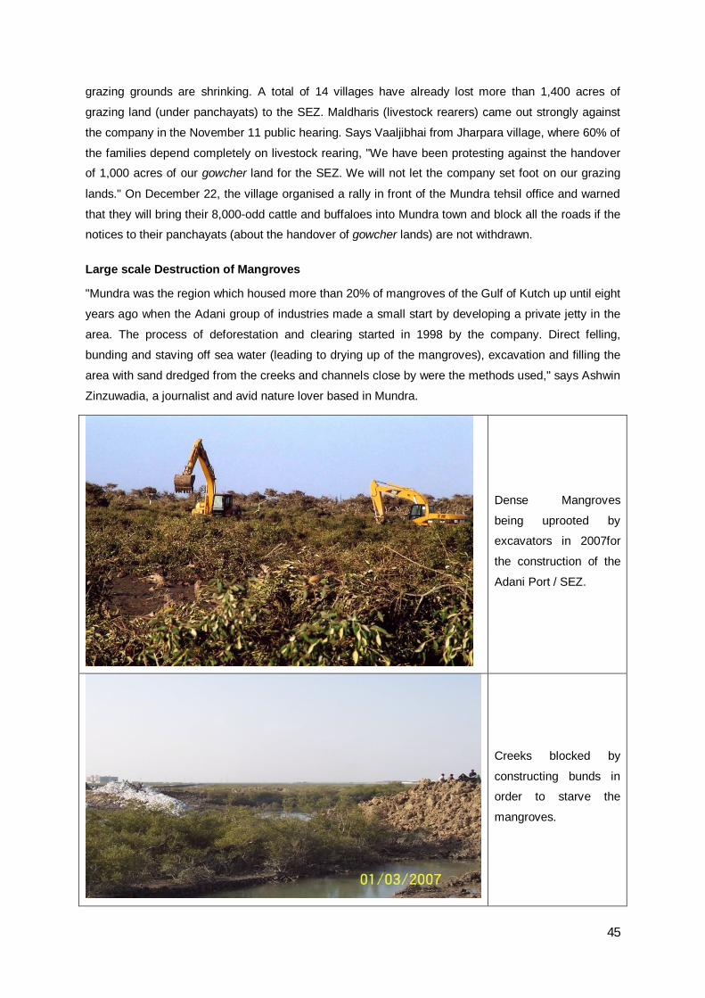
Large scale Destruction of Mangroves
"Mundra was the region which housed more than 20% of mangroves of the Gulf of Kutch up until eight
years ago when the Adani group of industries made a small start by developing a private jetty in the
area. The process of deforestation and clearing started in 1998 by the company. Direct felling,
bunding and staving off sea water (leading to drying up of the mangroves), excavation and filling the
area with sand dredged from the creeks and channels close by were the methods used," says Ashwin
Zinzuwadia, a journalist and avid nature lover based in Mundra.
Dense Mangroves
being uprooted by
excavators in 2007for
the construction of the
Adani Port / SEZ.
Creeks blocked by
constructing bunds in
order to starve the
mangroves.
46
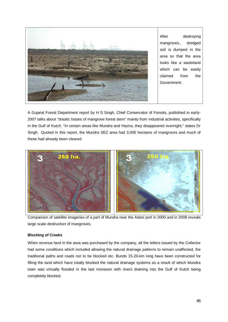
A Gujarat Forest Department report by H S Singh, Chief Conservator of Forests, published in early-
2007 talks about "drastic losses of mangrove forest stem" mainly from industrial activities, specifically
in the Gulf of Kutch. "In certain areas like Mundra and Hazira, they disappeared overnight," states Dr
Singh. Quoted in this report, the Mundra SEZ area had 3,000 hectares of mangroves and much of
these had already been cleared.
Comparison of satellite imageries of a part of Mundra near the Adani port in 2000 and in 2008 reveals
large scale destruction of mangroves.
Blocking of Creeks
When revenue land in the area was purchased by the company, all the letters issued by the Collector
had some conditions which included allowing the natural drainage patterns to remain unaffected, the
traditional paths and roads not to be blocked etc. Bunds 15-20-km long have been constructed for
filling the land which have totally blocked the natural drainage systems as a result of which Mundra
town was virtually flooded in the last monsoon with rivers draining into the Gulf of Kutch being
completely blocked.
After destroying
mangroves., dredged
soil is dumped in the
area so that the area
looks like a wasteland
which can be easily
claimed from the
Government.

47
Water Crisis
The other major issue is the water crisis which is affecting irrigation and drinking water needs. The
company is not only extracting groundwater but is also getting water from the Narmada Canal. In
Kutch, 47.5 million litres per day of water from the Narmada has already been allotted to various
industries including the Adani group.
The company has been speaking of desalination plants since its first Environment Impact Assessment
and not one has been constructed. Instead it has opted for cheaper options to externalise the costs
considering that it has to pay almost Rs 10/ 1,000 litres for the Narmada water. In addition to that, the
company and its subcontractors are taking large quantities of water from tanker suppliers for
construction and other domestic use. All this has already started showing significant negative impact
on the area's groundwater and increase in salinity. Not that the desalination plants of large capacities
would not be harmful. "The salt extracted would be dumped into the nearby seas and creeks making it
impossible for marine fauna to survive," adds Michael Mazgaonkar of Paryavaran Suraksha Samiti,
an environment action group in Gujarat.
Likely future impacts on environment
The WFDP is likely to create serious hazard for the local environment. The Mundra coast has nearly
2000 Ha of Mangroves. The dense mangrove vegetation, which forms a crucial link for marine
ecology is being destroyed for the expansion of the Adani port. Mangroves are also crucial for their
shore-line stabilizing role, serving as a natural wall against ocean currents and cyclones. As this
protection would be removed, the hinter land would be more vulnerable to natural disasters
The salinity of water is likely to increase once the desalination plant is operational. The increase in
salinity would hamper the breeding of prawns leading to loss in income for the traditional fisher-folk. In
Jakhao, the desalination plant setup by Sanghi has been operational since 1998. Before the plant was
started Prawn fishing was widely prevalent in the area. But, the prawn catch declined after the
desalination plant was started and now is virtually non-existent.
Fish merchants are reluctant to buy fish near Kandla port due to the smell of oil that is noticed in the
fish in the area. Now, with the rapid expansion of the Mundra port, is the same situation likely to occur
throughout the Gulf of Kutch.
All the impact assessment studies, which are mandatory for clearances under the CRZ notification,
were initially done for the Adani's Mundra projects by the National Institute of Oceanography. The
concluding statements in all the reports that are quoted in the state government's recommendations
are more or less the same. They all speak of the biodiversity and marine ecology of the area being
critical. They all refer to the localised impacts of the developments, whether port expansion or bulk
terminal construction, on the benthic flora and fauna of the region. But all of them end with the
statement that the "overall impact would be insignificant".

48
A glance at the EIA clearly reveals that there has been little groundwork done by the consultants. The
EIA unjustifiably portrays the project area as barren land the development of which would therefore
lack significant environmental impacts. The image from Google maps apparently reveals a vast area
of natural marine ecology that would be dredged or filled under the project proposal. It is highly
misleading to characterise this land as wasteland. The shallow waters and tidal mud flats that
comprise this vast undisturbed area play a vital role in the overall ecology of the area even if they are
not heavily vegetated," claims Mark Chernaik, a technical expert of the E-Law Network, who carried
out a critical analysis of the EIA report.
Likely impact on livelihoods More than 1,000 fishing families of the area have been suffering as a result of the Adani group's
activities in the region. These are fisherfolk who fish on small boats and on foot. "Besides fishing in
high seas, about 229 people are involved in direct vending; 73 people are involved in net making and
repairing; whereas about 1,037 people are involved in processing of fish. It is almost a Rs 100 crore
economy," states a report prepared by SETU and Yusuf Meherally Centre. The port and SEZ-related
construction have been blocking their traditional fishing routes apart from completely destroying their
traditional fishing creeks and harbours.
Affected people
• Nearly 10000 fisherfolk
• 1015 Muslim Wagher families

49
• 452 Motorized boats used by fisherfolk to venture short distances of about 10 km in to the sea.
• Nearly 1000 Pagadiya families who go by walk into the intertidal zone for fishing.
• Also Grazers and Farmers in nearby villages
Real and hard-hitting questions were raised by the local people on the day of the hearing in Nov,
2008. While they were shocked that the EIA says that the proposed project area has no habitation
and does not involve any kind of rehabilitation or resettlement issues, what really surprised them is
that the government, after a decade of the
company's expansion, asked for a public
hearing to take place. "What is the point of this
now, after everything is almost over? They
have destroyed the place and are now asking
our opinion," said many of the fishermen from
the affected villages. A visit to the proposed
area for the West Port of the Water Front Plan
in 2008 revealed that construction work had
been full swing for over 6 months – a complete
violation of the Environment Impact
Assessment Notification (2006) which
disallows any activity till the Environment
Clearance is granted by the Union Ministry.
(above) Construction of West Port prior to Environmental clearance seen in Satellite image of
December 2008. Environmental clearance was granted in January 2009 and Final Forest clearance is
still pending.
In February 2009, the fisherfolk approached the NEAA (National Environment Appellate Authority)
and appealed that clearance be rejected for the Adani Port expansion project (Water front
development project). In its verdict the NEAA declined to reject the clearance, but acknowledging the
fisherfolk issues as genuine, the NEAA directed the state government to ensure unhindered fishing in
the Mundra area. Regarding the environmental violations the fisherfolk were given the liberty to
approach the statutory bodies, namely the MoEF authorities.
In a presentation before the Hon. Minister for Environment and Forests during the CMZ consultations
in Mumbai on August 12th, Mr.Bharat Patel, the general secretary of MASS (Machimar Adhikar
Sangharsh Sangathan) highlighted the issues of the fisherfolk, the mangrove destruction and the
violation of environmental laws by the Adanis. Shocked at the 2007 photographs of mangroves being
indiscriminately cleared by use of excavators, Shri.Jairam Ramesh has assured in public that a
committee would soon be sent to investigate the Mundra Issue.

50
Demands of Fisherfolk
1. The Bander land should be allotted to fisherfolk and the bander should be declared as a
fishing zone.
2. 5-7 km wide and 4 km long stretch of Intertidal zone in front of each Bander should be meant
for fishing only and not used for any industrial development.
3. The access road from main road to the Bander should not be blocked
4. Creeks in the Mundra Coast should not be filled or blocked as they are used by fisherfolk to
navigate to fishing grounds.
5. The sea routes to the fishing grounds should not be obstructed by ships anchored on the
routes to the port
6. Hazardous wastes and oil should not be dumped near the coast. Highly Saline discharge from
desalination plants can be treated and used for salt extraction, but should not be disposed in
the sea near the shore as it will affect fishing. No Desalination plant or shipyard should be
allowed near the fishing enclaves
7. Destruction of Mangroves near the Mundra Coast should be stopped as mangroves are
crucial for fishing livelihood.
In short, Further expansion of the Adani Port - Waterfront Development project should be stopped.
References
[1] EIA Report of Waterfront Development Project (Draft Rapid Environment Impact
Statement & EMP AND Draft Risk Assessment & DMP OF WATER FRONT DEVELOPMENT PLAN
Mundra Port & SEZ Ltd.) 2008
[2] Marine EIA of the Waterfront Development Plan (WFDP) of Mundra Port, Dist. Kachchh, Gujarat.
2008
[3] Geographical Information System for Gulf of Kachchh, Department of Ocean Development,
Integrated Coastal and Marine Area Management (ICMAM) project Directorate, Chennai, 2002
[4] How Mundra became India's Rotterdam By Manshi Asher published in InfoIndiaChange on 27th
December, 2008.
[5] Implication of SEZ, A study conducted by Setu Bhadreshwar, Ujjas Mahila Sanghatan and Yusuf
Meherally Centre in 2005.