chapter 6 arsenal street corridor study: recommendations
TRANSCRIPT

207 Recommendations
6Recommendations
Chapters 4 and 5 developed, screened, and analyzed potential transportation and
mobility improvements for the Arsenal Street corridor. The alternatives analysis was
combined with input from a variety of stakeholders including the Working Group,
Town of Watertown, MassDOT, the MBTA, and the public (residents, employers, and
workers). These efforts resulted in the identification of recommended improvement
projects to be considered for implementation. This chapter presents an “Action Plan”
for implementation of the study recommendations.
OverviewThe study took a multimodal approach to transportation infrastructure needs and
recommends a program of short-term actions (1 to 5 years), medium-term actions
(5 to 10 years), and long-term actions (over 10 years). Immediate recommendations
(under 1 year) were presented in Chapter 4 and consist of RSAs, traffic signal
deficiency/compliance, and curb ramp improvements.
Improved mobility and safety were the primary drivers that guided the development
of the recommended Action Plan. This study does not identify specific funding sources
for each recommendation because of the many variables and the uncertainty
associated with funding sources and schedules for projects. While funding is always a
consideration and was factored into the evaluation criteria, funding availability was not
a primary driver for the development of the study recommendations.
It is acknowledged that the recommendations presented herein represent a
significant investment in potential transportation-related infrastructure. These projects
represent an investment in total that currently far exceeds available funding as
presently programmed. The advancement of the recommendations developed as part
of this study will require prioritization by (and coordination between) the Town of
Watertown, MBTA, MassDOT, and other stakeholders to address current fiscal
constraints as related to transportation improvements. Besides prioritization,

208 Recommendations
identification of potential funding sources and availability to leverage funding could
alter priorities.
Recommended Action PlanTable 6-1 presents the details of this Action Plan, including construction cost
estimates, potential funding sources, the responsible facilitating organizations, the
implementation timeframe, and specific next steps. Figure 6-1 presents an overview of
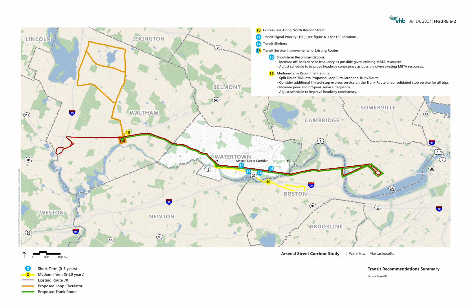
the recommended non-transit projects that comprise the Action Plan. Figure 6-2
focuses specifically on transit recommendations.
Each of the projects will need to follow a multi-step process as shown below.
Depending on the project, some of the early steps may have already been completed
either as part of this study or in other studies.
Step 1: Problem/Need/Opportunity Identification
Step 2: Project Planning
Step 3: Project Initiation
Step 4: Environmental Review and Permitting /Design/Right-of-way
Acquisition
Step 5: Funding/Programming on the Regional and State Transportation
Improvement Programs
Step 6: Advertise/Bid and Contract Award
Step 7: Construction
As noted in Table 6-1, some recommendations are not anticipated to require
environmental review and permitting. More complex recommendations, such as
Soldiers Field Road Gateway Improvements and Watertown Square Gateway
Improvements, will likely require more in-depth design, permitting, and
environmental documentation. These initial steps would begin in the immediate- or
short-term timeframes. Right-of-way acquisition is anticipated for some of the
recommendations, as noted in Table 6-1.
The town’s bicycle network continues to evolve and will become more robust with
plans for connections between Arsenal Street and Saltonstall Park and for an extension
of the Watertown Greenway to the existing Fresh Pond trail system. The
recommendations of this study should be coordinated, with respect to timing and
scope, with these and other ongoing initiatives to develop a comprehensive bicycle
network. For example, Bicycle Lanes East of School Street should be coordinated
with the planned bicycle accommodations to the west being advanced by
athenahealth. Similarly, Cross Connectivity between the Greenway and Charles

209 Recommendations
River should be coordinated to connect with the Arsenal Street bicycle
accommodations and could evolve to interface more directly with the Hanover/Elan
Union Market east-west pathway to improve connectivity between the river and the
neighborhoods north of Arsenal Street.
As noted in Chapter 4, along with supporting appendix materials, there are several
immediate safety and operational improvements that could be implemented along the
corridor, as well as accessibility improvements that could be made to existing curb
ramps throughout the corridor. These improvements fall solely under the jurisdiction
of the town and do not require coordination with other agencies or jurisdictions. Most
of these improvements could be completed as part of regular intersection
maintenance and should be progressed as quickly as possible. Changes to curb ramps,
which in some cases require reconstruction of the entire ramp, should be planned and
programmed over the next year.
Funding Sources
Although not an exhaustive list, Table 6-1 provides possible funding sources for each
of the alternatives recommended. The funding sources noted were chosen based on
the anticipated size, scope, and cost of a particular project. It was assumed the town
would consider state and/or federal funding assistance for higher cost projects. In
these cases, the town is generally responsible for any permitting and design
associated with the improvement and the state provides funding for certain
construction elements. Town and private developer funds can come from a variety of
sources and were not specifically delineated for the purposes of the Recommended
Action Plan. Three state funding sources were identified. It should be noted that
Chapter 90 funding (discussed below) may also be used discretionally by the town to
cover project design costs.
Complete Streets Funding –The state currently offers up to $400,000 of
construction finding per year to eligible communities to implement Complete
Streets infrastructure elements. These can include enhancements or dedicated
accommodations for bicycle, pedestrian, and transit use, upgrading existing
infrastructure to meet current ADA standards, and constructing “missing links”
in roadway infrastructure that would improve access for non-automobile
users. To be eligible for funding, the town must have a MassDOT approved
Complete Streets policy and prioritization plan. Additional information on this
funding source can be found at http://mass.gov/massdot/completestreets.
Chapter 90 Funding - The state currently provides reimbursement funding
for projects that create or extend the life of capital facilities under Section 34
of Massachusetts General Law (MGL) Chapter 90. Within all applicable
allowances, municipalities have discretion on how the funding can be used.
The funding amount allocated is based on the municipality’s accepted road
miles, population, and employment. For the fiscal year 2017, Watertown

210 Recommendations
received $742,636 of Chapter 90 funds to cover 72 lane miles. This is on par
with allocations from previous years. Additional information on this funding
source can be found at http://mass.gov/massdot/chapter90.
Transportation Improvement Plan Funding – Each Metropolitan Planning
Organization (MPO) within the state has a rolling, five-year capital funding
program. Eligible transportation projects can receive federal and state
roadway funding if the project is selected by the MPO. Selection is based on
an evaluation and prioritization of all eligible projects and includes municipal
and public feedback. Additional information on this funding source can be
found at http://ctps.org/tip-dev.

211 Recommendations
•
Table 6-1 Recommended Action Plan – Commitment Matrix and Implementation Timeframe
Facilitating Organizations Implementation Timeframe (Years) Next Steps
Alternative Construction Cost 1 Possible Funding Source(s) Ma
ssDO
T
MBTA
DCR
Town
of
Wat
erto
wn
EEA
Short-Term Medium-Term Long-Term
Next Steps Responsible Party Notes 1 2 3 4 5 6 7 8 9 10 10+
1. Bicycle Lanes east of School Street
$75,000 to $2,100,0002
• State Complete Streets • State Chapter 90 • Private developer
X X Advance to final design. Seek funding source(s). Town
No environmental review/perming anticipated. Preferable to coordinate with athenahealth bike lanes.
3. Cross Connectivity between the Greenway and Charles River
Variable • Paths being advanced by
others • Town funds for shared lane
markings X X
Support path development by others. Determine support for Complete Streets elements on neighborhood streets.
Town No environmental review/perming anticipated. May be required if formal crossings of Charles River Road are developed
6. Soldier's Field Road Gateway Improvements
$1,500,000 to $2,500,000
• Town funds • Private developer • State Transportation
Improvement Program X X X X
Permitting and Design Construction Advance design. Stakeholder outreach. Research permitting requirements.
Town ROW acquisition anticipated. Will require additional public and stakeholder outreach.
7. Watertown Square Gateway Improvements
$950,000 to $1,500,0003
• Town funds • Private developer • State Transportation
Improvement Program X X X X X
Permitting and Design Construction
Advance design. Engage DCR. Study Charles River Road cut-through traffic impacts.
Town ROW acquisition anticipated. Will require additional public and stakeholder outreach.
10. North Beacon Street Express Bus Variable
• Area stakeholders • MBTA • TMA
X X Pilot Program Full
Service Establish pilot program. Town/MBTA Potential ROW acquisition for transit stops.
11. Transit Signal Priority $250,000 + Upgrades4
• Town funds • Private Developer X X
Advance system design. Coordinate bus stop modifications. Identify signal upgrades.
Town/MBTA ROW acquisition or easements anticipated for relocation of bus stops.
14. Transit Shelters $30,000/ location
• Town funds • Private Developer • MBTA
X X Determine installation & maintenance responsibility. Initiate easement process.
Town/MBTA All locations require small easements from property owners (ROW acquisition).
15. Transit Service Improvements to Existing Routes
$3,600,0005 MBTA X X
With Existing Fleet With Expanded Fleet Further analyze and refine as part of the MBTA’s bus serviceplanning process and bus improvement plan initiative.
MBTA
Alternative 15 cost estimates are intended solely for purposes of comparing alternatives within the context of this study and are not for budgeting purposes. Capital and operating costs will depend on the allocation of MBTA resources across all system routes based on systemwide priorities.
17. Adaptive Signal Control
$250,000 to $500,0004,6
• Town funds • Private Developer X X
Planning/ Implementation Refinement/Upgrades Maintenance
Advance system design. Identify signal upgrades. Further evaluate Watertown Square operations.
Town
1 Construction cost estimates in 2017 dollars. Estimates do not include survey, design fees, right-of-way (ROW) acquisition, permitting, drainage improvements, or utility modifications (if necessary). 2 Lower cost estimate includes removal of paint markings and restriping only. Higher cost estimate includes cold plane/overlay in addition to restriping. 3 Costs may be increased by signal system upgrades/modifications, hardscape/ landscape design, pedestrian lighting, site furnishings. 4 New traffic signal cabinet assembly may be required at some locations. The cost of a new assembly is approximately $40,000 per location. If the intersection is recommended for both transit signal priority and adaptive signal control, this cost is incurred only once. 5 Estimate includes capital cost only for additional vehicles anticipated for medium-term recommendations, and excludes capital costs associated with expanded fleet storage and maintenance facilities. Incremental operating costs are estimated at $200,000 and $800,000 per year for short-term and medium-term recommendations, respectively. 6 Ultimate cost will be dependent on type of communication and server chosen.
MassDOT - Massachusetts Department of Transportation, MBTA - Massachusetts Bay Transportation Authority, DCR - Department of Conservation and Recreation, EEA - Executive Office of Energy and Environmental Affairs Information on state funding sources can be found at the following locations: Complete Streets (mass.gov/massdot/completestreets), Chapter 90 (mass.gov/massdot/chapter90), State Transportation Improvement Program (ctps.org/tip-dev)

Arsenal Street Corridor Study Watertown, Massachusetts
FIGURE 3-1
Traffic Analysis Zone MapSource: MassGIS
0 325 650162.5 Feet
Apr 03, 2017\\
vhb\
proj
\Wat
-TS\
1329
0.00
Ars
enal
St C
orrid
or\G
IS\P
roje
ct\S
tudy
_rec
omm
enda
tions
.mxd
X
7
X
11 17/ 17
3
11 17/3
11
17/
33
11 17/11 17/ 11 17/
1
11 17/ 11 17/3
17
3
6
X
\\vh
b\pr
oj\W
at-T
S\13
290.
00 Ar
sena
l St C
orrid
or\g
raph
ics\F
IGUR
ES\1
1x17
form
at.in
ddApr 17, 2017
Arsenal Street Corridor Study Watertown, MassachusettsNot to scale
FIGURE 6-1
Study RecommendationsSource: MassGIS
Short-Term (0-5 years)Medium-Term (5-10 years)Long-Term (10+ years)By Others
Arsenal Street Corridor Study Watertown, Massachusetts
FIGURE 3-1
Traffic Analysis Zone MapSource: MassGIS
0 325 650162.5 Feet
Apr 03, 2017\\
vhb\
proj
\Wat
-TS\
1329
0.00
Arse
nalS
tCor
ridor
\GIS
\Pro
ject
\Stu
dy_r
ecom
men
datio
ns.m
xd
Note: Funding availability (ie. State Transportation Improvement Program)
may impact assumed recommendation time frames.
To Boston Landing
WatertownYard
Charles River
WhitneyHill Park
Arsenal Mall
Watertown Mall
WatertownSquare
IRVING STREET
PATTEN STREET
TAYLOR STREET
BEECHWOOD AVENUE
TALCOTT AVENUE
LOUISE STREET
ARLINGTON STREET
IRVI
NG S
TREE
T
GALEN STREET
WATERTOWN
20
20
BAY STREET
ALFR
EDRO
AD
BIRCH ROAD
OAK STREET
CALV
INRO
AD
COMMON STREET
MAPLE STREET
UPLAND ROAD
BAILEY ROAD
OLIVERSTREET
FAYETTE STREET
AMHERST ROAD
NICHOLS AVENUE
ARDEN ROADHILL
STREET
BATE
SRO
AD
IRMA AVENUE
LLOYD ROAD
WHEELER
LANE
GROVE STREETTH
URST
ON R
OAD
RICHARDS ROAD
PARKER STREET
WELLS AVENUE
FIFIELD STREET
OAKLEY ROAD
HILL
SIDE
ROA
D
BOYLSTONSTR EET
MARION
ROAD
WILLIAMS STREET
WATER STREET
PALMER STREET
PRIE
ST R
OAD
ADAM
SAV
ENUE
CENTER STREET
FRANK STREET
LAUREL STREET
ARSENAL STREETWOOLEY AVENUE
OTIS STREET
MARSHALL STREET
COOLIDGE HILL ROAD
BARN
ARD
AVEN
UE
ROBB
INS
ROAD
PALFREY STREET
KIMBALL ROAD
STONELEIGH CIRCLE
BIGELOW AVENUEEL
TON
AVEN
UE
PORTER STREET
QUIMBY STREET
PUTNAM STREET
CHESTER STREET
LINCOLN STREETW
INSO
RAV
ENUE
SCHO
OL S
TREE
T
HUNT STREET
WALNUT STREET
LANG
DON
AVEN
UE
FAIRFIELD STREET
PAUL STREET
DARTMOUTH STREETCONCORD ROAD
MEL
ENDY
AVEN
UE
RUSS
ELL A
VENU
E
FRANKLIN STREET
CYPRESS STREET
GARFIELD STREET
ARSENAL STREET
CRAWFORD STREET
ARSENALMARKETPLACE
BIRMINGHAM PARKWAY
SOLDIERS FIELD ROADCHARLES RIVER ROAD
SPRUCE STREET
NONANTUM ROAD
GREENOUGH BOULEVARD
16
16
16
16
Arsenal Street Corridor Study Watertown, Massachusetts
FIGURE 3-1
Traffic Analysis Zone MapSource: MassGIS
0 325 650162.5 Feet
Apr 03, 2017\\
vhb\
proj
\Wat
-TS\
1329
0.00
Ars
enal
St C
orrid
or\G
IS\P
roje
ct\S
tudy
_rec
omm
enda
tions
.mxd
Bike Lanes East of School Street
Cross Connectivity between the Greenway and Charles River
Soldiers Field Road Gateway Improvement
Watertown Square Gateway Improvement*
Express Bus along North Beacon Street (see figure 6-2)
Transit Signal Priority (TSP)
Transit Shelters (see figure 6-2)
Transit Service Improvements to Existing Routes (see figure 6-2)
Adaptive Signal Control (ASC)
1
3
7
10
11
14
17
6
15
Watertown Greenway
WALTHAMSOMERVILLE
NEWTON
CAMBRIDGE
ARLINGTON
LEXINGTON
BOSTON
MALDEN
WESTON
BROOKLINE
BELMONT
MEDFORD
WATERTOWN
EVERETT
LINCOLN
1
20
3
20
95
93
90
95
90
90
60
2A
16
28
30
2A
117
16
2
38
9
3
28
16
30
30
60
99
2
Arsenal Street Corridor Study Watertown, Massachusetts
FIGURE 1
Transit Recommendation Summary
Source: MassGIS
0 2000 40001000 Feet
Apr 17, 2017\\
vhb\
proj
\Wat
-TS\
1329
0.00
Ars
enal
St C
orrid
or\G
IS\P
roje
ct\T
rans
it_Re
com
men
datio
ns.m
xd
Existing Route 70Proposed Loop Circulator
_10
Proposed Truck Route
Short-term Recommendations:
- Install bus shelters at select locations.- Increase off-peak service frequency.- Adjust schedule for targeted trips.
Medium-term Recommendations:
- Split Route 70A into proposed loop circulator and truck route.- Add truck route express service.- Increase peak and off-peak service frequency- Adjust schedule for targeted trips.
WALTHAMSOMERVILLE
NEWTON
CAMBRIDGE
ARLINGTON
LEXINGTON
BOSTON
MALDEN
WESTON
BROOKLINE
BELMONT
MEDFORD
WATERTOWN
EVERETT
LINCOLN
1
20
3
20
95
93
90
95
90
90
60
2A
16
28
30
2A
117
16
2
38
9
3
28
16
30
30
60
99
2
Arsenal Street Corridor Study Watertown, Massachusetts
FIGURE 1
Transit Recommendation Summary
Source: MassGIS
0 2000 40001000 Feet
Apr 17, 2017\\
vhb\
proj
\Wat
-TS\
1329
0.00
Arse
nalS
tCor
ridor
\GIS
\Pro
ject
\Tra
nsit_
Reco
mm
enda
tions
.mxd
Existing Route 70Proposed Loop Circulator
_10
Proposed Truck Route
Short-term Recommendations:
- Install bus shelters at select locations.- Increase off-peak service frequency.- Adjust schedule for targeted trips.
Medium-term Recommendations:
- Split Route 70A into proposed loop circulator and truck route.- Add truck route express service.- Increase peak and off-peak service frequency- Adjust schedule for targeted trips.
XX
1414 14
14
\\vh
b\pr
oj\W
at-T
S\13
290.
00 Ar
sena
l St C
orrid
or\g
raph
ics\F
IGUR
ES\1
1x17
form
at.in
ddJul 14, 2017
Arsenal Street Corridor Study Watertown, MassachusettsNot to scale
FIGURE 6-2
Transit Recommendations SummarySource: MassGIS
Short-Term (0-5 years)Medium-Term (5-10 years)Existing Route 70Proposed Loop Circulator Proposed Trunk Route
WALTHAMSOMERVILLE
NEWTON
CAMBRIDGE
ARLINGTON
LEXINGTON
BOSTON
MALDEN
WESTON
BROOKLINE
BELMONT
MEDFORD
WATERTOWN
EVERETT
LINCOLN
1
20
3
20
95
93
90
95
90
90
60
2A
16
28
30
2A
117
16
2
38
9
3
28
16
30
30
60
99
2
Arsenal Street Corridor Study Watertown, Massachusetts
FIGURE 1
Transit Recommendation Summary
Source: MassGIS
0 2000 40001000 Feet
Apr 17, 2017\\
vhb\
proj
\Wat
-TS\
1329
0.00
Arse
nalS
tCor
ridor
\GIS
\Pro
ject
\Tra
nsit_
Reco
mm
enda
tions
.mxd
Existing Route 70Proposed Loop Circulator
_10
Proposed Truck Route
Short-term Recommendations:
- Install bus shelters at select locations.- Increase off-peak service frequency.- Adjust schedule for targeted trips.
Medium-term Recommendations:
- Split Route 70A into proposed loop circulator and truck route.- Add truck route express service.- Increase peak and off-peak service frequency- Adjust schedule for targeted trips.
Express Bus Along North Beacon Street
Transit Signal Priority (TSP) (see figure 6-1 for TSP locations )
Transit Shelters
Transit Service Improvements to Existing Routes
Short-term Recommendations: - Increase off-peak service frequency as possible given existing MBTA resources.- Adjust schedule to improve headway consistency as possible given existing MBTA resources.
Medium-term Recommendations: - Split Route 70A into Proposed Loop Circulator and Trunk Route.- Consider additional limited-stop express service on the Trunk Route or consolidated stop service for all trips.- Increase peak and off-peak service frequency.- Adjust schedule to improve headway consistency.
10
11
15
15
14
15
10
15
Arsenal Street Corridor