chapter 56. village of lincolnwood annex · pdf filechapter 56. village of lincolnwood annex...
TRANSCRIPT

56-1
CHAPTER 56. VILLAGE OF LINCOLNWOOD ANNEX
56.1 HAZARD MITIGATION PLAN POINT OF CONTACT
Primary Point of Contact Alternate Point of Contact
Mike Hansen, Fire Chief
6900 Lincoln Ave
Lincolnwood, IL 60712
Telephone: 847-673-1545
Email Address: [email protected]
Jim Barnett, Lieutenant
6900 Lincoln Ave
Lincolnwood, IL 60712
Telephone: 847-673-1545
Email Address: [email protected]
56.2 JURISDICTION PROFILE
The following is a summary of key information about the jurisdiction and its history:
• Date of Incorporation: 1912
• Current Population: 12,590 as of 2010
• Population Growth: After the 2010 Census was conducted, Lincolnwood’s population had
increased by 231 residents
• Location and Description: The Village of Lincolnwood is a suburb of Chicago in Cook
County, located 14 miles north of the Chicago Loop. Lincolnwood borders Chicago to the
south and east, Skokie to the north, and Niles to the west. According to the U.S. Census
Bureau, Lincolnwood has a total land area of 2.69 square miles. Lincolnwood is divided or
surrounded by 7 major streets and the Edens Expressway. While primarily a bedroom
community, Lincolnwood does have a small industrial area, a number of small shopping
districts along the main thoroughfares, and an enclosed mall of approximately 100 stores with
two anchor stores.
• Brief History: Potawatomi originally settled the wooded area that made up what is now
Lincolnwood, but vacated the land after the Indian Boundary Treaty of 1816. Rural
development proceeded slowly on treacherous plank roads along present-day Milwaukee and
Lincoln Avenues. Johann Tess, for whom the village was originally named, and his family
came from Germany in 1856, purchasing 30 acres of barren land in the area. Population
slowly increased, and the first commercial establishment, the Halfway House Saloon, was
established in 1873. The agrarian population grew after the establishment of a Chicago &
North Western Railway station in nearby Skokie in 1891 and the completion of the North
Shore Channel in 1909, which made the easily flooded prairie land manageable. More
saloons and taverns soon appeared, specifically along Crawford and Lincoln Avenues.
Because only organized municipalities could grant liquor licenses, 359 residents incorporated
in 1911 and named the village Tessville. Tessville annexed land throughout the 1920s, finally
stretching to Central Avenue on the west and Kedzie Avenue on the east. During Prohibition,
Tessville became a haven for speakeasies and gambling facilities. Tessville was long reputed
for drinking and gambling until the 1931 election of its longest-serving mayor, Henry A.
Proesel, a grandson of George Proesel, one of the original American settlers. In 1932, Lincoln
Avenue, formerly a plank toll road, became a state highway. Proesel then worked with the
federal government’s Public Works Administration and hired the community’s entire

Cook County Multi-Jurisdictional Hazard Mitigation Plan; Volume 2: Planning Partner Annexes
56-2
unemployed workforce to plant 10,000 elm trees on the village streets. Most important, the
community passed a liquor license law (1934) that limited the number of licenses allowable
within the city limits and became a model ordinance for other communities. Proesel finally
changed Tessville’s image when he renamed the village Lincolnwood in 1936. In 1997,
Lincolnwood became a Home Ruled village.
• Climate: The climate of Lincolnwood and the Chicago area is classified as humid
continental, with all four seasons distinctly represented: wet springs; hot and humid summers;
pleasant autumns; and cold winters. Annual precipitation is average, and reaches its lowest
points in the months of January and February, and peaks in the months of May and June.
Winter proves quite variable. Seasonal snowfall in the Village has ranged from 9 – 90 inches.
The daily average temperature in January at Midway Airport is 24.8 °F (−4.0 °C), and
temperatures often stay below freezing for several consecutive days or even weeks in January
and February. Temperatures drop to or below 0 °F (−18 °C) on 5.5 nights annually at Midway
and 8.2 nights at O’Hare. Spring in the Chicago area is perhaps the areas wettest and
unpredictable season. Winter like conditions can persist well into April and even occasionally
into May. Thunderstorms are especially prevalent in the spring time as the areas lakeside
location makes it a center of conflicts between large volumes of warmer and colder air,
triggering many kinds of severe weather. Temperatures vary tremendously in the springtime;
March is the month with the greatest span between the record highs and lows. On a typical
summer day, humidity is usually moderately high and temperatures ordinarily reach
anywhere between 78 and 92 °F (26 and 33 °C). The extreme heat that the Chicago area is
capable of experiencing during the height of the summer season can persist into the autumn
season. Temperatures have reached 100 degrees high and subzero lows below −18 °C. Fall
can bring heavy thunderstorms, many of which are capable of producing flooding. The
average first accumulating snow occurs around Nov 19.
• Governing Body Format: The Village of Lincolnwood operates under a form of government
consisting of an elected Village President, Board of six Trustees, and a Village Clerk. The
Village appoints a professional Village Manager to serve as the Chief Administrative Officer
and oversee the day-to-day operations. The Village of Lincolnwood will assume the
responsibility for the adoption and implementation of this plan. Lincolnwood operates seven
departments: Administration, Police, Fire, Public Works, Parks and Recreation, Community
Development and Finance.
• Development Trends: Lincolnwood is anxiously anticipating the development of the Purple
Hotel site to bring in other commercial and residential developments. There has been a
moderate increase in residential as well as commercial developments already.
56.3 CAPABILITY ASSESSMENT
The assessment of the jurisdiction’s legal and regulatory capabilities is presented in Table 56-1. The
assessment of the jurisdiction’s fiscal capabilities is presented in Table 56-2. The assessment of the
jurisdiction’s administrative and technical capabilities is presented in Table 56-3. Information on the
community’s National Flood Insurance Program (NFIP) compliance is presented in Table 56-4.
Classifications under various community mitigation programs are presented in Table 56-5.

VILLAGE OF LINCOLNWOOD ANNEX
56-3
TABLE 56-1. LEGAL AND REGULATORY CAPABILITY
Local
Authority
State or
Federal
Prohibitions
Other
Jurisdictional
Authority
State
Mandated Comments
Codes, Ordinances & Requirements
Building Code Yes No No Yes Municipal Code adopted: 2009
IBC Code Set
Zonings Yes No No Yes (65 ILCS 5/) Illinois Municipal
Code.
Chapter 15 – Village Zoning
Ordinance adopted: 2008
Subdivisions Yes No No No Chapter 16 Subdivision
Regulations
adopted: 2002
Stormwater Management Yes No Yes Yes State regulates industrial activity
from Construction sites 1 acre or
larger under section 402 CWA.
MWRD Ordinance
Post Disaster Recovery No No No No
Real Estate Disclosure Yes No Yes Yes (765 ILCS 77/) Residential Real
Property Disclosure Act.
Growth Management Yes No No No Municipal Code adopted: N/A
Site Plan Review Yes No Yes No Illinois Department of
Transportation
Municipal Code adopted: 2008
IBC Code Set
Public Health and Safety No No Yes No Cook County Board of Health for
Restaurant Inspections
Environmental Protection No No No No
Planning Documents
General or Comprehensive
Plan
Yes No No No Lincolnwood Comprehensive Plan
– 11-1-2001
Is the plan equipped to provide linkage to this mitigation plan? Yes – Land Use
Yes – Natural Resources
Yes – Redevelopment
Floodplain or Basin Plan No No No No
Stormwater Plan No No Yes No Regional storm water impacts are
governed by MWRD. The Village
lies within the North Branch of
Chicago River watershed planning
area of MWRD’s comprehensive
Stormwater Master Planning
Program

Cook County Multi-Jurisdictional Hazard Mitigation Plan; Volume 2: Planning Partner Annexes
56-4
TABLE 56-1. LEGAL AND REGULATORY CAPABILITY
Local
Authority
State or
Federal
Prohibitions
Other
Jurisdictional
Authority
State
Mandated Comments
Capital Improvement Plan Yes No No No The Village CIP is reviewed
annually but encompasses 5-7
years of anticipated purchases.
What types of capital facilities does the plan address? Roads, Public Buildings
How often is the plan revised/updated? Yearly
Habitat Conservation Plan No No No No
Economic Development
Plan
Yes No Yes Yes The Economic Development
Commission is charged with
reviewing all economic
development related programs and
incentives including tax incentives
offered through the Cook County
6b program.
Shoreline Management
Plan
No No No No
Response/Recovery Planning
Comprehensive
Emergency Management
Plan
No No Yes Yes Cook County DHSEM
Threat and Hazard
Identification and Risk
Assessment
No No Yes No Cook County DHSEM Preparing
THIRA
Terrorism Plan No No Yes Yes Cook County DHSEM
Post-Disaster Recovery
Plan
No No No No
Continuity of Operations
Plan
No No Yes No Cook County DHSEM
Public Health Plans No No Yes No Cook County DPH

VILLAGE OF LINCOLNWOOD ANNEX
56-5
TABLE 56-2. FISCAL CAPABILITY
Financial Resources Accessible or Eligible to Use?
Community Development Block Grants Yes
Capital Improvements Project Funding Yes
Authority to Levy Taxes for Specific Purposes Yes
User Fees for Water, Sewer, Gas or Electric Service Yes
Incur Debt through General Obligation Bonds Yes
Incur Debt through Special Tax Bonds Yes
Incur Debt through Private Activity Bonds No
Withhold Public Expenditures in Hazard-Prone Areas No
State Sponsored Grant Programs Yes
Development Impact Fees for Homebuyers or Developers No
TABLE 56-3. ADMINISTRATIVE AND TECHNICAL CAPABILITY
Staff/Personnel Resources Available? Department/Agency/Position
Planners or engineers with knowledge of land
development and land management practices
Yes Community Devolvement
Engineers or professionals trained in building or
infrastructure construction practices
Yes Community Devolvement
Planners or engineers with an understanding of
natural hazards
Yes Village Engineer
Staff with training in benefit/cost analysis Yes Finance
Surveyors Yes Contract
Personnel skilled or trained in GIS applications Yes Cook County GIS Consortium / Village
Consortium
Scientist familiar with natural hazards in local
area
No
Emergency manager Yes Cook County DHSEM, Fire Chief
Grant private writers including Dept. Heads Yes Fire, Police Public Works, Park & Recreation

Cook County Multi-Jurisdictional Hazard Mitigation Plan; Volume 2: Planning Partner Annexes
56-6
TABLE 56-4. NATIONAL FLOOD INSURANCE PROGRAM COMPLIANCE
What department is responsible for floodplain management in your
jurisdiction?
Community Devolvement
Who is your jurisdiction’s floodplain administrator? (department/position) Village Engineer
Are any certified floodplain managers on staff in your jurisdiction? No
What is the date of adoption of your flood damage prevention ordinance? Not participating in NFIP
When was the most recent Community Assistance Visit or Community
Assistance Contact?
Has not received a Community
Assistance Visit
Does your jurisdiction have any outstanding NFIP compliance violations that
need to be addressed? If so, please state what they are.
No
Do your flood hazard maps adequately address the flood risk within your
jurisdiction? (If no, please state why)
Yes
Does your floodplain management staff need any assistance or training to
support its floodplain management program? If so, what type of
assistance/training is needed?
No
Does your jurisdiction participate in the Community Rating System (CRS)? If
so, is your jurisdiction seeking to improve its CRS Classification? If not, is
your jurisdiction interested in joining the CRS program?
No
TABLE 56-5. COMMUNITY CLASSIFICATIONS
Participating? Classification Date Classified
Community Rating System No N/A N/A
Building Code Effectiveness Grading Schedule No N/A N/A
Public Protection (ISO) Unknown Unknown Unknown
StormReady Yes Gold (countywide) 2014
Tree City USA Yes 1997
56.4 JURISDICTION-SPECIFIC NATURAL HAZARD EVENT HISTORY
Table 56-6 lists all past occurrences of natural hazards within the jurisdiction. Repetitive flood loss
records are as follows:
• Number of FEMA-Identified Repetitive Loss Properties: 2
• Number of FEMA-Identified Severe Repetitive Loss Properties: 0
• Number of Repetitive Flood Loss/Severe Repetitive Loss Properties That Have Been
Mitigated: 0

VILLAGE OF LINCOLNWOOD ANNEX
56-7
TABLE 56-6. NATURAL HAZARD EVENTS
Type of Event
FEMA Disaster #
(if applicable) Date
Preliminary Damage
Assessment
Winter storms Dec 2013 thru Feb 2014 None
Flooding DR-4116 4/26/13 None
Severe Storms and Flooding DR-1800 9/13/2008 $19,978.00
Winter Storms DR-1960 2/1/2011 $45,959.57
56.5 HAZARD RISK RANKING
Table 56-7 presents the ranking of the hazards of concern. Hazard area extent and location maps are
included at the end of this chapter. These maps are based on the best available data at the time of the
preparation of this plan, and are considered to be adequate for planning purposes.
TABLE 56-7. HAZARD RISK RANKING
Rank Hazard Type Risk Rating Score (Probability x Impact)
1 Severe Winter Weather 51
2 Severe Weather 51
3 Earthquake 32
4 Flood 24
5 Tornado 18
6 Drought 9
7 Dam Failure 0
Note: Scores assigned subjectively based on past experience
56.6 HAZARD MITIGATION ACTION PLAN AND EVALUATION OF RECOMMENDED ACTIONS
Table 56-8 lists the actions that make up the jurisdiction’s hazard mitigation plan. Table 56-9 identifies
the priority for each action. Table 56-10 summarizes the mitigation actions by hazard of concern and the
six mitigation types.

Cook County Multi-Jurisdictional Hazard Mitigation Plan; Volume 2: Planning Partner Annexes
56-8
TABLE 56-8. HAZARD MITIGATION ACTION PLAN MATRIX
Applies to
new or
existing assets
Hazards
Mitigated
Objectives
Met Lead Agency
Estimated
Cost
Sources of
Funding Timelinea
Action L5.1—Update the Villages Emergency Operations Plan with Cook County
New and
Existing
All Hazards 1,2,5,8 Fire Dept. Medium Village Funds Short term
Action L5.2—Fortify electrical backup capabilities of the Village standpipe with a new emergency generator
& transfer switch.
Existing All 1,2 Public Works $167,000,
Medium
Tax Increment
Financing
Funds
Short term
Action L5.3—Fortify electrical backup capabilities of the Public Works Building with new emergency
generator & transfer switch.
Existing All 1,2 Public Works $167,000 Tax Increment
Financing
Funds
Short term
Action L5.4— Integrate the hazard mitigation plan into other plans, programs, or resources that dictate land
use or redevelopment.
New and
Existing
All Hazards 1,2,5,8 Fire Dept. Low Village Funds Short term
Action L5.5—Complete Water Survey evaluating current water supply and make recommendations to enhance
and bolster existing capabilities.
Existing Drought 1,12,13 Public Works $15,000,
Medium
Village Funds Short term
Action L5.6—Replace all fire hydrants & water mains along Crawford Ave Re-Construction
Existing All Hazards 1,2,5,8 Public Works $302,119,
Medium
General Fund Short term
Action L5.7—Rebate program for residents to improve reoccurring indoor flood control due to severe
weather.
Existing Flooding 7,11 Public Works $30,000,
Medium
General Fund May 2015
Action L5.8—Where appropriate, support retrofitting, purchase, or relocation of structures in hazard-prone
areas to prevent future structure damage. Give priority to properties with exposure to repetitive losses.
Existing All 7, 13 Village of
Lincolnwood
High FEMA
Hazard
Mitigation
Grants
Long-term
(depending on
funding)
Action L5.9—Maintain good standing under the National Flood Insurance Program by implementing
programs that meet or exceed the minimum NFIP requirements. Such programs include enforcing an adopted
flood damage prevention ordinance, participating in floodplain mapping updates, and providing public
assistance and information on floodplain requirements and impacts.
New and
existing
Flooding 4, 6, 9 Village of
Lincolnwood
Low General Fund Short-term
and ongoing

VILLAGE OF LINCOLNWOOD ANNEX
56-9
TABLE 56-8. HAZARD MITIGATION ACTION PLAN MATRIX
Applies to
new or
existing assets
Hazards
Mitigated
Objectives
Met Lead Agency
Estimated
Cost
Sources of
Funding Timelinea
Action L5.10—Continue to support the countywide actions identified in this plan.
New and
existing
All All Village of
Lincolnwood
Low General Fund Short- and
long-term
Action L5.11—Actively participate in the plan maintenance strategy identified in this plan.
New and
existing
All 3, 4, 6 DHSEM,
Village of
Lincolnwood
Low General Fund Short term
a. Ongoing indicates continuation of an action that is already in place. Short-term indicates implementation
within five years. Long-term indicates implementation after five years.
TABLE 56-9. MITIGATION STRATEGY PRIORITY SCHEDULE
Action#
# of
Objectives
Met Benefits Costs
Do Benefits
Equal or
Exceed
Costs?
Is Project
Grant-
Eligible?
Can Project Be Funded
Under Existing
Programs/ Budgets? Prioritya
1 4 Medium Low Yes No Yes Medium
2 2 High High Yes No Yes High
3 2 High High Yes No Yes High
4 4 Medium Low Yes No Yes Medium
5 3 Low Low Yes No Yes Low
6 4 Medium High Yes No Yes High
7 2 Medium Low Yes No Yes Low
8 2 High High Yes Yes No Medium
9 3 Medium Low Yes No Yes High
10 13 Medium Low Yes No Yes High
11 3 Low Low Yes Yes Yes High
a. See Chapter 1 for explanation of priorities.

Cook County Multi-Jurisdictional Hazard Mitigation Plan; Volume 2: Planning Partner Annexes
56-10
TABLE 56-10. ANALYSIS OF MITIGATION ACTIONS
Action Addressing Hazard, by Mitigation Typea
Hazard Type 1. Prevention
2. Property
Protection
3. Public
Education and
Awareness
4. Natural
Resource
Protection
5. Emergency
Services
6.
Structural
Projects
Dam Failure N/A N/A N/A N/A N/A N/A
Drought 4,5,11 2,3,8 10 1,10 6
Earthquake 4,11 2,3,8 10 1,10 6
Flood 4,7,9,11 2,3,7,8,9 9,10 9 1,9,10 6
Severe Weather 4,11 2,3,8 10 1,10 6
Severe Winter
Weather
4,11 2,3,8 10 1,10 6
Tornado 4,11 2,3,8 10 1,10 6
a. See Chapter 1 for explanation of mitigation types.
56.7 FUTURE NEEDS TO BETTER UNDERSTAND RISK/ VULNERABILITY
None at this time
56.8 ADDITIONAL COMMENTS
None at this time

HAZUS-MH RISK ASSESSMENT RESULTS FOR LINCOLNWOOD
Cook County Hazard Mitigation Plan; Volume 2—Planning Partner Annexes
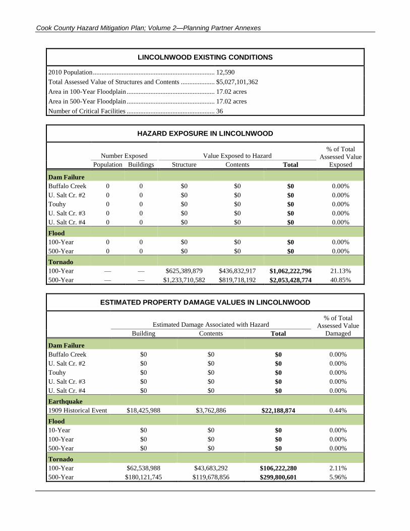
LINCOLNWOOD EXISTING CONDITIONS
2010 Population ......................................................................... 12,590
Total Assessed Value of Structures and Contents ..................... $5,027,101,362
Area in 100-Year Floodplain ..................................................... 17.02 acres
Area in 500-Year Floodplain ..................................................... 17.02 acres
Number of Critical Facilities ..................................................... 36
HAZARD EXPOSURE IN LINCOLNWOOD
Number Exposed Value Exposed to Hazard % of Total
Assessed Value
Population Buildings Structure Contents Total Exposed
Dam Failure
Buffalo Creek 0 0 $0 $0 $0 0.00%
U. Salt Cr. #2 0 0 $0 $0 $0 0.00%
Touhy 0 0 $0 $0 $0 0.00%
U. Salt Cr. #3 0 0 $0 $0 $0 0.00%
U. Salt Cr. #4 0 0 $0 $0 $0 0.00%
Flood
100-Year 0 0 $0 $0 $0 0.00%
500-Year 0 0 $0 $0 $0 0.00%
Tornado
100-Year — — $625,389,879 $436,832,917 $1,062,222,796 21.13%
500-Year — — $1,233,710,582 $819,718,192 $2,053,428,774 40.85%
ESTIMATED PROPERTY DAMAGE VALUES IN LINCOLNWOOD
Estimated Damage Associated with Hazard % of Total
Assessed Value
Building Contents Total Damaged
Dam Failure
Buffalo Creek $0 $0 $0 0.00%
U. Salt Cr. #2 $0 $0 $0 0.00%
Touhy $0 $0 $0 0.00%
U. Salt Cr. #3 $0 $0 $0 0.00%
U. Salt Cr. #4 $0 $0 $0 0.00%
Earthquake
1909 Historical Event $18,425,988 $3,762,886 $22,188,874 0.44%
Flood
10-Year $0 $0 $0 0.00%
100-Year $0 $0 $0 0.00%
500-Year $0 $0 $0 0.00%
Tornado
100-Year $62,538,988 $43,683,292 $106,222,280 2.11%
500-Year $180,121,745 $119,678,856 $299,800,601 5.96%

HAZARD MAPPING FOR LINCOLNWOOD

^
kj
kjkj
kj
kj
kjkjkj
kjkj
åÙ
åÙ
åÙåÙ
åÙ
åÙ
åÙ
åÙ åÙ
åÙ
åÙ
åÙ
åÙ
åÙåÙåÙ
åÙ
åÙ
åÙ
åÙ
åÙ
åÙ
åÙ
åÙåÙåÙ
åÙ
åÙ
åÙ
åÙ
åÙ
åÙ
åÙ
åÙ
åÙ
åÙ
åÙ
åÙ
åÙ
c_
c_
Ñ
Ñ
Ñ
Ñ
Ñ
Ñ
Ñ
Ñ
Ñ
Ñ
Ñ
Ñ
Ñ
ÑÑ
Ñ
Ñ
Ñ
Ñ
Ñ
ÑÑ
Ñ
Ñ
ÑÑ
Ñ
Ñ
ÑÑ
Ñ
Ñ
Ñ
Ñ
Ñ
Ñ
Ñ
Ñ
"X
"X
"X
"X"X
"X
"X
89:i
89:i
úú
úúú
ú
ú
ú ú
ú
ú
ú ú
ú
ú
ú
ú ú
úú
ú
ú
ú ú
ú ú ú ú úú
ú
ú
ú
ú
ú
ú
ú
ú
ú
ú
ú
úú
ú ú
ú
%defgc%defgc
%defgc
%defgc
%defgc
%defgc
%defgc
%defgc
%defgc
%defgc
%defgc
%defgc
%defgc%defgc
%defgc
%defgc
%defgc
%defgc
%defgc
%defgc
%defgc
%defgc
%defgc
%defgc
%defgc
%defgc
%defgc
%defgc
%defgc
%defgc
%defgc
%defgc
%defgc
%defgc
%defgc%defgc
%defgc
%defgc
%defgc
%defgc
%defgc
%defgc
%defgc
%defgc
%defgc
%defgc
%defgc
%defgc
%defgc
%defgc
%defgc
%defgc
%defgc
%defgc
%defgc
%defgc
%defgc
%defgc
%defgc
%defgc
%defgc
%defgc
%defgc
%defgc
%defgc
%defgc
%defgc
%defgc
%defgc%defgc
%defgc
%defgc
%defgc
%defgc
%defgc
%defgc
%defgc
%defgc
%defgc
%defgc
%defgc
¬«
¬«
¬«
¬«
¬«
¬«
¬«
¬«
¬«
¬«
¬«¬«
"O$
"O$
"O$
hh
h
h
h
h
h
NORT
H SH
ORE C
HANN
EL
£¤14
£¤41
¬«50
§̈¦94
N CE
NTRA
L AVE
W TOUHY AVE
W DEVON AVE
N CALDWELL AVE
HOWARD ST
NP ULASK IRD
N LINCOLN AVE
W PETERSON AVE
CRAW
FORD
AVE
N CIC
ERO A
VE
OAKTON ST
N CRA
WFOR
D AVE
EDEN
SEX
PY
NILES
CEN
TER
RD
LINCOLN AVE
SKOK
IE BL
VD
N KED
ZIE AV
E
MCCO
RMIC
K BLV
D
.
o Airport Facilityh Bus Facility
¥v¤ Dams
"O$ Emergency Operations Center
¬« Fire Station Facility
%defgc Hazardous Materialsú Highway Bridge
89:i Light Rail Bridge
"X Light Rail Facility
Ñ Medical Care Facility
¥K¢ Military
!5 Oil Facility
c_ Police Station Facility
Î Port Facility
po Potable Water Facility
"X Rail Facility
89:i Railway Bridge
åÙ School Facility
kj Other Facility
0 0.25 0.5Miles
VILLAGE OFLINCOLNWOOD
Base Map Data Sources:Cook County, U.S. Geological Survey
Critical Facililties

^
NORT
H SH
ORE C
HANN
EL
£¤14
£¤41
¬«50
§̈¦94
N CE
NTRA
L AVE
W TOUHY AVE
W DEVON AVE
N CALDWELL AVE
HOWARD ST
NP ULASK IRD
N LINCOLN AVE
W PETERSON AVE
CRAW
FORD
AVE
N CIC
ERO A
VE
OAKTON ST
N CRA
WFOR
D AVE
EDEN
SEX
PY
NILES
CEN
TER
RD
LINCOLN AVE
SKOK
IE BL
VD
N KED
ZIE AV
E
MCCO
RMIC
K BLV
D.
I (Not Felt)II-III (Weak)IV (Light)V (Moderate)VI (Strong)VII (Very Strong)VIII (Severe)IX (Violent)X+ (Extreme)
0 0.25 0.5Miles
VILLAGE OFLINCOLNWOOD
Base Map Data Sources:Cook County, U.S. Geological Survey
Modified Mercalli Intensity
Event Date of May 26, 1909. Originalmagnitude of 5.0; increased magnitude foranalysis of 6.0. Depth: 10 km. EpicenterLat/Long: 41.6N 88.1WAn Epicenter Map is derived from a databaseof historical earthquakes developed from threesources (Composite Earthquake Catalog,2002, Earthquake Data Base, 2002, andEarthquake Seismicity Catalog, 1996). Thedatabase has been sorted to remove historicalearthquakes with magnitudes less than 5.0.The Epicenter Map is based on a historicalearthquake epicenter, selected from thedatabase.
Illinois Historical1909 Earthquake

^
National Earthquake Hazard Reduction Program (NEHRP)
Soil Classification
NORT
H SH
ORE C
HANN
EL
§̈¦94
¬«50
£¤14
£¤41
N CE
NTRA
L AVE
W DEVON AVE
N CALDWELL AVE
HOWARD ST
W TOUHY AVE
N PUL
ASKI
RD N LINCOLN AVE
W PETERSON AVE
CRAW
FORD
AVE
N CIC
ERO A
VE
OAKTON ST
N CRA
WFOR
D AVE
E DE N
SEXP
Y
NILES
CEN
TER
RD
LINCOLN AVE
SKOK
IE BL
VD
MCCO
RMIC
K BLV
D.
Soil classification data provided by the IllinoisState Geological Society.The procedures outlined in the NEHRPprovisions (Building Seismic Safety Council,2004) and the 2003 International BuildingCodes (International Code Council, 2002)were followed to produce the soil site classmaps. Central U.S. Earthquake Consortium(CUSEC) State Geologists used the entirecolumn of soil material down to bedrock anddid not include any bedrock in the calculationof the average shear wave velocity for thecolumn, since it is the soil column and thedifference in shear wave velocity of the soils incomparison to the bedrock which influencesmuch of the amplification.
Site ClassA - Hard RockB - RockC - Very Dense Soil, Soft RockD - Stiff SoilE - Soft SoilF - Site-Specifc Evaluation
0 0.25 0.5Miles
Base Map Data Sources:Cook County, U.S. Geological Survey
VILLAGE OFLINCOLNWOOD

^
FEMA DFIRMFlood Hazard Areas
NORT
H SH
ORE C
HANN
EL
§̈¦94
N CE
NTRA
L AVE
W TOUHY AVE
W DEVON AVE
N CALDWELL AVE
HOWARD ST
NP ULASK IRD
N LINCOLN AVE
W PETERSON AVE
CRAW
FORD
AVE
N CIC
ERO A
VE
OAKTON ST
N CRA
WFOR
D AVE
EDEN
SEX
PY
NILES
CEN
TER
RD
LINCOLN AVE
SKOK
IE BL
VD
N KED
ZIE AV
EN K
EDZIE
AVE
MCCO
RMIC
K BLV
D.
Flood hazard areas as depicted on FEMADigital Flood Insurance Rate Maps (DFIRM).The 1 percent annual flood hazard iscommonly referred to as the 100 yearfloodplain.
Floodway1 Percent Annual Flood HazardFlood Depth
Value20 ft
-1 ft
0 0.25 0.5Miles
Base Map Data Sources:Cook County, U.S. Geological Survey
VILLAGE OFLINCOLNWOOD

^
Liquefaction Susceptibility
NORT
H SH
ORE C
HANN
EL
§̈¦94
¬«50
£¤14
£¤41
N CE
NTRA
L AVE
W TOUHY AVE
W DEVON AVE
N CALDWELL AVE
HOWARD ST
NP ULASK IRD
N LINCOLN AVE
W PETERSON AVE
CRAW
FORD
AVE
N CIC
ERO A
VE
OAKTON ST
TOUHY AVE
N CRA
WFOR
D AVE
EDEN
SEX
PY
NILES
CEN
TER
RD
LINCOLN AVE
SKOK
IE BL
VD
N KED
ZIE AV
E
MCCO
RMIC
K BLV
D.
Liquefaction data provided by the Illinois StateGeological Society. Liquefaction data basedon the Youd and Perkins (1978) method.A liquefaction susceptibility map provides anestimate of the likelihood that soil will liquefyas a result of earthquake shaking. This type ofmap depicts the relative susceptibility in arange that varies from very low to high. Areasunderlain by bedrock or peat are mappedseparately as these earth materials are notliquefiable, although peat deposits may besubject to permanent ground deformationcaused by earthquake shaking.
SusceptibleHighModerate to HighModerateLow to ModerateLowVery Low to LowVery Low
Not SusceptibleBedrockPeatWaterIce
0 0.25 0.5Miles
Base Map Data Sources:Cook County, U.S. Geological Survey
VILLAGE OFLINCOLNWOOD
^
§̈¦94
¬«50
£¤14
£¤41
W DEVON AVE
HOWARD ST
W TOUHY AVE
OAKTON ST
N LINCOLN AVE
W PETERSON AVE
N CIC
ERO A
VE N CRA
WFOR
D AVE
N KED
ZIE AV
E
.0 0.25 0.5Miles
Base Map Data Sources:Cook County, U.S. Geological Survey
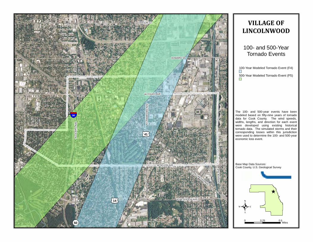
100-Year Modeled Tornado Event (F4)
500-Year Modeled Tornado Event (F5)
The 100- and 500-year events have beenmodeled based on fifty-nine years of tornadodata for Cook County. The wind speeds,widths, lengths, and direction for each eventwere developed using existing historicaltornado data. The simulated storms and theircorresponding losses within this jurisdictionwere used to determine the 100- and 500-yeareconomic loss event.
100- and 500-YearTornado Events
VILLAGE OFLINCOLNWOOD