chapter 530 limited access control - washington state ... · chapter 530 limited access control ......
TRANSCRIPT

WSDOT Design Manual M 22-01.13 Page 530-1 July 2016
Chapter 530 Limited Access Control 530.01 General 530.02 Achieving Limited Access 530.03 Full Control (Most Restrictive) 530.04 Partial Control 530.05 Modified Control (Least Restrictive) 530.06 Access Approaches 530.07 Frontage Roads
530.08 Turnbacks 530.09 Adjacent Railroads 530.10 Changes to Existing Limited Access
Rights of Way (including Access, Occupancy, and Use)
530.11 Documentation
530.01 General
Limited access control is established to preserve the safety and efficiency of specific highways and to preserve the public investment. Limited access control is achieved by acquiring access rights from abutting property owners and by selectively limiting approaches to a highway. (For an overview of access control and the references list and definitions of terminology for this chapter, see Chapter 520, Access Control.)
Requirements for the establishment of limited access highways are set forth in the Revised Code of Washington (RCW) 47.52. The type of access control applied to a location is considered a design control (see Chapter 1103), and is determined during planning, scoping, or the early stages of design in conformance with this chapter.
Highways controlled by acquiring abutting property owners’ access rights are termed limited access highways and are further distinguished as having full, partial, or modified control. The number of access points per mile, the spacing of interchanges or intersections, and the location of frontage roads or local road/street approaches are determined by the:
• Functional classification and importance of the highway
• Character of the traffic
• Current and future land use
• Environment and aesthetics
• Highway design and operation
• Economic considerations involved
The Federal Highway Administration (FHWA) has jurisdiction on the Interstate System. The Washington State Department of Transportation (WSDOT) has full jurisdiction on all other limited access highways, whether they are inside or outside incorporated city limits.
WSDOT maintains a record of the status of limited access control, by state route number and milepost, in the Access Control Tracking System Limited Access and Managed Access Master Plan database (Access Master Plan).
Nothing in this chapter is to be construed in any way that would prevent acquisition of short sections of full, partial, or modified control of access.

Limited Access Control Chapter 530
Page 530-2 WSDOT Design Manual M 22-01.13 July 2016
530.02 Achieving Limited Access
530.02(1) Evaluation
The benefits of maintaining or acquiring full, partial, or modified control is to be evaluated during project development if the route is shown in the Access Control Tracking System Limited Access and Managed Access Master Plan database as either “established” or “planned” for limited access. It is generally known that full limited access control applies to interstates and freeways. However, state highways that do not fall under full access control may have more flexibility in the type of control applied (whether limited or managed control). These highways can benefit by having access control evaluations conducted early in project development.
The cost of acquiring limited access is evaluated to determine whether those costs will be included in the project. The evaluation includes the societal costs of crashes, current and future land use development, and the improved level of service of limited access highways. Use the Basis of Design documentation tool to summarize key results of the evaluation process. (See chapters in the 1100 series for more information on using the Basis of Design tool.)
530.02(2) Process
All Washington State highways are managed access highways (see Chapter 540), except where limited access rights have been acquired. The right of way and limited access plans for routes show the acquired limited access boundaries. This is further represented in the Access Control Tracking System, a database that identifies the status and type of access control for all state highways. The database lists the specific types of limited access control (full, partial, or modified) and identifies whether the control is planned, established, or acquired for a specific route segment. If limited access has not been acquired, the database reports the type of managed access classification that currently applies.
The existing access classification is periodically updated to reflect changes on a corridor segment. The planned limited access reflects the vision for access on a corridor by resolution from the Washington Transportation Commission in the 1960s and 1970s. Conditions may have changed since the plan for limited access was envisioned. It is important to re-evaluate this plan and determine the access design control most appropriate for the agreed context. (See Chapters 1102 and 1103 for context and design control guidance, respectively.) For help determining the status of limited access control for any state highway, consult the Headquarters (HQ) Access and Hearings Section.
The Access Master Plan database is available at: www.wsdot.wa.gov/design/accessandhearings
530.02(2)(a) Procedure for Limited Access Control
Use the following procedure to achieve limited access control:
1. The Secretary of Transportation (or a designee) first identifies a highway as “Planned for Limited Access.”
2. To establish or revise limited access on a new or existing highway, a limited access hearing is held. (See Chapter 210, Public Involvement and Hearings, regarding hearings, and Chapter 510, Right of Way, for the phases of appraisal and acquisition.)

Chapter 530 Limited Access Control
WSDOT Design Manual M 22-01.13 Page 530-3 July 2016
a. Phase 1
The region develops a limited access report and a limited access report plan for department approval and presentation to local officials. The plan notes the level of limited access proposed to be established.
b. Phase 2
The region develops a limited access hearing plan for Director & State Design Engineer, Development Division (or designee), approval and for presentation at the hearing.
c. Phase 3
After the hearing, the region develops the findings and order and revises the limited access hearing plan to become the findings and order plan (see Chapter 210). The findings and order is processed and sent to the HQ Access and Hearings Section for review and approval. The Assistant Secretary, Engineering & Regional Operations, adopts the findings and order and thus establishes the limits and level of limited access control to be acquired.
d. Phase 4
The findings and order plan is now revised by the HQ Right of Way Plans Section for approval by the Director & State Design Engineer, Development Division (or designee), as a Phase 4 final right of way and limited access plan.
3. Real Estate Services acquires limited access rights from individual property owners based on final design decisions and updates the right of way and limited access plans and the property deed.
4. These highways or portions thereof are now limited access highways and no longer fall under the managed access program.
530.02(3) Access Report (RCW 47.52.131)
The Access Report is developed by the region to legally inform local governmental officials of the proposed limited access highway and the principal access features involved, and to secure their approval. This report is not furnished to abutting property owners. Submit the report to the HQ Access and Hearings Section for review and approval prior to submission to local authorities. Including local agencies as stakeholders from the onset of the project helps establish project expectations and positive working relationships, making reviews and approvals run as smoothly as possible.
530.02(3)(a) Access Report Content
The Access Report consists of the following:
1. A description of the existing and proposed highways, including data on the history of the existing highway, which may include references to crashes and locations identified in WSDOT’s Priority Array.
2. Traffic analyses pertaining to the proposed highway, including available information about current and potential future traffic volumes on county roads and city streets crossing or severed by the proposed highway and reference sources such as origin-destination surveys.

Limited Access Control Chapter 530
Page 530-4 WSDOT Design Manual M 22-01.13 July 2016
Traffic data developed for the Design Decision Summary, together with counts of existing traffic available from state or local records, is normally adequate. Special counts of existing traffic are obtained only if circumstances indicate that the available data is inadequate or outdated.
3. A discussion of factors affecting the design of the subject highway, including: • Functional classification www.wsdot.wa.gov/mapsdata/travel/hpms/functionalclass.htm
• Level and limits of limited access control. • Roadway section. • Interchange, grade separation, and intersection spacing. • Pedestrian and bicycle trails or paths. • Operational controls with emphasis on proposed fencing, the general concept of
illumination, signing, and other traffic control devices. • Location of utilities and how they are affected. • Proposed plan for landscaping and beautification, including an artist’s graphic
rendition or design visualization.
4. Governmental responsibility, and comprehensive planning, land use, and community service relative to the new highway.
5. The disposition of frontage roads, city street and county road intersections, and excess right of way.
6. An appendix containing: • A glossary of engineering terms. • A traffic volume diagram(s). • Pages showing diagrammatically or graphically the roadway section(s), operational
controls, and rest areas (if rest areas are included in the project covered by the report).
• A vicinity map. • An access report plan and profiles for the project.
The limited access report plan shows the effects of the proposed highway on the street and road system by delineating the points of public access. (See the Plans Preparation Manual for a list of the minimum details to be shown on the plan and for a sample plan.)
7. Notifications and reviews. Upon receipt of the Phase 1 approval (see Exhibit 510-1) from the Director & State Design Engineer, Development Division, the region publishes the necessary copies, submits the limited access report to the county or city officials for review and approval, and meets with all involved local governmental agencies to discuss the report. Providing a form letter with a signature block for the local agency to use to indicate its approval of the limited access report can help expedite the review and approval process.
The region reviews any requests for modification and submits recommendations, with copies of any correspondence or related minutes, to the HQ Access and Hearings Section.
530.02(4) Limited Access Hearing Plan
The region prepares a limited access hearing plan to be used as an exhibit at the public hearing (see Chapter 210 for hearings) and forwards it to the HQ Right of Way Plans Section for review.
Chapter 530 Limited Access Control
WSDOT Design Manual M 22-01.13 Page 530-5 July 2016
(See the Plans Preparation Manual for a list of data to be shown on the access hearing plan in addition to the access report plan data.)
When the plan review is completed by Headquarters, the access hearing plan is placed before the Director & State Design Engineer, Development Division, for approval of Phase 2 authority (see Exhibit 510-1).
530.02(5) Documentation
Documentation for the establishment of limited access control is in Chapter 210.
530.03 Full Control (Most Restrictive)
530.03(1) Introduction
Full control limited access highways provide almost complete freedom from disruption by allowing access only through interchanges at selected public roads/streets, rest areas, viewpoints, or weigh stations, and by prohibiting at-grade crossings and approaches. Gated approaches are occasionally allowed, with approval of the requirements listed in Chapter 550 and Exhibits 550-1 and 2.
At times, on state highways (except interstate) where full access control has been established, staged acquisition of limited access may be used, subject to the approval of an access design analysis, with initial acquisition as partial or modified control and with ultimate acquisition of full control planned on the highway. When there is no feasible alternative within a reasonable cost, the decision to defer acquisition of limited access control must be documented and is subject to the approval of an access design analysis.
530.03(2) Application
Terminate full control limited access sections at apparent logical points of design change. The following guidelines are to be used for the application of full control on limited access highways.
530.03(2)(a) Interstate
Full control is required on interstate highways.
530.03(2)(b) Principal Arterial
Documentation assessing the evaluation of full control is required for principal arterial highways requiring four or more through traffic lanes within a 20-year design period unless approved for partial or modified control on existing highways.
530.03(2)(c) Minor Arterial and Collector
Minor arterial and collector highways will not normally be considered for development to full control.
530.03(3) Crossroads at Interchange Ramps
The extension of limited access control beyond an intersection is measured from the centerline of ramps, crossroads, or parallel roads (as shown in Exhibits 530-1a, 1b, and 1c), from the terminus of transition tapers (see Exhibit 530-1d), and in the case of ramp terminals at single

Limited Access Control Chapter 530
Page 530-6 WSDOT Design Manual M 22-01.13 July 2016
point urban interchanges (as shown in Exhibit 530-1e). For guidance on interchange spacing, see Chapter 1360.
530.03(3)(a) Ramps
At-grade intersections and approaches are prohibited within the full length of any interchange ramp. The ramp is considered to terminate at its intersection with the local road or street.
530.03(3)(b) Frontage Roads
Direct access from the highway to a local service or frontage road is allowed only via the interchange crossroad (see Exhibits 530-1a, 1b, and 1c).
530.03(3)(c) Interchange Crossroads
In both urban and rural areas, full control limited access must be established and then acquired along the crossroad at an interchange for a minimum distance of 300 feet beyond the centerline of the ramp or the end of the transition taper.
If a frontage road or local road is located at or within 350 feet of a ramp, limited access will be established and then acquired along the crossroad and for an additional minimum distance of 130 feet in all directions from the centerline of the intersection of the crossroad and the frontage or local road (see Exhibits 530-1a, 1b, and 1c).
For interchanges incorporating partial cloverleaf or buttonhook ramps (see Exhibit 530-1b), limited access is required for all portions of the crossroad and frontage roads between the ramp terminals and for a distance of 300 feet beyond the ramp terminals. If an at-grade intersection for a local road or street is served directly opposite the ramp terminals, limited access will be extended for a minimum of 300 feet along that leg of the intersection.
When the intersection in question is a roundabout, see Exhibit 530-1c. This shows extension of full control to be 300 feet, measured from the center of the roundabout for an intersection with a ramp terminal. Exhibit 530-1c also shows that if a frontage road or local road is located at or within 350 feet of a ramp terminal, limited access will be established and then acquired along the crossroad (between the roundabouts) and for an additional minimum distance of 130 feet in all directions along the local frontage roadway, measured from the outside edge of the circulating roadway of the roundabout.
Exhibit 530-1d shows the terminus of transition taper and that full control limited access is extended a minimum distance of 300 feet beyond the end of the farthest taper.
For a single point urban interchange (SPUI) with a right- or left-turn “ramp branch” separated by islands, limited access control is established and acquired for a minimum distance of 300 feet from the intersection of the centerline of the ramp branch with the centerline of the nearest directional roadway (see Exhibit 530-1e.)
Not all interchange configurations match with the basic illustrations in this chapter. Consult with the HQ Access and Hearings Section for confirmation of limited access boundary requirements for non-traditional interchange configurations.

Chapter 530 Limited Access Control
WSDOT Design Manual M 22-01.13 Page 530-7 July 2016
530.03(3)(d) Levels of Limited Access: Location of Approaches
Provide full control for a minimum of 300 feet from the centerline of the ramp or terminus of a transition taper (see Exhibits 530-1a, 1b, 1c, 1d, and 1e). The intent is to ensure approaches are far enough away from a frontage road intersection to provide efficient intersection operation.
If the economic considerations to implement full control for the entire 300 feet are excessive, then provide full control for at least the first 130 feet; partial or modified control may be provided for the remainder, for a total minimum distance of 300 feet of limited access. Full limited access should be extended as far as possible before any partial or modified access is implemented. Contact the HQ Access and Hearings Section when considering this option.
An approved access design analysis is required if the limited access control falls short of 300 feet or for any approach that has been allowed to remain within the first 130 feet.
530.03(4) Location of Utilities, Bus Stops, and Mailboxes
530.03(4)(a) Utilities
Connecting utility lines are allowed along the outer right of way line between intermittent frontage roads. (See the Utilities Accommodation Policy regarding the location of and access to utilities.)
530.03(4)(b) Bus Stops
Common carrier or school bus stops are not allowed, except at:
• Railroad crossings (see Chapter 1350).
• Locations provided by the state on the interchanges (such as flyer stops).
• In exceptional cases, along the main roadway where pedestrian separation is available.
530.03(4)(c) Mailboxes
Mailboxes are not allowed on full control limited access highways. Mail delivery will be from frontage roads or other adjacent local roads.
530.03(5) Pedestrian and Bicycle Crossings and Paths
All nonmotorized traffic is limited as follows:
• At-grade pedestrian crossings are allowed only at the at-grade intersections of ramp terminals.
• Pedestrian separations or other facilities are provided specifically for pedestrian use.
• Bicyclists use facilities provided specifically for bicycle use (separated paths).
• Shared-use paths are only for bicyclists, pedestrians, and other forms of nonmotorized transportation.
• Bicyclists use the right-hand shoulders, except where such use has been specifically prohibited. Information pertaining to such prohibition is available from the WSDOT website: wsdot.wa.gov/bike/closed.htm

Limited Access Control Chapter 530
Page 530-8 WSDOT Design Manual M 22-01.13 July 2016
Paths and trails, and access to and from, within a limited access highway are best planned and designed with the local agency’s participation. Pedestrians and bicycles are allowed, consistent with “Rules of the Road” (RCW 46.61), within the limits of full control limited access highways. Where paths are allowed they must be documented on the right of way and limited access plan. The plan shows the location of the path and where the path crosses limited access and provides movement notes (see 530.10(1)).
530.04 Partial Control
530.04(1) Introduction
Partial control may be established, when justified, on any highway except interstate. Partial control provides a considerable level of protection from traffic interference and protects the highway from future strip-type development.
Upon acquisition of partial control limited access rights, the number, type, and use of access approaches of abutting property are frozen. The abutting property access rights and type of use are recorded on the property deed. The rights and use may not be altered by the abutting property owner, the local jurisdiction, or the region. This authority resides with the Director & State Design Engineer, Development Division (see 530.10).
530.04(2) Application
Partial control will not normally be used in urban areas or inside corporate limits on existing principal arterial highways where traffic volumes are less than 700 design hourly volume (DHV).
Terminate limited access sections at apparent logical points of design change.
530.04(2)(a) Principal Arterial
Partial control is required when the estimated traffic volumes exceed 3,000 average daily traffic (ADT) within a 20-year design period on principal arterial highways requiring two through traffic lanes. For multilane principal arterial highways, see 530.03(2)(b).
530.04(2)(b) Minor Arterial
The minimum route length is: urban, 2 miles; rural, 5 miles; and combination urban and rural, 3 miles.
Partial control is required on:
• Rural minor arterial highways at both new and existing locations.
• Urban minor arterial highways at new locations requiring four or more through traffic lanes within a 20-year design period or requiring only two through traffic lanes where the estimated traffic volumes exceed 3,000 ADT within a 20-year design period.
Other rural minor arterial highways with only two lanes may be considered for partial control if any of the following conditions applies:
• The partial control can be acquired at a reasonable cost.
• The route connects two highways of a higher functional classification.

Chapter 530 Limited Access Control
WSDOT Design Manual M 22-01.13 Page 530-9 July 2016
• The potential land development can result in numerous individual approaches, such as encountered in recreational or rapidly developing areas.
• The highway traverses publicly owned lands where partial control is desirable.
530.04(2)(c) Collector: New Alignment
Partial control is required on collector highways in new locations requiring four or more through traffic lanes in a 20-year design period.
530.04(2)(d) Collector: Existing
Existing collector highways will normally be considered for partial control limited access only when all of the following conditions apply:
• The highway serves an area that is not directly served by a higher functional classification of highway.
• Existing or planned development will result in traffic volumes significantly higher than what is required for partial control on minor arterials.
• Partial control can be established without a major impact on development of abutting properties within the constraints of established zoning at the time the partial control is proposed.
530.04(3) Interchanges and Intersections
530.04(3)(a) Interchanges
Where an interchange occurs on a partial control limited access highway, full control applies at the interchange and interchange ramps. Refer to 530.03(3) and see Exhibits 530-1a, 1b, and 1c for required minimum lengths of access control along the crossroad. For these and other interchange configurations not shown, consult with the HQ Access and Hearings Section for support developing limits of access control. (See Chapter 1360 for guidance on interchange spacing.)
530.04(3)(b) Intersections
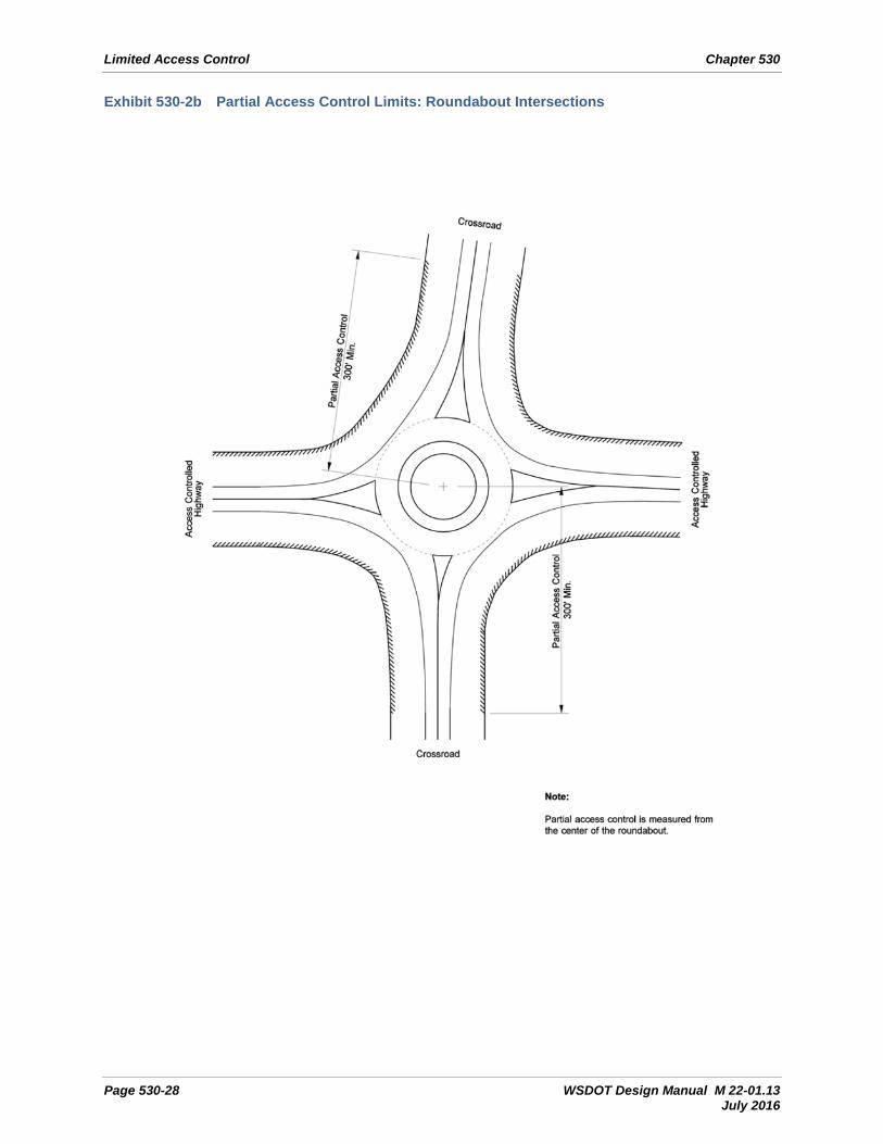
At an at-grade intersection on a partial control limited access highway, control will be established and acquired along the crossroad for a minimum distance of 300 feet from the centerline of the highway (see Exhibit 530-2a).
If another frontage or local road is located at or within 350 feet of the at-grade intersection, limited access will be established and then acquired along the crossroad, between the intersections, and:
• For an additional minimum distance of 130 feet in all directions from the centerline of the intersection of the frontage or local road (see Exhibit 530-2a).
• In the case of a roundabout, for an additional minimum distance of 300 feet along the crossroad, measured from the center of the roundabout (as shown in Exhibit 530-2b).
On multilane highways, measurements will be made from the centerline of the nearest directional roadway (see Exhibit 530-2a).

Limited Access Control Chapter 530
Page 530-10 WSDOT Design Manual M 22-01.13 July 2016
An approved access design analysis is required if the limited access control falls short of 300 feet or for any access that has been allowed to remain within the first 130 feet.
At-grade intersections with public roads are limited to the number allowed for the functional classification of highway involved, as follows:
530.04(3)(b)(1) Principal Arterial
If the ADT of the crossroad is less than 2,000, 1-mile spacing (minimum), centerline to centerline. If over 2,000 ADT within 20 years, plan for grade separation.
530.04(3)(b)(2) Minor Arterial
If the ADT of the crossroad is less than 2,000, ½-mile spacing (minimum), centerline to centerline. If over 2,000 ADT within 20 years, plan for grade separation.
530.04(3)(b)(3) Collector
Road (or street) plus property approaches, not more than six per side per mile.
With approval from the Director & State Design Engineer, Development Division, shorter intervals may be used where topography or other conditions (such as parcel sizes in some cases) restrict the design. Where intersecting roads are spaced farther apart than one per mile, median crossings may be considered for U-turns, in accordance with Chapter 1310. Keep U-turns to a minimum, consistent with requirements for operation and maintenance of the highway.
To discourage movement in the wrong direction on multilane highways, locate private approaches 300 feet or more from an at-grade intersection. At a tee intersection, a private approach may be located directly opposite the intersection or a minimum of 300 feet away from the intersection. Ensure a private approach directly opposite a tee intersection cannot be mistaken for a continuation or part of the public traveled way.
530.04(4) Access Approach
Partial control is exercised to the level that, in addition to intersections with selected public roads, some crossings and private driveways may be allowed.
530.04(4)(a) Approach Types
Partial control limited access highways allow at-grade intersections with selected public roads and private approaches using Type A, B, C, and F approaches. (See Chapter 520 for the definitions of approach types.)
Type D, commercial approaches, are not allowed direct access to partial control limited access highways. Commercial access is allowed only by way of public roads.
The type of approach provided for each parcel is based on current and potential land use and on an evaluation. (See 530.05(4) for a list of evaluation criteria.)

Chapter 530 Limited Access Control
WSDOT Design Manual M 22-01.13 Page 530-11 July 2016
530.04(4)(b) Design Considerations
The following considerations are used to determine the number and location of access approaches on partial control limited access highways.
1. Access approaches must be held to a minimum. The number is limited as follows: • Principal arterial: two per side per mile
• Minor arterial: four per side per mile
• Collector: six per side per mile, including at-grade intersections
2. Approaches in excess of the number listed above may be allowed as staged construction (until full buildout is complete) if approved by the Director & State Design Engineer, Development Division.
3. Approaches are not allowed for parcels that have reasonable access to other public roads unless a parcel has extensive highway frontage.
4. Relocate or close approaches in areas where sight limitations create undue hazards.
5. Allow only one approach for each parcel, except for very large ownerships, or where terrain features do not allow the property to be served by a single approach. This includes contiguous parcels under a single ownership.
6. Where possible, locate a single approach to serve two or more parcels.
7. The approved design is to provide for future development of frontage roads that will eliminate an excessive number of approaches.
530.04(5) Location of Utilities, Bus Stops, and Mailboxes
530.04(5)(a) Utilities
Connecting utility lines are allowed along the outer right of way line between intermittent frontage roads. (See the Utilities Accommodation Policy regarding the location of and access to utilities.)
530.04(5)(b) Bus Stops
Bus stops for both common carriers and school buses are not allowed on either two-lane or four-lane highways except:
• At railroad crossings (see Chapter 1350).
• At locations of intersections with necessary pullouts to be constructed by the state.
• Where shoulder widening has been provided for mail delivery service.
• For a designated school bus loading zone on or adjacent to the traveled lane, that has been approved by WSDOT.
Buses are not allowed to stop in the traveled lanes blocking at-grade intersections or private approaches to load or unload passengers.
School bus loading zones on partial control limited access highways must be posted with school bus loading zone signs, in accordance with the latest edition of the Manual on Uniform Traffic Control Devices (MUTCD).

Limited Access Control Chapter 530
Page 530-12 WSDOT Design Manual M 22-01.13 July 2016
530.04(5)(c) Mailboxes
Locate mailboxes on frontage roads or at intersections, with the following exceptions for properties that are served by Type A or B approaches:
• Locate mailboxes on a four-lane highway only on the side of the highway on which the deeded approach is provided.
• Locate mailboxes on a two-lane highway on the side of the highway that is on the right in the direction of the mail delivery.
Wherever mailboxes are allowed on a partial control limited access highway, provide mailbox turnouts to allow mail delivery vehicles to stop clear of the through traffic lanes. (See Chapter 1600 for additional information concerning mailbox locations and turnouts.)
530.04(6) Pedestrian and Bicycle Crossings and Paths
Pedestrian crossings are allowed on partial control limited access highways when they are grade-separated.
At-grade pedestrian crossings are allowed:
• Only at intersections where an at-grade crossing is provided in accordance with Chapter 1510.
• On two-lane highways at mailbox locations.
• On two-lane highways not less than 100 feet from a school bus loading zone (pullout) adjacent to the traveled lane, if school district and WSDOT personnel determine that stopping in the traveled lane is hazardous.
• On two-lane highways where the school bus is stopped on the traveled lane to load or unload passengers and the required sign and signal lights are displayed.
On partial control limited access highways, pedestrian and bicycle traffic is allowed, consistent with “Rules of the Road” (RCW 46.61), except where unusual safety conditions support prohibition. Information pertaining to such prohibitions is available from the WSDOT website: wsdot.wa.gov/bike/closed.htm
Paths and trails, and access to and from, within a partial control limited access highway are best planned and designed with the local agency’s participation. Where paths are allowed, they must be documented on the right of way and limited access plan. The plan shows the location of the path and where the path crosses limited access, and it provides movement notes (see 530.10(1)).
530.05 Modified Control (Least Restrictive)
530.05(1) Introduction
Modified control is intended to prevent further deterioration in the safety and operational characteristics of existing highways by limiting the number and location of access points.
Upon acquisition of modified control limited access, the number, type, and use of access approaches of abutting property are frozen. The abutting property access rights and type of use are recorded on the property deed. The rights and use may not be altered by the abutting

Chapter 530 Limited Access Control
WSDOT Design Manual M 22-01.13 Page 530-13 July 2016
property owner, the local jurisdiction, or the region. This authority resides with the Director & State Design Engineer, Development Division (see 530.10).
530.05(2) Application
In general, modified control is applied where some level of control is desired, but existing and potential commercial development precludes the implementation of full or partial control.
530.05(2)(a) Existing Highways
Modified control may be established and acquired on existing highways other than main line interstate. Priority is given to highway segments where one or more of the following conditions applies:
• Commercial development potential is high, but most of the adjoining property remains undeveloped.
• There is a reasonable expectation that the adjoining property will be redeveloped to a more intensive land use, resulting in greater traffic congestion.
• At interchange areas if full or partial access cannot be provided as described in 530.03(3)(d).
530.05(2)(b) Modified Control Evaluation
Selection of highways on which modified control may be applied is based on an evaluation that includes the following contextual factors:
• The current form of managed access control
• Traffic volumes
• Level of service, or other selected mobility performance metric
• Selected safety performance
• Functional class
• Route continuity
• Mix of residential and employment densities
• Operational considerations related to achieving the selected target speed
• Local land use planning
• Current and potential land use
• Predicted growth rate
• Economic analysis
530.05(2)(c) Exceptions
Where modified control is to be established, developed commercial areas may be excepted from control when all or most of the abutting property has been developed to the extent that few, if any, additional commercial approaches will be needed with full development of the area. Contact the HQ Access and Hearings Section when considering this option. If this exception is within the limits of access control, an approved access design analysis is required.

Limited Access Control Chapter 530
Page 530-14 WSDOT Design Manual M 22-01.13 July 2016
530.05(3) Intersections
At an intersection on a modified control limited access highway, access control will be established and acquired along the crossroad for a minimum distance of 130 feet:
• Measured from the centerline of a two-lane highway (see Exhibit 530-3b).
• Measured from the centerline of the nearest directional roadway of a four-lane highway (see Exhibit 530-3b).
• Measured from the outside edge of the circulating roadway of a roundabout (see Exhibit 530-3a).
Approaches are allowed within this area only when there is no reasonable alternative. An approved access design analysis is required for any access that has been allowed to remain within the first 130 feet.
530.05(4) Access Approach
The number and location of approaches on a highway with modified control must be carefully planned and monitored to provide a safe and efficient highway compatible with present and potential land use.
530.05(4)(a) Approach Types
Modified control limited access highways allow at-grade intersections with selected public roads and with private approaches using Type A, B, C, and D approaches. (See Chapter 520 for definitions of the approach types.)
The type of approach provided for each parcel is based on present and potential land use and an evaluation of the following criteria:
• Local comprehensive plans, zoning, and land use ordinances
• Property covenants and agreements
• City or county ordinances
• The highest and best use of the property
• The highest and best use of adjoining lands
• A change in use by merger of adjoining ownerships
• All other factors bearing upon proper land use of the parcel
530.05(4)(b) Design Considerations
The following items are used to determine the number and location of approaches:
1. Parcels that have access to another public road or street are not normally allowed direct access to the highway.
2. Relocate or close approaches located in areas where sight limitations create undue hazards.
Chapter 530 Limited Access Control
WSDOT Design Manual M 22-01.13 Page 530-15 July 2016
3. Hold the number of access approaches to a minimum. Access approaches are limited to one approach for each parcel of land or where adjoining parcels are under one contiguous ownership.
4. Encourage joint use of access approaches where similar use of land and topography allows.
5. Additional approaches may be allowed for future development consistent with local zoning. Once limited access has been acquired, this will require a value determination process (see 530.10).
Close existing access approaches not meeting the above.
530.05(5) Location of Utilities, Bus Stops, and Mailboxes
530.05(5)(a) Utilities
Connecting utility lines are allowed along the outer right of way line between intermittent frontage roads. (See the Utilities Accommodation Policy regarding location of and access to utilities.)
530.05(5)(b) Bus Stops and Pedestrian Crossings
Bus stops and pedestrian crossings are allowed as follows:
• In rural areas, bus stops and pedestrian crossings are subject to the same restrictions as in 530.04(5) and (6).
• In urban areas, bus stops for both commercial carriers and school buses are allowed. (See Chapter 1430 for requirements.)
530.05(5)(c) Mailboxes
Locate mailboxes adjacent to or opposite all authorized approaches as follows:
• On a four-lane highway only on the side of the highway on which the deeded approach is provided.
• On a two-lane highway on the side of the highway that is on the right in the direction of the mail delivery.
Where mailboxes are allowed, a mailbox turnout is recommended to allow mail delivery vehicles to stop clear of the through traffic lanes. (See Chapter 1600 for additional information concerning mailbox locations and turnouts.)
530.05(6) Pedestrian and Bicycle Traffic and Paths
Pedestrians and bicyclists are allowed, consistent with “Rules of the Road” (RCW 46.61), on modified control limited access highways except where unusual safety considerations support prohibition. Information pertaining to such prohibitions is available from the WSDOT website: wsdot.wa.gov/bike/closed.htm
Paths and trails, and access to and from, within a modified control limited access highway are best planned and designed with the local agency’s participation. Where paths are allowed, they must be documented in the right of way and limited access plan. The plan shows the location of the path and where the path crosses limited access, and it provides movement notes (see 530.10(1)).

Limited Access Control Chapter 530
Page 530-16 WSDOT Design Manual M 22-01.13 July 2016
530.06 Access Approaches
530.06(1) General
Access approaches may be allowed on limited access highways, consistent with the requirements outlined in 530.03, 530.04, and 530.05.
For additional information pertaining to approaches, refer to Chapters 1320 (roundabouts), 1340 (approach design templates), and 510 (right of way), and the Plans Preparation Manual.
The widths for the approach types are negotiated, and only the negotiated widths are shown on the right of way and limited access plan. (See Chapter 520 for definitions of the approach types.)
530.07 Frontage Roads
Local agency approval is required for any planned frontage roads, county roads, city streets, or cul-de-sacs. The local agency must also agree in writing to accept and maintain the new section as a county road or city street.
530.07(1) General
Frontage roads are provided in conjunction with limited access highways to:
• Limit access to the main line.
• Provide access to abutting land ownerships.
• Restore the continuity of the local street or roadway system.
Refer to Chapter 1210 for frontage road general policy and Chapter 300 for required documentation.
By agreement under which the state is reimbursed for all costs involved, frontage roads that are not the responsibility of the state may be built by the state upon the request of a local political subdivision, a private agency, or an individual.
530.07(2) County Road and City Street
To connect roads or streets that have been closed off by the highway, short sections of county roads or city streets that are not adjacent to the highway may be constructed if they will serve the same purpose as, and cost less than, a frontage road.
530.07(3) Cul-de-sacs
For a frontage road or local street bearing substantial traffic that is terminated or closed at one end, provide a cul-de-sac or other street or roadway consistent with local policy or practice, that is sufficient to allow vehicles to turn around without encroachment on private property.
530.08 Turnbacks
When WSDOT transfers jurisdiction of operating right of way to a city, town, or county, a turnback agreement is required. (See the Agreements Manual for turnback procedures.)
Chapter 530 Limited Access Control
WSDOT Design Manual M 22-01.13 Page 530-17 July 2016
Locate the turnback limits at points of logical termination. This will allow WSDOT to retain an adequate amount of right of way for maintenance of the highway and for other operational functions.
In areas where limited access rights have been acquired from the abutting property owners, the limited access rights will continue to be required for highway purposes; therefore, the limited access rights will not be included as part of a turnback agreement.
When a signalized intersection is in the area of a turnback, locate the turnback limit outside the detector loops if WSDOT is continuing the ownership, operation, and maintenance of the signal system. For a roundabout, locate the turnback limit at the back of the raised approach splitter island if WSDOT is continuing the ownership, operation, and maintenance of the roundabout.
530.09 Adjacent Railroads
530.09(1) General
A limited access highway and a railroad are considered adjacent when they have a common right of way border with no other property separating them. The allowed approaches apply only to adjacent railroad property that is directly used for current railroad operation.
530.09(2) Requirements
It is in the public’s interest to provide access to the railroad right of way, from limited access highways, for maintenance of the railroad and the utilities located on the railroad right of way where other access is not feasible. This applies to both new highways and to existing highways where limited access has been acquired.
Direct access is allowed where local roads are infrequent or there are few highway-railroad crossings from which trail-type access for maintenance purposes is feasible, and where unique topography or other unusual conditions lead to its use.
To provide direct approaches for access to railroad right of way, all of the following conditions must be met:
• A maximum of one approach is allowed for every 2 miles of highway.
• The approach must not adversely affect the design, construction, stability, traffic safety, or operation of the highway.
• Except where the railroad is located in the median area, the approach is to be accomplished in a legal manner by right turns only, to and from the roadway nearest the railroad. Median crossing is not allowed.
• The approach is secured by a locked gate under arrangements satisfactory to the department. (See the Definitions section in Chapter 520 for Approach Type C, and Chapter 550.)
• The parking of any vehicles or railroad equipment is prohibited within limited access highway right of way.
• A special emergency maintenance permit must be obtained for periods of intensive railroad maintenance.
• The approach must be closed if the railroad operation ceases.

Limited Access Control Chapter 530
Page 530-18 WSDOT Design Manual M 22-01.13 July 2016
• Approaches are limited to use by the railroad company unless specific provisions forother use are shown on the right of way and limited access plan and included in theright of way negotiations.
530.09(3) Restrictions
Direct access from the highway is considered unnecessary and is not allowed where:
• There are local roads adjacent to or crossing the railroad.
• A trail-type road can be provided by the railroad between crossroads.
• The limited access highway is paralleled by a frontage road adjacent to the railroad.
• No highway previously existed adjacent to the railroad.
530.10 Changes to Existing Limited Access Rights of Way (including Access, Occupancy, and Use)
This section addresses three topics:
• 530.10(1) applies to all changes to access, occupancy & use of limited access rights ofway on full, partial and modified highways.
• 530.10(2) provides specific detail on changes for private approaches.
• 530.10(3) provides specific guidance on changes for public approaches.
530.10(1) General
Changes to limited access control on state highways can only be made by the application of current design requirements and with the approval of the Assistant Secretary, Engineering & Regional Operations (or designee), and FHWA (when appropriate).
This means changes to access, use and occupancy (either temporary or permanent) for all limited access state highways require procedures and approval prior to implementation of those changes. On interstate routes, 23 CFR 710.401 requires prior approval from FHWA before allowing any changes on the interstate system. On non-interstate limited access routes, WSDOT approves changes to access, use and occupancy.
Example changes to limited access control: • Constructing new fence openings• Closing existing fence openings• Adding new roadway connections, like an at-grade intersection• Adding shared-use paths or trails that cross into and out of the right of way• Widening existing approaches• Allowing cranes or other equipment to temporarily encroach into the interstate
airspace• Constructing a new interchange or rebuilding an existing interchange (See Chapter 550)
Any changes proposed on interstate limited access facilities must include environmental documentation in the request, as required by FHWA. Contact the HQ Access and Hearings Section for assistance.
Chapter 530 Limited Access Control
WSDOT Design Manual M 22-01.13 Page 530-19 July 2016
Consider the following factors when evaluating a request for modification of a limited access highway: • Existing level of control on the highway • Functional classification and importance of the highway • Percentage of truck traffic • Highway operations • Present or future land use • Environment or aesthetics • Economic considerations • Safety considerations
The Region will work with the requesting party to compile and submit all access, use and occupancy documents to the HQ Access and Hearings Section. The request documents should provide adequate detail, including a specific need statement, for the intended access, occupancy or use. The request packet will become a part of the historical record for the state route.
For permanent access, use or occupancy approvals involving existing property rights, the right of way and limited access plan must be revised and deeds may need to be rewritten. Contact Region and/or HQ Real Estate Services for this effort.
Evaluate all revisions to limited access highways to determine if access hearings are required.
For requirements to be met for selected modifications to full control limited access highways such as the Interstate System and multilane state highways, see Chapter 550, Interchange Justification Report.
530.10(2) Changes for Private Access Approaches (Modified/Partial Control Only)
Private accesses are allowed within modified control and sometimes allowed within partial control (WAC 468-58-010).
530.10(2)(a) Requirements
Examples of access modifications requested by abutting property owners include additional road approaches, changes in the allowed use, or additional users of existing road approaches.
Plan revisions that provide for additional access to abutting properties after WSDOT has purchased the access rights are discouraged. However, these revisions may be considered if all of the following can be established: • There are no other reasonable alternatives. • The efficiency and safety of the highway will not be adversely impacted. • The existing situation causes extreme hardship on the owner(s). • The revision is consistent with the limited access highway requirements.
530.10(2)(b) Procedures
The region initiates a preliminary engineering review of the requested modification to or break in limited access. This preliminary review will be conducted with the HQ Access and Hearings

Limited Access Control Chapter 530
Page 530-20 WSDOT Design Manual M 22-01.13 July 2016
Section to determine whether conceptual approval can be granted for the request. If conceptual approval can be granted, then:
• The region initiates an engineering review of the requested modification.
• The region prepares and submits to the HQ Right of Way Plans Section a preliminary right of way and limited access plan revision, together with a recommendation for Headquarters approval. When federal-aid funds are involved in any phase of the project, the proposed modification will be sent to FHWA for review and approval.
• The recommendation will include an item-by-item analysis of the factors listed in 530.10(1) and 530.10(2)(a).
530.10(2)(c) Valuation Determination
Upon preliminary approval, region Real Estate Services prepares an appraisal for the value of the access change using a before and after appraisal.
• The appraisal follows the requirements set forth in the Right of Way Manual.
• The appraisal package is sent to HQ Real Estate Services for review and approval.
• If federal-aid funds were involved in purchasing access control, HQ Real Estate Services will send a copy of the appraisal package to FHWA for review and approval.
530.10(2)(d) Final Processing
• Region Real Estate Services informs the requester of the approved appraised value for the change.
• If the requester is still interested, the region prepares a “Surplus Disposal Package” for HQ Real Estate Services’ review and approval.
• At the same time, the preliminary right of way and limited access plan revision previously transmitted is processed for approval.
• After the department collects the payment from the requester, the region issues a permit for the construction, if required.
• If an existing approach is being surrendered, region Real Estate Services obtains a conveyance from the property owner.
• HQ Real Estate Services prepares and processes a deed granting the change to the access rights.
530.10(3) Changes for Public At-Grade Intersections (Modified/Partial Control Only)
530.10(3)(a) Requirements
• Public at-grade intersections on partial or modified control limited access highways serve local arterials that form part of the local transportation network.
• Requests for new intersections on limited access highways must be made by or through the local governmental agency to WSDOT. The region will forward this request, including the data referenced in 530.10(1) and 530.10(2)(a) to the HQ Access and Hearings Section.

Chapter 530 Limited Access Control
WSDOT Design Manual M 22-01.13 Page 530-21 July 2016
• WSDOT must comply with the hearing, or waiver, process as outlined in Chapter 210. The access acquisition and conveyance must be completed prior to beginning construction of the new intersection. The new intersection is to meet WSDOT design and spacing requirements.
530.10(3)(b) Procedures
• The region evaluates the request for modification and contacts the HQ Access and Hearings Section for conceptual approval.
• The region submits an intersection plan for approval (see Chapter 1310) and a right of way and limited access plan revision request (see the Plans Preparation Manual). This plan includes the limited access design requirements along the proposed public at-grade intersection.
• The Director & State Design Engineer, Development Division, approves the intersection plan.
• The Assistant Secretary, Engineering & Regional Operations (or designee), approves the access revision.
• The region submits the construction agreement to the Director & State Design Engineer, Development Division (see the Agreements Manual).
• The Assistant Secretary, Engineering & Regional Operations (or designee), approves the construction agreement.
530.10(3)(c) Valuation Determination
• When a requested public at-grade intersection will serve a local arterial that immediately connects to the local transportation network, compensation will not be required.
• When a requested public at-grade intersection will serve only a limited area, does not immediately connect to the local transportation network, or is primarily for the benefit of a limited number of developers, compensation for the access change will be addressed in the plan revision request. In these situations, compensation is appropriate and a value will be determined as outlined in 530.10(2)(c).
530.11 Documentation
Refer to Chapters 210, 300, and 550 for design documentation requirements.

Limited Access Control Chapter 530
Page 530-22 WSDOT Design Manual M 22-01.13 July 2016
Exhibit 530-1a Full Access Control Limits: Interchange

Chapter 530 Limited Access Control
WSDOT Design Manual M 22-01.13 Page 530-23 July 2016
Exhibit 530-1b Full Access Control Limits: Interchange

Limited Access Control Chapter 530
Page 530-24 WSDOT Design Manual M 22-01.13 July 2016
Exhibit 530-1c Full Access Control Limits: Interchange with Roundabouts

Chapter 530 Limited Access Control
WSDOT Design Manual M 22-01.13 Page 530-25 July 2016
Exhibit 530-1d Full Access Control Limits: Ramp Terminal with Transition Taper

Limited Access Control Chapter 530
Page 530-26 WSDOT Design Manual M 22-01.13 July 2016
Exhibit 530-1e Full Access Control Limits: Single Point Urban Interchange

Chapter 530 Limited Access Control
WSDOT Design Manual M 22-01.13 Page 530-27 July 2016
Exhibit 530-2a Partial Access Control Limits: At-Grade Intersections
Limited Access Control Chapter 530
Page 530-28 WSDOT Design Manual M 22-01.13 July 2016
Exhibit 530-2b Partial Access Control Limits: Roundabout Intersections

Chapter 530 Limited Access Control
WSDOT Design Manual M 22-01.13 Page 530-29 July 2016
Exhibit 530-3a Modified Access Control Limits: Roundabout Intersections

Limited Access Control Chapter 530
Page 530-30 WSDOT Design Manual M 22-01.13 July 2016
Exhibit 530-3b Modified Access Control Limits: Intersections