chapter 5 route window ne4 ilford...
TRANSCRIPT

Chapter 5 Route Window NE4 Ilford station
Transportfor London

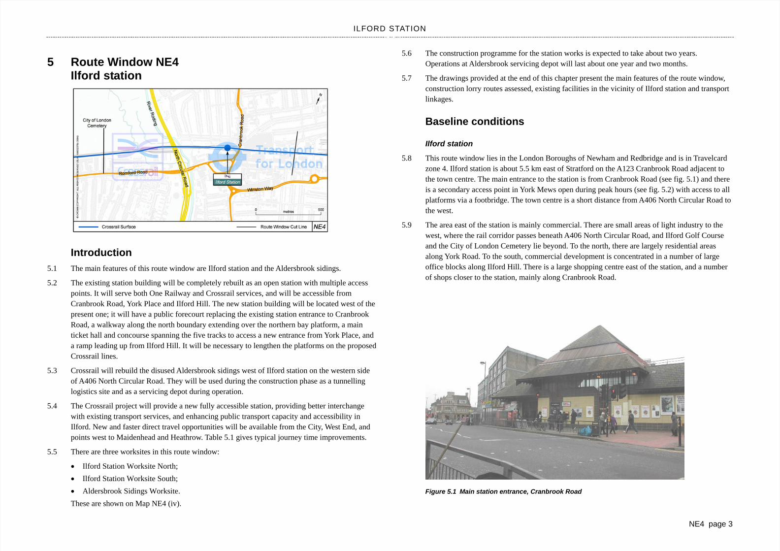
ILFORD STATION
NE4 page 3
5 Route Window NE4 Ilford station
Introduction5.1 The main features of this route window are Ilford station and the Aldersbrook sidings.
5.2 The existing station building will be completely rebuilt as an open station with multiple access points. It will serve both One Railway and Crossrail services, and will be accessible from Cranbrook Road, York Place and Ilford Hill. The new station building will be located west of the present one; it will have a public forecourt replacing the existing station entrance to Cranbrook Road, a walkway along the north boundary extending over the northern bay platform, a main ticket hall and concourse spanning the five tracks to access a new entrance from York Place, and a ramp leading up from Ilford Hill. It will be necessary to lengthen the platforms on the proposed Crossrail lines.
5.3 Crossrail will rebuild the disused Aldersbrook sidings west of Ilford station on the western side of A406 North Circular Road. They will be used during the construction phase as a tunnelling logistics site and as a servicing depot during operation.
5.4 The Crossrail project will provide a new fully accessible station, providing better interchange with existing transport services, and enhancing public transport capacity and accessibility in Ilford. New and faster direct travel opportunities will be available from the City, West End, and points west to Maidenhead and Heathrow. Table 5.1 gives typical journey time improvements.
5.5 There are three worksites in this route window:
Ilford Station Worksite North;
Ilford Station Worksite South;
Aldersbrook Sidings Worksite.
These are shown on Map NE4 (iv).
5.6 The construction programme for the station works is expected to take about two years. Operations at Aldersbrook servicing depot will last about one year and two months.
5.7 The drawings provided at the end of this chapter present the main features of the route window, construction lorry routes assessed, existing facilities in the vicinity of Ilford station and transport linkages.
Baseline conditions
Ilford station
5.8 This route window lies in the London Boroughs of Newham and Redbridge and is in Travelcard zone 4. Ilford station is about 5.5 km east of Stratford on the A123 Cranbrook Road adjacent to the town centre. The main entrance to the station is from Cranbrook Road (see fig. 5.1) and there is a secondary access point in York Mews open during peak hours (see fig. 5.2) with access to all platforms via a footbridge. The town centre is a short distance from A406 North Circular Road to the west.
5.9 The area east of the station is mainly commercial. There are small areas of light industry to the west, where the rail corridor passes beneath A406 North Circular Road, and Ilford Golf Course and the City of London Cemetery lie beyond. To the north, there are largely residential areas along York Road. To the south, commercial development is concentrated in a number of large office blocks along Ilford Hill. There is a large shopping centre east of the station, and a number of shops closer to the station, mainly along Cranbrook Road.
Figure 5.1 Main station entrance, Cranbrook Road
Transportfor London

ROUTE WINDOW NE4
NE4 page 4
5.10 Although Ilford station is a major public transport interchange in east London, providing connections with local bus services and regular rail services to Liverpool Street station. As a consequence of traffic congestion on both Ilford Hill and A123 Cranbrook Road, there is limited vehicular access to Ilford station. Cranbrook Road runs adjacent to the station entrance and has a pedestrian crossing outside the station, which deters drivers from stopping to drop passengers off and pick them up. Cranbrook Road is part of the proposed route of the East London Transit scheme.
Figure 5.2 Secondary ticket hall and access to the platforms, York Mews
5.11 Ilford station lies on the Great Eastern Main Line with services between Liverpool Street and Shenfield. Trains to Liverpool Street take between 12 and 15 minutes with a frequency of six trains per hour in the morning peak period. Eastbound trains to Shenfield take 26 minutes.
5.12 Ilford has a high level of bus services with 21 routes currently stopping within 400 metres of the station providing a total frequency of over 200 buses an hour in the morning peak period.
5.13 Balfour Road (opposite the station) has a taxi rank. This is 40 m away from the station entrance and is linked to the station by a pelican crossing on Cranbrook Road. High Road, which is slightly further from the station, also has a taxi rank. No signs were seen at the station to direct passengers to the taxi ranks. A minicab firm operates from premises on Ilford Hill, less than 5 minutes’ walk from the station.
5.14 Some metered on-street parking is available on York Road, which runs along the railway on its north side. There is no on-street parking on Cranbrook Road or Ilford Hill. There is no station car park, nor is there any other car park within 400 m of Ilford station that lends itself to commuter parking. Restrictions on length of stay prevent commuters from using local supermarket and
shopping centre car parks. All of Ilford’s off-street car parks are located to the south east of the town.
5.15 There are no cycle facilities at the station. Outside the station, there are six cycle racks within 30 m of the station forecourt on the other side of the road (near Balfour Road) and another six 80 m away on York Road. Neither set is secure or sheltered. There are several cycle routes accessing the station on Cranbrook Road. York Road and Thorold Road form part of the LCN route 55.
5.16 Pedestrian movement outside the station entrance is currently hindered by a news stand and market stalls. Otherwise, pedestrian facilities in the vicinity of the station are generally good.
5.17 There is mobility impaired passenger access at Ilford station.
Aldersbrook sidings
5.18 The Aldersbrook sidings site is an area of railway land west of Ilford station and A406 North Circular Road, between A118 Romford Road and the Great Eastern Main Line. It contains a number of railway sidings, some buildings formerly occupied by the now defunct College of Railway Technology and other derelict buildings. Some of the site is reverting to scrub.
Potential changes in baseline conditions
5.19 It is understood that Cranbrook Road lies on part of the route of the proposed East London Transit (ELT) scheme. This scheme does not form part of the baseline for Crossrail (see Volume 8a). If it were to be implemented, the scheme would be likely to have a significant beneficial impact along this corridor, and therefore on the assessment of the significance of Crossrail on this route. In the absence of firm proposals, it has not been possible to fully assess the implications of the relationship between the ELT scheme and Crossrail.
The permanent works
Ilford station
5.20 A new station building will be built to replace the existing building. The new building will be located west of the existing ticket hall, about half-way along the platforms. The new ticket hall will be directly accessible from the east off Cranbrook Road, the south from Ilford Hill and the north from York Road. The connecting footbridge opposite York Mews will no longer be necessary and will be removed. The new links to Ilford Hill and York Road will also facilitate north–south pedestrian flows helping to alleviating pedestrian congestion that occurs on Cranbrook Road.
5.21 The existing station will remain operational until the new ticket hall is opened.
5.22 The Crossrail-served platforms will have stairs, escalators and a lift to provide access for mobility impaired people between the ticket hall and the platform.
5.23 Crossrail will use platforms 3 and 4. To accommodate Crossrail trains, the island platforms 2/3 and 4/5 will be extended. The width of platform 4/5 will be increased to 5 m to accommodate the

ILFORD STATION
NE4 page 5
stairs and escalator. As a consequence, the track will have to be shifted northwards. The signalling and overhead line equipment will be adjusted to suit these changes.
5.24 New platform canopies and additional lighting will be provided, to extend along the whole length of the extended platforms. The platform furniture will be upgraded, with new seats and/or waiting shelters, as appropriate, and upgraded platform signs and CCTV coverage.
Aldersbrook sidings
5.25 The Aldersbrook sidings will be used during construction as a tunnelling logistics site serving the tunnel fit-out trains for the Central route section construction works. The works on the site will begin with the demolition of the derelict college buildings, after which the site will be cleared and prepared for the earthworks. The access from Lugg Approach may need to be strengthened for construction traffic where it crosses the Alders Brook.
5.26 The existing sidings will be largely left in their current positions. New loading sidings to the south of the existing sidings, on the site of the disused college buildings, will be provided. The new sidings will be used for loading materials on to, and removing waste from, the trains. When complete, the site will consist of six sidings, a widened embankment and a hard standing area.
5.27 Bi-directional working will be in operation as trains arrive at the sidings from the west and return in that direction, so a new crossover will be provided to allow them to cross lines as they enter the servicing depot. The crossover will be installed at a point east of Manor Park station (see Route Window NE3).
Worksite assessment (group 1) 5.28 This group of worksites comprises Ilford Station Worksite North, and Ilford Station Worksite
South. Both worksites share common lorry routes. The worksites and lorry routes are shown on Map NE4 (iv).
Ilford Station Worksite North
5.29 The northern worksite will be located in the narrow strip of land to the north of the station parallel to the railway at the rear of properties in York Road and adjacent to platform 5. At its eastern end, the site will extend as far as Cranbrook Road. At its western end, it will extend beyond the footbridge at the western extent of the station. To enable construction vehicles to reach this worksite, it will be necessary to demolish the secondary ticket hall building on York Mews (see fig. 5.2). The secondary ticket hall is open only during peak hours. Without the secondary ticket hall, the connecting footbridge to the platforms will be redundant and will therefore be removed.
5.30 There are three access points to the northern worksite. The second ticket hall on York Mews will be demolished to form the main access point. The second means of access will be formed between the garages on York Place. This will not require any demolition. Nos. 27–29 Cranbrook Road will be demolished to accommodate the new station building. Each of these access points will later provide permanent pedestrian access to the station.
Figure 5.3 Ilford Station Worksite North, access from York Mews
5.31 The site will have dedicated materials and excavated materials storage areas, car parking spaces and site facilities.
Ilford Station Worksite South
5.32 The southern worksite will be located alongside the Red Lion public house, 71 Ilford Hill (see fig. 5.4). Access will be via the present entrance from Ilford Hill eastbound. Ilford Hill operates as a one-way road.
5.33 The site will have dedicated materials and excavated materials storage areas, car parking spaces and site facilities.
5.34 It will be necessary to acquire the taxi office and the other structures on this site permanently. They will be demolished to create operational space on site. The use of this access route to the worksite by construction traffic is not predicted to give rise to any significant impacts on road users, pedestrians or cyclists.
5.35 It is expected that excavated and building material will be removed from the station worksites by road. Some construction plant and material will be transferred by rail from the Manor Park Station worksite (NE3).

ROUTE WINDOW NE4
NE4 page 6
Figure 5.4 Ilford Station Worksite South, access from Ilford Hill
Lorry routes assessment
5.36 The proposed lorry route (inbound) runs along the TLRN A406, Ilford Hill, Cranbrook Road, Beal Road, Belgrave Road, York Road and York Mews. Lorries leaving the site will be able to get back on to A406 via the Chapel Road one-way gyratory or to head towards A12 Gants Hill via York Mews, York Road and Cranbrook Road.
5.37 At present, traffic may not enter York Road from Cranbrook Road. Small vehicles will be able to access the northern and western worksites via Mill Road from Ilford Hill. There is a railway bridge over Mill Road with a height restriction of 3.66 m. Traffic signals enforce alternating single-lane operation on the road under the bridge.
5.38 It is likely that some construction deliveries will be made directly outside the station on Cranbrook Road.
5.39 Temporary parking restrictions may need to be introduced in parts of York Road and Cranbrook Road to allow construction traffic to move freely to the worksite and the delivery drop-off point. Detailed traffic management measures will need to be agreed with the London Borough of Redbridge.
5.40 The total number of lorry movements associated with works for Ilford station is approximately 1600. It is predicted that there will be about 34 two-way lorry movements a day for the estimated eight-week peak construction period: 20 to and from the northern/western worksite and 14 to and from the southern worksite. At other times the daily lorry movements will be about four at each of the sites.
5.41 No significant traffic-related impacts have been identified in this route window as a result of the estimated lorry movements or proposed lorry routes associated with works at Ilford station.
Worksite assessment (group 2) 5.42 This comprises a single worksite relating to the Aldersbrook sidings. The worksite and lorry
routes are shown on Map NE4 (iv).
Aldersbrook Sidings worksite
5.43 The Aldersbrook sidings are located behind a car showroom and a car workshop on A118 Romford Road close to A406 Ilford flyover. The sidings occupy the northern part of the worksite and the disused college buildings are on the southern side adjacent to the access from Lugg Approach. (See fig. 5.5.)
5.44 The site will have dedicated materials and excavated materials storage areas, car parking spaces and site facilities.
5.45 It is expected that excavated and building material will be removed from the site mainly by rail.
Figure 5.5 Disused buildings formerly occupied by the College of Railway Technology
Lorry routes assessment
5.46 The nearest road on the TLRN is A406, situated approximately 100 m east of the worksite. Lorries will access the Aldersbrook sidings worksite from A406 via A118 Romford Road and Lugg Approach. (See fig. 5.6.)

ILFORD STATION
NE4 page 7
Figure 5.6 Access to Aldersbrook sidings, Lugg Approach
5.47 It is estimated that this site will generate approximately two lorry movements a day over the construction period. However, the lorry movements will increase to 20 per day during the tunnel fit-out. This operation is likely to take about 12 months towards the end of the site activity.
5.48 No significant traffic and transportation impacts have been identified as a result of the lorry movements and proposed lorry route.
Mitigation and temporary impacts 5.49 Only one significant construction traffic impact is noted in Route Window NE4: passengers who
would have used the secondary ticket hall will have to walk another 250 m or thereabouts to the main station entrance on Cranbrook Road. A recent survey showed that, at present, over 600 passengers use the secondary ticket hall in the morning and 450 in the evening. The diversion will constitute a significant temporary impact, which will last for up to 12 months until the new station building is built and provides an access from York Road. The mitigation is reported in Table 5.2.
Mitigation and permanent impacts 5.50 The significant operational impacts and mitigation measures are indicated in Table 5.3. There is
one significant impact to note at Ilford relating to public transport.
5.51 Passenger numbers with Crossrail are expected to increase by about 1,900 passengers entering and 200 passengers leaving the station in the morning peak period (a 40 per cent increase two-way on the without Crossrail scenario). The 2016 with Crossrail flows predicted at the station are
about 7,400 two-way between 0700 and 1000 hours. The design of the new station building will provide sufficient capacity for the forecast passengers and will provide step-free access for mobility impaired passengers from street level to the Crossrail platforms. There may however be impacts on the local transport infrastructure in the vicinity of the station.
5.52 Traffic on Cranbrook Road is already very heavy and experiences congestion. Three links have been identified along Cranbrook Road that are forecast to experience significant increases in traffic flows during the morning peak hour. Firstly, Cranbrook Road between York Road and Wellesley Road. The traffic flow on this link is forecast at about 1500 vehicles two-way, an increase of eight per cent from the base flow of about 1400. Secondly, Cranbrook Road between York Road and Station Road. This is forecast to carry a flow of about 1400 vehicles two-way, an increase of seven per cent from the base flow of about 1300. The third link is Cranbrook Road between York Road and Wellesley Road. This will carry a flow of about 1800 vehicles two-way, an increase of 18 per cent from the base flow of about 1500.
5.53 There are measures that can be carried out for the benefit of road users and pedestrians that will mitigate these impacts; however, these will require further consents to be obtained before they can be implemented. In line with the approach set out in Volume 8a, an assessment of the impact of Crossrail has been carried out that assumes that such measures are in place.
5.54 Significant impacts on rail users at Ilford station are forecast. Rail passengers are forecast to experience significant journey time benefits. These are discussed below.
5.55 Although not included in the baseline scenario, the proposed East London Transit scheme has been taken account of in the development of the Crossrail proposals at Ilford. If the scheme were operational prior to Crossrail, it would be expected to reduce general traffic in the area
Impact on rail journey times
5.56 Table 5.1 sets out representative journey time savings between Ilford and selected stations. They are typical of the journey time benefits to many of the stations in the morning peak period onCrossrail.
Table 5.1 Journey savings (platform-to-platform) to and from Ilford station
From/to Heathrow Tottenham Court Road
Farringdon Canary Wharf
Without Crossrail 63 28 25 22
With Crossrail 56 20 17 19
Saving (minutes) 7 8 8 3 F
rom
Ilfo
rd
Saving (%) 11% 28% 32% 12%
Without Crossrail 55 32 27 26
With Crossrail 53 21 18 20
Saving (minutes) 2 11 9 6 To Il
ford
Saving (%) 4% 34% 32% 22%

ROUTE WINDOW NE4
NE4 page 8
Table 5.2 Route Window NE4 – Temporary impacts
Residual impact Works and potential impact Significance Committed mitigation
Description Significance
Vulnerable road user delay and loss of amenity
CT5b Closure of the secondary station ticketing hall and footbridge on York Mews will result in passengers having to access the main station entrance on Cranbrook Road. This will increase the passenger journey length by approximately 250 m.
Significant.Diversion route likely to exceed 250 m on a route carrying more than 200 pedestrians a day.
Appropriate signs to be installed indicating pedestrian diversion route along York Road.
Will remain significant until the new station building is complete. A new permanent secondary station access will be available to access the station from York Road via York Place at that time.
Significant.
Table 5.3 Route Window NE4 – Permanent impacts
Residual impact Potential impact Significance Committed mitigation
Description Significance
Station impacts
OT5 Significant increase (+40%) in passenger movements during the morning peak period: about 1,900 more passengers entering the station and about 200 more leaving
Significant An appropriate package of mitigation measures will be developed in due course to address pedestrian and highway impacts. This package will require further consents to be obtained. Please refer to 5.53.
N/a Non-significant
Traffic levels on Cranbrook Road
OT1b Cranbrook Road, between York Road and Wellesley Road, 8 per cent increase in traffic to about 1500 vehicles, two-way in the morning peak hour
Significant An appropriate package of mitigation measures will be developed in due course to address pedestrian and highway impacts. This package will require further consents to be obtained. Please refer to 5.53.
N/a Non-significant
OT1b Cranbrook Road, between York Road and Station Road, 7 per cent increase in traffic to about 1400 vehicles, two-way in the morning peak hour
Significant An appropriate package of mitigation measures will be developed in due course to address pedestrian and highway impacts. This package will require further consents to be obtained. Please refer to 5.53.
N/a Non-significant
OT1b Cranbrook Road, between High Road and Station Road, 18 per cent increase in traffic to about 1800 vehicles, two-way in the morning peak hour
Significant An appropriate package of mitigation measures will be developed in due course to address pedestrian and highway impacts. This package will require further consents to be obtained. Please refer to 5.53.
N/a Non-significant
Public transport
OT2c Improved journey time– see journey times table Significant N/a N/a Significant

Transportfor London
Transportfor London
Transportfor London


Transportfor London
Transportfor London
Transportfor London


Transportfor London
Transportfor London
Transportfor London
