chapter 4: land uses current conditions -...
TRANSCRIPT
Comprehensive Plan of the Town of Torrey
Prepared by Genesee/Finger Lakes Regional Planning Council 19
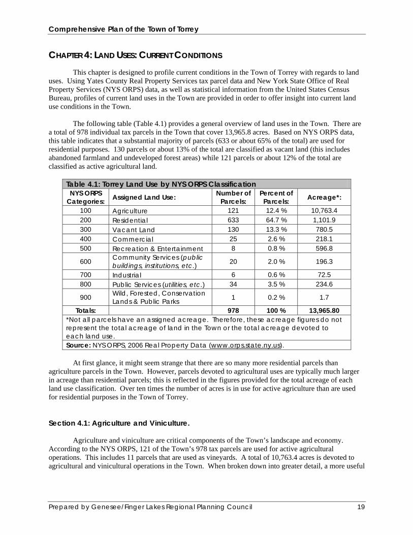
CCHHAAPPTTEERR 44:: LLAANNDD UUSSEESS:: CCUURRRREENNTT CCOONNDDIITTIIOONNSS This chapter is designed to profile current conditions in the Town of Torrey with regards to land uses. Using Yates County Real Property Services tax parcel data and New York State Office of Real Property Services (NYS ORPS) data, as well as statistical information from the United States Census Bureau, profiles of current land uses in the Town are provided in order to offer insight into current land use conditions in the Town. The following table (Table 4.1) provides a general overview of land uses in the Town. There are a total of 978 individual tax parcels in the Town that cover 13,965.8 acres. Based on NYS ORPS data, this table indicates that a substantial majority of parcels (633 or about 65% of the total) are used for residential purposes. 130 parcels or about 13% of the total are classified as vacant land (this includes abandoned farmland and undeveloped forest areas) while 121 parcels or about 12% of the total are classified as active agricultural land.
Table 4.1: Torrey Land Use by NYS ORPS Classification NYS ORPS
Categories: Assigned Land Use: Number of Parcels:
Percent of Parcels: Acreage*:
100 Agriculture 121 12.4 % 10,763.4 200 Residential 633 64.7 % 1,101.9 300 Vacant Land 130 13.3 % 780.5 400 Commercial 25 2.6 % 218.1 500 Recreation & Entertainment 8 0.8 % 596.8
600 Community Services (public buildings, institutions, etc.) 20 2.0 % 196.3
700 Industrial 6 0.6 % 72.5 800 Public Services (utilities, etc.) 34 3.5 % 234.6
900 Wild, Forested, Conservation Lands & Public Parks 1 0.2 % 1.7
Totals: 978 100 % 13,965.80 *Not all parcels have an assigned acreage. Therefore, these acreage figures do not represent the total acreage of land in the Town or the total acreage devoted to each land use. Source: NYS ORPS, 2006 Real Property Data (www.orps.state.ny.us).
At first glance, it might seem strange that there are so many more residential parcels than agriculture parcels in the Town. However, parcels devoted to agricultural uses are typically much larger in acreage than residential parcels; this is reflected in the figures provided for the total acreage of each land use classification. Over ten times the number of acres is in use for active agriculture than are used for residential purposes in the Town of Torrey. Section 4.1: Agriculture and Viniculture. Agriculture and viniculture are critical components of the Town’s landscape and economy. According to the NYS ORPS, 121 of the Town’s 978 tax parcels are used for active agricultural operations. This includes 11 parcels that are used as vineyards. A total of 10,763.4 acres is devoted to agricultural and vinicultural operations in the Town. When broken down into greater detail, a more useful

Comprehensive Plan of the Town of Torrey
Prepared by Genesee/Finger Lakes Regional Planning Council 20
picture of agriculture and viniculture in the Town emerges. Table 4.2 (following page) provides additional details on agricultural uses in the Town: Table 4.2: Parcels in Agricultural Production (NYS ORPS Category 100) NYS ORPS Subcategory: Number of
Parcels:
105: Agricultural Vacant Land (productive land that is part of a working farm) 32 112: Dairy Products (milk, butter, cheese) 27 113: Cattle, Calves, Hogs 4 117: Horse Farms 2 120: Field Crops (Potatoes, wheat, hay, dry beans, corn, oats, etc.) 32 140: Truck Crops (nonmuckland used to grow onions, snap beans, tomatoes, etc.) 13 152: Vineyards 11
Total number of category 100 parcels: 121 Percentage of the total number of parcels in the town: 12.4 % Source: NYS ORPS, 2006 Real Property Data (www.orps.state.ny.us).
Table 4.2 indicates that most agricultural parcels in the Town are used for field crops such as wheat and corn as well as dairying. A large number of agricultural parcels are currently vacant, although they are part of active farms and could be put back into production at any time. Many local farms are operated by members of the Mennonite community, which provides critical support for working agriculture in the Town. There are eleven parcels devoted to vineyards in the Town. Local wineries that operate vineyards wholly or partially in the Town include Fox Run Vineyards, Red Tail Ridge Winery, Anthony Road Wine Company, Prejean Winery, Torrey Ridge Winery, Seneca Shores Winery, and Earle Estates Winery and Meadery. Taking advantage of the moderating influence of Seneca Lake’s microclimate for grape production, these wineries are also a critical support for the local and regional economy and a major draw for tourists from throughout the United States.

Comprehensive Plan of the Town of Torrey
Prepared by Genesee/Finger Lakes Regional Planning Council 21
Figure 4.1: This dairy farm along the Route 14 spur in Torrey is typical of the farming operations
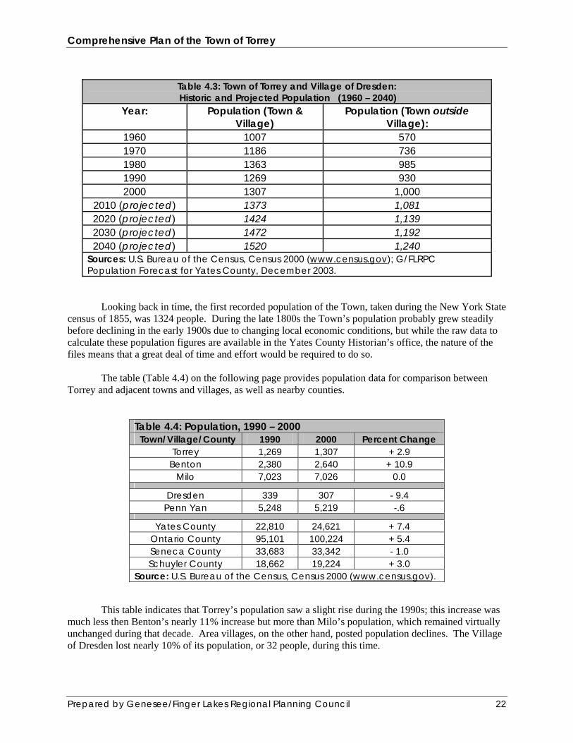
found within the Town. Section 4.2: Local Demographics and Economy.* Municipal land uses are profoundly impacted by local demographic and economic conditions. The needs and interests of different age and economic groups exert a powerful influence over the rate of new development, the re-development of existing properties; the demands placed on public services such as utilities, emergency response, and educational institutions; and interest in recreational opportunities. This section of the Comprehensive Plan is designed to provide readers with a general overview of demographic and economic conditions in the Town of Torrey. The following table (Table 4.3) provides some statistical data on overall population levels. The Town posted a population of 1307 people at the 2000 Census, and that figure is projected to gradually but steadily grow over the next several decades. Generally, the Town’s population has steadily grown since at least 1960, when it stood at just over 1000. There was a slight downturn during the 1980s, when the Town’s population fell from 985 to 930, but since then it has rebounded and is projected to continue rising over the next several decades.
Comprehensive Plan of the Town of Torrey
Prepared by Genesee/Finger Lakes Regional Planning Council 22
Table 4.3: Town of Torrey and Village of Dresden: Historic and Projected Population (1960 – 2040)
Year: Population (Town & Village)
Population (Town outside Village):
1960 1007 570 1970 1186 736 1980 1363 985 1990 1269 930 2000 1307 1,000
2010 (projected) 1373 1,081 2020 (projected) 1424 1,139 2030 (projected) 1472 1,192 2040 (projected) 1520 1,240
Sources: U.S. Bureau of the Census, Census 2000 (www.census.gov); G/FLRPC Population Forecast for Yates County, December 2003.
Looking back in time, the first recorded population of the Town, taken during the New York State census of 1855, was 1324 people. During the late 1800s the Town’s population probably grew steadily before declining in the early 1900s due to changing local economic conditions, but while the raw data to calculate these population figures are available in the Yates County Historian’s office, the nature of the files means that a great deal of time and effort would be required to do so. The table (Table 4.4) on the following page provides population data for comparison between Torrey and adjacent towns and villages, as well as nearby counties.
Table 4.4: Population, 1990 – 2000 Town/Village/County 1990 2000 Percent Change
Torrey 1,269 1,307 + 2.9 Benton 2,380 2,640 + 10.9
Milo 7,023 7,026 0.0
Dresden 339 307 - 9.4 Penn Yan 5,248 5,219 -.6
Yates County 22,810 24,621 + 7.4 Ontario County 95,101 100,224 + 5.4 Seneca County 33,683 33,342 - 1.0 Schuyler County 18,662 19,224 + 3.0
Source: U.S. Bureau of the Census, Census 2000 (www.census.gov). This table indicates that Torrey’s population saw a slight rise during the 1990s; this increase was much less then Benton’s nearly 11% increase but more than Milo’s population, which remained virtually unchanged during that decade. Area villages, on the other hand, posted population declines. The Village of Dresden lost nearly 10% of its population, or 32 people, during this time.

Comprehensive Plan of the Town of Torrey
Prepared by Genesee/Finger Lakes Regional Planning Council 23
The following table (Table 4.5) provides some basic information on age distribution in Torrey and other nearby municipalities. About 30% of the Town’s population is 19 and under, a figure which is roughly equal to all nearby municipalities. However, the Town’s population of people 65 and older is about 15%, somewhat less than nearby municipalities.
Table 4.5: Age Distribution, 2000
Town/Village/County Percent of
Population 19 and Under
Percent of Population 65 and
Over Torrey 29.2 14.9
Benton 30.3 19.4 Milo 28.8 17.5
Dresden 23.4 16.3 Penn Yan 26.3 21.7
Yates County 30.4 15.5 Ontario County 28.1 13.2 Seneca County 26.9 15.1 Schuyler County 28.3 14.6
Source: U.S. Bureau of the Census, Census 2000 (www.census.gov).
The following table (Table 4.6) provides additional details about the ages of the Town’s
population by breaking down the age structure of the Town’s population into a series of age brackets. In the year 2000, out of a total population of 1307, there were 670 males and 637 females living in Torrey. The median age of the Town’s population is 41.2 years.
Table 4.6: Age Brackets, 2000 Age: Number: Percent:
Under 5 years 73 5.6 % 5 to 9 years 97 7.4 % 10 to 14 years 101 7.7 % 15 to 19 years 111 8.5 % 20 to 24 years 51 3.9 % 25 to 34 years 118 9.0 % 35 to 44 years 167 12.8 % 45 to 54 years 197 15.1 % 55 to 64 years 197 15.1 % 65 to 74 years 114 8.7 % 75 to 84 years 61 4.7 % 85 years and older 20 1.5 % Total: 1,307 100.0 % Source: U.S. Bureau of the Census, Census 2000 (www.census.gov).
Shifting focus to educational attainment, the following table (Table 4.7) provides information on
basic educational levels among the Town’s residents. As compared to its neighboring towns, Torrey has the lowest percentage of population that graduated high school. About 75% of the Town’s population has

Comprehensive Plan of the Town of Torrey
Prepared by Genesee/Finger Lakes Regional Planning Council 24
completed high school, which falls slightly below the rates in Milo and Benton, both of which are about 78%. It also falls below the Yates County rate of 80.0%. When compared to its neighboring towns, Torrey also has the lowest percentage of residents with a bachelor’s degree or higher (about 14%). However, this percentage is still higher than the Village of Dresden, which recorded that only about 8% of its population holds a Bachelor’s degree or higher.
Table 4.7: Educational Attainment, 2000
Town/Village/County Percent of Population
with a High School Diploma or Higher
Percent of Population with a Bachelor’s Degree or Higher
Torrey 74.6 % 13.9 % Milo 78.1 % 16.7 %
Benton 77.8 % 17.5 %
Dresden 66.9 % 8.3 % Penn Yan 76.0 % 14.7 %
Yates County 80.0 % 18.2 % Ontario County 87.4 % 24.7 % Seneca County 79.1 % 17.5 % Schuyler County 82.4 % 15.5 %
Source: U.S. Bureau of the Census, Census 2000 (www.census.gov).
Table 4.8 below provides a basic overview of income and poverty levels in the Town. Torrey has
the fewest number of families living in the Town as compared to neighboring towns. Its median family income in 1999, at $ 40,350, places it squarely in the middle of the comparison towns in regards to median family income. It is slightly below the median family income of Yates County as a whole, which is at $40,681.
Table 4.8: Family Income and Poverty, 2000
Town/Village/County Number of Families
Median Family
Income in 1999
Percentage of Families Below the Poverty Level
Torrey 327 $ 40,350 7.6 % Milo 1,817 $ 38,547 9.6 %
Benton 657 $ 43,988 7.5 %
Dresden 83 $ 40,208 4.8 % Penn Yan 1,264 $ 39,087 9.7 %
Yates County 6,316 $ 40,681 8.9 % Ontario County 26,537 $ 52,698 4.9 % Seneca County 8,628 $ 45,445 8.0 % Schuyler County 5,204 $ 41,441 8.8 %
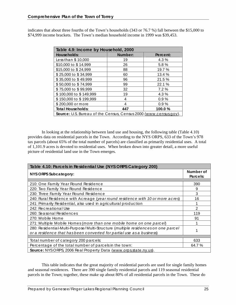
Source: U.S. Bureau of the Census, Census 2000 (www.census.gov). The following table (Table 4.9) provides income data by household in the Town. This table
Comprehensive Plan of the Town of Torrey
Prepared by Genesee/Finger Lakes Regional Planning Council 25
indicates that about three fourths of the Town’s households (343 or 76.7 %) fall between the $15,000 to $74,999 income brackets. The Town’s median household income in 1999 was $39,453.
Table 4.9: Income by Household, 2000 Households: Number: Percent: Less than $ 10,000 19 4.3 % $10,000 to $ 14,999 26 5.8 % $15,000 to $ 24,999 88 19.7 % $ 25,000 to $ 34,999 60 13.4 % $ 35,000 to $ 49,999 96 21.5 % $ 50,000 to $ 74,999 99 22.1 % $ 75,000 to $ 99,999 32 7.2 % $ 100,000 to $ 149,999 19 4.3 % $ 150,000 to $ 199,999 4 0.9 % $ 200,000 or more 4 0.9 % Total Households: 447 100.0 % Source: U.S. Bureau of the Census, Census 2000 (www.census.gov).
In looking at the relationship between land use and housing, the following table (Table 4.10) provides data on residential parcels in the Town. According to the NYS ORPS, 633 of the Town’s 978 tax parcels (about 65% of the total number of parcels) are classified as primarily residential uses. A total of 1,101.9 acres is devoted to residential uses. When broken down into greater detail, a more useful picture of residential land use in the Town emerges. Table 4.10: Parcels in Residential Use (NYS ORPS Category 200) NYS ORPS Subcategory: Number of
Parcels:
210: One Family Year Round Residence 390 220: Two Family Year Round Residence 9 230: Three Family Year Round Residence 3 240: Rural Residence with Acreage (year round residence with 10 or more acres) 16 241: Primarily Residential, also used in agricultural production 1 242: Recreational Use 2 260: Seasonal Residences 119 270: Mobile Home 91 271: Multiple Mobile Homes (more than one mobile home on one parcel) 1 280: Residential-Multi-Purpose/Multi-Structure (multiple residences on one parcel or a residence that has been converted for partial use as a business) 1
Total number of category 200 parcels: 633 Percentage of the total number of parcels in the town: 64.7 % Source: NYS ORPS, 2006 Real Property Data (www.orps.state.ny.us).
This table indicates that the great majority of residential parcels are used for single family homes and seasonal residences. There are 390 single family residential parcels and 119 seasonal residential parcels in the Town; together, these make up about 80% of all residential parcels in the Town. These do
Comprehensive Plan of the Town of Torrey
Prepared by Genesee/Finger Lakes Regional Planning Council 26
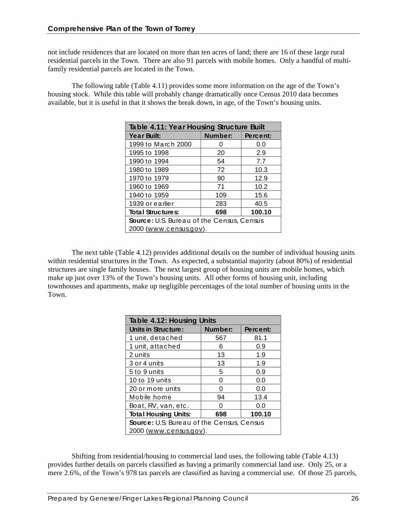
not include residences that are located on more than ten acres of land; there are 16 of these large rural residential parcels in the Town. There are also 91 parcels with mobile homes. Only a handful of multi-family residential parcels are located in the Town. The following table (Table 4.11) provides some more information on the age of the Town’s housing stock. While this table will probably change dramatically once Census 2010 data becomes available, but it is useful in that it shows the break down, in age, of the Town’s housing units.
Table 4.11: Year Housing Structure Built Year Built: Number: Percent: 1999 to March 2000 0 0.0 1995 to 1998 20 2.9 1990 to 1994 54 7.7 1980 to 1989 72 10.3 1970 to 1979 90 12.9 1960 to 1969 71 10.2 1940 to 1959 109 15.6 1939 or earlier 283 40.5 Total Structures: 698 100.10 Source: U.S. Bureau of the Census, Census 2000 (www.census.gov).
The next table (Table 4.12) provides additional details on the number of individual housing units within residential structures in the Town. As expected, a substantial majority (about 80%) of residential structures are single family houses. The next largest group of housing units are mobile homes, which make up just over 13% of the Town’s housing units. All other forms of housing unit, including townhouses and apartments, make up negligible percentages of the total number of housing units in the Town.
Table 4.12: Housing Units Units in Structure: Number: Percent: 1 unit, detached 567 81.1 1 unit, attached 6 0.9 2 units 13 1.9 3 or 4 units 13 1.9 5 to 9 units 5 0.9 10 to 19 units 0 0.0 20 or more units 0 0.0 Mobile home 94 13.4 Boat, RV, van, etc. 0 0.0 Total Housing Units: 698 100.10 Source: U.S. Bureau of the Census, Census 2000 (www.census.gov).
Shifting from residential/housing to commercial land uses, the following table (Table 4.13) provides further details on parcels classified as having a primarily commercial land use. Only 25, or a mere 2.6%, of the Town’s 978 tax parcels are classified as having a commercial use. Of those 25 parcels,

Comprehensive Plan of the Town of Torrey
Prepared by Genesee/Finger Lakes Regional Planning Council 27
this table indicates that they are fairly evenly broken down among a wide variety of disparate commercial uses. Table 4.13: Parcels in Commercial Use (NYS ORPS Category 400)
NYS ORPS Subcategory: Number of Parcels:
411: Apartments 1 421: Restaurants 1 422: Diners and Luncheonettes 1 423: Snack Bars, Drive-Ins, Ice Cream Bars 1 431: Auto Dealers – Sales and Service 1 432: Service and Gas Stations 2 440: Storage, Warehouse and Distribution Facilities 2 442: Mini-Warehouse (Self Service Storage) 1 444: Lumber Yards, Sawmills 1 449: Other Storage, Warehouse and Distribution Facilities 8 470: Miscellaneous Services 3 484: One Story Small Structure (one occupant building adaptable for several uses) 2 486: Minimart 1
Total number of category 400 parcels: 25 Percentage of the total number of parcels in the town: 2.6 % Source: NYS ORPS, 2006 Real Property Data (www.orps.state.ny.us).
Tables 4.14 and 4.15 provide detailed information on the Town’s civilian workforce. Table 4.14 breaks down the Town’s employed population by what industries people work in. Table 4.15 breaks down the employed population by what broad occupational categories people work in.
These tables indicate that while agricultural operations play an important role in the Town’s
economic life, most of the Town’s inhabitants do not draw their living directly from the land. Many residents support themselves and their families through a broad variety of professions and industries. Approximately one fourth (24.5%) of the Town’s employed population work in the education, health, and social service fields. About 16% of the Town’s employed population work in agriculture and agriculture-related fields, while about 15% work in manufacturing.

Comprehensive Plan of the Town of Torrey
Prepared by Genesee/Finger Lakes Regional Planning Council 28
Table 4.14: Employed Civilian Population (16 years and over) by Industry Industry: Number: Percent: Agriculture, forestry, fishing and hunting, mining 97 16.1 % Construction 57 9.5 % Manufacturing 91 15.1 % Wholesale Trade 15 2.5 % Retail Trade 46 7.7 % Transportation and warehousing, utilities 44 7.3 % Information 2 0.3 % Finance, insurance, real estate, and rental and leasing 10 1.7 % Professional, scientific, management, administrative, and
waste management services 24 4.0 %
Education, health, and social services 147 24.5 % Arts, entertainment, recreation, accommodation, 23 3.8 % Other services (except public administration) 26 4.3 % Public Administration 19 3.2 % Total Employed Civilian Population (16 years and over) 601 100.0 % Source: U.S. Bureau of the Census, Census 2000 (www.census.gov).
Table 4.15: Employed Civilian Population (16 years and over) by Occupation Occupation: Number: Percent: Management, Professional, and related occupations 178 29.6 % Service occupations 84 14.0 % Sales and office occupations 105 17.5 % Farming, fishing, and forestry occupations 49 8.2 % Construction, extraction, and maintenance occupations 84 14.0 % Production, transportation, and material moving occupations 101 16.8 % Total Employed Civilian Population (16 years and over) 601 100.10* % *The .10% difference between 100.10% and 100% is due to rounding error. Source: U.S. Bureau of the Census, Census 2000 (www.census.gov).
*Much of this section is based on statistical data culled from the results of the 2000 census. Once the results of the 2010 census become available, the Town Planning Board should update these tables and their associated commentary. Section 4.3: Natural Resources. In addition to its valuable farmland (see above, Section 4.1), the Town of Torrey has the advantage of ready access to a number of significant natural resources that contribute to both the aesthetic appeal of the area and the viability of the local economy. The Town should work to ensure the continued stability of these critical resources. 1.) Seneca Lake. Seneca Lake is the largest of New York’s eleven Finger Lakes when measured in volume (estimated at 4.2 trillion gallons of water). This volume represents about 50% of the volume of water in all eleven lakes! The lake is 35.1 miles long and 3.2 miles wide at its widest point, although its average

Comprehensive Plan of the Town of Torrey
Prepared by Genesee/Finger Lakes Regional Planning Council 29
width is 1.9 miles. Its maximum depth is 651 feet, although its average depth is 290 feet. The lake’s surface area is 66.3 square miles/175 square kilometers (about 42,400 acres). The total shoreline of the lake is about 75 miles long. Winter lake levels range between 445 plus or minus 0.3 feet. Summer lake levels range between 446 plus or minus 0.3 feet. Flood stage is 448 feet. The immense quantity of water stored in the lake is important for several reasons: 1.) it allows the lake to hold and dissipate heat, thus creating a unique “microclimate” that supports agricultural practices that would otherwise be untenable; 2.) it supplies water for drinking, irrigation, and manufacturing purposes; 3.) it dilutes and neutralizes pollutants such as sewage effluents, fertilizers and pesticides, industrial discharges, and septic tank seepages; and 4.) it offers a good spawning ground for fish.
Figure 4.2: A view looking north over Seneca Lake. The smokestacks of the AES power plant are
clearly visible in the center of the image. The Village of Dresden sits just left of the smokestacks. The Town of Torrey is concerned about protecting key natural resources such as the lake’s water quality.
There are twenty-nine “sub-watersheds” within the Seneca Lake watershed. In addition to numerous small streams that flow into the lake from the surrounding slopes, the lake has three main sources of water: two large streams, which are Catharine Creek and the Keuka Outlet, and underwater springs. Catharine Creek, which drains about a quarter of the lake’s watershed, is located at the southern end of the lake. The Keuka Outlet flows through Torrey and enters the lake just north of its north/south midpoint. The springs feed water into the lake and keep the lake water constantly circulating, which prevents it from freezing over. Torrey is one of forty (40) municipalities (towns, villages, and cities) that are located wholly or partially in the vast Seneca Lake watershed. The watershed includes portions of five counties: Yates, Ontario, Seneca, Schuyler, and Chemung. These numerous jurisdictional divisions can be challenging to

Comprehensive Plan of the Town of Torrey
Prepared by Genesee/Finger Lakes Regional Planning Council 30
individuals and organizations that are working for a coordinated, watershed-wide approach to land management and environmental issues.* *Please refer to the report entitled “Setting a Course for Seneca Lake: The State of the Seneca Lake Watershed 1999” for more information regarding Seneca Lake and its watershed. The Town owns a small lakefront park that includes a swimming beach and picnic area; this park is located within the Village of Dresden. The Town also owns several rights-of-way leading down to the lake; these old roads once ended at docks where steamboats tied up to take on loads of grapes and various other local agricultural products for shipment to lake ports such as Geneva.
Figure 4.3: A view from the lake of the Town’s lakefront park. This park features a swimming area,
beach, and picnic areas. Like all the other municipalities surrounding the lake, Torrey has a responsibility to protect and enhance the lake’s water quality. Human activities can exert a profound influence over water quality in lakes and streams and the Town should work to reduce the runoff of sediments and pollutants into the lake. In addition to the lake itself, much of the Town’s shoreline should be considered a valuable natural resource due to its geological formations and the shoreline’s role in providing local wildlife with unique niche habitats. 2.) The Keuka Outlet and the Keuka Outlet Trail.
Comprehensive Plan of the Town of Torrey
Prepared by Genesee/Finger Lakes Regional Planning Council 31
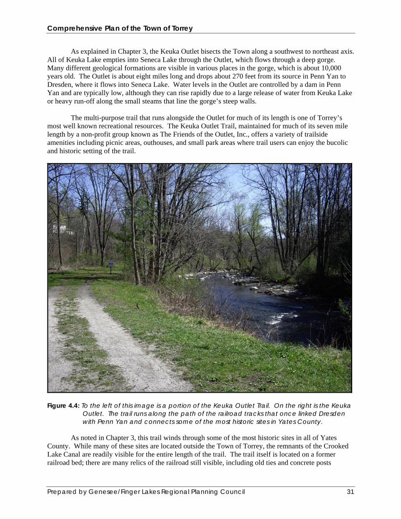
As explained in Chapter 3, the Keuka Outlet bisects the Town along a southwest to northeast axis. All of Keuka Lake empties into Seneca Lake through the Outlet, which flows through a deep gorge. Many different geological formations are visible in various places in the gorge, which is about 10,000 years old. The Outlet is about eight miles long and drops about 270 feet from its source in Penn Yan to Dresden, where it flows into Seneca Lake. Water levels in the Outlet are controlled by a dam in Penn Yan and are typically low, although they can rise rapidly due to a large release of water from Keuka Lake or heavy run-off along the small steams that line the gorge’s steep walls. The multi-purpose trail that runs alongside the Outlet for much of its length is one of Torrey’s most well known recreational resources. The Keuka Outlet Trail, maintained for much of its seven mile length by a non-profit group known as The Friends of the Outlet, Inc., offers a variety of trailside amenities including picnic areas, outhouses, and small park areas where trail users can enjoy the bucolic and historic setting of the trail.
Figure 4.4: To the left of this image is a portion of the Keuka Outlet Trail. On the right is the Keuka
Outlet. The trail runs along the path of the railroad tracks that once linked Dresden with Penn Yan and connects some of the most historic sites in Yates County.
As noted in Chapter 3, this trail winds through some of the most historic sites in all of Yates County. While many of these sites are located outside the Town of Torrey, the remnants of the Crooked Lake Canal are readily visible for the entire length of the trail. The trail itself is located on a former railroad bed; there are many relics of the railroad still visible, including old ties and concrete posts

Comprehensive Plan of the Town of Torrey
Prepared by Genesee/Finger Lakes Regional Planning Council 32
marked with a “W” that alerted the locomotive engineer to sound his whistle as the train approached a crossing. 3.) Scenic Viewsheds. Like most, if not all, towns in the Finger Lakes region, Torrey enjoys several unparalleled scenic vistas that offer views of both the countryside and Seneca Lake. Sweeping panoramas of hills, forests, fields and lakes are a defining feature of life in the Finger Lakes and area municipalities should actively work both to protect these resources as well as highlight them in their land use plans and regulations. The Yates County Looking Ahead report, issued in 1990, identified two “scenic viewsheds” in the Town. One is the Travis Road Scenic District, which offers views looking eastward out over Seneca Lake and nearby farmland; the other is the Torrey Scenic Corridor, which runs along Route 14 in the southern part of the Town and offers spectacular views of the lake and countryside. The Town should identify these, and/or other, viewsheds as natural resources worthy of protection.
Figure 4.5: One of the most impressive scenic vistas in the Town is this view looking north out over
Seneca Lake. Route 14 runs upward from the left of the image; the smokestacks of the AES power plant are clearly visible left of center. The Village of Dresden sits just left of the smokestacks. The Town is concerned about protecting views such as this one which include many of the traditional elements found in Finger Lakes landscapes, including farm fields and agricultural buildings, forested areas, and broad expanses of water.
4.) Woodlots.

Comprehensive Plan of the Town of Torrey
Prepared by Genesee/Finger Lakes Regional Planning Council 33
Most of the Torrey’s land cover is devoted to agricultural operations. However, substantial stands of mature trees are located throughout the Town, especially in areas near the Keuka Outlet and in the southeast area of the Town on the slopes above Seneca Lake. These woodlots are valuable for a variety of reasons, ranging from their aesthetic appeal to their harboring of local wildlife to their role in preventing soil from eroding into local streams and the lake. While farmers should be able to clear woodlots in order to expand their farming operations, both the agricultural community and other residents should seek to protect and preserve these wooded areas wherever and whenever possible. 5.) Natural and Historic Sites. While not a natural resource per se, the Town’s historic sites are an important aspect of the local landscape. The following natural and historic resources were identified in the Yates County Looking Ahead study: 1. Olney-Ryal Cobblestone House (1835), Route 14. 2. Youngs-Leach Cobblestone House (1836), Route 14 3. Keuka Lake Outlet trail and millsites. 4. Nutt farm (1820s), Nutt Road. 5. Whitaker Farm (c. 1800), Townline Road. 6. City Hill Cemetery (1789-present), City Hill Road. 7. Bruce’s Gully (flows into the Keuka Outlet). 8. Harris Flats and Indian burial ground, Dresden along Outlet. 9. Kalorama (1849), Route 54. 10. Hopeton Mill foundations (1794), Outlet at Hopeton Road. Where possible, the Town of Torrey should work to protect and preserve these sites, buildings, and structures from poorly considered development and land uses that could harm them. Section 4.4: Transportation. The Town of Torrey is served by a fairly dense network of local and State roads. According to the Yates County Highway Department, there are a total of 53.13 miles of public roads in the Town. 11.05 miles of these roads are under the New York State Department of Transportation’s (NYS DOT) jurisdiction. Of the remaining 42.08 miles of local roads, 13.41 miles are under Yates County’s jurisdiction. The other 28.67 miles of roads are maintained by the Town through its Highway Department.

Comprehensive Plan of the Town of Torrey
Prepared by Genesee/Finger Lakes Regional Planning Council 34
Figure 4.6: Most local roads in the Town of Torrey are similar to Anthony Road, seen above in a
view looking east over Seneca Lake. Roads under State jurisdiction include the two main highways in the Town: Routes 14 and 54. Route 14 provides the most direct link north to Geneva and the New York State Thruway and south to Watkins Glen and Horseheads, while Route 54 provides the best link west to Penn Yan. County roads located wholly or partially in the Town include Anthony Beach Road (County Road 3), Flynn Road (County Road 7), Ridge Road (County Road 9), Havens Corners Road (County Road 14), Travis Road (County Road 16), City Hill Road (County Road 26), and Leach Road (County Road 28). NYS DOT traffic counts conducted on county roads in the Town in October 2005 indicate that Ridge Road is the most heavily traveled County road in the Town.
The principle north/south road in the Town is Route 14, which runs south from the Torrey/Benton town line, curves to the southeast, skirts the Village of Dresden, and continues due south to the Torrey/Milo town line. Other north/south roads in the Town include Ridge Road, Swarthout Road, Hazard Road, and Norris Road. Most roads in the Town run east to west; these routes include Travis Road, Larzellere Road, Nutt Road, State Route 54, City Hill Road, and Leach Road.
In addition to these main roadways, numerous short and narrow roads provide access to lakefront
properties. Most of these roads are private roads and the Town does not maintain them. The principle form of transportation within the Town is by private automobile; no public
transportation services are currently available either in the Town or within Yates County. However, the Mennonite population typically relies on horse-drawn carriages and bicycles for transportation around Town; these vehicles are a common sight along the Town’s roads. Future transportation planning initiatives should include provisions for accommodating this form of transport. Travel modes such as biking, hiking, and skiing are widely used throughout the Town for recreational purposes.
The following table (Table 4.16) provides some basic statistical data about commuters in Torrey.
According to this table, almost 75% of the Town’s commuters rely on a car, truck or van that they drive
Comprehensive Plan of the Town of Torrey
Prepared by Genesee/Finger Lakes Regional Planning Council 35
themselves to get to work. A sizable minority, about 13%, carpool. Only a tiny percentage of the Town’s commuters use some form of public transportation or walk to get to work. About 8.5% of commuters have perhaps the ideal commute: they reported that they work out of their homes.
Table 4.16: Commuting to Work (Workers 16 years and over) Means of Commute: Number: Percent: Car, truck, or van – drove alone 416 72.3 % Car, truck, or van – carpooled 74 12.9 % Public Transportation (inc. taxicab) 3 0.5 % Walked 20 3.5 % Other means 13 2.3 % Worked at home 49 8.5 % Totals: 575 100.0 % Mean travel time to work (minutes) 25.3 N/A Source: U.S. Bureau of the Census, Census 2000 (www.census.gov).
According to the Town Highway Superintendent, key issues regarding local roads that should be
addressed by the Comprehensive Plan, and especially by any Capital Improvement Plan (CIP) that the Town develops, include: widening roads and road shoulders to a width of 20 to 22 feet (where possible due to right-of-way restrictions); upgrading drainage ditches to be able to handle 25 to 50 year storm events; coordinating with NYS DOT to address safety concerns at certain intersections of local (town and county) roads with the state highways in town; installing more reflective signs around the town to improve night-time visibility of these signs, and building turnarounds on the end of dead-end town roads to better accommodate snow plows and emergency vehicles such as fire trucks and ambulances. Section 4.5: Municipal Government and Public Services. The structure of Town Government is set out by State Law. The Town of Torrey is governed by a Town Board, which consists of five members: the Town Supervisor and four Councilmen/women. The Town Board is the legislative body responsible for governing the Town by setting official Town policy regarding any issue that involves the Town’s interests, overseeing the budget process and allocating resources towards selected projects, and by passing and amending local laws and ordinances. Land use issues in the Town are overseen ultimately by the Town Board, but the Town Planning Board and the Zoning Board of Appeals (ZBA) are the two boards that handle the day-to-day administration and implementation of the Town’s Comprehensive Plan and zoning law. The Planning Board handles long-term initiatives such as monitoring the Town’s Comprehensive Plan to ensure its continued relevance to changing conditions in the municipality and ensuring all new development and re-development of existing properties is in conformance with the Comprehensive Plan. The ZBA handles all appeals for relief from the strict interpretation of the municipal zoning regulations by hearing requests for variances and determining whether or not to grant those requests. Lastly, the Town’s Building and Code Enforcement Officer plays a critical role in land use issues by issuing building permits for allowable projects and referring requests for variances to the ZBA.
According to Town records, the Town employs seven (7) full time staff: the Town Clerk, Town Justice, Code Enforcement Officer (this person handles enforcement duties for the Building Code and Zoning Code, and also serves as the Watershed Inspector, in which capacity he is responsible for septic
Comprehensive Plan of the Town of Torrey
Prepared by Genesee/Finger Lakes Regional Planning Council 36
tank inspections); the Town Highway Superintendent, and three Highway Department workers. The Town employs a part-time Deputy Town Clerk, Bookkeeper, and Attorney. The following list of services profiles the status of public and utility services available in the Town:
Police Protection: The Town of Torrey does not have a municipal police department. Policing services
are provided by the Yates County Sheriff’s Office and the New York State Police.
Fire Protection: The Village of Dresden Volunteer Fire Department provides fire protection services to the Town as well as the Village of Dresden. In addition, should the need arise, backup assistance can be obtained from Fire Departments in Penn Yan and Dundee.
Ambulance/Emergency Medical Technician (EMT) Services: Village of Dresden Volunteer Fire
Department, Penn Yan Volunteer Ambulance Corps, Village of Dundee Volunteer Fire Department, Mercy Flight.
Hospital: There are no hospitals in the Town of Torrey. The closest hospitals are Soldiers and Sailors
Memorial Hospital in Penn Yan, Geneva General Hospital in Geneva, Schuyler Hospital in Watkins Glen, F. F. Thompson Memorial Hospital in Canandaigua, and Ira Davenport Memorial Hospital in Bath.
Animal Control: Animal control services are provided by the Yates County Animal Control Officer, who
operates as part of the Yates County Sheriff’s Office.
Water Supply: Public water is available to properties along Route 54 and within the Village of Dresden. Other properties obtain water from Seneca Lake or wells. The private camps in town draw their water from Seneca Lake.
Sewage Disposal: There are no public sewers anywhere in the Town. All properties are serviced by
septic systems. All newly constructed homes have engineered septic systems that are approved by the New York Health Department if they do not meet the separation distance from the lake. Many homes along the lake have aerobic tanks, which require service contracts for bi-annual inspections.
Telephone: Verizon, AT&T, APS, AATelco, Excel Communications. The Town is served by the “315”
area code.
Electricity: New York State Electric & Gas (NYSEG).
Natural Gas: New York State Electric & Gas (NYSEG).
Television, Cable T.V., and Internet Services: Time Warner Communications. Education: The Town is served by the Penn Yan Central School District (PYCSD). The PYCSD
operates three schools: Penn Yan Elementary, Penn Yan Middle School, and Penn Yan Academy (High School). All these schools are located in the Village of Penn Yan.
The local Mennonite community operates two schools in the Town for the use of the Mennonite student population. These are Torrey Ridge School, located on Ridge Road, and New Conquest School, located on Hazzard Road.
Comprehensive Plan of the Town of Torrey
Prepared by Genesee/Finger Lakes Regional Planning Council 37
U.S. Postal Service: The Town is served by two post offices, one in Dresden (ZIP: 14441) and the other in Penn Yan (ZIP: 14527).
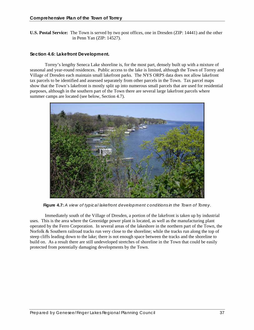
Section 4.6: Lakefront Development. Torrey’s lengthy Seneca Lake shoreline is, for the most part, densely built up with a mixture of seasonal and year-round residences. Public access to the lake is limited, although the Town of Torrey and Village of Dresden each maintain small lakefront parks. The NYS ORPS data does not allow lakefront tax parcels to be identified and assessed separately from other parcels in the Town. Tax parcel maps show that the Town’s lakefront is mostly split up into numerous small parcels that are used for residential purposes, although in the southern part of the Town there are several large lakefront parcels where summer camps are located (see below, Section 4.7).
Figure 4.7: A view of typical lakefront development conditions in the Town of Torrey. Immediately south of the Village of Dresden, a portion of the lakefront is taken up by industrial
uses. This is the area where the Greenidge power plant is located, as well as the manufacturing plant operated by the Ferro Corporation. In several areas of the lakeshore in the northern part of the Town, the Norfolk & Southern railroad tracks run very close to the shoreline; while the tracks run along the top of steep cliffs leading down to the lake; there is not enough space between the tracks and the shoreline to build on. As a result there are still undeveloped stretches of shoreline in the Town that could be easily protected from potentially damaging developments by the Town.

Comprehensive Plan of the Town of Torrey
Prepared by Genesee/Finger Lakes Regional Planning Council 38
Figure 4.8: A portion of undeveloped lakeshore in the Town. There is not enough space between
the railroad tracks and the shoreline in some parts of the Town to allow development along the lakefront. Areas such as this should be retained in their natural condition.
Section 4.7: Community Organizations and Recreation. The Town is host to three large summer camps and retreats, which are operated by religious organizations. Other organizations that play an important role in local recreation include the Seneca Lake Duck Hunter’s Club and The Friends of the Outlet, Inc. Camp Long Point and Retreat Center is operated by the Empire State Division of the Salvation Army and is located on 150 acres of land around Long Point, a tip of land extending out into Seneca Lake. This facility has been providing summer camping services to children from Upstate New York since 1953. In addition, this facility provides conference and retreat services. Camp Seneca Lake (CSL) is operated by the Jewish Community Center of Greater Rochester. It mainly serves elementary, middle, and high school age children from Jewish communities around Upstate New York, although other campers come in from around the country and Canada. The camp is located on 200 acres and has about 1500 feet of shoreline along the lake. Camp Whitman on Seneca Lake is a boys and girls Christian camp that is located on 117 acres. Like the other camps in town, it provides a wide range of outdoor recreational and athletic opportunities for its campers. This camp is operated by the Presbyteries of Geneva and the Genesee Valley. In addition to the organizations profiled above, a variety of other recreational opportunities are available in the Town. Common outdoor recreational activities in the Town include hiking, biking, swimming, skiing, and hunting. The Seneca Lake Duck Hunter’s Club is a major local social center and supports a variety of hunting activities. The Friends of the Outlet, Inc. is a non-profit group that is primarily involved in maintaining and expanding the Keuka Outlet Trail.