chapter 15 – setting layer symbology
TRANSCRIPT

David Tenenbaum – EEOS 472 – UMass Boston
Map symbology and ArcCatalog
Chapter 15 – Setting layer symbology– pp. 263-293– Exercises 15A, 15B & 15C
Chapter 16 – Using ArcCatalog Objects in ArcMap– pp. 295-314– Exercises 16A & 16B

David Tenenbaum – EEOS 472 – UMass Boston
Chapter 15 – Setting layer symbology
• Setting layer color• Setting layer symbols• Creating a class breaks renderer

David Tenenbaum – EEOS 472 – UMass Boston
Chapter 15 – Setting layer symbology
• Let’s take a moment to think about the data files that are used when we make a map using ArcGIS:– The spatial data itself is stored in a variety of possible formats
(shapefiles, coverages, in geodatabases, etc.), but these just contain information about location and attributes
– The project file stores information about what spatial data to include in the map and how to symbolize it
• You can think of a project file like a recipe, and the spatial data files it references as ingredients it uses– There is nothing specific about how to symbolize the data
stored in the spatial data files– There is no spatial data stored in the project file itself

David Tenenbaum – EEOS 472 – UMass Boston
Chapter 15 – Setting layer symbology
• This is a very efficient setup:– When we make a map, we don’t change the underlying spatial
data files– This means they can act as ‘ingredients’ for lots of maps
• The symbolization decisions sit within the project document
• As we know from our experience in this course up to this point, we can extensively customize the functionality in projects by changing the GUI elements and coding VBA
• Thus, we can use code to set the symbology of layers in our maps, which in many cases allows us to do things that would be difficult for the user to do manually (?)

David Tenenbaum – EEOS 472 – UMass Boston
Chapter 15 – Setting layer symbology
• When we point ArcGIS towards a spatial data file to add to a map, it gets added as a layer
• Through the GUI, we use legends to specify the symbology that controls how that layer is shown
• Using VBA code, we use objects from the renderer class to control the symbology (when a user does this in the GUI, they are really manipulating an underlying renderer)

David Tenenbaum – EEOS 472 – UMass Boston
Chapter 15 – Setting layer symbologyInterface inheritance
• Recall back in Chapter 10 when we learned of class inheritance: Derived classes can take over (or inherit) properties, methods, and interfaces of the pre-existing classes, which are referred to as base classes
• In this chapter, we look at a form of inheritance that is a subset of the above, called interface inheritance:– The properties and methods associated with a particular
interface are inherited, but properties and methods from other interfaces on the same class ARE NOT inherited here
ISimpleLineSymbolSimpleLineSymbolISimpleLineSymbol : ILineSymbol
Style: esriSimpleLineStyle
Name of the inherited interface

David Tenenbaum – EEOS 472 – UMass Boston
Setting layer color
• By default, when a layer is added to a map using the GUI, it is a symbolized with a single random color
• This is the default renderer assigned to the layer• As an alternative, we can write code to make use of
another renderer
FeatureLayer
Symbol
Color
*
Renderer– Every feature layer has a
renderer– Renderers are composed of
symbols– Every symbol has a color
(different kinds of symbols will have other sorts of characteristics as well)
David Tenenbaum – EEOS 472 – UMass Boston
Setting layer color
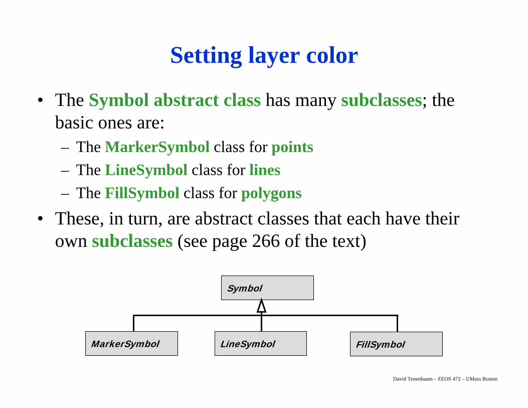
• The Symbol abstract class has many subclasses; the basic ones are:– The MarkerSymbol class for points– The LineSymbol class for lines– The FillSymbol class for polygons
• These, in turn, are abstract classes that each have their own subclasses (see page 266 of the text)
Symbol
MarkerSymbol LineSymbol FillSymbol

David Tenenbaum – EEOS 472 – UMass Boston
Setting layer color
• The usual approach applies here: Symbols and their Colors are declared with the Dim keyword, created with the New keyword, and properties are set with the object.property syntax
• Every FeatureLayer has one FeatureRenderer; FeatureRenderer is an abstract class with eight subclassesfor the various legend types:– UniqueValueRenderer– DotDensityRenderer– SimpleRenderer– ClassBreaksRenderer
– ScaleDependentRenderer– ChartRenderer– BitUniqueValueRenderer– ProportionalSymbolRenderer

David Tenenbaum – EEOS 472 – UMass Boston
Setting layer symbols
• In addition to specifying the characteristics of symbols yourself, you can also draw upon pre-existing sets of symbols
• ArcGIS symbols are stored in the Style Manager, grouped by style gallery classes that contain individual style gallery items
• These are designed to be used for common thematic maps of various types
• This is as simple as finding the styles you wish to use in the Manager, and then navigating the associated objects and classes (known as Enums, from enumerations) to obtain those symbols for your use

David Tenenbaum – EEOS 472 – UMass Boston
Creating a class breaks renderer
• A particularly useful application of manipulating legends / renderers by code is to create them with particular ranges of associated attribute values
• This kind of renderer is a ClassBreaksRenderer, and by working with these through VBA, you can specify the exact ranges of attribute values associated with particular symbols
• You might use this approach if you are making many similar maps, and want to ensure they all have precisely the same legend (and ranges of values associated with particular symbols)

David Tenenbaum – EEOS 472 – UMass Boston
Chapter 16 – Using ArcCatalog objects in ArcMap
• Adding layer files to ArcMap• Making your own Add Data dialog
box

David Tenenbaum – EEOS 472 – UMass Boston
Chapter 16 – Using ArcCatalog objects in ArcMap
• You are familiar enough with ArcGIS to know that its functionality is broken up into different applications:– Map-making happens in ArcMap– Management of data files happens in ArcCatalog
• Even if you’re going to develop VBA code primarily for ArcMap, you’ll need to work with some ArcCatalog classes and objects to manage data files (that you might to a map, for example)
• To be totally accurate, all ArcObjects are available in all ArcGIS applications, although some are associated with the object model diagrams of particular applications

David Tenenbaum – EEOS 472 – UMass Boston
Chapter 16 – Using ArcCatalog objects in ArcMap
• The ArcCatalog object model has similar starting pointsto that of ArcMap– There is an ArcCatalog Application object named Application– There is a GxDocument object named ThisDocument
• One key difference is the location where customizations can be stored– Unlike ArcMap with its options (the project .mxds, base
templates and the normal.mxt template), ArcCatalog has only one place where customizations are stored, its own normal.gxt template (this presents some problems in conveniently distributing ArcCatalog customizations)
• Just as many objects in ArcMap have the Mx prefix in their name, Gx is the common prefix for ArcCatalog

David Tenenbaum – EEOS 472 – UMass Boston
MxDocumentCoClass
Applicationclass
MapCoClass
IMapIActiveView
*
LayerAbstract
*
FeatureLayerCoClass
RasterLayerCoClass
GraphicsLayerCoClass …
ThisDocument
Normal template (normal.mxt)Base templateMap document
Chapter 16 – Using ArcCatalog objects in ArcMap
ArcMap ObjectModel Diagram

David Tenenbaum – EEOS 472 – UMass Boston
ApplicationClass
GxCatalogCoClass
GxObjectAbstract*
GxLayerCoClass
GxMapCoClass
GxTextfileCoClass
GxPrjFileCoClass
Normal template (normal.gxt)
GxFileClass
Chapter 16 – Using ArcCatalog objects in ArcMap
ThisDocument
ArcCatalog ObjectModel Diagram
GxDocumentClass

David Tenenbaum – EEOS 472 – UMass Boston
ApplicationClass
GxCatalogCoClass
GxObjectAbstract*
GxFileClass
Chapter 16 – Using ArcCatalog objects in ArcMap
• The ArcCatalog Application is composed of GxCatalog objects, which in turn are composed of GxObjects
• A GxObject is any file, folder, disk connection, or other object you can click on in the tree view shown in the left-hand pane of ArcCatalog
Several kinds of GxObjects, shown in the tree view
GxDocumentClass

David Tenenbaum – EEOS 472 – UMass Boston
GxDialogCoClass
ProjectedCoordinatesSystemDialog
CoClass
GeogaphicCoordinatesSystemDialog
CoClass
TableDefinitionDialogCoClass
SpatialReferenceDialog
CoClass
Chapter 16 – Using ArcCatalog objects in ArcMap
• There are five further coclasses in the ArcCatalog object model diagram that represent dialog boxes
• Each has its uses, but particularly important to us is the GxDialog, which gives us the capability to make customized dialog boxes for specifying files to be opened or saved

David Tenenbaum – EEOS 472 – UMass Boston
Adding layer files to ArcMap
• A layer file (extension .lyr) acts as an intermediate between a spatial data source and the Map document: It stores information about symbology, the path to the data set etc.– This simplifies adding a layer to a Map with a particular
symbolization; it is all set up alreadyGxObject
Abstract
GxLayerCoClass
GxFileCoClass
IGxFile
IGxLayer
Path
Layer
• A GxLayer is a GxFile, and both are GxObjects, and as they are coclasses, either can be created directly
• To create one from a file, use GxFile’s path property:

David Tenenbaum – EEOS 472 – UMass Boston
Adding layer files to ArcMap
• Set up the GxLayer object by declaring and creating it:Dim pGxLayer As IGxLayerSet pGxLayer = New GxLayer
• Now get the IGxFile interface to use the path property:Dim pGxFile as IGxFile
Set pGxFile = pGxLayerGxObject
Abstract
GxLayerCoClass
GxFileCoClass
IGxFile
IGxLayer
Path
Layer
• Now, with a known path to our layer file, set the path property:pGxFile.Path = “C:\the.lyr”
• The layer is now ready to use with our pMxDoc

David Tenenbaum – EEOS 472 – UMass Boston
Making your own Add Data dialog box
• In many cases, rather than having a known path to the data we want to add, instead we give the user the chance to navigate to the correct directory and select the data source using a dialog box
• The GxDialog is designed just for this purpose: It allows to create a file selection dialog box that we can customize in various ways (e.g. to allow specific file types to be selected, single or multiple files selected, what the title and buttons say, what directory it opens in etc.)

David Tenenbaum – EEOS 472 – UMass Boston
Making your own Add Data dialog box
• For example, to create a GxDialog titled “Add Data”, that starts in “Catalog”, with a Button that says “Add”, and only allows the selection of a single file:Dim pGxDialog As IGxDialogSet pGxDialog = New GxDialogpGxDialog.ButtonCaption = “Add”pGxDialog.StartingLocation = _“Catalog”pGxDialog.Title = “Add Data”
• We can further customize the GxDialog by restricting the type of files it can be used to open using an ObjectFilter

David Tenenbaum – EEOS 472 – UMass Boston
Making your own Add Data dialog box
• There are a wide variety of typesof GxObjectFilter to suit whatever you need your GxDialog to get
• For example to allow our GxDialog to just open layers:Dim pLFilter as IGxFilterLayersSet pLFilter = New GxFilterLayers
• We then set our GxDialog’sObjectFilter propertyaccordingly:Set pGxDialog.ObjectFilter = _pLFilter

David Tenenbaum – EEOS 472 – UMass Boston
Making your own Add Data dialog box
• We need to create one more object to use our GxDialog– An EnumGxObject gives access to the members that are
enumerated through the ArcCatalog tree view– Essentially, this gives us a way to get the files that the user
chooses through the dialogDim pLayerFiles As IEnumGxObject
• We can now open the GxDialog:pGxDialog.DoModalOpen 0, pLayerFiles
• We can now retrieve the filesfrom the Enum object by using its Next method

David Tenenbaum – EEOS 472 – UMass Boston
Making your own Add Data dialog box
• The result of the Next method will be a GxObject, so we need to declare it as such, and then we can set its value by getting the value from the EnumGxObject using the Next method:Dim pLayerFile As IGxObjectSet pLayerFile = pLayerFiles.Next
• Since we used AllowMultiSelect = False, we know our EnumGxObject is going to contain just a single value
• Otherwise, we could loop, and apply the Next method repeatedly to get multiple values

David Tenenbaum – EEOS 472 – UMass Boston
Next Topic:
Displaying and selecting features