chapter 13, ecosystem resources
TRANSCRIPT
June 2021 Utah Department of Transportation 13-1
Chapter 13: Ecosystem Resources
13.1 Introduction This chapter describes the ecosystem resources, habitat types, and wildlife species in the ecosystem resources impact analysis area and how these resources would be directly and indirectly affected by the project alternatives.
Ecosystem Resources Impact Analysis Area. The ecosystem resources impact analysis area extends along State Route (S.R.) 210 from its intersection with S.R. 190/Fort Union Boulevard in Cottonwood Heights to its terminus in the town of Alta, including the Alta Bypass Road (for a graphic depiction of the impact analysis area, see Figure 13.3-1, Wildlife Habitat Types in the Ecosystem Resources Impact Analysis Area, on page 13-7). It also includes the area around the gravel pit adjacent to Wasatch Boulevard north of Fort Union Boulevard and the existing park-and-ride lot at 9400 South and Highland Drive. For wildlife habitat, the impact analysis area includes the entirety of Little Cottonwood Canyon.
The areas adjacent to Wasatch Boulevard, the gravel pit, and the park-and-ride lot are primarily residential and commercial developments. From North Little Cottonwood Road through the town of Alta, the impact analysis area includes the wildlife, vegetation, and aquatic resources present in addition to a mix of residential and commercial (ski resort) development.
13.2 Regulatory Setting For a discussion of the Utah Division of Water Rights stream alteration permit program for streams that would be affected by the action alternatives, see Chapter 24, Permits, Reviews, Clearances, and Approvals. For a discussion of Executive Order 11988, Floodplain Management, see Chapter 14, Floodplains.
13.2.1 Threatened and Endangered Species The Endangered Species Act (16 United States Code [USC] Sections 1531–1544) provides for the conservation of threatened and endangered species and the ecosystems on which they depend. Section 9 of the Endangered Species Act prohibits the “taking” of any endangered species without a permit, and Section 3 of the Act defines “taking” broadly to include actions that are not necessarily intended to cause harm to the species (an “incidental taking”).
What is the ecosystem resources impact analysis area?
The ecosystem resources impact analysis area extends along S.R. 210 from its intersection with S.R. 190/Fort Union Boule-vard in Cottonwood Heights to its terminus in the town of Alta, including the Alta Bypass Road. It also includes the area around the gravel pit and the existing park-and-ride lot at 9400 South and Highland Drive. For wildlife habitat, the impact analysis area includes the entirety of Little Cottonwood Canyon.
What is a take of a listed species?
The term take means to harass, harm, pursue, hunt, shoot, wound, kill, trap, capture, or collect an individual of a species listed as threatened or endan-gered (16 USC Section 1532).

June 2021 13-2 Utah Department of Transportation
Section 7 of the Endangered Species Act requires federal agencies to consult with the U.S. Fish and Wildlife Service (USFWS) before taking any action that could affect a federally listed threatened or endangered species or designated critical habitat for an endangered species. In addition, federal agencies must ensure that their actions are not likely to jeopardize the continued existence of any listed species or to destroy or adversely modify any designated critical habitat.
Under the Memorandum of Understanding described in Section 1.1, Introduction, in Chapter 1, Purpose and Need, the Utah Department of Transportation (UDOT) has been assigned the Federal Highway Administration’s (FHWA) responsibilities for compliance with Section 7 requirements as part of the environmental review process for highway projects in Utah.
If UDOT (acting in the role of FHWA) makes a determination that a proposed action would have “no effect” on a threatened or endangered species, no further consultation is required; this determination does not require concurrence from USFWS. In working with the U.S. Department of Agriculture (USDA) Forest Service, UDOT has determined through the analysis in this Environmental Impact Statement (EIS) that there would be “no effect” on any threatened or endangered species from the project alternatives; therefore, the Endangered Species Act is not pertinent to the S.R. 210 Project (UDOT 2021).
13.2.2 Migratory Bird Treaty Act The Migratory Bird Treaty Act makes it unlawful to take, import, export, possess, sell, purchase, or barter any migratory bird, with the exception of the taking of game birds during established hunting seasons. The law also applies to feathers, eggs, nests, and products made from migratory birds. This law is of particular concern when birds nest on bridges, buildings, signs, lighting structures, or ferry dock structures. Executive Order 13186, Responsibilities of Federal Agencies to Protect Migratory Birds (signed by President Bill Clinton on January 10, 2001), directs federal agencies taking actions likely to affect migratory birds to support the Migratory Bird Treaty Act, including requiring agencies to evaluate the effects on migratory birds and species of concern in National Environmental Policy Act (NEPA) studies.
13.2.3 Bald and Golden Eagle Protection Act The Bald and Golden Eagle Protection Act makes it unlawful to take, import, export, sell, purchase, transport, or barter any bald or golden eagle or their parts, products, nests, or eggs. Take includes pursuing, shooting, poisoning, wounding, killing, capturing, trapping, collecting, molesting, or disturbing eagles.
What is critical habitat?
Critical habitat is defined as geographic locations critical to the existence of a threatened or endangered species.

June 2021 Utah Department of Transportation 13-3
13.2.4 Clean Water Act The U.S. Army Corps of Engineers (USACE) developed a definition of waters of the United States in the 1972 Clean Water Act (33 USC Section 1251). Waters of the United States are jurisdictional waters and are defined in 40 Code of Federal Regulations (CFR) Section 120.2 as (i) the territorial seas, and waters which are currently used, or were used in the past, or may be susceptible to use in interstate or foreign commerce, including waters which are subject to the ebb and flow of the tide; (ii) tributaries; (iii) lakes and ponds, and impoundments of jurisdictional waters; and (iv) adjacent wetlands. Under Section 404(b)(1) of the Clean Water Act, wetlands are considered special aquatic sites, and when they meet definition of adjacent wetland in 40 CFR Section 120.2 they are considered waters of the United States.
As described in 40 CFR Section 230.1, the objective of the Clean Water Act is to maintain and restore the chemical, physical, and biological integrity of the waters of the United States. Pursuant to the Clean Water Act, USACE has jurisdiction over all waters of the United States. Section 404 of the Clean Water Act prohibits the discharge of dredged or fill material into wetlands or other “waters of the United States” without a permit. Any person, firm, or agency planning to alter or work in waters of the United States, including the discharge of dredged or fill material, must first obtain authorization from USACE under Clean Water Act Section 404 and, if applicable, Section 10 of the Rivers and Harbors Act of 1899 (33 USC Section 403) for work within navigable waters of the United States. Additionally, Executive Order 11990, Protection of Wetlands, directs federal agencies to take actions to minimize the destruction, loss, or degradation of wetlands and to preserve and enhance the natural and beneficial values of wetlands in carrying out agency responsibilities.
USACE issues Section 404 permits pursuant to the Section 404(b)(1) Guidelines, which were issued by the U.S. Environmental Protection Agency (40 CFR Part 230). One of the key requirements in the guidelines is that a Section 404 permit cannot be issued for an alternative if there is another practicable alternative that would cause less adverse impact to aquatic resources. This requirement is commonly known as the requirement to select the “least environmentally damaging practicable alternative.” In addition, Executive Order 11990 also states that agencies are directed to avoid new construction in wetlands unless an agency determines that there are no practicable alternatives to such construction.
What are aquatic resources?
Aquatic resources include rivers, lakes, streams, creeks, natural ponds, and wetlands.
June 2021 13-4 Utah Department of Transportation
13.1.1 Riparian Habitat Conservation Areas Defined in the Revised Forest Plan: Wasatch-Cache National Forest
The Revised Forest Plan: Wasatch-Cache National Forest (USDA Forest Service 2003) includes guidelines for Riparian Habitat Conservation Areas (RHCAs). RHCAs include traditional riparian corridors, wetlands, intermittent streams, and other areas that help maintain the integrity of aquatic ecosystems by (1) influencing the delivery of coarse sediment, organic matter, and woody debris to streams; (2) providing root strength for channel stability; (3) shading the stream; and (4) protecting water quality. This designation still allows for a full range of activities, but it emphasis the achievement of riparian management objectives that are identified on a site-by-site basis. These objectives should include riparian vegetation and in-stream habitat condition. The RHCAs, by condition, are defined below.
Category 1, Fish-bearing streams: RHCAs consist of the stream and the area on either side of the stream extending from the edges of the active stream channel to 300 feet slope distance (600 feet, including both sides of the stream channel).
Category 2, Permanently flowing, non-fish-bearing streams: RHCAs consist of the stream and the area on either side of the stream extending from the edges of the active stream channel to 150 feet slope distance (300 feet, including both sides of the stream channel).
Category 3, Ponds, lakes, reservoirs, and wetlands greater than 1 acre: RHCAs consist of the body of water or wetland and the area to 150 feet slope distance from the edge of the maximum pool elevation of constructed ponds and reservoirs or from the edge of the wetland, pond, or lake.
Category 4, Seasonally flowing or intermittent streams, wetlands less than 1 acre, landslides, and landslide-prone areas: This category includes features with high variability in size and site-specific characteristics. At a minimum, the interim RHCAs must include landslides and landslide-prone areas, 100 feet slope distance in watersheds containing Bonneville or Colorado River cutthroat trout, and 50 feet slope distance for watersheds not containing Bonneville or Colorado River cutthroat trout.

June 2021 Utah Department of Transportation 13-5
13.3 Affected Environment
13.3.1 Methodology UDOT used several methods to collect data regarding the elements of the ecosystem that could be affected by the action alternatives. These methods included conducting literature reviews, consulting with resource agency personnel, including from the USDA Forest Service; performing field surveys; and interpreting aerial photographs and maps.
UDOT consulted the Environmental Conservation Online System (USFWS 2020a), the NatureServe Explorer (NatureServe, no date), and the Utah Conservation Data Center (Utah Division of Wildlife Resources, no date) for lists of federally threatened, endangered, or candidate species known to be present in Salt Lake County, Utah, and to determine whether there were existing records of occurrence for these species in the ecosystem resources impact analysis area. In addition, UDOT consulted the Utah Natural Heritage Program (UNHP) for lists of either federally listed or state-listed sensitive species known to be present in the impact analysis area. The official letters from USFWS and UNHP are provided in Appendix 13A, Pertinent Correspondence.
UDOT conducted field surveys for wildlife; vegetation; rare, threatened, and endangered species; and aquatic resources during June and July 2018 and July 2019. The surveys focused on the area along S.R. 210 that is most likely to be directly impacted by the action alternatives. The surveys were conducted in the areas accessible by foot within 125 feet on either side of S.R. 210, in addition to some wider portions encompassing specific proposed alternatives. This area that was surveyed is referred to as the field survey area.
UDOT identified, mapped, and delineated wetlands and other aquatic resources in the field survey area using the Corps of Engineers Wetlands Delineation Manual (USACE 1987), the Regional Supplement to the Corps of Engineers Wetland Delineation Manual: Western Mountains, Valleys and Coast (Version 2.0) (USACE 2010), and A Guide to Ordinary High Water Mark (OHWM) Delineation for Non-perennial Streams in the Western Mountains, Valleys, and Coast Region of the United States (Mersel and Lichvar 2014). Aquatic resource boundaries were mapped through a combination of global positioning system (GPS)-based field mapping (using ArcGIS Collector software and an iPad) and desktop digitization referencing aerial images. These data were also used to calculate the area, lengths, and widths of aquatic resources in the field survey area (UDOT 2019).
UDOT identified RHCAs that have the potential to be impacted by the action alternatives. Potential RHCAs were identified using a GIS stream layer from the wetland delineation data to create buffers around aquatic resources depending on aquatic resource categorization. A 300-foot buffer was created on either side of Little Cottonwood Creek, and 100-foot buffers were created around seasonally flowing tributaries to Little Cottonwood Creek. In the GIS software, the alternative alignments were overlaid onto the RHCA buffers to determine where impacts from the action alternatives might occur.
What is NatureServe?
NatureServe is a nonprofit organization that provides proprietary wildlife conservation-related data, tools, and services to private and government clients, partner organizations, and the public.
What is the field survey area?
The field survey area is the area generally within 100 feet on either side of S.R. 210 that was surveyed during June and July 2018 and July 2019.
June 2021 13-6 Utah Department of Transportation
To address the potential for indirect impacts outside the field survey area and within the impact analysis area, UDOT collected data from the USDA Forest Service, other resource agencies, and existing resource documents referencing Little Cottonwood Canyon. The Gap Analysis Program (GAP)/LANDFIRE National Terrestrial Ecosystems data set (USGS 2016) was used to create a general, canyon-wide habitat map. This data set includes detailed vegetation and land cover patterns for the continental United States. The data set incorporates the Ecological System classification system developed by NatureServe.
13.3.2 General Overview of the Ecosystem Resources Impact Analysis Area
The Wasatch Mountains are part of the Basin and Range Province. Little Cottonwood Canyon was carved by glacial activity, resulting in the distinct “U” shape of the canyon. The ecosystem resources impact analysis area is considered part of the Wasatch and Uinta Mountains Ecoregion, with the higher elevations being part of the distinct Wasatch Mountain Zone and the lower elevations considered Semiarid Foothills. The elevation of the impact analysis area ranges from over 11,000 feet at the peaks adjacent to the canyon to 5,000 feet along Wasatch Boulevard.
Little Cottonwood Canyon is part of the USDA Forest Service’s Central Wasatch Management Area (USDA Forest Service 2003) and is a valuable watershed for Salt Lake City and the surrounding cities along the Wasatch Front. One of the primary needs for this management area is to provide long-term culinary water to the growing population of the Salt Lake Valley while balancing this need with recreation opportunities for both local and international users. Close to 81% of the land in the canyon is considered National Forest System land, specifically the Uinta-Wasatch-Cache National Forest.
13.3.2.1 Vegetation
13.3.2.1.1 General Plant Species
UDOT categorized the ecosystem resources impact analysis area into five broad wildlife habitat types: forest/woodland, shrubland, meadow/grassland, bedrock, and open water. These habitat types, which are based on the GAP/LANDFIRE National Terrestrial Ecosystems data set, make up about 16,926 acres of the 17,802-acre impact analysis area. The remaining 876 acres are developed spaces, which includes existing roads, an aggregate (gravel) mine, business facilities, and residential areas.
Table 13.3-1 lists, and Figure 13.3-1 below shows, the distribution of these habitat types throughout the impact analysis area. A list of plant species observed in the area is included in the aquatic resources delineation report (UDOT 2019) for the S.R. 210 Project. The five habitat types are described in more detail after the figure.
Table 13.3-1. Wildlife Habitat Acreage in the Ecosystem Resources Impact Analysis Area
Habitat Type Acres
Percentage of Existing Habitat
Developed 876.1 5%
Forest/woodland 6,620.5 37%
Shrubland 2,412.0 13%
Meadow/grassland 1,173.7 7%
Bedrock 6,688.6 37%
Open water 31.0 1%
Total 17,801.9 100%

June 2021 Utah Department of Transportation 13-7
Figure 13.3-1. Wildlife Habitat Types in the Ecosystem Resources Impact Analysis Area

June 2021 13-8 Utah Department of Transportation
Forest/woodland Habitat
Forest/woodland habitat totals about 6,620.5 acres and consists of the following GAP land cover types:
Rocky Mountain Aspen Forest and Woodland
Rocky Mountain Bigtooth Maple Ravine Woodland
Rocky Mountain Subalpine-Montane Limber-Bristlecone Pine Woodland
Rocky Mountain Subalpine Dry-Mesic Spruce-Fir Forest and Woodland
Rocky Mountain Subalpine Mesic Spruce-Fir Forest and Woodland
Rocky Mountain Lodgepole Pine Forest-Rocky Mountain Montane Dry-Mesic Mixed Conifer Forest and Woodland
Rocky Mountain Montane Mesic Mixed Conifer Forest and Woodland
Colorado Plateau Pinyon-Juniper Woodland
Inter-Mountain Basins Mountain Mahogany Woodland and Shrubland
Rocky Mountain Lower Montane Riparian Woodland and Shrubland
Large areas in the top half of Little Cottonwood Canyon are dominated by quaking aspen (Populus tremuloides) forest with an understory of shrubs and/or an herbaceous layer. Some conifer species commonly found with the aspen include subalpine fir (Abies lasiocarpa), Engelmann spruce (Picea engelmannii), and Douglas fir (Pseudotsuga menziesii). Associated shrub species include Saskatoon serviceberry (Amelanchier alnifolia), big sagebrush (Artemisia tridentata), kinnikinnick (Arctostaphylos uva-ursi), western mountain ash (Sorbus scopulina), common juniper (Juniperus communis), gooseberry currant (Ribes montigenum), Wood’s rose (Rosa woodsii), thimbleberry (Rubus parviflorus), mountain snowberry (Symphoricarpos oreophilus), and creeping barberry (Mahonia repens).
Coniferous forest and woodland is also spread throughout the canyon at higher elevations and on north-facing slopes. Coniferous species include Douglas fir, subalpine fir, white fir (Abies concolor), and Engelmann spruce. Quaking aspen is often present as well as kinnikinnick, creeping barberry, Oregon boxleaf (Paxistima myrsinites), mountain snowberry, and thimbleberry. Some cooler ravines throughout the canyon are dominated by Rocky Mountain maple (Acer glabrum) and bigtooth maple (Acer grandidentatum) and also include Gambel oak (Quercus gambelii), conifers, and box elder (Acer negundo).
Riparian habitat occurs primarily adjacent to Little Cottonwood Creek as well as smaller streams and wetland areas. Riparian tree and shrub species include box elder, water birch (Betula occidentalis), narrowleaf cottonwood (Populus angustifolia), willow (Salix) species, and redosier dogwood (Cornus sericea).
Little Cottonwood Creek was identified as an RHCA and is classified as a Class 1 riparian area (USDA Forest Service 2003). The Class 1 rating is defined as the following:
Riparian areas with a high rating should be given special management considerations to protect or enhance the high resource value(s) of the area. This might include exclusion or intensive management of activities such as livestock grazing, concentrated recreation, road construction, dam construction, etc., as appropriate, to maintain or enhance the area for the identified resource values. Any stream with riparian-dependent threatened, endangered, or sensitive species is classified as a Class 1 riparian area.
June 2021 Utah Department of Transportation 13-9
Shrubland Habitat
Shrubland habitat totals about 2,412.0 acres and includes the following GAP land cover types:
Rocky Mountain Gambel Oak-Mixed Montane Shrubland Inter-Mountain Basins Big Sagebrush Steppe Inter-Mountain Basins Big Sagebrush Shrubland Inter-Mountain Basins Montane Sagebrush Steppe Rocky Mountain Subalpine-Montane Riparian Shrubland
Much of the north slope of the bottom half of Little Cottonwood Canyon is dominated by shrublands. Gambel oak woodlands are dominated by Gambel oak and can include Saskatoon serviceberry, big sagebrush, alderleaf mountain mahogany (Cercocarpus montanus), chokecherry (Prunus virginiana), rubber rabbitbrush (Ericameria nauseosa), and mountain snowberry. Gambel oak shrublands are common along dry foothills and lower mountain slopes, and they cover much of the south aspect on the bottom half of the canyon. Mountain mahogany woodlands and sagebrush steppe shrublands are intermixed in the Gambel oak shrublands.
Meadow/grassland Habitat
Meadow/grassland habitat totals 1,173.7 acres and consists of the following GAP land cover types:
Rocky Mountain Subalpine Mesic Meadow Southern Rocky Mountain Montane-Subalpine Grassland Rocky Mountain Alpine-Montane Wet Meadow Invasive Perennial Grassland Playa
The meadow/grassland habitat is often found intermixed with forests, woodlands, and shrublands as well as along ponds, lakes, and streams. Some of the canyon’s healthiest and most beautiful wildflower communities are in the meadows of Albion Basin (USDA Forest Service, no date). Some of the more conspicuous wildflower species include mountain bluebells (Mertensia ciliate), columbine (Aquilegia) species, western larkspur (Delphinium occidentale), blue flax (Linum perenne), sticky geranium (Geranium viscosissimum), silvery lupine (Lupinus argenteus), scarlet gilia (Ipomopsis aggregate), paintbrush (Castilleja) species, penstemon (Penstemon) species, and yarrow (Achillea millefolium). Various grasses and graminoid species can be found throughout the meadows and grasslands. Albion Basin is one of the most heavily visited sites during the summer and is the site of an annual wildflower festival.
Bedrock Habitat
Bedrock habitat totals 6,688.6 acres and consists of the following GAP land cover types:
Rocky Mountain Alpine Bedrock and Scree Rocky Mountain Cliff and Canyon
The bedrock habitat is visually conspicuous and occurs at the higher elevations throughout the canyon. Composed of steep cliff faces and rock outcrops, it is largely barren, but some areas are sparsely vegetated with conifers as well as scattered shrubs, forbs, and grasses.
June 2021 13-10 Utah Department of Transportation
Open Water Habitat
Open water habitat totals 31.0 acres and consists of high alpine lakes located on the south side of Little Cottonwood Canyon. These lakes are Cecret Lake, Lower and Upper Red Pine Lakes, and White Pine Lake. All of these lakes have a high visitation during the summer. Cecret Lake, located in Albion Basin, is easily accessible and has a large number of visitors, especially during wildflower season. Red Pine and White Pine Lakes are accessible via the White Pine Trailhead below the Snowbird resort.
13.3.2.1.2 Special-status Plant Species
Threatened, Endangered, and Candidate Species. UDOT’s database research and consultation with agencies indicates that no federally listed plant species are known to occur in Salt Lake County.
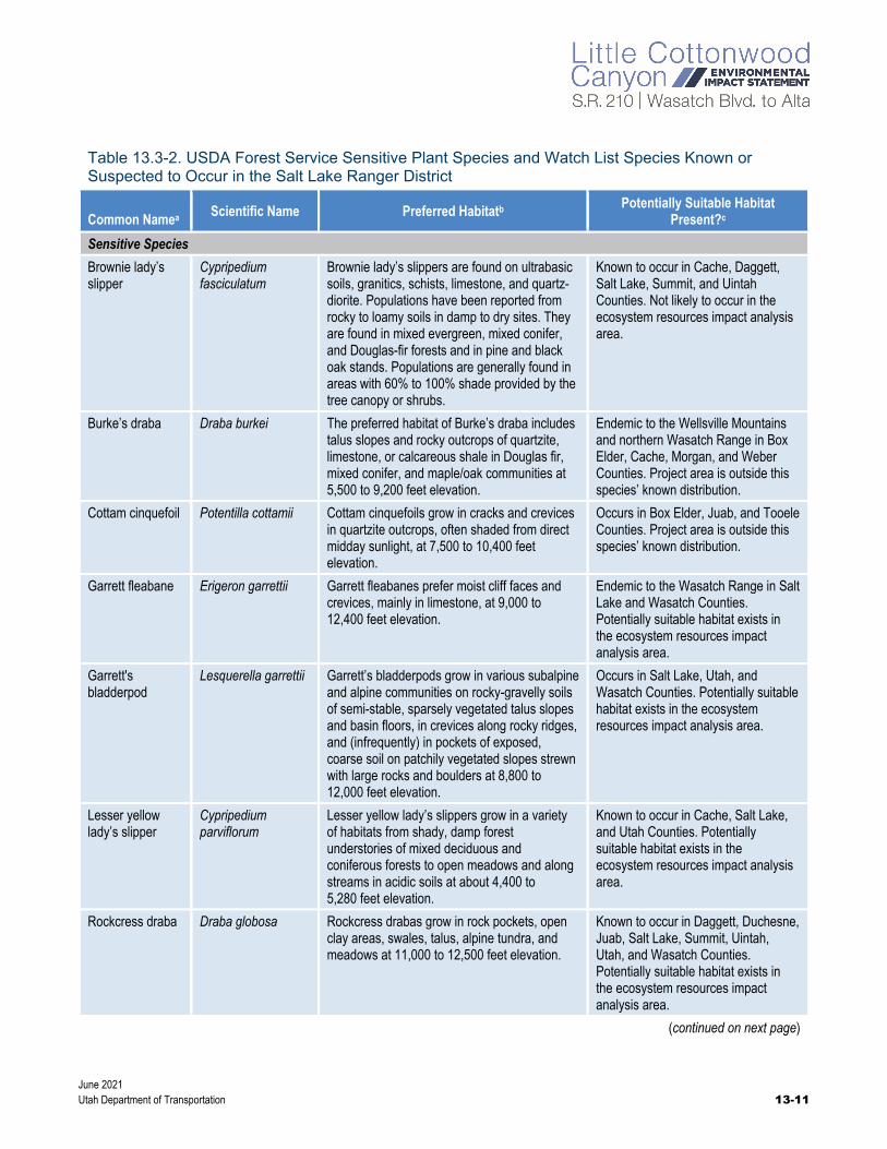
USDA Forest Service Sensitive Species. Representatives from the Uinta-Wasatch-Cache National Forest provided a list of 16 Forest Service sensitive species that are known or suspected to occur in the Salt Lake Ranger District. These sensitive species are listed in Table 13.3-2 along with information about potentially suitable habitat or documented occurrences in the ecosystem resources impact analysis area. The table also includes 4 additional species from the District’s watch list. (A watch list is a list of species that are not currently on a sensitive species list but might be added in the future depending on new information concerning threats to the species, the species’ biology, or statewide trends.)
General field surveys did not identify any of the species listed in Table 13.3-2. However, the USDA Forest Service stated that there are documented occurrences of some species in Little Cottonwood Canyon. Therefore, additional site-specific field surveys during the appropriate season will be conducted in 2021, and the results of the surveys will be included in the Final EIS.
What is potentially suitable habitat?
Potentially suitable habitat has been identified through research and consultation but has not been field-verified as being suitable.
June 2021 Utah Department of Transportation 13-11
Table 13.3-2. USDA Forest Service Sensitive Plant Species and Watch List Species Known or Suspected to Occur in the Salt Lake Ranger District
Common Namea Scientific Name Preferred Habitatb Potentially Suitable Habitat
Present?c
Sensitive Species
Brownie lady’s slipper
Cypripedium fasciculatum
Brownie lady’s slippers are found on ultrabasic soils, granitics, schists, limestone, and quartz-diorite. Populations have been reported from rocky to loamy soils in damp to dry sites. They are found in mixed evergreen, mixed conifer, and Douglas-fir forests and in pine and black oak stands. Populations are generally found in areas with 60% to 100% shade provided by the tree canopy or shrubs.
Known to occur in Cache, Daggett, Salt Lake, Summit, and Uintah Counties. Not likely to occur in the ecosystem resources impact analysis area.
Burke’s draba Draba burkei The preferred habitat of Burke’s draba includes talus slopes and rocky outcrops of quartzite, limestone, or calcareous shale in Douglas fir, mixed conifer, and maple/oak communities at 5,500 to 9,200 feet elevation.
Endemic to the Wellsville Mountains and northern Wasatch Range in Box Elder, Cache, Morgan, and Weber Counties. Project area is outside this species’ known distribution.
Cottam cinquefoil Potentilla cottamii Cottam cinquefoils grow in cracks and crevices in quartzite outcrops, often shaded from direct midday sunlight, at 7,500 to 10,400 feet elevation.
Occurs in Box Elder, Juab, and Tooele Counties. Project area is outside this species’ known distribution.
Garrett fleabane Erigeron garrettii Garrett fleabanes prefer moist cliff faces and crevices, mainly in limestone, at 9,000 to 12,400 feet elevation.
Endemic to the Wasatch Range in Salt Lake and Wasatch Counties. Potentially suitable habitat exists in the ecosystem resources impact analysis area.
Garrett's bladderpod
Lesquerella garrettii Garrett’s bladderpods grow in various subalpine and alpine communities on rocky-gravelly soils of semi-stable, sparsely vegetated talus slopes and basin floors, in crevices along rocky ridges, and (infrequently) in pockets of exposed, coarse soil on patchily vegetated slopes strewn with large rocks and boulders at 8,800 to 12,000 feet elevation.
Occurs in Salt Lake, Utah, and Wasatch Counties. Potentially suitable habitat exists in the ecosystem resources impact analysis area.
Lesser yellow lady’s slipper
Cypripedium parviflorum
Lesser yellow lady’s slippers grow in a variety of habitats from shady, damp forest understories of mixed deciduous and coniferous forests to open meadows and along streams in acidic soils at about 4,400 to 5,280 feet elevation.
Known to occur in Cache, Salt Lake, and Utah Counties. Potentially suitable habitat exists in the ecosystem resources impact analysis area.
Rockcress draba Draba globosa Rockcress drabas grow in rock pockets, open clay areas, swales, talus, alpine tundra, and meadows at 11,000 to 12,500 feet elevation.
Known to occur in Daggett, Duchesne, Juab, Salt Lake, Summit, Uintah, Utah, and Wasatch Counties. Potentially suitable habitat exists in the ecosystem resources impact analysis area.
(continued on next page)

June 2021 13-12 Utah Department of Transportation
Table 13.3-2. USDA Forest Service Sensitive Plant Species and Watch List Species Known or Suspected to Occur in the Salt Lake Ranger District
Common Namea Scientific Name Preferred Habitatb Potentially Suitable Habitat
Present?c
Slender moonwort
Botrychium lineare The preferred habitat of slender moonwort is highly variable. Western populations tend to occur at high elevations (about 4,900 to 9,800 feet) in meadows or roadsides with limestone-influenced substrates.
Known only from two historic collections in Utah in Duchesne and Salt Lake Counties. Potentially suitable habitat exists in the ecosystem resources impact analysis area.
Utah ivesiad Ivesia utahensis Utah ivesias grow on arid, steep, highly eroded and eroding slopes, often in quartzite talus, at 10,500 to 11,800 feet elevation.
Endemic to the central Wasatch Range, including Little Cottonwood Canyon. Documented occurrence in the ecosystem resources impact analysis area.
Wasatch drabad Draba brachystylis The preferred habit of Wasatch draba includes moist locations on rocky slopes in aspen and white fir/Douglas fir communities at 5,500 to 9,850 feet elevation.
Found in Cache, Duchesne, Juab, Salt Lake, and Utah Counties. Documented occurrence in the ecosystem resources impact analysis area.
Wasatch fitweedd Corydalis caseana spp. brachycarpa
Wasatch fitweeds grow in or along streams, including gravel bars, at 6,200 to 10,000 feet elevation.
Endemic to Salt Lake, Summit, Utah, Wasatch, and Weber Counties. Documented occurrence in the ecosystem resources impact analysis area.
Wasatch jamesiad Jamesia americana var. macrocalyx
Wasatch jamesias grow in mountain brush and spruce-fir communities, in cracks and crevices of rocky slopes, and often in granite or limestone cliffs at 6,600 to 9,900 feet elevation in the Wasatch Mountains.
Endemic to the Wasatch Mountains in Salt Lake, Utah, and Wasatch Counties as well as the Deep Creek Mountains in Juab and Tooele Counties. Documented occurrence in the ecosystem resources impact analysis area.
Wasatch pepperwortd
Lepidium montanum var. alpinum
Wasatch pepperworts are typically found in damp, rocky crevices at high elevations in mountain brush and spruce-fir communities.
Endemic to the Wasatch Mountains in Salt Lake, Utah, and Wasatch Counties as well as Paiute County. Documented occurrence in the ecosystem resources impact analysis area.
Wasatch shooting star
Dodecatheon dentatum ssp. utahense
Wasatch shooting stars prefer shady, moist, mossy places in cracks and crevices of limestone and quartz outcrops on thinly layered soils where water is seeping or flowing, and often in the spray of waterfalls, from 6,600 to 9,500 feet elevation.
Restricted to the Wasatch Range in Salt Lake County. Potentially suitable habitat exists in the ecosystem resources impact analysis area.
(continued on next page)
June 2021 Utah Department of Transportation 13-13
Table 13.3-2. USDA Forest Service Sensitive Plant Species and Watch List Species Known or Suspected to Occur in the Salt Lake Ranger District
Common Namea Scientific Name Preferred Habitatb Potentially Suitable Habitat
Present?c
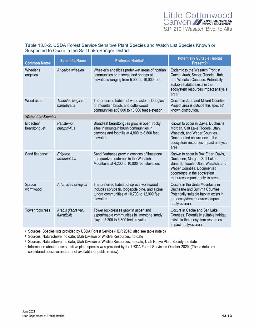
Wheeler’s angelica
Angelica wheeleri Wheeler’s angelicas prefer wet areas of riparian communities or in seeps and springs at elevations ranging from 5,000 to 10,000 feet.
Endemic to the Wasatch Front in Cache, Juab, Sevier, Tooele, Utah, and Wasatch Counties. Potentially suitable habitat exists in the ecosystem resources impact analysis area.
Wood aster Tonestus kingii var. barnebyana
The preferred habitat of wood aster is Douglas fir, mountain brush, and cottonwood communities at 6,000 to 10,000 feet elevation.
Occurs in Juab and Millard Counties. Project area is outside this species’ known distribution.
Watch List Species
Broadleaf beardtongued
Penstemon platyphyllus
Broadleaf beardtongues grow in open, rocky sites in mountain brush communities in canyons and foothills at 4,800 to 8,800 feet elevation.
Known to occur in Davis, Duchesne, Morgan, Salt Lake, Tooele, Utah, Wasatch, and Weber Counties. Documented occurrence in the ecosystem resources impact analysis area.
Sand fleabaned Erigeron arenarioides
Sand fleabanes grow in crevices of limestone and quartzite outcrops in the Wasatch Mountains at 4,200 to 10,000 feet elevation.
Known to occur in Box Elder, Davis, Duchesne, Morgan, Salt Lake, Summit, Tooele, Utah, Wasatch, and Weber Counties. Documented occurrence in the ecosystem resources impact analysis area.
Spruce wormwood
Artemisia norvegica The preferred habitat of spruce wormwood includes spruce fir, lodgepole pine, and alpine tundra communities at 10,700 to 12,000 feet elevation.
Occurs in the Uinta Mountains in Duchesne and Summit Counties. Potentially suitable habitat exists in the ecosystem resources impact analysis area.
Tower rockcress Arabis glabra var. furcatipilis
Tower rockcresses grow in aspen and aspen/maple communities in limestone sandy clay at 5,200 to 6,300 feet elevation.
Occurs in Cache and Salt Lake Counties. Potentially suitable habitat exists in the ecosystem resources impact analysis area.
a Sources: Species lists provided by USDA Forest Service (HDR 2018; also see table note d) b Sources: NatureServe, no date; Utah Division of Wildlife Resources, no date c Sources: NatureServe, no date; Utah Division of Wildlife Resources, no date; Utah Native Plant Society, no date d Information about these sensitive plant species was provided by the USDA Forest Service in October 2020. (These data are
considered sensitive and are not available for public review).
June 2021 13-14 Utah Department of Transportation
13.3.2.2 Terrestrial and Aquatic Wildlife
13.3.2.2.1 General Wildlife Species
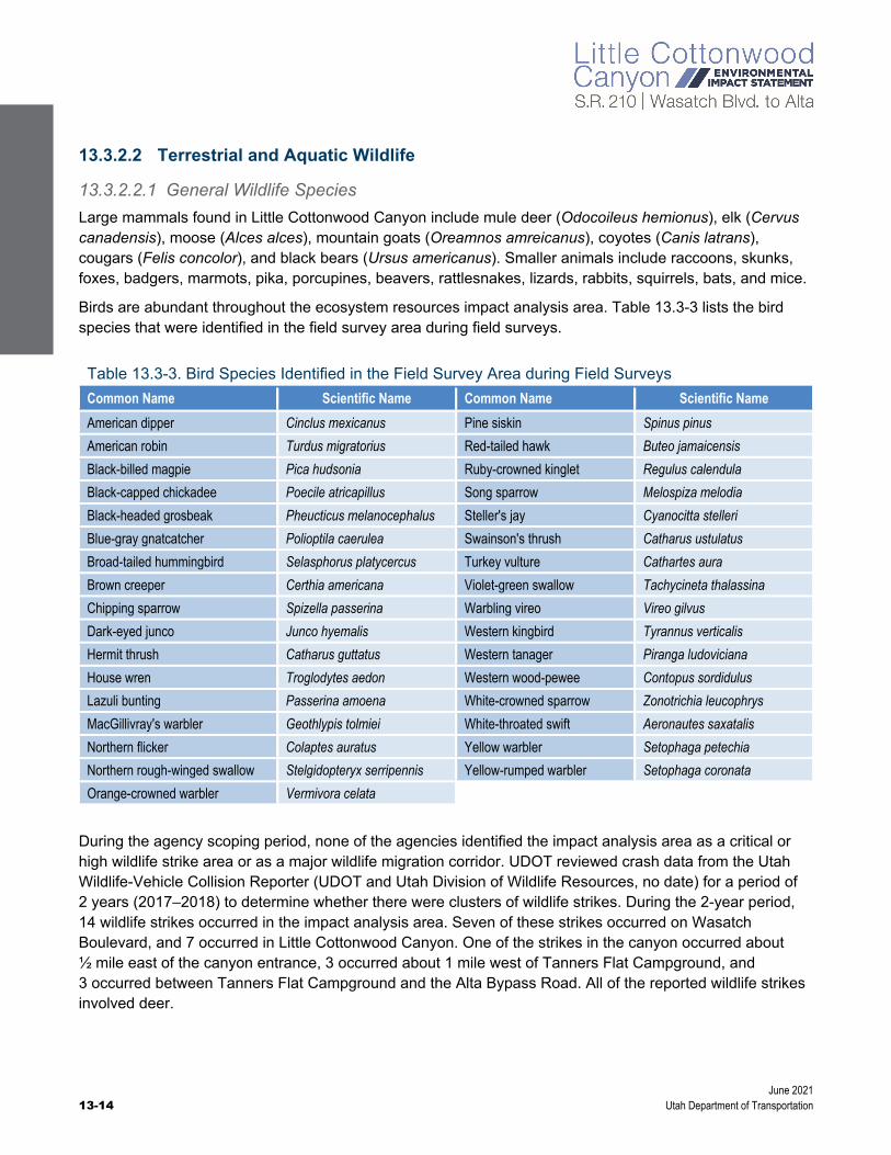
Large mammals found in Little Cottonwood Canyon include mule deer (Odocoileus hemionus), elk (Cervus canadensis), moose (Alces alces), mountain goats (Oreamnos amreicanus), coyotes (Canis latrans), cougars (Felis concolor), and black bears (Ursus americanus). Smaller animals include raccoons, skunks, foxes, badgers, marmots, pika, porcupines, beavers, rattlesnakes, lizards, rabbits, squirrels, bats, and mice.
Birds are abundant throughout the ecosystem resources impact analysis area. Table 13.3-3 lists the bird species that were identified in the field survey area during field surveys.
Table 13.3-3. Bird Species Identified in the Field Survey Area during Field Surveys
Common Name Scientific Name Common Name Scientific Name
American dipper Cinclus mexicanus Pine siskin Spinus pinus
American robin Turdus migratorius Red-tailed hawk Buteo jamaicensis
Black-billed magpie Pica hudsonia Ruby-crowned kinglet Regulus calendula
Black-capped chickadee Poecile atricapillus Song sparrow Melospiza melodia
Black-headed grosbeak Pheucticus melanocephalus Steller's jay Cyanocitta stelleri
Blue-gray gnatcatcher Polioptila caerulea Swainson's thrush Catharus ustulatus
Broad-tailed hummingbird Selasphorus platycercus Turkey vulture Cathartes aura
Brown creeper Certhia americana Violet-green swallow Tachycineta thalassina
Chipping sparrow Spizella passerina Warbling vireo Vireo gilvus
Dark-eyed junco Junco hyemalis Western kingbird Tyrannus verticalis
Hermit thrush Catharus guttatus Western tanager Piranga ludoviciana
House wren Troglodytes aedon Western wood-pewee Contopus sordidulus
Lazuli bunting Passerina amoena White-crowned sparrow Zonotrichia leucophrys
MacGillivray's warbler Geothlypis tolmiei White-throated swift Aeronautes saxatalis
Northern flicker Colaptes auratus Yellow warbler Setophaga petechia
Northern rough-winged swallow Stelgidopteryx serripennis Yellow-rumped warbler Setophaga coronata
Orange-crowned warbler Vermivora celata
During the agency scoping period, none of the agencies identified the impact analysis area as a critical or high wildlife strike area or as a major wildlife migration corridor. UDOT reviewed crash data from the Utah Wildlife-Vehicle Collision Reporter (UDOT and Utah Division of Wildlife Resources, no date) for a period of 2 years (2017–2018) to determine whether there were clusters of wildlife strikes. During the 2-year period, 14 wildlife strikes occurred in the impact analysis area. Seven of these strikes occurred on Wasatch Boulevard, and 7 occurred in Little Cottonwood Canyon. One of the strikes in the canyon occurred about ½ mile east of the canyon entrance, 3 occurred about 1 mile west of Tanners Flat Campground, and 3 occurred between Tanners Flat Campground and the Alta Bypass Road. All of the reported wildlife strikes involved deer.

June 2021 Utah Department of Transportation 13-15
13.3.2.2.2 Special-status Wildlife Species
Threatened, Endangered, and Candidate Species. UDOT’s database research and consultation with agencies indicates that two federally listed wildlife species, Canada lynx and June sucker, are known to occur in Salt Lake County (Table 13.3-4). However, no suitable habitat for these species was identified in the field survey area during the field surveys conducted during June and July 2018 and June 2019. In addition, USFWS stated that the ecosystem resources impact analysis area is outside the critical habitat for each of these species (for the consultation letter from USFWS, see Appendix 13A, Pertinent Correspondence).
Table 13.3-4. Federally Listed Wildlife Species Known To Occur in Salt Lake County
Common Namea
Scientific Name
Federal Status Preferred Habitatb Suitable Habitat Present?b
Canada lynx Lynx canadensis
Threatened The preferred habitat of Canada lynxes is boreal and montane regions dominated by coniferous or mixed forest with thick undergrowth, but lynxes also sometimes enter open forest, rocky areas, and tundra to forage for abundant prey. The major limiting factor is the abundance of snowshoe hares.
There is no suitable habitat in the field survey area.
June sucker Chasmistes liorus
Threatened June suckers are endemic to Utah Lake and its tributaries (the Provo and Spanish Fork Rivers).
This species is not found in Little Cottonwood Creek. Additionally, there is no downstream habitat or water withdrawals that would impact downstream habitat.
a Sources: Species list from USFWS (2020a, 2020b) b Sources: NatureServe, no date; Utah Division of Wildlife Resources, no date
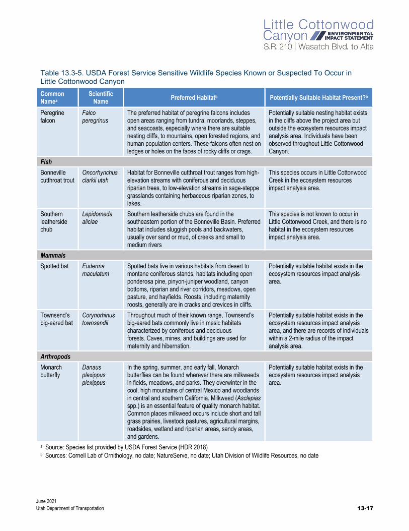
USDA Forest Service Sensitive Species. Representatives from the Uinta-Wasatch-Cache National Forest provided a list of 18 Forest Service sensitive wildlife species for the Intermountain Region, 7 of which they stated do not have any habitat in the impact analysis area: bighorn sheep (Ovis canadensis), gray wolf (Canis lupus), boreal owl (Aegolius funereus), greater sage-grouse (Centrocercus urophasianus), great gray owl (Strix nebulosi), Columbian sharp-tailed grouse (Tympanuchus phasianellus columbianus), and Colorado River cutthroat trout (Oncorhynchus clarki pleuriticus). The remaining 11 that are known or suspected to occur in Little Cottonwood Canyon are described in Table 13.3-5. Potentially suitable habitat is present in the canyon for 10 of these 11 species. No habitat is present for northern leatherside chubs. No individuals were identified during the field surveys.
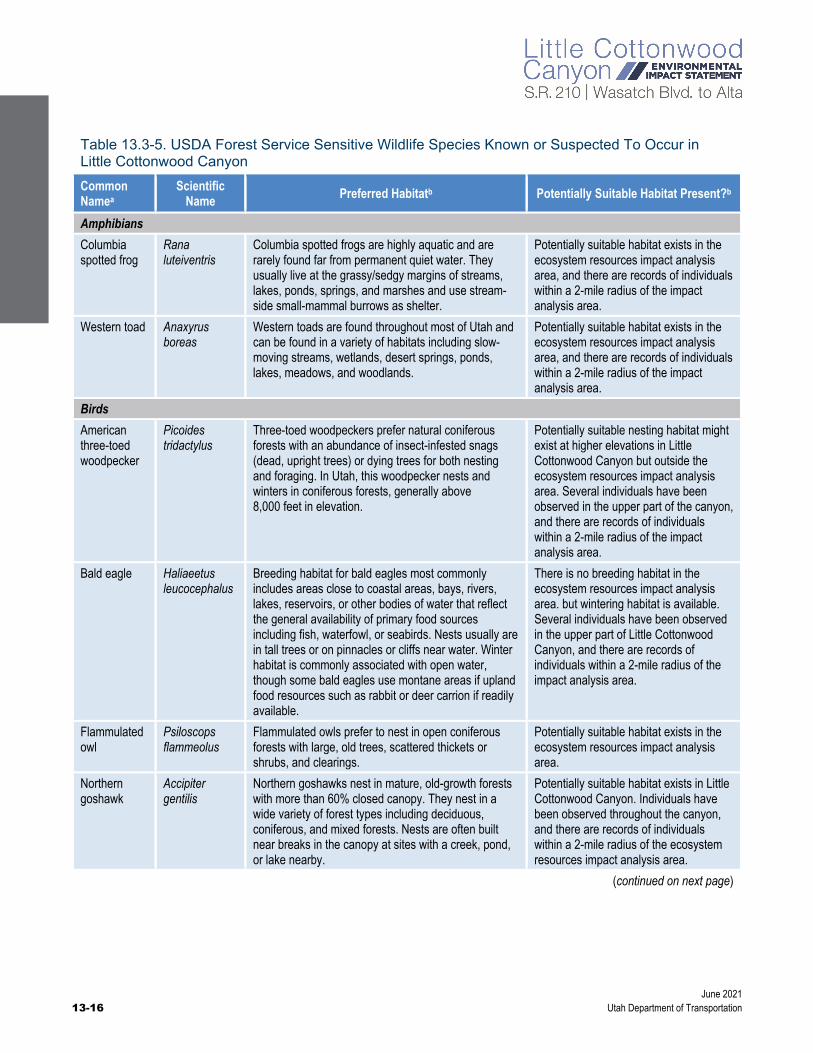
June 2021 13-16 Utah Department of Transportation
Table 13.3-5. USDA Forest Service Sensitive Wildlife Species Known or Suspected To Occur in Little Cottonwood Canyon
Common Namea
Scientific Name
Preferred Habitatb Potentially Suitable Habitat Present?b
Amphibians
Columbia spotted frog
Rana luteiventris
Columbia spotted frogs are highly aquatic and are rarely found far from permanent quiet water. They usually live at the grassy/sedgy margins of streams, lakes, ponds, springs, and marshes and use stream-side small-mammal burrows as shelter.
Potentially suitable habitat exists in the ecosystem resources impact analysis area, and there are records of individuals within a 2-mile radius of the impact analysis area.
Western toad Anaxyrus boreas
Western toads are found throughout most of Utah and can be found in a variety of habitats including slow-moving streams, wetlands, desert springs, ponds, lakes, meadows, and woodlands.
Potentially suitable habitat exists in the ecosystem resources impact analysis area, and there are records of individuals within a 2-mile radius of the impact analysis area.
Birds
American three-toed woodpecker
Picoides tridactylus
Three-toed woodpeckers prefer natural coniferous forests with an abundance of insect-infested snags (dead, upright trees) or dying trees for both nesting and foraging. In Utah, this woodpecker nests and winters in coniferous forests, generally above 8,000 feet in elevation.
Potentially suitable nesting habitat might exist at higher elevations in Little Cottonwood Canyon but outside the ecosystem resources impact analysis area. Several individuals have been observed in the upper part of the canyon, and there are records of individuals within a 2-mile radius of the impact analysis area.
Bald eagle Haliaeetus leucocephalus
Breeding habitat for bald eagles most commonly includes areas close to coastal areas, bays, rivers, lakes, reservoirs, or other bodies of water that reflect the general availability of primary food sources including fish, waterfowl, or seabirds. Nests usually are in tall trees or on pinnacles or cliffs near water. Winter habitat is commonly associated with open water, though some bald eagles use montane areas if upland food resources such as rabbit or deer carrion if readily available.
There is no breeding habitat in the ecosystem resources impact analysis area. but wintering habitat is available. Several individuals have been observed in the upper part of Little Cottonwood Canyon, and there are records of individuals within a 2-mile radius of the impact analysis area.
Flammulated owl
Psiloscops flammeolus
Flammulated owls prefer to nest in open coniferous forests with large, old trees, scattered thickets or shrubs, and clearings.
Potentially suitable habitat exists in the ecosystem resources impact analysis area.
Northern goshawk
Accipiter gentilis
Northern goshawks nest in mature, old-growth forests with more than 60% closed canopy. They nest in a wide variety of forest types including deciduous, coniferous, and mixed forests. Nests are often built near breaks in the canopy at sites with a creek, pond, or lake nearby.
Potentially suitable habitat exists in Little Cottonwood Canyon. Individuals have been observed throughout the canyon, and there are records of individuals within a 2-mile radius of the ecosystem resources impact analysis area.
(continued on next page)
June 2021 Utah Department of Transportation 13-17
Table 13.3-5. USDA Forest Service Sensitive Wildlife Species Known or Suspected To Occur in Little Cottonwood Canyon
Common Namea
Scientific Name
Preferred Habitatb Potentially Suitable Habitat Present?b
Peregrine falcon
Falco peregrinus
The preferred habitat of peregrine falcons includes open areas ranging from tundra, moorlands, steppes, and seacoasts, especially where there are suitable nesting cliffs, to mountains, open forested regions, and human population centers. These falcons often nest on ledges or holes on the faces of rocky cliffs or crags.
Potentially suitable nesting habitat exists in the cliffs above the project area but outside the ecosystem resources impact analysis area. Individuals have been observed throughout Little Cottonwood Canyon.
Fish
Bonneville cutthroat trout
Oncorhynchus clarkii utah
Habitat for Bonneville cutthroat trout ranges from high-elevation streams with coniferous and deciduous riparian trees, to low-elevation streams in sage-steppe grasslands containing herbaceous riparian zones, to lakes.
This species occurs in Little Cottonwood Creek in the ecosystem resources impact analysis area.
Southern leatherside chub
Lepidomeda aliciae
Southern leatherside chubs are found in the southeastern portion of the Bonneville Basin. Preferred habitat includes sluggish pools and backwaters, usually over sand or mud, of creeks and small to medium rivers
This species is not known to occur in Little Cottonwood Creek, and there is no habitat in the ecosystem resources impact analysis area.
Mammals
Spotted bat Euderma maculatum
Spotted bats live in various habitats from desert to montane coniferous stands, habitats including open ponderosa pine, pinyon-juniper woodland, canyon bottoms, riparian and river corridors, meadows, open pasture, and hayfields. Roosts, including maternity roosts, generally are in cracks and crevices in cliffs.
Potentially suitable habitat exists in the ecosystem resources impact analysis area.
Townsend’s big-eared bat
Corynorhinus townsendii
Throughout much of their known range, Townsend’s big-eared bats commonly live in mesic habitats characterized by coniferous and deciduous forests. Caves, mines, and buildings are used for maternity and hibernation.
Potentially suitable habitat exists in the ecosystem resources impact analysis area, and there are records of individuals within a 2-mile radius of the impact analysis area.
Arthropods
Monarch butterfly
Danaus plexippus plexippus
In the spring, summer, and early fall, Monarch butterflies can be found wherever there are milkweeds in fields, meadows, and parks. They overwinter in the cool, high mountains of central Mexico and woodlands in central and southern California. Milkweed (Asclepias spp.) is an essential feature of quality monarch habitat. Common places milkweed occurs include short and tall grass prairies, livestock pastures, agricultural margins, roadsides, wetland and riparian areas, sandy areas, and gardens.
Potentially suitable habitat exists in the ecosystem resources impact analysis area.
a Source: Species list provided by USDA Forest Service (HDR 2018) b Sources: Cornell Lab of Ornithology, no date; NatureServe, no date; Utah Division of Wildlife Resources, no date

June 2021 13-18 Utah Department of Transportation
Migratory Birds. Table 13.3-6 lists the bird species included on the USFWS Information for Planning and Conservation (IPAC) website that could occur near the ecosystem resources impact analysis area (for the consultation letter from USFWS with the official list of these species, see Appendix 13A, Pertinent Correspondence). The table also describes the preferred habitat for each species and states whether there is potentially suitable habitat in the impact analysis area.
Table 13.3-6. Migratory Birds Known To Occur near the Ecosystem Resources Impact Analysis Area
Common Namea
Scientific Name Preferred Habitatb
Potentially Suitable Habitat Present?b
Bald eagle Haliaeetus leucocephalus
Breeding habitat for bald eagles most commonly includes areas close to coastal areas, bays, rivers, lakes, reservoirs, or other bodies of water that reflect the general availability of primary food sources including fish, waterfowl, or seabirds. Nests usually are in tall trees or on pinnacles or cliffs near water. Winter habitat is commonly associated with open water, though some bald eagles use montane areas if upland food resources such as rabbit or deer carrion if readily available.
There is no breeding habitat in the ecosystem resources impact analysis area, but wintering habitat is available. Several individuals have been observed in the upper part of Little Cottonwood Canyon, and there are records of individuals within a 2-mile radius of the impact analysis area.
Black rosy-finch Leucosticte atrata
Black rosy-finches breed above the timberline in alpine tundra using barren, rocky, or grassy areas and cliffs among glaciers or at the bases of snow fields.
Potentially suitable breeding habitat exists in the ecosystem resources impact analysis area.
Black swift Cypseloides niger
Black swifts require waterfalls for nesting; typically the falls are permanent but can be intermittent if they flow throughout the breeding season (June to early September). Nesting sites are typically surrounded by coniferous forests (often mixed conifer or spruce-fir forests), but this varies depending on elevation and aspect, and nest sites can include mountain shrub, aspen, or even alpine components. Streams that create the waterfalls are typically mountain riparian habitats.
Two confirmed breeding locations are known in Utah, neither of which is in Little Cottonwood Canyon. However, there is suitable habitat in the waterfalls in the ecosystem resources impact analysis area, and individuals have been observed in the area.
Brewer's sparrow
Spizella breweri Brewer’s sparrows breed primarily in shrub-steppe habitats in Utah and are considered to be shrub-steppe obligates. They also breed in large sagebrush openings in pinyon-juniper habitat or coniferous forests. Breeding habitats are usually dominated by big sagebrush.
Potentially suitable breeding habitat exists in the lower part of Little Cottonwood Canyon and the foothills above Wasatch Boulevard. Individuals have been observed throughout the canyon.
Brown-capped rosy-finch
Leucosticte australis
Brown-capped rosy-finches prefer barren, rocky, or grassy areas and cliffs among glaciers or above the timberline. This bird usually nests in rock crevices or holes in cliffs. It sometimes nests in mine shafts or old abandoned buildings.
Potentially suitable breeding habitat exists in the ecosystem resources impact analysis area. Individuals have been observed in the area.
(continued on next page)

June 2021 Utah Department of Transportation 13-19
Table 13.3-6. Migratory Birds Known To Occur near the Ecosystem Resources Impact Analysis Area
Common Namea
Scientific Name
Preferred Habitatb Potentially Suitable Habitat Present?b
Golden eagle Aquila chrysaetos
Golden eagles generally inhabit open and semi-open country such as prairies, sagebrush, arctic and alpine tundra, savannah or sparse woodland, and barren areas, especially in hilly or mountainous regions, in areas with sufficient mammalian prey base and near suitable nesting sites. Nests are most often on rock ledges of cliffs.
Potentially suitable breeding habitat exists in the cliffs in the ecosystem resources impact analysis area. Individuals have not been observed in the area.
Green-tailed towhee
Pipilo chlorurus Green-tailed towhees live in dense, shrubby habitat. They usually do not live in unbroken forest but can live in open pinyon-juniper forest or, at high elevations, amid scattered small conifers. They also live in sagebrush shrub-steppe, often intermixed with shrubs and trees such as chokecherry, mountain mahogany, juniper, snowberry, and serviceberry. They can live up to about 10,000 feet elevation.
Potentially suitable breeding habitat exists in the shrubby parts of Little Cottonwood Canyon and the foothills above Wasatch Boulevard. Individuals have been observed throughout the canyon.
Lewis’s woodpecker
Melanerpes lewis
The preferred breeding habitat of Lewis’s woodpeckers consists of open, park-like Ponderosa pine forests as well as burned-over Douglas-fir, mixed conifer, pinyon-juniper, and riparian and oak woodlands. It also lives in the fringes of pine and juniper stands and deciduous forests, especially riparian cottonwoods. Areas with a good understory of grasses and shrubs to support insect prey populations are preferred. Dead trees or stumps are required for nesting.
Potentially suitable habitat exists in Little Cottonwood Canyon. Several individuals have been observed in the canyon.
Olive-sided flycatcher
Contopus cooperi
Olive-sided flycatchers breed in various forest and woodland habitats—taiga, subalpine coniferous forest, mixed coniferous-deciduous forest, burned-over forest, spruce or tamarack bogs and other forested wetlands—and along the forested edges of lakes, ponds, and streams. Most nesting sites contain dead standing trees, which are used as singing and feeding perches. Nests are placed most often in conifers.
Potentially suitable habitat exists in Little Cottonwood Canyon. Individuals have been observed throughout the canyon.
Rufous hummingbird
Selasphorus rufus
The typical breeding habitat for rufous hummingbirds includes coniferous forests, second-growth forests, thickets, and brushy hillsides, with foraging extending into adjacent scrubby areas and meadows with abundant nectar flowers.
Potentially suitable habitat exists in Little Cottonwood Canyon. Individuals have been observed throughout the canyon.
Virginia's warbler Oreothlypis virginiae
The preferred breeding habitat for Virginia’s warblers is in low, brushy areas on dry mountainsides where an herbaceous or woody understory is well-developed. Lower mountain habitats with dense stands of Gambel oak and a relatively high slope are preferred for breeding, although mountain mahogany woodlands, riparian areas, Ponderosa pine forests, and pinyon-juniper woodlands, all with shrubby understories, are also used for breeding. Breeding occasionally occurs in Douglas-fir and aspen habitats with the required shrubby understory.
Potentially suitable habitat exists in Little Cottonwood Canyon. Individuals have been observed throughout the canyon.
(continued on next page)

June 2021 13-20 Utah Department of Transportation
Table 13.3-6. Migratory Birds Known To Occur near the Ecosystem Resources Impact Analysis Area
Common Namea
Scientific Name
Preferred Habitatb Potentially Suitable Habitat Present?b
Williamson’s sapsucker
Sphyrapicus thyroideus
Breeding habitat for Williamson’s sapsuckers includes middle- to high-elevation montane and subalpine coniferous forests—including spruce-fir, Douglas-fir, western larch, lodgepole pine, and Ponderosa pine—and also mixed deciduous-coniferous forest with quaking aspens. Nests are usually in dead or decaying pine, fir, larch, or aspen trees.
Potentially suitable habitat exists in Little Cottonwood Canyon. Several individuals have been observed in the upper part of the canyon.
Willow flycatcher Empidonax traillii
Willow flycatchers are associated with dense riparian deciduous shrub cover separated by open areas. The presence of water (running water, pools, or saturated soils) and willow, alder, or other deciduous riparian shrubs are essential habitat elements. Nests are primarily near slow streams, standing water or seeps, or swampy thickets (especially of willow and buttonbush, but also dogwood, elderberry, hawthorn, rose, tamarisk, and others).
Potentially suitable habitat exists in Little Cottonwood Canyon. Several individuals have been observed in the upper part of the canyon.
a Source: Species list from USFWS (2020b) b Sources: Cornell Lab of Ornithology, no date; NatureServe, no date; Utah Division of Wildlife Resources, no date
13.3.2.3 Waters of the United States
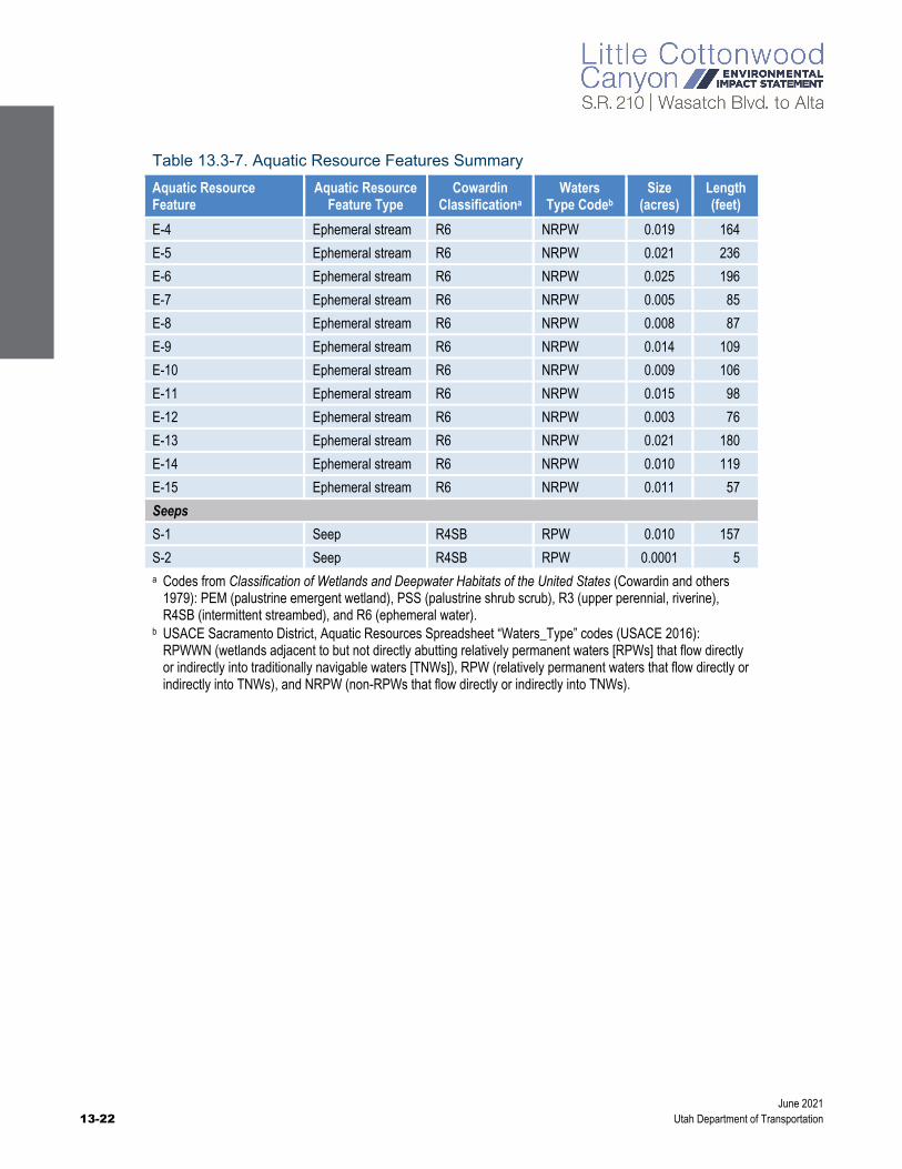
This section summarizes all aquatic resources identified in the area surveyed for aquatic resources. Section 13.3.2.3.4, Jurisdictional Status of Aquatic Resources, identities which of the delineated aquatic resources are subject to USACE’s jurisdiction as waters of the United States. A total of 45 aquatic resource features were identified in the area surveyed for aquatic resources: 13 palustrine wetlands that total 0.84 acre, 4,989 linear feet (2.80 acres) of perennial stream segments (these values include Little Cottonwood Creek and two unnamed perennial streams), 2,820 linear feet (0.44 acre) of intermittent stream segments, two seeps that total 0.01 acre, and 2,129 linear feet (0.25 acre) of ephemeral stream segments.
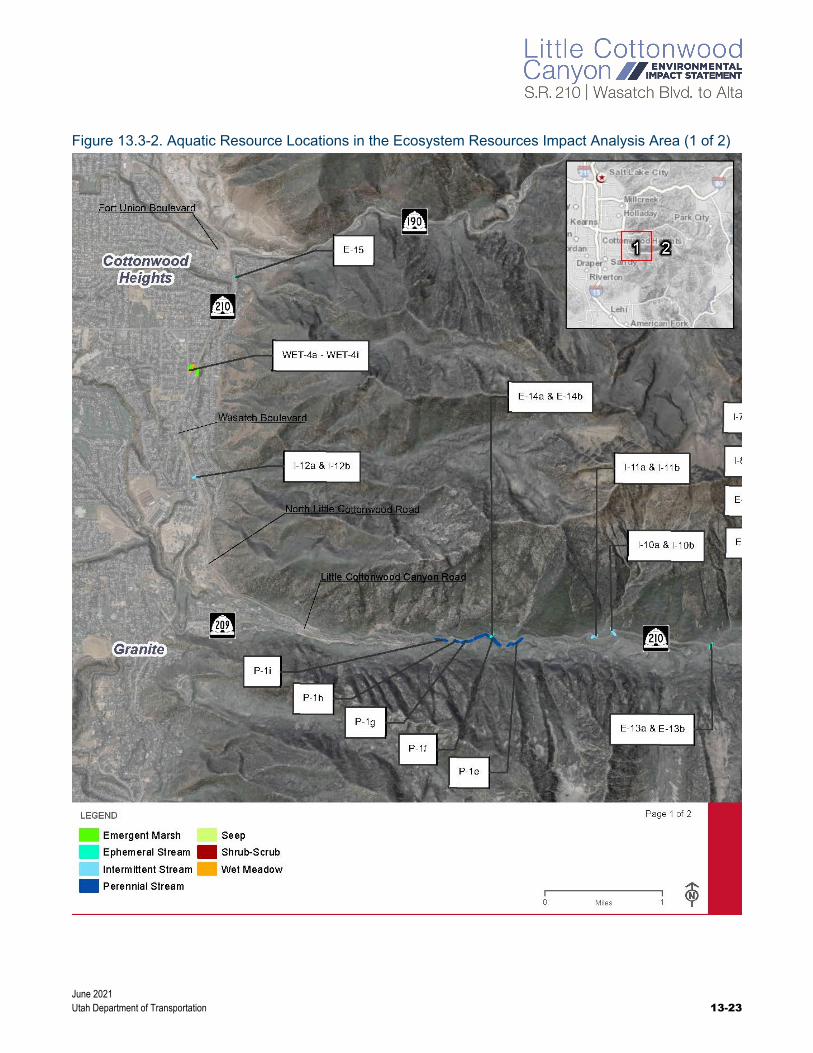
Table 13.3-7 lists each of the aquatic resource features delineated. Figure 13.3-2 and Figure 13.3-3 show the locations of the aquatic resource features. These resource features are described in detail after the table and figures.

June 2021 Utah Department of Transportation 13-21
Table 13.3-7. Aquatic Resource Features Summary
Aquatic Resource Feature
Aquatic Resource Feature Type
Cowardin Classificationa
Waters Type Codeb
Size (acres)
Length (feet)
Wetlands
WET-1 Wet meadow PEM RPWWN 0.015 —
WET-2 Wet meadow PEM RPWWN 0.008 —
WET-3 Wet meadow PEM RPWWN 0.075 —
WET-4a Wet meadow PEM RPWWN 0.020 —
WET-4b Emergent marsh PEM RPWWN 0.097 —
WET-4c Wet meadow PEM RPWWN 0.009 —
WET-4d Shrub-scrub PSS RPWWN 0.047 —
WET-4e Wet meadow PEM RPWWN 0.134 —
WET-4f Wet meadow PEM RPWWN 0.011 —
WET-4g Emergent marsh PEM RPWWN 0.018 —
WET-4h Emergent marsh PEM RPWWN 0.009 —
WET-4i Emergent marsh PEM RPWWN 0.310 —
WET-5 Emergent marsh PEM RPWWN 0.090 —
Streams
Little Cottonwood Creek (P-1a to P-1i)
Perennial stream R3 RPW 2.798 4,989
P-2 Perennial stream R3 RPW 0.070 166
P-3 Perennial stream R3 RPW 0.113 323
I-1 Intermittent stream R4SB RPW 0.021 133
I-2 Intermittent stream R4SB RPW 0.026 142
I-3 Intermittent stream R4SB RPW 0.015 90
I-4 Intermittent stream R4SB RPW 0.080 427
I-5 Intermittent stream R4SB RPW 0.059 545
I-6 Intermittent stream R4SB RPW 0.023 284
I-7 Intermittent stream R4SB RPW 0.012 329
I-8 Intermittent stream R4SB RPW 0.001 45
I-9 Intermittent stream R4SB RPW 0.027 168
I-10 Intermittent stream R4SB RPW 0.057 304
I-11 Intermittent stream R4SB RPW 0.078 169
Deaf Smith Canyon Creek (I-12) Intermittent stream R4SB RPW 0.037 186
E-1 Ephemeral stream R6 NRPW 0.035 331
E-2 Ephemeral stream R6 NRPW 0.011 77
E-3 Ephemeral stream R6 NRPW 0.044 209
(continued on next page)
June 2021 13-22 Utah Department of Transportation
Table 13.3-7. Aquatic Resource Features Summary
Aquatic Resource Feature
Aquatic Resource Feature Type
Cowardin Classificationa
Waters Type Codeb
Size (acres)
Length (feet)
E-4 Ephemeral stream R6 NRPW 0.019 164
E-5 Ephemeral stream R6 NRPW 0.021 236
E-6 Ephemeral stream R6 NRPW 0.025 196
E-7 Ephemeral stream R6 NRPW 0.005 85
E-8 Ephemeral stream R6 NRPW 0.008 87
E-9 Ephemeral stream R6 NRPW 0.014 109
E-10 Ephemeral stream R6 NRPW 0.009 106
E-11 Ephemeral stream R6 NRPW 0.015 98
E-12 Ephemeral stream R6 NRPW 0.003 76
E-13 Ephemeral stream R6 NRPW 0.021 180
E-14 Ephemeral stream R6 NRPW 0.010 119
E-15 Ephemeral stream R6 NRPW 0.011 57
Seeps
S-1 Seep R4SB RPW 0.010 157
S-2 Seep R4SB RPW 0.0001 5 a Codes from Classification of Wetlands and Deepwater Habitats of the United States (Cowardin and others
1979): PEM (palustrine emergent wetland), PSS (palustrine shrub scrub), R3 (upper perennial, riverine), R4SB (intermittent streambed), and R6 (ephemeral water).
b USACE Sacramento District, Aquatic Resources Spreadsheet “Waters_Type” codes (USACE 2016): RPWWN (wetlands adjacent to but not directly abutting relatively permanent waters [RPWs] that flow directly or indirectly into traditionally navigable waters [TNWs]), RPW (relatively permanent waters that flow directly or indirectly into TNWs), and NRPW (non-RPWs that flow directly or indirectly into TNWs).
June 2021 Utah Department of Transportation 13-23
Figure 13.3-2. Aquatic Resource Locations in the Ecosystem Resources Impact Analysis Area (1 of 2)

June 2021 13-24 Utah Department of Transportation
Figure 13.3-3. Aquatic Resource Locations in the Ecosystem Resources Impact Analysis Area (2 of 2)
June 2021 Utah Department of Transportation 13-25
13.3.2.3.1 Wetlands
Three general wetland areas were identified during the aquatic resources survey. One area is located toward the upper extent of the field survey area on a slope just below S.R. 210 near Snowbird Resort, the second is located near Snowbird Resort, and the third is in a stormwater drainage basin at the park-and-ride lot at about 3500 East and Wasatch Boulevard. Based on the observed wetland characteristics and on the Cowardin Classification System (Cowardin and others 1979), all delineated wetlands are classified as palustrine.
13.3.2.3.2 Streams
Perennial streams that were delineated include Little Cottonwood Creek (segments P-1a to P-1i), which is formed by its headwater tributaries toward the top of Little Cottonwood Canyon. This creek flows down the canyon into the Salt Lake Valley and is a tributary to the Jordan River. In addition, perennial stream P-2 is a tributary to Little Cottonwood Creek that drains Grizzly Gulch in the upper part of the canyon, and perennial stream P-3 runs near Snowbird and passes under the Alta Bypass Road into Little Cottonwood Creek.
Segments of 12 intermittent and 15 ephemeral streams were also delineated. All but one ephemeral stream are tributaries to Little Cottonwood Creek. Most of the delineated streams cross S.R. 210, and a segment was delineated on each side of S.R. 210 with a culvert in between. One of the 12 delineated intermittent streams is a named stream, and none of the 15 delineated ephemeral streams are named streams.
Deaf Smith Canyon Creek (also known as Little Willow Creek) is a named intermittent tributary to Little Cottonwood Creek that drains Deaf Smith Canyon, which is located between Big Cottonwood Canyon and Little Cottonwood Canyon. Deaf Smith Canyon Creek crosses S.R. 210/Wasatch Boulevard 1 mile north of the entrance to Little Cottonwood Canyon near Golden Hills Avenue.
The other 11 intermittent streams are located in Little Cottonwood Canyon. Fourteen of the 15 delineated ephemeral streams are located in Little Cottonwood Canyon. One ephemeral stream (E-15) is located near the northern end of the field survey area in a drainage below Ferguson Canyon. This ephemeral stream is a tributary to Big Cottonwood Creek. The other 14 ephemeral streams are tributaries to Little Cottonwood Creek.
13.3.2.3.3 Seeps
Two seeps (S-1 and S-2) were delineated in the field survey area. Seep S-1 begins where it discharges from the toe of a slope just north of S.R. 210 and flows along the northern edge of this road for about 157 linear feet until it joins intermittent stream I-3 at a culvert that crosses under the road. Seep S-2 is small feature that begins southeast of intermittent stream I-6 and drains into Little Cottonwood Creek. Seep S-2 is 5 linear feet (0.0001 acre) within the ecosystem resources impact analysis area.

June 2021 13-26 Utah Department of Transportation
13.3.2.3.4 Jurisdictional Status of Aquatic Resources
All perennial and intermittent streams in the ecosystem resources impact analysis area eventually drain to the Jordan River, which drains to the Great Salt Lake. The Great Salt Lake is a traditional navigable water (TNW). USACE would assert jurisdiction over these delineated waterways as waters of the United States because they meet the definition of tributaries, per 40 CFR Section 120.2, as a river or stream that contributes surface water to jurisdictional waters. Based on the Navigable Waters Protection Rule definition of waters of the United States in 33 CFR Part 328 and 40 CFR Section 120.2:
Ephemeral streams are non-jurisdictional waters.
Seeps that do not pertain to tributaries or adjacent wetlands are non-jurisdictional waters because groundwater is non-jurisdictional.
Only wetlands that meet the definition of adjacent wetlands are considered jurisdictional waters of the United States. The two wetland areas located near Snowbird would not be considered jurisdictional because they are not adjacent to a TNW or tributary.
The wetland area in the stormwater drainage basin would not be considered jurisdictional because (1) it does not meet the definition of adjacent wetland and (2) it is situated with a stormwater control feature that is constructed in upland and designed to manage stormwater runoff.
The official jurisdictional status of delineated aquatic resources is determined by USACE. If an approved jurisdictional determination is requested, USACE would decide the jurisdictional status of delineated aquatic resources under the regulations and guidance that are in effect when the request is made. Once an alternative is selected in the Record of Decision, UDOT will work with USACE regarding appropriate permit requirements and jurisdiction determination.
13.3.2.4 Riparian Habitat Conservation Areas
In September 2020, UDOT conducted a field verification and assessment of RHCAs within the footprints of the action alternatives. To identify RHCA areas, UDOT used stream delineation data and buffered each resource based on the RHCA categories described in Section 13.3.1, Methodology. These resources included Little Cottonwood Creek (a Category 1 stream), which was buffered 300 feet on either side of the stream; Category 2 streams, which were buffered 150 feet on either side of the stream; Category 3 features, which were buffered 150 feet from the edge of the feature; and Category 4 features, which were buffered 100 feet on either side of the feature.
Based on the field survey, 43.09 acres of RHCAs intersect the footprints of the action alternatives. Of these 43.09 acres, 2.30 acres contain riparian habitat and qualify as RHCA habitat. These habitats were generally dominated by Bebb’s willow (Salix bebbiana), narrow-leaf cottonwood, and dogwood. Riparian areas appeared to be in good condition and undisturbed, except where near the S.R. 210 road shoulder and road crossings. These areas often contained boulders and gravel from road stabilization projects (for more information, see Appendix 13B, Riparian Habitat Conservation Areas Assessment Memorandum).
June 2021 Utah Department of Transportation 13-27
13.4 Environmental Consequences and Mitigation Measures
This section discusses the direct impacts and indirect effects of the project alternatives on the ecosystem resources in the ecosystem resources impact analysis area.
13.4.1 No-Action Alternative This section describes the impacts to ecosystem resources from the No-Action Alternative in the Wasatch Boulevard segment of S.R. 210, in the segment of S.R. 210 from North Little Cottonwood Road to the town of Alta, at the gravel pit, and at the park-and-ride lot at 9400 South and Highland Drive.
13.4.1.1 S.R. 210 – Wasatch Boulevard
With the No-Action Alternative, there would be no impacts to ecosystem resources in the Wasatch Boulevard segment of S.R. 210 as a result of the project. Vegetation, terrestrial and aquatic wildlife, special-status wildlife species, and waters of the United States would continue to be affected by current and future use of the roadway. These impacts would include the effects of road noise on wildlife and wildlife-vehicle collisions on the existing roadway.
13.4.1.2 S.R. 210 – North Little Cottonwood Road to Alta
With the No-Action Alternative, there would be no impacts to the ecosystem resources in the North Little Cottonwood Road to Alta segment of S.R. 210 as a result of the project. Vegetation, terrestrial and aquatic wildlife, special-status wildlife species, waters of the United States, and RHCAs would continue to be affected by current and future use of the roadway and by roadside parking. These impacts would include the effects of road noise on wildlife and wildlife-vehicle collisions on the existing roadway.
During the hour with the 30th-highest hourly traffic demand, the number of vehicles is projected to increase from 1,061 in 2018 to 1,555 in 2050 with the No-Action Alternative. This increase in the number of vehicles could increase the number of collisions with large mammals and increase the barrier effect of S.R. 210, whereby the road restricts the movements of wildlife.
With increased traffic and recreation use, soils would be more disturbed, which could increase the spread of noxious weeds. With the continuation of roadside parking, vegetation, terrestrial and aquatic wildlife, special-status wildlife species, and waters of the United States would continue to be affected by activities (such as hiking or parking on the roadside) that disturb wildlife, trample vegetation, and increase soil disturbance and the spread of noxious weeds.
What is the 30th-highest hourly traffic demand?
The 30th-highest hourly traffic demand refers to the hour over an entire year with the projected 30th-highest traffic volume on S.R. 210 in Little Cottonwood Canyon. For more information, see Section 7.2.1.2, S.R. 210 – North Little Cottonwood Road to Alta, in Chapter 7, Traffic and Transportation.
June 2021 13-28 Utah Department of Transportation
13.4.1.3 Mobility Hubs
13.4.1.3.1 Gravel Pit
The gravel pit is an aggregate mine and consists mostly of disturbed dirt. With the No-Action Alternative, the area currently being used for aggregate mining would likely be developed with commercial and residential uses. Currently, Cottonwood Heights City is revising zoning to allow a mix of commercial and residential uses. There are no ecosystem resources at this site.
13.4.1.3.2 9400 South and Highland Drive
With the No-Action Alternative, the existing park-and-ride lot at 9400 South and Highland Drive would continue to operate as it does currently. There are no ecosystem resources at this site.
13.4.2 Enhanced Bus Service Alternative This section describes the impacts to ecosystem resources from the Enhanced Bus Service Alternative, which includes improvements to the Wasatch Boulevard segment of S.R. 210, two mobility hubs, avalanche mitigation alternatives, trailhead parking alternatives, and the No Winter Parking Alternative.
13.4.2.1 S.R. 210 – Wasatch Boulevard
This section describes the impacts to ecosystem resources from the Imbalanced-lane Alternative and the Five-lane Alternative, which would both widen the Wasatch Boulevard segment of S.R. 210.
13.4.2.1.1 Imbalanced-lane Alternative
Vegetation
The Imbalanced-lane Alternative would convert about 35 acres of mostly developed and/or disturbed and agricultural land to transportation use. Vegetation would be converted as a result of clearing, excavating, and grading to widen Wasatch Boulevard from two travel lanes to three travel lanes. The habitat that would be converted is primarily disturbed roadside habitat that has already been degraded and provides little habitat value to wildlife.
Construction equipment could disturb soils and create favorable conditions for noxious weeds to become established. Noxious weeds that are present in the disturbed areas of the ecosystem resources impact analysis area could spread into areas affected by roadway construction.
What is the gravel pit?
The gravel pit is an existing aggregate (gravel) mine located on the east side of Wasatch Boulevard between 6200 South and Fort Union Boulevard.
Table 13.4-1. Impacts to Vegetation in the Ecosystem Resources Impact Analysis Area from the Imbalanced-lane Alternative with the Enhanced Bus Service Alternative
Habitat Type Acres in Impact Analysis Area Acres Converted
Developed 876.1 34.73
Forest/woodland 6,620.5 0.00
Shrubland 2,412.0 0.02
Meadow/grassland 1,173.7 0.00
Bedrock 6,688.6 0.00
Open water 31.0 0.00
Total 17,801.9 34.75
June 2021 Utah Department of Transportation 13-29
There is no suitable habitat for USDA Forest Service sensitive species in this segment of S.R. 210.
Table 13.4-1 above summarizes the impacts to vegetation from the Imbalanced-lane Alternative.
Terrestrial and Aquatic Wildlife
The Imbalanced-lane Alternative would widen Wasatch Boulevard from two to three travel lanes and add a center median from Fort Union Boulevard to North Little Cottonwood Road. This alternative would convert about 35 acres of mostly developed and agricultural land to transportation use. Impacts to terrestrial and aquatic wildlife would be minor since this segment of S.R. 210 is already highly developed. The wider road would slightly increase noise and visual disturbance to wildlife near the road. The wider road would also increase the barrier to wildlife crossing Wasatch Boulevard and increase their avoidance of the highway. The Utah Wildlife-Vehicle Collision Reporter documents seven wildlife-vehicle collisions on Wasatch Boulevard during a 2-year period (UDOT and Utah Division of Wildlife Resources, no date). The wider roadway could increase the number of wildlife-vehicle collisions in this segment of S.R. 210.
No federally threatened, endangered, or candidate species or habitat was identified in the ecosystem resources impact analysis area; therefore, no impacts to threatened and endangered species would occur as a result of the Imbalanced-lane Alternative. UDOT has determined there would be no effect on threatened and endangered species from the action alternatives due to the lack of suitable habitat. A copy of the consultation letter from USFWS is included in Appendix 13A, Pertinent Correspondence. There is no suitable habitat for USDA Forest Service sensitive species in this segment of S.R. 210.
Short-term, local impacts to wildlife would occur during construction of any of the action alternatives. Removal of vegetation and increased noise and activity from construction could temporarily and/or permanently displace individual animals from these areas. Project construction could temporarily displace wildlife from the active construction areas because of increased noise, construction lighting, and human activity during construction. However, wildlife that currently occupies the area or uses the adjacent areas for foraging is likely habituated to noise and human disturbance due to the disturbed nature of the area, so the impacts from construction noise and lighting and displacement would be minor.
Impacts to migratory birds and raptors would include a minor loss of disturbed roadside habitat and increased noise and visual disturbance. Construction activities could take migratory birds and displace birds from habitat near construction areas. If construction takes place during the nesting season for migratory birds and raptors (April 1 through August 15), birds could lose or abandon their nests. Disturbance by construction workers and equipment might be substantial enough to cause stress to nesting birds and cause birds to abandon their nests and their young to be killed by predators. To mitigate these potential impacts to birds, including those protected by the Migratory Bird Treaty Act and in accordance with Executive Order 13186, UDOT will implement the mitigation measures in Section 13.4.7, Mitigation Measures.
Impacts to aquatic species from constructing the Imbalanced-lane Alternative would be minor because there would be few aquatic impacts (0.02 acre) from this alternative, the habitat impacts would be mostly in existing channelized areas next to the existing road, and the duration of construction would be short. The impacts from construction could include increased sedimentation and reduced water quality. Implementing water quality best management practices (BMPs) during construction would reduce these short-term impacts. As part of the Imbalanced-lane Alternative, UDOT would build a stormwater drainage and collection system, which would improve water quality compared to the conditions with the No-Action Alternative (see Section 12.4.3.1, S.R. 210 – Wasatch Boulevard, in Chapter 12, Water Resources). The long-term impacts

June 2021 13-30 Utah Department of Transportation
to aquatic species from increased sedimentation and reduced water quality as a result of the increased amount of impervious surface should be minor with the implementation of BMPs to reduce sedimentation.
Waters of the United States
The Imbalanced-lane Alternative would convert 0.02 acre of intermittent stream segments I12-a and I-12b to transportation use [see Figure 13.3-2 above, Aquatic Resource Locations in the Ecosystem Resources Impact Analysis Area (1 of 2)]. Widening Wasatch Boulevard would require replacing or extending the culvert carrying Deaf Smith Canyon Creek under Wasatch Boulevard. No other aquatic resources would be affected. The design of this alternative avoids or minimizes impacts to aquatic resources whenever possible while still allowing the alternative to meet the purpose of and need for the project. The cross section includes a wall at this location to reduce the roadway footprint (for details about the roadway plans, see Appendix 2B, Wasatch Boulevard Imbalanced-lane Alternative Plans, for Chapter 2, Alternatives).
Indirect Effects. Indirect effects on waters of the United States could occur from sediment discharges associated with stormwater, erosion, hydrologic modifications, and the establishment of noxious weeds. Most of these indirect effects could be reduced or eliminated through the mitigation measures listed in Section 13.4.7, Mitigation Measures.
Riparian Habitat Conservation Areas
Wasatch Boulevard is located outside National Forest System lands, and no riparian areas are classified for this segment of S.R. 210.
13.4.2.1.2 Five-lane Alternative
The Five-lane Alternative would add one additional travel lane, or about 12 feet more pavement, on Wasatch Boulevard compared to the Imbalanced-lane Alternative. Overall, the impacts from the Five-lane Alternative to vegetation, terrestrial and aquatic wildlife, and waters of the United States would be similar to those from the Imbalanced-lane Alternative. With the Five-lane Alternative, about 35.32 acres of vegetation would be converted to transportation use versus 34.75 acres with the Imbalanced-lane Alternative. The Five-lane Alternative would have the same impacts to waters of the United States, with 0.02 acre of impacts to intermittent streams. Wasatch Boulevard is located outside National Forest System lands, and riparian areas are not classified for this segment of S.R. 210.
13.4.2.2 S.R. 210 – North Little Cottonwood Road to Alta
With the Enhanced Bus Service Alternative, S.R. 210 would not be widened from North Little Cottonwood Road to the town of Alta. The impacts in this segment would be similar to those from the No-Action Alternative, except that tolling (including the tolling gantry) and the enhanced bus service would be implemented. As a result, the number of vehicles using this segment of S.R. 210 in 2050 would decrease by about 30% during the winter from late November through mid-April. This reduction in vehicle use could decrease the number of vehicle collisions with large mammals compared to the No-Action Alternative.
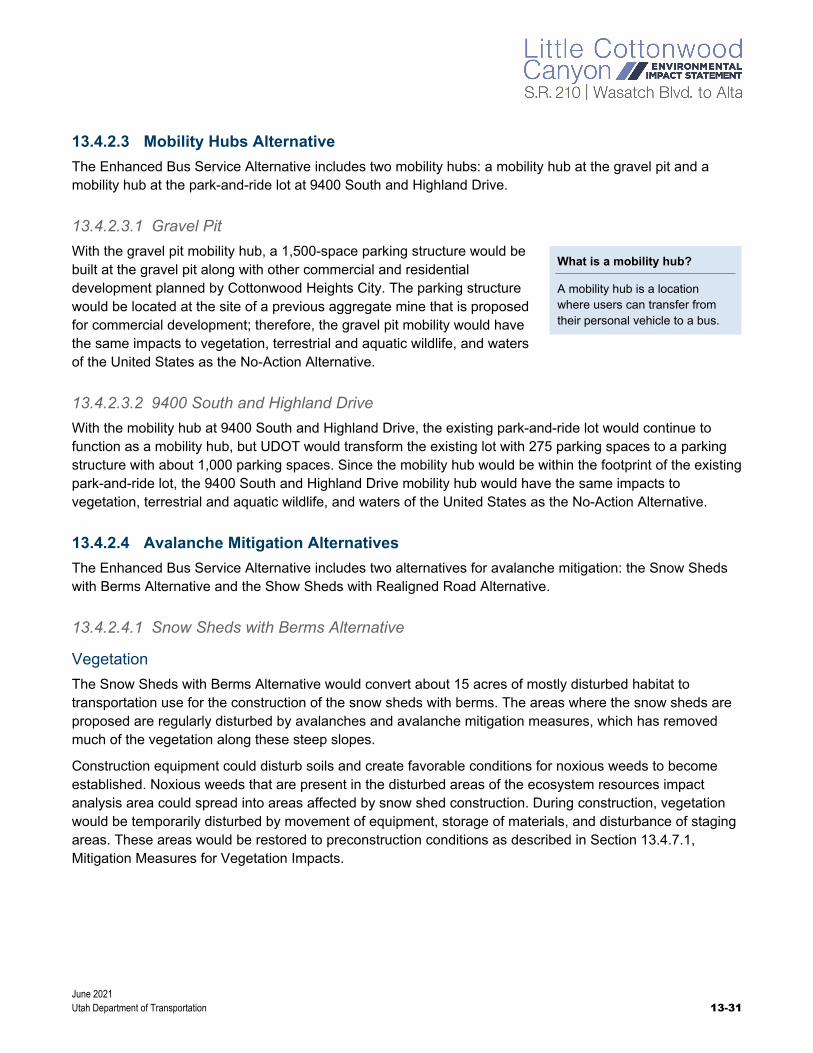
June 2021 Utah Department of Transportation 13-31
13.4.2.3 Mobility Hubs Alternative
The Enhanced Bus Service Alternative includes two mobility hubs: a mobility hub at the gravel pit and a mobility hub at the park-and-ride lot at 9400 South and Highland Drive.
13.4.2.3.1 Gravel Pit
With the gravel pit mobility hub, a 1,500-space parking structure would be built at the gravel pit along with other commercial and residential development planned by Cottonwood Heights City. The parking structure would be located at the site of a previous aggregate mine that is proposed for commercial development; therefore, the gravel pit mobility would have the same impacts to vegetation, terrestrial and aquatic wildlife, and waters of the United States as the No-Action Alternative.
13.4.2.3.2 9400 South and Highland Drive
With the mobility hub at 9400 South and Highland Drive, the existing park-and-ride lot would continue to function as a mobility hub, but UDOT would transform the existing lot with 275 parking spaces to a parking structure with about 1,000 parking spaces. Since the mobility hub would be within the footprint of the existing park-and-ride lot, the 9400 South and Highland Drive mobility hub would have the same impacts to vegetation, terrestrial and aquatic wildlife, and waters of the United States as the No-Action Alternative.
13.4.2.4 Avalanche Mitigation Alternatives
The Enhanced Bus Service Alternative includes two alternatives for avalanche mitigation: the Snow Sheds with Berms Alternative and the Show Sheds with Realigned Road Alternative.
13.4.2.4.1 Snow Sheds with Berms Alternative
Vegetation
The Snow Sheds with Berms Alternative would convert about 15 acres of mostly disturbed habitat to transportation use for the construction of the snow sheds with berms. The areas where the snow sheds are proposed are regularly disturbed by avalanches and avalanche mitigation measures, which has removed much of the vegetation along these steep slopes.
Construction equipment could disturb soils and create favorable conditions for noxious weeds to become established. Noxious weeds that are present in the disturbed areas of the ecosystem resources impact analysis area could spread into areas affected by snow shed construction. During construction, vegetation would be temporarily disturbed by movement of equipment, storage of materials, and disturbance of staging areas. These areas would be restored to preconstruction conditions as described in Section 13.4.7.1, Mitigation Measures for Vegetation Impacts.
What is a mobility hub?
A mobility hub is a location where users can transfer from their personal vehicle to a bus.
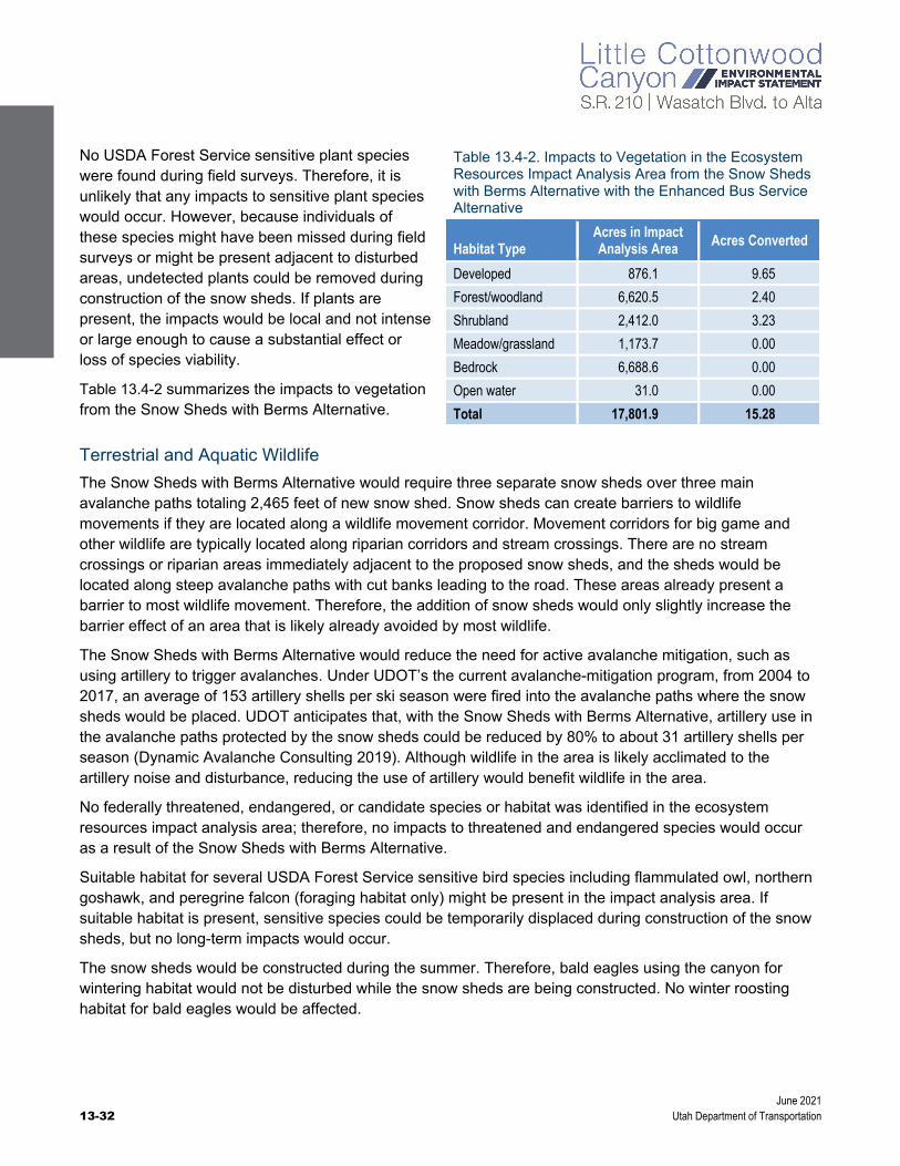
June 2021 13-32 Utah Department of Transportation
No USDA Forest Service sensitive plant species were found during field surveys. Therefore, it is unlikely that any impacts to sensitive plant species would occur. However, because individuals of these species might have been missed during field surveys or might be present adjacent to disturbed areas, undetected plants could be removed during construction of the snow sheds. If plants are present, the impacts would be local and not intense or large enough to cause a substantial effect or loss of species viability.
Table 13.4-2 summarizes the impacts to vegetation from the Snow Sheds with Berms Alternative.
Terrestrial and Aquatic Wildlife
The Snow Sheds with Berms Alternative would require three separate snow sheds over three main avalanche paths totaling 2,465 feet of new snow shed. Snow sheds can create barriers to wildlife movements if they are located along a wildlife movement corridor. Movement corridors for big game and other wildlife are typically located along riparian corridors and stream crossings. There are no stream crossings or riparian areas immediately adjacent to the proposed snow sheds, and the sheds would be located along steep avalanche paths with cut banks leading to the road. These areas already present a barrier to most wildlife movement. Therefore, the addition of snow sheds would only slightly increase the barrier effect of an area that is likely already avoided by most wildlife.
The Snow Sheds with Berms Alternative would reduce the need for active avalanche mitigation, such as using artillery to trigger avalanches. Under UDOT’s the current avalanche-mitigation program, from 2004 to 2017, an average of 153 artillery shells per ski season were fired into the avalanche paths where the snow sheds would be placed. UDOT anticipates that, with the Snow Sheds with Berms Alternative, artillery use in the avalanche paths protected by the snow sheds could be reduced by 80% to about 31 artillery shells per season (Dynamic Avalanche Consulting 2019). Although wildlife in the area is likely acclimated to the artillery noise and disturbance, reducing the use of artillery would benefit wildlife in the area.
No federally threatened, endangered, or candidate species or habitat was identified in the ecosystem resources impact analysis area; therefore, no impacts to threatened and endangered species would occur as a result of the Snow Sheds with Berms Alternative.
Suitable habitat for several USDA Forest Service sensitive bird species including flammulated owl, northern goshawk, and peregrine falcon (foraging habitat only) might be present in the impact analysis area. If suitable habitat is present, sensitive species could be temporarily displaced during construction of the snow sheds, but no long-term impacts would occur.
The snow sheds would be constructed during the summer. Therefore, bald eagles using the canyon for wintering habitat would not be disturbed while the snow sheds are being constructed. No winter roosting habitat for bald eagles would be affected.
Table 13.4-2. Impacts to Vegetation in the Ecosystem Resources Impact Analysis Area from the Snow Sheds with Berms Alternative with the Enhanced Bus Service Alternative
Habitat Type Acres in Impact Analysis Area Acres Converted
Developed 876.1 9.65
Forest/woodland 6,620.5 2.40
Shrubland 2,412.0 3.23
Meadow/grassland 1,173.7 0.00
Bedrock 6,688.6 0.00
Open water 31.0 0.00
Total 17,801.9 15.28

June 2021 Utah Department of Transportation 13-33
Impacts to migratory birds and raptors would include a loss of 2.40 acres of forested habitat and 3.23 acres of shrubland. However, the habitat that would be converted to transportation use is disturbed roadside habitat on a steep slope. Construction activities could take migratory birds and displace birds from habitat near construction areas. If construction takes place during the nesting season for migratory birds and raptors (March 15 through July 31), birds could lose or abandon their nests. Disturbance by construction workers and equipment might be substantial enough to cause stress to nesting birds and cause birds to abandon their nests and their young to be killed by predators. To mitigate these potential impacts to birds, including those protected by the Migratory Bird Treaty Act and in accordance with Executive Order 13186, UDOT will implement the mitigation measures in Section 13.4.7, Mitigation Measures.
Short-term, local impacts to wildlife would occur during construction of the snow sheds. Removal of vegetation and increased noise and activity from construction could temporarily and/or permanently displace individual animals from these areas. Project construction could temporarily displace wildlife from the active construction areas because of increased noise and human activity during construction. However, wildlife that currently occupies the area or uses the adjacent areas for foraging is likely habituated to noise and human disturbance due to the presence of S.R. 210 and heavy recreation in the area, so the impacts of construction noise and disturbance and displacement of wildlife would be minor.
Water quality impacts to aquatic species from constructing the snow sheds would be minor and brief. These impacts from construction include increased sedimentation and reduced water quality. Implementing water quality BMPs during construction would reduce these impacts.
Waters of the United States
The Snow Sheds with Berms Alternative would convert 0.01 acre of ephemeral stream segments E-10 and E-11 to transportation use [see Figure 13.3-2 above, Aquatic Resource Locations in the Ecosystem Resources Impact Analysis Area (1 of 2)]. Constructing the snow sheds would require placing or extending the culverts carrying both ephemeral streams under S.R. 210. However, ephemeral streams are exempt from jurisdiction as waters of the United States under the Navigable Waters Protection Rule. No other aquatic resources would be affected. The design of this alternative avoids or minimizes impacts to aquatic resources whenever possible while still allowing the alternative to meet the purpose of and need for the project.
Indirect Effects. Indirect effects on waters of the United States could occur from sediment discharges associated with stormwater, erosion, hydrologic modifications, and the establishment of noxious weeds. Most of these indirect effects could be reduced or eliminated through the mitigation measures listed in Section 13.4.7, Mitigation Measures.
Riparian Habitat Conservation Areas
The Snow Sheds with Berms Alternative would permanently convert 0.23 acre of riparian habitat classified as RHCA to transportation use. Effects on riparian areas would occur only at culvert crossings. Once the culverts are installed, disturbed areas around the culverts would be revegetated.

June 2021 13-34 Utah Department of Transportation
13.4.2.4.2 Snow Sheds with Realigned Road Alternative
The impacts from the Snow Sheds with Realigned Road Alternative would be similar to those from the Snow Sheds with Berms Alternative except that realigning S.R. 210 would remove curves in the snow sheds and thus improve vehicle safety. With the Snow Sheds with Realigned Road Alternative, about 18.5 acres of mostly developed habitat would be permanently converted to transportation use versus 15.28 acres with the Snow Sheds with Berms Alternative. The impacts to waters of the United States would be the same. This alternative would convert 0.14 acre of riparian habitat classified as RHCA to transportation use.
13.4.2.5 Trailhead Parking Alternatives
The Enhanced Bus Service Alternative includes three alternatives to address trailhead parking:
Trailhead Improvements and No S.R. 210 Roadside Parking within ¼ Mile of Trailheads Alternative
Trailhead Improvements and No Roadside Parking from S.R. 209/S.R. 210 Intersection to Snowbird Entry 1 Alternative
No Trailhead Improvements and No Roadside Parking from S.R. 209/S.R. 210 Intersection to Snowbird Entry 1 Alternative
13.4.2.5.1 Trailhead Improvements and No S.R. 210 Roadside Parking within ¼ Mile of Trailheads Alternative
Vegetation
This alternative would reduce the number of parking spaces in Little Cottonwood Canyon from 528 to 511. This alternative would convert about 7 acres of forest/woodland, shrubland, and developed and/or disturbed habitat to transportation use. All of the trailhead parking areas except the Bridge Trailhead (that is, the Lisa Falls, Gate Buttress, and White Pine Trailheads) would be expanded immediately adjacent to the existing trailhead parking lots. The Bridge Trailhead would include a new parking area away from the existing trailhead but immediately adjacent to S.R. 210. With improved parking, the appropriate number of restrooms would be installed for the number of spaces. In addition, the “spider web” trails caused by roadside parking would be eliminated, thereby reducing vegetation trampling along the roadside parking areas.
Construction equipment could disturb soils and create favorable conditions for noxious weeds to become established. Noxious weeds that are present in the disturbed areas of the ecosystem resources impact analysis area could spread into areas affected by roadway construction. During construction, the construction contractor would store materials and locate staging areas on previously disturbed areas, and these practices would reduce the spread of noxious weeds.
Construction equipment could disturb soils and create favorable conditions for noxious weeds to become established. Noxious weeds that are present in the disturbed areas of the ecosystem resources impact analysis area could spread into areas affected by trailhead improvements. During construction, vegetation would be temporarily disturbed by movement of equipment, storage of materials, and disturbance of staging areas. These areas would be restored to preconstruction conditions as described in Section 13.4.7.1, Mitigation Measures for Vegetation Impacts.
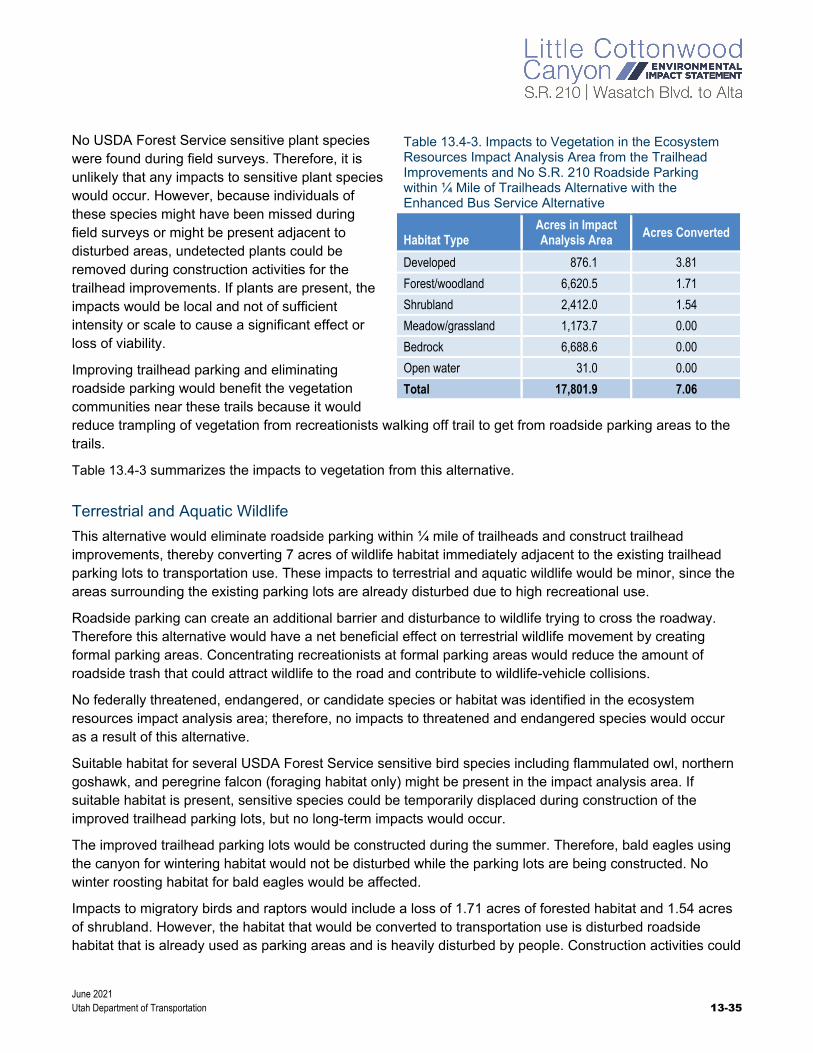
June 2021 Utah Department of Transportation 13-35
No USDA Forest Service sensitive plant species were found during field surveys. Therefore, it is unlikely that any impacts to sensitive plant species would occur. However, because individuals of these species might have been missed during field surveys or might be present adjacent to disturbed areas, undetected plants could be removed during construction activities for the trailhead improvements. If plants are present, the impacts would be local and not of sufficient intensity or scale to cause a significant effect or loss of viability.
Improving trailhead parking and eliminating roadside parking would benefit the vegetation communities near these trails because it would reduce trampling of vegetation from recreationists walking off trail to get from roadside parking areas to the trails.
Table 13.4-3 summarizes the impacts to vegetation from this alternative.
Terrestrial and Aquatic Wildlife
This alternative would eliminate roadside parking within ¼ mile of trailheads and construct trailhead improvements, thereby converting 7 acres of wildlife habitat immediately adjacent to the existing trailhead parking lots to transportation use. These impacts to terrestrial and aquatic wildlife would be minor, since the areas surrounding the existing parking lots are already disturbed due to high recreational use.
Roadside parking can create an additional barrier and disturbance to wildlife trying to cross the roadway. Therefore this alternative would have a net beneficial effect on terrestrial wildlife movement by creating formal parking areas. Concentrating recreationists at formal parking areas would reduce the amount of roadside trash that could attract wildlife to the road and contribute to wildlife-vehicle collisions.
No federally threatened, endangered, or candidate species or habitat was identified in the ecosystem resources impact analysis area; therefore, no impacts to threatened and endangered species would occur as a result of this alternative.
Suitable habitat for several USDA Forest Service sensitive bird species including flammulated owl, northern goshawk, and peregrine falcon (foraging habitat only) might be present in the impact analysis area. If suitable habitat is present, sensitive species could be temporarily displaced during construction of the improved trailhead parking lots, but no long-term impacts would occur.
The improved trailhead parking lots would be constructed during the summer. Therefore, bald eagles using the canyon for wintering habitat would not be disturbed while the parking lots are being constructed. No winter roosting habitat for bald eagles would be affected.
Impacts to migratory birds and raptors would include a loss of 1.71 acres of forested habitat and 1.54 acres of shrubland. However, the habitat that would be converted to transportation use is disturbed roadside habitat that is already used as parking areas and is heavily disturbed by people. Construction activities could
Table 13.4-3. Impacts to Vegetation in the Ecosystem Resources Impact Analysis Area from the Trailhead Improvements and No S.R. 210 Roadside Parking within ¼ Mile of Trailheads Alternative with the Enhanced Bus Service Alternative
Habitat Type Acres in Impact Analysis Area Acres Converted
Developed 876.1 3.81
Forest/woodland 6,620.5 1.71
Shrubland 2,412.0 1.54
Meadow/grassland 1,173.7 0.00
Bedrock 6,688.6 0.00
Open water 31.0 0.00
Total 17,801.9 7.06
June 2021 13-36 Utah Department of Transportation
take migratory birds and displace birds from habitat near construction areas. If construction takes place during the nesting season for migratory birds and raptors (April 1 through August 15), birds could lose or abandon their nests. Disturbance by construction workers and equipment might be substantial enough to cause stress to nesting birds and cause birds to abandon their nests and their young to be killed by predators. To mitigate these potential impacts to birds, including those protected by the Migratory Bird Treaty Act and in accordance with Executive Order 13186, UDOT will implement the mitigation measures in Section 13.4.7, Mitigation Measures.
Short-term, local impacts to wildlife would occur during construction of the improved trailhead parking lots. Removal of vegetation and increased noise and activity from construction could temporarily and/or permanently displace individual animals from these areas. Project construction could temporarily displace wildlife from the active construction areas because of increased noise and human activity during construction. However, wildlife that currently occupies the area or uses the adjacent areas for foraging is likely habituated to noise and human disturbance due to the presence of S.R. 210 and recreation in the area, so the impacts of construction noise and disturbance and displacement of wildlife would be minor.
Impacts to aquatic species from constructing the improved trailhead parking lots would be minor and brief and will be minimized through construction BMPs identified in a stormwater pollution prevention plan. These impacts from construction include increased sedimentation and reduced water quality. Implementing permanent water quality buffers and BMPs at the trailheads would improve water quality compared to the conditions with the No-Action Alternative.
Waters of the United States
This alternative would convert 0.07 acre of an intermittent stream to transportation use. Expanding the Lisa Falls Trailhead would require replacing or extending the culvert and would convert 0.04 acre of an intermittent stream [segments I-10a and I-10b; see Figure 13.3-3 above, Aquatic Resource Locations in the Ecosystem Resources Impact Analysis Area (2 of 2)]. Expanding the White Pine Trailhead would require placing segments of intermittent streams I-6, I-7a, I-7b, and I-8 in culverts and would convert a total of 0.03 acre. Improvements at the Bridge and Gate Buttress Trailheads would not affect aquatic resources. No other aquatic resources would be affected. The design of this alternative avoids and minimizes impacts to aquatic resources whenever possible while still allowing the alternative to meet the purpose of and need for the project.
Indirect Effects. Indirect effects on waters of the United States could occur from sediment discharges associated with stormwater, erosion, hydrologic modifications, and the establishment of noxious weeds. Most these indirect effects could be reduced or eliminated through the mitigation measures listed in Section 13.4.7, Mitigation Measures.
Riparian Habitat Conservation Areas
This alternative would permanently convert 0.60 acre of riparian habitat classified as RHCA to transportation use. Effects on riparian areas would occur as a result of placing segments of an intermittent stream in culverts at the White Pine Trailhead area. Once the culverts are installed, disturbed areas around the culverts would be revegetated.

June 2021 Utah Department of Transportation 13-37
13.4.2.5.2 Trailhead Improvements and No Roadside Parking from S.R. 209/S.R. 210 Intersection to Snowbird Entry 1 Alternative
This alternative would reduce the number of parking spaces in Little Cottonwood Canyon from 528 to 221. The impacts to vegetation, terrestrial and aquatic wildlife, and waters of the United States from this alternative would be the same as the impacts from the Trailhead Improvements and No S.R. 210 Roadside Parking within ¼ Mile of Trailheads Alternative except that fewer people would have access into the adjacent wilderness areas and National Forest. By formalizing trailhead parking areas and eliminating roadside parking, this alternative would have multiple benefits including eliminating “spider web” trails from roadside parking areas to access the trails and National Forest, reducing roadside trash that could contribute to wildlife-vehicle collisions and the attraction of nuisance wildlife, and installing permanent water quality buffers and BMPs at the trailheads with the effect of improving water quality.
13.4.2.5.3 No Trailhead Improvements and No Roadside Parking from S.R. 209/S.R. 210 Intersection to Snowbird Entry 1 Alternative
This alternative would reduce the number of parking spaces in Little Cottonwood Canyon from 528 to 99. Eliminating roadside parking along S.R. 210 in the canyon would reduce the barrier to wildlife crossing the roadway, prevent wildlife from being attracted to the right of way by trash and food, and allow fewer people access into the adjacent wilderness areas and National Forest. Therefore, this alternative would have the same impacts related to no roadside parking as the Trailhead Improvements and No Roadside Parking from S.R. 209/S.R. 210 Intersection to Snowbird Entry 1 Alternative including net beneficial effects on vegetation and terrestrial and aquatic wildlife and no change to waters of the United States.
13.4.2.6 No Winter Parking Alternative
With the No Winter Parking Alternative, about 230 roadside parking spots that are used near the ski resorts during the winter would be eliminated. The elimination of these parking spots would reduce the barrier to wildlife crossing the roadway and would prevent wildlife from being attracted to the right of way by trash and food. With the elimination of winter roadside parking, there would be a minor benefit to vegetation, terrestrial and aquatic wildlife, and waters of the United States because less sediment would be generated in the watershed as a result of less erosion of the highway shoulders.

June 2021 13-38 Utah Department of Transportation
13.4.3 Enhanced Bus Service in Peak-period Shoulder Lane Alternative This section describes the impacts to ecosystem resources from the Enhanced Bus Service in Peak-period Shoulder Lane Alternative, which includes improvements to the Wasatch Boulevard segment of S.R. 210, improvements to the segment of S.R. 210 from North Little Cottonwood Road to the town of Alta, two mobility hubs, avalanche mitigation alternatives, trailhead parking alternatives, and the No Winter Parking Alternative.
13.4.3.1 S.R. 210 – Wasatch Boulevard
The impacts from the improvements to Wasatch Boulevard with the Enhanced Bus Service in Peak-period Shoulder Lane Alternative would be the same as with the Enhanced Bus Service Alternative.
13.4.3.2 S.R. 210 – North Little Cottonwood Road to Alta
Vegetation
The Enhanced Bus Service in Peak-period Shoulder Lane Alternative would convert about 85 acres of shrubland, forest/woodland, and developed and/or disturbed habitat to transportation use for the peak-period shoulder lanes. The habitat that would be converted is primarily disturbed habitat immediately adjacent to the roadway that is degraded from roadside parking and other disturbance. It provides slight habitat value to wildlife.
Construction equipment could disturb soils and create favorable conditions for noxious weeds to become established. Noxious weeds that are present in the disturbed areas of the ecosystem resources impact analysis area could spread into areas affected by roadway construction. During construction, vegetation would be temporarily disturbed by movement of equipment, storage of materials, and disturbance of staging areas. These areas would be restored to preconstruction conditions as described in Section 13.4.7.1, Mitigation Measures for Vegetation Impacts.
No USDA Forest Service sensitive plant species were found during field surveys. However, the USDA Forest Service provided information regarding known occurrences of some species, as listed in Table 13.3-2 above, USDA Forest Service Sensitive Plant Species and Watch List Species Known or Suspected to Occur in the Salt Lake Ranger District. Although the information provided by the USDA Forest Service showed the that occurrences were outside the construction area, additional surveys for sensitive plant species will occur in the summer of 2021 and will be documented in the Final EIS.
UDOT does not expect that any impacts to sensitive plant species would occur. However, because individuals of these species might have been missed during the field surveys or might be present adjacent to disturbed areas, undetected plants could be
Table 13.4-4. Impacts to Vegetation in the Ecosystem Resources Impact Analysis Area from the Enhanced Bus Service in Peak-period Shoulder Lane Alternative
Habitat Type Acres in Impact Analysis Area Acres Converted
Developed 876.1 52.75
Forest/woodland 6,620.5 6.27
Shrubland 2,412.0 26.56
Meadow/grassland 1,173.7 0.29
Bedrock 6,688.6 0.00
Open water 31.0 0.00
Total 17,801.9 85.86

June 2021 Utah Department of Transportation 13-39
removed during construction. If plants are present, the impacts would be local and not intense or large enough to cause a substantial effect or loss of species viability.
Table 13.4-4 above summarizes the impacts to vegetation from the improvements to S.R. 210 from North Little Cottonwood Road to the town of Alta with the Enhanced Bus Service in Peak-period Shoulder Lane Alternative.
Terrestrial and Aquatic Wildlife
This alternative would convert about 85 acres of roadside habitat to transportation use. The wider roadway also would increase the barrier to wildlife crossing S.R. 210, increase its avoidance of the roadway, and increase the number of wildlife-vehicle collisions in this segment of S.R. 210.
With the addition of peak-period shoulder lanes, three traffic lanes would be in operation during peak traffic days (weekends, holidays, and busy ski days during the winter season) in the winter from late November through mid-April. The lanes would not be open to vehicles during the summer but would be available to cyclists and pedestrians. As with the Enhanced Bus Service Alternative, a toll would be added on S.R. 210 in Little Cottonwood Canyon with the goal of reducing personal vehicle use by about 30%. Traffic volumes are already high during the peak winter season, and the buses in the peak-period shoulder lanes would have little effect on mammals, which are already limited from moving across the roadway at these times.
However, the additional lanes could increase the number of vehicle collisions with large mammals. As stated in Section 13.3.2.2.1, General Wildlife Species, seven wildlife-vehicle collisions occurred in Little Cottonwood Canyon over the 2-year period from 2017 to 2018, and the USDA Forest Service did not identify Little Cottonwood Canyon as a high-wildlife-strike area or a major wildlife migration corridor. As part of this alternative, UDOT would install lighted signs to indicate when the peak-period shoulder lane is open, and these signs might further increase the barrier effect as wildlife seeks to avoid these lighted areas.
The peak-period shoulder lanes would be intended for buses only, not personal vehicles, and would operate from late November to mid-April. The lanes would not increase vehicle traffic during the winter. UDOT expects that the noise levels adjacent to the roadway would be similar to existing conditions (59.4 A-weighted decibels [dBA] at Tanners Flat Campground) and would have similar impacts to wildlife as the existing noise conditions along S.R. 210 (UDOT 2020). During the summer, the peak-period shoulder lanes would not be used by vehicles, so the noise and wildlife strike impacts from vehicles would be similar to the existing summer conditions.
No federally threatened, endangered, or candidate species or habitat was identified in the ecosystem resources impact analysis area; therefore, no impacts to threatened and endangered species would occur as a result of the Enhanced Bus Service in Peak-period Shoulder Lane Alternative.
Suitable habitat for several USDA Forest Service sensitive bird species and monarch butterflies could be present in the impact analysis area. The loss of 33 acres of shrubland and forested/woodland habitat would reduce habitat for these sensitive species. However, the habitat that would be converted is disturbed roadside habitat that is degraded and provides little habitat value. If suitable habitat is present, sensitive bird species and monarch butterflies could be displaced during construction, but no long-term impacts would occur. Wintering bald eagles using the canyon would not be disturbed by summer construction noise. No winter roosting habitat for bald eagles would be affected.
June 2021 13-40 Utah Department of Transportation
Impacts to migratory birds and raptors would include a loss of 33 acres of shrubland and forested/woodland habitat, which would reduce habitat and prey availability. However, the habitat that would be converted is disturbed roadside habitat that is already degraded and is heavily affected by human disturbance. Construction activities could take migratory birds and displace birds from habitat near construction areas. If construction takes place during the nesting season for migratory birds and raptors (March 15 through July 31), birds could lose or abandon their nests. Disturbance by construction workers and equipment might be substantial enough to cause stress to nesting birds and cause birds to abandon their nests and their young to be killed by predators. To mitigate these potential impacts to birds, including those protected by the Migratory Bird Treaty Act and in accordance with Executive Order 13186, UDOT will implement the mitigation measures in Section 13.4.7, Mitigation Measures.
Short-term, local impacts to wildlife would occur during construction of the peak-period shoulder lanes. Removal of vegetation and increased noise and activity from construction could temporarily and/or permanently displace individual animals from these areas. Project construction could temporarily displace wildlife from the active construction areas because of increased noise and human activity during construction. However, wildlife that currently occupies the area or uses the adjacent areas for foraging is likely habituated to noise and human disturbance due to the presence of S.R. 210 and heavy recreation in the area, so the impacts associated with construction noise and disturbance and displacement of wildlife would be minor.
Impacts to aquatic species from constructing the peak-period shoulder lanes would be minor and brief. These impacts from construction include increased sedimentation and reduced water quality. Implementing water quality BMPs would improve water quality compared to the conditions with the No-Action Alternative. The long-term impacts to aquatic species from increased sedimentation and reduced water quality as a result of the increased amount of impervious surface should be minor with the implementation of BMPs to reduce sedimentation.
Waters of the United States
The Enhanced Bus Service in Peak-period Shoulder Lane Alternative would convert 0.19 acre of intermittent stream, 0.02 acre of perennial stream, and 0.08 acre of ephemeral stream habitat to transportation use, as listed in Table 13.4-5. The affected stream segments generally cross under S.R. 210 in culverts. The culverts would be extended to accommodate the wider roadway. No other aquatic resources would be affected. The design of this alternative avoids or minimizes impacts to aquatic resources whenever possible while still allowing the alternative to meet the purpose of and need for the project. Generally, the roadway would be widened to the north for the peak-period shoulder lanes, away from Little Cottonwood Creek. The design of the alternatives and incorporation of applicable BMPs would reduce project impacts to aquatic resources, and most potential residual impacts to aquatic habitat functions would not be substantial. Ephemeral streams are exempt from jurisdiction as waters of the United States under the Navigable Waters Protection Rule.
Indirect Effects. Indirect effects on waters of the United States could occur from sediment discharges associated with stormwater, erosion, hydrologic modifications, and the establishment of noxious weeds. However, with the roadway widening, UDOT would perform a hydrology analysis for all culverts to reduce flow rates and associated sedimentation into Little Cottonwood Creek compared to the conditions with the No-Action Alternative, which would likely result in a minor benefit.

June 2021 Utah Department of Transportation 13-41
Table 13.4-5. Impacts to Aquatic Resources in the Ecosystem Resources Impact Analysis Area from the Enhanced Bus Service in Peak-period Shoulder Lane Alternative
Aquatic Resource Feature
Aquatic Resource Type
Impact (acres)
Impact (feet)
I-10 Intermittent stream 0.02 60
I-4 Intermittent stream 0.08 870
I-5 Intermittent stream 0.04 980
I-9 Intermittent stream <0.01 40
I-11 Intermittent stream 0.04 180
Total Intermittent stream impacts 0.19 2,120
P-1d Perennial stream <0.01 40
P-1f Perennial stream 0.02 60
Total perennial stream impacts 0.02 100
E-4 Ephemeral stream 0.01 210
E-5 Ephemeral stream 0.02 330
E-6 Ephemeral stream 0.02 180
E-7 Ephemeral stream <0.01 40
E-8 Ephemeral stream <0.01 70
E-9 Ephemeral stream <0.01 30
E-10 Ephemeral stream <0.01 20
E-11 Ephemeral stream <0.01 60
E-12 Ephemeral stream <0.01 20
E-13 Ephemeral stream <0.01 190
E-14 Ephemeral stream <0.01 120
Total ephemeral stream impacts 0.08 1,220
Riparian Habitat Conservation Areas
The Enhanced Bus Service in Peak-period Shoulder Lane Alternative would permanently convert 1.44 acres of riparian habitat classified as RHCA to transportation use. Effects on riparian areas would occur as a result extending culverts to accommodate the wider roadway. Once the culverts are installed, disturbed areas around the culverts would be revegetated.
13.4.3.3 Mobility Hubs Alternative
The impacts to ecosystem resources from the mobility hubs with the Enhanced Bus Service in Peak-period Shoulder Lane Alternative would be the same as with the Enhanced Bus Service Alternative.
June 2021 13-42 Utah Department of Transportation
13.4.3.4 Avalanche Mitigation Alternatives
The impacts to ecosystem resources from the avalanche mitigation alternatives with the Enhanced Bus Service in Peak-period Shoulder Lane Alternative would be the same as with the Enhanced Bus Service Alternative. Although the roadway would be about 10 feet wider with the peak-period shoulder lanes than the existing roadway, with the Enhanced Bus Service in Peak-period Shoulder Lane Alternative, the tieback anchors and backfill would still cover the same construction footprint to reach the hillside.
13.4.3.5 Trailhead Parking Alternatives
The impacts to ecosystem resources from the trailhead parking alternatives with the Enhanced Bus Service in Peak-period Shoulder Lane Alternative would be the same as with the Enhanced Bus Service Alternative.
13.4.3.6 No Winter Parking Alternative
The impacts to ecosystem resources from the No Winter Parking Alternative with the Enhanced Bus Service in Peak-period Shoulder Lane Alternative would be the same as with the Enhanced Bus Service Alternative.
13.4.4 Gondola Alternative A (Starting at Canyon Entrance) This section describes the impacts to ecosystem resources from Gondola Alternative A, which includes a gondola alignment from the entrance to Little Cottonwood Canyon to the Snowbird and Alta ski resorts, improvements to the Wasatch Boulevard segment of S.R. 210, two mobility hubs, avalanche mitigation alternatives, trailhead parking alternatives, and the No Winter Parking Alternative.
13.4.4.1 S.R. 210 – Wasatch Boulevard
The impacts to ecosystem resources along Wasatch Boulevard from Gondola Alternative A would be the same as with the Enhanced Bus Service Alternative.
13.4.4.2 S.R. 210 – North Little Cottonwood Road to Alta
Vegetation
Gondola Alternative A would convert about 12 acres of forest/woodland, shrubland, and developed and/or disturbed habitat to transportation use for the terminal stations (base station and destination stations), towers, access and haul roads, and angle station. Some of the habitat that would be converted for the gondola towers and angle station is undisturbed habitat outside the roadway corridor.
Construction equipment could disturb soils and create favorable conditions for noxious weeds to become established. Noxious weeds that are present in the disturbed areas of the ecosystem resources impact analysis area could spread into areas affected by roadway construction. During construction, vegetation would be temporarily disturbed by movement of equipment, storage of
What are base, angle, and terminal stations?
As used in this chapter, the term terminal station refers to the first and last stations on a passen-ger’s gondola trip. Passengers board and disembark the gondola cabins at the terminal stations.
The base station is the terminal station at the bottom of the canyon, and a destination station is a terminal station at the top of the canyon.
The gondola alternatives also include angle stations, which are needed to adjust the horizontal direction of the cabin; passengers remain in the cabin as it passes through an angle station.
A tower supports the gondola cable.

June 2021 Utah Department of Transportation 13-43
materials, and disturbance of staging areas. These areas would be restored to preconstruction conditions as described in Section 13.4.7.1, Mitigation Measures for Vegetation Impacts.
No USDA Forest Service sensitive plant species were found during field surveys. However, the USDA Forest Service provided information regarding known occurrences of some species, as listed in Table 13.3-2 above, USDA Forest Service Sensitive Plant Species and Watch List Species Known or Suspected to Occur in the Salt Lake Ranger District. Although the information provided by the USDA Forest Service showed that the occurrences were outside the construction area for Gondola Alternative A, additional surveys for sensitive plant species will occur in the summer of 2021 and will be documented in the Final EIS.
UDOT does not expect that any impacts to sensitive plant species would occur. However, because individuals of these species might have been missed during field surveys or might be present adjacent to disturbed areas, undetected plants could be removed during construction for the gondola towers and stations. UDOT will conduct additional surveys between the release of the Draft and Final EISs to determine the presence of sensitive plant species. If plants are present, any impacts would be local and not intense or large enough to cause a substantial effect or loss of species viability.
Table 13.4-6 summarizes the impacts to vegetation the improvements to S.R. 210 from North Little Cottonwood Road to the town of Alta from Gondola Alternative A.
Terrestrial and Aquatic Wildlife
Gondola Alternative A would convert about 12 acres of forest/woodland, shrubland, and developed and/or disturbed habitat to transportation use, or less than 0.5% of the habitat in the ecosystem resources impact analysis area. The loss of 12 acres of habitat would reduce habitat availability for terrestrial wildlife. Little Cottonwood Canyon is not considered a wildlife migration corridor; however, the presence of gondola towers and the increase in activity from gondola cabins moving overhead could slightly increase the barrier effect for terrestrial mammals that use the canyon. Terrestrial mammals would eventually acclimate to the presence of the gondola.
No federally threatened, endangered, or candidate species or habitat was identified in the impact analysis area; therefore, no impacts to threatened and endangered species would occur as a result of construction of the gondola.
Suitable habitat for USDA Forest Service sensitive wildlife would be affected by removal of vegetation and disturbance from the operation of the gondola. The loss of 12 acres of habitat would reduce habitat availability for sensitive wildlife species. If suitable habitat is present, sensitive species could be temporarily displaced during construction, but no long-term impacts to populations would occur. The gondola towers and stations would be constructed during the summer, so construction would have no impact on wintering bald eagles. No winter roosting habitat for bald eagles would be affected. Although the gondola alignment would
Table 13.4-6. Impacts to Vegetation in the Ecosystem Resources Impact Analysis Area from Gondola Alternative A
Habitat Type Acres in Impact Analysis Area Acres Converted
Developed 876.1 8.07
Forest/woodland 6,620.5 2.13
Shrubland 2,412.0 2.19
Meadow/grassland 1,173.7 0.00
Bedrock 6,688.6 0.00
Open water 31.0 0.00
Total 17,801.9 12.40
June 2021 13-44 Utah Department of Transportation
be located near potential bald eagle winter habitat, the gondola towers have a very limited disturbance footprint. As a result, no bald eagle wintering habitat would be affected by this alternative.
Impacts to migratory birds and raptors would include a loss of 12 acres of habitat, displacement during construction, increased habitat fragmentation, and potential destruction of nests during summer construction. If construction takes place during the nesting season for migratory birds and raptors (April 1 through August 15), birds could lose or abandon their nests. Disturbance by construction workers and equipment might be substantial enough to cause stress to nesting birds and cause birds to abandon their nests and their young to be killed by predators. To mitigate these potential impacts to birds, including those protected by the Migratory Bird Treaty Act and in accordance with Executive Order 13186, UDOT will implement preconstruction nesting surveys as described in Section 13.4.7, Mitigation Measures.
Birds might strike the gondola cables or towers. No data are available regarding the frequency of bird deaths due to striking gondola cables. A study of electrical transmission lines (many including red aircraft warning lights) found between 0 and 20 dead birds per kilometer (0.6 mile) of transmission line per year (Avian Conservation and Ecology 2013). Because there are many variables such as habitat type, bird type, and bird density, it is difficult to apply other studies to the specifics of Little Cottonwood Canyon. Nonetheless, it is likely that some birds would be killed by striking the gondola cables.
The studies also found that red aircraft warning lights that are permanently on (always red) could attract birds and contribute to birds striking the towers or cables. The gondola towers might require aircraft obstruction lighting. The light system would be either flashing red lights or short-duration flashing red lighting that is activated only when an aircraft enters the canyon (this is infrequent and typically associated with emergency response helicopters). The flashing red lights have been shown to reduce bird fatalities by between 50% and 70% (Audubon, no date).
UDOT would use helicopters to place some of the gondola towers, and this construction technique might displace, and temporarily disrupt the foraging behavior of, wildlife in the area, including special-status species. Helicopter flights during construction of the gondola system could disturb by noise and visual cues cliff-nesting raptors that fly within the flight path. UDOT expects that the gondola towers would be constructed spring through fall (as weather conditions allow). Although birds would be temporarily disturbed by helicopter noise and activity, the effect would be short-term and temporary. UDOT would coordinate with the USDA Forest Service before helicopter flights to determine whether there are any known raptor nests in the flight path. These nests would be avoided.
If rock blasting is required to construct the gondola towers, it would likely disrupt nearby nesting or roosting birds and special-status species and permanently disrupt their foraging behaviors, resulting in reduced foraging.
The gondola might operate year-round and would have destination stations at the Snowbird and Alta ski resorts only. Little Cottonwood Canyon is not a known calving or wintering area for ungulates or a major mammal migration corridor; therefore, gondola operation would not affect most terrestrial mammals beyond the current level of disturbance in the area. The visual movement of the gondola cabins and human activity from summer gondola operation might disrupt nesting birds adjacent to the gondola alignment. This impact would likely be minor considering that most of the gondola alignment is adjacent to the existing S.R. 210 roadway and trails, which currently have high levels of human activity. Gondola Alternative A would not increase access to backcountry areas or add capacity to trails, but it would concentrate recreation at existing high-use recreation areas at and around the ski resorts.

June 2021 Utah Department of Transportation 13-45
Noise from the gondola operation could have a detrimental effect on the behavior of some sensitive wildlife species. For example, noise could cause birds to abandon nests or roosts that are otherwise suitable; noise can be stressful and interfere with foraging, sleeping, and other activities; intense noise can cause permanent damage to an animal’s auditory system; and noise can interfere with acoustic communication by masking important sounds or sound components. Multiple bird studies have documented changes in song characteristics, reproduction, abundance, stress hormone levels, and species richness at levels at or over 45 dBA. Terrestrial mammals exhibited increased stress levels and decreased reproductive efficiency at noise levels between 52 and 68 dBA (Shannon and others 2016).
Noise monitoring was conducted in June 2020 at Snowbird Tram tower 1 to document baseline noise levels before and during the operation of the tram. The operation of the gondola is assumed to have similar noise levels as the tram when in operation. When the tram was not in operation, the monitored noise conditions ranged from 42 to 45 dBA, with an average reading of 44 dBA (HDR 2020). When the tram was in operation, there was a slight increase in noise levels and a hum as the tram cables went over the tram tower. The monitored noise conditions ranged from 49 to 55 dBA, with an average reading of 50 dBA. On average, the tram operation increased noise by about 6 dBA compared to noise conditions without the tram in operation, with most noise occurring at the tower locations. Based on the noise monitoring for the tram, the operational noise of the gondola is expected to average 50 dBA, which is within the range that affects bird behavior but is not at a level likely to affect terrestrial mammals.
The measured existing background noise levels along S.R. 210 in Little Cottonwood Canyon ranged from about 48 dBA to about 59 dBA. Since the gondola alignment would be mostly adjacent to the existing roadway where the maximum noise level was 59 dBA, the noise impacts from the gondola operation are expected to be minor (UDOT 2020).
Some raptors in Little Cottonwood Canyon start nesting in February and March and could be affected by gondola noise and visual disturbance if they are nesting or foraging near the towers. Migratory songbirds might initially avoid the gondola alignment area due to the increased human presence and visual impact of the towers and gondola, but these birds are expected to acclimate to the presence of the gondola quickly. Most of the wildlife that currently occupies the ecosystem resources impact analysis area is likely habituated to noise and human disturbance due to the disturbed nature of the area and high recreational use, and therefore the impacts associated with operation of the gondola year-round would be minor.
Impacts to aquatic species from constructing Gondola Alternative A would be minor and brief. These impacts from construction include increased sedimentation and reduced water quality. Implementing water quality BMPs during construction would reduce these impacts. Aquatic species would not be affected during operation of the gondola system.
Waters of the United States
Gondola Alternative A would not affect any waters of the United States. This alternative was designed to avoid impacts to aquatic resources.
Indirect Effects. Indirect effects on waters of the United States could occur from sediment discharges associated with stormwater, erosion, hydrologic modifications, and the establishment of noxious weeds. The indirect impacts could result in reduced water quality and changes in hydrology. Most of these indirect effects could be reduced or eliminated through the mitigation measures listed in Section 13.4.7, Mitigation Measures.
June 2021 13-46 Utah Department of Transportation
Riparian Habitat Conservation Areas
Gondola Alternative A would not affect any riparian habitat classified as RHCA.
13.4.4.3 Mobility Hubs Alternative
The impacts to ecosystem resources from the mobility hubs with Gondola Alternative A would be the same as with the Enhanced Bus Service Alternative.
13.4.4.4 Avalanche Mitigation Alternatives
The impacts to ecosystem resources from the avalanche mitigation alternatives with Gondola Alternative A would be the same as with the Enhanced Bus Service Alternative.
13.4.4.5 Trailhead Parking Alternatives
The impacts to ecosystem resources from the trailhead parking alternatives with Gondola Alternative A would be the same as with the Enhanced Bus Service Alternative.
13.4.4.6 No Winter Parking Alternative
The impacts to ecosystem resources from the No Winter Parking Alternative with Gondola Alternative A would be the same as with the Enhanced Bus Service Alternative.
13.4.5 Gondola Alternative B (Starting at La Caille) This section describes the impacts to ecosystem resources from Gondola Alternative B, which includes a gondola alignment from La Caille to the Snowbird and Alta ski resorts, improvements to the Wasatch Boulevard segment of S.R. 210, two mobility hubs, avalanche mitigation alternatives, trailhead parking alternatives, and the No Winter Parking Alternative
13.4.5.1 S.R. 210 – Wasatch Boulevard
The impacts to ecosystem resources along Wasatch Boulevard from Gondola Alternative B would be the same as with the Enhanced Bus Service Alternative.
13.4.5.2 S.R. 210 – North Little Cottonwood Road to Alta
The impacts from Gondola Alternative B to vegetation, terrestrial and aquatic wildlife, and waters of the United States would be the same as those from Gondola Alternative A from the S.R. 209/S.R. 210 intersection to the town of Alta.
With Gondola Alternative B, the base station improvements and the three additional towers (compared to Gondola Alternative A) would not affect waters of the United States, riparian areas, threatened or endangered species, or special-status species.

June 2021 Utah Department of Transportation 13-47
Vegetation
With Gondola Alternative B, more vegetation would be disturbed compared to Gondola Alternative A because the 1,500-stall parking structure, three additional gondola towers, and road improvements to North Little Cottonwood Road would affect developed and undeveloped areas adjacent to S.R. 210 and existing residential development (Table 13.4-7). Gondola Alternative B from the base station to the destination station in Alta would convert about 41 acres of mostly developed and/or disturbed and shrubland to transportation use. Vegetation would be converted as a result of clearing, excavating, and grading. The habitat that would be converted is primarily disturbed roadside habitat that has already been degraded and provides little habitat value to wildlife.
Construction equipment could disturb soils and create favorable conditions for noxious weeds to become established. Noxious weeds that are present in the disturbed areas of the ecosystem resources impact analysis area could spread into areas affected by roadway construction. During construction, the construction contractor would store materials and locate staging areas on previously disturbed areas, and these practices would reduce the spread of noxious weeds.
There is no suitable habitat for USDA Forest Service sensitive species in this segment of S.R. 210.
Table 13.4-7 summarizes the impacts to vegetation the improvements to S.R. 210 from North Little Cottonwood Road to the town of Alta from Gondola Alternative B.
Terrestrial and Aquatic Wildlife
Gondola Alternative B would convert about 29 acres of mostly developed and shrubland habitat to transportation use along North Little Cottonwood Road. Impacts to terrestrial and aquatic wildlife would be minor since this segment of S.R. 210 is already highly developed. With this alternative, the road would be wider because an extra southbound lane would be added from the intersection of North Little Cottonwood Road and Wasatch Boulevard to the gondola base station. The wider road and the base station area at La Caille (compared to Gondola Alternative A) would slightly increase noise and visual disturbance to wildlife near the road. The wider road and base station area would also increase the barrier to wildlife crossing North Little Cottonwood Road and increase their avoidance of the highway. The Utah Wildlife-Vehicle Collision Reporter documents seven wildlife-vehicle collisions on S.R. 210 from Fort Union Boulevard to the S.R. 209/S.R. 210 intersection during a 2-year period (UDOT and Utah Division of Wildlife Resources, no date). The wider roadway and base station could increase the number of wildlife-vehicle collisions in this segment of S.R. 210.
Short-term, local impacts to wildlife would occur during construction of Gondola Alternative A. Removing vegetation and increased noise and activity from construction could temporarily and/or permanently displace individual animals from these areas. Project construction could temporarily displace wildlife from the active construction areas because of increased noise, construction lighting, and human activity during construction.
Table 13.4-7. Impacts to Vegetation in the Ecosystem Resources Impact Analysis Area from Gondola Alternative B
Habitat Type Acres in Impact Analysis Area
Acres Converted
Developed 876.1 17.0
Forest/woodland 6,620.5 0.00
Shrubland 2,412.0 10.77
Meadow/grassland 1,173.7 0.81
Bedrock 6,688.6 0.00
Open water 31.0 0.00
Total 17,801.9 28.58
June 2021 13-48 Utah Department of Transportation
However, wildlife that currently occupies the area or uses the adjacent areas for foraging is likely habituated to noise and human disturbance due to the disturbed nature of the area, so the impacts from construction noise and lighting and displacement would be minor.
Impacts to migratory birds and raptors would include a minor loss of disturbed roadside habitat and increased noise and visual disturbance. Construction activities could take migratory birds and displace birds from habitat near construction areas. If construction takes place during the nesting season for migratory birds and raptors (April 1 through August 15), birds could lose or abandon their nests. Disturbance by construction workers and equipment might be substantial enough to cause stress to nesting birds and cause birds to abandon their nests and their young to be killed by predators. To mitigate these potential impacts to birds, including those protected by the Migratory Bird Treaty Act and in accordance with Executive Order 13186, UDOT will implement the mitigation measures in Section 13.4.7, Mitigation Measures.
Impacts to aquatic species from constructing Gondola Alternative B would be minor and brief. These impacts from construction include increased sedimentation and reduced water quality. Implementing water quality BMPs during construction would reduce these short-term impacts. As part of Gondola Alternative B, UDOT would build a stormwater drainage and collection system, which would improve water quality compared to the conditions with the No-Action Alternative (see Section 12.4.3.1, S.R. 210 – Wasatch Boulevard, in Chapter 12, Water Resources). The long-term impacts to aquatic species from increased sedimentation and reduced water quality as a result of the increased amount of impervious surface would be minor with the implementation of BMPs to reduce sedimentation.
13.4.5.3 Mobility Hubs Alternative
With Gondola Alternative B, the mobility hubs at the gravel pit and at 9400 South and Highland Drive would require about 600 and 400 parking spaces, respectively. This is less than proposed numbers with the enhanced bus service alternatives and Gondola Alternative A, which would be 1,500 parking spaces at the gravel pit and 1,000 at 9400 South and Highland Drive. The fewer number of parking spaces at these two locations would not reduce the construction footprint of the parking structures but would reduce the height of the structures—from three to four stories to two to three stories at the gravel pit and from three to four stories to two stories at 9400 South and Highland Drive. Because the construction footprint would be the same, the impacts to ecosystem resources from the mobility hubs with Gondola Alternative B would be the same as with the Enhanced Bus Service Alternative.
13.4.5.4 Avalanche Mitigation Alternatives
The impacts to ecosystem resources from the avalanche mitigation alternatives with Gondola Alternative B would be the same as with the Enhanced Bus Service Alternative.
13.4.5.5 Trailhead Parking Alternatives
The impacts to ecosystem resources from the trailhead parking alternatives with Gondola Alternative B would be the same as with the Enhanced Bus Service Alternative.

June 2021 Utah Department of Transportation 13-49
13.4.5.6 No Winter Parking Alternative
The impacts to ecosystem resources from the No Winter Parking Alternative with Gondola Alternative B would be the same as with the Enhanced Bus Service Alternative.
13.4.6 Cog Rail Alternative (Starting at La Caille) This section describes the impacts to ecosystem resources from the Cog Rail Alternative, which includes a cog rail alignment from La Caille to the Snowbird and Alta ski resorts, improvements to the Wasatch Boulevard segment of S.R. 210, improvements to the segment of S.R. 210 on North Little Cottonwood Road, two mobility hubs, avalanche mitigation alternatives, trailhead parking alternatives, and the No Winter Parking Alternative.
13.4.6.1 S.R. 210 – Wasatch Boulevard
The impacts to ecosystem resources from the Imbalanced-lane Alternative and the Five-lane Alternative would be the same as with the Enhanced Bus Service Alternative.
13.4.6.2 S.R. 210 – North Little Cottonwood Road to Alta
Vegetation
The Cog Rail Alternative would convert about 122.00 acres of forest/woodland, shrubland, and developed and/or disturbed habitat to transportation use for the cog rail base station and rail alignment.
Construction equipment could disturb soil and create favorable conditions for noxious weeds to become established. Noxious weeds that are present in the disturbed areas of the ecosystem resources impact analysis area could spread into areas affected by roadway construction. During construction, vegetation would be temporarily disturbed by movement of equipment, storage of materials, and disturbance of staging areas. These areas would be restored to preconstruction conditions as described in Section 13.4.7.1, Mitigation Measures for Vegetation Impacts.
No USDA Forest Service sensitive plant species were found during field surveys. However, the USDA Forest Service provided information regarding known occurrences of some species, as listed in Table 13.3-2 above, USDA Forest Service Sensitive Plant Species and Watch List Species Known or Suspected to Occur in the Salt Lake Ranger District. Although the information provided by the USDA Forest Service showed that the occurrences were outside the construction area,
What are cog rail base and terminal stations?
As used in this chapter, the term terminal station refers to the first and last stations on a passen-ger’s cog rail trip. Passengers board and disembark the cog rail vehicles at the terminal stations.
The base station is the terminal station at the bottom of the canyon, and a destination station is a terminal station at the top of the canyon.
Table 13.4-8. Impacts to Vegetation in the Ecosystem Resources Impact Analysis Area from the Cog Rail Alternative
Habitat Type Acres in Impact Analysis Area Acres Converted
Developed 876.1 56.15
Forest/woodland 6,620.5 15.80
Shrubland 2,412.0 47.52
Meadow/grassland 1,173.7 2.56
Bedrock 6,688.6 0.00
Open water 31.0 0.00
Total 17,801.9 122.03

June 2021 13-50 Utah Department of Transportation
additional surveys for sensitive plant species will occur in the summer of 2021 and will be documented in the Final EIS.
UDOT does not expect that any impacts to sensitive plant species would occur. However, because individuals of these species might have been missed during the field surveys or might be present adjacent to disturbed areas, undetected plants could be removed during construction. If plants are present, the impacts would be local and not intense or large enough to cause a significant effect or loss of species viability.
Table 13.4-8 above summarizes the impacts to vegetation from the improvements to S.R. 210 from North Little Cottonwood Road to the town of Alta with the Cog Rail Alternative.
Terrestrial and Aquatic Wildlife
The Cog Rail Alternative would convert about 122.00 acres of forest/woodland, grassland, shrubland, and developed and/or disturbed habitat to transportation use. The rail alignment would be constructed immediately adjacent to S.R. 210 in Little Cottonwood Canyon and would require constructing a 3-foot-high, cast-in-place concrete barrier between S.R. 210 and the cog rail tracks for the entire length of the rail alignment in the canyon. This concrete barrier would increase the barrier effect of the road for wildlife crossing S.R. 210. The concrete barrier and rail line would generally be located along steep slopes on the north side of S.R. 210. Little Cottonwood Canyon is not a migratory corridor for any terrestrial wildlife because it has steep slopes and frequent avalanches. Thus, the addition of a rail alignment and concrete barrier would increase the barrier effect in an area that already has many barriers to wildlife movement, resulting in a minor impact to wildlife movement.
The cog rail could operate year-round and would have destination stations at the Snowbird and Alta ski resorts only. The cog rail system would use diesel-electric locomotives and therefore would not require an overhead catenary. As with the Enhanced Bus Service Alternative, a toll would be put in place to incentivize travelers to the ski resorts to use the cog rail with the goal of reducing personal vehicle use in the canyon by about 30%. Traffic volumes in the canyon are already high during the peak winter season, and therefore the addition of a rail service immediately adjacent to S.R. 210 would have little effect on mammals, which are already limited from moving across the road at these times. Due to the slow speed of the cog rail in the canyon (slower than personal vehicles), it is unlikely that the number of wildlife-vehicle collisions would increase with operation of the cog rail. Little Cottonwood Canyon is not a known calving or wintering area for ungulates or a major mammal migration corridor; therefore, year-round rail operations would not affect most terrestrial mammals beyond the current level of disturbance in the area.
Noise from the rail operation could have a detrimental effect on the behavior of some sensitive wildlife species. Cog rail noise consists of wayside noise, locomotive noise, additional noise when the cog is in use, crossing signals, noise at crossovers, noise at embedded tracks, and the noise from idling diesel multiple-unit vehicles at cog rail stations. UDOT evaluated cog rail noise using the Federal Transit Administration’s (FTA) General Noise Assessment equations. The cog rail vehicle was modeled using FTA’s reference sound exposure level for a diesel multiple-unit vehicle and railcars (for the diesel unit and each individual passenger car, respectively). The noise modeling for the Cog Rail Alternative concluded that, at a distance of 105 feet from the rail line, cog rail noise levels would be 65 dBA. The measured existing background
What is an overhead catenary?
An overhead catenary is a system of overhead wires used to supply electricity to a locomotive, tram (streetcar), or light-rail vehicle.

June 2021 Utah Department of Transportation 13-51
noise levels along S.R. 210 in Little Cottonwood Canyon ranged from about 48 dBA to about 59 dBA. The rail alignment would be immediately adjacent to the existing roadway where the maximum noise level was 59 dBA; therefore, background noise levels would increase slightly when the cog rail is in operation (UDOT 2020).
Minor increases in noise could cause birds to abandon nests or roosts that are otherwise suitable; noise can be stressful and interfere with foraging, sleeping, and other activities; intense noise can cause permanent damage to an animal’s auditory system; and noise can interfere with acoustic communication by masking important sounds or sound components. Multiple bird studies have documented changes in song characteristics, reproduction, abundance, stress hormone levels, and species richness at levels at or over 45 dBA. Terrestrial mammals exhibited increased stress levels and decreased reproductive efficiency at noise levels between 52 and 68 dBA (Shannon and others 2016). Most of the wildlife that currently occupies the ecosystem resources impact analysis area is likely habituated to noise due to the presence of S.R. 210, and therefore the noise impacts associated with operation of the cog rail would be minor.
No federally threatened, endangered, or candidate species or habitat was identified in the impact analysis area; therefore, no impacts to threatened and endangered species would occur as a result of the Cog Rail Alternative.
Suitable habitat for several USDA Forest Service sensitive bird species could be present in the impact analysis area. The loss of about 16 acres of forested/woodland and 50 acres of shrubland habitat would reduce habitat for sensitive bird species. However, the habitat that would be converted is adjacent to disturbed roadside habitat that is degraded and provides little habitat value. If suitable habitat is present, sensitive bird species could be displaced during construction, but no long-term impacts would occur. Wintering bald eagles using the canyon would not be disturbed by summer construction noise. No winter roosting habitat for bald eagles would be affected.
Some raptors in Little Cottonwood Canyon start nesting in February and March and could be affected by rail operation noise and visual disturbance if they are nesting or foraging near the rail alignment. Migratory songbirds might initially avoid the habitat near the rail alignment area due to the increased noise and visual disturbance, but most birds are expected to acclimate to the presence of the rail line quickly due to its proximity to the busy roadway corridor. Most of the wildlife that currently occupies the impact analysis area is likely habituated to noise and human disturbance due to the disturbed nature of the area and high recreational use, and therefore the impacts associated with operation of the rail year-round would be minor.
Impacts to migratory birds and raptors would include a loss of about 66 acres of shrubland and forested/woodland habitat, which would reduce habitat and prey availability. However, the habitat that would be converted is disturbed roadside habitat that is already degraded and is heavily affected by human disturbance. Construction activities could take migratory birds and displace birds from habitat near construction areas. If construction takes place during the nesting season for migratory birds and raptors (March 15 through July 31), birds could lose or abandon their nests. Disturbance by construction workers and equipment might be substantial enough to cause stress to nesting birds and cause birds to abandon their nests and their young to be killed by predators. To mitigate these potential impacts to birds, including those protected by the Migratory Bird Treaty Act and in accordance with Executive Order 13186, UDOT will implement the mitigation measures in Section 13.4.7, Mitigation Measures.

June 2021 13-52 Utah Department of Transportation
Impacts to aquatic species from constructing the rail alignment would be minor and brief. These impacts from construction include increased sedimentation and reduced water quality. Implementing water quality BMPs would improve water quality compared to the conditions with the No-Action Alternative. The long-term impacts to aquatic species from increased sedimentation and reduced water quality as a result of the increased amount of impervious surface would be minor with the implementation of BMPs to reduce sedimentation.
Waters of the United States
The Cog Rail Alternative would convert 0.16 acre of intermittent stream, less than 0.01 acre of perennial stream, 0.11 acre of ephemeral stream, and less than 0.01 acre of seep habitat to transportation use, as listed in Table 13.4-9. The affected stream segments generally cross under S.R. 210 in culverts. The design of this alternative avoids or minimizes impacts to aquatic resources whenever possible while still allowing the alternative to meet the purpose of and need for the project. All of the rail alignment components would be constructed on the north side of S.R. 210 away from Little Cottonwood Creek. The design of the alternatives and incorporation of applicable BMPs would reduce project impacts to aquatic resources, and most potential residual impacts to aquatic habitat functions would not be substantial. Ephemeral streams are exempt from jurisdiction as waters of the United States under the Navigable Waters Protection Rule.
Indirect Effects. Indirect effects on waters of the United States could occur from sediment discharges associated with stormwater, erosion, hydrologic modifications, and the establishment of noxious weeds. The indirect impacts could result in reduced water quality and changes in hydrology. Most of these indirect effects could be reduced or eliminated through the mitigation measures listed in Section 13.4.7, Mitigation Measures.
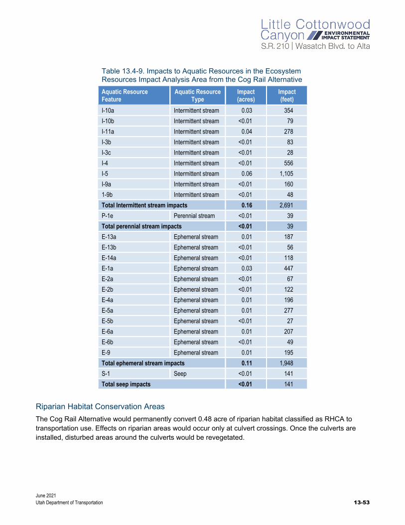
June 2021 Utah Department of Transportation 13-53
Table 13.4-9. Impacts to Aquatic Resources in the Ecosystem Resources Impact Analysis Area from the Cog Rail Alternative
Aquatic Resource Feature
Aquatic Resource Type
Impact (acres)
Impact (feet)
I-10a Intermittent stream 0.03 354
I-10b Intermittent stream <0.01 79
I-11a Intermittent stream 0.04 278
I-3b Intermittent stream <0.01 83
I-3c Intermittent stream <0.01 28
I-4 Intermittent stream <0.01 556
I-5 Intermittent stream 0.06 1,105
I-9a Intermittent stream <0.01 160
1-9b Intermittent stream <0.01 48
Total Intermittent stream impacts 0.16 2,691
P-1e Perennial stream <0.01 39
Total perennial stream impacts <0.01 39
E-13a Ephemeral stream 0.01 187
E-13b Ephemeral stream <0.01 56
E-14a Ephemeral stream <0.01 118
E-1a Ephemeral stream 0.03 447
E-2a Ephemeral stream <0.01 67
E-2b Ephemeral stream <0.01 122
E-4a Ephemeral stream 0.01 196
E-5a Ephemeral stream 0.01 277
E-5b Ephemeral stream <0.01 27
E-6a Ephemeral stream 0.01 207
E-6b Ephemeral stream <0.01 49
E-9 Ephemeral stream 0.01 195
Total ephemeral stream impacts 0.11 1,948
S-1 Seep <0.01 141
Total seep impacts <0.01 141
Riparian Habitat Conservation Areas
The Cog Rail Alternative would permanently convert 0.48 acre of riparian habitat classified as RHCA to transportation use. Effects on riparian areas would occur only at culvert crossings. Once the culverts are installed, disturbed areas around the culverts would be revegetated.

June 2021 13-54 Utah Department of Transportation
13.4.6.3 Mobility Hubs Alternative
The impacts to ecosystem resources from the mobility hubs with the Cog Rail Alternative would be the same as with Gondola Alternative B.
13.4.6.4 Avalanche Mitigation Alternatives
13.4.6.4.1 Snow Sheds with Berms Alternative
The overall ecosystem resources impacts from the Snow Sheds with Berms Alternative for the mid-canyon snow sheds would be the same as with the Enhanced Bus Service Alternative except that an additional 1 acre of developed habitat and 2 acres of shrubland habitat would be impacted by construction.
Two additional upper-canyon snow sheds would cover the cog rail alignment only, not the road. The snow sheds would be constructed during the summer. Constructing the two additional snow sheds would convert about 9 acres of mostly developed and forested habitat to transportation use. The areas where the snow sheds are proposed are regularly disturbed by avalanches and avalanche-mitigation measures, which have removed much of the vegetation along these steep slopes.
Waters of the United States
The two additional upper-canyon snow sheds would convert 0.03 acre of ephemeral stream segments E-1a and E-2b to transportation use [see Figure 13.3-2 above, Aquatic Resource Locations in the Ecosystem Resources Impact Analysis Area (1 of 2)]. However, ephemeral streams are exempt from jurisdiction as waters of the United States under the Navigable Waters Protection Rule.
Riparian Habitat Conservation Areas
The two additional upper-canyon snow sheds would permanently convert 0.13 acre of riparian habitat classified as RHCA to transportation use.
13.4.6.4.2 Show Sheds with Realigned Road Alternative
The overall ecosystem resources impacts from the Snow Sheds with Realigned Road Alternative for the mid-canyon snow sheds would be the same as with the Enhanced Bus Service Alternative except that an additional 1 acre of mostly developed habitat would be impacted by construction. The ecosystem resources impacts from the upper-canyon snow sheds would be the same as with the Snow Sheds with Berms Alternative and the Cog Rail Alternative.
13.4.6.5 Trailhead Parking Alternatives
With the Cog Rail Alternative, the Gate Buttress, Grit Mill, and Lisa Falls Trailheads would be reconstructed as part of the cog rail design. These impacts are discussed in in Section 13.4.6.2, S.R. 210 – North Little Cottonwood Road to Alta. Only the White Pine and Bridge Trailheads would be reconstructed as part of the Trailhead Improvements and No S.R. 210 Roadside Parking within ¼ Mile of Trailheads Alternative and the Trailhead Improvements and No Roadside Parking from S.R. 209/S.R. 210 Intersection to Snowbird Entry 1 Alternative.

June 2021 Utah Department of Transportation 13-55
13.4.6.5.1 Trailhead Improvements and No S.R. 210 Roadside Parking within ¼ Mile of Trailheads Alternative
The overall type of impacts to ecosystem resources from this trailhead parking alternative would be similar to those from the Enhanced Bus Service Alternative except that 3 acres of developed habitat and about 1 acre of shrubland habitat would be impacted. In addition, this alternative would impact about 0.03 acre of an intermittent stream and about 0.6 acre of riparian habitat described as an RHCA.
13.4.6.5.2 Trailhead Improvements and No Roadside Parking from S.R. 209/S.R. 210 Intersection to Snowbird Entry 1 Alternative
The impacts from this trailhead parking alternative to ecosystem resources would be the same as those from the Trailhead Improvements and No S.R. 210 Roadside Parking within ¼ Mile of Trailheads Alternative and the Cog Rail Alternative.
13.4.6.5.3 No Trailhead Improvements and No Roadside Parking from S.R. 209/S.R. 210 Intersection to Snowbird Entry 1 Alternative
The impacts from this trailhead parking alternative to ecosystem resources would be the same as with the Enhanced Bus Service Alternative.
13.4.6.6 No Winter Parking Alternative
The impacts from the No Winter Parking Alternative to ecosystem resources would be the same as with the Enhanced Bus Service Alternative

June 2021 13-56 Utah Department of Transportation
13.4.7 Mitigation Measures
13.4.7.1 Mitigation Measures for Vegetation Impacts
All of the action alternatives would remove vegetation and could also introduce noxious species into the surrounding areas. To prevent further, permanent effects, UDOT will mitigate temporary impacts to vegetation once construction is complete and no further disturbance is anticipated. Mitigation will include the following measures:
All fill materials brought onto the construction site will be required to be clean of any chemical contamination per UDOT’s General Standard Specifications, Section 02056, Embankment, Borrow, and Backfill. Topsoil for landscaping must also be free of weed seeds per UDOT’s General Standard Specifications, Section 02912, Topsoil.
Compacted soils will be ripped, stabilized, and reseeded with native seed mixes.
The contractor will be required to follow noxious weed mitigation and control measures identified in the most recent version of UDOT Special Provision Section 02924S, Invasive Weed Control.
Reseeding with native plants, followed by monitoring seedlings and invasive species until the vegetation has re-established, will mitigate direct-disturbance impacts and reduce the potential for weed invasions. UDOT will be responsible for monitoring and determining when vegetation becomes re-established.
UDOT will comply with USDA Forest Service requirements by continuing to treat noxious and other invasive weeds on areas disturbed by this project for a period of three growing seasons.
UDOT will coordinate with the USDA Forest Service to determine the proper methods for disposing of any vegetation slash generated from the Selected Alternative.
UDOT will coordinate with the USDA Forest Service and follow Salt Lake County Watershed Protection Ordinances regarding the use of any herbicides in Little Cottonwood Canyon.

June 2021 Utah Department of Transportation 13-57
13.4.7.2 Mitigation Measures for Wildlife Impacts
UDOT will implement the following mitigation measures to conserve and minimize impacts to migratory birds and in furtherance of Executive Order 13186, Responsibilities of Federal Agencies to Protect Migratory Birds:
Trees and shrubs will be removed during the non-nesting season (about August 15 to April 1). If this is not possible, UDOT or its contractor will arrange for preconstruction nesting surveys, to be conducted no more than 10 days before ground-disturbing activities, by a qualified wildlife biologist of the area that would be disturbed to determine whether active bird nests are present. If active nests are found, the construction contractor will coordinate with the UDOT Natural Resources Manager/Biologist to avoid impacts to migratory birds.
Coordination with the USDA Forest Service will be conducted to determine any known raptor nests in the helicopter flight path or in areas that could be disturbed by construction activities and to determine when and where preconstruction raptor nest surveys should occur. If active nests are found, UDOT will coordinate with the USDA Forest Service and USFWS regarding protocols to protect the active nests.
To the extent practicable, gondola towers and lighting design should consider recommendations from the Recommended Best Practices for Communication Tower Design, Siting, Construction, Operation, Maintenance, and Decommissioning (USFWS 2018). Tower lighting should be implemented only if required by FAA, and flashing red lights and an aircraft detection lighting system should be used if allowed.
13.4.7.2.1 Mitigation Measures for Aquatic Resources Impacts
UDOT must submit a preconstruction notification to USACE prior to construction if (1) the loss of waters of the United States exceeds 0.1 acre or (2) there is a discharge in a special aquatic site, including wetlands. Currently, the Enhanced Bus Service in Peak-period Shoulder Lane Alternative is the only alternative that would cause an impact to streams greater than 0.1 acre. The action alternatives would not cause any impacts to wetlands. For the impacts to the streams that require preconstruction notification, USACE may require compensatory mitigation to ensure that the activity results in no more than minimal adverse environmental effects.
If preconstruction notification is required by USACE and if compensatory mitigation is required, UDOT will prepare a mitigation plan during the Clean Water Act Section 404 permitting phase of the project. UDOT will discuss mitigation concepts with USACE and the USDA Forest Service that might include the restoration or enhancement, maintenance, and legal protection (for example, through a conservation easements) of riparian areas next to streams that would be affected.
13.4.7.2.2 Mitigation Measures for Impacts to USDA Forest Service Sensitive Species
To comply with USDA Forest Service requirements for sensitive plant species, a preconstruction survey will be completed for all alternatives in areas of ground disturbance and/or where impacts to vegetation would occur. The surveys will be completed during the growing season in 2021. The results of the surveys will be included in the Final EIS and in a separate technical memorandum to the Forest Service.

June 2021 13-58 Utah Department of Transportation
13.4.7.3 Threatened and Endangered Species Commitments
Because no federally threatened or endangered species and no critical habitat was identified in the ecosystem resources impact analysis area, no mitigation is proposed.
13.4.7.4 Mitigation Measures for Impacts to Riparian Habitation Conservation Areas
Up to about 2.5 acres of riparian habitat within the RHCAs would be converted to transportation use. In accordance with the 2003 Revised Forest Plan: Wasatch-Cache National Forest, the following Riparian Management Objectives have been developed for alternatives being analyzed by UDOT for the Little Cottonwood Canyon EIS that would be constructed within, or otherwise impact, RHCAs as defined in the Forest Plan. UDOT will implement the following mitigation measures to minimize impacts to riparian habitat:
Establish vegetation cover and stem density equal to or greater than 90% of preconstruction conditions in disturbed, nonhardened areas.
○ Use only USDA Forest Service–approved seed mixes.
○ In some areas, the USDA Forest Service may reduce re-established tree stand density requirements to improve forest health.
Structural changes to a stream channel or bed will not induce significant changes in stream velocities.
○ Removing trees outside RHCAs, in areas that are otherwise not hardened, might be subject to Riparian Management Objectives.
○ In some areas, the USDA Forest Service may reduce re-established tree stand density requirements to improve forest health.
Restore a minimum of 80% of preconstruction effective stream shading within ¼ mile of riparian canopy disturbances along streams.
Obtain USDA Forest Service approval of BMPs and a stormwater pollution prevention plan prior to submission for Utah Division of Water Quality permitting.
Follow USDA Forest Service guidelines and requirements for performing inspections of equipment and vehicles for invasive plant and noxious weed species.

June 2021 Utah Department of Transportation 13-59
13.5 References Audubon
No date How Flashing Lights on Cell Towers Can Save Birds’ Lives. https://www.audubon.org/news/how-flashing-lights-cell-towers-can-save-birds-lives. Accessed January 8, 2021.
Avian Conservation and Ecology
2013 Avian Mortalities due to Transmission Line Collision: A Review of Current Estimates and Field Methods with an Emphasis on Applications to the Canadian Electric Network.
Cornell Lab of Ornithology
No date eBird.org. https://ebird.org. Accessed November 16, 2018.
Cowardin, L.M., V. Carter, F.C. Golet, and E.T. LaRoe
1979 Classification of Wetlands and Deepwater Habitats of the United States. Office of Biological Services, U.S. Department of the Interior, FWS/OBS-79/31.
Dynamic Avalanche Consulting
2019 Little Cottonwood Canyon (S.R. 210) EIS – Snow Shed Lengths and Mitigation Memo. April 18.
HDR, Inc.
2018 Notes from a meeting with representatives from USDA Forest Service and UDOT regarding methodologies for biology and wetland analyses. May 23.
2020 Snowbird Tram Noise Monitoring. June 24.
Mersel, M.K., and R.W. Lichvar
2014 A Guide to Ordinary High Water Mark (OHWM) Delineation for Non-perennial Streams in the Western Mountains, Valleys, and Coast Region of the United State. ERDC/CRREL TR-24-13. Hanover, New Hampshire: U.S. Army Engineer Research and Development Center, Cold Regions Research and Engineering Laboratory.
NatureServe
No date NatureServe Explorer. http://explorer.natureserve.org. Accessed November 16, 2018.
Shannon, Graeme, Megan F. McKenna, Lisa M. Angeloni, Kevin R. Crooks, Kurt M. Fristrup, Emma Brown, Katy A. Warner, Misty D. Nelson, Cecilia White, Jessica Briggs, Scott McFarland, and George Wittemyer
2016 A synthesis of two decades of research documenting the effects of noise on wildlife. Biological Reviews (91): 982–1005.
[UDOT] Utah Department of Transportation
2019 Aquatic Resources Delineation Report. Prepared in support of the Little Cottonwood Canyon Environmental Impact Statement. July 2019.
2020 Noise Technical Report. Prepared in support of the Little Cottonwood Canyon Environmental Impact Statement. November 2020.
2021 Little Cottonwood Canyon Fort Union Boulevard to Alta, Pin 16092. Memorandum documenting UDOTs findings on Federally listed species, January 20.

June 2021 13-60 Utah Department of Transportation
[UDOT and Utah Division of Wildlife Resources] Utah Department of Transportation and Utah Division of Wildlife Resources
No date Utah Wildlife-Vehicle Collision Reporter. https://mapserv.utah.gov/wvc/desktop/index.php. Accessed June 7, 2019.
[USACE] United States Army Corps of Engineers
1987 Corps of Engineers Wetlands Delineation Manual. Technical Report Y-87-1. Vicksburg, Mississippi: U.S. Army Engineer Waterways Experiment Station.
2010 Regional Supplement to the Corps of Engineers Wetland Delineation Manual: Western Mountains, Valleys, and Coast (Version 2.0). ERDC/EL TR-10-3. Available online at https://usace.contentdm.oclc.org/utils/getfile/collection/p266001coll1/id/7646. Vicksburg, Mississippi: U.S. Army Engineer Research and Development Center.
2016 Aquatic Resources Excel Spreadsheet, version dated January 11, 2018, prepared by the USACE Sacramento District. Available online at http://www.spk.usace.army.mil/Missions/Regulatory/Jurisdiction/Aquatic-Resources-Delineation/. Accessed April 3, 2018.
[USDA Forest Service] United States Department of Agriculture Forest Service, Intermountain Region
No date Checklist of Albion Basin Plants. https://www.fs.fed.us/wildflowers/regions/intermountain/AlbionBasin/documents/ALBION_BASIN_PLANT_CHECKLIST.pdf.
2003 Revised Forest Plan: Wasatch-Cache National Forest. South Jordan, Utah: U.S. Department of Agriculture, Forest Service, Intermountain Region, Uinta-Wasatch-Cache National Forest. https://www.fs.usda.gov/detailfull/uwcnf/landmanagement/planning/?cid=stelprdb5076923&width=full.
[USFWS] United States Fish and Wildlife Service
2018 Recommended Best Practices for Communication Towers Design, Siting, Construction, Operation, Maintenance, and Decommissioning. April.
2020a Listed Species Believed To or Known To Occur in Utah. Available online at https://ecos.fws.gov/ecp0/reports/species-listed-by-state-report?state=UT&status=listed. Accessed November 16, 2018.
2020b List of threatened and endangered species for the Little Cottonwood Canyon Project. Species list provided by the Utah Ecological Services Field Office. July 11.
[USGS] United States Geological Survey
2016 U.S. Geological Survey Gap Analysis Program, 20160513, GAP/LANDFIRE National Terrestrial Ecosystems 2011 [data set]. https://doi.org/10.5066/F7ZS2TM0. Published May 13, 2016. Accessed June 7, 2019.
Utah Division of Wildlife Resources
No date Utah Conservation Data Center [online database]. https://dwrcdc.nr.utah.gov/ucdc/default.asp. Accessed November 16, 2018.
Utah Native Plant Society
No date Utah Rare Plant Guide. https://utahrareplants.org/rpg_species.html#All. Accessed November 16, 2018.