chapter 12 downtown - mississauga · 12-2 downtown november 2012 mississauga official plan - part 3...
TRANSCRIPT

Mississauga Official Plan - Part 3 November 2012 Downtown 12-1
12 Downtown
12.1 Introduction
The Downtown is comprised of four Character Areas:
● Downtown Core;
● Downtown Fairview;
● Downtown Cooksville; and
● Downtown Hospital.
This section identifies the modifications to the General Land Use designations in Chapter 11 that apply to the Downtown.
12.1.1 General
12.1.1.1 Proponents of development applications within the Downtown may be required to demonstrate how the new development contributes to the achievement of the residents and jobs density target and the population to employment ratio.
Map 12-1: City Structure - Downtown

12-2 Downtown November 2012 Mississauga Official Plan - Part 3
12.1.1.2 A minimum building height of three storeys is required on lands within the Downtown. Character Area policies may specify maximum building height requirements. Alternative minimum building heights may be established for existing areas with low density residential development.
12.1.1.3 Proposals for heights less than three storeys or different than established in the Character Area policies, will only be considered where it can be demonstrated to the City’s satisfaction, that:
a. an appropriate transition in heights that respects the surrounding context will be achieved;
b. the development proposal enhances the existing or planned development;
c. the City Structure hierarchy is maintained; and
d. the development proposal is consistent with the policies of this Plan.
12.1.1.4 Lands immediately adjacent to, or within the Downtown, should provide both a transition between the higher density and height of development within the Downtown and lower density and height of development in the surrounding area.
12.1.1.5 Down-zoning of lands within the Downtown and in the transition area adjacent to the Downtown should not be permitted.
12.1.1.6 Within the Downtown, on lands designated Mixed Use, Downtown Core Commercial, Convenience Commercial or Office, ground floor retail or office uses will be provided.
12.1.2 Residential
12.1.2.1 The Residential Low Density I and Residential Low Density II designations will not be permitted, except for lands designated Low Density I and Residential Low Density II at the time this Plan comes into effect.
12.1.2.2 Notwithstanding the Residential High Density policies of this Plan, the maximum building
height for lands designated Residential High Density will not exceed 25 storeys.
12.1.3 Mixed Use
12.1.3.1 Notwithstanding the Mixed Use policies of this Plan, the following additional uses will be permitted:
a. Major offices.
12.1.3.2 Mixed Use development will be pedestrian oriented and street related.
12.1.3.3 Compatible development is encouraged that recognizes the scale and enhances the form and character of Mixed Use areas.
12.1.4 Office
12.1.4.1 Notwithstanding the Office policies of this Plan, the following additional uses will be permitted:
a. Post-secondary educational facilities.
12.1.5 Motor Vehicle Commercial
12.1.5.1 The Motor Vehicle Commercial designation will not be permitted, except for lands designated Motor Vehicle Commercial at the time this Plan comes into effect.
12.1.6 Business Employment
12.1.6.1 The Business Employment designation will not be permitted.
12.1.7 Industrial
12.1.7.1 The Industrial designation will not be permitted.

Mississauga Official Plan - Part 3 November 2012 Downtown - Downtown Core 12-3
12.2 Downtown Core
Official Plan policies for lands within the Downtown Core are contained in the Downtown Core Local Area Plan.
Map 12-2: Downtown Core Character Area

12-4 Downtown - Downtown Fairview November 2012 Mississauga Official Plan - Part 3
12.3 Downtown Fairview
12.3.1 Land Use
12.3.1.1 For lands designated Residential Medium density, building height should not exceed three storeys.
12.3.2 Special Site Policies
There are sites within the Character Area that merit special attention and are subject to the following policies.
12.3.2.1 Site 1
12.3.2.1.1 The lands identified as Special Site 1 are located on the west side of Hurontario Street, south of Elm Drive.
12.3.2.1.2 Notwithstanding the provisions of the Residential High Density designation and applicable policies, the following additional policies will apply:
a. a concept plan for all or part of this site will be required and will address, among other matters, the following:
● compatibility of building form and scale with existing and proposed surrounding land uses;
● convenient pedestrian access through this site to nearby transit services on Hurontario Street;
● traffic generated will not adversely affect the transportation system;
Map 12-3: Downtown Fairview Character Area

Mississauga Official Plan - Part 3 November 2012 Downtown – Downtown Fairview 12-5
● acceptable ingress and egress, off-street parking, landscaping, and buffering; and
● preservation of mature trees and other significant natural features; and
b. Mississauga will encourage the assembly of lots fronting along Elm Drive and comprehensive redevelopment of lands in Site 1;
c. the redevelopment of lands will minimize access points to Hurontario Street to preserve the integrity of Hurontario Street as an arterial roadway. Alternative access to Elm Drive or the proposed Kariya Drive extension should be investigated as part of the comprehensive redevelopment of Site 1; and
d. apartments will be permitted at a maximum floor space index (FSI) of 2.2 - 2.9.
12.3.2.2 Site 2
12.3.2.2.1 The lands identified as Special Site 2 are located on the west side of Hurontario Street, south of Central Parkway West.
12.3.2.2.2 Notwithstanding the provisions of the Residential High Density designation and applicable policies, the following additional policies will apply:
a. the total number of units constructed on the site will not exceed 135; and
b. a maximum floor space index (FSI) of 3.75 will be permitted.
12-6 Downtown - Downtown Cooksville November 2012 Mississauga Official Plan - Part 3
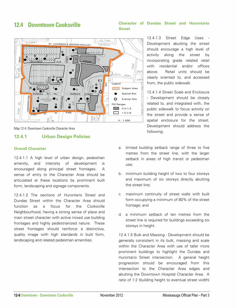
12.4 Downtown Cooksville
12.4.1 Urban Design Policies
Overall Character
12.4.1.1 A high level of urban design, pedestrian amenity, and intensity of development is encouraged along principal street frontages. A sense of entry to the Character Area should be articulated at these locations by prominent built form, landscaping and signage components.
12.4.1.2 The sections of Hurontario Street and Dundas Street within the Character Area should function as a focus for the Cooksville Neighbourhood, having a strong sense of place and main street character with active mixed use building frontages and highly pedestrianized nature. These street frontages should reinforce a distinctive, quality image with high standards in built form, landscaping and related pedestrian amenities.
Character of Dundas Street and Hurontario
Street
12.4.1.3 Street Edge Uses -Development abutting the street should encourage a high level of activity along the street by incorporating grade related retail with residential and/or offices above. Retail units should be clearly oriented to, and accessed from, the public sidewalk.
12.4.1.4 Street Scale and Enclosure - Development should be closely related to, and integrated with, the public sidewalk to focus activity on the street and provide a sense of spatial enclosure for the street. Development should address the following:
a. limited building setback range of three to five metres from the street line, with the larger setback in areas of high transit or pedestrian use;
b. minimum building height of two to four storeys and maximum of six storeys directly abutting the street line;
c. maximum continuity of street walls with built form occupying a minimum of 80% of the street frontage; and
d. a minimum setback of ten metres from the street line is required for buildings exceeding six storeys in height.
12.4.1.5 Bulk and Massing - Development should be generally consistent in its bulk, massing and scale within the Character Area with use of taller more prominent buildings to highlight the Dundas and Hurontario Street intersection. A general height progression should be encouraged from this intersection to the Character Area edges and abutting the Downtown Hospital Character Area. A ratio of 1:2 (building height to eventual street width)
Map 12-4: Downtown Cooksville Character Area

Mississauga Official Plan - Part 3 November 2012 Downtown - Downtown Cooksville 12-7
should be provided by built form abutting Dundas and Hurontario Streets.
12.4.1.6 Development Fabric - Development fronting on the Hurontario Street and Dundas Street frontages should reinforce patterns and characteristics supportive of a main street role with highly animated pedestrian spaces. Development should address the following:
a. commercial frontages should be broken up into smaller retail units and accessed directly from the public sidewalk with frequent access doorways;
b. no parking should be provided between the buildings and street line;
c. blank walls should be avoided along the street in favour of fenestration;
d. service, loading and garbage storage areas should be accessed from rear lanes or abutting side streets;
e. split level commercial frontages should be avoided;
f. periodic building indentations should be provided as relief to long building walls and to provide opportunities for pedestrian spaces;
g. storefront signage should respect the pedestrian scale and architectural character of development;
h. pedestrian weather protection should be provided in the form of canopies and/or inset arcades; and
i. the development and integration of rear yard parking lots to reduce the number of driveways along Hurontario Street and Dundas Street.
12.4.1.7 Streetscape (Open Space and Landscaping) - Development of private land abutting the sidewalk should closely coordinate with the public boulevard to create an integrated design character at the pedestrian level and to reinforce the sense of a community main street. Opportunities
for the development of entry forecourts and plazas will be encouraged in order to create a varied streetscape. Any existing vegetation will be considered for preservation through the redevelopment/infill process to enhance the liveability of a space.
12.4.1.8 Private Development Zone – Development should address the following:
a. front yard setback areas should be provided with site furnishings, landscaping and paving materials, coordinate with the public boulevard design, and extend the usability of the public sidewalk; and
b. opportunities for pedestrian spaces and circulation areas should be promoted at intersection corners, major building entrances and terminations of vistas.
12.4.1.9 Public Realm: The Design of the Public Boulevard - The following features should be encouraged to reduce the perceived visual width of the street and improve the level of pedestrian comfort, safety and convenience within the public boulevard:
a. common paving materials and patterns, street furniture and signage;
b. road crossings defined by special paving;
c. intersection design to moderate speed of turning traffic in favour of pedestrian movements, i.e. avoid the construction of designated right turn lanes with islands;
d. setting back of bus bays from intersection corners to allow sidewalks to project;
e. curb edge parking; and
f. provision of street trees, feature lighting and related pedestrian amenities.

12-8 Downtown - Downtown Cooksville November 2012 Mississauga Official Plan - Part 3
12.4.2 Transportation
12.4.2.1 All development applications are required to address the relationship with adjacent properties and the need to minimize access onto Hurontario Street and Dundas Street.
12.4.2.2 A future signalized intersection with Hurontario Street is proposed in the vicinity of the former Melissa Street right-of-way along the southerly boundary of T.L. Kennedy Secondary School. This will connect with Cook Street initially and, with the potential redevelopment of the school site, may extend to Confederation Parkway in conjunction with the possible extension of Cook Street northerly to the east GO Access Road. Redevelopment proposals in this area will consider these options.
12.4.2.3 The City of Mississauga Parking Strategy, carried out in 1993, made recommendations on the short, medium and long term strategies to meet the parking requirements and to achieve urban design objectives. These recommendations will be considered in conjunction with development applications and implementation of High Occupancy Vehicle (HOV) lanes on Hurontario Street and Dundas Street East.
12.4.3 Special Site Policies
There are sites within the Character Area that merit special attention and are subject to the following policies.
12.4.3.1 Site 1
12.4.3.1.1 The lands identified as Special Site 1, known as Cooksville Corners, are the lands surrounding the intersection of Hurontario Street and Dundas Street.
12.4.3.1.2 Notwithstanding the provisions of the Mixed Use and Utility designations, the Urban Design Policies, and other provisions of this Plan, the following additional policies will apply:
a. development up to a floor space index (FSI) of 1.0 will be permitted for street related retail, office, and community uses. Development between an floor space index (FSI) of 1.0 and 2.9 will be permitted at a ratio of 80% residential, office, community uses and overnight accommodation uses and 20% retail uses;
b. principal building entries and related forecourts are to be provided at the Dundas and Hurontario streets intersection. Dundas and Hurontario street frontages are to be developed with retail

Mississauga Official Plan - Part 3 November 2012 Downtown - Downtown Cooksville 12-9
uses having direct access to the public street and continuous weather protection by an arcade and/or projecting awnings;
c. internal pedestrian courtyards with retail/restaurant uses will be permitted subject to: the provision of integral walkways to the public street; visibility from the sidewalk; and, such courtyards being clearly secondary to street related retail uses;
d. minimum building heights of three storeys and a maximum of six storeys directly abutting Dundas and Hurontario street frontages are encouraged to create an appropriate street scale and enclosure relationship. Development exceeding six storeys to a maximum of 18 storeys will be considered subject to a minimum setback of ten metres from the building edge abutting the public sidewalk. Terracing of taller built form will be encouraged;
e. the lands located at the southeast corner of Agnes Street and Cook Street can be utilized on an interim basis for parking for the Mixed Use development to the west. When these lands are developed, they are to be in compliance with the Residential High Density designation. The majority of parking for the mixed retail and residential development shall be accommodated in a below-grade parking structure; and
f. drive-through facilities will not be permitted.
12.4.3.2 Site 2
12.4.3.2.1 The lands identified as Special Site 2 are located on the north side of Hillcrest Avenue, west of Hurontario Street.
12.4.3.2.2 Notwithstanding the provisions of the Residential High Density designation, the following
additional policies will apply:
a. office development will be permitted at a maximum Gross Floor Area (GFA) of 61 439 m2, of which a maximum of 9 290 m2 will be used for accessory uses; and
b. apartments will be permitted at a maximum floor space index (FSI) of 1.5 - 2.9.

12-10 Downtown - Downtown Cooksville November 2012 Mississauga Official Plan - Part 3
12.4.3.3 Site 3
12.4.3.3.1 The lands identified as Special Site 3 are located at the northeast corner of Agnes Street and Cook Street.
12.4.3.3.2 Notwithstanding the provisions of the Residential High Density designation, the following additional policies will apply:
a. a maximum of 121 apartment units and a maximum of 27 condominium townhouse units will be permitted on this site; and
b. the apartment building will not exceed 13 storeys in height.
12.4.3.4 Site 4
12.4.3.4.1 The lands identified as Special Site 4 are located in the southeast quadrant of the intersection of Dundas Street West and Confederation Parkway.
12.4.3.4.2 Notwithstanding the provisions of the Mixed Use designation, the following additional policies will apply:
a. a maximum of 688 apartment units; 2 541 m2 of office and retail uses; a 1 152 m2 community centre; and an eight storey, approximately 9 580 m2 existing office building will be permitted;
b. in the event that the community centre is not required, the space designated for a community centre, 1 152 m2, may be converted to office and retail uses; and
c. drive-through facilities will not be permitted.

Mississauga Official Plan - Part 3 November 2012 Downtown - Downtown Cooksville 12-11
12.4.3.5 Site 5
12.4.3.5.1 The lands identified as Special Site 5 are located on the north side of King Street West, east of Confederation Parkway.
12.4.3.5.2 Notwithstanding the provisions of the Residential Low Density II designation, offices will be permitted.
12.4.3.6 Site 6
12.4.3.6.1 The lands identified as Special Site 6 are located on the west side of Kirwin Avenue, north of Dundas Street East.
12.4.3.6.2 Notwithstanding the provisions of the Mixed Use designation, the following additional policies will apply:
a. a hotel not exceeding 42 storeys will be permitted; and
b. drive-through facilities will not be permitted.

12-12 Downtown - Downtown Cooksville November 2012 Mississauga Official Plan - Part 3
12.4.3.7 Site 7
12.4.3.7.1 The lands identified as Special Site 7 are located on the northeast corner of King Street West and Confederation Parkway.
12.4.3.7.2 Notwithstanding the provisions of the Residential Low Density II designation, offices will be permitted.
12.4.3.8 Site 8
12.4.3.8.1 The lands identified as Special Site 8 are located on the north side of Hillcrest Avenue, east of Confederation Parkway.
12.4.3.8.2 Notwithstanding the provisions of the Residential High Density designation, the lands identified as Area 8A will be permitted to develop to a maximum floor space index (FSI) of 3.5 and the lands identified as Area 8B will be permitted to develop to a maximum floor space index (FSI) of 4.0.

Mississauga Official Plan - Part 3 November 2012 Downtown - Downtown Cooksville 12-13
12.4.3.9 Site 9
12.4.3.9.1 The lands identified as Special Site 9 are located on the north and south sides of Dundas Street East and West and the east and west sides of Hurontario Street.
12.4.3.9.2 Notwithstanding the provisions of the Mixed Use designation, drive-through facilities will not be permitted.
12.4.4 Exempt Site Policies
12.4.4.1 Site 1
12.4.4.1.1 The lands identified as Exempt Site 1 are located at the northwest corner of Dundas Street East and Kirwin Avenue.
12.4.4.1.2 Notwithstanding the provisions of the Mixed Use designation, motor vehicle commercial uses will also be permitted.

12-14 Downtown - Downtown Hospital November 2012 Mississauga Official Plan - Part 3
12.5 Downtown Hospital
12.5.1 Land Use
12.5.1.1 For lands designated Residential Medium Density, building height should not exceed a maximum of four storeys unless otherwise specified in the Urban Design policies of this Plan.
12.5.2 Environmental Planning Area
12.5.2.1 The lands identified above are located generally between the North Service Road and where the Cooksville Creek crosses Camilla Road. The area subject to these policies within the Downtown Hospital Character Area, is generally located west of Cooksville Creek. The lands shown are subject to the two-zone floodplain
management concept, which divides the regulatory floodplain into two portions known as the floodway and the flood fringe. The limits of the flood fringe and the floodway are conceptual, the exact limits of which will be determined through further study.
12.5.2.2 Notwithstanding the Natural Hazards policies of this Plan, the following policies will apply to those lands within the regulatory floodplain:
a. the lands within the floodway are designated Residential High Density, Office, Greenbelt and Utility. Notwithstanding the Residential High Density, Office, Greenbelt and Utility policies of this Plan, the following uses will be permitted
Map 12-5: Downtown Hospital Character Area
Map 12-5.1: Cooksville Creek Floodplain Management Concept

Mississauga Official Plan - Part 3 November 2012 Downtown - Downtown Hospital 12-15
within the floodway subject to the satisfaction of the City and Credit Valley Conservation:
● flood and/or erosion works;
● facilities which by their nature must locate near water or traverse watercourse (i.e. bridges, storm sewer outlets and stormwater management facilities); and
● passive recreation activities; and
b. floodway lands will be zoned in an appropriate hazard category in the implementing Zoning By-law;
c. the lands within the flood fringe are subject to their respective land use designations and the following additional policies:
● development may be permitted provided the use, building or structure is flood proofed to the regulatory flood level as required by Credit Valley Conservation;
● ingress/egress for all development located in the flood fringe will be such that emergency vehicular and pedestrian movement is not prevented during times of flooding in order that safe access/evacuation is ensured. The determination of safe access shall be made by Credit Valley Conservation based on the depth and velocity factors;
● enclosed underground parking will be subject to the installation of stringent flood proofing measures to the elevation of the regulatory flood level; and
● the zoning of lands may utilize a holding zone to provide direction as to future permitted uses while ensuring flood proofing and safe access are addressed prior to development to the satisfaction of the City and Credit Valley Conservation. The Zoning By-law will be amended to remove the holding symbol when the requirements for flood proofing, the provision of safe access to the proposed development and a
detailed spill assessment and a financing agreement for the reconstruction of the culvert at the QEW has been completed to the satisfaction of the City, Credit Valley Conservation and the Ministry of Transportation; and
d. the following uses will not be allowed within the floodplain:
● institutional services such as hospitals, nursing homes, and schools where there would be a significant threat to the safety of inhabitants involved in an emergency evacuation situation as a result of flooding or failure of flood proofing measures;
● new uses associated with the manufacture, storage, disposal and/or consumption of hazardous substances or the treatment, collection and disposal of sewage, which would pose an unacceptable threat to public safety if they were to escape their normal containment/use as a result of flooding or failure of flood proofing measures; and
● emergency services such as those provided by fire, police, and ambulance stations and electrical substations, which would be impaired during a flood emergency as a result of flooding or failure of flood proofing measures.
12.5.3 Transportation
12.5.3.1 The City of Mississauga Parking Strategy, carried out in 1993, made recommendations on the short, medium and long term strategies to meet the parking requirements and to achieve urban design objectives. These recommendations will be considered in conjunction with development applications and implementation of High Occupancy Vehicle (HOV) lanes on Hurontario Street and Dundas Street East.

12-16 Downtown - Downtown Hospital November 2012 Mississauga Official Plan - Part 3
12.5.4 Special Site Policies
There are sites within the Character Area that merit special attention and are subject to the following policies.
12.5.4.1 Site 1
12.5.4.1.1 The lands identified as Special Site 1 are located on Shepard Avenue between King Street East and Paisley Boulevard East.
12.5.4.1.2 Notwithstanding the provisions of the Residential Low Density I, Residential Medium Density and Greenbelt designations, the following additional policies will apply:
a. any proposal to alter the natural alignment of the Cooksville Creek and associated Greenbelt lands through filling or channelization will require the appropriate approvals from Credit Valley Conservation and the City of Mississauga. The final design of such alteration works will address the following:
• criteria for erosion measures; and
• incorporation of the recommendations of the Cooksville Creek Rehabilitation Study for the reach of the Cooksville Creek between King Street East and Paisley Boulevard East; and
b. in the event that structural management options are not feasible and, subject to a detailed planning design and supporting engineering studies for the Special Site 1 lands, a two-zone
floodplain management concept, or combination of a two-zone floodplain
management concept and structural management options, may be implemented;
c. the limits of the development will be determined through detailed studies to address limits of flooding. Lands not suitable for development will be redesignated to Greenbelt; and
d. the preparation of a concept plan promoting the integrated redevelopment of the existing residential lots will be required in conjunction with any redevelopment applications. The concept plan will be required to address the following:
• naturalization of the Cooksville Creek and retention of existing vegetation;
• an alternate street access and design to limit access to the lands from only King Street East; and
• housing forms that provide for the stepping of densities and building heights from higher at the north and west ends of the site to lower at the south and east ends of the site.
The policies in this section and the
land use designation on Schedule 10 –
Land Use Designations with respect to
Site 1 are under appeal under OMB
Case No. PL980724 (OPA 3).

Mississauga Official Plan - Part 3 November 2012 Downtown - Downtown Hospital 12-17
12.5.4.2 Site 2
12.5.4.2.1 The lands identified as Special Site 2 are located on the south side of Paisley Boulevard, east of Hurontario Street.
12.5.4.2.2 Notwithstanding the provisions of the Residential High Density designation, apartments will be permitted at a maximum floor space index
(FSI) of 0.5 – 1.5.
12.5.4.3 Site 3
12.5.4.3.1 The lands identified as Special Site 3 are located along the west side of Hurontario Street, north of Harborn Road.
12.5.4.3.2 Notwithstanding the provisions of the Office designation, the following additional policies will apply:
a. funeral homes and nursing homes will also be permitted;
b. vehicular access and internal circulation and parking must respect both the visual and functional quality of the street as well as the privacy of the residential areas to the west;
c. efforts must be made to retain the existing vegetation cover maintaining the continuity of the area character;
d. building height and form should provide a positive scale transition between Hurontario Street and existing residential development to the west;
e. the building setback from the rear lot line should provide for the retention of natural vegetation to function as a buffer from residential uses to the west; and

12-18 Downtown - Downtown Hospital November 2012 Mississauga Official Plan - Part 3
f. the lands identified as Area A, located at 2150 Hurontario Street, will be permitted to develop at a maximum floor space index (FSI) of 1.0.
12.5.4.4 Site 4
12.5.4.4.1 The lands identified as Special Site 4 are located west of Hurontario Street, south of Queensway West.
12.5.4.4.2 Notwithstanding the provisions of the Residential Low Density II designation on these lands, the following additional policies will apply:
a. preserve and enhance the generous front, rear and side yard setbacks;
b. ensure that existing grades and drainage conditions are preserved;
c. encourage new housing to fit the scale and character of the surrounding areas, and take advantage of the features of a particular site, i.e. topography, contours, mature vegetation;
d. garages should be recessed or located behind the main face of the house. Alternatively, garages should be located in the rear of the property;
e. ensure that new development has minimal impact on its adjacent neighbours with respect to overshadowing and overlook;
f. encourage buildings to be one to two storeys in height. The design of the building should de-emphasize the height of the house and be designed as a composition of small architectural elements, i.e. projecting dormers and bay windows;
g. reduce the hard surface areas in the front yard;
h. preserve existing mature high quality trees to maintain the existing mature nature of these areas;
i. house designs which fit with the scale and character of the local area, and take advantage of the particular site are encouraged. The use of standard, repeat designs is strongly discouraged;
j. the building mass, side yards and rear yards should respect and relate to those of adjacent lots; and
k. a maximum height of three storeys will be permitted for street townhouses.