chapter 11 - water supply - potter county pennsylvania ... plan/chapter 11...chapter 11 – water...
TRANSCRIPT
Potter County Comprehensive Plan –
Preserving and Enhancing the Quality of Life for Current and Future Residents of Potter County
Chapter 11 – Water Supply
11-1
Introduction
Most people are surprised to learn that almost all of the world’s unfrozen fresh water exists under the
ground. Pennsylvania, having a humid climate, has a lot of water in streams, lakes, and wetlands. But
Pennsylvania has much more fresh groundwater than surface water - more than thirty times as much.
Groundwater contributes a large percentage of our surface flow, and in times of drought, supplies
nearly all of the flow. Wetlands often exist because of groundwater discharge. Pennsylvania’s abundant springs are groundwater discharge points. Ultimately, all Pennsylvanians rely on
groundwater for their water needs. It’s groundwater that keeps the streams and rivers flowing, and groundwater on which so many of us depend.
The importance of groundwater in Potter County is evident by the mere fact that nearly 82% of the
county’s population rely on private on-lot wells for potable water. Private on-lot wells are also
competing with the public water systems in the county since they rely upon wells and surface water resources for their supply. In general, groundwater supplies the base flow for surface creeks and
rivers, and in some instances ponds and lakes.
The comprehensive plan shall include a plan for the reliable supply of water, considering current and future water resources availability, uses and limitations, including provisions adequate to protect water
supply sources. Any such plan shall be generally consistent with the State Water Plan and any applicable water resources plans adopted by a river basin commission. The Pennsylvania Municipalities
Planning Code requires the following statements to be included in the comprehensive plan.
� Lawful activities such as extraction of minerals impact water supply sources and such activities are governed by statutes regulating mineral extraction that specify replacement and restoration
of water supplies affected by such activities.
� Commercial agriculture production impacts water supply sources.
Geologic Connection
Potter County is located in the Glaciated High Plateau and Deep Valleys Physiographic Provinces of
Pennsylvania. The Glaciated High Plateau Province generally runs along the northern region of the county. The remaining area of the county is located in the Deep Valleys Province. Within these
provinces are seven different geologic formations that affect the quality and quantity of groundwater.
These formations consist of:
� Burgoon Sandstone � Catskill Formation
� Chadakoin Formation � Huntley Mountain Formation
� Lock Haven Formation � Pottsville Formation
� Shenango Formation through Oswayo Formation, undivided
A detailed description of these formations is located in Chapter 4 of this Plan. For the purpose of
analyzing groundwater resources, this section will focus on the ground water carrying capability of each formation. This information can be found in Table 11-1.
The groundwater carrying capability and characteristics of each formation vary widely. The Chadakoin
Formation, Lock Haven Formation, and Shenango Formation have gallon per minute yields of between
1 and 10 gpm. The Cusewago Sandstone, Bedford Shale, Corry Sandstone, and Oswayo Formation have yields between 11 and 49 gallons per minute. The Huntley Mountain Formation, and Cuyahoga
Group (Meadville Shale, Sharpsville Sandstone, Orangeville Shale) have yields between 50 to 100 gallons per minute, and finally, the Burgoon Sandstone and Catskill Formation have yields in the 300
gpm range.
Map 11-1 shows the location of these yield ranges.
Table 11-1
Geologic Formations and Groundwater Characteristics
Potter County
Formation Name Median Yield Comments
Burgoon Sandstone 300 gpm
Excellent aquifer with yields greater than 300 gpm
possible; salt water and elevated iron content
encountered with increasing depth.
Catskill Formation 300 gpm
Fair to good aquifer with yields in excess of 300 gpm have
been reported, water quality is good to excellent.
Chadakoin Formation 4 gpm
Often a poor aquifer, but adequate for domestic supplies; median yield is 4 gpm; salt water and natural gas in wells
is common.
Huntley Mountain Formation 50 gpm
Average yield is 50 gpm; good quality water but high iron content is possible.
Lock Haven Formation 2 to 300 gpm
Reported yields range from 2 gpm to >300 gpm; brackish
water and hydrogen sulfide can occur.
Pottsville Formation 50 gpm
Median yield is 50 gpm; yields from sandstone and limestone may exceed 300 gpm; iron content may be
high, may encounter salt water.
Shenango Formation 5 gpm
Shales yield <5 gpm; sandstones provide good aquifer with optimum yield of 68 gpm; locally high iron is
present.
Cuyahoga Group (Meadville Shale, Sharpsville
Sandstone, Orangeville Shale) 50 gpm
Maximum median yield of 50 gpm in sandstones and siltstone of Sharpsville Formation with an optimum yield
of 115 gpm; Shales are poor aquifers with optimum yields of 75 gpm (Meadville Shale) and 15 gpm (Orangeville
Shale); locally saline water, softer water below 200-300
feet depth.
Corry Sandstone 15 gpm Good aquifer; median yield is 15 gpm.

Potter County Comprehensive Plan –
Preserving and Enhancing the Quality of Life for Current and Future Residents of Potter County
Chapter 11 – Water Supply
11-2
Formation Name Median Yield Comments
Burgoon Sandstone 300 gpm
Excellent aquifer with yields greater than 300 gpm
possible; salt water and elevated iron content encountered with increasing depth.
Catskill Formation 300 gpm
Fair to good aquifer with yields in excess of 300 gpm have
been reported, water quality is good to excellent.
Chadakoin Formation 4 gpm
Often a poor aquifer, but adequate for domestic supplies; median yield is 4 gpm; salt water and natural gas in wells
is common.
Huntley Mountain Formation 50 gpm
Average yield is 50 gpm; good quality water but high iron content is possible.
Lock Haven Formation 2 to 300 gpm
Reported yields range from 2 gpm to >300 gpm; brackish
water and hydrogen sulfide can occur.
Pottsville Formation 50 gpm
Median yield is 50 gpm; yields from sandstone and
limestone may exceed 300 gpm; iron content may be
high, may encounter salt water.
Shenango Formation 5 gpm
Shales yield <5 gpm; sandstones provide good aquifer
with optimum yield of 68 gpm; locally high iron is
present.
Cuyahoga Group (Meadville
Shale, Sharpsville
Sandstone, Orangeville Shale) 50 gpm
Maximum median yield of 50 gpm in sandstones and
siltstone of Sharpsville Formation with an optimum yield
of 115 gpm; Shales are poor aquifers with optimum yields of 75 gpm (Meadville Shale) and 15 gpm (Orangeville
Shale); locally saline water, softer water below 200-300 feet depth.
Corry Sandstone 15 gpm Good aquifer; median yield is 15 gpm.
Bedford Shale 20 gpm
Poor aquifer, maximum reported yield of 45 gpm; hard
water increased iron content are possible.
Cusewago Sandstone 20 gpm
Median yield is 20 gpm with some reported yields >100
gpm; water is soft and low in iron.
Oswayo Formation 28 gpm
Median yield is 28 gpm; salt water and hydrogen sulfide can be encountered.
Groundwater Quality
Groundwater contamination is a serious concern to many municipalities throughout Pennsylvania. In less developed municipalities where public water systems are small or nonexistent, most residents rely
on private wells to provide them with potable water. The quality of that groundwater is also a serious planning concern. Due to the malfunction of on-lot sewage disposal systems (OLDS) and intensive
agricultural operations, groundwater can become contaminated, endangering the welfare of those who drink it. When groundwater becomes unsafe to drink, remedial measures, such as the installation of
public water systems or more efficient filtration processes, must be considered.
There are many contaminants that can pollute groundwater; however, the most common contaminants
are those which result from malfunctioning OLDS or agricultural activity. These contaminants include nitrates, coliforms, and fecal streptococci.
High nitrate levels can contribute to an illness known as methemoglobinemia, which is especially
harmful to human infants and cattle and can even result in death due to oxygen starvation within the
bloodstream. To prevent this disorder, the United States Environmental Protection Agency (USEPA) has imposed a limit of 10 ppm for nitrates on drinking water. For this reason, well tests showing
nitrates over 10 ppm are considered hazardous; well tests showing results between 5 and 10 ppm may be approaching levels for concern.
The coliform group of bacteria is the principal indicator of the suitability of water for domestic, dietetic,
or other uses. The presence of any coliform bacteria renders the water potentially unsatisfactory and unsafe. The quality limit is 1 coliform colony/100 ml; remedial action is typically required when the
test indicates more than 4 coliform colonies/100 ml.
Fecal streptococci are present in the feces of warm blooded animals. Because fecal streptococci are
host specific, the ratio of fecal coliform to fecal streptococci provides more specific information about pollution sources because the fecal streptococci can be tied to a host organism. The fecal
coliform/fecal streptococci ratio provides information on possible sources of pollution as follows: ratios with findings greater than or equal to 4.4 indicate pollution derived from domestic wastes composed of
human excretion; ratios of less than .7 indicate non-human sources (animal sources); and ratios between .7 and 4.4 indicate mixed human and animal sources.
Nitrates, coliform, and fecal streptococci are the most common forms of groundwater contaminants found in Pennsylvania. However, industrial contaminants can cause groundwater supplies to become
unusable and can create a public safety issue. Unfortunately, unlike the above-referenced contaminants, industrial contamination is much more difficult to remediate and usually results in the
extension of water lines to the contaminated area for potable water.
Public Water Systems
There are a total of seven public systems operating in the county. They include Shinglehouse Borough,
Ulysses Borough, Coudersport Borough, Austin Borough, Galeton Borough, Genesee Township, and Roulette Township. The primary sources of water for these systems are deep wells or springs. System
information provided by each operator reveals all but Galeton Borough and Roulette Township have sufficient capacity to meet existing and future demands. The Roulette system is privately operated;
however, the Township is in the process of purchasing the system. Total systems capacity is 3,658,000 million gallons. Average public water usage countywide is 1,032,000 gallons per day. It was noted in
the county’s 1998 draft plan that industries requiring large amounts of water would have difficulty receiving a sufficient supply from the existing systems. In areas of proposed expansions, additional
water supply will be required.

Potter County Comprehensive Plan –
Preserving and Enhancing the Quality of Life for Current and Future Residents of Potter County
Chapter 11 – Water Supply
11-3
Detailed information on proposed improvements, management, and operating expenses can be viewed
in the Potter County Water and Wellhead Protection Plan currently being prepared. The protection plans for all of the systems in the county are still in the draft stages. Coudersport is the furthest along
in the process; only a public meeting is needed. The others are waiting for the final drafts which are being prepared by PA Rural Water.
Watersheds
The following major stream water resources are located in the County:
� Allegheny River � Oswayo Creek
� Pine Creek � Genesee River
� Kettle Creek
� Sinnemahoning Creek
The major drainage of the county occurs through three principal streams: the Genesee River, the Allegheny River, and Pine Creek. These rivers eventually flow into Lake Ontario, the Ohio River, and
the Susquehanna River.
The Genesee River drains the north central part of the county, while the Oswayo Creek drains the northwestern corner. The central section is drained to the west by the Allegheny River and to the east
by Pine Creek. Rose Lake, the only natural lake in the county, is on the divide between the Allegheny
and Genesee drainage basins. The entire southern area of the County is drained by the Sinnemahoning and Kettle Creeks, which eventually drain into the Susquehanna River.
Since the majority of the base flow is from groundwater, how these watersheds are developed will
have a direct impact on groundwater and ultimately the streams themselves. Chapter 93 of the Pennsylvania Code sets forth water quality standards for all streams and basins in Pennsylvania. The
streams in Potter County are classified as exceptional value (EV), high quality (HQ), cold water fishery (CWF) and warm water fishery (WWF).
Groundwater Management Plan for the Susquehanna River Basin
The Groundwater Management Plan for the Susquehanna River Basin was prepared by the Susquehanna River Basin Commission under the oversight of its Water Resources Management
Advisory Committee. The goal of the commission is to achieve a balanced approach for groundwater use among environmental, human, and economic needs.
The plan represents a comprehensive review of the Commission’s 1993 Plan and addresses existing and anticipated groundwater issues. Groundwater problems were assessed by reviewing issues and
impacts that have developed under existing management and the regulatory environment.
Approximately two thirds of Potter County falls within the Susquehanna River Basin. Individual
watersheds that eventually drain to the Susquehanna River include the Cowanesque River Watershed, Pine Creek Watershed, Kettle Creek Watershed, and the Sinnemahoning Watershed. These watersheds
include areas of the county that have been identified for Rural Growth, Village, and Rural Hamlet development on the future land use plan. As development occurs within these watersheds, the
Planning Commission and Conservation District must review the development activity against the
recommendations of the Plan.
A copy of the Groundwater Management Plan for the Susquehanna River Basin is on file at the Potter County Planning Commission Office for review.
Groundwater Monitoring
A USGS Observation Well is located in the Denton Hill State Park near Walton. The well is drilled to a
depth of 110’ in the Catskill Geologic Formation, has a diameter of six inches, and is cased to a depth
of 21 feet.
Groundwater and Aquifer Protection Plan
Section 301(a)(6) of the Pennsylvania Municipalities Planning Code requires a plan for the protection of aquifer recharge areas. This plan recognizes several strategies to ensure protection of aquifer recharge
areas, including wellhead protection and wetland protection overlay districts, identification of water carrying capabilities of geologic formations in the county, proper well drilling techniques, a water
conservation plan, and the efforts by the state to update the State Water Plan that would strengthen
conservation and protection practices. Several priorities as part of this initiative include: identify base water supply data so as to project critical water planning areas, create a water conservation program,
and establish water well construction standards. These strategies are explained throughout the Plan; however, the following paragraphs discuss several strategies in detail. In addition, it is important to
recognize that in implementing the groundwater and aquifer protection strategies, they must be generally consistent with the State Water Plan and any applicable water resource plan adopted by the
Susquehanna River Basin Commission.
As indicated earlier in this chapter, geology plays an important role in the quantity and quality of
groundwater. The median groundwater yields for the geologic formations in the county are two gallons per minute and 300 gallons per minute, respectively. This indicates that the majority of the county,
with the exception of those areas underlain by the Chadakoin Formation, Lock Haven Formation, and Bedford Shale, can be adequately supplied with groundwater for domestic uses.
The timing, location, and density of new development as shown in the Future Land Use Plan are
predicated on the availability of public utilities. Proposed densities outside of the growth area should have no adverse affect on groundwater supplies given normal yearly precipitation.

Potter County Comprehensive Plan –
Preserving and Enhancing the Quality of Life for Current and Future Residents of Potter County
Chapter 11 – Water Supply
11-4
Public water is supplied by seven public systems operated by two townships, one borough, and four
authorities. To ensure that their water sources are not adversely affected by new development, it is recommended that a well protection overlay district be adopted that would control the type and
intensity of development around the wells and stand pipes. By controlling the type and intensity of development around wells and reservoirs, the immediate recharge area is protected, reducing the
chance of groundwater contamination.
Pennsylvania’s Aquifers
Pennsylvania has a diverse set of rock and varied physical geography that makes generalizations about
the groundwater in the state difficult. Hydrogeologists have identified four principal types of aquifers in the state. They include sand and gravel, sandstone and shale, carbonate rock, and crystalline rock.
The sand and gravel, and sandstone and shale aquifers are two primary aquifers in Potter County. The
sand and gravel aquifer has the following characteristics:
This aquifer is located in the southeastern coastal plain along the Delaware River, along the Lake Erie
shoreline and in most major stream valleys. Those located in the Delaware estuary were deposited when the area was covered by oceans. Those in the rest of the state are glacial outwash and alluvial
deposits from the time when part of the state was covered by glaciers. Sand and gravel aquifers contain large quantities of water which can be easily withdrawn. Well yields of 1,000 gallons per
minute are common. The natural quality of the water is good to excellent.
The sandstone and shale aquifers have the following characteristics:
The aquifer is the predominant component of Pennsylvania’s bedrock, and represents the majority of
the aquifer in Potter County. In this bedrock, shales, sandstones and siltstones are inter-layered and there can be more than one waterbearing zone in a vertical sequence. Where sandstone is dominant,
the water is soft; where shales predominate, the water is hard. Yields from these aquifers are lower than that from sand and gravel aquifers with shale yielding 5-20 gallons per minute and sandstone
yielding 5060 gallons per minute. However, drilling on a fracture intersection can increase these yields substantially.
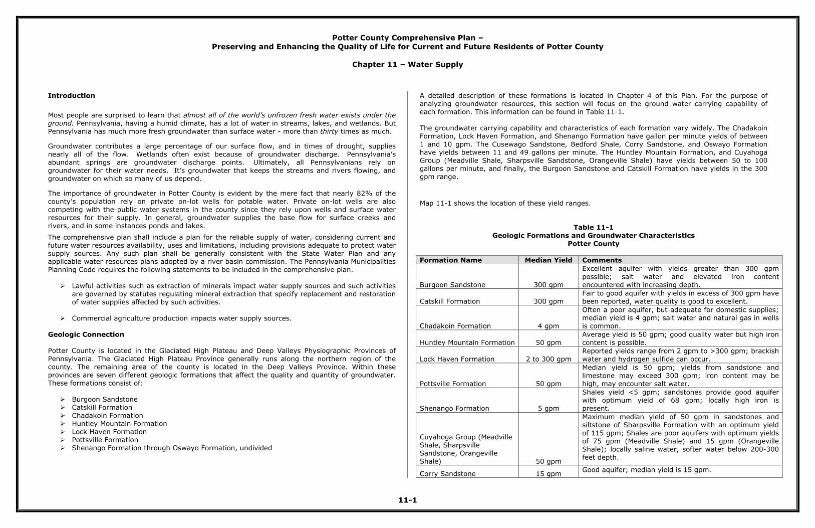
Source: Groundwater Protection and Management in Pennsylvania
Groundwater Contamination Sources and Hydrologic Cycle
Contamination of groundwater usually begins with activities on the land surface in the recharge area of an aquifer. The potential for groundwater contamination varies across Pennsylvania and depends on
the types of land activities going on in an area. Taking the state as a whole, the most significant sources of contamination are as follows:
1. Underground and aboveground storage tanks
2. Oil and gas drilling operations
3. Agriculture 4. On-lot sewage systems
5. Waste disposal sites (Including landfills for municipal and hazardous waste), storage pits, lagoons, and other surface impoundments
6. Industrial production sites, as well as smaller industrial and retail sites (such as dry cleaners and gas stations)
7. Coal mining 8. Household and garden activities
9. Abandoned oil and gas wells, as well as municipal and commercial water wells
10. Poorly constructed or deteriorated private wells 11. Deicing operations
12. Overpumping of wells
Potter County Comprehensive Plan –
Preserving and Enhancing the Quality of Life for Current and Future Residents of Potter County
Chapter 11 – Water Supply
11-5
Source: Groundwater Protection and Management in Pennsylvania
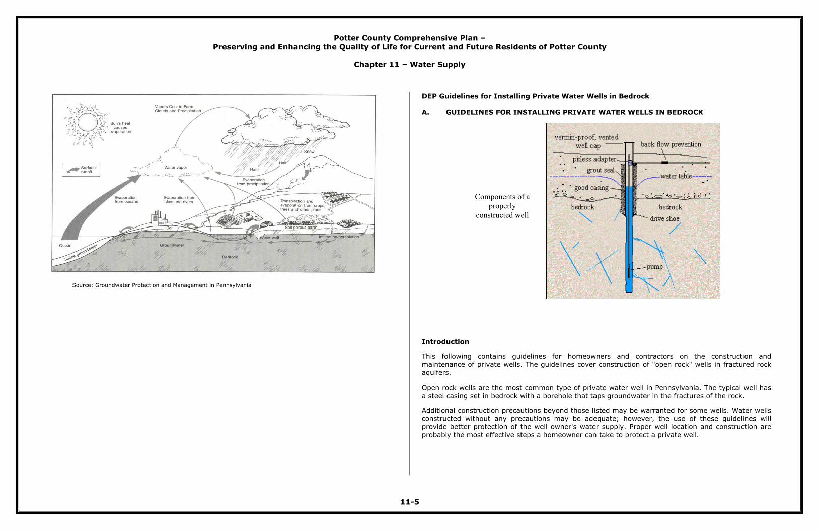
DEP Guidelines for Installing Private Water Wells in Bedrock
A. GUIDELINES FOR INSTALLING PRIVATE WATER WELLS IN BEDROCK
Components of a
properly
constructed well
Introduction
This following contains guidelines for homeowners and contractors on the construction and
maintenance of private wells. The guidelines cover construction of "open rock" wells in fractured rock aquifers.
Open rock wells are the most common type of private water well in Pennsylvania. The typical well has
a steel casing set in bedrock with a borehole that taps groundwater in the fractures of the rock.
Additional construction precautions beyond those listed may be warranted for some wells. Water wells
constructed without any precautions may be adequate; however, the use of these guidelines will provide better protection of the well owner's water supply. Proper well location and construction are
probably the most effective steps a homeowner can take to protect a private well.
Potter County Comprehensive Plan –
Preserving and Enhancing the Quality of Life for Current and Future Residents of Potter County
Chapter 11 – Water Supply
11-6
Background
Private water supplies are unregulated in Pennsylvania. Consequently, homeowners who have their
own private water supplies in Pennsylvania are not protected by any regulations or standards.
When a new well is drilled, no state requirements for construction materials, yield, or quality apply.
State law does require drillers to have a valid rig permit and a Water Well Drillers License. They must also give the State and homeowner a copy of the Water Well Completion report. This report describes
where, when, and how the well was constructed.
A few local and county governments have adopted standards for private water supplies (e.g. Chester
and Montgomery Counties.) Mortgages associated with federal housing may require certain water analyses for the well. Other lending institutions also may have sampling requirements. But for the
most part, private well owners must take responsibility for their own water quality and for maintaining their well.
Reasons for Concern
Almost half of Pennsylvanians get their water supply from groundwater. Although some areas have
inadequate amounts of groundwater, sufficient water supplies for a single family home occur just
about everywhere in Pennsylvania.
The old saying "you never miss the water 'til the well runs dry" is true. Except in severe drought, dry
wells don't happen often in Pennsylvania. What could be said more often is that "you never miss the well until you have contaminated water."
In the past, groundwater was thought to be protected from contamination by the soil layer. We now
know that is not necessarily true. Water can pass through the soil with limited filtering of contaminants
in many areas (for example, in areas with shallow bedrock, limestone with sinkholes or high water tables). In addition, poor well construction is increasingly the prime suspect in the presence of
bacterial contamination.
Coliform bacteria are a noted contaminant of concern by the U.S. Geological Survey (USGS). In a 1996 study of the Lower Susquehanna River Basin, the USGS found that "nearly 70 percent of the [146]
wells sampled had total coliform present and thus were not suitable for drinking without treatment."
The USGS concluded that poor well construction can allow contaminated surface or shallow groundwater to directly enter the well. Complicating this threat is the fact that microbial contamination
can be sporadic and often does not affect taste, appearance, or odor of the water.
A properly constructed well minimizes the threat of contamination entering the well, and keeps people
healthy who otherwise might get sick from their own well water.
What Can You Do?
As a first defense, wells should be sited at least 100 feet away from sources of contamination such as
septic system leach fields, roads, fuel tank and barnyards. Ideally, the well will be uphill from these pollution sources. Combining these isolation distance guidelines with sound construction practices will
go a long way toward protecting the groundwater quality and the user's health.
The homeowner can require the driller to construct a well that protects the water supply. This is slightly more expensive than a traditional well with no such features. However, the increased cost of
constructing a "sanitary well" may be offset by savings associated with better health of users and
protection of the water source, or by preventing the need for costly treatment equipment in the future.
Recommended Construction for Open Rock Wells
Casing – Drillers typically install a steel casing to keep the loose rock and soil from collapsing into the
well. Properly installed casing also should keep shallow groundwater and surface water from entering the well. This water is likely to be contaminated and often enters the well by flowing down the outside
of the casing. The casing should be new and meet ASTM (American Society of Testing and Materials) standards. Casing should be at least 20 feet in length and extend at least five feet into sound bedrock.
Finally, the casing should extend at least 12 inches above land surface, more if the area is subject to water accumulations that might enter the well.
Drive shoe – In most cases, a drive shoe should be used to protect the casing from cracking and
splitting during installation into bedrock.
Pitless Adapter – This device diverts water laterally below the frost line from the well to a storage tank.
It allows the well casing to extend above the ground surface. The pitless adapter should be manufactured by a reputable company and installed so that it is watertight.

Potter County Comprehensive Plan –
Preserving and Enhancing the Quality of Life for Current and Future Residents of Potter County
Chapter 11 – Water Supply
11-7
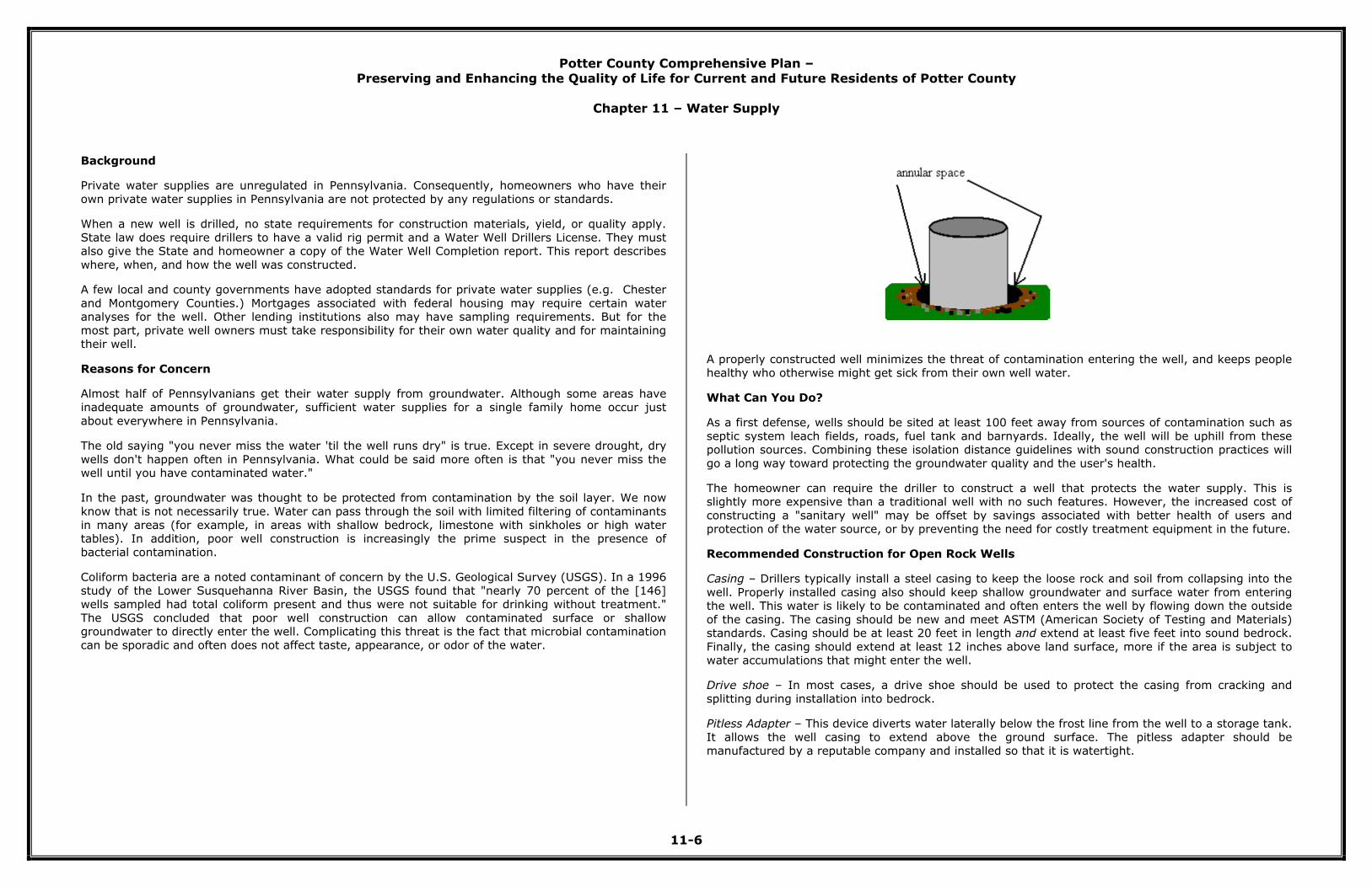
Casing Grout – When a casing is installed down a hole, an annular space is created between the wall of
the boring and the casing (see figure). If not properly sealed, the annular space becomes an avenue
for pollution to move into the water supply. To remove this threat, the annular space should be filled with a watertight sealant, such as a cement-based grout, or a grout and clay mixture. The grout
prevents contaminated surface water from seeping down along the casing directly into the groundwater. To ensure a watertight seal, the annular space should be filled from bottom to top. This
is typically done by placing a pipe in the annular space and pumping the sealant as the pipe is withdrawn. The annular space should be grouted from the casing bottom to at least the base of the
pitless adapter. For long casing lengths, the driller should grout at least 30 feet of casing to the pitless
adapter.
It is recommended that the driller construct the well in two steps. The first step is the drilling of the
hole into firm bedrock, and installing and grouting the casing. The second step would be to drill the
hole to the desired depth (after allowing the grout to cure).
There may be instances where grouting could be effectively done after completing all the drilling. In
either case, care should be given to make certain the casing seals off shallow water, and that grout is not placed into the open rock portion of the well.
Development, Yield and Disinfection
The driller should develop the well by cleaning out the fine material. The driller typically estimates the
well's yield at this time. A two- to four-person household typically requires 125-250 gallons of water
per day.
After the development, the driller should disinfect the well to kill any organisms that may be
introduced during the construction. The driller must provide a copy of the well construction record to the owner, who should keep it as a permanent record. Information on the well depth, water level (with
no pumping), well yield and the depth of the pump should be included. The well should be topped with a vermin-proof, vented cap that can be locked.
Testing the Water Quality
The water may look fine, but could have undesirable substances. Sanitary well construction is no
guarantee of safe water quality. If the aquifer is contaminated, then the construction of the well won't
help. For this reason, the water should be tested yearly for total coliform bacteria and nitrates. In addition, the well owner may want to test for additional substances.
Common undesirable substances in groundwater include coliform bacteria, nitrates, hydrogen sulfide
and excess iron, manganese, lead and turbidity. Volatile organic compounds and petroleum products
are released to the groundwater from such sources as spills and underground storage tanks. It is recommended that a DEP certified laboratory for drinking water be used for the analysis. A list of
certified laboratories can be obtained from a DEP regional office or website. An annual check on the water and the well is a good idea.
After the Well is Drilled
Well owners can take precautions to prevent problems by establishing their own "wellhead protection
areas." This involves keeping potential contaminants away from the well.
• Keep livestock or the family pet away from the well.
• Do not dispose of waste into basement or garage floor drains.
• Take used oil to a recycling center – Never dump it on the ground. Yes, the oil may have
initially come out of the ground, but it wasn't from a drinking water well.
• Mix pesticides or paints over a sidewalk or concrete pad, away from the well; apply fertilizers
and pesticides with caution.
• Be careful where you dispose of waste or where you wash equipment.
• Don't allow back-siphonage from a container or tank into a well; install a backflow preventer or
keep hoses out of mixing containers or tanks.
• Properly dispose of household chemicals and refuse. Sinkholes are probably the worst place to
put trash. Usually, a sinkhole is a direct connector to groundwater.
• Properly seal old abandoned wells.
• And remember, water drawn from a well most likely originated nearby as rainfall or snowmelt.
Good land use practices can pay off with good water quality.
References and Sources of Information
Additional information is available electronically on DEP's website at www.dep.state.pa.us directLINK
"Private Wells" or by calling the Bureau of Water Supply and Wastewater Management at 717-783-3795.
Other References:
• Bickford, T.M., Lindsey, B.D., and Beaver, M.R., 1996, Bacteriological Quality of Ground Water
Used for Household Supply, Lower Susquehanna River Basin, Pennsylvania and Maryland, USGS
Water Resources Investigations Report 96-4212. USGS (website: http://pa.water.usgs.gov/)
• Fleeger, G.M., 1998, The Geology of Pennsylvania's Groundwater, Department of Conservation
and Natural Resources, PA Topographic and Geologic Survey (website: http://www.dcnr.state.pa.us/topogeo/index.htm)
• National Well Owners Association, 601 Dempsey Rd., Westerville, OH 43081; Telephone: 800-
551-7379;
(website: http://www.wellowner.org)
• Waller, R.M., Ground Water and the Rural Homeowner, U.S. Geological Survey
Potter County Comprehensive Plan –
Preserving and Enhancing the Quality of Life for Current and Future Residents of Potter County
Chapter 11 – Water Supply
11-8
Acknowledgements
• Patrick Bowling, John Diehl, and Joe Hebelka, DEP Bureau of Watershed Management
• Chuck Eichelberger, Eichelbergers, Inc. Mechanicsburg, PA
• Gary Fleeger, Tom McElroy and Mike Moore, Department of Conservation and Natural
Resources, Bureau of Topographic and Geological Survey, Harrisburg, PA
• Beth Marshall and Edith Stevens, League of Women Voters, Harrisburg, PA
• Dennis Risser, United States Geological Survey, Water Resources Division, Lemoyne, PA
• Bill Roman, Gannett Fleming, Inc., Harrisburg, PA
Water Conservation
The DEP has developed guidelines to conserve water. In general, water consumption has ballooned
from 5 gallons of water per person per day in 1900 to an average of 50 gallons of water per person per
day. Part of this increase is due to the amenities that we enjoy and that consume water, such as automatic dishwashers and washing machines. A significant change in water usage came when the
bathroom was moved indoors.
Groundwater resources are affected every day by precipitation, population growth, economic growth
and pollution. In an attempt to alleviate supply problems, municipalities constructed new storage facilities and new sources such as wells and reservoirs.
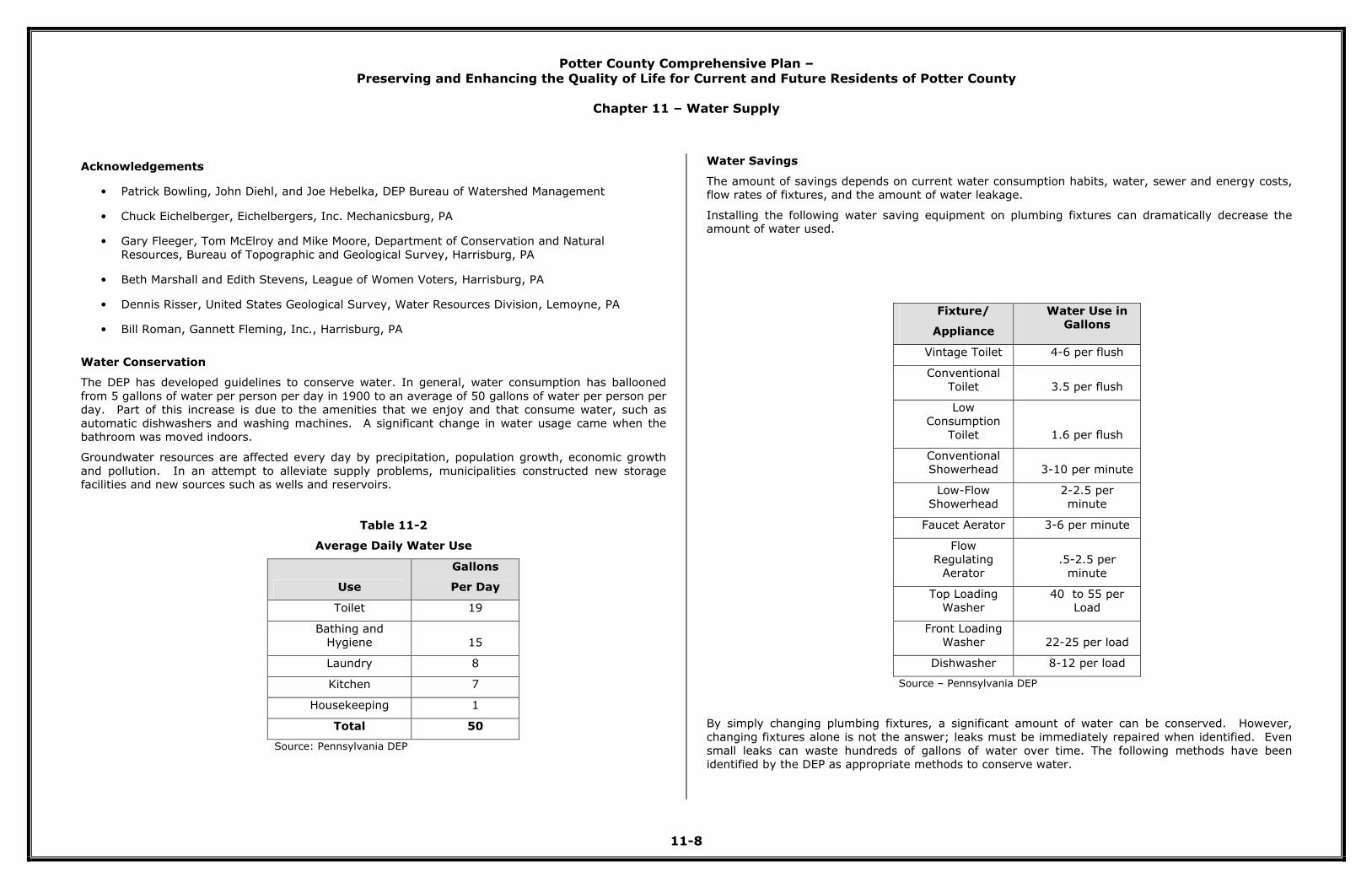
Table 11-2
Average Daily Water Use
Use
Gallons
Per Day
Toilet 19
Bathing and Hygiene 15
Laundry 8
Kitchen 7
Housekeeping 1
Total 50
Source: Pennsylvania DEP
Water Savings
The amount of savings depends on current water consumption habits, water, sewer and energy costs, flow rates of fixtures, and the amount of water leakage.
Installing the following water saving equipment on plumbing fixtures can dramatically decrease the amount of water used.
Fixture/
Appliance
Water Use in Gallons
Vintage Toilet 4-6 per flush
Conventional
Toilet 3.5 per flush
Low
Consumption
Toilet 1.6 per flush
Conventional
Showerhead 3-10 per minute
Low-Flow Showerhead
2-2.5 per minute
Faucet Aerator 3-6 per minute
Flow
Regulating Aerator
.5-2.5 per
minute
Top Loading
Washer
40 to 55 per
Load
Front Loading Washer 22-25 per load
Dishwasher 8-12 per load
Source – Pennsylvania DEP
By simply changing plumbing fixtures, a significant amount of water can be conserved. However,
changing fixtures alone is not the answer; leaks must be immediately repaired when identified. Even small leaks can waste hundreds of gallons of water over time. The following methods have been
identified by the DEP as appropriate methods to conserve water.

Potter County Comprehensive Plan –
Preserving and Enhancing the Quality of Life for Current and Future Residents of Potter County
Chapter 11 – Water Supply
11-9
In the Bathroom
• Install a low consumption toilet. • Place a weighted plastic gallon jug in the tanks of conventional toilets to displace an equal amount
of water with each flush. • Install low-flow aerators and showerheads.
• Take showers instead of tub baths. Bath young children together.
• Do not let the faucet run while brushing your teeth or shaving. • Leaking diverter valves should be replaced.
In the Kitchen and Laundry
• Refrigerate a bottle of drinking water instead of letting the faucet flow until the water is cold. • Use a dishpan or plug the sink for washing and rinsing dishes. Install a low-flow aerator on all
faucets. • Pre-rinsing dishes prior to loading in a dishwasher is unnecessary.
• Operate the washing machine and dishwasher only when they are fully loaded.
• Use the proper water level or load size selection on the washing machine.
Outside the Home
• Use a broom to clean driveways, steps and sidewalks.
• Wash the car with water from a bucket. If a hose must be used, control the flow with an automatic shut-off nozzle.
• Water the lawn during the coolest part of the day. Do not water on windy days. • Set sprinklers to water the lawn only. Do not water the street or sidewalk.
• Use soaker hoses and trickle irrigation systems to reduce the amount of water used for irrigation.
• Use mulch around landscaping.
In the Community
• Encourage the use of water conservation devices by large water using facilities.
• Survey water users within large water using facilities and develop plans to reduce water use. • Encourage a community based service organization such as a scout group to start a water
conservation program. • Encourage the use of drought tolerant vegetation in outdoor landscaping at large facilities and
community sites.
• Encourage the retrofit of older buildings with water efficient plumbing fixtures. • Direct development away from geologic formations that may contribute to the deterioration of the
aquifer. • Monitor on-lot sewage systems for malfunctions which are a major contributor to water pollution.
Water Supply Protection Strategies
The Pennsylvania Municipalities Planning Code grants authority to municipalities to regulate
development activity through the adoption of a subdivision and land development ordinance and a zoning ordinance. Water supply protection strategies can be incorporated into both regulatory
ordinances; however, since all municipalities rely on the county to review and approve subdivision and
land development plans through the Potter County Subdivision and Land Development Ordinance, protection methods are limited. This section will detail strategies that can be incorporated into the
county’s subdivision and land development ordinance, and eventually, municipal ordinances.
Subdivision and Land Development Ordinance
1. Storm Water Management
Stormwater management relates to groundwater protection because storm water that runs off roof
tops, driveways, streets, and other impervious surfaces usually goes directly into streams and rivers and therefore is not available to filter through the ground and recharge the groundwater. This leads to
a lowering of the water table, which affects the yields of wells. Storm water management becomes more complicated if the water is contaminated by petroleum products deposited on parking lots or
fertilizers spread on farmland. Contaminated runoff poses a threat to groundwater in areas of the state
with karst topography, or limestone with sinkholes.
New federal regulations enacted in December 1999 required municipalities in urbanized areas to implement a stormwater management program beginning in March 2003, and continuing for the next
five years. The regulations apply to “municipal separate storm sewer systems (MS4s),” and mandate that MS4s adopt certain local legal requirements through an ordinance, or other regulatory
mechanism, to effectuate the local stormwater management program.
The regulations require MS4s to have the following legal provisions:
• Prohibition of non-stormwater discharges (with certain exceptions)
• Requirement for erosion and sediment controls • Requirement to address post-construction runoff from new development and redevelopment,
including operations and maintenance of stormwater Best Management Practices (BMPs) • Sanctions to ensure compliance with the above provisions
The department developed a draft model ordinance and published it for public comment in the
Pennsylvania Bulletin in October 2002. The draft ordinance was based on the department’s existing
model ordinance used in the program under the Stormwater Management Act, 32 P.S. §§ 680.1 et seq. (“Act 167”), as well as various ordinances currently in use around the state.
The department issued a General Permit (“PAG-13”) for use by MS4s in meeting their permit
requirements, in December 2002. The basic requirement for MS4s is to implement a program for minimizing stormwater impacts from their system over the 5-year permit term. The permit gives
MS4s the option of using the department’s Stormwater Management Protocol—a detailed plan for implementing a stormwater management program over the five-year permit term—or developing their
own program. These same options apply to Individual Permit applicants (required in Special Protection
Watersheds).

Potter County Comprehensive Plan –
Preserving and Enhancing the Quality of Life for Current and Future Residents of Potter County
Chapter 11 – Water Supply
11-10
The Protocol contains the department’s preferred and recommended program for MS4s to address the
six required elements contained in the federal regulations:
• Public education and outreach • Public participation and involvement
• Illicit discharge detection and elimination
• Construction site runoff control • Post-construction stormwater management in new development and redevelopment
• Pollution prevention and good housekeeping for municipal operations and maintenance
The Protocol requirements also include use of the department’s model stormwater ordinance. The department will consider that aspect of the Protocol to have been met when an MS4 adopts any of the
three options contained in this guidance document. Ordinance provisions different from these model provisions can be acceptable, subject to department approval.
To satisfy the Protocol requirement to adopt the department’s model ordinance, MS4s have three options:
1. Augment an existing ordinance, or regulations, by adopting model provisions in four key
aspects 2. Adopt a complete stormwater ordinance, focusing on water quality, using the department’s
model ordinance 3. Adopt an ordinance under the Act 167 program which contains MS4-related provisions
OPTION 1: USE SELECTED MODEL PROVISIONS
There are four types of provisions which must be used and are described briefly below:
Prohibition of non-stormwater discharges: These provisions contain a basic prohibition against non-
stormwater discharges into the MS4, with certain exceptions. The exceptions include discharges under a state or federal permit, and discharges in 14 categories specified in the federal regulations.
Erosion and sediment control requirement: These provisions apply the requirements contained in
existing state regulations at 25 Pa. Code Chapters 92 and 102, including the NPDES Construction
Permit program administered by DEP and County Conservation Districts. Issuance of an NPDES Construction Permit can be used to satisfy this requirement.
Requirement to address post-construction runoff from new development and redevelopment, including
operations and maintenance of stormwater BMPs: These provisions apply the requirements contained in existing state regulations at 25 Pa. Code Chapter 93 (Water Quality Standards), and are consistent
with the NPDES Construction Permit requirements of 25 Pa. Code Chapter 92 and the Stormwater Management Planning requirements of the Stormwater Management Act, 32 P.S. § 680.1 et seq.
Issuance of an NPDES Construction Permit can be used to satisfy this requirement.
Sanctions to ensure compliance with the above provisions: The Ordinance needs to set forth sanctions
for failure to comply with the above provisions in the Ordinance.
OPTION 2: ADOPT COMPLETE MODEL STORMWATER ORDINANCE
MS4s that wish to use a complete, comprehensive stormwater ordinance can be provided a sample
ordinance that can be used to meet the MS4 permit requirements. This ordinance contains the required provisions as well as other relevant provisions commonly used by municipalities in
Pennsylvania to address water quality impacts of stormwater runoff.
This ordinance contains useful provisions to ensure long-term operations and maintenance of post-
construction Best Management Practices (BMPs), which is required by the federal regulations.
OPTION 3: Adopt Stormwater Ordinance Containing MS4-required Provisions, as Part of Approved Act 167 Watershed Plan
Many municipalities will be using the existing Act 167 process to help meet their permit requirements.
This can occur with updates of current plans, or development of new plans. This process is
administered by the Bureau of Watershed Management in the department.
Under the Act 167 planning process, counties and municipalities in watersheds around the state develop watershed-based plans to address three main aspects of stormwater impacts—flooding, water
quality and groundwater recharge. While flooding is not required to be addressed by the federal MS4 permit requirements, there are obvious benefits to addressing flooding.
The Act 167 model ordinance used in that program can be easily modified to contain MS4 provisions.
The department will work with municipalities who wish to achieve compliance with the
MS4 requirements as part of an Act 167 planning effort. Therefore, no appendix for this purpose is provided in this guidance.
2. Mandatory Dedication of Open Space
Subdivision and Land Development Ordinances may require that a development’s site plan include a
specific amount of land for parkland or recreational facilities. However, to do so the municipality must adopt a recreation plan. The land that is set aside could be part of a groundwater protection area.
3. Site Design Standards
Site design standards can help protect groundwater by controlling runoff and potentially polluting activities. Examples of standards are limitations on the amount of impervious surface allowed or on the
storage and stockpiling of potential contaminants, as well as requirements concerning landscaping.
Zoning Ordinance
1. Conditional Uses
Conditional uses are special restrictions from types of development that are added to the basic
requirements of the zoning district in which the use is located. They can be used to ensure that a wellhead or recharge area is not harmed. An example would be a requirement that gasoline stations
install double walled underground storage tanks if they are located within a wellhead protection area.
Potter County Comprehensive Plan –
Preserving and Enhancing the Quality of Life for Current and Future Residents of Potter County
Chapter 11 – Water Supply
11-11
2. Open Space Development
This zoning approach groups buildings on one or more areas on individual lots smaller than those
allowed under the base zoning requirement in order to preserve open space. The overall density of development remains same as in conventional developments. The open space area can be set aside for
groundwater protection.
3. Wellhead and Aquifer Protection Districts
Wellhead and aquifer protection districts are specially created districts around wells or above drinking
water aquifers that have more stringent protection standards than other districts in a municipality. Certain land uses may be prohibited entirely while others may be allowed only as a conditional use.
Wellhead protection areas protect the surface area around a single well or a wellfield that includes a
number of wells.
4. Overlay Zoning Districts
Overlay zoning districts are determined by overlaying a municipality’s zoning map with maps of
specific features, such as groundwater recharge or wellhead protection areas.
Potter County Water Supply Study
Source Water Protection Projects in Potter County
The project began as a concept developed during the fall of 2001. After discussing the possibility with
several of the water systems in the county, a meeting was held with the Pennsylvania Rural Water Association. At this meeting, it was decided that work loads made it impractical to prepare grant
applications for more than four of the nine Community Water Supplies in Potter County.
Consequently, separate meetings were held with Coudersport Borough, Shinglehouse Borough, Ulysses Borough and Roulette Water Company. All of these individuals agreed to solicit volunteers to form
steering committees for each or their respective systems. During this time it was decided that Charles
Cole Memorial Hospital would be included in the grant application with Coudersport Borough due to the close proximity of their water sources.
During the remainder of 2001, several meetings were held with each of the four steering committees
during which the program and the grant process was explained. All of the committees proved to be very interested in the concept of source water protection and were enthusiastic about applying for the
grants. Each committee chose a consultant/hydrogeologist based on experience with their systems. Grant applications were prepared and delivered to DEP for review. The source water protection grant
program is administered by DEP utilizing federal funding through the US EPA.
All four of the grant applications were successful, and each system received notice of the grant award
in June 2002. In addition to funding the determination of the recharge areas of each water source, the grants contained monies for public education materials, the purchase of ground water flow models,
and for the installation for road signs to identify the recharge areas along main highways.
In late 2002 and early 2003, the entire grant process was repeated for the remaining community water systems in the county. These systems included Galeton Borough, Genesee Township Water
Authority, Austin Borough, and the Northern Tier Children’s Home.
In spring of 2003, Rural Water conducted a series of training sessions at which at least one teacher
from each school district in Potter County received instruction on how to utilize the ground water flow models which were purchased with funds from the grants. The flow models will become a key tool in
each of the schools as part of an ongoing effort to educate the children of the county on the importance of groundwater protection.
Each of the second round grant applications were approved and funded by DEP in June 2003, thus
beginning the county-wide source water protection project.
Since the awarding of the final grants, all of the efforts have been focused on completing the Source
Water Protection Plans for each individual system. To date some, but not all of the plans have been completed. When finished each plan will contain the following:
1. A delineation of the recharge area for each water source. These delineations are described in
terms of one, five, ten, and twenty-year times of travel.
2. A listing of all of the known potential sources of contamination in each of the recharge areas. All of these possible contaminants were evaluated using a format developed by DEP and ranked in
order of their potential threat to the water source.
3. A revised Emergency Response Plan which defines specific actions to prevent contamination of
the water supply in the event of a spill or other contamination incident which may occur in the recharge area.
4. A list of recommendations of methods available which can be used to protect both the quality and
the quantity of the water within the recharge areas.
Pennsylvania Rural Water Association (PRWA) is responsible for completing all of the plans and
submitting them to DEP for review and approval. Some of the plans have been submitted, while others are not yet complete, however, to date none of the plans have received approval from DEP. All
of the plans should be completed and submitted for approval no later than July 1, 2005.
PRWA will continue to work on these projects until the plans are approved. The steering committees will continue to meet on an annual basis for several years to insure that the plans remain current, and
to monitor the recharge areas for any changes which might impact the sources in any way.
All of the recharge areas described in these plans have been included in a large data base developed
and used by DEP as a reference tool for the review of all environmental projects which must receive approvals or permits from the Department of Environmental Protection. When fully implemented, any
new proposal which falls in or near one of the recharge areas will be known to the reviewing agency, and the impact of the project on the recharge area will be evaluated as part of the review process.

Potter County Comprehensive Plan –
Preserving and Enhancing the Quality of Life for Current and Future Residents of Potter County
Chapter 11 – Water Supply
11-12
At this point, the jobs of the water systems, the steering committees and PRWA are completed and the
responsibility for carrying forward the source water protection program falls to the hands of local and county government officials. The county has been provided with a powerful tool which can be used to
protect a valuable natural resource for this and future generations.
There are some other counties in Pennsylvania which have done delineations for all of their community
water systems. However this is the only county where all of the community systems have done so independently with separate projects. In addition, if Potter County chooses to adopt some sort of
county-wide source water protection plan, it would be the only such plan in the Commonwealth.
Groundwater Supply Ordinance
The following water supply ordinance language can be utilized by the county or local municipalities in developing ordinances.
COMMUNITY WATER SYSTEM - Any water system meeting the definition of the term Community
Water System established by DEP other than a water system owned and operated by a governmental body, municipal authority, or a public utility regulated by the Pennsylvania Public Utility Commission.
DCNR - Pennsylvania Department of Conservation and Natural Resources
DEP - Pennsylvania Department of Environmental Protection
EPA - United States Environmental Protection Agency
PERSON - Any individual, partnership, company, association, society, corporation or other legally
recognized entity and the members of such association or partnership and the officers of such corporation.
PUBLIC WATER SYSTEM - A water supply and distribution system operated by a municipality,
municipal authority, or utility regulated by the Pennsylvania Public Utility Commission.
TRACT - All land which is the subject of a Development, whether initially or cumulatively, and
whether comprised of one or more lots of record.
Applicability
A. Each applicant proposing a Development shall submit a water service feasibility report con-cerning the availability of a public, private, or individual on-lot water system in or near the
Development, identification of the proposed water supply source, and demonstration of the adequacy of such water supply source unless exempted by this Section.
B. An applicant proposing a Development which has a projected water consumption of less than four hundred (400) gallons per day, either initially or cumulatively, as of the effective date of
this Article shall be exempt from the requirements of this Article.
Connection to Public Water System or Provision of Community Water System
A. Any Development which will create two or more residential units and any non-residential Development that proposes water consumption equal to or greater than four hundred (400)
gallons per day shall be served by public water if the Board of Supervisors determines that public water is available.
(1) If connection to an existing public water system is proposed, the applicant shall submit an agreement committing the public water provider to provide such water as the
Development will utilize for such period of time and under such terms and conditions as the public water provider provides water service elsewhere in its service area.
B. In all cases the applicant shall demonstrate that the water to be supplied shall be potable and shall meet all applicable standards of DEP or the EPA.
C. If applicant proposed to serve the Development with a community water system, the applicant shall demonstrate that the community water system shall be in compliance with all
requirements of this Article, the Subdivision Ordinance, and DEP.
Minimum Requirements for Water Supply
If the applicant proposes to serve the Development by means of a water supply system using water
obtained from the Tract (irrespective of whether that water is being distributed as a part of a community water supply system or individual wells), that water supply source may be utilized only
when the Report establishes, and the engineer performing the study to support the Report certifies, that the water supply will provide the required yield and demand, and that withdrawal rates and
amounts shall be managed to balance natural recharge rates and amounts on a site-specific basis to insure that the potential of interference with adjacent properties is minimized.
Requirements for Water Service Feasibility Report
A. An applicant shall contact the Township before beginning preparation of the Report and shall submit an application to file a water service feasibility report. Such application shall be
accompanied by the filing fee established by ordinance or resolution. The application shall at a minimum state:
(1) The professional engineer and/or professional geologist who will prepare the Report.
(2) The Tract which will be developed and the nature and extent of the proposed Development.
(3) The scope and the method of analysis of the study and testing data prior to
initiating the study necessary to prepare the Report.
B. The Township Engineer shall approve the scope and the method of analysis of the study and
testing data. The applicant shall reimburse the Township for all costs incurred by the Township Engineer in meeting with the applicant and reviewing the application.

Potter County Comprehensive Plan –
Preserving and Enhancing the Quality of Life for Current and Future Residents of Potter County
Chapter 11 – Water Supply
11-13
C. The Applicant shall present the completed Report and all supporting data to the Township
before approval of the preliminary plan or, if the Subdivision Ordinance does not require submission of a preliminary plan, with the application for approval of a final plan.
D. The Township Engineer shall review the Report to determine if it contains all information this Article requires. If the Report is incomplete, the Township Engineer shall reject the Report
and inform the applicant of the deficiencies in writing. The applicant may resubmit the Report
after addressing the Township Engineer's comments or may appeal the determination of the Township Engineer to the Board of Supervisors. The applicant shall reimburse the Township
for all costs of the Township Engineer in meeting with the applicant, analyzing the Report, and presenting information to the Township Planning Commission and Board of Supervisors.
E. The Applicant shall include the following data, presented in tabular form, for all existing wells within a one-quarter mile (1/4) miles radius of the Tract as provided by the Water Well
Inventory maintained by DCNR Bureau of Topographic and Geologic Survey as part of the Report:
(1) Pennsylvania Well Identification number
(2) Date Drilled (3) Latitude and Longitude
(4) Current street address (5) Well Dept
(6) Static Water Level (7) Well Yield
(8) Yield Measure Method (9) Length of Yield Test
F. Minimum Residential Yield/Demand Requirement. The minimum acceptable yield and demand for residential units shall be three hundred fifteen (315) gallons per day per unit of residential
occupancy at a demand rate of not less than two (2) gallons per minute for one (1) hour, either with or without the use of a storage system. The Report shall demonstrate that the
water source can supply this yield and that the water so supplied will be potable.
G. Minimum Principal Non-Residential Yield/Demand Requirement. The minimum acceptable yield and demand for non-residential units shall be four hundred (400) gallons per day per unit of
non-residential occupancy at a demand rate of not less than four (4) gallons per minute for
one (1) hour, either with or without the use of a storage system. The Report shall demonstrate that the water source can supply this yield and that the water so supplied will be
potable.
H. The Report shall contain a drawdown/well interference analysis as follows:
(1) For any Development proposing two (2) dwelling units, but less than three (3) dwelling units including remaining lands, either initially or cumulatively as of the effective date of
this Article, the Report may be prepared using available reference information and data or may be prepared by on-site testing and observation.
(2) For any Development proposing three (3) or more dwelling units, including remaining
lands, either initially or cumulatively as of the effective date of this Article, the Report shall be prepared using on-site testing and observations.
(3) A drawdown/well interference report shall be prepared for all non-residential Developments proposing water consumption of four hundred (400) gallons per day,
either initially or cumulatively, as of the effective date of this Article.
(a) For non-residential Developments proposing more than four hundred (400) gallons per day, but less than one thousand two hundred (1,200) gallons per
day, either initially or cumulatively as of the effective date of this Article, the Report may be prepared using available reference information and data, or may
be prepared by on-site testing and observation.
(b) For non-residential Developments proposing one thousand two hundred (1,200)
or more gallons per day, either initially or cumulatively as of the effective date of this Article, the Report shall be prepared using on-site testing and observations.
(c) For those Tracts for which the drawdown/well interference report was prepared
by using available reference information and data (as opposed to onsite testing and observation), and the Report indicates that the yield or demand will be
within twenty five (25 %) percent of the minimum requirements as provided above, the applicant shall be required to install the well(s) and demonstrate that
the supply is capable of meeting the yield and demand requirements prior to the application for any permits authorizing any construction upon the Tract.
(d) The on-site testing and observations as required above shall be accomplished by at least one (1) pumped well and at least two (2) observation wells which have
hydraulic continuity with the pumped well(s).
(e) The Report shall demonstrate that the groundwater recharge on the specific tract
will exceed the anticipated water withdrawal during a one (1) in ten (10) year drought or a forty (40%) percent below normal reduction in precipitation for
recharge based upon the following:
(i) The area available for recharge shall be based upon post-developed
impervious conditions.
(ii) The recharge rate may include estimated recharge from on-lot sewage
disposal systems.
(iii) The recharge rate shall include an analysis of the impact of the post -developed storm water management system.
(iv) The recharge rate may include estimated recharge from storm water
management infiltration facilities based upon a forty (40%) percent reduction in precipitation.
Potter County Comprehensive Plan –
Preserving and Enhancing the Quality of Life for Current and Future Residents of Potter County
Chapter 11 – Water Supply
11-14
(f) For residential Developments, the water withdrawal rate shall be based upon a
rate of three hundred fifteen (315) gallons per day per three (3) bedroom dwelling.
(i) The water withdrawal rate shall be increased by ninety (90) gallons per day for each additional bedroom over three (3) bedrooms.
(g) Commercial, industrial, agricultural or any other non-residential Development water withdrawal rates shall be calculated by increasing the DEP sewage flows as
provided Pennsylvania Code Title 25, Environmental Protection, Chapter 73, Standards for Sewage Disposal, Section 73.17, Sewage Flows, by twenty (20%)
percent.
(i) The Report shall include a description of the proposed use, the proposed
number of employees and whether or not water will be used for cleanup and/or processing or otherwise in connection with the use. The applicant
shall, in addition, set forth the proposed allocation of available water
supply between or among the proposed uses and shall set forth a plan or proposal pursuant to which such allocation can reasonably be monitored
and enforced by the Township.
(h) Water withdrawal rates for all other uses not provided for by the above shall be
based upon the maximum anticipated peak demand increased by twenty (20%) percent.
(i) The Report shall include a description of the proposed use, the proposed
number of employees and whether or not water will be used for cleanup
and/or processing or otherwise in connection with the use. The applicant
shall in addition set forth the proposed allocation of available water supply
between or among the proposed uses and shall set forth a plan or proposal
pursuant to which such allocation can reasonably be monitored and
enforced by the Township.
(i) The applicant shall develop a preliminary groundwater computer model to
produce a plot of the anticipated drawdown within the groundwater system to
demonstrate that the installation of the proposed water system(s) will not lower
the groundwater table in the area so as to endanger or decrease the water
supplies necessary for any existing or potential use(s) upon properties adjacent
to the proposed project.
Review of and Effect of Report
A. The applicant shall supply the Report to the Township Engineer for review to determine
compliance with this Article. The Township Engineer shall determine whether the Report contains all information and studies this Article requires and whether the Report demonstrates
that the proposed water supply for the development meets the minimum standards of this
article.
B. The Township Engineer shall provide the Township Planning Commission and the Board of Supervisors with a review of the Report.
C. The Township Planning Commission and the Board of Supervisors shall review the Report and
shall notify the Board of Supervisors whether the Development meets the minimum
requirements of this Article for a safe, adequate and reliable water supply.
Regulations for Community Water Systems installed in the Township
A. Any person who proposes the installation and use of a community water system shall demonstrate that the community water system meets the requirements of this Article for a
safe, adequate and reliable water supply. Such person shall submit an application to the
Township for a permit to operate a community water system, which shall include:
(1) A report prepared under this Article.
(2) A copy of all information supplied to DEP concerning the community water system.
(3) A copy of the DEP approval to operate the community water system.
B. The Township may annually inspect each community water system. The owner of the community water system shall pay all costs associated with the yearly inspection of the
community water system.
C. All persons who own a lot which is served by a community water system shall properly use
such community water system.The owner of the community water system shall properly
maintain the community water system.
D. Any person who owns a lot served by a community water system, any person who occupies a
lot served by a community water system, any person who owns a community water system, and any person maintaining a community water system shall report any malfunctioning or
contamination of such community water system to the Township. Such report shall be made as soon as possible but in no case later than three (3) days after discovery of the malfunction
or contamination.