chapter 11 selection of short list projects · of the colombo metropolitan region selection of...
TRANSCRIPT

Urban Transport Development Chapter 11 of the Colombo Metropolitan Region Selection of Short List Projects
Chapter 11 Selection of Short List Projects 11.1 Introduction This chapter describes the process for selecting short list projects, which is derived from a Project Long List consisting of schemes considered in past master plans and studies, together with proposals prepared by the various Working Groups. 11.2 Process for Selecting Short List Projects The process for creating a Project Short List is as shown in Figure 11.1, with each of its steps explained below.
(1) Project Long-List(Total of 197 Projects Excl. Capacity Building Projects)
Selection & Application of Criteria(By Working Group)
(2) Prioritization of Sector-Specific Projects by WG
(Short-term: 2010, Mid-term: 2015)
(4) Creation of Project Short-List by Sub-Sector
(3) Capacity Building
Projects by WG
Review of Previous Master Plans & Studies
Application of Cut-Off Line, Project Interdependency Concept
Figure 11.1 Process for Creating Project Short List (1) Project Long List As described in Chapters 2 and 10, the Study Team made an extensive review of existing master plans and studies and produced a list of 161 projects for consideration. Then, the Working Groups (see Table 1.2 in Chapter 1 for details) proposed an additional 46 projects that resulted in a final Project Long List of 209 projects (see Appendix 1), with 11 of these being capacity building projects. (2) Working Group Project Prioritization The Study Team and Working Groups identified and applied evaluation criteria to assess schemes from the Project Long List. There were common evaluation criteria used across all Working Groups, as well as sector-specific criteria to better evaluate certain projects. For each criterion, marking was divided into three categories: High (3 points), Medium (2 points) and Low (1 point). The common evaluation criteria and the sector-specific criteria are outlined in the tables below. Note that this exercise excluded the assessment of capacity building projects, as their impacts are inherently difficult to quantify. Results of scoring by each working group are summarized in Appendix 33.
11-1

Urban Transport Development Chapter 11 of the Colombo Metropolitan Region Selection of Short List Projects
Table 11.1 Common Evaluation Criteria for Project Prioritization Used by All Working Groups
Criteria Description Technical Feasibility (Positive Criteria): Is this project technically possible within the
timeframe indicated? Impact on Reducing Congestion (Positive Criteria): How much will this project assist in reducing
traffic congestion in the CMR? Impact on Promoting Public Transport
(Positive Criteria): How much will this project assist in developing public transport and increasing ridership?
Institutional Barriers (Negative Criteria): How high are the institutional risks associated with this project, including lack of regulations, difficult trade unions, lack of strategic framework, managerial capacity, contradictory regulations/laws, etc.
Social Impacts (Negative Criteria): What level of social impacts would this project produce, including resettlement, land acquisition, unemployment?
Environmental Impacts (Negative Criteria): What level of environmental impacts would this project produce, including increases in air, noise, and water pollution?
Source: This Study
Table 11.2 Additional Sector-Specific Evaluation Criteria for Project Prioritization
Working Group Criteria Description
Improvement of Network Connectivity
(Positive Criteria): How well does this project connect to other links in the network?
Road Development Planning Consistency with Urban
Development Plans (Positive Criteria): How consistent is this project with previous urban development plans?
Level of Cooperation Regarding Rationalization
(Positive Criteria): Is there likely to be much cooperation from the stakeholders with regards to the project?
Public Transport
Lack of Policy Consistency (Negative Criteria): Has the policies involved in the project changed repeatedly in the past 10 years?
Traffic Management and Safety:
Impact on Enhancing Traffic Safety
(Positive Criteria): How much will this project enhance traffic safety?
Source: This Study Applying the above criteria, schemes from the Project Long List, which were divided into short-term projects (i.e., completion possible by 2010) and mid-term projects (i.e., completion possible by 2015) taking into account various constraints such as project maturity, land acquisition problems, etc., were given a numerical score and sub-sector project prioritization carried out. (3) Capacity Building Projects In addition to the above, the Working Groups also identified 11 capacity building projects (see Table 11.3), with five of these being for public transport, three for road development planning, three for traffic management & safety, and one for environmental purposes. The capacity building projects, which cost relatively little, were prepared with the objective of remedying basic sub-sector capacity shortcomings and are therefore important for facilitating the high priority projects to be recommended in Chapter 17. For this reason, these projects are to be implemented with the high priority projects and no further screening is considered necessary (see Appendix 21 for details). In fact, the Study Team recommends that these projects be implemented at the earliest date possible once funding is available.
11-2

Urban Transport Development Chapter 11 of the Colombo Metropolitan Region Selection of Short List Projects
Table 11.3 List of Capacity Building Projects
Project Implementation Agency Public Transport 1. Bus-3: Strengthening of NTC on Transport Planning and
Operations/Management NTC
2. Bus-4: Strengthening of SLTB on Operations/ Management SLTB 3. Bus-5: Develop a Training Center at WPRPTA and Undertake
Strengthening of WPRPTA, Private Bus Owners/Operators, and Crew
WPRPTA
4. Rail-3: Strengthening of SLR on Management and Operations and Development of a Strategic Business Unit to Implement Pilot Projects
SLR
5. 3W-1: Strengthen the WPRPTA to Implement and Strengthen the Three-Wheeler Services Bureau and Outline Three-Wheeler Regulations
WPRPTA
Road Development 6. Road-48: Capacity Building of CMC - Drainage Maintenance CMC 7. Road-54: Capacity Building of RDA – Land Acquisition &
Resettlement RDA
8. Road-55: Capacity Building of RDA – Road Design Standards and Maintenance Coordination
RDA
Traffic Management& Safety 9. TM-17: Capacity Building of CMC and RDA - Traffic
Management & Safety CMC, RDA
10. TM-19: Capacity Building of Traffic Police Traffic Police Social and Natural Environment Working Group: 11. Env-1: Cross-Sector Capacity Building - For Personnel and
Equipment for Vehicle Inspection, Roadside Inspection, Emission Inspection, & Monitoring
CMT, Police, RDA, CPC, CEA
(4) Derivation of Project Short List The Study Team applied two approaches to develop a comprehensive short list of projects that could possibly be implemented during the time period established for this Study (i.e., by 2015). First, based on the results of the Working Groups’ evaluation applying the above-mentioned criteria in (2) a cut-off line was identified, with those projects scoring high with regards to positive criteria and low to negative criteria being short-listed. Second, those projects that did not make the first cut-off, but had a high interdependency with projects above the cut-off line were also added to the short list. Note that this methodology meant that projects with significant social and environmental impacts were screened out unless sufficient mitigation measures could be implemented. 11.3 Short-Listed Projects Applying the process described in the preceding section, it is possible to derive a Project Short List by sub-sector, which consists of a total of 35 schemes, as shown in Table 11.4. The Study Team believes that all 35 short-listed projects can be finished by 2015. Note that the seven shaded projects indicate soft or non-infrastructure schemes. The remaining 28 short-listed projects will be considered for further screening in Chapter 17 in order to derive high priority infrastructure projects for pre-FS level analysis. These are mapped in Figure 11.2. These projects, together with the other short-listed projects, are described in detail in Chapters 12 to 16.
11-3
Urban Transport Development Chapter 11 of the Colombo Metropolitan Region Selection of Short List Projects
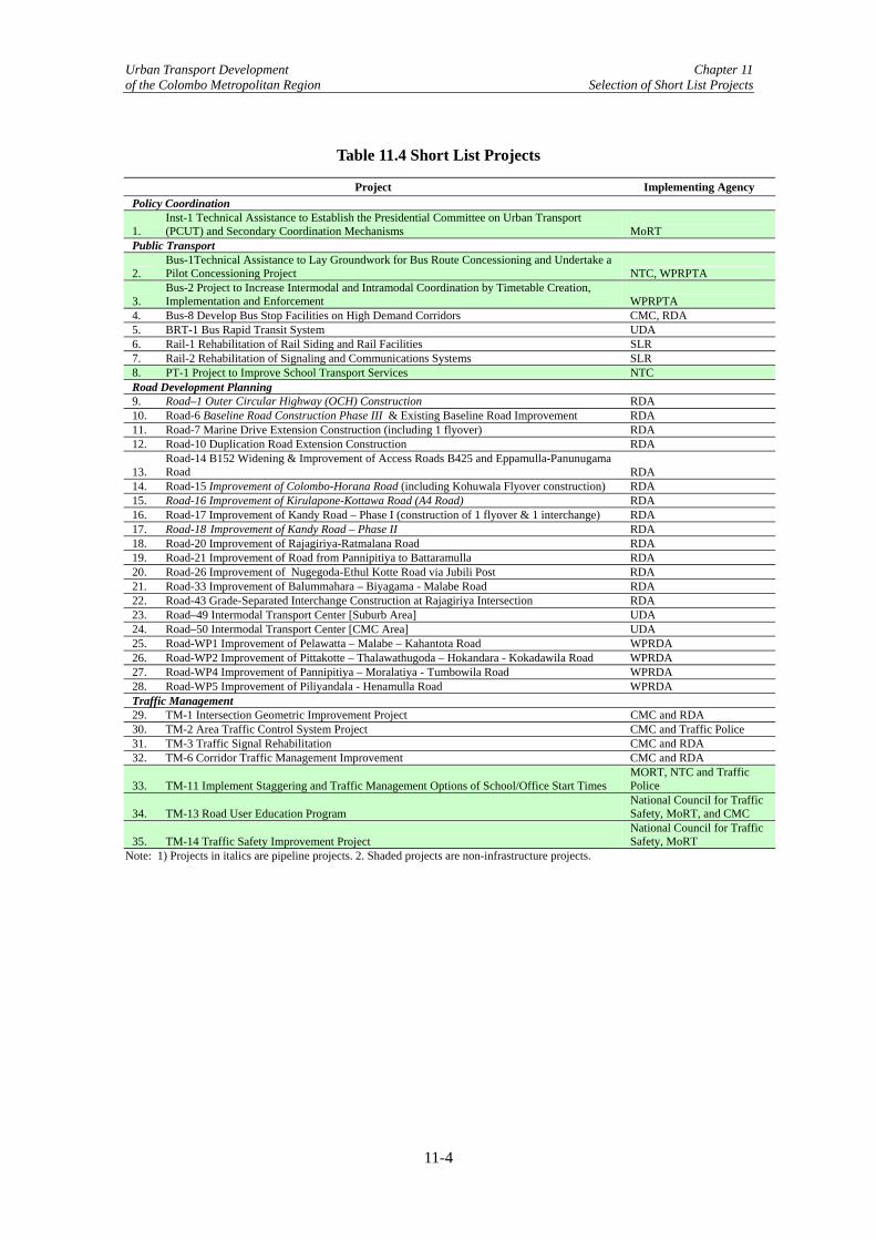
Table 11.4 Short List Projects
Project Implementing Agency Policy Coordination
1. Inst-1 Technical Assistance to Establish the Presidential Committee on Urban Transport (PCUT) and Secondary Coordination Mechanisms MoRT
Public Transport
2. Bus-1Technical Assistance to Lay Groundwork for Bus Route Concessioning and Undertake a Pilot Concessioning Project NTC, WPRPTA
3. Bus-2 Project to Increase Intermodal and Intramodal Coordination by Timetable Creation, Implementation and Enforcement WPRPTA
4. Bus-8 Develop Bus Stop Facilities on High Demand Corridors CMC, RDA 5. BRT-1 Bus Rapid Transit System UDA 6. Rail-1 Rehabilitation of Rail Siding and Rail Facilities SLR 7. Rail-2 Rehabilitation of Signaling and Communications Systems SLR 8. PT-1 Project to Improve School Transport Services NTC Road Development Planning 9. Road–1 Outer Circular Highway (OCH) Construction RDA 10. Road-6 Baseline Road Construction Phase III & Existing Baseline Road Improvement RDA 11. Road-7 Marine Drive Extension Construction (including 1 flyover) RDA 12. Road-10 Duplication Road Extension Construction RDA
13. Road-14 B152 Widening & Improvement of Access Roads B425 and Eppamulla-Panunugama Road RDA
14. Road-15 Improvement of Colombo-Horana Road (including Kohuwala Flyover construction) RDA 15. Road-16 Improvement of Kirulapone-Kottawa Road (A4 Road) RDA 16. Road-17 Improvement of Kandy Road – Phase I (construction of 1 flyover & 1 interchange) RDA 17. Road-18 Improvement of Kandy Road – Phase II RDA 18. Road-20 Improvement of Rajagiriya-Ratmalana Road RDA 19. Road-21 Improvement of Road from Pannipitiya to Battaramulla RDA 20. Road-26 Improvement of Nugegoda-Ethul Kotte Road via Jubili Post RDA 21. Road-33 Improvement of Balummahara – Biyagama - Malabe Road RDA 22. Road-43 Grade-Separated Interchange Construction at Rajagiriya Intersection RDA 23. Road–49 Intermodal Transport Center [Suburb Area] UDA 24. Road–50 Intermodal Transport Center [CMC Area] UDA 25. Road-WP1 Improvement of Pelawatta – Malabe – Kahantota Road WPRDA 26. Road-WP2 Improvement of Pittakotte – Thalawathugoda – Hokandara - Kokadawila Road WPRDA 27. Road-WP4 Improvement of Pannipitiya – Moralatiya - Tumbowila Road WPRDA 28. Road-WP5 Improvement of Piliyandala - Henamulla Road WPRDA Traffic Management 29. TM-1 Intersection Geometric Improvement Project CMC and RDA 30. TM-2 Area Traffic Control System Project CMC and Traffic Police 31. TM-3 Traffic Signal Rehabilitation CMC and RDA 32. TM-6 Corridor Traffic Management Improvement CMC and RDA
33. TM-11 Implement Staggering and Traffic Management Options of School/Office Start Times MORT, NTC and Traffic Police
34. TM-13 Road User Education Program National Council for Traffic Safety, MoRT, and CMC
35. TM-14 Traffic Safety Improvement Project National Council for Traffic Safety, MoRT
Note: 1) Projects in italics are pipeline projects. 2. Shaded projects are non-infrastructure projects.
11-4

Urban Transport Development Chapter 11 of the Colombo Metropolitan Region Selection of Short List Projects
Figure 11.2 Location of Short-Listed Infrastructure Projects
11-5

Urban Transport Development Chapter 11 of the Colombo Metropolitan Region Selection of Short List Projects
11-6

Urban Transport Development Chapter 12 of the Colombo Metropolitan Region Road Construction and Improvement Projects
Chapter 12 Road Construction and Improvement Projects 12.1 Introduction The purpose of this chapter is to provide a summary of each of the short-listed projects selected by the Road Development Planning Working Group (RDPWG) as explained in Chapter 11. This, together with the project sheets in Appendices 20, 21, and 33, serve as a reference for the further screening of these projects, which will result in the selection of High Priority Projects that will be screened for possible consideration for pre-feasibility study analysis. Figure 12.1 shows components of short-listed projects.
Road Construction & Improvement Project
Infrastructure Project
Capacity DevelopmentProject
New Road Construction
Road Improvement
Drainage MaintenanceLand AcquisitionRoad design & Maintenance Coordination
Outer Circular HighwayBaseline RoadMarine DriveDuplication RoadNorthern & Northeastern CorridorsEastern CorridorsSouthern & Southeastern CorridorsFeeder Roads (B&C Class)
Infrastructure Project
Figure 12.1 Component of Road Construction and Improvement Projects 12.2 New Road Construction Road-1 Outer Circular Highway (OCH) Construction Construction of the 29.1 km long OCH will divert through traffic from Colombo and increase network connectivity via the linking of major transport corridors. Completion of construction of the section from A4 to Kelani River is expected by 2012. Project Description
The OCH will be an orbital highway located approximately 15-20km from the center of Colombo and is to be an accessed-controlled four-lane1 grade-separated structure, which was originally to link seven major arterials in Colombo. Due to revisions in the scope of the Southern Highway and the OCH projects, the OCH project will link five of these major arterials and the Southern Highway project two of them. The construction of the OCH will result in a continuous expressway extending from the International Airport to the southern part of the country through connections with both the Colombo-Katunayake Expressway and the Southern Highway. After several revisions regarding its intended components, the present OCH is to be implemented as three contract packages and their present status are as follows:
1 The OCH is to be a 6-lane road facility after 2020.
12-1

Urban Transport Development Chapter 12 of the Colombo Metropolitan Region Road Construction and Improvement Projects
Package 1 : CKE to Colombo-Kandy Road [AA 001]-[9.1km]-Basic Design Completed
Package 2 : Colombo-Kandy Road [AA 001] to Colombo-Hanwella Low Level Road [AB 010]-[7.9km]-Basic Design Completed
Package 3 : Colombo-Hanwella Low Level Road [AB 010] to Colombo-Ratnapura-Wellawaya-Batticaloa Road [AA 004]-[12.1km]-Detailed Design Completed
Benefits
The OCH will serve the important role of both an urban road facility that will improve network hierarchy and connectivity between the growth centers in Colombo suburbs and as a road that will promote greater access between different regions of the country. Its construction will reduce travel times and vehicle operating costs substantially via the realization of a more rational road network, and its construction is vital in terms of alleviating congestion in the long term, as it will also promote growth in areas outside of the congested city center. Risk Mitigation Measures
As land acquisition and compensation are vital to the smooth and timely implementation of the OCH project, the Study Team has proposed a capacity building scheme to improve the functioning of the land acquisition and resettlement division of RDA to minimize delays (see section 12.4 (Road-54) for details). Packages 2 and 3 are scheduled for completion by 2013 and 2012, respectively. Package 1 should be completed by 2015, but resettlement is an especially difficult issue on this section, while some minor resettlement issues remain regarding Package 2. Finally, another matter requiring risk management is the handling of the problem of soft soil, as this could have an adverse impact on construction costs. Road-6 Baseline Road Construction Phase III and Existing Baseline Road Improvement Baseline Road construction will consist of its extending and/or widening (inclusive of bridge/culvert construction) from High Level Road at Kirulapone to Ratmalana on Galle Road (7.42km). Note that the improvement of the existing Baseline Road consists of building an interchange at Orugodawatta and a flyover that would cross over the intersections between Borella-Buddahalaoka.
Project Description
The Baseline Road is a very important piece of infrastructure, and Phase I and II of this road have already been successfully completed, which currently ends at High Level Road. However, completing the last and final Phase III is vital to alleviate traffic on the highly congested Galle Road. Phase III would start from High Level Road at Kirulapone and terminate at Ratmalana on Galle Road for a total distance of 7.42km. The right of way is 30m and runs through both wetlands and hilly areas and, therefore, much structural work is expected. In addition to this extension work, which would form an inner ring road that would complement the OCH, this project would also include the construction of an interchange at Orugodawatta located at the north end of Baseline Road and a flyover that would extend from Bauddhaloka Junction to Borella Junction that would pass over three congested intersections on the same road. This is considered necessary as these intersections are already congested and will become more so when Phase III is finished. Moreover, it is the opinion of the Study Team that the interchange
12-2

Urban Transport Development Chapter 12 of the Colombo Metropolitan Region Road Construction and Improvement Projects
and flyover should be considered for Baseline Road as there is both short-distance and long-distance traffic. The flyover and interchange would handle the latter and alleviate congestion overall. Benefits
The Baseline Road extension and improvement will address issues on unclear road hierarchy, limited access in Suburban Colombo and network weaknesses. It also diverts traffic coming into the Colombo Municipal Council (CMC) area and alleviates congestion on major corridors inside the CMC. It will reduce travel times and vehicle operating costs substantially, and accessibility to social services (hospitals, schools and administrative functions) located on Baseline Road will be improved. Risk Mitigation Measures
Social impacts are expected to be moderate with the implementation of Phase III, and more than half of affected residents have already been relocated. As for the flyover and interchange construction, social impacts are also anticipated to be moderate and the management of traffic during construction would be necessary. Note that Chapter 24 will provide deeper consideration for environmental impacts mitigation near densely populated areas due to the transportation of construction materials. It is expected that the project will require 5 to 5.5 years to complete. Road-7 Marine Drive Extension Construction (including 1 flyover) Extension of Marine Drive (2km to the north and 1.75km to the south) will alleviate congestion on Galle Road by providing a viable alternative route along the coastline. In addition, a flyover will be built at Dehiwala to provide better access to Marine Drive from Galle Road. Project Description
A project to extend Marine Drive also has the objective of reducing traffic on Galle Road. Presently, traffic conditions on Marine Drive are poor, which is understood to be caused by two factors: (1) access from Galle Road to Marine Drive is poor and (2) the current length of Marine Drive is insufficient to attract trips of sufficient distance. An outline of the project is indicated below.
• Marine Drive will be extended to both the north and south. • To the north, the road is to be extended from Bambalapitiya to Kollupitiya for a distance
of about 2km. Note that the trace is established and the detailed design is available from RDA.
• To the south, the road is to be extended from Ramakrishna Road to Dehiwala for a distance of about 1.75km. The road survey work has been completed for this section and the detailed design is in progress and will be available from the RDA.
• Construction of a flyover at flyover at Dehiwala on Galle Road. Benefits
The construction of the Marine Drive extension will help to improve issues of unclear road hierarchy, limited access in Suburban Colombo and network weaknesses. It also would attract a larger number of trips from Galle Road and alleviate congestion on that important arterial road. As for the upgrading of Ramakhrishna Road (350m) and the construction of the flyover at
12-3

Urban Transport Development Chapter 12 of the Colombo Metropolitan Region Road Construction and Improvement Projects
Dehiwala, these works would improve the connectivity of Marine Drive with Galle Road and promote the greater use of the former. The impact of the Marine Drive extension, together with alleviating congestion on Galle Road, will also provide more space for commercial activities in Kollupitiya and Dehiwala and therefore stimulate the local economy. Anticipated Risks
Construction of the Marine Drive extension and flyover at Dehiwala will have moderate social impacts. The project will require about four years and these impacts, including land acquisition, should be properly handled to ensure the project is completed within this time frame. Note that transport facilities at Kollupitiya and Bambalapitiya should be improved to handle intermodal traffic to realize the full potential of Marine Drive. Road-10 Duplication Road Extension Construction The extension of Duplication Road by 450m to connect directly with the four-lane W.A. Silva Mawatha Road will create a better alternative route to Galle Road, and thereby reduce congestion and promote commercial growth on the southern portion of Duplication Road. Project Description
Duplication Road begins at Slave Island and ends at Dharmarama Road intersection near the Wellawatte Canal for a distance of about 5km. From there, traffic either accesses Galle Road via the sub-standard two-lane Dharmarama Road or the narrow Peterson Lane and four-lane W.A. Silva Mawatha Road. The Duplication Road extension, which is only 450m in length, would connect directly with the four-lane W.A. Silva Mawatha. Benefits
The Duplication Road extension improves issues of unclear road hierarchy, network weaknesses and weaknesses of urban road concept. It also would greatly improve access between Galle and Duplication Road. This extension, in addition to alleviating traffic on Galle Road, will make Duplication Road more accessible and stimulate commercial development on its southern end. With the completion of the extension, it may also be possible to reconsider one-way operation for Duplication and Galle Road. Anticipated Risks
As for project implementation, opposition from local residents and a nearby school is expected. As a result, it is anticipated that this project (including land acquisition) would require three years to complete. An awareness program for affected persons regarding the project is important in order to realize its completion.
12-4

Urban Transport Development Chapter 12 of the Colombo Metropolitan Region Road Construction and Improvement Projects
Kollupitiya
Bamballapitiya
Wellawatta
Dehiwala
Fort
Ratmalana
Mar
ine
Driv
e
A2 G
alle
Roa
d
Dup
licat
ion
Roa
dD
uplic
atio
n R
oad
Flyover or Geometric improvement should be applied to Dehiwala intersection to maintain free flow. (Road-7)
2.0km Extension between Kollupitiya and Bamballapitiyaincluding access road widening(Road-7)
1.8 km Extension between Wellawatta and Dehiwaraincluding access road widening (Road-7)
450 meter extension to W.A. Silva Mawatha (Road-10)
Galle road carries more than 80,000 pcu per day, and serves for 19 bus routes.
Existing 4 km doesn’t function due to lack of accessibility and lack of travel time reducing.The extended Marine drive can work as bypass for long trip and alleviate congestion on Galle Road
Duplication road carries more than 30,000 vehicle per day. It can be work as a bypass of Galle Road.
Proposed Construction
Existing Road
Figure 12.2 Proposed Improvements for Road-7 and Road-10 12.3 Road Improvement There are a total of fourteen short-listed road improvement projects. These are described below in clockwise order in terms of their location on existing corridors. (1) Northern and Northeastern Corridors Road-14 B152 Widening and Improvement of Access Roads B425 and Eppamulla-Panunugama Road The widening of B152 to a standard two-lane road for a distance of 5.2 km, together with the upgrading of access roads B425 and the Eppamulla-Panunugama Road to a standard two-lane structure, will provide an alternative route to A3 and thereby reduce congestion. Project Description
The originally proposed improvement of B152 by RDA, which was to consist mainly of widening and overlay work, was originally intended to cover a distance of 35km and to be an alternative route between Colombo and Negombo via the Mattakkuliya Bridge. However, the Study Team revised the scope since little benefit is expected from the upgrading of the northern approach to Negombo. Consequently, improvement is to extend from
12-5

Urban Transport Development Chapter 12 of the Colombo Metropolitan Region Road Construction and Improvement Projects
Mattakkuliya Bridge along B152 to Uswetakeyyawa-Bopitiya Road for 5.2km, from Uswetakeyyawa-Bopitiya Road (which is being improved by ADB) to the B425 Junction along the Eppamulla-Panunugama Road for 2.82km, and then along the entirety of B425 to A3 for 5.7 km, for a total distance of about 13.7km. This work will consist of an overlay and the widening of the existing substandard two-lane road facility to a standard two-lane road facility. Benefits
Upgrading B152 will improve issues of unclear road hierarchy, limited accessibility and network weaknesses. Note that it will increase the connectivity of the coastal industrialized area of Gampaha District with Colombo Port, and also provide an alternative route for local traffic accessing Colombo from coastal Gampaha and thereby reduce the amount of traffic crossing the Friendship Bridge. As for the improvement of B425 and the Eppamulla-Panunugama Road, this is done in order to provide access between A3 and the future CKE to B152.
ColomboPort
Industrial zone
Mattakuliya
Jaela
Mahabege
CKE
A3 N
egom
bo R
oad
Nawaloka
Hendella
Negombo road still serve more than 50,000 per day.
Energy storage site, dumping site, food industry, fishing industry, etc locate in this area.
WPRDA has started improvement of this section by assistance of ADB
5.7km widening of B425 connect B152, CKE, and A3 Rd. This road can work as a collector to Negombo road.
RDA has finished land acquisition for southern access road to Mattakuliya Bridge. Opening of this section will attract traffic
A3 N
egom
bo R
oad
Existing access road has been saturated with present traffic.
Proposed Widening
Existing Road
Pipelined Widening
Pipelined Construction
Eppamulla-Panunugama Road (2.82 km)
B152 widening (5.2km)
Figure 12.3 Proposed Improvements for Road-14
12-6

Urban Transport Development Chapter 12 of the Colombo Metropolitan Region Road Construction and Improvement Projects
Anticipated Risks
There are engineering and archaeological issues that need to be considered at Hamilton Canal. Road-17 Improvement of Kandy Road–Phase I (construction of 1 flyover and 1 interchange) Construction of a flyover at Kelaniya Rail Crossing and an interchange at Panchikawatte on Kandy Road will eliminate two serious bottlenecks and substantially reduce delay times. Project Description
Together with A2 and A3, Kandy Road is one of the most important corridors in Colombo. Project Road-17 proposes that two improvement components be carried out for this vital corridor. The first component is the construction of a flyover at the Kelaniya Railway Crossing on the SLR Main Line, where large numbers of trains pass during the peak hour (about 20 for both directions). The second component is to build an interchange at Panchikawatte that connects two major business centers (i.e., Fort and Maradana).
The PRC has agreed to donate to 4 lane widening for 2.2km
OCH
OCH will open in 2012
The 4.78 km section, connecting Imblugoda to Kadawatha, still left as two lane. ADB will design and resettlement work for 4 lane improvement. (Road-18)
Rail traffic crosses the main corridor with 58,000 pcu per day. Flyover with 4 lanes road can improve the situation. (Road-17)
Traffic from Port came across to A1 at the Panchikawatte junction. This study propose flyover or geometric improvement (Road-17)
Fort
Kelaniya
Kadawatha
Imbulgoda
This section has been already widen for 4 lanes. It serves for 10 routes of WP bus transport and other inter city bus traffic.
To Kotte
To Gampaha
ADB will do D/D and Resettlement to Nittambuwa
Proper four lane Improvement connecting Imbulgodato Kotte is proposed (Road-33)
Proposed Widening
Existing Road
Pipelined Widening
Pipelined ConstructionBorella
A1 Road
A1 Road
Figure 12.4 Proposed Improvements for Road-17 and Road-18 Benefits
The two improvement components will complement the widening of the Kiribathgoda to Kadawatha Road from two to four lanes, which is to be carried out by the Chinese Government, and will eliminate bottlenecks adversely affecting traffic on this section of Kandy Road. It is expected that the elimination of these bottlenecks will result in substantial time savings. It will also improve road hierarchy and network weaknesses along Kandy Road.
12-7

Urban Transport Development Chapter 12 of the Colombo Metropolitan Region Road Construction and Improvement Projects
Anticipated Risks
Project impacts will be moderate but proper management of traffic flows during construction is necessary. For the Kelaniya Railway Crossing especially, a proper detour road must be prepared. Project completion, including land acquisition, is estimated to require five years. Road-18 Improvement of Kandy Road-Phase II Improvement, which is expected to be carried out by ADB, is to consist of widening to four lanes a 4.78km road section north of Kadawatha and will provide greater capacity and thereby reduce congestion. Project Description
Kandy Road is one of the most important corridors in Colombo. Project Road-18 proposes is to consist of the widening of the Kadawatha to Imbulgoda section (4.78 km) on the Kandy Road to 4 lanes and is expected to be carried out by ADB. Benefits
The upgrading of the Kadawatha-Imbulgoda section, which will be carried out by ADB, will reduce congestion and travel time on this busy section of Kandy Road and would be implemented after Project Road-17. Note that Imbulgoda Junction connects the road to Gampaha town, which is the capital of Gampaha District and has the important role of providing social and administrative services. This project will improve road hierarchy and network weaknesses along Kandy Road. Anticipated Risks
The construction impacts of this project package are moderate but, as in the case of Project Road-17, careful traffic management is necessary during construction in order not to worsen the already bad traffic congestion. Completion of the project is estimated to require three years. (2) Eastern Corridors Road-43 Grade-Separated Interchange Construction at Rajagiriya Intersection The construction of this interchange will result in the efficient channeling of multi-directional traffic and thereby result in the reduction of delays on the important Parliament Road. Project Description
The intersection at Rajagiriya on Kollupitiya-Sri Jayawardenepura Road is one of the most congested intersections in CMR, with 80,000 vehicles per day passing in an east-west direction. The intersection has five approaches and north-south traffic flows are also heavy, and it is located on the road to Parliament. An interchange with enough ramps to provide access in all directions has been proposed; however, this decision should be finalized based on an analysis of directional traffic movements. A concept paper has been prepared and submitted to JICA, but no analysis has been included. Geographical information for Road-43 is shown in Figure 12.6.
12-8
Urban Transport Development Chapter 12 of the Colombo Metropolitan Region Road Construction and Improvement Projects
Benefits
With the construction of an interchange at Rajagiriya Intersection, traffic would be efficiently channeled and would result in significant reductions in delay times and congestion. It also improves road hierarchy in the Eastern corridor. Anticipated Risks
There are several risks regarding implementation and they are as follows:
• The Chinese Government has commenced work on the signalization of this intersection. However, RDA envisages grade separation as being the most suitable long-term solution.
• The intersection is located in a relatively low-lying area and construction and operation costs may increase due to countermeasures for soft soil and drainage.
• Since this intersection is located on the road to Parliament and the country’s national administrative complex, appropriate landscaping work will be required.
(3) Southern and Southeastern Corridors
Road-16 Improvement of Kirulapone-Kottawa Road (A4 Road) The improvement of this road will consist of widening the section from Kirulapone to the Southern Highway to 4 lanes and the section thereafter to Godagama to a standard two-lane road facility. This work will complement the completion of the Southern Highway and serve as an important access route that will also stimulate economic development. Note, however, that land acquisition is required for the entire road length of 19.9km. Project Description
This Study proposes to improve A4, a main corridor for southeastern direction, from Kirulapone Bridge to the Southern Highway Interchange to four lanes and thereafter to two lanes to Godagama. This major arterial road will serve a number of developed city centers and the road corridor is developing both commercially and residentially. ADB has assured the availability of funds for land acquisition and resettlement and hopes to sign a contract in June 2006 Benefits
Population density and car ownership in the areas along the southeastern corridor are higher than in any other area. The above improvement will accommodate future traffic growth on this corridor and will serve a number of important growth centers and will be a nexus for both commercial and residential development. Risk Mitigation Measures
Detailed design studies have been executed by ADB and a land acquisition and resettlement program has commenced based on this. There is a possibility of ADB funding this widening and the Chinese Government has pledged to carry out the construction of a flyover at Nugegoda Junction (see Figure 12.5). Any work on A4 should take this into account and the necessary coordination that needs to be carried out. It is recommended that widening work for A4, which will extend from High Level Road to Godagama, be completed before the opening of the first section of the Southern Highway in September 2009. However, based on Study Team estimates,
12-9

Urban Transport Development Chapter 12 of the Colombo Metropolitan Region Road Construction and Improvement Projects
it seems that the quickest that widening could be completed will be the end of 2011, or 2 years after the first section of the Southern Highway is finished. This could result in serious congestion problems on A4 in the interim and utmost efforts must be made to speed up land acquisition. Road-15 Improvement of Colombo-Horana Road (including Kohuwala Flyover construction) This road improvement will consist of widening the 15km section from Pamankada Bridge to Kahathuduwa to a 4-lane road facility and widening the 12.6km section from Kahathuduwa to Horana to a standard two-lane road facility for a total of 27.6km. Note that this is to be done in parallel with the upgrading of A4 and will serve as an important access route to the Southern Highway. Construction of a flyover at Kohuwara is also proposed as part of this improvement. Project Description
The project road begins at Pamankada Bridge and ends at Horana for a distance of 27.6km, consisting of a four-lane 15km section to Kahathuduwa Interchange and a 12.6 km section to Horana. Presently, this road is a two-lane structure that passes through developed areas near a city center and underdeveloped areas at the ends. Under this project scope, a flyover is to be constructed at Kohuwala Junction in order to ensure sufficient capacity for future traffic flows. Benefits
With the above improvement, the Colombo-Horana Road will be able to handle the increase in traffic flows from the Southern Highway that will stimulate economic growth and fulfill its role as an important access road for the Southern Highway. Anticipated Risks
Like High Level Road, land acquisition on this corridor is lagging behind schedule and it seems unlikely that widening can be completed before the end of 2011, meaning that this corridor could also face extremely serious congestion problems upon the completion of the Southern Highway in September 2009. Strenuous efforts should therefore be made to expedite land acquisition work.
12-10

Urban Transport Development Chapter 12 of the Colombo Metropolitan Region Road Construction and Improvement Projects
Kohuwala
Kahathuduwa
Maharagama
Kottawa
Nugegoda
GodagamaPolgasowita
PolgasowitaWP Road
Baseline Extension
STDP
Church St,
Killurapone
Baseline Road
The 4 lane widening for 11.8 km section has been proposed. ADB is reviewing D/D. (Road-16)
OCH
The 4 lane widening for 15 km section has been proposed. ADB is reviewing D/D. (Road-15)
The 2 lane widening for 12.6 km section has been proposed by ADB. (Road-15)
The 2 lane widening for 8.1 km section has been proposed by ADB. (Road-16)
Flyover or Geometric improvement should be applied to Kohuawaraintersection (Road-15)
STDP will open September 2009.
Feeder road; refer– WP4
Hor
ana
Roa
d
A4 R
oad
Feeder road; refer Road-26
Proposed Widening
Existing Road
Pipelined Widening
Pipelined Construction
The PRC has agreed to donate Flyover at Nugegoda
Figure 12.5 Proposed Improvements for Road-15 and Road-16 (4) Feeder Roads (Class B Roads) Four important Class B feeder roads (i.e., Rajagiriya-Ratmalana Road, Pannipitiya-Battaramulla Road, Nugegoda-Kotte Road, and Balummahara-Biyagama-Malabe Road) that link up with Class A roads were short-listed. A description about each is given below and a location map shown in Figure 12.6 is given afterwards. Road-20 Improvement of Rajagiriya-Ratmalana Road The improvement of this road, which consists of widening either to a standard 4-lane or standard two-lane road facility, will increase accessibility between the three important arterials of Horana Road, A4, and Parliament Road. This road after its improvement could become an attractive alternative to Baseline Road. Project Description
The first feeder road project runs from Rajagiriya to Ratmalana, beginning at Welikada Plaza at Rajagiriya Junction and passing through Koswatee Junction, Open University at Nawala, and connecting to Stanley Tillakaratne Mawatha Road at Nugegoda. It is proposed that this section of road be improved to a standard four-lane road facility with a 1.2m rumble strip divider whenever possible and, when this is not possible, to a standard two-lane road. The improvement work for this road project is as follows:
12-11

Urban Transport Development Chapter 12 of the Colombo Metropolitan Region Road Construction and Improvement Projects
• Rajagiriya to Nugegoda Intersection (4.9km): Standard four-lane divided road with bus bays, parking facilities, and side drains.
• Bridge Improvement at Open University. • Nugegoda Intersection to Katiya Handiya along Old Kesbewa Road (0.8km): Standard
two-lane road with a 1.5m cycle lane on either side. • Katiya Handiya to High Level Road (Gamsaba Junction) along Subaddrama Road
(0.5km): Standard two-lane road with a 1.5m cycle lane on either side. • Gamsaba Junction to Bridge location along Dehiwala Road (0.8km): Standard two lane
road with a 1.5m cycle lane on either side. • Bridge Improvement at Udyana Mawatha.
There is a possibility to obtain Japanese Bank for International Cooperation (JBIC) Small Scale Infrastructure Rehabilitation and Upgrading Project (SIRUP) funding for (i) bridge improvement at Open University and (ii) the last three portions from Katiya Handiya to the bridge at Udyana Mawatha. Benefits
Upgrading this road will improve accessibility between Horana Road, A4, and Parliament Road, and provide better access for local traffic to the numerous facilities on these important corridors. The development of a pedestrian facility along the corridor will improve pedestrian and non-motorized traffic as well as accessibility of public transport. Anticipated Risks
Some resettlement is required and an awareness campaign may be necessary. Note, however, that the Study Team proposes that the southern 2.1km portion be upgraded to a standard two-lane facility as it will be difficult to install a 4-lane road in this residential area. Traffic will also need to be managed during construction, especially at the intersections with major corridors. Road-21 Improvement of Road from Pannipitiya to Battaramulla The improvement of this 7.5km road will consist of widening the existing road to be a 4-lane road facility, which will increase accessibility between A4 and Parliament Road. Project Description
The second Class B feeder road project will improve parts of an existing trace that connects High Level Road with the administrative capital of Sri Lanka, which is about 7.5km long. Note that road widening and surface improvement has been completed from Pelawatte to Thalawatugoda Junction (2.0km). The road sections to be improved under the project are about 5.5km in length and cover residential areas. An outline of the project work is given below.
• Battaramulla to Palawatte: (2.0km): to be improved to a 4-lane road. • Palawatte to Thalawatugoda: (2.0km): already improved to a 4-lane road. • Thalawatugoda to Pannipitiya (3.5km): Section with varying terrain and sub-grade soil
conditions and is to be improved to a 4-lane road with a center median of 1.2m • There will be a 2.4m sidewalk and a 1.0m side drain on either side.
12-12
Urban Transport Development Chapter 12 of the Colombo Metropolitan Region Road Construction and Improvement Projects
Benefits
This project will improve accessibility in a growing suburban area between two of the most important arterial roads in Colombo (A4 and A0) and provide better access for local traffic. The development of a pedestrian facility along the corridor will improve pedestrian and non-motorized traffic as well as accessibility of public transport. Anticipated Risks
Regarding implementation, there will be some minor disturbances to traffic flows during construction and appropriate measures for soft ground may be necessary on some sections. Surface drainage will also need to be improved as part of this project’s scope. Road-26 Improvement of Nugegoda – Ethul Kotte Road via Jubili Post Improvement, which covers a distance of 5.95km, consists of widening the existing road to a 4-lane facility and will increase accessibility between the 3 important arterials of Horana Road, A4, and Parliament Road. After improvement is completed, this road could be an attractive to Baseline Road. Project Description
The third Class B feeder road, like Road-20, also connects Horana Road, A4, and A0 and is therefore also an important link. It is proposed that this two-lane road, which extends from Nugegoda to Kotte via Jubilee Post, be widened to four lanes. Redefining cross-sections with lane markings and vehicle segregation will also be incorporated. Benefits
This project will improve access between Parliament Road (A0) and the important commercial center of Nugegoda and thereby stimulate development. This section runs along the commercial area, therefore, the accessibility improvement for pedestrians will make impact to the economic vitality of the area. Anticipated Risks
It has been reported that there is some difficulty regarding land acquisition on the northern portion of this road. Therefore, early awareness programs and compensation packages should be drafted and implemented. The proposed road also runs through a hilly area, so vertical curve alignment improvement should be considered in the design stage. Drainage improvement should be examined for the northern section of the road. Note that engineering and environmental considerations for widening will be undertaken in the pre-feasibility study phase.
12-13

Urban Transport Development Chapter 12 of the Colombo Metropolitan Region Road Construction and Improvement Projects
Baseline
Nugegoda Growth Center
Nugegoda Growth Center
BattaramullaGrowth Center
Borella Growth Center
Sequent 2.1km section on Old Kesbewa, SubaddramaRoad, and Dehiwala Road should be improved to proper 2 lane road (Road-20)
Bas
elin
e
A4
Horana Road
Kotte Road
This section has been improved by SIRUP
Kotte road serves over 80,000 vehicle per day.
Collector Road between Battaramulla and Nugegoda should be widen to 4 lane. (Road-26)
Collector Road between Rajagiriya and Nugegoda should be widen to 4 lane. (Road-20)
Flyover or Geometric improvement should be applied to Dehiwalaintersection to maintain free flow. (Road-43)
Kirullapone
Narahenpita
Proposed Widening
Existing Road
Pipelined Construction
Proposed Widening
Existing Road
Pipelined Construction
Figure 12.6 Proposed Improvements for Road-20, Road-26 and Road-43 Road-33 Improvement of Balummahara-Biyagama-Malabe Road This improvement work, which covers a distance of approx. 25km, will consist of widening the existing road to a 4-lane road facility, and could serve as an alternative to Kandy Road; thereby, reducing congestion on this busy corridor. Project Description
The fourth and last Class B feeder road is an existing two-lane road from Balummahara to Malabe via Mudungoda and Biyagama, and connects Kandy Road to Kotte Road. It is proposed that this road be widened to a four-lane structure and that the redefining of cross-sections with lane markings and vehicle segregation also be incorporated. Note that the design work for most
12-14

Urban Transport Development Chapter 12 of the Colombo Metropolitan Region Road Construction and Improvement Projects
of the road sections has been completed under different road projects. It is anticipated that the improvement of this road will reduce traffic on both Kandy Road and Low Level Road. Benefits
The improvement of this route could provide an important alternative to Kandy Road and thereby reduce congestion on that busy corridor. Anticipated Risks
In terms of the project’s social impacts, these are expected to be moderate. Environmental impacts can be mitigated with appropriate countermeasures. (5) Feeder Roads (Class C Roads) Road-WP1 Improvement of Pelawatta-Malabe-Kahantota Road Road-WP2 Improvement of Pittakotte-Thalawathugoda-Hokandara-Kokadawila Road Road-WP4 Improvement of Pannipitiya-Moralatiya-Tumbowila Road Road-WP5 Improvement of Piliyandala-Henamulla Road Improvement of these important Class C feeder roads would increase access for local traffic to services and facilities on important arterial roads. Project Description
Class C roads come under the purview of the WPRDA, and of the road sections that they proposed for improvement four were selected to be shortlist projects (i.e., WP1, WP2, WP4, and WP5). WP1 and WP2 extend into the Kotte hinterland and serve as important feeder roads in this growing area. The total length of WP1 is 7.0km and that of WP2 is 8.4km. As for WP4, this connects the important arterial roads of A4 and Horana Road and serves local trips. WP5 also connects two important roads (i.e., Galle and Horana Road). The implementation of this project to improve Class C feeder roads would consist of widening the existing 5m carriageway to the standard 7.0m width. Redefining cross-sections with lane markings will also be incorporated. Benefits
The upgrading of these roads is important to improve the level of service for feeder transport such as local buses and three wheelers, which in turn would improve accessibility for residents living in these areas. Those four sections will provide cross-cutting routes between Galle, A4, Horana, and Parliament Roads, which will ease the issue of network weaknesses in developing southeastern area. Anticipated Risks
Land acquisition is expected to be minimal. As for project implementation, WPRDA would be the responsible body and has experience doing this under SIRUP, and should therefore be capable of coordinating detailed design work and construction. 12.4 Capacity Development Three capacity development projects were proposed by the RDPWG and a summary of their contents is provided below.
12-15

Urban Transport Development Chapter 12 of the Colombo Metropolitan Region Road Construction and Improvement Projects
Road-48 Capacity Development for CMC Drainage and Road Maintenance In order to improve fatal weaknesses of the urban road network during the rainy season, a project for drainage management improvement in CMC was designed. The main portion of this project is to provide equipment, however, technical assistance for maintenance improvement are also included. Project Description
Intersections in Colombo are easily closed in rainy season due to overflows of stormwater, which make Colombo road network paralyzed through peak hours. The main reasons for storm water overflows are a lack of maintenance and insufficient drainage capacity. Secondary factors include an increase in paved area and the lack of a master plan. Also, in order to improve the capacity for road maintenance, a set of maintenance equipment will be delivered. This project aims to improve CMC’s capacity for drainage maintenance and road maintenance in order to minimize storm water overflows. The project will be composed by following three activities;
• Implementation and Evaluation: Provision of equipment to improve the efficiency of routine and urgent maintenance. The experts will also monitor and evaluate the execution of these action programs. Over 80 % of investment will be provided to this portion.
• Study and Planning: Dispatch of international experts to conduct a comprehensive study on a capacity development program for drainage maintenance.
• Master Plan Preparation: The experts will prepare terms of reference for a drainage master plan and coordinate its initial implementation.
Benefit
It will reduce travel time and traffic conflictions in Colombo area. Anticipated Risks
UDA also manages storm water; therefore, it is necessary to coordinate between the activities of UDA and CMC. Road-54 Capacity Development for Land Acquisition and Resettlement With the increase in infrastructure improvement to deal with the growing size and complicated nature of Colombo, there has been a corresponding increase in the need for land acquisition as well. For this reason, the methods, skills, and equipment necessary to do this effectively will be provided, as long delays in land acquisition can derail a project. Project Description
One major difficulty in road development is the lack of capacity for land acquisition. The legislative system has been improved as described in Chapter 7; however, the recent increase of land acquisition demand due to increases in ADB funding for infrastructure projects exceeds capacity of the authorities concerned. Additionally, the compensation program has become complicated. It is usual to take 4 to 5 years to complete land acquisition and resettlement.
12-16

Urban Transport Development Chapter 12 of the Colombo Metropolitan Region Road Construction and Improvement Projects
The Study Team proposes a capacity development program in order to stimulate all projects under this study. The main portion of this capacity development is equipment provision; however, the following activities should also be implemented to enhance the equipment provision.
• Promotion of effective land acquisition: Land acquisition methodologies will be considered from both a domestic and international context via study tours, teleconferences, and seminars.
• Process improvement: The awareness program contents should be improved under supervision of the experts.
• Evaluation: The experts will evaluate the awareness program and its improved process. Since this study proposes projects in developed areas, the process is even longer. The study team proposes to provide equipment for daily use and a training program for the improvement of the land acquisition process. The project includes sending several experts to an awareness development program as well as budget for training. Benefit
This project will accelerate resettlement activities, and mitigate risk of land acquisition of projects which have been proposed under this study. Anticipated Risks
There are no risks anticipated for this project implementation. Road-55 Capacity Development for Road Design and Maintenance Coordination The purpose of this project is to develop urban road design and maintenance standards to minimize maintenance coordination with RDA and utility operators. Coordination meetings will be facilitated through assistance of experts and develop methodologies for road maintenance. This project will also provide a budget for a small scale project implementation to apply the new standard prepared under this project. Project Description
In Sri Lanka, there is no standard for urban roads so the standard for intercity roads has been applied. Therefore, important functions for urban streets (vehicle-pedestrian separation, pedestrian traffic flow, space for street furniture, etc.) are not considered and planned for sufficiently, resulting in such phenomena as pedestrian facilities having insufficient capacity, poor accessibility to public transport, inadequate urban landscaping, a lack of barrier-free facilities, and poor coordination between utility location and street design. The proposed project plans to set up a coordination body comprising road administrators, utility companies, etc. in CMR to help promote more efficient road maintenance and will include the assistance of international experts. The project will also contain a study tour to other countries, studies on technical coordination applicable to CMR, and pilot project implementation for maintenance work. This project will be divided into three stages;
• Needs Assessment: A needs assessment will be conducted in order to determine the required design standards for urban roads and coordination between road maintenance bodies, utility companies, etc. via a participatory approach.
12-17
Urban Transport Development Chapter 12 of the Colombo Metropolitan Region Road Construction and Improvement Projects
• Preparation of Measures: A study to be implemented with the assistance of local consultants on urban road design and road maintenance/utility coordination will be carried out and include study tours.
• Pilot Project: A pilot project implementing the new urban road design and road utility coordination method will be executed.
Benefit
This project will increase capacity of pedestrian footpaths, reduce the conflict between pedestrians and vehicles, and consequently contribute to the reduction of traffic jams in the urban area. Also, it will assist in developing the urban aesthetics of Colombo. Anticipated Risks
There are no risks anticipated for this project implementation.
12-18
Urban Transport Development Chapter 13 of the Colombo Metropolitan Region Traffic Management and Safety Improvement Projects
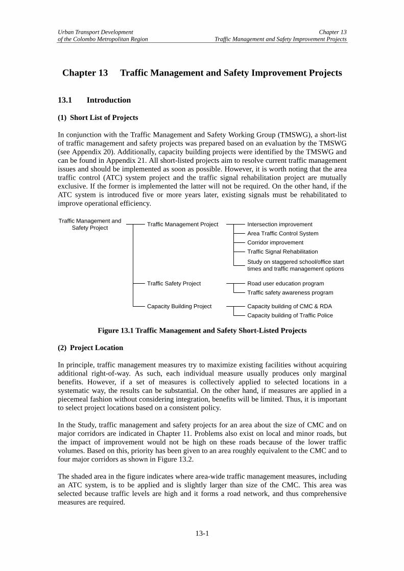
Chapter 13 Traffic Management and Safety Improvement Projects 13.1 Introduction (1) Short List of Projects In conjunction with the Traffic Management and Safety Working Group (TMSWG), a short-list of traffic management and safety projects was prepared based on an evaluation by the TMSWG (see Appendix 20). Additionally, capacity building projects were identified by the TMSWG and can be found in Appendix 21. All short-listed projects aim to resolve current traffic management issues and should be implemented as soon as possible. However, it is worth noting that the area traffic control (ATC) system project and the traffic signal rehabilitation project are mutually exclusive. If the former is implemented the latter will not be required. On the other hand, if the ATC system is introduced five or more years later, existing signals must be rehabilitated to improve operational efficiency. Traffic Management and
Safety Project Traffic Management Project
Traffic Safety Project
Capacity Building Project
Intersection improvementArea Traffic Control SystemCorridor improvement
Road user education programTraffic safety awareness program
Capacity building of CMC & RDACapacity building of Traffic Police
Study on staggered school/office start times and traffic management options
Traffic Signal Rehabilitation
Figure 13.1 Traffic Management and Safety Short-Listed Projects (2) Project Location In principle, traffic management measures try to maximize existing facilities without acquiring additional right-of-way. As such, each individual measure usually produces only marginal benefits. However, if a set of measures is collectively applied to selected locations in a systematic way, the results can be substantial. On the other hand, if measures are applied in a piecemeal fashion without considering integration, benefits will be limited. Thus, it is important to select project locations based on a consistent policy. In the Study, traffic management and safety projects for an area about the size of CMC and on major corridors are indicated in Chapter 11. Problems also exist on local and minor roads, but the impact of improvement would not be high on these roads because of the lower traffic volumes. Based on this, priority has been given to an area roughly equivalent to the CMC and to four major corridors as shown in Figure 13.2. The shaded area in the figure indicates where area-wide traffic management measures, including an ATC system, is to be applied and is slightly larger than size of the CMC. This area was selected because traffic levels are high and it forms a road network, and thus comprehensive measures are required.
13-1

Urban Transport Development Chapter 13 of the Colombo Metropolitan Region Traffic Management and Safety Improvement Projects
There are six radial corridors emanating from central Colombo in all directions except the west. These corridors carry heavy traffic with a typical tidal pattern in the morning and afternoon. On the other hand, traffic volumes on the streets crossing these arterial streets are not as heavy. Thus the improvement measures on these corridors focus on improving or maintaining the current service level of the corridor until more fundamental measures such as widening or new road construction is implemented. Note that only four of these six corridors are taken up as ADB is committed to improving the other two.
Moratuwa
Panadura
Dehiwala
KottawaHomagama
Aturugiriya
Malambe
Kaduwela
KadawathaWelisara
Colombo
Battaramulla
Maharagama
Gampaha
Negombo
Area wide traffic management improvement
Corridor traffic management improvement
Polgasowita
Figure 13.2 Project Locations 13.2 Traffic Management Projects There are five traffic management projects, namely: TM-01: Intersection Geometric Improvement Project TM-02: Area Traffic Control (ATC) System Project TM-03: Traffic Signal Rehabilitation Project TM-06: Corridor Traffic Management Improvement Project TM-11: Study on Staggered School/Office Start Times and Traffic Management Options A description of each project is given below.
13-2

Urban Transport Development Chapter 13 of the Colombo Metropolitan Region Traffic Management and Safety Improvement Projects
TM-01: Intersection Geometric Improvement Projects The project will modify the intersection geometry to enhance both efficiency and safety without acquiring additional right of way. Target intersections will consist of intersections with existing signals and intersections where new signals are planned. As described in Chapter 6, many existing intersections are inadequate in geometric design and lack traffic control devices. Thus there is large room for intersection geometry improvements. Note that both intersection geometry improvement and the ATC system must be implemented together to obtain maximum benefits. Because new geometric design requires upgrading of traffic signals with more functions and vice versa, modification of existing signals is not feasible. At the same time, the project is aimed at enhancing the traffic engineering and management capacity of the staff of relevant organizations through design and implementation of improvement works. The project modifies intersection geometry to enhance both efficiency and safety. Works to be implemented include (i) converting roundabout to intersection; (ii) modifying/removing median; (iii) modifying/removing corner island; (iv) providing right/left turn lane; (v) alignment improvements; (vi) pavement improvements; (vii) sidewalk improvements; (viii) pavement markings; and (ix) traffic sign. Typical works are shown in Figure 13.3. Actual works to be done at each intersection will be selected and designed during the detailed design.
Provision of right turn lane
Sidewalk construction / improvement
Corner island construction
Corner radius adjustment
Median construction / extension
Pavement markings
Pedestrian barrier
Pavement overlay
Traffic sign
Figure 13.3 Intersection Improvement Measures
The project also includes regulatory measures such as banning right turns and implementing one-way, no parking, or no parking and stopping near intersection. These measures are necessary to increase the effective capacity of intersections and prevent traffic congestion. Project Location
Most of the intersections where the new ATC signals are proposed need geometric improvements for the new signals to operate efficiently. Even if geometric improvements are not required, conduit laying work is necessary for all ATC signal intersections, as existing conduit (if any) cannot be re-used for new signaling. Thus, the total number of intersections to
13-3

Urban Transport Development Chapter 13 of the Colombo Metropolitan Region Traffic Management and Safety Improvement Projects
receive geometric improvement is proposed to be equal to the number of proposed ATC signals, which is estimated by the Study Team to be 120 intersections. The type and extent of work for each intersection will be designed together with the detailed design of the ATC system. In this study, works are classified into five types: conversion to intersection, large-scale modification, medium-scale modification, small-scale modification and conduit work only. These are used for initial cost estimates. The estimated number of modifications by type is shown in Table 13.1.
Table 13.1 Estimated No. of Locations Requiring Geometric Improvements
Type of Geometric Improvement No. of locations Conversion of roundabout into intersection 10 locations Large-scale intersection improvement 10 locations Medium-scale intersection improvement 30 locations Small-scale intersection improvement 50 locations Installation of conduit for signal only 20 locations Total 120 locations
One-way System in Cinnamon Gardens
As part of the intersection improvement work, a one-way system in Cinnamon Gardens is proposed as shown in Figure 13.4. Generally speaking, a one-way system makes intersection operation efficient as the number of movements is reduced, making signal coordination easier. On the other hand, travel distances will increase as detours are required due to the restriction. Careful study of the scheme based on the expected change in traffic volume and modification of intersection layout must be carried out before deciding the introduction of one-way system.
Kolpity
Cinamon Gardens
Union Place
Galle Face
Slave Island
Dematagoda
Bambalapitiya
Borella
Figure 13.4 Proposed One-way System at Cinnamon Gardens Pedestrian Overpass/Underpass
Pedestrian overpasses/underpasses are proposed as part of the intersection improvement work. Although these are not convenient for pedestrians, in particular for the disabled, it eliminates traffic accidents involving them and makes traffic movement more efficient. For this reason, pedestrian overpasses/underpasses are proposed at several locations as shown below.
13-4

Urban Transport Development Chapter 13 of the Colombo Metropolitan Region Traffic Management and Safety Improvement Projects
Kolpity
Cinamon Gardens
Union Place
Galle Face
Slave Island
Fort PettahHultsdorf
Mallegawtta
Dematagoda
Meetotamulla
Orugodawatta
Weragoda
Sedawatta
Kotuwila
Kittapahuwa
Wennawatta
Wellampitiya
Megoda Kollannawa
Kolonnawa
Rajagiriya
NarahanpitaTimbrigasyaya
Havelok Town
Pagoda
Pitakotte
MirihanaNugegoda
Kohuwala
KalubowillaDehiwala
Bambalapitiya
Kirillapona
Borella
Madinagoda
Kotahena
GrandpassBluemendhal
Modera
Bluemendhal
Crow Island
Pelliyagodawatta
Kadirana
Pasbetal
Pedestrian Overpass/UnderpassProposed overpass/underpass
Existing overpass/underpass
Figure 13.5 Location of Proposed Pedestrian Overpass/Underpass Benefits
Geometric improvements rationalize vehicle movements in and around intersections resulting in an increase in intersection capacity and traffic safety. Thus, the benefits of the project are:
• Reduction in delays at intersections • Reduction in air pollution • Reduction in traffic accidents
It is not possible to quantify benefits easily for two reasons. First, the reduction in average delays and the resultant reduction in air pollution at a particular intersection vary depending on traffic demand and signal operation. It is possible, however, to obtain an estimated reduction for the given traffic demand and specified signal operation. The total benefits of the system could then be estimated using a traffic assignment model based on simulation results and some assumptions. Second, it is difficult to attribute the reduction in traffic accidents, if any, to
13-5

Urban Transport Development Chapter 13 of the Colombo Metropolitan Region Traffic Management and Safety Improvement Projects
intersection improvement. Moreover, the cost of accidents is hard to estimate although attempts have been made in the past in other similar projects. Risk Mitigation Measures
The improvement works will be carried out within the existing right of way so there will be no risks associated with land acquisition. Intersection geometric improvement works are not technically difficult to design and implement. But design change may be required if unexpected underground obstacles or other problems of construction are found during the work. Attention must be paid to the possibility of such incident. If other works are planned by the agencies such as utility company at or near the intersection, close coordination is required to avoid duplicate works and minimize interruption to traffic flow. Implementing Agency
Intersection improvement at intersections within CMC will be undertaken by it, while those outside the CMC area will be carried out by RDA. Note that there must be coordination between the two agencies regarding design standards so that modification work can be consistent. TM-02: Area Traffic Control System Project An ATC system will be introduced in Colombo, in which all traffic signals in the ATC system area are controlled by the computer at control center to realize efficient traffic control. It is noted that the project must be implemented in conjunction with intersection geometric improvement project, which makes necessary modifications to intersection geometry and constructs footing and conduit lines required for ATC system. ATC system is an advanced type of traffic signal system. All signals in the area are connected via communication lines to a central computer placed at traffic control center. Traffic condition is automatically measured by vehicle detectors installed at strategic key locations in the road network. Central computer calculates the optimum signal timing based on the traffic condition data gathered by vehicle detector and signals operate with the optimum timing. The system has become a standard facility for a city of large and medium size both in developed and developing countries due to its commonly acknowledged benefits. Area Traffic Control (ATC) system addresses mainly the issue of insufficient and inadequate traffic control devices mentioned in Chapter 7 as well as Chapter 10. It also aims at enhancing traffic engineering and management capability of the agencies involved in the project.
13-6

Urban Transport Development Chapter 13 of the Colombo Metropolitan Region Traffic Management and Safety Improvement Projects
TV Camera & Vehicle detector
Traffic Condition
Signal Control
Traffic Information
Control Center
Figure 13.6 Concept of Area Traffic Control System System Configuration
The proposed system consists of the following equipment and facilities:
• Central computer system; • Signal control and associated software; • Video monitor; • Control center facilities (uninterruptible power supply, air conditioning system, etc.); • Local controller and accessories; • Vehicle detector; • Television camera, and • Communication equipment.
Coverage Area
The system will cover all the existing signals within the area indicated in Figure 13.2, which is an area a little larger than CMC, as well as additional signals identified by the Study Team. The locations of these signals are shown in Figure 13.7. The blue dots in the figure depict existing signals to be replaced by ATC signals, while red dots are new signals. There are 87 existing signals and the Study Team has identified 15 additional intersections where new signaling is warranted. The total number of signals in the ATC system is expected to be 120, including some additional signals that will be required by the time the system is introduced.
13-7

Urban Transport Development Chapter 13 of the Colombo Metropolitan Region Traffic Management and Safety Improvement Projects
006
077
048
049
050
051
053
052
056054
055
057
078
079
080
081
083084
085
086
076
073 084083
054 056055
057
037
038
058
059
060
065
064
063
061 062
066
078036
035
034
039
068067
040
030
029031 080
079
033
028032
016
015
014
017022
001 007
018
019
020
008
023
072
009002
044069
042
081
053
052
051010
045
046
047
011003
075
004
050
049
074
005
006
077
085048
076
027 026
025024
070
071
012
013
043
New traffic signal
Proposed Traffic Management Improvement Projects in Colombo
Traffic Signal
Existing traffic signal
073
065
064
063
061
062
060
059
058
066
036
037
038
039
040
030
029
028
031
032
033
034
035
026070
025024
023 027
068067
016
015
014
022
017
020
042
069043
044072
009002
018
019
008
007001
013
012
071
010
003011
047
046
045
075
004
074
005
Figure 13.7 ATC System Coverage Area Project Tasks
The project’s implementation will be divided into the following tasks:
• Detailed design of ATC system and associated works; • Preparation of tender documents and cost estimates; • Contractor selection; and • Procurement and installation of ATC system equipment and supervision.
Detailed design is crucial for the project’s success. As the ATC system will adopt highly advanced computer hardware/software, electronics, communication technologies, and traffic control algorithms. Thus competent engineers well versed and experienced in these fields must be retained to design the new system. On the other hand, knowledge about local traffic conditions is also important for ATC design in order to control traffic efficiently, as the road network, intersection geometry, traffic composition, and driving behavior differ from country to country.
13-8

Urban Transport Development Chapter 13 of the Colombo Metropolitan Region Traffic Management and Safety Improvement Projects
Functional specifications will be prepared as one of the outputs of the detailed design, in which the functional requirements of each piece of equipment, as well as for the whole system, are described. The specifications must be detailed and clear as to what is required for the system, but should not limit the choice by specifying a particular product. Benefits
• Travel time savings: A direct benefit of an ATC system is the efficient operation of signals as they operate with optimum signal timing and adjust themselves automatically to changing traffic conditions. Efficient signal operation results in less congestion, shorter travel time, and cleaner air quality. As Sri Lanka loses Rs. 20 billion annually due to traffic congestion, even a small reduction in the loss would result in substantial benefits.1
• Savings in signal timing adjustment: The existing signals operate with time of day control or fixed time control. These control methods do not adjust timing based on prevailing traffic conditions. Regular review and adjustment of signal timings is thus necessary to keep signal operation efficient. With ATC signals, signal timing is automatically adjusted by detecting traffic conditions, which reduces the need for adjustments by engineers.
• Quick detection of malfunctioning equipment: Another benefit of an ATC system is the ability to quickly detect malfunctioned equipment. If a signal becomes inoperative due to a part malfunctioning or external damage, this is automatically detected by the central computer and remedial action can be taken immediately by maintenance staff. Thus, congestion caused by malfunctioned signals can be minimized.
• Base for future traffic information system: Although not relevant for current conditions, the availability of traffic information is very useful for both road administrators and users. As an ATC system collects traffic flow data for signal control, it can also process this data and provide traffic information such as the degree of congestion, estimated travel time between two points, and recommended routes at congested spots. If an ATC system already exists, it does not require much investment to develop a traffic information system, which would provide real-time traffic information to road users.
Risk Mitigation Measures
There are some risks associated with the introduction of an ATC system and its operation after system completion.
• Organization of Traffic Control Center: A new organization dedicated to the planning, design, installation, operation, and maintenance of the ATC system is required possibly under the Western Provincial Council. Without such organization specifically tasked to construct the system, the project will be difficult to implement.
• System design and system integration: An ATC system is a sophisticated computer system. The design of an ATC system requires knowledge and experience in traffic engineering, computer hardware and software, communications, and civil and electrical works. At the same time, the system design must be suited to local conditions, as a copy of a system from another city would not work well. Therefore, experienced international and local consultants should be involved during the design and construction supervision phases.
• Coordination between CMC, Traffic Police, and RDA: There are two coordination issues to be resolved. The first issue is the ownership of the signals. Currently, all
1 According to the Commissioner of Motor Traffic in an article of The Island on August 26, 2006.
13-9

Urban Transport Development Chapter 13 of the Colombo Metropolitan Region Traffic Management and Safety Improvement Projects
signals in CMC are owned and operated by CMC, except those signals on Baseline Road and some signals on Olcott Mawatha. On the other hand, all signals outside CMC are owned and operated by RDA. If an ATC system is to be introduced, all ATC signals including some signals outside of CMC must be owned and operated by a single body, namely the Traffic Control Center. Second, the Traffic Police are responsible for managing traffic in the field and therefore, desire ownership of the system. However, as they lack the skills needed for operation and maintenance, ownership should be with Traffic Control Center to be established under Western Provincial Council.
• Operation and maintenance set-up: Like other computer systems, an ATC system requires human resources for operation and maintenance and a suitable number of capable operators and maintenance engineers must be available. An annual operation and maintenance budget must be secured for continued system operation. If not, the system will gradually deteriorate.
Implementing Agency
The new organization, the Traffic Control Center, will be established under the Western Provincial Council and will be responsible for designing, installing, operating, and maintaining the ATC system. A new division is required due to the highly specialized skills needed, together with a two-shift operation system to man the ATC at least 14 hours a day. Staff from the CMC, Traffic Police and RDA will be dispatched to the Traffic Control Center for system operation and traffic condition monitoring and for coordination with these agencies. Technical assistance by international consultants during design, construction, and the early stages of operation is essential. The maintenance of the system will be outsourced to a maintenance contractor while the Traffic Control Center will undertake maintenance management.
ATC System Project
Consultant
Road Development Authority(RDA)
Colombo Municipal Council(CMC)
Traffic Police
Traffic Control CenterWestern Provincial Council
Figure 13.8 Set-up of Traffic Control Center TM-03 Traffic Signal Rehabilitation The project rehabilitates both the hardware and signal timing of existing signals. Site inspection will check the condition of equipment to identify the parts to be repaired or replaced, while traffic count surveys will be conducted to design new phases and signal timing. There are 87 existing signals in the CMC and its vicinity (see Figure 13.7). These signals consist of different models and have different manufacturers, and most were installed years ago. Due to insufficient maintenance, many are not in good condition in terms of both hardware and signal timing. All signals operate using time-of-day plans, but signal timing has not been updated for a
13-10

Urban Transport Development Chapter 13 of the Colombo Metropolitan Region Traffic Management and Safety Improvement Projects
while and therefore does not suit the needs of traffic demand. The project will investigate the physical condition of all existing signals and repair or replace defective parts. An intersection turning movement survey will be conducted and new timing plans will be prepared and installed. Modification of signal phasing will be implemented if found effective and possible. Note that signal rehabilitation is a short-term remedy and should only be undertaken if the ATC system is not to be implemented. Otherwise, this project is not required. Benefits
Benefits derived from the proposed signal rehabilitation project will be the same as those seen in the ATC system. However, the magnitude of benefits will be smaller for two reasons. First, the functionality of the existing signals is limited compared with the signals used in an ATC system. Second, the existing signals operate in an isolated fashion, with no coordination between them, which is very ineffective for a signaling system in an urban center. Risk Mitigation Measures
• Capacity of CMC, RDA and maintenance contractor: Existing signals are owned by either CMC or RDA and maintenance is conducted by the respective maintenance contractors of these organizations. Both have few trained traffic engineers familiar with signal design, signal control functions, phase design, and timing parameter calculations. This limited capacity will affect the quality of rehabilitation work and therefore technical assistance is required and a capacity building project proposed for these organizations.
• Availability of spare parts: Most existing signals are manufactured in Sri Lanka, but they use imported devices, components, and parts. Therefore, depending on the type of repairs, spare parts may not be readily available. Second source of spare parts must be secured before the supply by the original supplier becomes unavailable.
• Reliability of signal controller: The reliability of existing signals is low and they require checking, adjustment, and repair routinely. In order to enhance the reliability, malfunction must be recorded and maintenance work schedule must be designed based on the record.
TM-06: Corridor Traffic Management Improvement Project The project aims to make traffic flows efficient and smoother on the selected corridors by implementing a set of traffic management improvement measures without acquiring additional right of way. Instead of applying improvement measures separately to scattered locations, corridors are selected so that improvement measures can be collectively applied in order to obtain benefits. Possible and typical measures are shown below. The measures include intersection improvements and mid-block improvements, as well as soft measures such as no right turn, no parking, and no pedestrian crossing. A one-way system may be introduced if a suitable pair of roads is identified. Actual works to be done will be designed after site surveys along the selected corridors and identification of capacity problems. Only improvement measures not requiring additional right-of-way will be applied. At the same time, the project is aimed at enhancing the traffic engineering and management capacity of the staff of relevant organizations through design and implementation of improvement works.
13-11

Urban Transport Development Chapter 13 of the Colombo Metropolitan Region Traffic Management and Safety Improvement Projects
Traffic sign
Pavement overlay
Pedestrian barrier
Pavement markings
Median construction / extension
Sidewalk construction / improvement
Chatter bar
Traffic signal / Flasher
Delineator
Street lighting
Figure 13.9 Typical Corridor Traffic Management Improvement Measures Project Location
The project will be implemented along four major corridors as shown in Figure 13.2. Intersection improvement measures (see Figure 13.3) will be applied to problematic intersections along the corridor, while the measures shown above will be implemented at mid-block sections. Benefits
Benefits to be gained by the project are similar to those listed in intersection improvements. They are:
• Reduction in delay at intersection; • Reduction in air pollution; and • Reduction in traffic accidents.
As explained previously, quantifying benefits will require a certain amount of simplification and number of assumptions. Risk Mitigation Measures
No serious technical risks are anticipated as additional right of way is not required. However, if the road is widened in the near future, some or all improvement work may be unnecessary. Therefore, programming of the various projects is important to ensure that resources are not misspent. Additionally, if signaling is involved and if it is an ATC signal, coordination with the ATC system project and timely installation of ATC signal will be necessary. Implementing Agency
Improvement works along corridors located in the CMC will be undertaken by CMC, while those outside will be carried out by RDA. As noted above, coordination is necessary with regards to design standards. TM-11: Study on Staggered School/Office Start Times and Traffic Management Options School and commuting traffic is one of the major causes of congestion in Colombo. The project will study the possibility of introducing staggered school and office starting times to lower peak
13-12

Urban Transport Development Chapter 13 of the Colombo Metropolitan Region Traffic Management and Safety Improvement Projects
hour demand, also propose to implement the time staggering expansion under the P-CUT coordination and initiatives consequently. It also will develop traffic management proposals to expand road capacity around the schools and offices in peak hours. As previously discussed in Chapter 3, school start times changed in July 2006 and peak traffic has evened out along particular corridors. Therefore, the JICA Study Team and TMWG believe that implementing further time staggering will positively impact congestion and therefore propose this project as TDM measure. Additionally, as shown in chapter 6, the small traffic management approaches that have been implemented by individual schools and the Traffic Police can be studied and potentially expanded. This project is related to the PT-1 School Transport improvement project. Benefits
Congestion should be reduced during peak hours because if the peak is flattened, congestion will be eased even total demand remains the same. This can happen because congestion occurs only when demand exceeds capacity. By implementing traffic management around schools and offices, those parking on-street will be shifted to off-street areas, increasing road capacity and creating a better traffic environment. Risk Mitigation Measures
• Potential resistance from parents and school van operators: Resistance is expected by those who are negatively affected by the staggered school hours. The TMWG recommended that staggering start times between 15 and 20 minutes would be acceptable to parents and schools van operators. In parallel, flex time for private and government offices should be implemented to give parents flexibility in dealing with the changes in school times.
• Lack of political will: As the measure will restrict the life patterns of some people, strong political will is required for implementation. Staggering hours should be initially proposed to PCUT.
Implementing Agency
MoRT and NTC are in charge for the portion of study and evaluation. After the study, implementation schemes should be initiated with PCUT, and all project idea should be implemented and monitored under the MoRT. The study should embrace all stakeholders including the Department of Education, school associations, principals, the parent teacher associations, Chamber of Commerce, and CMC. It will also be necessary to invite school van operators, private bus operators, SLTB, and international and private schools to participate. 13.3 Traffic Safety Projects Two traffic safety projects are recommended. All are associated with road users. TM-13: Road Users Education Program TM-14: Traffic Safety Improvement Project
13-13

Urban Transport Development Chapter 13 of the Colombo Metropolitan Region Traffic Management and Safety Improvement Projects
TM-13: Road Users Education Program The project will provide knowledge and understanding of traffic rules and manners to road users. It also intends to foster safety awareness among citizens through campaigns, which focus on selected road safety issues. Several programs will be developed, each focusing on different themes and for different road user groups such as pedestrians, cyclists, motorcycle riders, van drivers, and bus drivers. Moreover, the project will support the reopening of the Road Safety Education Park owned by CMC. Undisciplined driver and pedestrian behavior is widely recognized as a serious traffic management issue and major cause of traffic accidents. The project intends to improve road user knowledge and understanding of traffic rules and manners, and increase road user safety awareness. A curriculum will be developed for the different themes and user groups. A series of programs will be launched on a selected theme and an educational program carried out, which will include a roadside campaign, community programs, media advertisements, and TV programs. Enforcement of traffic regulations by Traffic Police will also be strengthened to focus on the theme and user group targeted. Campaign Theme
The theme should be Improve Colombo Drivers’ Manners. The campaign will encourage Colombo drivers to practice good driving manners and to follow traffic rules. It will educate road users of the benefits to follow the rules and being courteous. Road user’s behaviors that will be addressed in the campaign are:
• Observation of traffic signal and regulations; • Method of overtaking: • Method of lane changes; • Priority rule at unsignalized intersection; • Illegal and inadequate parking; and • Jaywalking.
The campaign will use the following measures:
• Direct education of drivers through training, contests, and monitoring; • Propaganda and media coverage in newspapers and TV news; • Road signs, road markings, banners, and panels; • TV, radio, and newspaper advertisements; and • Police programs.
Education program
Three education programs will be developed, each focusing on a different discipline and safety issue. Each program will be carried out for three months, with the total project period being one year, using the first two months for preparation and the last month for review. Under this program, volunteers are recruited to participate in disciplined and safe driving practice. Recruitment can occur through the media or selected from among drivers of government vehicles and bus drivers. They will be given road rule and discipline training and
13-14

Urban Transport Development Chapter 13 of the Colombo Metropolitan Region Traffic Management and Safety Improvement Projects
the media will cover the training. Awards can be given. The training subjects consist of general and program specific subjects. The general subjects include:
• Traffic regulations and rules; • Danger awareness; and • Understanding causes of accidents.
Tentative specific program subjects include:
• Regulation and priority rule at intersections; • Proper use of slow and fast lanes; • Overtaking and lane changing; • Respect of pedestrians; • Proper use of horns; and • Proper parking.
Traffic Safety TV Program
A series of cartoons will be produced to educate people on the dangers of not following traffic rules. The advantage of a cartoon is that it can create accident scenes inexpensively. Each cartoon will focus on a specific dangerous behavior or practice often seen on Colombo’s roadways. Tentative topics include the following:
• Dangerous overtaking; • Reckless or sudden lane changing; • Entry from small road into arterial without stopping; • Disregard of pedestrians at pedestrian crossings; and • Dangers of jaywalking.
The TV program will be broadcasted everyday for four consecutive weeks on popular channels in the Colombo area. The broadcasting time is proposed to be immediately following the morning news program. Media Coverage
Program activities will be covered by the press and the implementing agency will compile and distribute a press brief on the programs every time an event is held. Road Safety Education Park
The CMC-operated Road Safety Education Park in Vihara Mahadevi Park, which was closed in March 2006 due to lack of funding. The project will also fund the preparation of materials and facilities needed to reopen the park, although the operating cost of the park must be funded by CMC. Implementing Agency
The project is to be planned, coordinated, and monitored by the National Council for Road Safety (NCRS). CMC’s Department of Traffic Design and Road Safety will be responsible for re-opening the Road Safety Education Park. Implementation of other project components will be undertaken by the member organizations of NCRS.
13-15

Urban Transport Development Chapter 13 of the Colombo Metropolitan Region Traffic Management and Safety Improvement Projects
National Council for Road Safety
CMC
National Road Safety SecretariatConsultant
Road Safety Education Park Project Component Project Component
Other Member Organizations
Figure 13.10 Implementing Agency of Road Users Education Program Benefits
The expected benefits of the project are a reduction in the number of accidents and their severity. Various activities to be carried out under the program will contribute to change driver and pedestrian behavior gradually. Risk Mitigation Measures
• Reactivate NCRS: Road accidents became a serious national problem in the 1990s, and the Ministry of Transport and Highways established the National Road Safety Secretariat (NRSS) in 1996 to improve road safety in the country. They were tasked with developing a comprehensive set of proposals on road safety. NCRS, which was established in 1986, was legalized under Motor Traffic (Amendment) Act No. 5 (1998) to function as NRSS’s Board of Management. NCRS’s role is to coordinate among various government agencies, the private sector, and NGOs to implement traffic safety measures. Thus, this project would produce the greatest benefits if it were implemented under NCRS. However, the NCRS chairperson position has been vacant since November 2005 and, as of May 2006, NCRS was no longer in operation. The Study Team has been told that the position will be filled soon and once that has occurred, NCRS’s activities will resume. However, until then, this project cannot be undertaken.
TM-14: Traffic Safety Improvement Project The project aims at eliminating existing and potential hazardous accident prone locations by conducting a safety audit and implementing physical as well as regulatory measures. An accident database kept by Traffic Police will be utilized in the identification and analysis of accidents. Traffic accidents are a serious issue in Sri Lanka – more than 2,000 people are killed in traffic accidents every year. Accident records indicate that there are safety issues in the design and conditions of existing roads and therefore, the project will investigate accident records, identify accident prone locations, identify causes of accidents, conduct a safety audit of accident prone locations and sections, develop improvement programs, and implement improvement measures. Currently, the Traffic Police maintain an accident report database using a microprocessor
13-16
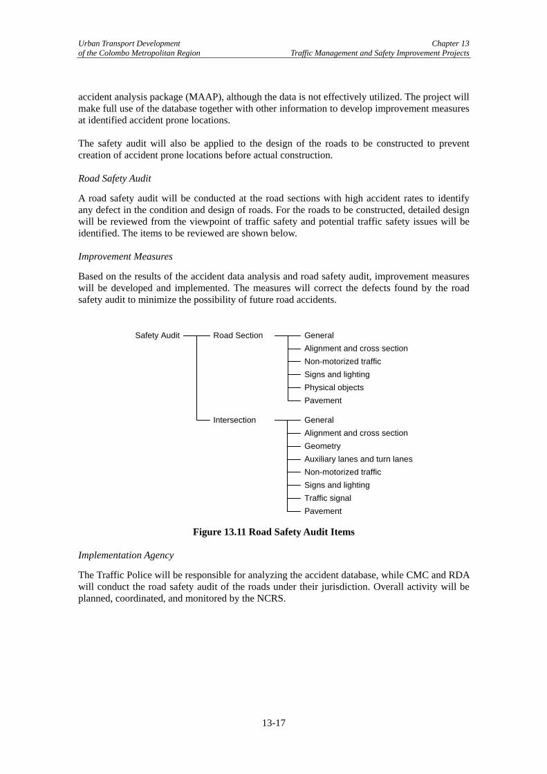
Urban Transport Development Chapter 13 of the Colombo Metropolitan Region Traffic Management and Safety Improvement Projects
accident analysis package (MAAP), although the data is not effectively utilized. The project will make full use of the database together with other information to develop improvement measures at identified accident prone locations. The safety audit will also be applied to the design of the roads to be constructed to prevent creation of accident prone locations before actual construction. Road Safety Audit
A road safety audit will be conducted at the road sections with high accident rates to identify any defect in the condition and design of roads. For the roads to be constructed, detailed design will be reviewed from the viewpoint of traffic safety and potential traffic safety issues will be identified. The items to be reviewed are shown below. Improvement Measures
Based on the results of the accident data analysis and road safety audit, improvement measures will be developed and implemented. The measures will correct the defects found by the road safety audit to minimize the possibility of future road accidents.
Safety Audit Road Section GeneralAlignment and cross sectionNon-motorized trafficSigns and lightingPhysical objectsPavement
Intersection GeneralAlignment and cross sectionGeometryAuxiliary lanes and turn lanes
Traffic signalPavement
Non-motorized trafficSigns and lighting
Figure 13.11 Road Safety Audit Items Implementation Agency
The Traffic Police will be responsible for analyzing the accident database, while CMC and RDA will conduct the road safety audit of the roads under their jurisdiction. Overall activity will be planned, coordinated, and monitored by the NCRS.
13-17
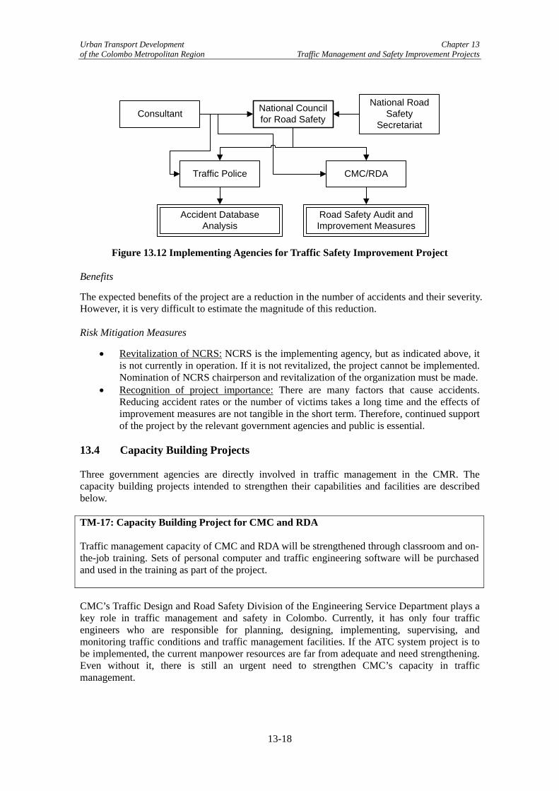
Urban Transport Development Chapter 13 of the Colombo Metropolitan Region Traffic Management and Safety Improvement Projects
National Council for Road Safety
Traffic Police
National Road Safety
SecretariatConsultant
Accident Database Analysis
Road Safety Audit and Improvement Measures
CMC/RDA
Figure 13.12 Implementing Agencies for Traffic Safety Improvement Project Benefits
The expected benefits of the project are a reduction in the number of accidents and their severity. However, it is very difficult to estimate the magnitude of this reduction. Risk Mitigation Measures
• Revitalization of NCRS: NCRS is the implementing agency, but as indicated above, it is not currently in operation. If it is not revitalized, the project cannot be implemented. Nomination of NCRS chairperson and revitalization of the organization must be made.
• Recognition of project importance: There are many factors that cause accidents. Reducing accident rates or the number of victims takes a long time and the effects of improvement measures are not tangible in the short term. Therefore, continued support of the project by the relevant government agencies and public is essential.
13.4 Capacity Building Projects Three government agencies are directly involved in traffic management in the CMR. The capacity building projects intended to strengthen their capabilities and facilities are described below. TM-17: Capacity Building Project for CMC and RDA Traffic management capacity of CMC and RDA will be strengthened through classroom and on-the-job training. Sets of personal computer and traffic engineering software will be purchased and used in the training as part of the project. CMC’s Traffic Design and Road Safety Division of the Engineering Service Department plays a key role in traffic management and safety in Colombo. Currently, it has only four traffic engineers who are responsible for planning, designing, implementing, supervising, and monitoring traffic conditions and traffic management facilities. If the ATC system project is to be implemented, the current manpower resources are far from adequate and need strengthening. Even without it, there is still an urgent need to strengthen CMC’s capacity in traffic management.
13-18

Urban Transport Development Chapter 13 of the Colombo Metropolitan Region Traffic Management and Safety Improvement Projects
RDA is responsible for the construction and maintenance of major roads in the country, as well as road operation and traffic management. Although they have many road and civil engineers, their capacity in traffic management is still weak. This project intends to strengthen the capacity of RDA in traffic management by conducting training and providing the necessary facilities. The project will add additional human resources, conduct training, and provide the necessary equipment. Manuals and standard specifications for equipment and devices used in traffic management will be developed jointly by CMC, RDA and other relevant agencies. Methodology
Developing and applying traffic management measures require basic and practical knowledge of traffic engineering subjects. The tentative subjects of the training will be:
• Traffic flow theory; • Traffic count survey; • Intersection capacity; • Intersection design; • Signal operation and design; • Vehicle detector; • Road markings; • Traffic sign; • Parking management; and • Traffic safety.
Almost all of these subjects are essential to design the ATC system and on-the-job training will be held during the design stage of the ATC system project by the international consultants working on the project. If the ATC system is not implemented, relevant international experts will be invited to provide classroom and on-the-job training on signaling rehabilitation and other traffic management measures to be implemented by CMC and RDA. Facilities
Use of personal computers and traffic engineering software will make traffic management more efficient. There are many off-the-shelf traffic engineering applications that can be used to analyze, plan, design and evaluate traffic management measures. The applications include:
• Geographic Information System (GIS) for traffic management facilities; • Traffic count survey data processing; • Macro and micro traffic simulation programs; • Signal design software; and • Computer aided design (CAD).
Benefits
• Efficient and safe traffic management design: Training on traffic management and developing standard designs will improve the quality of work undertaken by CMC and RDA. Traffic flows will be more efficient and safer if design is suitable. Note that even a small savings per vehicle will produce substantial benefits for the entire road network.
13-19

Urban Transport Development Chapter 13 of the Colombo Metropolitan Region Traffic Management and Safety Improvement Projects
• Reduction in congestion: As a result of better design and effective traffic control devices, traffic flows will be smoother and congestion will be reduced. Completely alleviating congestion will be difficult as traffic demand will continue to increase over time, but without the changes, congestion would become much more severe.
• Standardization: Consistency and standardization are important in the design and application of traffic management measures to avoid confusing road users. The project will promote the same design standards in traffic management.
Risk Mitigation Measures
• Strong initiative by top level officials: Traffic congestion problems are well recognized by residents of the CMR. However, because traffic conditions deteriorate gradually and their negative impact is not significant for one individual, actions are often not taken in a timely manner. Therefore, top officials must understand the seriousness of traffic congestion in order to alleviate it.
• Establishment of Traffic Control Center: The ATC system project requires a dedicated organization from the planning stage. If it is not established and the project is conducted by external individuals only, valuable opportunity of on-the-job training will be lost and efficient operation and maintenance of the system will likely not occur.
• Coordination/cooperation between CMC and RDA regarding design standards and specifications: Coordination between CMC and RDA has not been close in the past and therefore each organization has its own standards and specifications. In order to establish consistency for the traffic management schemes and design, coordination must be enhanced. It is hoped that capacity building program will be held jointly by CMC and RDA to help promote the coordination.
TM-19: Capacity Building Project for Traffic Police The project will establish a Police Driving Training School, where police drivers will be trained. The facility will be used for training the general public once a training program has been developed. Traffic Police are responsible for guiding traffic on the roads and enforcing traffic laws and regulations. With the expected increase in the number of vehicles and worsening traffic conditions, the importance of their role will continue to grow and their activities must intensify. The number of traffic police on duty in CMC decreased between 1995 and 1999.2 Recently, efforts have increased and there are now 547 policemen, which exceeds1995 levels. The training program at the Police Training College in Kalutara and Traffic Police Headquarters at Fort has also increased. Therefore, instead of reviewing the training curriculum, this capacity building program will focus on developing a Police Driving Training School, which the Traffic Police are now contemplating. The project aims at addressing undisciplined road users. Although trainees are policemen at the start of school, they are expected to be a model for other drivers. Furthermore, it is envisioned that the training course will be expanded to cover ordinary drivers.
2 Table 7.2 of Working Paper 26: Institutional Proposals for Traffic Management, Colombo Urban Transport Study Stage 2, indicates the decrease.
13-20
Urban Transport Development Chapter 13 of the Colombo Metropolitan Region Traffic Management and Safety Improvement Projects
Police Driving Training School
The proposed Police Driving Training School is tasked with teaching the police proper driving rules and manners and educating them to be model drivers. At the same time, the facility will be used to train the traffic police how to direct or guide traffic. It is also planned that the school deal with the general public, such as frequent traffic law violators or those who have committed a serious traffic offence or caused a severe traffic accident. Large companies that employ many drivers, such as a freight forwarding company, will be encouraged to hold training at the facility for a fee. The facility will consist of an open-air driving course of adequate size, passenger car and motorcycle driving simulators, classrooms, and associated facilities. The driving course will have a variety of road sections including straight sections, curves, intersections, hills, and curbs where trainees will practice driving techniques and manners. As noted above, there will be a car and motorcycle driving simulator at the facility. Both types have a driving mechanism (steering wheel or handle, accelerator, and brake) and seat similar to those of real vehicles. A large screen will be setup in front of the vehicle and the screen will replicate a real driving scene, which moves as the vehicle is operated and rotates as driver makes a turn. The benefit of a simulator is that dangerous situations are easily produced and experienced by the driver. Benefits
• Improvement of driving manners of police: Most police use vehicles for their daily use and the operation and behavior of such vehicles should present a model to other citizens.
• Improvement of driving manners of general public: Once the training program has been established, the facility can be used to train the general public. Although the impact of the training would not produce immediate changes, the long term effects such as a comfortable driving environment and a decrease in the number of accidents would be beneficial.
• Decrease in number of traffic accidents: Dangerous or reckless driving is often the cause of accidents. Therefore, if driving skills are improved, the number of traffic accidents should decrease.
Risk Mitigation Measures
• Understanding & cooperation from top-level officials: For a capacity building project to be successful, understanding and cooperation by top level officials is vital. Otherwise, the project will be unsuccessful. Efforts must be exerted to obtain understanding and recognition of the importance of the project by the top level officials of Traffic Police.
13-21

Urban Transport Development Chapter 13 of the Colombo Metropolitan Region Traffic Management and Safety Improvement Projects
13-22

Urban Transport Development Chapter 14 of the Colombo Metropolitan Region Public Transport Improvement Projects
Chapter 14 Public Transport Improvement Projects 14.1 Introduction As outlined in Chapter 11 of this report, the Study Team worked with the Public Transport Working Group (PTWG) to identify and evaluate the public transport projects in the Long List of Projects (Appendix 1). This chapter focuses on the results of the evaluation – the short-list of public transport projects. Once the evaluations were complete, the Study Team refined the projects and discussed them with decision-makers at each implementing agency. 14.2 Bus Improvement Projects Based on PTWG’s evaluation of the Long List of Projects, the following bus sector improvement projects were short-listed (See Section 11.2 for evaluation criteria). (1) Concessioning Private Sector Bus Routes Franchising has been recommended repeatedly to improve bus services and different options have been included in previous studies and reports. However, it has yet to be implemented in Western Province. The Study Teem feels that it is still the best mechanism to improve bus services, but there seem to be some negative associations with franchising. Through discussions with private sector, provincial, and national government stakeholders, it is clear that there are some misunderstandings regarding franchising. Therefore, before a pilot franchising project can be implemented, franchising education should be undertaken to eliminate misunderstandings.1 This education is covered in the capacity building projects below. Franchising cannot be implemented without a commitment to restructure and develop public sector institutional capacity, which requires the government’s dedication and continuity. Additionally, because of the high negative association surrounding the use of the term franchising, the Study Team recommends using the term “concessioning” to be used, instead of franchising, in an attempt to eliminate negative judgment of the project. Franchising and concessioning both enable the exclusive right to operate a route or set of routes, usually as a result of competitive bidding. The difference between the two is that in a franchise, the authority takes a financial responsibility for the provision of services, providing a subsidy if the fares are not sustainable, giving the authority more influence over the provision of services. The concepts are explained in Appendix 22 along with international examples and other resources (web sites, documents). Short-List Projects
Based on the above, the Study Team recommends the following project: Bus-1: Technical Assistance to Lay Groundwork for Bus Route Concessioning and Undertake a Pilot Concessioning Project Undertake pilot concessioning project on routes 119, 138, 144, and 148. Undertake steps to enable the implementation of full urban bus route concessioning, including rationalizing the
1 The main misconception is that franchising or concessioning is a monopoly. Yes, the outcome is that one operator is tasked with providing services on a route, which eliminates competition on the route. However, unlike a monopoly, concessioning has competition for the route and has multiple companies bid for a route, with the best proposal receiving a contract which stipulates certain parameters that must be met. Additionally, the regulator of the contract is able to enforce the contract through monitoring and enforcement of the penalties in the contract.
14-1

Urban Transport Development Chapter 14 of the Colombo Metropolitan Region Public Transport Improvement Projects
route network, developing service parameters, creating tendering documents, and route rationalization and implementing and monitoring full urban bus route concessioning. Pilot Project
As it is pointed out in Chapter 7, the quality of bus services is quite low in Colombo. Among the issues noted by the Study Team are poor bus conditions, unsafe driving, long in-bus travel times, unprofessional driver/conductor behavior, low frequency of service during off-peak periods, and crowded buses. Most private buses are owned by individual operators, which make the regulatory authority difficult to manage each operator’s service quality and provision of services. In 1996, regulation was passed to require bus operators to merge to form entities which would provide some semblance of management oversight, both from the entity and the regulator. However, the regulation was quite broad and provided no specifications for the entities (i.e. LLC, loose associations, management style, facilities, etc.), so the result was the agglomeration of buses on each route into route associations. A pilot project is necessary in order to gain the confidence of the bus operators and regulators, the Western Province Road Passenger Transport Authority (WPRPTA), with assistance from the National Transport Commission (NTC). It will also help to clarify implementation issues before a large scale implementation. Based on the aforementioned issues, the Study Team identified the scheme of concessioning of bus routes as the most appropriate option to reform bus services in Colombo. The pilot project would aim to meet the following objectives: introduce competition for the right to supply bus services, encourage corporitization, create a level playing field for this competition, and clearly separate the operating function from the regulatory function. It is envisioned that the pilot project, through the issuance of contracts for the operation a specified route or a specified group of routes, would be implemented on a few low/medium demand routes, entirely private sector operated,2 where rotated timetables are in use, and where the bus operators/route association is flexible and amenable to the experiment. In discussions with WPRPTA officials, potential routes include 119 (Dehiwala-Maharagama), 138 (Homagama -Pettah), 144 (Rajagiriya-Pettah), and 148 (Kaduwela-Pettah), which are mapped in Figure 14.1.
2 Private sector operated only so that any changes in Sri Lanka Transport Board (SLTB) strategy don’t affect the concession
14-2

Urban Transport Development Chapter 14 of the Colombo Metropolitan Region Public Transport Improvement Projects
Figure 14.1 Map of Routes for Pilot Concession Project
Given the (i) pilot status of the project; (ii) lack of companies to make a viable bid; and (iii) potential difficulty in removing incumbent operators from a route if they were to bid unsuccessfully, it is recommended that the concession for the pilot routes be awarded to the associations without competition bidding. However, proper concession documentation must be generated, indicating fares and fare policy, service levels, and duration of contract.3 Prior to discussing the pilot project with the operators, NTC and WPRPTA, with assistance from consultants, should hold meetings with relevant politicians at both the national and provincial levels to discuss their plans for the pilot project and how the permits would work, as well as the benefits and risks associated with concessioning and their long-term goal in implementing it in Colombo. WPRPTA will also need to outline the parts of the contract that cannot be changed, such as consistency of the fare policy and the requirement that SLTB not attempt to operate on the pilot routes and obtain agreement from the relevant stakeholders (Western Provincial Council, Parliament, and the Minister of the Ministry of Railways and Transport). Both the Western Provincial Council (WPC) Provincial Road Passenger Carriage Services Statute No. 1 (1992) and the NTC Amendment Act will need to be changed to allow for competitive bidding and modify the operational permits.4 Additionally, WPRPTA should create rotated timetables for the proposed pilot routes and implement them as soon as possible so that the bus operators become accustomed to them. Once the pre-conditions are met, the WPRPTA General Manager should meet with each of the route associations and bus operators on the proposed pilot routes to discuss the pilot project, clarify their issues, and obtain consensus on their participation for the duration of the concession. It must be made clear that this is a binding contract between the association and WPRPTA, with clearly defined expectations and consequences. Those associations who respond positively and 3 The Study Team recommends two years maximum for pilot concession duration. 4 Modify both the NTC Amendment Act and the WPC Provincial Road Passenger Carriage Services Statute No. 1 (1992) to allow for the concessionaire (i.e. not the owner of the bus) to obtain a permit and lease/rent buses (currently permits are given to owner/operators, but with concessioning they may be separate entities). Of course, the concessionaires can also be the owners of buses, but this need not always be the case.
14-3
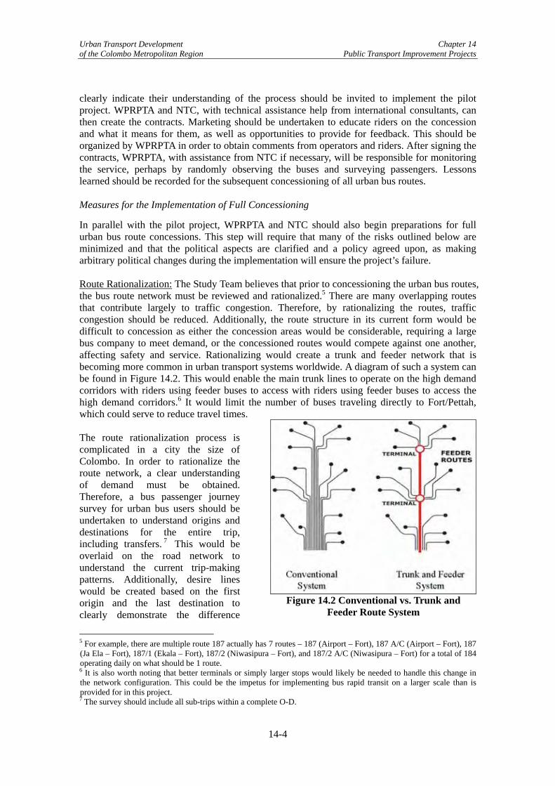
Urban Transport Development Chapter 14 of the Colombo Metropolitan Region Public Transport Improvement Projects
clearly indicate their understanding of the process should be invited to implement the pilot project. WPRPTA and NTC, with technical assistance help from international consultants, can then create the contracts. Marketing should be undertaken to educate riders on the concession and what it means for them, as well as opportunities to provide for feedback. This should be organized by WPRPTA in order to obtain comments from operators and riders. After signing the contracts, WPRPTA, with assistance from NTC if necessary, will be responsible for monitoring the service, perhaps by randomly observing the buses and surveying passengers. Lessons learned should be recorded for the subsequent concessioning of all urban bus routes. Measures for the Implementation of Full Concessioning
In parallel with the pilot project, WPRPTA and NTC should also begin preparations for full urban bus route concessions. This step will require that many of the risks outlined below are minimized and that the political aspects are clarified and a policy agreed upon, as making arbitrary political changes during the implementation will ensure the project’s failure. Route Rationalization: The Study Team believes that prior to concessioning the urban bus routes, the bus route network must be reviewed and rationalized.5 There are many overlapping routes that contribute largely to traffic congestion. Therefore, by rationalizing the routes, traffic congestion should be reduced. Additionally, the route structure in its current form would be difficult to concession as either the concession areas would be considerable, requiring a large bus company to meet demand, or the concessioned routes would compete against one another, affecting safety and service. Rationalizing would create a trunk and feeder network that is becoming more common in urban transport systems worldwide. A diagram of such a system can be found in Figure 14.2. This would enable the main trunk lines to operate on the high demand corridors with riders using feeder buses to access with riders using feeder buses to access the high demand corridors.6 It would limit the number of buses traveling directly to Fort/Pettah, which could serve to reduce travel times.
Figure 14.2 Conventional vs. Trunk and Feeder Route System
The route rationalization process is complicated in a city the size of Colombo. In order to rationalize the route network, a clear understanding of demand must be obtained. Therefore, a bus passenger journey survey for urban bus users should be undertaken to understand origins and destinations for the entire trip, including transfers. 7 This would be overlaid on the road network to understand the current trip-making patterns. Additionally, desire lines would be created based on the first origin and the last destination to clearly demonstrate the difference
5 For example, there are multiple route 187 actually has 7 routes – 187 (Airport – Fort), 187 A/C (Airport – Fort), 187 (Ja Ela – Fort), 187/1 (Ekala – Fort), 187/2 (Niwasipura – Fort), and 187/2 A/C (Niwasipura – Fort) for a total of 184 operating daily on what should be 1 route. 6 It is also worth noting that better terminals or simply larger stops would likely be needed to handle this change in the network configuration. This could be the impetus for implementing bus rapid transit on a larger scale than is provided for in this project. 7 The survey should include all sub-trips within a complete O-D.
14-4

Urban Transport Development Chapter 14 of the Colombo Metropolitan Region Public Transport Improvement Projects
between where riders want to go and where they are forced to go in the current network. A route planning specialist will utilize the above data to rationalize the route network. The new network should be designed to include the intermodal stations to be built in projects Road-49 and Road-50. To reduce competition on the route, routes should be divided into routes to be operated by the public sector and routes to be operated by the private sector, ensuring that profitability is maintained for each.8 That is, routes should not be continued to be operated by both.9 The new rationalized network could then be divided into areas, which either the group or individual routes will be concessioned in a rolling manner, to be outlined by the Concessioning Specialist. Service Parameters: In the concessioning contract, service level parameters must be identified by the regulator to insure a pre-specified level of service, including hours of operation. However, it is also necessary that the regulators do not overregulate the operators, so as to provide them with flexibility to be innovative with their services. Minimum timetables (or perhaps simply minimum frequencies for trunk routes) may need to be created in order to ensure minimum levels of service, as well as to provide the initial bidding operators with a clear understanding of the inputs into the service. In parallel, any other service parameters should be developed and gazetted, including vehicle standards with regards to maintenance and driver standards, such as training and payment of benefits (EPF/ETF).10 Preparation of Tender Documents: Lastly, tender documents will need to be created that clearly outline the service parameters, concession parameters, and the evaluation methodology. The documentation should be as transparent as possible. The evaluation methodology could include a performance rating scheme (i.e. number of complaints, number of accidents) which takes into account previous quality of service; although this too would need to be clearly defined and transparent. To have the current operators accept the new route network, the government may need to directly concession the routes to specific route associations for the first round of tendering and all subsequent rounds would be opened to competitive bidding. Monitoring and Penalties: Once the route has been concessioned, the regulators will need to continue to monitor services, both through feedback from riders through surveys and a customer service hotline, as well as by randomly observing buses in operation. As outlined in the contract, penalties for not meeting the contract must be imposed and it is important that there is no political intervention, as the penalties are the basis for the regulators to maintain levels of service in the bus sector. Lessons learned should also be gathered and utilized for subsequent rounds of concessioning. Benefits
Concessioning can provide numerous benefits to the government, operators, and the public. For the government:
• Consolidation of the Bus Industry: Creates favorable conditions to consolidate the bus industry into larger, more manageable companies that have the ability to provide
8 This varies from the current network where some routes are operated by both SLTB and the private sector. 9 In theory, routes could be operated by both and then the private sector market share could be concessioned. However, this would require a clear SLTB strategy, would lock each sector into a pre-defined modal share reducing the incentives for improvement, retain competition on the route, and would result in no one being solely responsible for the overall level of service on the route. The only benefit is that if a strike were to occur, service could still be provided by the other operator. However, concessioning should reduce the likelihood of strikes, since many of the reasons for strikes (fares, etc.) will be clearly outlined in the contract. 10 The service parameters should not be too specific, such as in the NTC Amendment Act where all formed companies had to have at least 50 buses. Instead, it should clearly state that the company must have enough buses to meet demand as well as provide for buses in the event of a breakdown or accident.
14-5

Urban Transport Development Chapter 14 of the Colombo Metropolitan Region Public Transport Improvement Projects
services for an entire route. This change would increase the ability to regulate the industry by reducing the number of organizations that need to be regulated.
• Increases Bus Service Provisions: Introducing competition for the market will produce a secure contract that works as an incentive to improve service for the right of operating a specific route.
• Control Service Parameters: Concessions allow regulators to stipulate service parameters in the contract, which help to improve levels of service.
• Control Route Network: The route network is defined by the regulator, allowing changes and modifications to be made prior to each concession.
• Continue the Regulation of Fares: Concessioning allows regulators to continue to regulate fares, as long as the review process and policy is clearly defined and implemented on a previously determined schedule and accounts for operator financial viability.
• Increase Market Responsiveness of the Sector: By concessioning a route as a whole, responsibility for responding to changes in demand will be shifted to the operator on that route, as opposed to the current situation where the government must provide an additional permit for a bus to handle increased demand. (Alternatively, in the current system, in the case of reduced demand, buses are not removed, thereby increasing competition and lowering profitability and efficiency of all buses.)
For the operators:
• Increase Operational Freedom: Within the confines of the service parameters, the operators are able to operate freely and maximize their assets and crew. They would be able to hire qualified crew and maximize their productivity/utilization since all crew would be trained to drive all company buses. The buses themselves will have more turns, thereby increasing the productivity/utilization of each asset. Since a concession increases the focus on the long-term, maintenance methods should improve as they will help to maximize the longevity of the asset.
• Reduces Control by Informal Sector: Currently, the informal sector is heavily entrenched at some bus stations, requiring payments and generally increasing the difficulty of operations for private bus operators and crew. Concessions should help to reduce the control of the informal sector since larger companies will be created that will be less vulnerable to extortion in comparison to individual private operators.
• Reduce Government Interference with Operations: Once the concession is awarded, unless there are any substantial violations to the contract, the operator should be able to operate without government interference, reducing the risks to his operation and insuring a smoother daily operation.
• Income Stream for the Length of the Concession: Unless there are significant changes in demand or the concession is cancelled due to violations to the contract, operators involved in a concession will have a seemingly guaranteed income stream for the duration of the concession, allowing them to plan and invest in the future (i.e. new buses, training for drivers, etc.).
• Clear Regulatory Framework: A clear regulatory framework, the basis of concessions, balances the operators’ freedoms, with clearly defined obligations, which provides incentives to improve performance and service offerings.
For the passengers and general public:
• Increase Safety: Competition on the roadway is eliminated and revenues are earned by the company, therefore, the drivers can reduce their focus on daily profits which lead to speeding between stops.
14-6

Urban Transport Development Chapter 14 of the Colombo Metropolitan Region Public Transport Improvement Projects
• Increase Level of Service: As the service parameters will be clearly defined in the contract, along with penalties for non-compliance, and riders should see a gradual improvement in the level of service provided, including less crowding, better qualified drivers, acceptance of all categories of passengers, including disabled, priests, and students. Reliability should also increase, although of course, traffic congestion will still be a factor in on time service. Additionally, early morning, late night, and weekend services would be guaranteed, as their provision would be stipulated in the contract.
• Increase Demand Responsiveness: As they are solely responsible for the provision of services on the route, the concessionaire has more incentive to respond to changes in demand on the route (or within the area) to continue to provide a good level of service. Within the company, they will be more able to respond quickly by adding another bus to the service (or removing it) in order to maintain profitability and meet contract requirements.
• Reduce Traffic Congestion by Reducing Buses on High Demand Corridors: Rationalizing the routes and increasing the companies’ focus on profitability should result in less congestion due to buses.
• Increase in Intermodal Focus: To increase ridership, more attention will be paid to providing a service that meets passengers’ needs, including transfers from/to other buses and trains.
Risk Mitigation Measures
There are a number of risks associated with the implementation of full concessioning in Colombo and many of the risks must be clarified prior to undertaking full concessioning, along with mitigation measures, otherwise the project will likely be unsuccessful.
• Strong Government Commitment: A firm commitment to a public transport strategy, which includes concessioning, is currently lacking at both the Central and Provincial governments. This risk can be lessened by undertaking capacity building on concessioning and other relevant topics, as well as implementing pilot concessioning projects that demonstrate the benefits. But the high turnover in these positions makes sustainability of the commitment difficult.
• Strong Consistent Government Policy: This follows directly from the lack of government commitment to concessioning, as it constitutes a radical change in the provision and regulation of bus services and will be difficult to implement without a clear, consistent and published policy statement that eliminates the opportunity for political intervention. Policies for bus operations include the role of SLTB, fare reviews, transport of disabled, elderly, students, among others. The constant changing of these policies arbitrarily breeds distrust between the operators and the government, further heightening the risks associated with concessioning. Policies would also have to be created with the view to incentivize industry restructuring from associations limited by guaranty to fully corporate companies. Additionally, as addressed above, the purpose of concessioning is to have competition for the market to improve services – that is to tender concessions through competitive bidding.11 This is not addressed in any transport law to date.
• Strong Clear Legal Basis: Both the WPC Provincial Road Passenger Carriage Services Statute No. 1 (1992) and the NTC Amendment Act must be modified to allow for and encourage concessioning of bus routes. Additionally, the WPC Provincial Road Passenger Carriage Services Statute No. 1 (1992) provides “a passenger service permit
11 The first round of concessioning could occur without competitive bidding, although it should be made clear that all subsequent tenders will be undertaken competitively.
14-7
Urban Transport Development Chapter 14 of the Colombo Metropolitan Region Public Transport Improvement Projects
(to be) issued … (to) entitle the holder thereof to use an omnibus of which he is the registered owner for the operation of a regular service for the carriage of persons on the route or routes specified in such permit…”12 At the beginning of the concessioning process, it is highly unlikely that the tendering company will own all of the buses and will likely lease the buses from the individual operators, thereby separating owners and operators.
• Role of SLTB and Vested Interests in Supporting SLTB: A clear government strategy with regards to SLTB needs to be created prior to concessioning and should include acceptance and implementation of WPC regulations that have arisen from the 13th Amendment of the Constitution. SLTB currently receives substantial and unsustainable government subsidies in the form of buses and operating subsidies, as well as considerable protection in operations. This does not provide fair competition with the private sector and enables government officials to believe that the private sector supports SLTB, when in fact; it is the reverse as the private sector carries 71.5% of passenger km in WP.13 Therefore, to mitigate this risk, a SLTB urban transport strategy is necessary. Additionally, when the new route network is generated, private sector routes should be separated from SLTB routes, such that protectionism will be unnecessary and competition between the two will be reduced.
• Strong Regulatory Capacity: Concessioning requires a strong regulator to impose standards of service and safety, create and maintain network development plans, and monitor their implementation during the concession. They also must be able to make decisions logically that apply to all concessionaires, as opposed to the current arbitrary nature that results from outside interests. The capacity building projects that follow are projected to strengthen the regulators, although clear policies, a legal basis, and government commitment will go much further in strengthening the regulators. This would help to ease the fears that bus companies will become monopolies and impossible to manage.
• Consistency in Application of Fare Policy: If fares are to be set by the government, they must allow for the operators to make a profit and the annual review clearly defined. A fare policy currently exists and fares are evaluated annually (July), as well as when there are increases in operating costs (i.e. fuel increases), but the policy itself has not been passed by Parliament and therefore is still subject to ministerial and political interference.
• Strong Private Sector Interests: According to the private sector representatives on the PTWG, there is interest in implementing concessioning, although the Study Team suspects that the operators do not have a clear idea of what concessioning is or what changes it would entail, such as competitive bidding for the concession, route rationalization, and strengthening of regulator. There is also the likelihood that by consolidating operators, some operators could be unemployed, which will not be received well.14 As there is a level of distrust between the private operators and the government, incentives and clear policies will need to be implemented, since in order to be successful, concessioning should balance the risks between the operator and the regulator.
• Change Private Sector Mindset: The private sector is focused on daily profits, with little attention to next month or next year. Concessioning will require that the private sector think completely differently and it is unclear if the operators are interested in this
12 Western Province Provincial Council of the Democratic Socialist Republic of Sri Lanka, Provincial Road Passenger Carriage Services Statue No. 1 of 1992, Part 1, Section 10. (As written in the English version of the Statute) 13 Chapter 7 of this report. 14 A one-time pay out, similar to a voluntary retirement scheme, could be implemented to those operators being eliminated from the sector.
14-8

Urban Transport Development Chapter 14 of the Colombo Metropolitan Region Public Transport Improvement Projects
change. The pilot project will help implement this change, assuming that the project is successful.
• Raising Awareness: A lack of understanding of the concept of concessioning is pervasive throughout the government and private sector. Targeted capacity building should improve the knowledge base.
(2) Construct Bus Rapid Transit System15 BRT-1: Bus Rapid Transport System Conduct a pre-feasibility study to ultimately design, and construct a ~20 km bus rapid transit (BRT) system along a Coastal Route and a route connecting Fort/Pettah with Kotte (exact alignment to be determined). The Kotte route would provide access to Battaramulla and the Sethsiripaya Administrative Complex. This would be the first phase of a new high-capacity public transport system for Colombo. Project Description
Bus rapid transit (BRT) merges the quality of rail transit with the flexibility of buses. A BRT system combines rapid and convenient fare collection, high-tech vehicles, dedicated lanes, modern bus stations, and more frequent service. BRT often looks and operates like light rail but at a considerably lower cost. The Study Team recommends a BRT system as a balanced approach to accommodate future travel demand over the next several years and to overcome pertinent issues passengers are facing, such as overcrowding on buses, irregular or unpredictable service frequencies particularly during off-peak hours, lack of interchange facilities for the efficient transfer of passengers from bus to rail and vice versa, and lack of adequate regulation to ensure that services are operated in line with government policy. BRT has been successfully implemented in a number of cities worldwide and Sri Lanka is keen to build upon such international experience to improve public transport provision in Colombo. Therefore, after reviewing a proposal from the Urban Development Authority (UDA), the Study Team believes that this UDA proposal can be incorporated into a larger BRT system that would provide rapid bus services connecting Dehiwala and Kotte along a Coastal Route through Fort to Kotte along the Kelani Valley Line right-of-way to Talangama. The Kotte route would incorporate the Sethsiripaya Administrative Complex (Sethsiripaya) to enable the transport of government employees and other staff working in Battaramulla. In some parts, the project would consist of an exclusive busway, while in others, bus lanes to form an approximately 20 km long BRT route with a total of 24 stops with terminal facilities at Dehiwala and Talangama (beyond Battaramulla). Figure 14.3 shows the proposed route of the busway and location of the stops, although the exact alignment is yet to be determined.
15 Appendix 25 provides more information on BRT proposal as well as the basics of BRT, benefits, a list of international examples, and a list of additional resources.
14-9

Urban Transport Development Chapter 14 of the Colombo Metropolitan Region Public Transport Improvement Projects
Figure 14.3 Potential BRT Route and Location of Stops The main objectives of implementing BRT are to:
• Introduce a new cost effective public transport system to Colombo; • Expedite development of the Sri Jayawardhanepura Kotte (Kotte) new capital city
development program; • Reduce traffic congestion by attracting both private vehicle users and private and
public bus passengers; • Reduce traffic congestion on major corridors by creating trunk routes in exclusive
lanes (eliminating bunches of buses), leaving other lanes for private vehicle use; • Improve efficiency of public transport system, thereby providing viable alternatives to
private transport; • Provide a convenient public passenger transport system; • Improve quality of both natural and built environment in Colombo; and • Provide a system to integrate different public transport systems (i.e. rail, bus, water
etc.). The proposal above parallels the light rail transit system proposed in the Western Regional Megapolis Plan (WRMP). The BRT busway would run between Battaramulla and Dehiwala with terminal facilities at the ends for transfers to feeder routes and inter-district routes. In Kotte, Sethsiripaya (at Battaramulla) is partially completed and at the conclusion is expected to provide one million square feet of office space to accommodate the majority of public sector institutions that remain in Colombo’s central areas. It is expected that if the system is properly operated, international experience demonstrates that the service capacity of BRT can exceed that of light rail transit.
14-10
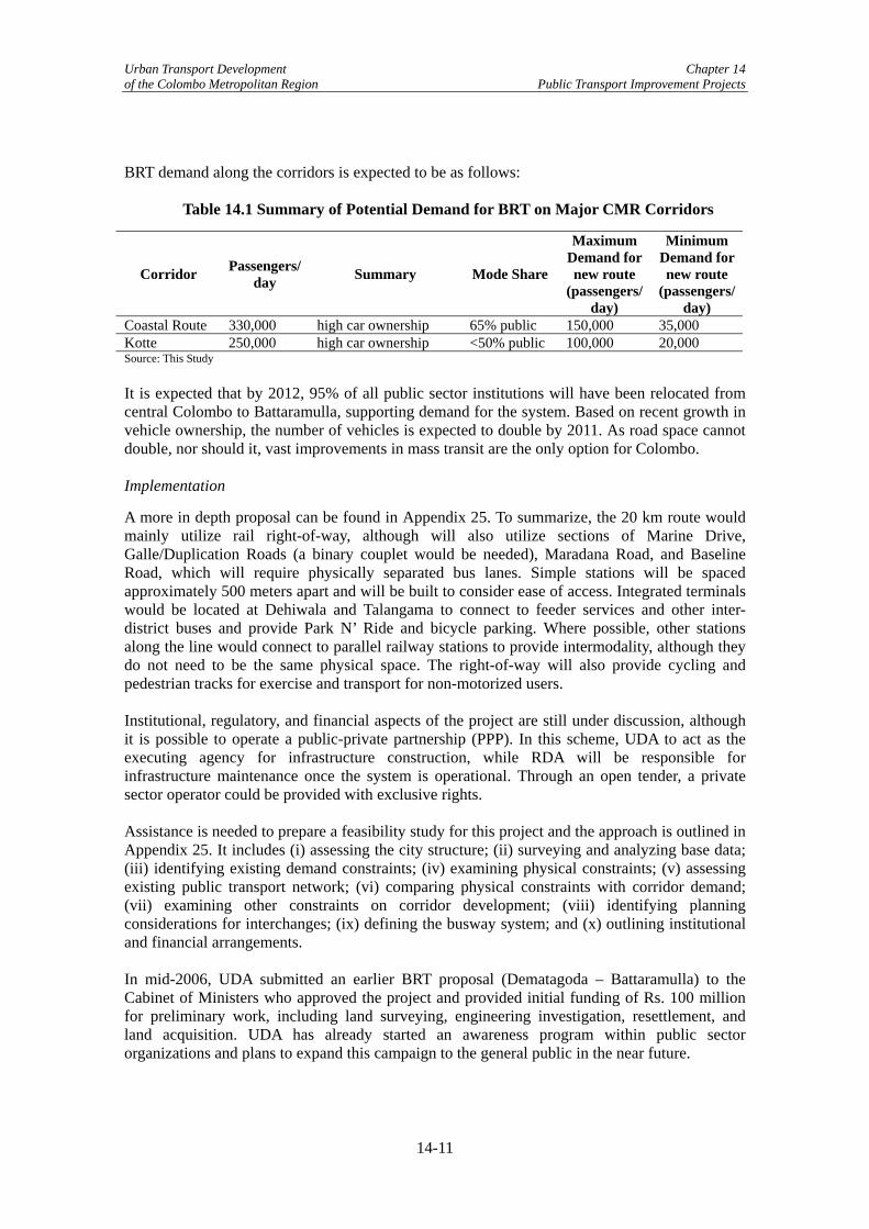
Urban Transport Development Chapter 14 of the Colombo Metropolitan Region Public Transport Improvement Projects
BRT demand along the corridors is expected to be as follows:
Table 14.1 Summary of Potential Demand for BRT on Major CMR Corridors
Corridor Passengers/ day Summary Mode Share
Maximum Demand for new route
(passengers/ day)
Minimum Demand for new route
(passengers/ day)
Coastal Route 330,000 high car ownership 65% public 150,000 35,000 Kotte 250,000 high car ownership <50% public 100,000 20,000 Source: This Study It is expected that by 2012, 95% of all public sector institutions will have been relocated from central Colombo to Battaramulla, supporting demand for the system. Based on recent growth in vehicle ownership, the number of vehicles is expected to double by 2011. As road space cannot double, nor should it, vast improvements in mass transit are the only option for Colombo. Implementation
A more in depth proposal can be found in Appendix 25. To summarize, the 20 km route would mainly utilize rail right-of-way, although will also utilize sections of Marine Drive, Galle/Duplication Roads (a binary couplet would be needed), Maradana Road, and Baseline Road, which will require physically separated bus lanes. Simple stations will be spaced approximately 500 meters apart and will be built to consider ease of access. Integrated terminals would be located at Dehiwala and Talangama to connect to feeder services and other inter-district buses and provide Park N’ Ride and bicycle parking. Where possible, other stations along the line would connect to parallel railway stations to provide intermodality, although they do not need to be the same physical space. The right-of-way will also provide cycling and pedestrian tracks for exercise and transport for non-motorized users. Institutional, regulatory, and financial aspects of the project are still under discussion, although it is possible to operate a public-private partnership (PPP). In this scheme, UDA to act as the executing agency for infrastructure construction, while RDA will be responsible for infrastructure maintenance once the system is operational. Through an open tender, a private sector operator could be provided with exclusive rights. Assistance is needed to prepare a feasibility study for this project and the approach is outlined in Appendix 25. It includes (i) assessing the city structure; (ii) surveying and analyzing base data; (iii) identifying existing demand constraints; (iv) examining physical constraints; (v) assessing existing public transport network; (vi) comparing physical constraints with corridor demand; (vii) examining other constraints on corridor development; (viii) identifying planning considerations for interchanges; (ix) defining the busway system; and (x) outlining institutional and financial arrangements. In mid-2006, UDA submitted an earlier BRT proposal (Dematagoda – Battaramulla) to the Cabinet of Ministers who approved the project and provided initial funding of Rs. 100 million for preliminary work, including land surveying, engineering investigation, resettlement, and land acquisition. UDA has already started an awareness program within public sector organizations and plans to expand this campaign to the general public in the near future.
14-11

Urban Transport Development Chapter 14 of the Colombo Metropolitan Region Public Transport Improvement Projects
Benefits
Faster and More Efficient Commute: As the alignment will be constructed either along exclusive right-of-way or on an exclusive bus lane, the service will provide express service between the terminals and riders will not be subject to road congestion and multiple transfers on low quality public transport, enabling a much faster and higher quality commute. Additionally, as the service is direct, riders will not have to pay the transfer penalties typically found in Colombo due to paying on each bus. Integration with Multiple Modes: The alignment is such that the system with be integrated with other modes such as rail and public/private buses. This will provide peak and off-peak demand, as well as service for non-public employees. Lower Emissions: It has been discussed by UDA to allow the operator to run only liquefied petroleum gas (LPG) vehicles, which will substantially reduce emissions. Regardless, the vehicles will be new and up to current international standards, so in comparison to the current bus fleet, emissions will be substantially lower. Introduction of Concessions to Public Transport in Colombo: By concessioning the service to a private operator, this will provide a good opportunity to educate the public and transport providers (as well as government officials) on the benefits and approach to concessioning. This may pave the way – together with the implementation of the pilot bus concessioning project – for future concessions in regular bus services. Furthering Urban Development for the Kotte Capital City Development Plan: Once completed, the BRT system will provide the much needed infrastructure to sustain Kotte as the administrative capital area for Sri Lanka. This will further promote the capital city development program envisioned in the Capital City Development Plan. Risk Mitigation Measures
Construction Costs: As the alignment has not yet been decided, it is difficult to ascertain the final cost for the BRT system. Some sections would be very inexpensive, such as on Baseline Road and Marine Drive, while others could be very expensive due to resettlement, such as near the lake or on any rail or canal right-of-way. As it is likely that BRT will be implemented under a build-operate-transfer (BOT) scheme; such variability regarding construction cost may reduce the interest of investors. With this knowledge, UDA has proposed bearing the cost of construction themselves, at least for the original Dematagoda – Battaramulla section. Resettlement: During the feasibility study, additional research would be necessary to estimate the number of households that would be affected by this project. If the project were to go ahead using rail right-of-way, the number of households requiring resettlement could be minimized, although there has been extensive encroachment along the KV Line. Land Acquisition: The project recommends making extensive use of rail right-of-way along the Coastal, Main, and Kelani Valley Lines. Sri Lanka Railways currently owns this land, so their approval for this project will be necessary. As they may view this project as competition to the railway, obtaining their approval may not be easy.
14-12

Urban Transport Development Chapter 14 of the Colombo Metropolitan Region Public Transport Improvement Projects
(3) Bus Stop Facility Improvements Bus-8: Develop Bus Stop Facilities on High Demand Corridors Along High Demand Corridors, improve the waiting facilities at bus stops, including the shelters and passenger information and construct useable bus bays.
Project Description
One of the most forgotten aspects of making public transport safe is the provision of adequate bus stop facilities. There are several different types of stops from a simple wide spot in the road to an off street transfer facility. Improving the waiting environment at bus stops through the provision or upgrading of bus stop facilities reinforces pedestrian safety and allows the passenger, or potential passenger, to determine where they can get safely on and off the bus, take shelter from the elements, and better plan their trip. Appropriate facilities for the passengers include benches, information signs, shelters, and trash receptacles
The existing bus stop conditions in Colombo vary. Some have bus shelters, while only bus stop signs are erected in other locations. There are a few stops that have no markings at all, although this is rare. This project will be implemented along the six high demand corridors including Negombo, Kandy, Parliament, A4, Horana, and Galle Road. It will involve the following three components:
• Bus shelter: A new bus shelter design will be developed. Instead of chairs, a steel bar will be provided for waiting passengers to sit for a short time. The width will be the same, but the longitudinal length will vary depending on demand. Bus shelters will have walls to protect waiting passengers from rain. If the sidewalk is too narrow and there is no space for pedestrians to walk behind the shelter, a bus shelter without walls will also be considered.
• Passenger information: Information listing the bus routes that use the bus stop and their final destination will be schematically shown on a signboard to provide guidance to bus passengers. The signboard must be updated if there is any change in bus routing and schedules.
• Bus bay: A new bus bay 1.5m in width, which allows buses to pull out of the main traffic flow, will be constructed to allow other vehicles to proceed while a bus is picking up/dropping off passengers. This will include relocating or reinforcing the existing drainage system and removing the existing curb. While a bus bay minimizes disturbances to traffic flow, it also has some drawbacks including:
- No consideration for pedestrians: The same design is applied regardless of the
sidewalk width, which results in the bus bay taking up a majority of the sidewalk, leaving no space for pedestrians at some locations. As a result, waiting bus passengers stand inside bus bay and pedestrians walk through bus bay.
- Wide bus bay: The existing bus bays have a width of about 3.0m, which can completely accommodate a bus. However, bus drivers tend not to use the whole space. Instead, they leave half the bus in the travel lane, eliminating any benefit of the bay. This is done for two reasons: (i) more effort is required to maneuver the bus completely to the curb in a short distance and (ii) when bus tries to return to the travel lane merging is more difficult.
14-13

Urban Transport Development Chapter 14 of the Colombo Metropolitan Region Public Transport Improvement Projects
- Existence of old curb: Many bus bays seem to have been constructed after original road construction. Therefore, the original curb remains and underground drainage was not relocated. The pavement is not smooth and results in vibrations when crossed.
Benefits of Improving Bus Stop Facilities
• Better bus waiting atmosphere: By improving the waiting area and the bus bays, bus service overall should increase, as many passengers make transfers during their journey. However, the magnitude of benefits is impossible to quantify. It should be considered that bus shelters and guide signs are minimum facilities at bus stops.
Risk Mitigation Measures
• Coordination with SLTB and WPRPTA: The project will be implemented by the Road Development Authority (RDA) and the Colombo Municipal Council (CMC), while bus operation is managed by SLTB and WPRPTA. Thus the close coordination among these institutions is crucial for the smooth implementation of the project.
(4) Institutional Strengthening and Capacity Building: NTC, SLTB, and WPRPTA Previous training has not resulted in long-term benefits, mainly due to the unsustainability of the training and lack of funds of the implementing agencies. It is therefore proposed that capacity building be accomplished through on-the-job training (OJT). This means that international short-term experts and where possible, domestic experts including experts from agencies such as the State Enterprise Management Agency (SEMA) that focused on implementing private sector management processes and practices in the public sector, would focus on specific topics and work with implementing agency counterparts to accomplish a specific goal or project. Therefore, it is envisioned that capacity building should be implemented at all implementing agencies – NTC, SLTB, and WPRPTA – as a basis for implementing the projects, as well as to provide a firm basis for future transport management and operations. There is some overlap between the capacity building projects (i.e. basic information on concessioning), so resources could be shared, although each has its own agency-specific topics. Short-List Projects
The recommended capacity building projects are as follows: Bus-3: Strengthening of NTC on Transport Planning and Operations/Management Using the approach of both sending topical experts to an organization for an extensive period of time and tying capacity building to other projects in order to have concrete objectives, the following topics are proposed for capacity building (i) Develop Regulatory System for Concessioning; (ii) Develop Analytical/Quantitative Skills in form of Surveys and Data Analysis; (iii) Develop Information System; (iv) Develop Costing and Pricing System; (v) Develop Clear Understanding of Concessioning; (vi) Develop Understanding of Route Network Design; and (vii) Create Service Level Improvements (i.e. Timetables). Project Description
Developing institutional capacities in transport planning and administration are often considered a bottleneck for number of countries worldwide. Computerizing data and training staff in
14-14

Urban Transport Development Chapter 14 of the Colombo Metropolitan Region Public Transport Improvement Projects
transport statistics preparation, analysis, and dissemination; and strengthening project management capabilities to effectively implement new transport policies are paramount to NTC’s institutional effectiveness and sustainability. For this project, the consultants will conduct a needs assessment in order to specifically identify the key training topics and to understand what needs to be covered within each one. Next, the consultants will identify the level of staff who will attend the training courses. The training methodology and curriculum will then be developed, both for general education, as well as a more rigorous OJT, including the expected outcomes. Training courses in addition to train-the-trainer programs will be conducted in order to ensure sustainability of knowledge. Repetitive training schedules (possibly every six months) for new hires as well as training schedules for current employees to update their skills will be created. Finally, the consultants will develop a secondment program to provide staff with an opportunity to learn new skills, gain from new experiences, and work in different teams, resulting in a “big picture” view of the organization. The Study Team has identified the key topics below; however, these may be further refined in discussions with the implementing agency.
• Develop Regulatory System for Concessioning: As indicated in Bus-1, the NTC Amendment Act must be modified to allow for and encourage competitive bidding. The regulatory specialist will work with NTC to formulate the appropriate legislation that is clear enough, but also is far reaching.
• Develop Analytical/Quantitative Skills by Conducting Surveys and Analyzing Data: To develop new policies and services, relevant and current data and the capacity to understand and present the data is essential. Currently, little of the data is computerized and the capacity to utilize the data is limited. This portion of capacity building would work with staff to identify necessary data, create surveys, implement surveys, computerize and input the data into a database, and analyze the resulting data.
• Develop Information System: Once the quantitative skills are improved and conducting surveys and analyzing data is possible, an information system will be needed to ensure access to the data, as well as ensure its authenticity. This will also provide historical data to show trends. All should assist in combating external influences.
• Develop Costing and Pricing System: As the main organization for the island-wide bus sector, it is necessary that costing and pricing of bus transport is clearly understood and documented.
• Develop Clear Understanding of Concessioning: With a policy shift towards concessioning, significant education of all bus sector organizations will have to be undertaken to lessen the negativity surrounding the policy.
• Develop Understanding of Route Network Design: As part of Bus-1, the route network is expected to be rationalized. Although urban bus routes are the responsibility of WPRPTA, capacity is limited and NTC will be expected to assist. Therefore, a clear understanding of Route Network Design, including the software used, will be the focus of this training.
• Create Service Level Improvements (i.e. Timetables): In reference to the development to timetables in Bus-2 below, further assistance will be given to increase the intermodal focus of timetable development, as currently, timetables are developed individually, without consideration of other modes or other bus routes.
14-15

Urban Transport Development Chapter 14 of the Colombo Metropolitan Region Public Transport Improvement Projects
Bus-4: Strengthening of SLTB on Operations/Management Using the approach of both sending topical experts to an organization for an extensive period of time and tying capacity building to other projects in order to have concrete objectives, the following topics are proposed for capacity building: (i) Develop Strategy (Short, Medium, and Long-Term) Strategy; (ii) Developing Marketing Plan; (iii) Develop Costing System; (iv) Develop Analytical/Quantitative Skills in form of Surveys and Data Analysis; (v) Develop Crew and Vehicle Assignment and Maintenance Methodology/Skills; (vi) Develop Clear Understanding of Concessioning; (vii) Development of Human Resources Management; and (viii) Modernize Crew Training. Project Description
Operations management involves the responsibility of ensuring that transport operations are efficient and effective. It also involves the management of resources and the distribution of services to customers. The Study Team noted the need for the SLTB to focus on the effective planning, scheduling, use and control of their resources. A training program, similar to the one summarized in Bus-3, will be implemented in this project through a variety of topics outlined below:
• Develop Short, Medium, and Long-Term Strategy: Although perhaps too large to undertake completely through capacity building, SLTB needs to clarify and work towards implementing a clear strategy for improving their services and standing in the sector. This is especially relevant with the implementation of concessioning, competition for the route will be the standard, as well as creating exclusive routes (as opposed to shared routes).
• Develop Marketing Plan: Along with a strategy, a marketing plan should be created to advertise changes to SLTB and let riders know what they can expect. Marketing could also be used to discuss potential changes with politicians and other decision-makers.
• Develop Costing System: Although in its preamble, the SLTB Act #27 (2005) requires cost effective transport services, the government appears to have created a policy that SLTB does not need to implement fare increases. Therefore, it is necessary to develop a clear method of costing operations and assets in order to ensure that SLTB receives sufficient government subsidies (since costs are not recovered at the farebox) to ensure safe and effective operations, while also performing necessary maintenance.
• Develop Crew and Vehicle Assignment and Maintenance Methodology/Skills: To make the organization more efficient, a more standardized methodology for crew and vehicle assignment, as well as vehicle maintenance should be created and implemented.
• Develop Human Resources Management: The main focus is to improve general management skills with a focus on human resources management.
• Modernize Crew Training: Crew training needs to be upgraded (i.e. current methods include the use of hand signals), so this section of the training will review the current training methods and make modifications and improvements to bring the topics and training to a modern level.
14-16
Urban Transport Development Chapter 14 of the Colombo Metropolitan Region Public Transport Improvement Projects
Bus-5: Develop a Training Center at Western Province Road Passenger Transport Authority and Undertake Strengthening of WPRPTA (Transport Planning and Operations/Management), Private Bus Owners/Operators (Operations/Management), and Crew (Discipline, Road Rules, Operations)16
Using the approach of both sending topical experts to an organization for an extensive period of time and tying capacity building to other projects in order to have concrete objectives, the following measures are proposed for capacity building: Strengthening of WPRPTA Staff: (i) Develop and institutionalize Human Resources Management; (ii) Develop Clear Understanding of Concessioning; (iii) Develop Analytical/Quantitative Skills in form of Surveys and Data Analysis; (iv) Develop an Information System; (v) Develop a Marketing Plan; (vi) Incorporate Intermodalism, including Intermodal Centers (once developed); (vii) Develop Understanding of Route Network Design; and (vii) Create Service Level Improvements (i.e. Timetables). Strengthening of Private Bus Owners/Operators: Training sessions and general workshops should be provided during the specialists’ tenures that focus on the benefits of concessioning, route rationalization, and timetabling, as well as the basic methodology behind it (to demonstrate transparency). Additional assistance can be provided in corporatization during concessioning. Strengthening of Private Bus Crews17: WPRPTA would like to improve on NTC’s training to provide longer training sessions, as well as create a database system to record crew members who have successfully completed the training course(s), as this will be necessary for concessioning. Project Description
WPRPTA has put forth a proposal to develop a training center to train bus crews, similar to what is done at SLTB. Only bus crews that pass the training are eligible to be drivers/conductors on private buses operating in WP. The Study Team believes that this training center should be expanded to include training facilities for WPRPTA staff and private bus owners/operators. For this project, the consultants will select and obtain the premises for the Crew Training School (WPRTPA has selected a site at the Malabe Bus Station, which is owned by WPRPTA). Next, the consultants will recruit crew trainers and assign staff to operate the training school. Following the identification of training topics, the consultants will identify training course attendees, develop training materials and purchase training equipment. Finally, after market training activities for private bus owners/operators and private bus crew are provided, training courses will be conducted in correspondence to the creation of a database of crews, owner/operators, and WPRPTA staff to record classes successfully completed. Using a training program, similar to that which was outlined in Bus-3 and Bus-4, this project will specifically concentrate on the following points to build the capacity of WPRPTA staff:
• Strengthening of Private Bus Owners/Operators: When the consultants are undertaking training of WPRPTA staff on concessioning, route rationalization, and timetabling, the private owners and operators should be invited to attend the workshops and sessions as
16 Note that this project is meant to be combined with 3W-1. 17 Note that NTC is already undertaking some of this training, so it would be worthwhile to first work with NTC to extend the training.
14-17
Urban Transport Development Chapter 14 of the Colombo Metropolitan Region Public Transport Improvement Projects
well. Alternatively, workshops and sessions can be given specifically to the private owners and operators to educate them on the benefits (and risks) of the different proposals. Additional assistance can be provided in corporatization during concessioning. This relates strongly to Bus-1 and Bus-2.
• Strengthening of Private Bus Crews: Although NTC is currently undertaking a two-day training program for private crews, WPRPTA would like expand that to provide longer training sessions, with in-vehicle training. This would require the purchase or rental of two buses. Passing crews will be kept in a database so that once concessioning is implemented, operators will be able to hire trained crews.
Benefits of Capacity Building
• Engender Long-term Career Development: The capacity building undertaken above is not simply limited to training, but is expansive enough to cover almost a year of career development for each specialist, such that on-the-job training can occur and the Sri Lankan counterparts can learn and become accustomed to new methodologies in specific areas and actually implement them. This is critical to making real long-term changes in the continued learning capacities of staff.
• Establish Linkages with Other Projects: The majority of capacity building topics are tied directly to other projects, such that there are parallel projects with funding and implementation deadlines. This provides incentives to increase capacity and actually learn the processes and practices for implementation.
• Increase the Likelihood of Success: Many previously conducted capacity building projects have been short-term in focus, whereby specialists come for a few weeks, give a training session and leave, which has reduced the potential for learning. The estimated year-long commitment of most of the specialists helps to increase the likelihood of success.
Risk Mitigation Measures of Capacity Building
Even in projects as theoretically inexpensive and easily justifiable as capacity building, there are risks. Approaches to mitigate the potentials risks associated with capacity building projects include the following:
• Increase Long-term Sustainability of Capacity Building (All): While specialist are
welcome at the implementing agencies, when the agencies were asked to identify a long-term sustainable strategy, they indicated that there will likely be insufficient funds and time to continue the training after the experts leave. This can be minimized by keeping experts in Colombo for a year or so, working with local professionals OJT and targeting the training on specific qualified individuals in each organization. Any resulting documentation should be translated into Sinhala and Tamil to increase the likelihood of future use. In this case, a space to store the manuals, as well as a simple database of manuals and presentations should be created to ensure use.
• Increase Interest in Capacity Building by Bureaucrats (All): Officials have indicated a lack of interest by many bureaucrats in increasing their knowledge regarding transport, as many do not have the educational background for more than basic information. This risk can be mitigated by targeting detailed training at transport professionals in the organization, as well as new graduates, while also providing basic transport knowledge to the others.
• Provide Incentives for Private Crew To Participate in Training (Bus-5): 1-2 day training has been undertaken recently for private crew. However, participants must pay for the class, missing a few days of income, while benefiting little, as there are no laws
14-18

Urban Transport Development Chapter 14 of the Colombo Metropolitan Region Public Transport Improvement Projects
that require training for crew. Therefore, there are few incentives to participate in another training session.
• Varying Levels of Education and Knowledge (Bus-5): In the private bus sector, some operators are highly knowledgeable on bus operations and strategies, while others simply own a bus and have little idea as to the complexities of the sector. Any training to the operators will need to vary in content to be applicable to both.
14.3 Intermodal Improvement Projects Based on discussions with the PTWG, RDPWG, and the TMSWG, the following improvement projects were identified to improve intermodalism. (1) Increasing Inter- and Intramodal Coordination among Buses and between Bus and
Rail Intermodalism was discussed at length in the Working Groups, as well as identified as a major goal necessary to promote public transport use. Intermodalism implies that modes are approached collectively, not as individual modes and includes planning, service, timetables, ticketing, and fares. Each of these aspects of intermodalism was addressed by the PTWG. However, it was determined that timetabling was the only feasible aspect that could be effectively addressed, due to the timeframe allotted for this study.18 Short-List Project
Bus-2: Project to Increase Intermodal and Intramodal Coordination by Timetable Creation, Implementation and Enforcement This project will create and implement timetables for both privately operated and jointly operated routes, with a focus on high demand corridors such as Galle, Baseline, and High Level Roads and those routes that have many transfers with SLR. This will require extensive work with the route associations, as implementation is their responsibility. It is expected that WPRPTA, the main implementing agency, will also work with route associations to outline an implementation and enforcement plan to help reduce the interference from the informal sector who operate in many private bus terminals. The implementation plan will also include the distribution of the timetables (at stations, in the newspapers, and online if possible).
Project Description
A good timetable lays the foundation for successful public transport. The availability, cost and frequency of services and information as to how passengers can connect is essential for a journey to be made on time and with the maximum convenience. Difficulty in finding out what time services run can discourage people from traveling by bus and will make travel by car seem more reliable, attractive and convenient. According to WPRPTA, there are now 50 rotating timetables in operation in WP. As explained in Chapter 7, the rotating of timetables helps to ensure that time and profits are spread across all operators on the route. However, these timetables have been created for a single route and do not take into account other routes on the same corridors or those that stop at rail stations or major bus stations. Bus-2 is planned to incorporate the inter- and intramodal aspects of timetabling, as well as to reduce the bunches of buses that constantly operate on each corridor. 18 It is worth noting that many developed cities do not have integrated ticketing and fares among buses and trains – owing to the complexities of such a project.
14-19

Urban Transport Development Chapter 14 of the Colombo Metropolitan Region Public Transport Improvement Projects
Groups of routes should be identified to be timetabled together, most likely with a focus on the high demand corridors and the surrounding routes, to help reduce congestion due to buses on the corridors. For each route, surveys will need to be conducted to identify the length of the route and travel time each way during the peak and off-peak. Additionally, a loading survey will need to be conducted for each route to ensure that frequencies meet demand. Sri Lanka Railways (SLR) will also need to supply the train timetables, along with an estimate of actual arrival times, taking into account knowledge of delays.19 Intermodal timetables, which include bus-bus transfers, require more technical solutions that currently being used by NTC and WPRPTA. Therefore, this project would utilize timetabling software as well as provide training. The output of this training would be an initial set of rotated timetables for the first group of routes that ensures demand and intra- and intermodal transfers are met. While the timetables are being created, the bus operations specialist will work with WPRPTA, SLTB, and NTC to create a feasible rollout plan, including the creation of printed timetables that can be provided to riders and posted at all major stops and stations. The implementation plan should include a marketing campaign to contest the potential negative reaction from the private and informal sector. The marketing campaign should also focus on the general public to educate them on the changes, as well as how to provide feedback if the operators are not operating on schedule. The private sector and SLTB should be consulted during timetable creation based on their knowledge and the increased possibility of implementation. Additionally, while creating the implementation plan, enforcement and monitoring plans should also be created so that WPRPTA and NTC will know how well the timetables are working and if they need to be modified.20
Benefits
• Implement Operational Changes – First Step to Concessions: A central benefit to encourage route associations is to implement operational changes as an organization, instead of as individual operators, as well as encourage bus crews to reduce competition among other crews in their association. Obviously, this should positively impact safety, but from a longer-term perspective, it will provide a small start towards changing the private sector mindset, which is necessary to implement concessions.
• Increase Demand Responsiveness: Scheduled bus service will assist passengers in planning their daily trips, as well as reduce their travel times (as waiting time and dwell time should be reduced).
• Increase Safety: Enforcement of timetables will reduce the tendency of crews to race to the next stop to acquire greater revenues.
• Reduce the Need of Riders to Move Between Stations in Search of the Next Departure: This is particularly common in Pettah on dual operated routes, whereby passengers traverse the bus stands in search of the next scheduled departure, adding stress and time to their trip. As the schedule for private and SLTB buses would be posted at both stands, riders would know whether to walk to the other stand or simply wait for the next bus at the current stand.
• Facilitate Bus-Rail Interchange: Provide better complete journeys for riders transferring between bus and rail or between different bus routes, which will result in a time-savings for passengers.
19 Note that SLR timetables can be modified as well, although it is easier to modify bus timetables, than SLR since SLR lines also include long-distance trains. 20 This would require SLTB to allow WPRPTA officials to monitor SLTB routes within SLTB terminals.
14-20

Urban Transport Development Chapter 14 of the Colombo Metropolitan Region Public Transport Improvement Projects
• Reduce Excess Buses on High Demand Corridors: 40.6% of operational routes have more buses operating than are needed.21 Timetables would shift excess buses to standby positions, reducing the number of buses on the road. As the supply is based on the demand survey, demand should still be met.
• Require Early Morning and Late Night Service: Timetables would be created based on a full operating schedule, including early morning and late night services.
Risk Mitigation Measures
• Improve Trust Between and Among SLTB, Private Operators, and Government: In the current environment, there is distrust among the organizations, due to the protection given to SLTB, as viewed by the private sector. Overcoming this will be a gradual process.
• Clarify Role of SLTB: For dual operated routes, the timetables will be created based on current market share. However, the central government wants to increase SLTB’s market share to 40% on the routes that they operate with the private sector. Like concessioning above, this protectionist issue will need to be clarified prior to implementation of the timetables, otherwise distrust among SLTB, private operators, and the government will continue to be an issue.
• Strengthen Monitoring and Enforcement Capabilities: Timekeepers, who are the current mechanisms of monitoring and enforcement and are stationed at various terminals, are highly vulnerable to external influences. New mechanisms of monitoring and enforcement are needed to combat external influences.
• Modify View of SLR that Buses are Competition: SLR continues to view buses as competition, as opposed to a complementary mode of transport that can provide them with additional passengers. Continuing this mindset will reduce the compatibility of the timetables.
• Reduce Strength of Informal Sector: As indicated in Bus-1, the informal sector is very strong at some of the bus stations and they currently earn money based on the lack of a timetable. Therefore, the implementation of such timetables will likely meet with strong resistance.
(2) Intermodal Transport Centers Short-List Project
Road-49 and Road 50: Develop Intermodal Transport Center [Suburban and CMC Areas] Construct Intermodal Transport Centers at Moratuwa, Kottawa, and Ragama (Suburban) and Dematogoda, Borella, and Narahenpita (CMC) to promote a modal shift from road-based modes to rail-based modes and encourage the use of mass transit.22 Project Description
One of the challenges of intermodal transport is changing between modes. Despite proximity, transfers can be difficult. To encourage ease of transfer between modes, Intermodal Transport Centers have been developed. In the case of Colombo, two primary issues have precluded the development of ITCs. The first is the clear lack of policy coordination by the government and 21 Calculations based on WPRPTA and NTC data 22 Depending on the alignment of the BRT corridors, the ITC locations should be changed to provide intermodal connections between buses, rail, and BRT.
14-21

Urban Transport Development Chapter 14 of the Colombo Metropolitan Region Public Transport Improvement Projects
the second is the negative public opinion of ITCs, which stems from the historic development of markets (by which people have built their livelihoods) surrounding Colombo’s concentric system. In the CMR, road-based modes of transport carry 90% of all passenger traffic. The purpose of an ITC is to: (i) promote modal shift from road-based passenger transport modes to rail-based passenger transport modes; (ii) facilitate transfers between modes; and (iii) encourage private passenger road vehicle users to ride mass transit. Note that it is proposed that ITCs be developed under a combined initiative of the public and private sectors, with underutilized space around railway stations to be initially used to provide park ‘n’ ride and kiss ‘n’ ride facilities, taxi stands, and bicycle/motorcycle parking facilities. To promote the above, three ITCs in the suburban locations of Moratuwa, Kottawa, and Ragama have been selected to create a multi-modal system for a polycentric CMR. In addition, three urban ITCs have been proposed to be located in Dematogoda, Borella, and Narahenpita. As there is a lack of connection between bus and rail, as well between mainline buses and feeder buses, three wheelers, taxis and private cars in the urban area, the purpose of these ITCs is to promote the integration of these services. Institutional weaknesses, poor access between road and rail, and the problems of coordination of operation among modes are risks for the implementation of this project. Note that the Study Team is of the opinion that unless the KV Rail Line is improved, the ITCs at Borella and Narahenpita should not be constructed, as the number of users on this line is small due to low frequency of operation and slow operation speeds. 14.4 Rail Improvement Projects Further to the PTWG evaluation of the Long List of Projects, the following rail sector improvement projects were short-listed (See Section 11.2 for evaluation criteria). While there are only three measures listed in this section, Bus-2, Road-49, and Road-50 also involve the railway through improvements in intermodalism, both in service and in infrastructure. Because of the substantial institutional issues that have been identified, implementing most rail projects will be extremely difficult as political will to make any changes to the current organizational and management structure is lacking. Therefore, the PTWG believed that the best way forward was to encourage intermodalism between bus and rail or between rail and private automobiles. With the impending delivery of 15 additional diesel multiple units (1 DMU = 5 carriages and 2 engines) to be used for Colombo suburban services, it was felt that the best way forward was to increase the capacity and speeds of the existing railway, as opposed to building new infrastructure. This was felt to hold the best option for the railway to play a larger role in alleviating traffic congestion. (1) Rehabilitation of Rail Siding and Rail Facilities In the late 1990s, the main tracks were rehabilitated by the Overseas Economic Cooperation Fund (OECF, now JBIC). SLR created a request for a second phase of work in 2000. This phase includes the rehabilitation of the rail siding and rail facilities of Sri Lanka Railways, within the CMR. It includes the Coastal Line from Fort – Kalutara, the Main Line from Fort – Ragama, the Puttlam Line from Ragama – Negombo, and the Kelani Valley (KV) Line from Fort – Homagama.
14-22
Urban Transport Development Chapter 14 of the Colombo Metropolitan Region Public Transport Improvement Projects
Short-List Project
From conclusions drawn during the Long List of Projects prioritization process, the Study Team recommends the following project: Rail-1: Rehabilitation of Rail Siding and Rail Facilities A CMR track rehabilitation project was completed during 1996-99, but the project did not include siding tracks and rail facilities. Work on this project would include the Main, Coastal, KV, and Puttlam Lines with a focus on (i) improving station yards, (ii) providing drainage where necessary, (iii) widening cess23 to provide shoulder ballast, (iv) welding rails between stations by introducing glued joints, (v) improving triple track with new BS 90A rails, concrete sleepers,24 ballast and drainage, and (vi) providing all turnouts with concrete sleepers and weld the turnouts. Project Description
The need for preventive and corrective measures in rehabilitating railways depends on the severity and nature of adverse effects and the costs of prevention and remedy. The rail sector in the CRM has suffered from insufficient investment over the past twenty to thirty years, which has led to a severe reduction in regular maintenance and postponement of facility upgrades as well as reduced safety and reliability. The project described below outlines the proposed corrective measures as well as their risks and corresponding mitigation measures. A Report on Improvement of Track and Transport in the Next Stage (i.e. Phase II) was created by SLR in March 2000 and submitted for financing.25 The first phase was funded by JBIC and tasked with rehabilitating the main travel tracks along the Main, Coastal, and Puttlam Lines. The donors declined to finance the second phase of the project and since SLR has limited funds, facilities have continued to decline. It is recommended that this document be thoroughly reviewed, as the below information only provides a general overview of the project. Additionally, as the information in the report is at least six years old, it should be updated prior to requesting funds. Although the railway lines described below stretch beyond the Outer Circular Highway, the stations below are considered to incorporate the Colombo suburban area from SLR’s perspective. Specific project work is laid out as follows:
• Main Line (Fort-Ragama): Rehabilitate the third line track. Station yards would be rehabilitated to increase the capacity of rolling stock and other rail storage. Drainage facilities need to be improved where necessary. Widen the area on either side of the railway (cess) to provide for a ballast shoulder. Weld the rails between stations to include glued joints. According to the March 2000 document, this would allow speeds to increase to 100 kmph.
• Coastal Line (Dematagoda-Maradana): All three tracks need to be rehabilitated with BS 90A rails, concrete sleepers, ballast, and drainage. All turnouts should be provided with concrete sleepers and welded.
• Coastal Line (Fort-Kalutara): Station yards would be rehabilitated to increase the capacity of rolling stock and other rail storage. Drainage facilities need to be improved where necessary. Widen the area on either side of the railway (cess) to provide for a ballast shoulder. Weld the rails between stations to include glued joints. Due to the
23 The area either side of the railway immediately off the ballast shoulder 24 A concrete object which holds the rails to the correct track gauge and supports the track on the ballast 25 Copy of report obtained directly from SLR. Note that the report includes rehabilitation of track beyond the stations indicated in this project sheet.
14-23

Urban Transport Development Chapter 14 of the Colombo Metropolitan Region Public Transport Improvement Projects
line’s proximity to the sea, 5-10 rail panels should be provided in the areas that are likely to be highly corrosive. According to the March 2000 document, this would allow speeds to increase to 100 kmph.
• KV Line (Fort-Homagama): This line was widened from narrow to broad gauge between 1991-97, but funds did not provide for a full overhaul of the line such as (i) widening and strengthening embankments, (ii) bridge abutments, (iii) replacing bridges where necessary, and (iv) straightening the line, as it is has tight curves in some parts. As discussed by the PTWG, straightening the KV Line is beyond the timeline of this project because of the large amount of land acquisition necessary. Land acquisition also prohibits adding a second track to the line. However, since the KV Line does have the potential to alleviate traffic along Baseline and High Level Roads, it should be rehabilitated to maximize the facilities currently in place. At this time the permissible speeds are restricted to 32 kmph and coupled with the single track, insufficient capacity is provided. This project then would rehabilitate the track with BS 90A rails, welded where possible and concrete and wooden sleepers, completely ballasted. 26 Where possible, widen and strengthen embankments and bridge abutments. At level crossings, improvements should be made both from a safety perspective, as well as to allow for viable speeds. It is estimated that these changes could increase speeds to 60-70 kmph.
• Puttlam Line (Ragama-Negombo): Station yards would be rehabilitated to increase the capacity of rolling stock and other rail storage. Drainage facilities need to be improved where necessary. Widen the area on either side of the railway (cess) to provide for a ballast shoulder. Weld the rails between stations to include glued joints. According to the March 2000 document, this would allow speeds to increase to 100 kmph.
Benefits
• Increase Safety: By improving the drainage facilities, as well as the ballast and cess, it is expected that safety should increase, as the current structures are old or have been damaged by environmental elements.
• Increase Speeds: As indicated above, speeds along the railway should be able to increase following the improvements to the railway structures.
• Improve Rail Facilities: As this study is focused on reducing traffic congestion, the most feasible mode to bring about a change is the railway. Therefore, any improvements that can be made to the railway and will have a quantifiable positive impact should be undertaken.
Risk Mitigation Measures
• Improve Maintenance System: It is unlikely that a proper maintenance system exists to undertake the necessary maintenance on the rehabilitated structures, which would impact the longevity of this investment.
• Understand Costs to Ensure Consistent Subsidies for Maintenance: As can be seen by the lack of maintenance currently undertaken by SLR, funding for maintenance is arbitrary year-to-year and, on the whole, insufficient. If a clearer costing system is not developed, as well as an agreement between SLR and the government to provide sufficient funds for maintenance, the rehabilitated sections will decline.
• Limit Impact: As, except for the KV Line, this project rehabilitates/improves rail facilities, not the main track, the actual benefits to improving rail travel and impacting traffic congestion are unclear.
26 Wooden sleepers would be used on sharp curves where check rails are provided.
14-24

Urban Transport Development Chapter 14 of the Colombo Metropolitan Region Public Transport Improvement Projects
• Resettle Citizens along KV Line: Along the KV Line, there has been heavy residential encroachment along approximately 50% of the line between Fort and Homagama, which will need to be resolved prior to improving that line. However, it is only resettlement, not land acquisition, as the land already belongs to SLR.
(2) Rehabilitating Rail Signaling and Communications System Like Rail-1 above, the 1996-99 rail rehabilitation project did not address SLR’s signaling and communications systems. Short-List Project
From conclusions drawn during the prioritization process, the Study Team recommends the following project: Rail-2: Rehabilitation of Rail Signaling and Communications System A CMR track rehabilitation project was completed during 1996-99, but the project did not include the signaling and communications systems. The current signaling system is over 40 years old and spare parts are no longer available. This is seriously impacting both the safety and the capacity of the railway, as trains must be spaced further apart to reduce the likelihood of accidents. The project includes: (i) implementing an up-to-date telecommunications system for SLR within the Colombo suburban area and (ii) improving the signaling system. Project Description
Railway signaling and communications systems play pivotal roles in railway operations as they are crucial in controlling traffic safely, for example, to prevent trains from colliding. As indicated in Rail-1, the sector suffers from insufficient investment that impacts the current signaling and telecommunications system, described as follows:
• Signaling System (Main, Puttlam, Coastal Lines as per the stations listed in Rail-1): The station and block signaling systems were installed in 1962.27 The station signaling system includes color light signaling with color lights, motor operated points, and relay interlocking. The block signaling system includes automatic block signaling, as well as color light signals every 2-3 km. All of the equipment for these systems, including relays, point machine signals, and cables are over 40 years old. Additionally, there is a Centralized Traffic Control Center (CTC) in Maradana, which was developed in 1985. Spare parts have been unavailable since 1991 and failures are common due to aging parts.
• Signaling System (KV Line as per the stations listed in Rail-1): The station and block signaling systems were installed between 1995 and 2000. The system consists of uninterlocked C type signaling with color light signals operated by station masters through local panels. The block signaling system is a tablet token block system, a system that is dependent on a device carried by the driver. According to SLR, this system is not suitable for this section of the KV Line and will not provide a safe, reliable, and efficient train service.
27 Station signaling: Deals with arriving and departing trains at a station yard and can be operated locally (at the station) or centrally (at a centralized control center). Block signaling: Controls the movement of trains between station yards
14-25

Urban Transport Development Chapter 14 of the Colombo Metropolitan Region Public Transport Improvement Projects
• Telecommunications System (Suburban Area): The current suburban system allows train controllers to communicate with station masters or train drivers using a common two-wire multi-drop telephone system, which, while easy to operate, is unsafe as all station masters and drivers can hear all instructions from the controllers. This leads to confusion, is outdated, and lacks spare parts. In the outer CMC area, there are 17 radio repeater stations and about 120 fixed radios. The train controller and station master can speak directly to each other through a dedicated system, which again, is convenient, but is outdated, spare parts are lacking, and train drivers do not have radio telephones.
Proposed Improvements
• Signaling System: The purpose of the signaling system is to ensure the safety of the trains in operation, as well as to improve their efficiency. There are two proposals to improve the signaling system. The first is to install a new CTC that would cover the suburban area (as outlined in Rail-1), replace the 40-year old interlocking system including external equipment and block signaling on the Main, Coastal, and Puttlam lines, and replace the signaling system on the KV line. The second proposal would be to simply install a new CTC that would cover the suburban area and replace the signaling system of the KV Line. The costs are outlined in the project sheet in Appendix 20. The signaling system can be improved within the suburban area alone, without improving the rest of the network (although this is recommended in the near future).
• Telecommunications System: The purpose of the telecommunications system is to provide safe and reliable data and voice communications for train operations and general administration. The proposal to improve the telecommunications system is as follows: (i) Optical fiber telecommunications backbone network with high capacity SDH transmission (digital); (ii) Transmission system of optical fiber network and private telecommunications network transmission system; (iii) 1 switch at Colombo for interconnecting; (iv) 102 telephones for train controlling and level crossings; (v) 150 telephones for general administration and maintenance; and (vi) Digital Radio telecommunications network based on CDMA or TDMA technology with fixed radios in locomotives and mobile radios for staff officers, maintenance staff, and shunting staff having 290 mobile units and 5 base units. The costs are outlined in the project sheet in Appendix 20. It is recommended that the telecommunications system be upgraded throughout the entire SLR network, as only improving the suburban area may lead to confusion and miscommunication, reducing the safety and efficiency of the system.
Benefits
• Improve Rail Safety: Upgrading the signaling and telecommunications system to current technology, as opposed to 20-40 year old technology, would vastly improve rail safety.
• Improve Rail Capacity: Combined with the rehabilitation done in the late 1990s by JBIC and the rehabilitation undertaken in Rail-1, improving the telecommunications and signaling system would bring about large increases in capacity, as either speeds could be increased or more trains could be in operation with less headway.
Risk Mitigation Measures
• First Step for Full Network Rehabilitation: Both signaling and telecommunications affect the entire network. Because the lines in the Colombo suburban area are shared with long-distance trains, the entire network’s telecommunications and signaling system should be modified, especially the former, so as to reduce the likelihood of confusion.
14-26

Urban Transport Development Chapter 14 of the Colombo Metropolitan Region Public Transport Improvement Projects
This is more important for the telecommunications system, than the signaling system, but does apply to both.
Additionally, the improvement of the maintenance system and understanding costs to ensure funds that were identified above are also relevant for this project. (3) Institutional Strengthening and Capacity Building: SLR Short-List Project
From discussions during the prioritization process, the Study Team identifies the following capacity building project: Rail-3: Strengthening of SLR on Management and Operations and Development of a Strategic Business Unit to Implement Pilot Projects Using the two approaches of sending topical experts to an organization for an extensive period of time and tying capacity building to other projects in order to have concrete objectives, the following topics are proposed for capacity building: (i) Develop Costing System; (ii) Create Operational Improvements (i.e. Timetables); (iii) Improve Use of Intermodal Centers (once developed); (iv) Develop Maintenance Plan for Rehabilitated Rail (Rail-1 and Rail-2); (v) Improve Data Collection and Analysis Skills and Develop an Information System; and (vi) Develop Human Resources Management. Project Description
As indicated in the Bus Capacity Building project summaries, single training has not produced long-term benefits, due to lack of SLR funds. Therefore, this capacity building will implemented through on-the-job training (OJT). For this project, the consultants will identify the management team and structure for the training center as well as the key training topics. Next, the consultants will identify the level of staff who will attend the training courses. The training materials will then be developed and training courses in addition to train-the-trainer programs will be conducted in order to ensure sustainability of knowledge. Repetitive training schedules (possibly every six months) for new hires as well as training schedules for current employees to update their skills will be created. The consultants will also develop a Strategic Business Unit and schedule of task for implementation. Finally, the consultants will create a sustainable training program with Indian Railways through training at their Railway College and by working closely with an Indian counterpart for one to three months. Not only will this allow SLR staff to gain new experiences, and work in different teams, but it will also result in a “big picture” view of the rail sector. The Study Team has identified the topics below; however, these may be further refined in discussions with the implementing agency:
• Develop a SLR Costing System: SLR indicated a need for a fare policy; however, the government, including the President in the Mahindra Chinthanaya appears to feel that rail should operate for the social good and therefore, fares should be kept low. Accepting this policy, SLR should develop a clear understanding of the operating and maintenance costs,28 such that a clear case of costs can be made to the Treasury to
28 Assuming that procurement and rehabilitation will be handled by international loans for the foreseeable future
14-27

Urban Transport Development Chapter 14 of the Colombo Metropolitan Region Public Transport Improvement Projects
ensure that annual subsidies are provided that enable safe and effective operations and maintenance of the system. This will tie directly to Rail-1 and Rail-2 as knowledge of the costs and the ability to articulate subsidy needs will help to ensure that funding will be available to maintain the rehabilitated systems and facilities.
• Create Operational Improvements: This will initially focus on timetable development, since that directly ties to Bus-2, but depending on the outcome of the needs assessment could be expanded.
• Improve Use of Intermodal Centers (once developed): Intermodalism is not viewed positively by SLR, as it is seen as a way to possibly lose passengers, as opposed to a method for improving ridership. However, with the proposed intermodal centers, capacity building needs to be conducted to educate SLR management on the benefits of intermodalism. This should improve the likelihood of success for the intermodal centers.
• Develop Maintenance Plan for Rehabilitated Rail Facilities and Systems: In conjunction with projects Rail-1 and Rail-2, a maintenance plan should be developed to ensure that the rehabilitated facilities and systems are maintained. The plan will include both a maintenance schedule (preventative, overhauls), as well as a costing system (such as described above).
• Improve Data Collection and Analysis Skills and Develop an Information System: To develop new policies and services, relevant and current data and the ability to make a case with the data is essential. This portion of capacity building would work with staff to learn what types of data is necessary, creating surveys, implementing surveys, and computerizing and analyzing the resulting data. Once the quantitative skills are improved and conducting surveys and analyzing data is possible, an information system will be needed to ensure access to the data, as well as ensure its authenticity. It will also ensure that there is historical data, which can show trends. All should assist in combating external influences.
• Develop Human Resources Management: The main focus is to improve general management skills with a focus on human resources management.
Benefits
The benefits have been outlined above in the Bus Sector Capacity Building Projects. Risk Mitigation Measures
Involve Trade Unions: Trade unions are very powerful at SLR and there could be some issues surrounding their willingness to participate in the above capacity building. Additional risks have been outlined above in the Bus Sector Capacity Building Projects. 14.5 Three-Wheeler Improvement Projects As derived from the PTWG evaluation of the Long List of Projects, the following three-wheeler improvement projects were short-listed (See Section 11.2 for evaluation criteria). (1) Institutional Strengthening and Capacity Building: WPRPTA As indicated in Chapter 7, the Three-Wheeler Act was passed by the Western Provincial Council (WPC) in 2002, but its implementation was suspended due to pressures from the three-wheeler (3W) drivers.
14-28
Urban Transport Development Chapter 14 of the Colombo Metropolitan Region Public Transport Improvement Projects
Short-List Project
Based on discussions in the PTWG and with WPRPTA, the Study Team recommends the following capacity building project: 3W-1: Strengthen the WPRPTA to Implement and Strengthen the Three-Wheeler Services Bureau and Outline Three-Wheeler Regulations Using the two approaches of sending topical experts to an organization for an extensive period of time and tying capacity building to other projects in order to have concrete objectives, the following topics are proposed for capacity building: (i) Develop Marketing System; (ii) Develop Regulatory System (only necessary if current act needs to be re-written); (iii) Develop General Management Knowledge; (iv) Develop Analytical/Quantitative Skills in form of Surveys and Data Analysis; (v) Develop Information System; and (vi) Develop Driving Training System. Project Description
Three-wheeler growth continues because they serve a need in Colombo as a paratransit service which bus and rail systems are failing to meet. They also are a source of employment for many, a cheap mode of transport, and at this time, impose very little burden on the government (as opposed to buses and trains, which require subsidies and oversight). However, three-wheelers operate unsafely – swerving into and out of traffic to pick up passengers, making illegal turns, allowing passengers to disembark from the right side – and increase congestions levels. At present, there is no institution with the sole responsibility for regulating them, which is problematic in the sense that there is no institution to regulate their use and services. To address the aforementioned issue, this project will focus on assisting WPRPTA to form a task force to implement and strengthen the Three-Wheeler Services Bureau, which was formed under WPRPTA. The Three-Wheeler Services Bureau, which is primarily responsible for the registration of vehicles as well as drivers’ licenses and enforcing PTSP conditions, was created under the Three-Wheeler Act of 2002 that was passed, but was not implemented. Alternatively, if it becomes clear that the Three-Wheeler Act in its current form cannot be implemented due to strong opposition, or lack of enforcement from the Traffic Police, the task force should be responsible for drafting a new law in such a form that is passable and implementable – either by WPC or at the national level. The tasks for this project have been previously outlined in Bus Capacity Building as well as in Rail-3 above. Once the authority has been created, the following capacity building measures should be undertaken immediately:
• Develop Marketing System: A marketing plan should be created to advertise changes to the provision of 3W services in WP. Marketing could also be used to discuss potential changes with politicians and other decision-makers. It should also be targeted at 3W drivers such that they understand the changes, which would minimize the misunderstandings that forced the original act to be suspended.
• Develop Regulatory System (only necessary if current act needs to be re-written): Depending on if new regulation is needed, a system may have to be created to support regulating 3W. In the process, the specialists would also increase knowledge of creating regulations as a whole.
• Develop General Management Knowledge: As this entity will be starting from scratch, it would be worthwhile to provide general management training to the new staff members. SEMA could be utilized where possible, especially with regards to general management, human resources, and marketing.
14-29

Urban Transport Development Chapter 14 of the Colombo Metropolitan Region Public Transport Improvement Projects
• Develop Analytical/Quantitative Skills in form of Surveys and Data Analysis: As this project requires some basic surveys, instead of outsourcing to a university, it would be beneficial to increase the capacity of identifying data needs, creating surveys, and analyzing the results.
• Develop Information System: Having time series data helps improve planning abilities, as the data is readily available, not simply an estimate of what bureaucrats think is the current state. Additionally, having data that is computerized and stored for general use will help clarify if/when changes should occur and assist in creating a quantitative case for changes, which should help to deflect the external interference.
• Develop Driving Training System: Unsafe driving is common among 3W drivers, owing somewhat to illiteracy which precludes them from passing the written drivers test. As part of the new 3W organization, training should be provided, with in-vehicle practice, to improve driving skills. Depending on the outcome of regulating the school van drivers (Project PT-1 below), they can also be included in the driver training courses to educate them on road rules (or separate school van only classes can be created).
Benefits
• Provision of Capacity Building from the Beginning of the Organization: This organization does not currently exist, so starting capacity building from the beginning may provide a good basis for future planning, policy development, and oversight of three-wheelers.
• Increase Oversight of Three-Wheelers: Currently, the three-wheelers are almost completely unregulated. The outcome of this project will help to increase the capacity for oversight.
• Improve Three-Wheeler Driving Habits: Many three-wheeler drivers are illiterate and are unable to pass the written driving exam. Since there is so little oversight, they are still able to drive, often unsafely. By verbally explaining road rules, providing in-vehicle driver training, and certification, this may improve driver skills.
Additional benefits have been outlined above in the Bus Sector Capacity Building projects. Risk Mitigation Measures
Market to Three-Wheelers and Politicians to Gain Acceptance of Act: As indicated above, the Three-Wheeler Act was passed, but was suspended due to external pressures. Without implementation of the act (or another similar act), there will be no organization tasked with overseeing three-wheeler drivers and therefore, no need for capacity building. Additional risks have been outlined above in the Bus Sector Capacity Building projects. 14.6 School Transport Improvement Projects Based on PTWG evaluation of the Long List of Projects, the following improvement projects were identified for school transport, which could be expanded to include office transport (See Section 11.2 for evaluation criteria). (1) Improving School Transport Services It was concluded from PTWG discussions, that improving regular public transport through improvements in safety, security, timeliness, and cost would have the highest impact on
14-30
Urban Transport Development Chapter 14 of the Colombo Metropolitan Region Public Transport Improvement Projects
reducing the need for school van transport.29 However, the PTWG also realizes that school vans have become ingrained in the city and since they provide a niche door-to-door service, it is unlikely that they will be eliminated completely, unless such a policy is made. Therefore, before public transport or NTC is able to transport all children safely and reliably, the Study Team recommends the following to improve school transport services: PT-1 Project to Improve School Transport Services School vans are operated by the private sector and provide door-to-door service, while waiting at the school for the return journey. The vehicles and drivers are not currently regulated, so part of this project would be to develop regulations, as well as identify the process for implementation. The second portion of this project would be to assist the National Transport Commission in further implementing large capacity school transport services. Project Description
As there are currently no regulations for the provision of school van transport, the main recommendation from the PTWG was to create regulations surrounding the service. Such regulations would include vehicle fitness, driver education and training, capacity of vehicles, and/or parking areas. This was supported by the AISCTS President in a response he submitted to the Study Team in March. The project would discuss potential regulations with drivers, parents, school principals/administrators, and the government before creating formal regulations. In parallel, a marketing campaign would be undertaken to inform parents, schools, and the general public of the regulations. Also, a monitoring and enforcement program would be created, with assistance from the Traffic Police, Western Province, and the Department of Motor Traffic. As outlined in Chapter 7, NTC started dedicated big bus services in September 2005. In June, MoRT stipulated that all children should be carried for free on non-dedicated buses, but failed to provide the financial resources necessary for sustainability. The Study Team feels that the dedicated services should be continued and the second part of this project is targeted to assist in that.30 The project would initially review the NTC plan and status of implementation. Based on the outcome of that review, a demand survey should be undertaken to identify the best routes for school transport services and understand the needs of parents and schools. Based on the demand surveys, new school transport routes could be identified, tender documents created, service parameters clarified, and routes tendered. Again, marketing the new services is crucial to obtaining a shift from vans/private cars to big school buses. Benefits
• Year of the Child: This year has been identified by the President as the Year of the Child; therefore, as this project helps to increase students’ safety, there is the possibility that it could be viewed favorably by the government.
• Increase Safety of School Transport: Regulations on vehicle and driver fitness, assuming they are enforced, should bring about an increase in safety for school children’s transport.
• Reduce Dependence on Smaller Vans and Reduce Congestion: If this project is implemented and enforced, there could be a reduction in the use of vans for school
29 By cost, the Study Team means the acceptance of student fares on private buses, which now arbitrarily 30 The Minister of the Ministry of Transport recently promised free transport on all SLTB buses for students, so at the time of this report, it is not clear how that will affect the provision of big bus services targeted specifically at students.
14-31

Urban Transport Development Chapter 14 of the Colombo Metropolitan Region Public Transport Improvement Projects
transport, which would serve to reduce congestion during peak periods. However, this very much depends on the government’s ability to enforce the new regulations and remove offenders from the road. Additionally, by providing additional services through NTC’s Sisu Sariya, there could be a modal shift from small vans to larger buses, thereby reducing congestion.
Risk Mitigation Measures
• Clarify Responsibility for Oversight: Based on the current institutions, NTC should be the implementer for this project. However, since there are no regulations pertaining to school transport, from a regulatory perspective, no one is truly responsible. Therefore, there is a risk that implementing regulations for school transport could be brought before the courts.
• Develop Enforcement Plan: As has been seen with many other regulations in Colombo, enforcement is typically lacking. Therefore, a clear enforcement and monitoring plan should be created with clear responsibilities, such that the regulations meet with success.
• Market to Current Van Drivers to Reduce Resistance: The current school transport drivers may be unwilling to cooperate with these regulations, as it would be perceived as impinging on their ability to make a living.
• Improvement Based on Parental Choice: The benefit of the small vans is that they provide door-to-door service, which is positively looked upon by most parents. To change parental choice of school transport, the regulations and new services will have to be heavily marketed.
14-32

Urban Transport Development Chapter 15 of the Colombo Metropolitan Region Policy Coordination Project
Chapter 15 Policy Coordination Project 15.1 Introduction As indicated in Chapter 9, there has not been an established and sustainable coordinating mechanism for urban transport policy, either for the CMR or for Sri Lanka as a whole. Ad hoc mechanisms have existed periodically, but there have been few short or long-term benefits from these arrangements, usually due to the lack of a legal basis and inconsistencies in the policy framework. Due to the political and legal informality of past mechanisms, funding was also limited. This resulted in minimal implementation of policies and a loss of participant and stakeholder interest, credibility, and confidence. As recent constitutional changes in Sri Lanka have further complicated issues, more extensive coordination for policies and institutions is required. This chapter presents possible solutions for such coordination, which were proposed by the Institutional and Policy Coordination Working Group (IPCWG), with the main recommendation being the establishment of a Presidential Committee on Urban Transport (PCUT). Main objectives of establishing such coordinating body are to: (i) clarify and adjust institutional responsibilities among relevant governmental bodies; (ii) legally establish strong, effective, and efficient coordinating body; and (iii) develop and implement a comprehensive transport policy in CMR. 15.2 Overview of Proposed Organizational Structure Presidential Committee on Urban Transport (PCUT) is expected to be a central higher-level body that represents all main political decision makers in urban transport, including the Western Provincial Council (WPC). This would include appropriate Ministers and Deputy Ministers from the national government and the Chief Minister or Transport Minister of the WPC.1 This high level participation is required to increase ownership of policy/institution related decisions as well as to streamline implementation of decisions. Based on this, the Study Team recommends the following project: Inst-1 Technical Assistance to Establish the Presidential Committee on Urban Transport (PCUT) and Secondary Coordination Mechanism Establish a central high-level body representing the main political decision-makers in urban transportation, including Western Provincial Council (WPC). It should be chaired by the Prime Minister, who has access to the President. Leadership
It is proposed that PCUT be led by a senior political authority, such as the Prime Minister, who has access to the President to ensure rapid resolution on concerned topics. If necessary, other Ministers/Ministries not formally involved in PCUT could be invited to participate. It is expected that this level of participation will ensure greater political commitment to urban and general transport policy making and management then has been seen in the past.
1 As of the time of this report, the Chief Minister and the Transport Minister is the same individual.
15-1

Urban Transport Development Chapter 15 of the Colombo Metropolitan Region Policy Coordination Project
Areas of Operation
Since urban transport issues are acute in Western Province (WP), PCUT will initially focus on WP alone. The legal provisions can be extended to include other provinces at a later time. Legalizing PCUT
Strong legal authority is necessary and IPCWG recommends that suitable legal changes be made to establish and operate PCUT. Two options to legalize PCUT were considered: either an amendment to the Motor Traffic Act No. 48 (1957) or the National Transport Commission Act No. 37 (1991). After careful consideration and discussion with relevant stakeholders, the Study Team recommends the latter as it currently encompasses coordination functions with numerous stakeholders. Additionally, it enables crosscutting intervention. Cluster Committees
Within PCUT, cluster committees are proposed to function in close cooperation with each other. Initially, there could be a Road Development Cluster, Transport Management Cluster, Environment Cluster, and Management Development Cluster. The relevant stakeholders would be expected to represent their interests in policy development and/or coordination functions in these clusters. They will be tasked with advising PCUT on policy, funding, regulations, investment prioritization, structural adjustments, and coordination improvements. As participation is expected to be extensive, policy conflicts should be resolved much more quickly and conflicts between/among the clusters should be discussed by the full PCUT. Any remaining issues should be presented to the Cabinet or to the President, if necessary. Core Organization and PCUT Secretariat
PCUT will be supported by a Secretariat located at the Ministry of Railways and Transport (MoRT). It should have, at a minimum, a Chief Executive who is well versed in transport, development, and management and he/she will be assisted by a Study Team or advisors. Due to the expected significant coordination responsibilities, IPCWG proposed that a new unit be established at MoRT. It is felt that simply building the capacity of an existing unit for this purpose will be insufficient. Secondary Level Organizations
Within each involved ministry, appropriate institutional arrangements should be established. Matters that cannot be settled here should be sent to PCUT for resolution. All urban transport related secondary institutions in a Ministry will be coordinated, monitored, and evaluated by a Ministry Cluster Committee (MCC). Each MCC will be supported by a MCC Secretariat (one per ministry) and as each Ministry already has an existing Planning Department, IPCWG recommends building the capacity of these departments.2 Tertiary Level Organizations
The relevant departments and statutory authorities in each ministry will undertake operational activities. It is expected that they will establish a coordinating body, such as a Project Monitoring Unit (PMU), to coordinate their urban transport related activities. Like the planning departments of the secondary levels, the planning departments of the peripheral level organizations should also increase their capacity to undertake this new function.
2 Relevant for all Ministries except for the Ministry of Finance (MoF)
15-2

Urban Transport Development Chapter 15 of the Colombo Metropolitan Region Policy Coordination Project
Organizational Structure
The organizational structure of PCUT and the institutional framework for participation at the three levels is depicted in Figure 15.1.
PCLGWPRPTA
CMCJKMLCDMMC IGP
DIG/TRAFFIC
SLPA
CTA
UoMDE/CBO
UDA
WP/UDA
RDA
WP/RDA
DG /NPDG/ ER
PUC
SLTBRMVNTC
SLRNTMINCRS
MoD
MoIP
MPCLG
BOI
Legal Division
Controller Imports /Exports
CH./CEA
MoT WPC
MoPORT
MoEDU
MoTRADE
MoUD
MoH
MoENV
MoF
Presidential Committee on
Urban Transportation
(PCUT)
Tertiary Level
SecondaryLevel
Core
Figure 15.1 Proposed Organization of PCUT
Table 15.1 List of Participating Ministries and Organizations in PCUT
BOI: Board of Investment MoH: Ministry of Highways CH/CEA: Chairman Central Environment Authority
MoI: Ministry of Investment
CMC: Colombo Municipal Council MoPORT: Ministry of Ports CTA: Container Transporters’ Association MoRT: Ministry of Railways and Transport DE/CBO: Director of Education-Colombo MoTRADE: Ministry of Trade DG/ER: Director General External Resources MoUD: Ministry of Urban Development DIG: Deputy Inspector General of Police MoPCLG: Ministry of Provincial Councils and
Local Government DG/NP: Director General National Planning NCRS: National Council for Road Safety DMMC: Dehiwala Mount Lavinia Municipal Council
NTC: National Transport Commission
IGP: Inspector General of Police NTMI: National Transport Medical Institute JKMC: Jayewardenepura Kotte Municipal Council PUC: Public Utilities Commission MEDU: Ministry of Education RMV: Registrar of Motor Vehicles MoD: Ministry of Defense SLPA: Sri Lanka Ports Authority MoENV: Ministry of Environment SLR: Sri Lanka Railways MoF: Ministry of Finance SLTB: Sri Lanka Transport Board
15-3
Urban Transport Development Chapter 15 of the Colombo Metropolitan Region Policy Coordination Project
15.3 Anticipated Benefits of PCUT There are five major benefits to establishing a coordinating mechanism such as PCUT and they are as follows: Enhancement of Policy-Making Capacity
Policy formulation capacity will be improved through better coordination mechanisms, as serious dialogue will occur among the urban transport stakeholders involved in PCUT. That is, the participatory approach envisaged in PCUT provides an opportunity for a thorough approach to urban transport policy development. Enhancement of Integrated Action
As PCUT incorporates cross-sector resource mobilization, personnel development, coordination, reviewing, and monitoring, integrated action should be enhanced and should occur at and between all three organizational levels. The importance of PCUT is its capacity to work within a single framework and, together with the inclusion of WPC, provides an opportunity to cut across many levels of government. Potential to Promote Effective and Efficient Use of Resources
The existence of PCUT will enable ministries to operate within a specific policy framework. It will enhance group achievement over sectionalism and short-sightedness, since uncoordinated planning and implementation would be lessened. Additionally, the participatory approach ensures accountability, which should improve efficiency and effectiveness. The lateral institutional partnerships should also result in improvements in efficiency and effectiveness. Capacity Development and Professional Development
As explained earlier, capacity development through PCUT activities will be achieved in several ways. The introduction of the Cluster Committees requires higher technical contributions that will enhance the capacities of personnel and institutions. The ability of the MCC Secretariats and tertiary-level PMUs to engage outside expertise will also contribute to professional development. Dichotomies found in legal statutes should also be clarified, which will further increase capacity by removing barriers to implementation and save resources. Lastly, the cross-pollination between and among ministries should help to disburse knowledge of various aspects of urban transport and not just the limited viewpoint usually seen in one ministry. Increased Public Satisfaction
The formation of PCUT will increase the focus on urban transport issues and will hopefully help motivate operators to improve their services. Through its advocacy, PCUT could begin to bridge the issues of the riders with the services provided by the operators. The resistance to increasing productivity through new systems such as franchising, coordinated timetables, resource sharing, and cooperation between the private and state sector urban transport institutions have had significant negative impacts on urban transport. These problems are worsened by a lack of cooperative and consensual decision-making. PCUT provides the opportunity to realize such cooperative decision-making and should be beneficial to all stakeholders and improve urban transport overall, increasing public satisfaction.
15-4

Urban Transport Development Chapter 15 of the Colombo Metropolitan Region Policy Coordination Project
15.4 Functions of PCUT Organizations (1) Core Organizations The core organization of PCUT will be supported by the PCUT Secretariat and Coordinating Cluster Committees, whose functions are as follows: Policy Development
PCUT’s major function is to undertake sector-wide policy making, which can be conducted as all relevant institutions are participants. It will also be tasked with integrating urban transport policy with national transport policy. Legalizing the Coordination Mechanism
Lessons learned previously indicate that coordination bodies failed due to a lack of legal status. To avoid this with PCUT, extensive efforts should be made to legalize the organization. Note that the 13th Amendment to the Constitution distinguishes sectors under the purview of the provinces, but also allows Parliament to pass legislation with provincial consent on these sectors. Currently, since both the national and WP governments are led by the same political party, laws could be enacted with relative ease to suit PCUT’s needs. Bureaucratic Coordination vs. Political Strengths
Most of the previous coordinating mechanisms were comprised of bureaucrats guided by their organizational interests, which often lacked political support. IPCWG participants indicated the necessity for political participation, although they recognized the discrepancies between the national and provincial government, which makes coordination difficult. Hence, this helped identify the need for PCUT to be led by a political authority who can resolve controversial matters. This will also help to ensure resource mobilization. Capacity Development and Resource Sharing
This was a major issue identified by the IPCWG and it was established that PCUT will coordinate inter- and intra-ministerial cooperation and resource sharing. Funding Arrangements
Since international funding institutions (IFI) are involved in developing large transport projects in the CMR, PCUT should review plans/projects requiring external funding and coordinate with the MoF as to funding arrangements. Monitoring, Reviewing, and Removing Barriers
As seen in previous coordination attempts, barriers are common and are not only related to financing and personnel issues, but also include operational issues, such as land acquisition and court procedures. These barriers should be proactively identified by PCUT, based on monitoring and/or independent evaluation reports and they should be shared with the other PCUT levels. Post-project evaluations will provide lessons learned as well. In the event that barriers cannot be resolved by PCUT, the Head of PCUT should discuss the issue with the President. Barriers can also be minimized by PCUT’s multi-sectoral advocacy of urban transport issues. An individual ministry is significantly less effective due to the multi-sectoral aspects and
15-5

Urban Transport Development Chapter 15 of the Colombo Metropolitan Region Policy Coordination Project
ministerial biases. Additionally, the provinces are likely to be offended by such ministerial advocacy, thereby thwarting any attempts to improve urban transport. However, since WPC will be participating in PCUT, these barriers should be reduced. Secretariat Capacity
PCUT will only be as effective as its support. Therefore, the proper personnel with the necessary expertise need to be recruited to the Secretariat, as they are the main coordination tools for the Committee. Ministerial Cluster Committees (MCCs)
PCUT will be a coordination mechanism where decisions on urban transport have to be taken on recommendations from the Secretariat based on representations made by the middle layer MCCs. PCUT would consider MCC representations with the participation of the relevant stakeholders and could also consider issues on urban transport raised by the Cabinet of Ministers or the President. (2) Secondary Level Organizations The secondary level organizations involved depend on the focus of the ministry as MoRT, for example, will have more organizations involved in PCUT than MoF. The greater the number of ministerial organizations involved, the greater the need for coordination among the organizations. These middle layer organizations are expected to concentrate on the following: Prioritization of Projects
An implementing agency will submit its financial plans to its ministry (or executing agency) for budgeting purposes, which helps the ministry prepare capital and recurrent cost estimates. Because there are financial constraints, project prioritization is necessary to ensure that the resources are maximized and not spent on an ad hoc basis. Therefore, a MCC must also begin to prioritize requests in its financial plan. Funding Arrangements
Executing agencies are also involved in preparing funding strategies. Therefore, with prioritization, funding requests could be modified that would reduce the demand on the Treasury. In the case of a local authority, the WPC sits between the Treasury and the local authority. Therefore, the WP’s Cluster Committee should include not only WP organizations, but also local authority organizations. Capacity Building
Middle-layer institutions too will be responsible for capacity building, but have insufficient personnel and financial resources. Some Local Authorities (except ones like the CMC) lack technical capacity, which will affect project planning and implementation. This is common to the Statutory Authority sector too (e.g., RDA’s Land Acquisition Division lacks even basic tools such as computers), and the MCCs will have to sort out these issues. As stated earlier, PCUT will support stakeholder organizations by engaging consultants and/or advisors as required. The MCCs could also support such requirements by exploring engagement from other MCCs or PCUT in case in-house support is not sufficient.
15-6
Urban Transport Development Chapter 15 of the Colombo Metropolitan Region Policy Coordination Project
Review, Monitoring and Coordination
Reviewing and monitoring projects will be a function of the tertiary level (periphery). However, since the ministries are responsible for resource mobilization for projects undertaken by the MCCs and periphery, MCCs should also undertake monitoring/performance evaluation. This should enable the ministries to continue supporting positive performing projects, while reducing support to poor performing projects, further increasing accountability. Administrative Functions
The MCCs will function as the coordinating body at the ministerial level. All ministries, except for the MoF, are to establish a MCC to administer urban transport sector activities; although, the size and scope of a MCC will vary between ministries. Depending on the volume of work and current capacity, ministries can either establish a new MCC or utilize an existing Development Section, Projects Division or Planning Division in their ministry. (3) Tertiary Level Organizations This layer is focused on carrying out actual urban transport projects. Although each responsible organization is a separate implementing agency with separate laws and statutes, it is important that their activities be coordinated. Evaluation of Potential Contribution to Urban Transport Sector
Every tertiary institution should initially evaluate its ability to contribute to alleviating urban transport problems. This entails an identification and review of strengths, weaknesses, opportunities, and threats and should cover laws/statutes, technical capacities, resource constraints, and operational difficulties at a minimum. Capacity to participate will be determined by this step. Engagement in Dialogue
Although each tertiary organization is responsible for identifying problems, solutions will require extensive dialogue across organizations to enable the smooth implementation of projects. The Study Team has identified several examples where a lack of dialogue has resulted in stakeholders becoming involved in the courts and action therefore being delayed. Formulation of Alternative Measures and Funding Options
By entering into discussions with each other, organizations increase the possibility of arriving at a greater variety of measures and the development of better action plans. Lateral coordination between parallel institutions always enhances the quality of solutions, as responsibilities can be shared and duplication avoided. Vertical consultation can enhance external support, as well as resource bases, through MCC interventions. As the preceding indicates, there is a clear need for an integrated policy at the operational level that is developed in cooperation among tertiary institutions. This is especially relevant for financially constrained institutions, but is also relevant to all since the opportunity to discuss financial planning ensures the formulation of Comprehensive Financing Plans. Tertiary institutions have to secure resources from their relevant ministries to implement any proposed plan. The problem of securing funding for agreed-upon policy measures from ministries will be large, as trains, buses, roads, rapid transit systems, etc. have to be financed if
15-7

Urban Transport Development Chapter 15 of the Colombo Metropolitan Region Policy Coordination Project
urban congestion is to be alleviated. In addition, some plans may extend over areas of authority of several tertiary institutional units and therefore funding of a single institution will not suffice. According to the Constitution, Provincial Council financing has to be made through the Finance Commission and then with the President and Parliament. However, any large funding required for urban transport issues by tertiary institutions of the WPC could be submitted through the WPC’s MCC to PCUT. Monitoring and Reviewing
Tertiary institutions will review the performance of individual projects. The techniques used will vary, but by providing a forum to exchange ideas, the overall ability to monitor and review should increase. Coordination through PMUs
Several relevant departments and statutory authorities, such as the MoH, RDA, and UDA, already have coordinating mechanisms. Since stakeholder responsibilities vary, a PMU is appropriate at the tertiary level in order to identify issues, find resolutions through stakeholders, plan and implement, review and manage work items, and to identify possible barriers to solutions to the MCCs. 15.5 Anticipated Risks and Mitigation Measures There are several risks anticipated in the process of establishing PCUT. These risks can be minimized if the implementation strategy is decided with the concurrence of stakeholders and the support of the President. The Study Team has identified four major risks, but none of them are critical provided that Presidential approval and authority is used to setup PCUT. Delays in Passing Laws
The major risk is the possibility that PCUT will never be legalized by Parliament and the WPC. This risk could arise from a few factors:
• Government at four levels is involved and there is currently no legal method to bring about cooperation between them. That is, there is no legal provision to force a Provincial Council or Local Authority to adhere to a law passed by the Parliament.
• As indicated above, Parliament can pass laws applicable to the provinces if requested by the provinces themselves. Given the current political climate, this could be possible.
• WPC could request the repeal of the PCUT law in the future, however. Therefore, PCUT must achieve specific targets and outcomes to prove that it is a necessary and worthwhile venture regardless of the political climate.
Intermittent Policy Changes Affecting Law/Statute Making
This is a recurring problem in Sri Lanka, as can be seen in the variations in policies across administrations. Unfortunately, there is little that can be done to avert this, other than PCUT showing real results and achieving significant improvements to urban transport, such that the general public or relevant stakeholders would never support PCUT’s elimination.
15-8

Urban Transport Development Chapter 15 of the Colombo Metropolitan Region Policy Coordination Project
Acceptance of Operational Changes by Stakeholders
The Study Team’s seminars indicated that there may be disagreement on operational issues between government authorities. For example, although the Western Province Road Passenger Transport Authority (WPRPTA) is legally responsible for all intra-provincial bus transport, MoRT and the Sri Lanka Transport Board routinely flout that and do not obtain permits or pay the fees to operate. By bringing such discrepancies to the attention of high-level decision- makers, such as the Prime Minister, solutions may be possible. Acceptance of Change by Private Transport Sector Operators
The above discusses the government’s role; however, as the private sector is heavily involved in transport, their opinions need to be addressed as well. Conflicts between the private sector and government are routine and include issues such as fares, ownership, and permits – mainly regarding bus and three-wheeler services. This has furthered the distrust between the two groups. Without any resolution or move forward, it is likely that such attitudes will prevail and jeopardize the effectiveness of the proposed law and PCUT as a whole. 15.6 Process to Establish PCUT The process to establish PCUT is proposed as follows: Acceptance by JICA Study Steering Committee
Initially, PCUT should be accepted by this Study’s Steering Committee, as it includes participants from all governmental agencies associated with urban transport. After careful consideration, the Steering Committee can also recommend modifications to PCUT. Discussions with Ministers of MoRT, MoH, and Chief Minister of WPC
The Secretaries of MoRT and MoH should then brief their respective Ministers on PCUT. Additionally, WPC’s Chief Minister should be included to obtain his feedback and agreement. The Study Team is open to presenting PCUT directly to the Ministers and Chief Minister, if requested, as it would present an opportunity to discuss PCUT, as well as other key proposals from this Study. Discussions with the Treasury
The two Ministers should then jointly discuss PCUT with the Treasury, as funding for its operation is necessary. In parallel, the Chief Minister should discuss PCUT with the Finance Commission to explore funding possibilities. Discussions with the Prime Minister
As the Prime Minister has been tentatively nominated to lead PCUT, his consent is necessary. However, he should only be presented with the proposal once the issues have been clarified and all the necessary consent obtained. Submission of Joint Cabinet Memorandum
Following the above acceptance, a joint Cabinet Memorandum should be submitted to the Cabinet for formal approval. It should address the following:
15-9
Urban Transport Development Chapter 15 of the Colombo Metropolitan Region Policy Coordination Project
• Outline of urban transport issues; • Summary of previous attempts made to solve urban transport issues; • Present status of urban transport even after previous interventions; • Successes and failures and applicable measures; • Recommendations made by the JICA Study Team and funding mechanisms for High
Priority Projects; • Necessity for a strong policy and institutional coordinating body to implement the
Study’s recommendations; • Proposal to establish PCUT and the process undertaken thus far; • Functions of PCUT, implementation methodologies, and benefits of PCUT
implementation; • Necessity for legalizing PCUT through by an amendment of the National Transport
Board Act; and • A formal request for Cabinet approval to:
- Modify the amendment to incorporate PCUT; - Authority to establish PCUT prior to the amendment, due to the urgency of some
of the proposed projects and the key role of PCUT in those projects; - Provide Rs. 10 million to MoRT for initial PCUT costs; - Provide a budget line for this purpose in all future national budgets, starting in
2007; and, - Direct MoRT, MoH, and the Treasury to prepare guidelines to operate PCUT with
the assistance of the JICA Study Team.
WPC Involvement
WPC’s role should also be impressed upon the Cabinet, as they may have to request that the Prime Minister discuss methods of cooperation with the Chief Minister. This may include amending any relevant statutes. PCUT Appointments
After Cabinet approval, the President should make the necessary formal appointments and the operation of PCUT should start. However, since establishing the legal basis will take some time, PCUT as an informal group should start as soon as possible to begin coordinating the implementation of the High Priority Projects. Implementation Schedule
The implementation schedule will depend on PCUT’s acceptance by the government once the political authorities, financing methods, legalizing process, and human resources have been clarified. It is expected that PCUT, even informally, could begin by late 2006. 15.7 International Example When developing working arrangements and guidelines, the Study Team recommends reviewing the example of Thailand’s Office of Transport and Traffic Policy and Planning (OTP). In Thailand, the role of OTP is significantly greater than what is proposed for PCUT, as they are responsible for the country’s transport policy; however, there are some similarities and lessons can be learned for the Sri Lankan case. OTP’s responsibilities and duties are as follows:
• Conduct studies and analyses, recommend policies, formulate and coordinate transport and traffic plans, and analyze the Ministry of Transport’s project
15-10
Urban Transport Development Chapter 15 of the Colombo Metropolitan Region Policy Coordination Project
implementation plans and allocated budgets; • Conduct studies and analyses, and prepare master plans for transport and traffic,
coordinate plans for implementation, and draft policies; • Oversee, expedite, monitor, and assess operations with respect to plans, projects, and
allocated budgets; • Provide opinions on legislation pertaining to or affecting national transport and
traffic; • Conduct studies, analyses, and research on economic and safety issues related to
transport and traffic; • Collaborate and coordinate with relevant organizations or agencies on measures
related to transport for international and interregional organizations; • Recommend policies and master plans to the Cabinet; • Review plans, projects, and capital budgets for approval, and evaluate projects
requiring loans from abroad with regards to transport or traffic management; • Establish technical standards for land traffic management; • Establish standards for road traffic solutions and supervise operations ensuring their
conformity with prescribed measures, policies, and master plans; • Review any other land-traffic management matters as assigned by the Cabinet or the
Prime Minister; • Carry out land traffic management operations as assigned by the Cabinet; and • Recommend amendments to legislation related to or affecting land traffic
management as required by circumstances.
15-11

Urban Transport Development Chapter 15 of the Colombo Metropolitan Region Policy Coordination Project
15-12
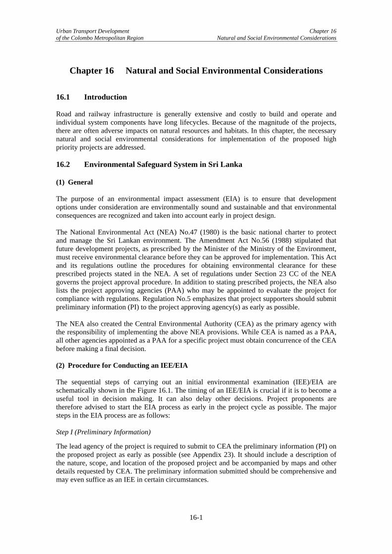
Urban Transport Development Chapter 16 of the Colombo Metropolitan Region Natural and Social Environmental Considerations
Chapter 16 Natural and Social Environmental Considerations 16.1 Introduction Road and railway infrastructure is generally extensive and costly to build and operate and individual system components have long lifecycles. Because of the magnitude of the projects, there are often adverse impacts on natural resources and habitats. In this chapter, the necessary natural and social environmental considerations for implementation of the proposed high priority projects are addressed. 16.2 Environmental Safeguard System in Sri Lanka (1) General The purpose of an environmental impact assessment (EIA) is to ensure that development options under consideration are environmentally sound and sustainable and that environmental consequences are recognized and taken into account early in project design. The National Environmental Act (NEA) No.47 (1980) is the basic national charter to protect and manage the Sri Lankan environment. The Amendment Act No.56 (1988) stipulated that future development projects, as prescribed by the Minister of the Ministry of the Environment, must receive environmental clearance before they can be approved for implementation. This Act and its regulations outline the procedures for obtaining environmental clearance for these prescribed projects stated in the NEA. A set of regulations under Section 23 CC of the NEA governs the project approval procedure. In addition to stating prescribed projects, the NEA also lists the project approving agencies (PAA) who may be appointed to evaluate the project for compliance with regulations. Regulation No.5 emphasizes that project supporters should submit preliminary information (PI) to the project approving agency(s) as early as possible. The NEA also created the Central Environmental Authority (CEA) as the primary agency with the responsibility of implementing the above NEA provisions. While CEA is named as a PAA, all other agencies appointed as a PAA for a specific project must obtain concurrence of the CEA before making a final decision. (2) Procedure for Conducting an IEE/EIA The sequential steps of carrying out an initial environmental examination (IEE)/EIA are schematically shown in the Figure 16.1. The timing of an IEE/EIA is crucial if it is to become a useful tool in decision making. It can also delay other decisions. Project proponents are therefore advised to start the EIA process as early in the project cycle as possible. The major steps in the EIA process are as follows: Step I (Preliminary Information)
The lead agency of the project is required to submit to CEA the preliminary information (PI) on the proposed project as early as possible (see Appendix 23). It should include a description of the nature, scope, and location of the proposed project and be accompanied by maps and other details requested by CEA. The preliminary information submitted should be comprehensive and may even suffice as an IEE in certain circumstances.
16-1

Urban Transport Development Chapter 16 of the Colombo Metropolitan Region Natural and Social Environmental Considerations
Preliminary Information(PI)
Scoping
IEE or EIA?IEE required EIA required
PI accepted as IEE Set TOR
Preparation of IEE Report
Decision?
Approved withConditions
Notice to Public
Preparation of EIA Report
Set TOR
Public Notice
Response to Commentsby PP
Not Approved
Appeal
Yes
No
Further Information
No
Adequacy ofReport
Public Notice
Forward Comments toProject Proponent(PP)
Response to Commentsby PP
Decision?
Approved withConditions
Notice to Public
Not Approved
Appeal
Forward Comments toProject Proponent(PP)
Source: Guidance for Implementing the EIA Process (CEA: 1998)
Figure 16.1 IEE/EIA Procedures in Sri Lanka
16-2

Urban Transport Development Chapter 16 of the Colombo Metropolitan Region Natural and Social Environmental Considerations
Step II (Environmental Scoping)
The NEA has identified two levels of EIA reports depending on the severity and significance of the anticipated impacts. The first level, an IEE, is a report that assesses the possible impacts of a prescribed project for their significance and identifies mitigation measures and recommendations. The second level, an EIA, is a more comprehensive document where alternatives to the proposed project are identified and the alternative with the least environmental impacts is assessed and mitigatory measures for this option are recommended. Environmental scoping is the process where projects undergo a preliminary assessment by the PAA and CEA to identify environmental impacts in order to determine whether the project requires an EIA or IEE and thereby define the scope of the study required. Environmental issues involve national, regional, and local government agencies and cover a broad range of responsibilities (wildlife, health, water, land use, tourism, etc.). Thus, coordination among government agencies and the public is crucial. This is best achieved through interagency scoping meetings to identify issues, types of analysis, and mitigation measures. The Terms of Reference (TOR) for the assessment is the primary outcome of the scoping process. Step III (Public Participation)
Involving the public is one of the major aspects of the EIA process. The NEA provides for public participation and stipulates that a notice of availability of the EIA report for public review must be inserted in one Sinhala, Tamil, and English newspaper, as well as in the gazette. Thirty days are allowed for public review. Once public comments are received it is decided whether the case warrants a public hearing. The public comments received during the thirty day period must be sent back to the project proponent for review and response. The lead agency is obligated to respond to the comments by (i) making an effort to modify alternatives including the proposed action; (ii) develop and evaluate alternatives not provided; (iii) give serious consideration to providing supplementary information in the document; and (iv) make factual corrections. All substantive comments received on the draft should be attached to the final statement. Step IV (Decision Making)
According to the regulations, the PAA, in concurrence with the CEA, shall grant approval for the project subject to specified conditions or refuse to approve the project. If the latter is chosen, reasons must be given. The lead agency can appeal to the Secretary of the Ministry of the Environment. A member of the public must seek an appeal in court. Step V (Monitoring)
The success of the EIA process depends wholly on monitoring during implementation. The regulations state that the PAA should forward a report to the CEA within 30 days which contains a plan to monitor project implementation. This includes monitoring the compliance with the conditions outlined and the effectiveness of the mitigation measures. 16.3 Capacity Building Project Proposed by SNEWG As mentioned in Chapter 11, the Working Groups identified twelve capacity building projects. These inexpensive projects were prepared to rectify sectoral and institutional knowledge capacity shortcomings and they are therefore fundamental to facilitate the high priority projects recommended in Chapter 17. Therefore, these capacity building projects should be considered high priority and no further screening is considered necessary.
16-3

Urban Transport Development Chapter 16 of the Colombo Metropolitan Region Natural and Social Environmental Considerations
Based on discussions in the Social and Natural Environment Working Group (SNEWG), one capacity building project was proposed. Env-1: Institutional Strengthening to Increase Capacity of Vehicle Inspection, Roadside Inspection, Emission Inspection, and Monitoring Given that road traffic congestion in Colombo will increase significantly in the near future, institutional strengthening to improve capacity to manage the urban environment is considered indispensable. Areas requiring institutional strengthening include: (i) vehicle inspection; (ii) roadside inspection; (iii) emission inspection; and (iv) monitoring of transport operation. Anticipated Tasks
Capacity building to improve CMT & Police vehicle inspection system: This focuses on improving the vehicle inspection system to reduce pollution from vehicle emissions, which requires expediting the existing vehicle inspection programs that are comprised of three types of inspection: (i) used vehicle testing at port of entry; (ii) the mandatory annual testing of the physical and operating conditions of a vehicle that results in a certificate or license being issued by the Department of Motor Traffic; and (iii) roadside inspections by the Police. The legal framework needed to implement these programs has already been established, but the equipment and trained personnel required to carry out the inspections are inadequate.
Capacity building of CPC & CEA to conduct roadside fuel inspection: Procurement of the necessary equipment to test fuel for adulteration will be necessary to control this practice. In addition, training of CPC and CEA staff to conduct proper testing of fuel for adulteration is also necessary. Capacity building of CEA & CMT to improve emission/ noise testing capabilities: This capacity building of CEA and CMT will be undertaken to reduce emission and noise pollution from vehicle, and consists of procuring the required equipment for testing vehicle emissions and training CEA and CMT staff to undertake the proper testing methods. Capacity building of CEA, RDA, Police, CMT to improve transport operational monitoring: Capacity building of the Police, RDA, CEA, and CMT will be conducted to improve the monitoring of vehicle operations, and will include the procurement of required equipment for such monitoring. Benefits
There are extensive long-term benefits with regards to building the capacity of these organizations, as they will then be able to continue the monitoring of vehicle emissions in the future. Risks
There are no risks associated with this project.
16-4
Urban Transport Development Chapter 16 of the Colombo Metropolitan Region Natural and Social Environmental Considerations
16.4 Applicable Environmental Safeguard System for the Study Projects (1) JICA Guidelines for Environmental and Social Considerations JICA environmental and social guidelines classify projects into three categories based on the extent of environmental and social impacts. This classification takes into account the outline of a project, its scale, site conditions, and the environmental impact assessment scheme in the host country. The definitions of the categories are as follows. Category A: Projects are classified as Category A if they are likely to have significant adverse environmental and social impacts. Projects with complicated, irreversible, or unprecedented impacts that are difficult to assess are also classified as Category A. Projects are also classified as Category A if they require a detailed EIA as stipulated under the environmental laws and standards of the recipient government. The impacts may affect a broad area or facilities subject to physical construction. Category A, in principle, includes projects in sensitive sectors (i.e., characteristics that are liable to cause adverse environmental impacts) and projects located in or near sensitive areas. Category B: Projects are classified as Category B if their potential adverse environmental and social impacts are less adverse than those projects in Category A. Generally, these impacts are site-specific, have few, if any, irreversible impacts, and in most cases, normal mitigation measures can be designed relatively easily. Category C: Projects are classified as Category C if they are likely to have minimal or little adverse environmental and social impacts. As for Category A projects, an EIA-level environmental and social examination including a monitoring plan, institutional arrangements, and mitigation measures to avoid, minimize, or compensate for adverse impacts is carried out. In the case of a Category B project, an IEE-level environmental and social examination in which alternatives are analyzed (including a without project scenario) is performed. Category C projects, because of their negligible impacts, do not require any sort of environment assessment. (2) JBIC Guidelines for Environmental and Social Considerations JBIC environmental and social guidelines also stipulate three project classifications – Categories A, B, and C with same definitions of those of JICA’s guidelines. JBIC’s guidelines also have an additional project category – Category FI. A proposed project is classified as Category FI if it satisfies all of the following: (i) JBIC’s project funding is provided to a financial intermediary; (ii) the selection and assessment of actual projects is undertaken by the intermediary only after JBIC’s funding approval and therefore the projects cannot be specified prior to JBIC’s funding approval or assessment of the project; and (iii) those sub-projects are expected to have potential impact on the environment. (3) Applicable Safeguard System to the Proposed Project JICA guidelines stipulate that projects must comply with the laws, ordinances, and standards relating to environmental and social considerations established by the governments that have jurisdiction over the project site. As already mentioned above, the Sri Lanka Government has its own EIA system established under NEA. Therefore, the proposed projects will be subject to environmental certification under NEA.
16-5

Urban Transport Development Chapter 16 of the Colombo Metropolitan Region Natural and Social Environmental Considerations
16-6
Urban Transport Development Chapter 17 of the Colombo Metropolitan Region Selection of High Priority & Pre-FS Projects
Chapter 17 Selection of High Priority and Pre-FS Projects 17.1 Introduction This chapter describes the process for selecting high priority projects from those projects short-listed in Chapter 11 and which were elaborated on in Chapters 12-16. In addition, this chapter will discuss the overall programming of the different high priority projects and make recommendations regarding implementation. Note that some of the high priority projects were then taken up for further analysis at the pre-feasibility study (pre-FS) stage, which began in July 2006. 17.2 Process for Selecting High Priority and Pre-FS Projects The process for selecting high priority projects is shown in Figure 17.1. As the figure indicates, this process is a continuation of that described in Figure 11.1. The shaded portion indicates the completed short-listing process and the unshaded portion outlines the process discussed in this chapter – high priority and pre-FS project selection, which is discussed below. (1) High Priority Projects Short-listed projects were classified as non-infrastructure (capacity building and soft) and infrastructure (hard) projects. For short-listed non-infrastructure projects, like capacity building and soft projects, the Study Team recommends that all of them be implemented. They are relatively inexpensive and contribute either to the better coordination or quality of transport services. Because non-infrastructure projects produce no physical structures or output, benefits are extremely difficult to quantify and qualitative analyses is usually more appropriate. This qualitative analysis includes risk assessment, implementation organizations, costing, etc. and is described in Chapters 12-16. Therefore, no pre-FS studies will be conducted on non-infrastructure or capacity building projects, although the Study Team again reiterates the paramount importance of these projects as high priority projects. The work content of capacity building projects is the same as that of the non-infrastructure projects and should be implemented quickly, since they provide a better environment for ensuring project sustainability. Given this, all non-infrastructure and capacity building projects are considered to be high priority projects in this report. Those infrastructure projects that can be defined as high priority are those that contribute to optimizing significant strategic pipeline projects – the Outer Circular Highway (OCH) and extension of Baseline Road. That is, a high priority infrastructure project should improve transport corridors that promote the optimization of these strategic pipeline projects as well as the transport corridors themselves, as this will have significant impacts on reducing congestion. Schemes passing this screening were then examined for suitability as pre-FS projects, which will include economic analysis and conceptual design. (2) Pre-FS Projects Pre-FS projects, which will require design drawings, economic analyses based on forecasted traffic flows, and a rough assessment of social/environmental impacts, are selected from the high priority infrastructure projects by eliminating pipeline projects and those projects deemed to unsuitable for pre-FS level analysis (see (4) of 17.3 for details).
17-1
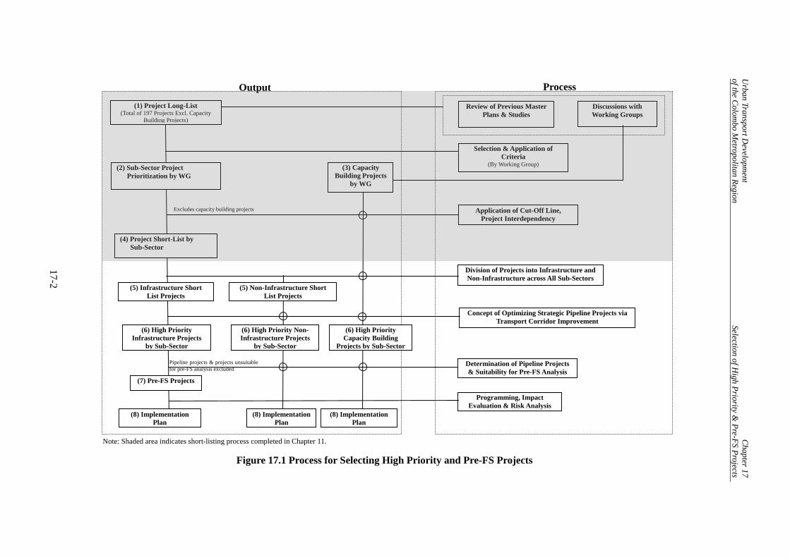
U
rban of th
Transport Developm
ent C
hapter 17e C
olombo M
etropolitan Region Selection of H
igh Priority & Pre-FS Projects
17-2
Review of Previous Master Plans & Studies
(1) Project Long-List (Total of 197 Projects Excl. Capacity
Building Projects)
Selection & Application of Criteria
(By Working Group) (2) Sub-Sector Project Prioritization by WG
Application of Cut-Off Line, Project Interdependency
(4) Project Short-List by Sub-Sector
(6) High Priority Infrastructure Projects
by Sub-Sector
Division of Projects into Infrastructure and Non-Infrastructure across All Sub-Sectors
Excludes capacity building projects
Discussions with Working Groups
(5) Infrastructure Short List Projects
(3) Capacity Building Projects
by WG
(7) Pre-FS Projects
(8) Implementation Plan
Determination of Pipeline Projects & Suitability for Pre-FS Analysis
Pipeline projects & projects unsuitablefor pre-FS analysis excluded
(8) ImplementationPlan
(8) Implementation Plan
Concept of Optimizing Strategic Pipeline Projects via Transport Corridor Improvement
Output Process
(5) Non-Infrastructure Short List Projects
(6) High Priority Capacity Building
Projects by Sub-Sector
(6) High Priority Non-Infrastructure Projects
by Sub-Sector
Programming, Impact Evaluation & Risk Analysis
Note: Shaded area indicates short-listing process completed in Chapter 11.
Figure 17.1 Process for Selecting High Priority and Pre-FS Projects

Urban of th
Transport Development Chapter 17 e Colombo Metropolitan Region Selection of High Priority & Pre-FS Projects
17-3
(3) Implementation Plans Implementation plans will take into account tasks, timelines, costs, impact evaluation, benefits, and risks and are prepared for all relevant project types. 17.3 High Priority and Pre-FS Projects (1) Potential High Priority Infrastructure Projects Based on the preceding, the Study Team prepared a list of 22 high priority infrastructure projects as shown in Table 17.1 that include pipeline schemes (i.e., committed projects). Note that of these 22 projects, four are for public transport, three are for traffic management and safety, and fifteen are for road improvement. However, this list covers potential projects which will be finalized through pre-feasibility study in Chapter 18 to 25.
Table 17.1 Potential High Priority Infrastructure Projects
Project by Sub-Sector Project Name Implementing
Agency Public Transport 1. Rail-1: Rehabilitation of Rail Siding & Rail Facilities on the Coastal, Main,
KV, and Puttlam Lines SLR
2. Rail-2: Rehabilitation of Signaling, and Communications System on the Coastal, Main, KV, and Puttlam Lines
SLR
3. BRT-1: Develop Bus Rapid Transit System UDA 4. Bus-8: Develop Bus Stop Facilities on High Demand Corridors CMC, RDA Traffic Management and Safety 5. TM-1: Intersection Geometric Improvement CMC, RDA 6. TM-2: Area Traffic Control System CMC, Traffic
Police 7. TM-6: Corridor Traffic Mgt Improvement CMC, RDA Road Improvement 8. Road-1: Outer Circular Highway (OCH) Construction RDA 9. Road-6: Extension of Baseline Road (Phase 3) & Baseline Road Improvement RDA 10. Road-7: Marine Drive Extension Construction (including 1 flyover) RDA 11. Road-14: B152 Widening & Improvement of Access Roads B425 and
Eppamulla-Panunugama Road RDA
12. Road-15: Improvement of Colombo-Horana Road (including Kohuwala Flyover construction)
RDA
13. Road-16: Improvement of Kirulapone-Kottawa Road (Rt. A4) RDA 14. Road-17: Improvement of Kandy Road - Phase I (construction of 1 flyover & 1
interchange) RDA
15. Road-18: Improvement of Kandy Road [Phase II] RDA 16. Road-20 Improvement of Rajagiriya-Ratmalana Road RDA 17. Road-21: Improvement of Road from Pannipitiya to Battaramulla RDA 18. Road-43: Grade-Separated Interchange Construction at Rajagiriya Intersection RDA 19. Road-49: Intermodal Transport Center [Suburban Area] UDA 20. Road-50: Intermodal Transport Center [CMC Area] UDA 21. Road-WP2 Improvement of Pittakotte-Thalawathugoda-Hokandara-
Kokadawila Road WPRDA
22. Road-WP4 Improvement of Pannipitiya-Moralatiya-Tumbowila Road WPRDA Note: Projects in italics are pipeline projects. Note, however, that the improvement component of Road-6 and the Kohuwala Flyover of Road-15 are not pipeline projects.

Urban Transport Development Chapter 17 of the Colombo Metropolitan Region Selection of High Priority & Pre-FS Projects
The short-listed projects that were eliminated in the screening process from the infrastructure project high priority list and the reasons for this are as described in Table 17.2.
Table 17.2 Short-Listed Infrastructure Projects not Considered as High Priority
Project Reasons for Elimination Traffic Management and Safety 1. TM-3: Traffic Signal
Rehabilitation With the implementation of ATC, which is strongly recommended by the Study Team, this project is unnecessary.
Road Improvement 2. Road-10: Duplication Road
Extension Construction Social impacts are relatively high in comparison to expected benefits.
3. Road-26: Improvement of Road from Nugegoda-Ethul Kotte Road via Jubili Post
Social impacts are relatively high in comparison to expected benefits.
4. Road-33: Improvement of Balummahara-Biyagama-Malabe Road
Class B roads outside of the OCH area.
5 Road WP1 Improvement of Pelawatta-Malabe-Kahantota Road
The alignment runs parallel to Road WP2 project.
6 Road-WP5 Improvement of Piliyandala-Henamulla Road
Implementation cost are relatively high in comparison to expected benefits because it contains new bridge construction
(2) High Priority Non-Infrastructure Projects As mentioned previously, all short-listed non-infrastructure projects are to be considered as high priority owing to their cost-efficiency and contribution to improving public transport services overall. The list of high priority non-infrastructure projects is as shown in Table 17.3. Note that there are a total of eight projects, with one institutional, three public transport, and four traffic management and safety schemes.
Table 17.3 High Priority Non-Infrastructure Projects
Project Implementing Agency Institutional 1. Inst-1 Technical Assistance to Establish the Presidential
Committee on Urban Transport (PCUT) and Secondary Coordination Mechanisms
MoRT
Public Transport 2. Bus-1Technical Assistance to Lay Groundwork for Bus Route
Concessioning and Undertake a Pilot Concessioning Project NTC, WPRPTA
3. Bus-2 Project to Increase Intermodal and Intramodal Coordination by Timetable Creation, Implementation and Enforcement
WPRPTA
4. PT-1 Project to Improve School Transport Services NTC Traffic Management and Safety 5. TM-11: Study on Staggered School/Office Start Times and
Traffic Management Options MoRT, Traffic Police, and CMC
6. TM-13 Road User Education Program National Council for Traffic Safety, MoRT, CMC
7. TM-14 Traffic Safety Improvement Project National Council for Traffic Safety, MoRT
17-4

Urban Transport Development Chapter 17 of the Colombo Metropolitan Region Selection of High Priority & Pre-FS Projects
(3) High Priority Capacity Building Projects Similar to the logic for short-listed non-infrastructure projects, all capacity building projects are considered as high priority due to their expected positive impacts and low costs. The list of high priority capacity building projects is as shown in Table 17.4.
Table 17.4 High Priority Capacity Building Projects
Project Implementation Agency
Public Transport 1. Bus 3: Strengthening of NTC on Transport Planning and
Operations/Management NTC
2. Bus 4: Strengthening of SLTB on Operations/ Management SLTB 3. Bus 5: Develop a Training Center at WPRPTA and Undertake Strengthening of
WPRPTA, Private Bus Owners/Operators, and Crew WPRPTA
4. Rail 3: Strengthening of SLR on Management and Operations and Development of a Strategic Business Unit to Implement Pilot Projects
SLR
5. 3W-1: Strengthen the WPRPTA to Implement and Strengthen the Three-Wheeler Services Bureau and Outline Three-Wheeler Regulations
WPRPTA
Road Improvement 6. Road 48: Capacity Building of CMC - Drainage Maintenance CMC 7. Road 54: Capacity Building of RDA – Land Acquisition & Resettlement RDA 8. Road 55: Capacity Building of RDA – Road Design Standards and
Maintenance Coordination RDA
Traffic Management and Safety 9. TM-17: Capacity Building of CMC and RDA - Traffic Management & Safety CMC 10. TM-19: Capacity Building of Traffic Police Traffic Police Social and Natural Environment 11. Env-1: Cross-Sector Capacity Building - For Personnel and Equipment for
Vehicle Inspection, Roadside Inspection, Emission Inspection, & Monitoring CMT, Police, RDA, CPC, CEA
17-5

Urban Transport Development Chapter 17 of the Colombo Metropolitan Region Selection of High Priority & Pre-FS Projects
(4) Pre-FS Projects The twelve pre-FS projects proposed for this Study are listed in Table 17.5 and were obtained by excluding pipeline projects and those projects unsuitable for pre-FS analysis, including those facing implementation or serious sustainability problems. Pipeline projects are not being considered because (i) their feasibility has already been examined and/or (ii) there is a strong commitment from other donors or private financing. Rail-1 and Rail-2 face sustainability problems as the Study Team believes that the sustainability of the proposed work is low and that the capacity building measures described in Rail-3 (see Table 17.4) should be implemented and monitored first before Rail-1 and Rail-2 are implemented. Other projects deemed unsuitable for pre-FS analysis are Road-49 and Road-50, which consist of providing park ‘n’ ride facilities, taxi stands, etc. and are excluded from consideration as they mainly consist of intermodal coordination and parking facility management with little infrastructure involved. Bus-8, which will improve the quality of individual bus stops, is also removed as it will be difficult to quantify the economic impacts of this work. Note that TM-1 is removed as a separate project, since it makes more sense from a technical and analytical viewpoint to subsume it under TM-6. The locations of the ten pre-FS projects are shown in Figure 17.2 using a color-coded scheme. Regarding the timing and composition of the pre-FS projects, some such as traffic management will be completed around 2010. On the other hand, the larger infrastructure projects, such as the extension of Marine Drive, will be completed after 2010, but before 2015. 2015 was the cut-off date for any project’s completion in this Study.
Table 17.5 Pre-FS Projects
Project\by Sub-Sector Project Name Implementing
Agency Traffic Management and Safety 1. TM-2: Area Traffic Control System* CMC &Traffic
Police 2. TM-6: Corridor Traffic Management Improvement CMC & RDA Road Improvement 3. Road-6 Baseline Road Improvement (Construction of 2 flyovers) RDA 4. Road-7: Marine Drive Extension Construction RDA 5. Road-14: B152 Widening & Improvement of Access Roads B425
and Eppamulla-Panunugama Rd RDA
6. Road-15: Kohuwala Flyover Construction 7. Road-17: Improvement of Kandy Road-Phase I (construction of 2
flyovers) RDA
8. Road-20 Improvement of Rajagiriya-Ratmalana Road RDA 9. Road-21: Improvement of Road from Pannipitiya to Battaramulla RDA 10. Road-43: Grade-Separated Interchange Construction at Rajagiriya
Intersection (Construction of 1 flyover) RDA
11. Road-WP2 Improvement of Pittakotte–Thalawathugoda–Hokandara–Kokadawila Road
WPRDA
12. Road-WP4 Improvement of Pannipitiya–Moralatiya–Tumbowila Road
WPRDA
*: Work for TM-1 is included. Note that a project can consist of several components. For example, Project Road-17 consists of the construction of a flyover and an interchange on Kandy Road, while Project TM-6 consists of intersection improvements on various corridors. The ATC project, on the other hand, would cover an area slightly larger than the CMC and deal with all intersection signaling on the
17-6

Urban Transport Development Chapter 17 of the Colombo Metropolitan Region Selection of High Priority & Pre-FS Projects
various roads in this vicinity. The type of work content that the pre-FS projects will entail is as indicated in Table 17.6.
Table 17.6 Work Content of Pre-FS Projects
Project Road Construction & Widening
Potential FlyoverConstruction
Intersection Improvement
TM-2 TM-6 Road -6 Road-7 Road-14 Road-15 Road-17 Road-20 Road-26 Road-43 RoadWP-2 RoadWP-4
17-7
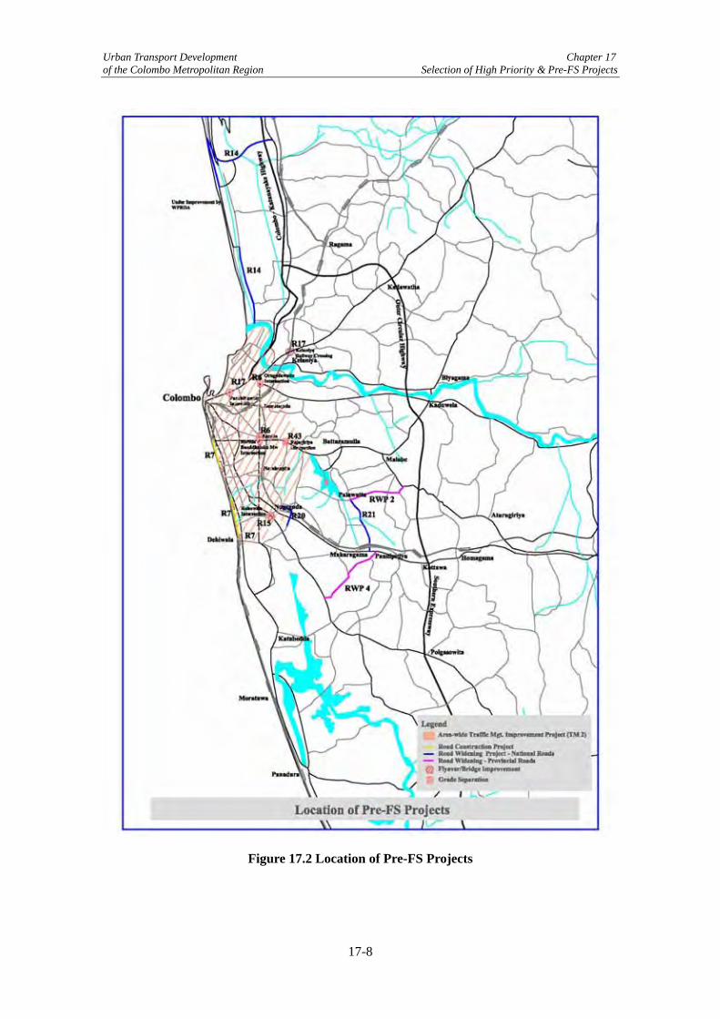
Urban Transport Development Chapter 17 of the Colombo Metropolitan Region Selection of High Priority & Pre-FS Projects
Figure 17.2 Location of Pre-FS Projects
17-8

Urban Transport Development Chapter 17 of the Colombo Metropolitan Region Selection of High Priority & Pre-FS Projects
17.4 Project Programming International and previous Colombo experience demonstrates that one-off or stand-alone projects do little to reduce traffic congestion. Typically congestion is just shifted, not reduced. Also, physical infrastructure projects without softer components do little to improve the situation as well. The outcome is that to reduce traffic congestion, both indirect measures (capacity building, enforcement, operations) and direct measures (road widening, expansion, signaling) must be utilized. Therefore, the Study Team believes that it is crucial that projects that both indirectly and directly reduce traffic congestion be programmed together to complement each other and implemented in a way to maximize benefits and minimize costs. The basic approach is outlined in Table 17.7 and as shown, preparations to implement all of the high priority projects would begin next year. Specific sector programming showing the temporal relationship between the projects is shown in tables 17.8 – 17.13. Specific tasks for each project are listed in Appendices 20 and 21. High priority capacity building projects should be completed by the end of 2008 and will focus on creating conditions to promote the sustainability of both the high priority non-infrastructure and infrastructure projects to follow. High priority non-infrastructure projects should be completed by 2010. The Study Team wants to stress Inst-1 and Bus-1, projects to establish a Presidential Committee on Urban Transport (PCUT) and to implement pilot projects for bus franchising with the goal of introducing this system of operation throughout Western Province. The Study Team thinks that PCUT is fundamental to effectively coordinating the transport projects being proposed in this Study, as well as to transport policy and schemes in general, and should be in operation by the end of 2007 at latest via cabinet approval, with parliamentary approval to hopefully come by 2010. As for Bus-1, the Study Team believes that franchising will have significant positive impacts on resolving bus operational issues in Colombo, although given previous strong resistance, the Study Team recommends pilot projects initially and building on their success for full rollout. Finally, the completion date of most high priority infrastructure projects will be beyond 2010, because of their scale, cost, and complexity. These projects will build on the results of the capacity building and non-infrastructure projects, and initially focus on operational capacity improvements (such as traffic management measures) followed by increasing physical capacity, as the margin of returns on improving operational capacity decreases. This supports the belief that it is crucial to maximize existing infrastructure before constructing new infrastructure in order to optimize economic benefits and ensure that unnecessary and costly work is not carried out. This concept is illustrated in Figure 17.3. As this figure indicates, after the operational capacity threshold is reached for a particular acceptable minimum level of service new infrastructure should then be planned.
Table 17.7 Basic Project Programming for High Priority Projects
Type of Project 2007 2008 2009 2010 2011 2012 2013 2014 2015Capacity Building Projects
Creating Conditions to Ensure Project Sustainability
Non-Infrastructure Projects
Emphasis on Rationalizing the Coordination, Management, and
Safety Aspects of Transport
Infrastructure Projects
Emphasis on Increasing Operational Capacity of Transport
Emphasis on Increasing Physical Capacity
17-9

Urban Transport Development Chapter 17 of the Colombo Metropolitan Region Selection of High Priority & Pre-FS Projects
Table 17.8 Project Programming for High Priority Rail Projects
2007 2008 2009 2010 2011 2012 2013 2014 2015
Inst-1Establish Presidential Committee on Urban Transport (PCUT)
Bus-2 Increase Intermodal and Intramodal Coordination
Rail-3Strengthening of SLR on Planning and Operations/Management
Road-49 Intermodal Transport Center [Suburban Area]Road-50 Intermodal Transport Center [CMC Area] Rail-1 Rehabilitation of Rail Siding, Rail Facilities,
Rail-2 Rehabilitation of Signaling, and Communications Systems
Project Name
Table 17.9 Project Programming for High Priority Bus Projects 2007 2008 2009 2010 2011 2012 2013 2014 2015
Inst-1Establish Presidential Committee on Urban Transport (PCUT)
Bus-3Strengthening of NTC on Transport Planning and Operations/Management
Bus-4 Strengthening of SLTB on Operations/ManagementBus-5 Strengthening of WPRPTABus-2 Increase Intermodal and Intramodal Coordination
Bus-8 Develop Bus Stop Facilities on High Demand Corridors
Bus-1 Lay Groundwork for Bus Franchising and Undertake a Pilot Franchising Project
Road-49: Intermodal Transport Center [Suburban Area]Road-50 Intermodal Transport Center [CMC Area] BRT-1 Develop Bus Rapid Transit System
Project Name
Table 17.10 Project Programming for High Priority Three-Wheeler Projects 2007 2008 2009 2010 2011 2012 2013 2014 2015
Inst-1Establish Presidential Committee on Urban Transport (PCUT)
3W-1 Strengthen WPRPTA
Project Name
Table 17.11 Project Programming for High Priority School Transport Projects 2007 2008 2009 2010 2011 2012 2013 2014 2015
Inst-1Establish Presidential Committee on Urban Transport (PCUT)
PT-1 Project to Improve School Transport Services
TM-21Evaluate Staggering and Traffic Management Options of School/Office Start Times
Project Name
17-10
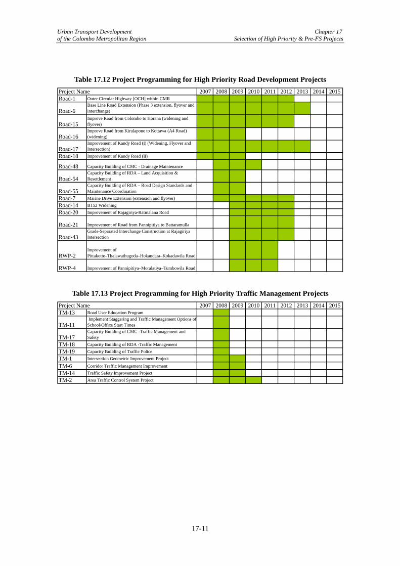
Urban Transport Development Chapter 17 of the Colombo Metropolitan Region Selection of High Priority & Pre-FS Projects
Table 17.12 Project Programming for High Priority Road Development Projects
2007 2008 2009 2010 2011 2012 2013 2014 2015Road-1 Outer Circular Highway [OCH] within CMR
Road-6Base Line Road Extension (Phase 3 extension, flyover and interchange)
Road-15Improve Road from Colombo to Horana (widening and flyover)
Road-16Improve Road from Kirulapone to Kottawa (A4 Road) (widening)
Road-17Improvement of Kandy Road (I) (Widening, Flyover and Intersection)
Road-18 Improvement of Kandy Road (II)
Road-48 Capacity Building of CMC - Drainage Maintenance
Road-54Capacity Building of RDA – Land Acquisition & Resettlement
Road-55Capacity Building of RDA – Road Design Standards and Maintenance Coordination
Road-7 Marine Drive Extension (extension and flyover)Road-14 B152 WideningRoad-20 Improvement of Rajagiriya-Ratmalana Road
Road-21 Improvement of Road from Pannipitiya to Battaramulla
Road-43Grade-Separated Interchange Construction at Rajagiriya Intersection
RWP-2Improvement of Pittakotte–Thalawathugoda–Hokandara–Kokadawila Road
RWP-4 Improvement of Pannipitiya–Moralatiya–Tumbowila Road
Project Name
Table 17.13 Project Programming for High Priority Traffic Management Projects 2007 2008 2009 2010 2011 2012 2013 2014 2015
TM-13 Road User Education Program
TM-11 Implement Staggering and Traffic Management Options of School/Office Start Times
TM-17Capacity Building of CMC -Traffic Management and Safety
TM-18 Capacity Building of RDA -Traffic ManagementTM-19 Capacity Building of Traffic PoliceTM-1 Intersection Geometric Improvement Project
TM-6 Corridor Traffic Management ImprovementTM-14 Traffic Safety Improvement ProjectTM-2 Area Traffic Control System Project
Project Name
17-11

Urban Transport Development Chapter 17 of the Colombo Metropolitan Region Selection of High Priority & Pre-FS Projects
● Construction of
Flyover
● Road Widening
High
Low
● Area-wide
Traffic Control
Low
Cost of Im
provement M
easures
Traffic VolumeHigh
● Individual Intersection
Signalization
● Signal Coordination
● Pedestrian Facility
Improvement
● Reconfiguration of
Intersections
Increase in Physical Capacity
Operational C
apacity
Threshold
Note: Improvements could be timed in order to maintain a pre-determined level of service (travel speed) Figure 17.3 Concept Drawing of Corridor Capacity Improvement and Implementation
Timing
17-12

Urban Transport Development Chapter 18 of the Colombo Metropolitan Region Methodology for Pre-Feasibility Studies
Chapter 18 Methodology for Pre-Feasibility Studies 18.1 Introduction Previous chapters of this report have presented recommendations on high priority projects and potential pre-feasibility (pre-FS) studies, which contain measures for reducing traffic within the short-term (by 2010), as well as the medium-term (by 2015). Pre-FS projects can be grouped into three categories based on the design work required, including:
• Road extension or widening; • Grade separation; and • ATC installation and intersection improvement.
(1) Road Extension and Widening Projects Road sections to be included as pre-FS are shown in Table 18.1. RDA has prepared detailed designs for certain sections as indicated in the table; therefore, new design work will be performed only for the remaining sections with a brief review of the completed design work.
Table 18.1 Road Extension and Widening Pre-FS Projects
Project Code Project Name Scheme Section and Length
Existence of RDA Design
New-4 lanes 2 km Bambalapitiya to Kollupitiya
√
New-4 lanes 1.75 km Ramakrishna Road to Dehiwala
Road-7 Marine Drive Extension
Widening-4 lanes Approach roads Road-14 Widening-2 lanes Mattakkuliya Bridge to
Uswetakeyyawa Bridge (5.2 km on B152)
√
B152/B425 Widening
Widening-2 lanes Tudella Junction to Pamunugama Bridge (5.8 km)
Widening-2 lanes Eppamulla-Pamunugama Road (2.8 km)
Road-20 Widening-2 lanes Nugegoda Intersection to Katiya Handiya (0.8 km)
Widening-2 lanes Katiya Handiya to High Level Road (0.5km)
√
Nugegoda-Katiya Junction-Pepiliyana Road Widening
Widening-2 lanes incl. a bridge
Gamsaba Junction to Bridge location along Dehiwala Road (0.8 km)
√
Road-21 Thalawatugoda-Pannipitiya Road Widening
Widening-4 lanes Thalawatugoda Junction to Pannipitiya Flyover (3.2km)
√
RWP-2 Thalawatugoda-Koskadwila Road Widening
Widening-2 lanes Thalawatugoda Junction to Koskadwila Junction (4.2km)
RWP-4 Pannipitiya-Tumbowil Road Widening
Widening-2 lanes Pannipitiya Junction to Tumbowil Junction (7.2km)
18-1

Urban Transport Development Chapter 18 of the Colombo Metropolitan Region Methodology for Pre-Feasibility Studies
The study items and contents of the road related pre-FS projects are shown in Table 18.2. Preliminary design work and costing will be done excluding sections where design has already been carried out by the implementing agency. However, economic analysis will be incorporated for all sections.
Table 18.2 Contents of Pre-Feasibility Studies for Road Related Projects
Item Contents a. Consistency with upper
level plans Examined in Part I of this report.
b. Impact on reducing congestion
Impact on reducing congestion has been qualitatively assessed by the Working Groups. Time saving will be calculated by using a network simulation model. Traffic assignment models (JICA STRADA) will be used for demand forecasting and time/operation cost savings. Note that vehicle origin/destination trips (used in OCH study) were updated in this Study.
c. Evaluation of alternatives Study routes have been selected from alternative routes. Required width and number of lanes will be determined by using traffic demand forecasting results.
d. Design specification Route location map (utilizing existing satellite photos) will be prepared. RDA standards will be applied for deciding the cross section and pavement structure of roads.
e. New surveys conducted Roadside traffic counts have been conducted in Phase I. Satellite photos are obtained for each site to be used as base maps. No additional surveys are required, except for site visits to determine design constraints.
f. Costing Preliminary cost estimates will be made for land acquisition, construction, relocation/compensation, operation/maintenance, etc.
g. Economic analysis Time saving and operational cost savings will be estimated by using JICA STRADA model, and used in the economic analysis. An economic internal rate of return (EIRR) for evaluation scenarios will be calculated.
h. Implementing organization Existing implementing organizations to be utilized; i.e., RDA. i. Implementation schedule To be prepared in this Study. j. Operation/maintenance
organization Existing implementing organizations to be utilized; i.e., RDA.
k. Environmental/social impact
Identification of critical parameters and development of mitigation measures will be made. (No EIA/IEE will be conducted in this Study).
(2) Grade Separation Projects Grade separation is considered at seven locations as shown in Table 18.3. RDA has already prepared designs for some of these locations, so preliminary design work will be performed only for the sections that have not yet been considered.
18-2

Urban Transport Development Chapter 18 of the Colombo Metropolitan Region Methodology for Pre-Feasibility Studies
Table 18.3 Grade Separation Pre-FS Projects
Project Code Project Name Scheme Location
Existence of RDA Design
Orugodawatte Flyover (Baseline Road)
Flyover Orugodawatte (Baseline Road-Avissawella Road)
Road-6
Borella-Kanata Flyover (Baseline Road)
Interchange Borella-Kanata Junction (Baseline Road-Ward Place, Horton Place, and Bauddhaloka Mawatha)
Road-7 Dehiwala Flyover Flyover Dehiwala Junction (Galle Road-Station Road)
√
Road-15 Kohuwala Flyover Flyover Kohuwala Junction (Dutugemunu Street-S. des S Jayasihgha Mawatha)
Armour Street Flyover
Interchange Armour Street Junction in Panchikawatte area (George R. de Silva Mw-Jethawana Road)
Road-17
Kelaniya Railway Flyover
Flyover Railway Crossing (Kandy Road-SLR Main Line)
√
Road -43 Rajagiriya Flyover Interchange Rajagiriya-Welikada Junction (Sri Jayewardenepura Mw.-Nawala Road)
The study items and contents of pre-FS flyover construction projects are shown in Table 18.4. Preliminary design work and costing will be done excluding intersections where flyover design has already been carried out by the implementing agency.
Table 18.4 Expected Output from Pre-Feasibility Studies for Grade Separation Projects
Item Contents a. Consistency with upper
level plans Consistency with upper level plans such as CMRSP has already been examined in Part I of this report.
b. Impact on reducing congestion
Impact on reducing congestion was qualitatively assessed by the WGs. Time savings will be calculated via a network simulation model. Traffic assignment models (JICA STRADA) will be used to forecast demand and time/operation cost savings. Note that vehicle origin/destination trips (used in OCH study) were updated.
c. Evaluation of alternatives Intersections to be studied have been selected from a list of potential intersections provided by RDA. Existing traffic volume, and demand forecasting results will be used to determine improvement types: grade-separated or at-grade improvement.
d. Design specification Initial design map will be prepared. RDA standards will be considered for deciding the cross section and structure of the flyover.
e. New surveys required Traffic counts by direction will be conducted at 7 candidate sites. Obtaining existing satellite photos of each site for the environmental impact analysis is required. Geographical surveys were executed.
f. Costing Preliminary cost estimates will be made for land acquisition, construction, relocation/compensation, operation/ maintenance, etc.
g. Economic analysis Time saving will be estimated and the EIRR calculated by using NETSIM traffic simulation model. JICA STRADA is not appropriate to estimate the time saving for grade separation projects.
h. Implementing organization Existing implementing organizations to be utilized; i.e., RDA. i. Implementation schedule To be prepared in this Study. j. Operation/maintenance
organization Existing implementing organizations to be utilized; i.e., RDA.
k. Environmental/social impact
Identification of critical parameters and development of mitigation measures will be made. (No EIA/IEE will be conducted in this Study).
18-3

Urban Transport Development Chapter 18 of the Colombo Metropolitan Region Methodology for Pre-Feasibility Studies
(3) ATC Installation and Geometric Improvements of Intersections Projects to be included in this category are shown in Table 18.5. Intersection improvements are planned for 120 intersections, which include the 7 intersections where flyovers/interchanges are to build mentioned in (2) above.
Table 18.5 ATC and Intersection Improvements for Pre-FS Projects
Project Code Type of Improvement Location
TM-2* ATC Installation in CMR including about 120 intersections
A little larger than CMC
TM-6 Corridor Traffic Management Improvement 4 major corridors (A1, A2, A3, A0) *: Includes cost for Project TM-1, which is subsumed under TM-2. The study items and contents of the pre-feasibility studies for ATC installation and corridor traffic management improvement are shown in Table 18.6.
Table 18.6 Expected Output from Pre-Feasibility Studies for ATC and Traffic Management Projects
Item Contents a. Consistency with upper level
plans Consistency with upper level plans such as CMRSP has already been examined in PART I of this report.
b. Impact on reducing congestion
Impact on reducing congestion has been qualitatively assessed by the Working Groups. Time saving will be calculated by using a network simulation model. This Study plans to apply traffic simulation models for evaluating the corridor improvement project, and existing traffic volume for ATC evaluation.
c. Evaluation of alternatives The Study area has been selected based on discussions with the Working Groups and Steering Committee. Required improvement type will be determined by using traffic observation and the demand forecasting results.
d. Design specification The following diagrams and standards will be produced: • System block diagram; • Project location map; and • Design standards (signal control type, intersection signal
layout, type of vehicle detector, vehicle detector layout, data communication, control center requirements, installation work, etc.).
e. New surveys required New traffic counts by direction were conducted at 9 candidate sites. The remaining intersections utilized existing traffic count data, which are one to two years old. Additional geographical surveys for selected intersections will also be carried out.
f. Costing Preliminary cost estimates will be calculated for construction, operation/maintenance, etc.
g. Economic analysis Time saving savings will be estimated and an EIRR calculated. h. Implementing organization The implementing organization and demarcation of responsibilities
among the relevant agencies will be identified. i. Implementation schedule To be prepared in this Study. j. Operation/maintenance
organization Operation/maintenance organizations will be examined in this Study.
k. Environmental/social impact No significant environmental/social impact is expected.
18-4

Urban Transport Development Chapter 18 of the Colombo Metropolitan Region Methodology for Pre-Feasibility Studies
18.2 Approaches for Pre Feasibility Study Two of the most important aspects of the pre-FS projects are the impacts that they will have on reducing congestion and whether or not they can viably achieve this from an economic perspective. Below, a brief overview of the traffic demand analysis, which will assess changes in congestion, and the economic analysis for evaluating viability are given. (1) Traffic Demand Analysis Traffic demand is forecasted by updating and applying a traffic assignment model utilized for assessing the impacts of the Outer Circular Highway in a previous JICA study (i.e., The Detailed Design Study on the Outer Circular Highway to the City of Colombo, July 2005). After updating and model validation work is completed, which consists of origin-destination table adjustments and modification of the road network to increase simulation accuracy, changes in the levels of service of the road network are measured with total travel time and travel distance for when a pre-FS project is and is not implemented (i.e., the Without Case). This output is then used in the economic analysis to assess benefits. (2) Economic Analysis As indicated in Figure 18.1, with and without evaluations are carried out for a particular pre-FS project and the savings in travel time and distance converted into economic prices and benefits. As for costs, these are estimated from designs based on site survey data and then converted into economic costs. The economic costs and benefits are then discounted over time using a rate of 12% and the economic internal rate of return (EIRR) and net present value (NPV) derived to assess the economic viability of the project. Note that EIRR should be greater than 12% and the NPV should be greater than 0 in order to be considered viable.
18-5

U
rban of th
Transport Developm
ent C
hapter 18e C
olombo M
etropolitan Region M
ethodology for Pre-Feasibility Studies
18-6
Start
Assess Differences in LOS Levels
Select pre-FS Project
Future Level of Service (LOS) Without Improvement
Obtain Traffic Volume Datafrom Existing Databases
Update Existing Traffic Demand Model
Estimate Financial Costs
of Project
On-Site Condition Survey
Future Traffic Volumes
Design pre-FSProject
Future Level of Service (LOS) With Improvement
Apply Economic
Prices
Economic Project Benefits
EconomicProject Costs
Apply Economic
Prices
EIRR & NPV
End
Figure 18.1 Economic Analysis Flow Chart

Urban Transport Development Chapter 18 of the Colombo Metropolitan Region Methodology for Pre-Feasibility Studies
(3) Evaluation Scenarios After examining the contents of the pre-FS projects, it has been deemed that ten potential scenarios should be considered for economic analysis and they are as indicated in Table 18.7. Note that the scenarios are divided into the five major categories of Intersection Improvement, Corridor Improvement, Road Widening, New Road Construction, and All Project Implementation.
Table 18.7 Pre-FS Project Evaluation Scenarios
Type of Project Evaluation Scenario Description 1. ATC System
An ATC system roughly covering an area slightly larger than the CMC area.
Intersection Improvement
2. Flyover Program
This consists of examining the constructing of flyovers at seven locations (see Chapter 21 for details) with the aim of alleviating bottlenecks on key arterial roads. The flyovers are:
• Orugodawatte Flyover (Baseline Road);
• Borella-Kanata Flyover (Baseline Road);
• Dehiwala Flyover (eventually dropped from consideration: see (3) of 21.2);
• Kohuwala Flyover; • Armour Street Flyover; • Kelaniya Railway Flyover; and • Rajagiriya Flyover.
Corridor Improvement
3. Corridor Operational Capacity and Safety Improvement
Improvement of operational capacity and safety by implementing various traffic management measures for the two corridors:
• Rt. A2; and • Rt. A0.
4. Road Widening Program I Five road widening schemes totaling about 31.1km: 3 national and 2 provincial roads (includes Nugegoda-Pepiliayana Road and the 4 widening schemes in Scenario 6 and 7).
5. Road Widening Program II Same as Road Widening Program I excluding the Nugegoda-Pepiliayana Road widening.
6. B152 and B452 Road Widening
Road widening from Mattakkuliya Bridge to Negombo Road via B152 and B452.
Road Widening
7. Koskadwila-Thalawatugoda-Pannipitiya-Tumbowila Road Widening
Three contiguous road widening schemes as single package: 2 provincial and 1 national road.
New Road Construction
8. Marine Drive Extension A 3.75 km extension that will result in Marine Drive running from Kollupitiya to Dehiwala.
9. All Project Implementation Program I
All projects including all of the proposed flyovers and ATC system.
All Projects (Excl. ATC)
10. All Project Implementation Program II
Same as Scenario 9 but excludes Marine Drive Extension and Nugegoda-Pepiliayana Road widening, as their pre-construction costs are high and impact on feasibility.
Note that the contents of the Without Case for this Study, which is used to compare the impacts of the above scenarios in Table 18.7, consists of the pipeline projects OCH, CKE, Baseline
18-7

Urban Transport Development Chapter 18 of the Colombo Metropolitan Region Methodology for Pre-Feasibility Studies
extension, and Southern Transport Development Corridor, together with the improvement of eight major roads to become high mobility corridors (see (2) of 19.4 for details).
18-8
Urban Transport Development Chapter 19 of the Colombo Metropolitan Region Traffic Demand & Impact Analysis
Chapter 19 Traffic Demand & Impact Analysis 19.1 Background and Objectives As part of the evaluation process for the pre-feasibility projects (pre-FS), it is necessary to forecast future traffic demand by applying a traffic demand model that takes into account socioeconomic trends. Based on the outputs of this model, reductions in the indices of travel time and vehicle operating cost (VOC), due to improvements brought about by the implementation of the Pre-FS projects, are calculated and utilized to estimate economic benefits in Chapter 23. Therefore, the main objective of this chapter is to describe the process for building a traffic demand model and present the results that it produces for the pre-FS projects. 19.2 About the Traffic Demand Model The traffic demand model applied in this study is based on the updating of a previous model utilized to evaluate the Outer Circular Highway (OCH) as part of a 2005 JICA study.1 The use of the OCH model is particularly appropriate because the study area (i.e., the CMR) is the same and also because of its recent calibration in 2004. Updating work consisted mostly of supplementing/modifying the existing traffic network of the OCH model regarding central Colombo in order to evaluate more accurately the pre-FS projects of this Study, as well as validating the updated model with 2006 traffic data. Also, the origin-destination (OD) tables for five vehicle classes (cars/vans, three wheelers, motorcycles, buses, and trucks) from the OCH Study were adjusted to fit the target years of this Study after a review of socioeconomic trends, which is described below. With the updated network and adjusted OD tables, traffic assignment is executed and vehicle kilometers and vehicle hours derived for use in estimating savings concerning travel time and VOC. 19.3 Review of Socioeconomic Trends The socioeconomic parameters that most affect the traffic generation of the traffic model and which have an impact on travel demand are GDP (i.e. economic growth), population, and vehicle ownership. These three factors and their trends are examined below. Note that the urban development pattern is assumed to be the same as that applied in the 2005 JICA report, which is based on the concepts of the CMRSP2 and further refined in the WRMP3 (see Chapter 4 for details). That is, with the construction of the OCH, which will connect the Southern Highway and the Colombo-Katunayake Expressway as well as all of the major radial roads of Colombo and thereby greatly increase network connectivity, there would be encouragement for urban functions to relocate near these expressways and to stimulate existing and future growth of suburban sub-centers in accordance with the planning of the CMRSP and WMRP. The derivation of future trip making takes into account these shifts in population and functions, which should result in less congestion in the core area and act as brake on urban sprawl.
1 The Detailed Design Study on the Outer Circular Highway to the City of Colombo, Final Report, Basic Design Volume, JICA, July 2005 2 Colombo Metropolitan Regional Structure Plan, Volume II: The Plan, Urban Development Authority of Sri Lanka, May 1998 3 Western Region Megalopolis Plan, Final Report, Volume I: Regional Structure Plan, Board of Investment of Sri Lanka, July 2004
19-1

Urban Transport Development Chapter 19 of the Colombo Metropolitan Region Traffic Demand & Impact Analysis
(1) Economic Growth Sri Lanka’s gross domestic product (GDP) grew on average of about 5.5% annually in the 1990s and at about 5.0% from 2000-2005,4 while annual GDP growth is forecasted to be 5.3% and 5.2% for 2006 and 2007, respectively.5 Given this, combined with the recent worsening of the ethnic conflict, a national GDP growth rate of 5.0%, which was applied for the OCH model, is considered acceptable for this study as well. As for the mid-term (up to 2015), it is expected that this will increase to 5.5% with the increasing development of the economy. 6 As for the long term, this is extremely difficult to predict given the various unknowns (e.g., oil prices, the peace process, international competitiveness, etc) and it was therefore decided to apply the mid-term growth rate of 5.5%, which is a reasonable rate of growth that Sri Lanka is capable of achieving and has achieved in the past (cf. Table 19.1). As for the annual economic growth rate of the CMR, since it has been traditionally the country’s economic engine, it is assumed that its growth rate up till 2010 will be approximately 1% larger than that of the national rate (or 6%). After that, it is expected to be 5.3%, which is slightly lower than the national rate of 5.5% and is due to the effects of the Government’s National Spatial Planning Strategy, which is trying to promote a more equitable distribution of economic activities and population.
Table 19.1 National and CMR GDP Growth Rates
Period GDP Growth Rate for Sri Lanka Period GDP Growth Rate
for CMR 2006-2010 5.0 2006-2010 6.0 2010-2015 5.5 2010-2015 5.2 2015-2030 5.5 2015-2030 5.2
(2) Population Growth There have been no detectable changes in population growth rates since 2004 when the OCH model was constructed. Therefore, it is assumed that the population growth values applied for this model are applicable for this Study as well and are as shown in Table 19.2.
Table 19.2 Population Growth Rates
Period Population Growth Rate for CMR
2006-2010 1.54 2010-2015 1.48 2015-2030 1.48
Based on the above rates, the population for the CMR in the years 2006, 2015, and 2030 are estimated to be 5.7 million, 6.5 million, and 8.1 million, respectively (Table 19.3).
4 https://www.cia.gov/cia/publications/factbook/print/ce.html 5 Asian Development Outlook 2006, ADB, Manila, Philippines 6 The World Bank’s Global Economic Prospects – 2004 report estimates that long-term growth (till the year 2015) for South Asia will be 5.4%
19-2

Urban Transport Development Chapter 19 of the Colombo Metropolitan Region Traffic Demand & Impact Analysis
Table 19.3 CMR Population Figures
Year Population 2006 5,709,649 2015 6,532,950 2030 8,143,595
(3) Vehicle Ownership Future vehicle ownership is estimated for the six vehicle classes of passenger cars, vans, three-wheelers, motorcycles, buses, and trucks.7 Passenger car ownership is forecasted applying the following equation, which is a common model specification.
Loge (cars/capita) = b0 + b1 (GDP/capita) As for the other vehicle types GDP elasticities are applied. The general form of the equation and the elasticities applied are shown below (Table 19.4).
Vit = Vip × (1.0 + (eit ×gt))
Where, Vit = total number of vehicles in CMR for vehicle type i in year t. Vip = total number of vehicles in CMR for vehicle type i at a starting year p. eit = elasticity (or percentage change) of vehicle type i in regards to a 1%
change in GDP between a starting year p and a future year t. gt = growth rate of GDP during a starting year p until a year t.
Table 19.4 Elasticities by Vehicle Type for GDP
Type of Vehicle 2006-2010 2010-2030 Truck 0.525 0.525 Van 0.372 0.335 3-Wheeler 0.372 0.335 Bus 0.386 0.209 Motorcycle 0.96 0.70
Based on the preceding, vehicle ownership is estimated in Table 19.5 for the years 2006, 2015, and 2030. From 2006 to 2015, it is expected that average annual vehicle growth will be about 6 percent, which will then drop to an annual average of about 5 percent from 2015 to 2030 as a result of increasing road network congestion after the year 2020. Most of the growth in vehicles is in passenger cars and motorcycles, which is due to the increase in incomes and is in line with the experience of other Asian countries.8 Note that the number of vehicles is expected to increase by about 1.7 times and 3.2 times, respectively, between 2006 and 2030 for the CMR.
7 The logic for deriving vehicle ownership is based on The Detailed Design Study on the Outer Circular Highway to the City of Colombo, Final Report, Basic Design Volume, JICA, July 2005. 8 Rapid Motorisation in the Largest Countries in Asia: Implication for Oil, Carbon Dioxide and Transportation, Schipper et. al., International Energy Agency, Paris, France,
http://spider.iea.org/pubs/free/articles/schipper/rapmot.htm.
19-3

Urban Transport Development Chapter 19 of the Colombo Metropolitan Region Traffic Demand & Impact Analysis
Table 19.5 Vehicle Forecasts for CMR
Type of Vehicle 2006 2015 2030 Car 256,902 613,122 1,500,269 Van 89,875 106,847 128,768 Motorcycle 471,601 702,336 1,119,469 Three-Wheeler 37,569 47,409 57,137 Bus 13,298 15,351 18,085 Truck 24,456 31,607 47,490 Total 895,707 1,516,672 2,871,218
19.4 Traffic Growth and Future Road Network (1) Traffic Growth Depending on the road and its location in the CMR, traffic growth will vary greatly. For example, on the outskirts of Colombo average annual traffic growth is estimated to be about 7-7.5%. On the other hand, data from Sri Lanka’s Road Development Authority (RDA) indicates that traffic growth in the congested urban areas/built-up corridors is less than 2% and in some cases is stagnant and overall there is a decline in traffic growth. This is due to the insufficient capacity of the network at critical points, which is forecasted to continue for the short- to mid-term until large infrastructure projects such as the OCH, Baseline Road extension, and CKE are constructed. Taking this into account, as well as the socioeconomic trends described in 19.3, it is predicted that the growth in the number of vehicle trips within and to/from the CMR from 2006-2010 will be 3.3%, increasing from about 500,000 to 569,000 over that period. With the construction of the pre-FS projects and the large infrastructure projects mentioned above to be completed by or before 2012, it is forecasted that vehicle trips will grow by about 4.1% between 2010 and 2020 from 569,000 to 848,000. As for the long-term, with increases in car ownership and use, it is expected that there will be a decrease in traffic growth as the road network once again becomes congested and will fall back to around 3.3% from 2020 to 2030, with the total number of trips in 2030 expected to be about 1.2 million (see Figure 19.1).
500569
848
1,173
0
200
400
600
800
1,000
1,200
1,400
2006 2010 2020 2030
Year
Total No. of Vehicle Trips
Figure 19.1 Trends in Total Vehicle Trips for CMR
19-4

Urban Transport Development Chapter 19 of the Colombo Metropolitan Region Traffic Demand & Impact Analysis
(2) Future Road Network (Without Case Scenario) It is assumed that the construction of the OCH, CKE, and the Baseline extension, which are pipeline projects, will be completed by the year 2012. As for the Southern Highway, this is ongoing and should be completed by 2010 at latest. In addition to this expressway or high-grade network being realized, it is expected that the improvement of the feeder roads necessary for their effective and efficient functioning will also be completed by 2012. These roads, which are listed in Table 19.6, are some of the most important corridors in the CMR and are anticipated to become high mobility corridors in accordance with the plans of the Sri Lankan Government. Note that all of the roads just mentioned form the Without Case Scenario, together with the assumption that the condition of the overall road network will not be allowed to deteriorate beyond its present condition.
Table 19.6 High Mobility Corridors
Name of Corridor Location of Sect. for Improvement Length of Sect. Improvement
Rt. A1 (Colombo-Kandy Rd) Up to the OCH Kadawatha interchange.
18 km
Rt. A2 (Colombo-Galle-Hambantota-Wellawaya Rd) Up to Panadura 28 km Rt. A3 (Peliyagoda-Puttalam Road) Up to the interchange with OCH and
CKE. 20 km
Rt. A4 (Colombo-Ratnapura-Wellawaya-Batticaloa Rd)
Up to the Kottawa interchange for OCH & Southern Highway.
22 km
Rt. B84 (Colombo-Horana Rd) Up to the interchange with the Southern Highway.
20 km
Rt. A110 (Colombo-Hanwella Rd) Up to Kaduwela near the OCH 15 km Rt. A0 (Kollupitiya-Sri Jayawardena Pura Rd) Up to the OCH. 15 km Rt. A8 (Panadura-Nambapana-Ratnapura Rd) Up to the Southern Highway 34 km Total 172 km
After 2020, it is possible that the OCH and the Southern Highway (the Western Province portion) could be expanded from four-lanes to six-lane. In this Study, however, it is assumed that they are both four-lane throughout the evaluation period. 19.5 Adjustment to Model The process for adjusting the OCH model in order to utilize it in this Study is shown in Figure 19.2. As this flowchart indicates there are two components: one consisting of the updating of vehicle OD matrices, which were originally derived via the application of a gravity model using roadside interview survey data, and the other of modification to the road network of the traffic assignment model, which is a capacity-restrained incremental assignment model contained in JICA’s STRADA software package, to reflect both the current and future network more accurately. In regards to the first component, future OD matrices were adjusted based on the socioeconomic parameters and trends described in the analysis of 19.4. That is, the OD tables from the 2005 JICA study on the OCH are revised applying the ‘Total Control Method’, which applies the ratio of revised vehicle trip totals to original vehicle trip totals and then multiplies this ratio by each of the trip cells of the original OD matrixes to produce OD matrices by vehicle type for the target years of 2013, 2025, and 2030 (see Appendix 32 for total vehicle trip OD matrices). Note that in the year 2013 the total number of vehicle trips within the CMR is approximately 543,000, while in 2025 and 2030 it is 808,468 and 950,600, respectively. As for the second component, the road network for the OCH study, especially in regards to the center of the city, needed
19-5

Urban Transport Development Chapter 19 of the Colombo Metropolitan Region Traffic Demand & Impact Analysis
further refinement in order to model more accurately the scenarios of this Study described in Chapter 18. The suitability of these revisions was checked by comparing simulated and current traffic flows (see 19.6 for details), and fine tuning of the network carried out as necessary. Finally, the output of the updated traffic assignment model consists of vehicle kilometers, vehicle hours, network volume/capacity ratio, and average network travel speed. Updating Traffic Demand Model Updating OD Matrices
Output
Review of Socioeconomic
& Traffic Trends
Establishment of Future Traffic
Growth
Preparation of Future Road
Network
Preparation of Future OD
Tables
Updating of Road Network of OCH Traffic
Assignment Model
Calibrated OCH Vehicle Trip Matrices
Updated Traffic Assignment
Model
Simulation of Vehicle Trips for
2006
Observed Vehicle Trips
in 2006
Is Model Valid?
Valid Traffic Assignment
Model
Forecast of Future Network Traffic Flows
2004 matrices updated to 2006
Compare
No
Adjust model
Yes
Future Network Av. Congestion
Ratio
Future Network
Av. Travel Speed
Future Network Vehicle Hours
Future Network Vehicle
Kilometers
Figure 19.2 Process for Preparing Traffic Demand Model
19-6

Urban Transport Development Chapter 19 of the Colombo Metropolitan Region Traffic Demand & Impact Analysis
The zoning for the study area, which consists of the CMR, consists of the 31 zones shown in Figure 19.3.
Figure 19.3 Map of Traffic Analysis Zones In updating the base year road network of the OCH traffic assignment model, which has 435 links and 282 nodes, the number of links and nodes were increased to 512 and 334, respectively, or an increase of about 18%. As mentioned previously, this was carried out in order more accurately simulate traffic in the central area of the city (Table 19.7).
Table 19.7 Comparison of Study Model and OCH Model
General Conditions of Model
OCH Model (2004)
Study Model (2006)
No. of Links 435 512 No. of Nodes 282 334 No. of Zones 40 40 No. of Vehicle Types 5 5
19-7

Urban Transport Development Chapter 19 of the Colombo Metropolitan Region Traffic Demand & Impact Analysis
19.6 Validation of Model The updated traffic assignment model was validated by comparing observed traffic flows with modeled traffic flows for 2006 for the survey points indicated in Table 19.8. As the table indicates, the model on average was able to simulate 94% of traffic flows. Of the 12 locations that were surveyed, the model was able to simulate within ±15% the traffic for 11 of these locations, indicating an acceptable level of accuracy.
Table 19.8 Comparison of Observed and Modeled Vehicles per Day (vpd)
Item No. Survey Point
Observed Traffic Flows
(vpd)1
Model Traffic Flows (vpd)
Model Flows Observed
Flows
Validity of Simulation
(indicated with○)2
1 Wellawatta 55,800 60,900 1.09 ○
2 Havelock Road 35,400 35,000 0.99 ○
3 Polhengoda 39,900 34,400 0.86 ○ 4 Ragagiriya 61,600 57,200 0.93 ○ 5 Orugodawatta 78,900 66,800 0.85 ○
6 Sugatadassa Stadium 43,300 36,600 0.85 ○
7 Hettiyawatta 31,100 24,100 0.77 8 Central Rd 17,500 17,000 0.97 ○ 9 Technical Jct. 26,000 27,000 1.04 ○
10 Lake House 31,500 34,000 1.08 ○ 11 Trans Asia 59,100 62,100 1.05 ○ 12 Galle Face 50,200 43,400 0.86 ○
1: Surveys were for 12 hours and expanded to vpd using expansion factors provided by the University of Morartuwa. 2: Simulation with ± 15 percent of actual traffic flows is considered valid. As for the parameters of the road network they are as shown in Table 19.9 below, which indicates that free-flow speed and capacity is set by type of arterial road. In addition to the arterial road network, there is also an expressway network consisting of the CKE, Southern Highway, and OCH. Depending on the road, the q-v equations applied in the traffic assignment model will vary, with lower class roads having a steeper slope and thereby free-flow speeds decreasing more quickly with increases in traffic flows (see Figures 19.4 to 19.7).
Table 19.9 Summary of Road Network Parameters
Type of Road Lane No. Road Capacity (vpd) Free-Flow Speed (km/h)Urban: 40 2 25,000 Sub: 45 Urban: 45 4 50,000 Sub: 50 Urban: 60
Class A Road
6 72,000 Sub: 70 Urban: 35 2 20,000 Sub: 40 Urban: 40
Class B Road 4 40,000 Sub: 45 Colombo-Katunayake Expressway 4 48,000 90 OCH 4 52,400 90 Southern Transport Corridor 4 52,400 90
19-8

Urban Transport Development Chapter 19 of the Colombo Metropolitan Region Traffic Demand & Impact Analysis
Vmax
V1 1.5Q
Figure 19.4 Q-V for 2-Lane Class A and Class B Roads
Vmax
0.3Q Q
0.1V
Figure 19.5 Q-V for 4-Lane Class A and Class B Roads
Vmax
0.5Q 1.5Q
0.1V
Figure 19.6 Q-V for 6-Lane Class A Roads Vmax
0.3Q Q
0.1V
Figure 19.7 Q-V for Expressways
19-9

Urban Transport Development Chapter 19 of the Colombo Metropolitan Region Traffic Demand & Impact Analysis
19.7 Proposed Improvement Measures The impacts for the pre-FS projects shown in Table 18.7 of Chapter 18 are assessed whenever possible using the STRADA-based traffic demand forecast model described in the preceding sections of this chapter. However, the impacts for the ATC system are quantified using the model NetSim, while the impacts for traffic management measures for corridor improvement and individual flyovers are also evaluated via the application of a more microscopic level of analysis, as these could not be grasped by the more strategic-level STRADA, which has difficulty in identifying the effects of improvements of small discrete sections of road. Below, a description of the measurement of these impacts is given. Note that impacts are measured against a Without Case scenario that assumes that at minimum the future road network describe in (2) of 19.4 will be in place (1) Assessment of ATC Impacts ATC system impacts for this Study, which are to be evaluated in economic terms in Chapter 23, consist of time savings only, with the methodology for the calculation of time savings shown in Figure 19.8 Note that time savings come from delay reductions owing to the signal optimization and signal coordination of the ATC system, which are described below.
START
Estimate average delay reduction by signal timing optimization
Estimate average delay reduction by signal coordination
Estimated 12-hour traffic volume at all ATC signals
Total daily delay reduction at all ATC signals
Estimate delay reduction at selected intersections by NETSIM
End
List of ATC system signals
Traffic survey data
Annual time saving at all ATC signals
Figure 19.8 Process to Estimate ATC System Time Savings
Signal Optimization at Each Intersection
The amount of delay reduction at an intersection depends on several factors such as traffic volume, turning movements, existing and optimized signal phases, existing and optimized signal timing, intersection geometry, and pedestrian volumes. As traffic volumes vary with time,
19-10

Urban Transport Development Chapter 19 of the Colombo Metropolitan Region Traffic Demand & Impact Analysis
so does the level of benefits. However, it is neither practical nor useful to try to estimate the delay reduction precisely for each intersection for multiple cases. Instead, two cases are examined using a microscopic traffic simulation program called Traffic Software Integrated System (TSIS) to estimate the degree of delay reduction. Bambalapitiya Intersection and Dehiwala Intersection were used as sample junctions and signal operations were compared among (i) the existing signal timings, (ii) optimized signal timings, and (iii) full actuation control for morning and afternoon peaks using the surveyed turning movement counts. The results of these simulations are used to estimate average delay reductions for other signals. Signal Coordination
Estimating benefits is much more complicated than optimizing a single signal since the cumulative effects of multiple signals must be taken into account. The benefits of signal coordination should be greater than that found by optimizing an individual signal if compared to the case of no coordination. This is due to the fact that manual adjustments have been made to existing signal timings which could be inadequate. On the other hand, if there is no coordination and signals operate independently, the possibility is that there will be a timing offset between two adjacent signals resulting in long delays. It should be noted that benefits are incurred by vehicles traveling on the main street only, as signals are coordinated on the main streets only. 12-hour Volume at ATC Signals
Rough estimates of 12-hour traffic volumes should be prepared for all ATC signals. Traffic survey data gathered by this Study along with other traffic survey data previously collected were used to estimate volumes. Estimates were made separately for main streets and cross streets and no cross traffic volumes were assumed for pedestrian crossing signals. Total Delay
Total delay is calculated by multiplying the average delay reduction by the total traffic volume. Delay reduction by signal optimization is not applicable to pedestrian crossings. However, delay reduction incurred by signal coordination is still considered for these signals as the operation of pedestrian crossing signals is coordinated with other signals. Estimation of Time Savings with Implementation of ATC System
A microscopic simulation model was used to estimate average delays and average travel times for the sample intersections using the same traffic conditions, but different signal operations. Morning and evening peak traffic volumes were used as traffic demand. The three signal operations were applied to the signal, as shown below. Existing Signal Timing Existing signal timings for each time zone were obtained for Bambalapitiya from CMC and for Dehiwala Intersection from RDA. Optimized Signal Timing Optimized signal timings were calculated using a capacity analysis spreadsheet for two time zones. Full Actuation In the two cases above signals operate in fixed time. In the third case, the signal is equipped with full actuation capability. Vehicle detectors are placed at appropriate location on all approaches. The green light is terminated immediately if a gap is detected between successive
19-11
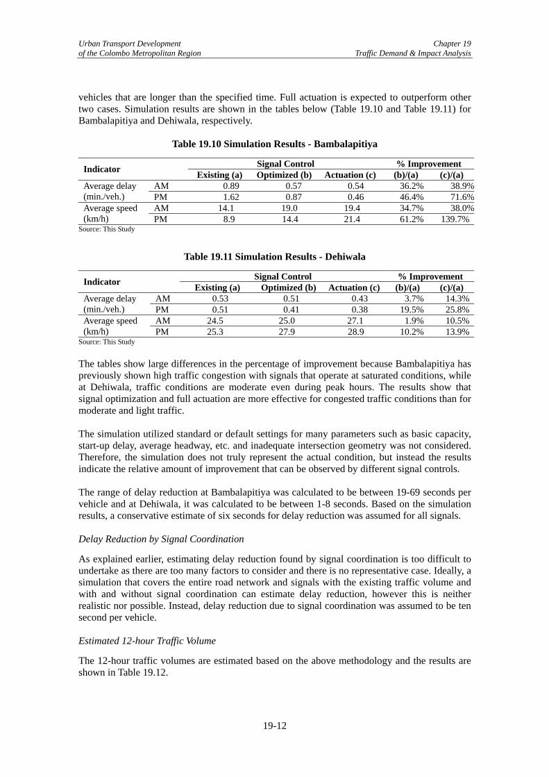
Urban Transport Development Chapter 19 of the Colombo Metropolitan Region Traffic Demand & Impact Analysis
vehicles that are longer than the specified time. Full actuation is expected to outperform other two cases. Simulation results are shown in the tables below (Table 19.10 and Table 19.11) for Bambalapitiya and Dehiwala, respectively.
Table 19.10 Simulation Results - Bambalapitiya
Signal Control % Improvement Indicator Existing (a) Optimized (b) Actuation (c) (b)/(a) (c)/(a) AM 0.89 0.57 0.54 36.2% 38.9%Average delay
(min./veh.) PM 1.62 0.87 0.46 46.4% 71.6%AM 14.1 19.0 19.4 34.7% 38.0%Average speed
(km/h) PM 8.9 14.4 21.4 61.2% 139.7%Source: This Study
Table 19.11 Simulation Results - Dehiwala
Signal Control % Improvement Indicator Existing (a) Optimized (b) Actuation (c) (b)/(a) (c)/(a) AM 0.53 0.51 0.43 3.7% 14.3%Average delay
(min./veh.) PM 0.51 0.41 0.38 19.5% 25.8%AM 24.5 25.0 27.1 1.9% 10.5%Average speed
(km/h) PM 25.3 27.9 28.9 10.2% 13.9%Source: This Study The tables show large differences in the percentage of improvement because Bambalapitiya has previously shown high traffic congestion with signals that operate at saturated conditions, while at Dehiwala, traffic conditions are moderate even during peak hours. The results show that signal optimization and full actuation are more effective for congested traffic conditions than for moderate and light traffic. The simulation utilized standard or default settings for many parameters such as basic capacity, start-up delay, average headway, etc. and inadequate intersection geometry was not considered. Therefore, the simulation does not truly represent the actual condition, but instead the results indicate the relative amount of improvement that can be observed by different signal controls. The range of delay reduction at Bambalapitiya was calculated to be between 19-69 seconds per vehicle and at Dehiwala, it was calculated to be between 1-8 seconds. Based on the simulation results, a conservative estimate of six seconds for delay reduction was assumed for all signals. Delay Reduction by Signal Coordination
As explained earlier, estimating delay reduction found by signal coordination is too difficult to undertake as there are too many factors to consider and there is no representative case. Ideally, a simulation that covers the entire road network and signals with the existing traffic volume and with and without signal coordination can estimate delay reduction, however this is neither realistic nor possible. Instead, delay reduction due to signal coordination was assumed to be ten second per vehicle. Estimated 12-hour Traffic Volume
The 12-hour traffic volumes are estimated based on the above methodology and the results are shown in Table 19.12.
19-12

Urban Transport Development Chapter 19 of the Colombo Metropolitan Region Traffic Demand & Impact Analysis
Table 19.12 Estimated 12-hour Traffic Volume at ATC signals Street Type Estimated 12-hour volume (PCU/12-hour)
Main Street 2,873,000 Cross Street 1,097,000 Total 3,970,000 Source: JICA Study Team
Estimated Annual Time Savings
Based on the figures above, annual time savings are estimated as shown in Table 19.13.9 Annual time savings are estimated to be 4.82 million hours per year.
Table 19.13 Estimated Annual Time Savings Traffic volume (000
PCU/12 hours) Delay reduction by optimization (sec)
Delay reduction by coordination (sec)
Total reduction (000 hours/ year)
Main Street 2,873 6 10 4,213 Cross Street 1,097 6 NA 603 Total 3,970 4,816
Source: JICA Study Team (2) Assessment of Impacts of Individual Flyovers Estimation Process
Time savings of the proposed flyovers were calculated using microscopic traffic simulation model for all flyovers except the Kelani Railway Flyover. The process for calculating time savings is shown in Figure 19.9. For the Kelani Railway Flyover, empirical analysis was used to estimate the time savings, which is explained below. In both cases, time savings were defined as travel time savings that would be realized by adding a flyover as compared with the case of travel time without a flyover. Other impacts, such as the reduction in accidents at at-grade intersections were not considered, although such impacts are possible due to reductions in traffic congestion.
9 One year is assumed be 330 days.
19-13

Urban Transport Development Chapter 19 of the Colombo Metropolitan Region Traffic Demand & Impact Analysis
START
Estimated peak hour turning movement volume in years 2013 & 2030 (with & without flyover)
Intersection traffic movement simulation by NETSIM (4 cases/intersection)
Formation of road network model around flyover
Comparison of with and without flyover cases and estimation of
time saving by flyover
End
Estimation of intersection total volume in years 2013 & 2030 by
STRADAIntersection turning
movement count data
Annual total time saving
Figure 19.9 Flyover Time Savings Estimation Process
Assumptions & Existing Conditions
Simulation Model NETSIM, a microscopic simulation program, was used to simulate the movement of each individual vehicle on the road network. It is a subset of Traffic Software Integrated System (TSIS), a traffic simulation software package developed by the US Federal Highway Administration. Both signalized and unsignalized intersections can be modeled. Performance indicators such as total travel time, delay time, number of vehicles in the queue, fuel consumption, and emissions are summarized and output at the end of the simulation.
Road Network To simulate the flyovers, the road network around the proposed flyover was formulated. A simple four leg network was created for Armour Street, Orugodawatta and Kohuwala flyovers. For Borella/Kanata and Rajagiriya, a more complicated network was needed as the flyovers encompass more than one intersection. Each road section was expressed by directional links and link parameters such as length, number of lanes, startup delay, discharge headway, free-flow speed, etc. were defined and input into the model. Target Years The simulation was made for 2013, the expected completion year, and 2030. Traffic Volume Total intersection volume was estimated using the network model from STRADA for 2013 and 2030. Although the network model can produce link volumes, only the intersection’s daily total volume was used for the simulation and existing movement patterns obtained through traffic
19-14

Urban Transport Development Chapter 19 of the Colombo Metropolitan Region Traffic Demand & Impact Analysis
surveys were applied to distribute the total volume to each approach and determine turning movement ratios. This is because a network model does not consider an intersection’s vehicle movements; it is better suited to road and transport planning that covers a wide area rather than an individual intersection. The same intersection total volumes were used for the two cases with flyover and without flyover in order to compare the effects of constructing flyovers. It is possible that traffic conditions will improve if flyover is constructed and that additional traffic will be induced, although the simulation did not consider this. Daily total volume is converted to peak hour volume by applying the volume ratio of the peak hour against daily volume. NETSIM has only two vehicle types - passenger car and large vehicle. So, motorcycles and three-wheelers were converted to passenger cars by applying a passenger car unit, while buses and trucks were expressed as a percent of large vehicles in the simulation. Note that at some flyovers, traffic volume used in the simulation model was reduced from the estimated volume because the simulation indicated that there would be a queue beyond the preceding intersection (spillback). Traffic Signals Traffic signal operation was also simulated in the model for all cases, including Kohuwala intersection, which is currently an unsignalized intersection. Signal phases and timings were designed and adjusted to control the traffic demand in such a way that congestion levels on all approaches were similar. Simulation Cases For each flyover, a simulation was run for four cases as shown below. Each case was run for fifteen minutes after the network reached equilibrium.
Table 19.14 Simulation Cases
Year 2013 Year 2030 Without Flyover X X With Flyover X X
Delay Time NETSIM outputs various performance indicators, such as the average delay time per vehicle. This is the difference in travel times between the cases of free-flow speeds and actual speeds and the output was used to estimate time savings. The difference in the average delay for the with flyover and without flyover cases is the time savings realized by constructing the flyover. The delay time was multiplied by the daily total volume of the intersection during the peak period, which was estimated to be between 60-80% of the total daily traffic by examining the daily traffic volume pattern. Annual Time Savings The daily delay savings were converted to annual time savings by multiplying the daily savings by 330 days. Kelani Railway Flyover
Unlike the other flyovers, in order to estimate time savings for the Kelani Railway Flyover, an empirical approach was taken and the delay per gate closure calculated. The estimation procedure adopted is described below.
19-15
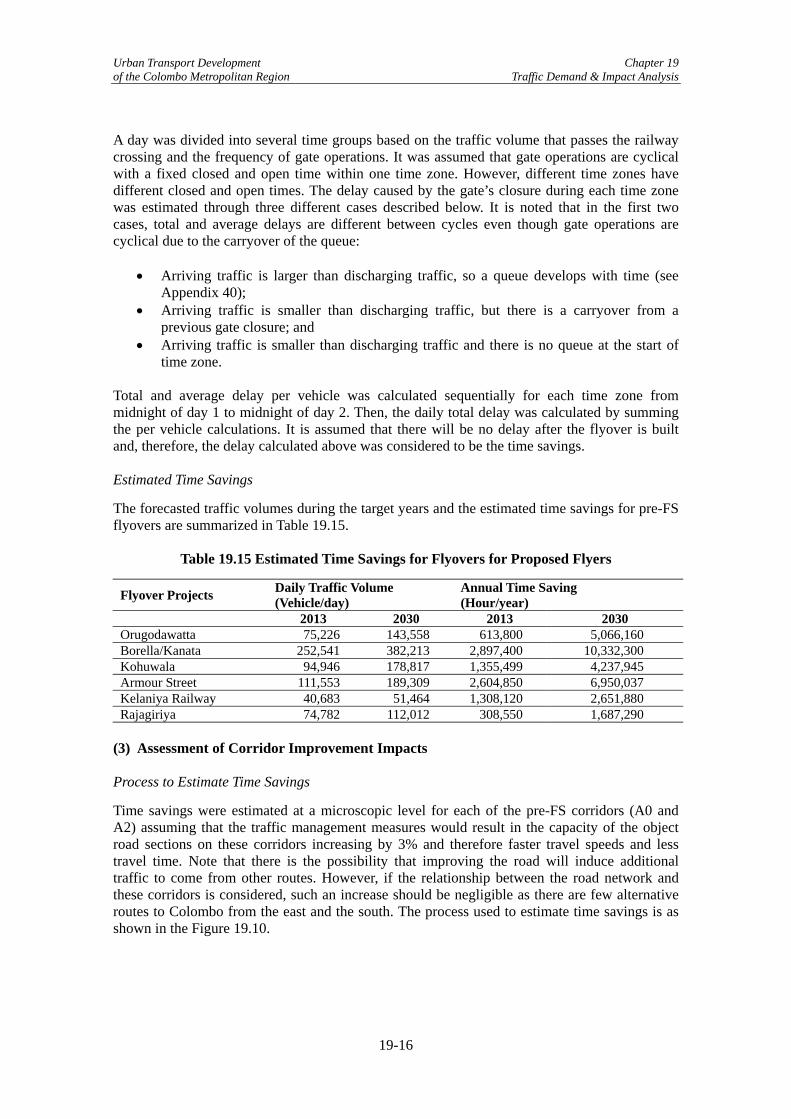
Urban Transport Development Chapter 19 of the Colombo Metropolitan Region Traffic Demand & Impact Analysis
A day was divided into several time groups based on the traffic volume that passes the railway crossing and the frequency of gate operations. It was assumed that gate operations are cyclical with a fixed closed and open time within one time zone. However, different time zones have different closed and open times. The delay caused by the gate’s closure during each time zone was estimated through three different cases described below. It is noted that in the first two cases, total and average delays are different between cycles even though gate operations are cyclical due to the carryover of the queue:
• Arriving traffic is larger than discharging traffic, so a queue develops with time (see Appendix 40);
• Arriving traffic is smaller than discharging traffic, but there is a carryover from a previous gate closure; and
• Arriving traffic is smaller than discharging traffic and there is no queue at the start of time zone.
Total and average delay per vehicle was calculated sequentially for each time zone from midnight of day 1 to midnight of day 2. Then, the daily total delay was calculated by summing the per vehicle calculations. It is assumed that there will be no delay after the flyover is built and, therefore, the delay calculated above was considered to be the time savings. Estimated Time Savings
The forecasted traffic volumes during the target years and the estimated time savings for pre-FS flyovers are summarized in Table 19.15.
Table 19.15 Estimated Time Savings for Flyovers for Proposed Flyers
Flyover Projects Daily Traffic Volume (Vehicle/day)
Annual Time Saving (Hour/year)
2013 2030 2013 2030 Orugodawatta 75,226 143,558 613,800 5,066,160 Borella/Kanata 252,541 382,213 2,897,400 10,332,300 Kohuwala 94,946 178,817 1,355,499 4,237,945 Armour Street 111,553 189,309 2,604,850 6,950,037 Kelaniya Railway 40,683 51,464 1,308,120 2,651,880 Rajagiriya 74,782 112,012 308,550 1,687,290
(3) Assessment of Corridor Improvement Impacts Process to Estimate Time Savings
Time savings were estimated at a microscopic level for each of the pre-FS corridors (A0 and A2) assuming that the traffic management measures would result in the capacity of the object road sections on these corridors increasing by 3% and therefore faster travel speeds and less travel time. Note that there is the possibility that improving the road will induce additional traffic to come from other routes. However, if the relationship between the road network and these corridors is considered, such an increase should be negligible as there are few alternative routes to Colombo from the east and the south. The process used to estimate time savings is as shown in the Figure 19.10.
19-16

Urban Transport Development Chapter 19 of the Colombo Metropolitan Region Traffic Demand & Impact Analysis
START
Amount of daily delay reduction by improvement works
Corridor traffic simulation with and without improvements for typical
traffic condition
End
Annual time savings
Figure 19.10 Process to Estimate Time Savings for Corridor Improvements
Estimated Annual Time Savings
Estimated time savings for the two corridors is summarized in Table 19.16.
Table 19.16 Annual Time Savings by Corridor Improvement
Corridor Daily Traffic Volume (vehicle/day)
Annual Time Savings (hour/year)
2013 2030 2013 2030 A2 Galle Road 42,700 64,000 79,043 127,950 A0 Sri Jayawardenepura 59,800 89,600 110,698 179,130 Source: This Study (4) Assessment of Impacts of Other Scenarios The remaining pre-FS project scenarios (which include when all flyovers and all projects are constructed) are evaluated using STRADA for the target years of 2013, 2025, and 2030. The results are in daily PCU-kilometers, PCU-hours, average network congestion (volume/capacity ratio), and average network travel speed and are shown in Tables 19.17, 19.18, and 19.19, respectively.10
Table 19.17 Impacts of Improvement Scenarios in 2013
Scenario PCU-km (million)
PCU-hr (thousand)
Daily Average V/C Ratio1)
Daily Average Speed (km/h)
-Without Case- 19.78 594.2 0.62 33.3 2. Flyover Program 19.73 594.5 0.62 33.2 4. Road Widening Program I 19.73 590.4 0.61 33.4 5. Road Widening Program II 19.73 590.4 0.61 33.4 6. B152 and B452 Road Widening 19.76 593.0 0.62 33.3 7. Koskadwila-Thalawatugoda-Pannipitiya-Tumbowila Road Widening
19.74 591.5 0.62 33.4
10 PCU means passenger car unit and the PCU values by vehicle type used in this Study are as follows: car = 1.00; 3-wheeler = 0.75; motorcycle = 0.50; bus = 1.91; truck = 1.65. PCU is used as a unit of measurement by STRADA, which is converted to vehicles in Chapter 23 in order to carry out economic analysis, as vehicle-specific measurements instead of a single integrated unit are required.
19-17

Urban Transport Development Chapter 19 of the Colombo Metropolitan Region Traffic Demand & Impact Analysis
8. With Marine Drive Extension Project 19.65 589.2 0.61 33.4
9. All Project Improvement Program I2)
19.69 587.0 0.61 33.5
10. All Project Implementation Program II3)
19.71 588.5 0.61 33.5
1) V/C means volume/capacity 2), 3) The impacts of ATC and small-scale corridor improvements are not included (see (1) and (3) of 19.7)
Table 19.18 Impacts of Improvement Scenarios in 2025
Scenario PCU-km (million)
PCU-hr (thousand)
Daily Average V/C Ratio1)
Daily Average Speed (km/h)
-Without Case- 30.00 1.075 0.94 27.9 2. Flyover Program 30.14 1.077 0.94 28.0 4. Road Widening Program I 29.95 1.067 0.93 28.1 5. Road Widening Program II 29.95 1.067 0.93 28.1 6. B152 and B452 Road Widening 29.95 1.070 0.94 28.0
7. Koskadwila-Thalawatugoda-Pannipitiya-Tumbowila Road Widening
29.94 1.072 0.93 27.9
8. With Marine Drive Extension Project 30.13 1.071 0.94 28.1
9. All Project Improvement Program I2)
29.93 1.064 0.93 28.1
10. All Project Implementation Program II3)
30.11 1.081 0.94 27.8
1) V/C means volume/capacity 2), 3) The impacts of ATC and small-scale corridor improvements are not included (see (1) and (3) of 19.7)
Table 19.19 Impacts of Improvement Scenarios in 2030
Scenario PCU-km (million)
PCU-hr (thousand)
Daily Average V/C Ratio1)
Daily Average Speed (km/h)
-Without Case- 35.24 1.398 1.10 25.2 2. Flyover Program 35.59 1.410 1.12 25.2 4. Road Widening Program I 35.06 1.373 1.09 25.5 5. Road Widening Program II 35.06 1.374 1.09 25.5 6. B152 and B452 Road Widening 35.28 1.386 1.10 25.5
7. Koskadwila-Thalawatugoda-Pannipitiya-Tumbowila Road Widening
35.18 1.379 1.10 25.5
8. With Marine Drive Extension Project 35.49 1.396 1.11 25.4
9. All Project Improvement Program I2)
35.49 1.388 1.10 25.6
10. All Project Implementation Program II3)
35.40 1.386 1.10 25.5
1) V/C means volume/capacity 2), 3) The impacts of ATC and small-scale corridor improvements are not included (see (1) and (3) of 19.7) The conclusions that can be drawn from the above tables regarding the impacts of the pre-FS project packages (Scenarios 2 to 10) in comparison to the Without Case are as follows:
19-18

Urban Transport Development Chapter 19 of the Colombo Metropolitan Region Traffic Demand & Impact Analysis
• Even with the construction of all of the proposed flyovers, positive impacts on the road network using STRADA are either undetectable or insignificant over time. Given this, the impacts of each flyover should be referred to (see (2) of 19.7);
• The construction of the Marine Drive extension (Scenario 8) contributes on a steady basis to reductions in PCU-hr and therefore to small increases in speed. On the other hand, except for the initial base year, the Marine Drive extension does not reduce PCU-km and it can be said that this improvement scenario will not contribute to reductions in vehicle operating costs;
• Implementing all road widening projects (Scenario 4) indicates that this package of projects would have the most significant impact on reducing both PCU-km and PCU-hr.
• Implementation of the two road widening Scenarios 6 and 7 also indicate that there would be reductions on the whole in PCU-km and PCU-km as well. Although, there is the anomaly of PCU-km for Scenario 6 in 2030 being higher than that for the Without Case scenario and is difficult to explain.
• As land acquisition costs for the Nugegoda-Pepiliyana Road widening project are expected to be high and will therefore have an adverse impact on the feasibility of Scenario 4 as a whole, Scenario 5 excluded this project and recalculated the traffic evaluation indices. As the above tables indicate, the exclusion of this project does not adversely affect the reduction in PCU-km or PCU-hr.
• With the implementation of all the pre-FS projects (Scenario 9)11, there are again in comparison to the Without Case reductions in all the target years regarding PCU-km and PCU-hr, expect for PCU-km in the year 2030, which is thought to be due to the particular combination of different projects.
• As the flyover construction and Marine Drive extension packages do not have a positive impact on the reduction of PCU-km, Scenario 10 excluded these and recalculated the traffic evaluation indices. As the above tables show, in comparison to Scenario 9, there was only an improvement in the reduction in total distance traveled and total travel time in the target year of 2030, while Scenario 9 experienced greater decreases in PCU-km and PCU-hr in comparison to the Without Case for the other years of 2013 and 2025.
• Although the reduction in congestion and therefore the increase in travel speed for a scenario can seem small from the perspective of an individual vehicle, aggregate savings in distance traveled and time expended is not insignificant.
11 The evaluation here does not include the ATC system as it was modelled utilizing the software package NetSim
19-19

Urban Transport Development Chapter 19 of the Colombo Metropolitan Region Traffic Demand & Impact Analysis
19-20