chapter 1 purpose and need for east link ... - sound transit...chapter 1 purpose and need for east...
TRANSCRIPT

East Link Project Final EIS 1-1 1.0 Purpose and Need for East Link Project July 2011
Chapter 1
Purpose and Need for East Link Project
1.1 Purpose of the Project The purpose of the East Link Project is to expand the Sound Transit Link light rail system from Seattle to Mercer Island, Bellevue and Redmond via Interstate 90 (I-90) and to provide a reliable and efficient alternative for moving people throughout the region.
1.1.1 Project Vicinity The project corridor is located in King County, Washington, the most densely populated county of the Puget Sound region. The project vicinity includes urban centers on both sides of Lake Washington (Exhibit 1-1). The project corridor originates at the Downtown Seattle Transit Tunnel at the International District/Chinatown Station, and then travels eastward on I-90 to the Rainier Valley Neighborhood before entering the Mount Baker Tunnel and crossing Lake Washington on the I-90 Floating Bridge to the Mercer Island Town Center. It remains on I-90, crossing the East Channel Bridge to the City of Bellevue. The project corridor extends north from I-90 between Bellevue Way and the I-405/former BNSF Railway corridor toward Downtown Bellevue. From Downtown Bellevue, the project corridor extends east, parallel to State Route (SR) 520 through Bellevue’s
Bel-Red subarea and Overlake, a subarea in the City of Redmond. From Overlake, the project corridor continues northeast parallel to SR 520 to Downtown Redmond, which is the terminus of the project.
1.1.2 Support for Project Purpose The purpose of the East Link Project is based upon over 40 years of continuous and cooperative regional and local transportation planning. The research, joint planning efforts, and decision-making processes are recorded in East Corridor High-Capacity Transit Mode Analysis History (Sound Transit, 2006) and summarized in Section 1.3 of this chapter. The conclusions and findings from that history were used to develop the following support for the East Link Project purpose:
• Improve speed and reliability and expand the region’s transportation system capacity through an exclusive light rail transit right-of-way, while preserving the environment.
• Increase mobility and accessibility to and from the region’s highest employment and housing concentrations.
EXHIBIT 1-1 East Link Project Vicinity Map

Chapter 1 Purpose and Need for East Link Project
1.0 Purpose and Need for East Link Project 1-2 East Link Project Final EIS July 2011
• Support regional land use and transportation plans—VISION 2040 (Puget Sound Regional Council [PSRC], 2009) and Transportation 2040 (PSRC, 2010)—to direct growth into high-density urban and manufacturing centers in Downtown Bellevue, Overlake, and Redmond by providing a high-capacity transit (HCT) connection between these centers, Seattle, and other regional destinations.
• Implement the goals and objectives identified in Sound Transit’s Long-Range Plan (Sound Transit, 2005), which guides the development of the regional HCT system. The main transportation goal is to “provide a public transportation system that helps ensure long-term mobility, connectivity, and convenience for the citizens of the Puget Sound Region for generations to come” and to “provide reliable, convenient, and safe public transportation services between regional growth centers and create an integrated system of transit services.”
• Implement the HCT element of the Washington State Department of Transportation (WSDOT) I-90 Two-Way Transit and High Occupancy Vehicle (HOV) Operations Project Final Environmental Impact Statement (EIS) (WSDOT and Sound Transit, 2004); the Federal Highway Administration (FHWA) Record of Decision (FHWA, 2004); the Federal Transit Administration (FTA) Record of Decision (April 15, 2011); and the August 2004 Amendment to the 1976 Memorandum Agreement between King County, City of Bellevue, City of Seattle, City of Mercer Island, Washington State Transportation Commission, and Sound Transit (City of Mercer Island et al., 2004). These documents stipulate that the ultimate configuration of I-90 should accommodate all phases of the I-90 Two-Way Transit and HOV Operations Project with HCT in the center lanes. The amendment directs the agencies “to provide high-capacity transit in the center lanes of I-90 between Bellevue and Seattle as quickly as possible...” The amendment and Final EIS define HCT as “… a transit system operating in dedicated right-of-way, such as light rail, monorail, or a substantially equivalent system.”
• More fully develop a regional transit system that would integrate with the Central Link light rail line, providing direct connections among the largest urban centers in King County.
• Fulfill Sound Transit’s legislative mandate to meet public transportation and mobility needs for HCT infrastructure in the Central Puget Sound region, as established by the State High-Capacity
Transportation Systems Act (Ch. 81.104 Revised Code of Washington).
1.2 Need for East Link Project Current and projected population and employment trends reveal a need to provide light rail transit between Seattle and the Bellevue and Redmond urban centers. This section explains why existing transit will not be able to serve the future transit needs in the project corridor. In brief, these reasons are as follows:
• Increased demand for transit services across Lake Washington is expected to double by 2030 as a result of residential and employment growth on both sides of Lake Washington.
• Regional urban center growth plans supported by HCT investments in accordance with PSRC’s adopted Transportation 2040.
• Increased congestion on I-90 will further limit transit performance as the I-90 corridor reaches maximum vehicle capacity during peak-hour travel as early as 2015 (WSDOT, 2006).
• Operating deficiencies in regional bus transit service will continue to occur due to lower speeds and decreasing reliability.
• Limited transit capacity and connectivity between the areas of highest employment density in the region will occur due to constraints of the current road system.
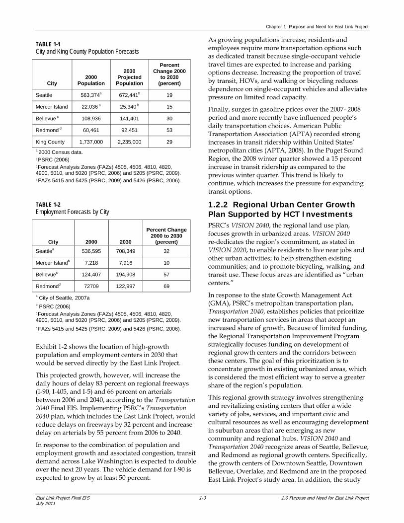
1.2.1 Growth and Increased Demand for Transit Services Regional planning for growth and transportation is conducted by PSRC, the metropolitan planning organization for the Puget Sound region, which includes King, Kitsap, Pierce, and Snohomish Counties. Population and employment growth in this region is strong. Rapid population and employment growth in the Puget Sound region in recent decades has exceeded national averages (PSRC, 2006). Between 2000 and 2030, PSRC projections show that the region’s population will increase almost 40 percent (an additional 1.3 million people). Corridor-specific population projections are shown in Table 1-1.
Regional employment will grow approximately 42 percent (more than 737,000 new jobs); Table 1-2 lists city-specific employment projections. More than 30 percent of the region’s employment is in the Downtown Seattle, Bellevue, and Redmond growth centers, and regional planning has focused new housing and employment growth within these urban areas.
Chapter 1 Purpose and Need for East Link Project
East Link Project Final EIS 1-3 1.0 Purpose and Need for East Link Project July 2011
TABLE 1-1 City and King County Population Forecasts
City 2000
Population
2030 Projected
Population
Percent Change 2000
to 2030 (percent)
Seattle 563,374a 672,441b 19
Mercer Island 22,036 a 25,340 b 15
Bellevue c 108,936 141,401 30
Redmond d 60,461 92,451 53
King County 1,737,000 2,235,000 29
a 2000 Census data. b PSRC (2006) c Forecast Analysis Zones (FAZs) 4505, 4506, 4810, 4820, 4900, 5010, and 5020 (PSRC, 2006) and 5205 (PSRC, 2009). d FAZs 5415 and 5425 (PSRC, 2009) and 5426 (PSRC, 2006).
Exhibit 1-2 shows the location of high-growth population and employment centers in 2030 that would be served directly by the East Link Project.
This projected growth, however, will increase the daily hours of delay 83 percent on regional freeways (I-90, I-405, and I-5) and 66 percent on arterials between 2006 and 2040, according to the Transportation 2040 Final EIS. Implementing PSRC’s Transportation 2040 plan, which includes the East Link Project, would reduce delays on freeways by 32 percent and increase delay on arterials by 55 percent from 2006 to 2040.
In response to the combination of population and employment growth and associated congestion, transit demand across Lake Washington is expected to double over the next 20 years. The vehicle demand for I-90 is expected to grow by at least 50 percent.
As growing populations increase, residents and employees require more transportation options such as dedicated transit because single-occupant vehicle travel times are expected to increase and parking options decrease. Increasing the proportion of travel by transit, HOVs, and walking or bicycling reduces dependence on single-occupant vehicles and alleviates pressure on limited road capacity.
Finally, surges in gasoline prices over the 2007- 2008 period and more recently have influenced people’s daily transportation choices. American Public Transportation Association (APTA) recorded strong increases in transit ridership within United States’ metropolitan cities (APTA, 2008). In the Puget Sound Region, the 2008 winter quarter showed a 15 percent increase in transit ridership as compared to the previous winter quarter. This trend is likely to continue, which increases the pressure for expanding transit options.
1.2.2 Regional Urban Center Growth Plan Supported by HCT Investments PSRC’s VISION 2040, the regional land use plan, focuses growth in urbanized areas. VISION 2040 re-dedicates the region’s commitment, as stated in VISION 2020, to enable residents to live near jobs and other urban activities; to help strengthen existing communities; and to promote bicycling, walking, and transit use. These focus areas are identified as “urban centers.”
In response to the state Growth Management Act (GMA), PSRC’s metropolitan transportation plan, Transportation 2040, establishes policies that prioritize new transportation services in areas that accept an increased share of growth. Because of limited funding, the Regional Transportation Improvement Program strategically focuses funding on development of regional growth centers and the corridors between these centers. The goal of this prioritization is to concentrate growth in existing urbanized areas, which is considered the most efficient way to serve a greater share of the region’s population.
This regional growth strategy involves strengthening and revitalizing existing centers that offer a wide variety of jobs, services, and important civic and cultural resources as well as encouraging development in suburban areas that are emerging as new community and regional hubs. VISION 2040 and Transportation 2040 recognize areas of Seattle, Bellevue, and Redmond as regional growth centers. Specifically, the growth centers of Downtown Seattle, Downtown Bellevue, Overlake, and Redmond are in the proposed East Link Project’s study area. In addition, the study
TABLE 1-2 Employment Forecasts by City
City 2000 2030
Percent Change 2000 to 2030
(percent)
Seattlea 536,595 708,349 32
Mercer Islandb 7,218 7,916 10
Bellevuec 124,407 194,908 57
Redmondd 72709 122,997 69
a City of Seattle, 2007a b PSRC (2006) c Forecast Analysis Zones (FAZs) 4505, 4506, 4810, 4820, 4900, 5010, and 5020 (PSRC, 2006) and 5205 (PSRC, 2009). d FAZs 5415 and 5425 (PSRC, 2009) and 5426 (PSRC, 2006).

Chapter 1 Purpose and Need for East Link Project
1.0 Purpose and Need for East Link Project 1-4 East Link Project Final EIS July 2011
area includes connections to identified urban centers that are going to be served by the completion of Central Link, such as Capitol Hill, the University District, and the airport.
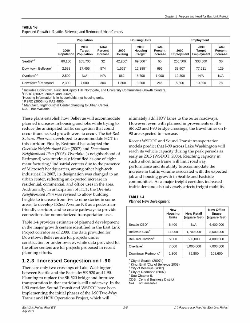
Today, Redmond and Bellevue are rapidly developing and expanding, causing them to approach density goals (targets) earlier than expected and increasing the pressure to implement efficient transportation alternatives to improve connections between these regional urban centers (Table 1-3). By 2000, the Downtown Bellevue regional growth center had reached 60 percent of its population target, 64 percent of its housing target, and 75 percent of its employment target for 2030. The (Downtown) Redmond regional growth center had reached 32 percent of its population target, 41 percent of its housing target, and 56 percent of its employment target for 2030. With ongoing development, Bellevue and Redmond are on track to meet their targets by 2030 or earlier.
Seattle, Mercer Island, Bellevue, and Redmond have adopted or are adopting plans to create concentrated centers of high-density, mixed-use, pedestrian-scale
development, based upon the assumption that they would receive HCT to support changing transportation needs. Methods to increase density and promote nonmotorized transportation in these plans include increasing maximum building height; requiring sidewalks; limiting parking availability; and integrating multiple land uses such as residential, commercial, office, and public spaces. In Seattle, the Center City Seattle (2007c) strategy identifies 10 specific neighborhoods within the city that will represent a new urban identity for Seattle’s urban core, while creating jobs and providing economic opportunities. One of those neighborhoods, the International District/Chinatown, would be directly served by the East Link Project, while others such as Capitol Hill, Pike/Pine, First Hill, and the Commercial Core would be served through connections to Central Link.
Mercer Island’s comprehensive plan seeks to maintain the city primarily as a community of single-family homes and focuses mixed-use growth in the Town Center adjacent to I-90. Bellevue has adopted the Downtown Subarea Plan (2004) and Bel-Red Subarea Plan (2008).
EXHIBIT 1-2 Location of High-Growth Employment and
Population Centers in East Link Corridor
Chapter 1 Purpose and Need for East Link Project
East Link Project Final EIS 1-5 1.0 Purpose and Need for East Link Project July 2011
TABLE 1-3 Expected Growth in Seattle, Bellevue, and Redmond Urban Centers
Population Housing Units Employment
2000 Population
2030 Target
Population
Total Percent Increase
2000 Housing
2030 Housing Target
Total Percent Increase
2000 Employment
2030 Target
Employment
Total Percent Increase
Seattlea,b 80,100 105,700 32 42,200c 69,500 c 65 256,500 333,500 30
Downtown Bellevued 2,588 17.456 574 1,559c 12,388 c 695 33,907 77,511 129
Overlakec,b 2,500 N/A N/A 862 8,700 1,000 19,300 N/A N/A
Downtown bRedmond 2,300 7,000 304 1,300 3,200 246 5,800 10,300 78
a Includes Downtown, First Hill/Capitol Hill, Northgate, and University Communities Growth Centers. bPSRC (2002a, 2002b, and 2002c). cHousing information is in households, not housing units. d PSRC (2006) for FAZ 4900. e Manufacturing/Industrial Center changing to Urban Center. N/A not available
These plans establish how Bellevue will accommodate planned increases in housing and jobs while trying to reduce the anticipated traffic congestion that could occur if unchecked growth were to occur. The Bel-Red Subarea Plan was developed to accommodate HCT in this corridor. Finally, Redmond has adopted the Overlake Neighborhood Plan (2007) and Downtown Neighborhood Plan (2005). Overlake (a neighborhood of Redmond) was previously identified as one of eight manufacturing/ industrial centers due to the presence of Microsoft headquarters, among other high-tech industries. In 2007, its designation was changed to an urban center, reflecting an expected increase in residential, commercial, and office uses in the area. Additionally, in anticipation of HCT, the Overlake Neighborhood Plan was revised to allow building heights to increase from five to nine stories in some areas, to develop 152nd Avenue NE as a pedestrian-friendly corridor, and to create pathways to provide connections for nonmotorized transportation uses.
Table 1-4 provides estimates of planned development in the major growth centers identified in the East Link Project corridor as of 2008. The data provided for Downtown Bellevue are for projects under construction or under review, while data provided for the other centers are for projects proposed in recent planning efforts.
1.2.3 Increased Congestion on I-90 There are only two crossings of Lake Washington between Seattle and the Eastside: SR 520 and I-90. Planning to replace the SR 520 bridge and improve transportation in that corridor is still underway. In the I-90 corridor, Sound Transit and WSDOT have been implementing the initial phases of the I-90 Two-Way Transit and HOV Operations Project, which will
ultimately add HOV lanes to the outer roadways. However, even with planned improvements on the SR 520 and I-90 bridge crossings, the travel times on I-90 are expected to increase.
Recent WSDOT and Sound Transit transportation models predict that I-90 across Lake Washington will reach its vehicle capacity during the peak periods as early as 2015 (WSDOT, 2006). Reaching capacity in such a short time frame will limit roadway performance and its ability to accommodate the increase in traffic volume associated with the expected job and housing growth in Seattle and Eastside communities. As a major freight corridor, increased traffic demand also adversely affects freight mobility.
TABLE 1-4 Planned New Development
New Housing
Units New Retail
(square feet)
New Office Space
(square feet)
Seattle CBDa 8,400 N/A 6,400,000
Bellevue CBDb 11,000 1,700,000 8,600,000
Bel-Red Corridorc 5,000 500,000 4,000,000
Overlaked 7,000 5,000,000 7,000,000
Downtown Redmonde 1,300 75,800 108,600
a City of Seattle (2007b) b King, Emil (City of Bellevue 2008) c City of Bellevue (2007) d City of Redmond (2007) e See Chapter 5. CDB Central Business District N/A not available
Chapter 1 Purpose and Need for East Link Project
1.0 Purpose and Need for East Link Project 1-6 East Link Project Final EIS July 2011
Even with the roadway improvements already constructed or planned for I-90, the interchanges at I-405 and Bellevue Way on the Eastside and at I-5 in Seattle constrain I-90’s vehicle capacity. Further improvements are physically constrained by existing urban development and infrastructure.
In the morning (AM) and afternoon (PM) peak hours, the travel times that exist now are expected to get worse. By 2030, Sound Transit and WSDOT project that the PM peak hour travel time between I-405 and Seattle will increase by about 60 percent westbound (reaching 30 minutes) and by approximately 20 percent eastbound (reaching 20 minutes). In the AM peak hour, travel times are expected to increase even more substantially. In both the westbound and eastbound directions, the travel time will increase by approximately 70 percent. These increases reflect the fact that there are high-density urban centers on both sides of the lake, resulting in a more balanced commute pattern in either direction, rather than the historical pattern of commuters going to work in Seattle and living in East King County. The largest increase in travel times is forecast in the reverse-peak direction, which means that travel in both directions will become more balanced.
As with increases in travel time, the peak period of congestion on I-90 will increase by at least 1 hour in each direction. By year 2030, the duration of congestion in the westbound general-purpose lanes during the afternoon is expected to increase from 1.5 hours to 2.5 hours or longer. In the eastbound direction during the PM peak, the duration of congestion in the general-purpose lanes will increase from just over 1 hour to more than 2 hours. Congestion extending outside the peak commuting hours will negatively affect the transportation system’s reliability and its ability to serve demand, and it will further constrain the region’s mobility and movement of goods.
Even though the morning westbound and afternoon eastbound HOVs and transit on I-90 can use the reversible center roadway, which is two lanes, the capacity constraints on either end only allow it to carry the equivalent of about one lane of traffic. The center reversible roadway will continue to be underutilized in the future because of constraints in accessing these lanes, which prevents the center roadway from realizing its full capacity. However, the outer roadway is expected to reach its maximum vehicle capacity by 2015. Increased congestion will further exacerbate bus service delays.
1.2.4 Operating Deficiencies in Regional Bus Transit Service As congestion throughout the region increases, it is imperative to examine options and take action to overcome the limitations in the existing regional bus system that are caused by the lower speeds, decreasing reliability, and service capacity constraints of buses.
Reliability is defined as the degree to which transit service can be counted on for consistent, on-time performance. Current transit service in the project vicinity has poor reliability due to congestion on local arterials and I-90 (King County, 2007), and the average transit route at the International District/Chinatown Station, Mercer Island, and Bellevue Transit Center has the lowest reliability rating—level of service (LOS) F (Transportation Research Board, 2003). This reliability rating means that routes are late at least 50 percent of the time. Most transit routes at Overlake Transit Center and Redmond Transit Center also operate with LOS F.
The urban center-to-urban center express routes are Sound Transit’s Seattle to Bellevue 550 and the Seattle to Redmond 545. These express service routes feed a broader network of King County Metro buses. When the 550 and 545 are late, passenger connections are in jeopardy. Westbound Express Route 550 trips from Bellevue to the Mercer Island Transit Center are late during the peak period 50 percent of the time and when it reaches Seattle, it is late 70 percent of the time during the peak period. To avoid being late no more than twice a month, riders on this route need to build an additional 15 minutes into their daily schedule. This lack of reliability makes it difficult for users to have confidence that they will reach their destinations on time and it reduces the attractiveness of transit service throughout the project corridor.
Bus speeds from Seattle to Bellevue and from Bellevue to Redmond are projected to decrease by 30 percent or more by 2030, even assuming major I-90 infrastructure improvements (Sound Transit, 2006). Transit patronage is highly sensitive to travel time expectancy. Increasing use of HOV lanes and added congestion on the local and arterial streets in the corridor threatens to further worsen the urban center-to-urban center bus travel times. Because speeds on HOV lanes without a separating barrier are affected by congestion in adjacent lanes, transit travel time will likely mirror congestion periods, thus reducing the benefits of transit. At present, bus travel times in the corridor are typically over 30 minutes between the International District/Chinatown Station and the Bellevue Transit

Chapter 1 Purpose and Need for East Link Project
East Link Project Final EIS 1-7 1.0 Purpose and Need for East Link Project July 2011
EXHIBIT 1-3 Failing Intersections in South and Downtown
Bellevue in 2030
EXHIBIT 1-4 Failing Intersections in Bel-Red, Overlake, and
Downtown Redmond in 2030
Center in the PM peak, with an average bus speed of 16 miles per hour. By 2030, speeds on the same bus route are expected to decrease to 11 miles per hour based on Sound Transit model projections, with the bus travel time between the International District/Chinatown Station and the Bellevue Transit Center in the PM peak reaching close to an hour long (Sound Transit, 2006). If unhindered, bus travel time for this trip is expected to be less than 25 minutes.
Transit reliability and speed of travel are also currently negatively affected by congestion on arterial routes, such as Bellevue Way SE, NE 8th Street, 148th Avenue NE, and 156th Avenue NE. Within Bellevue and Redmond, several major bus routes operate on these and other arterial roads. Congestion on many of these streets is also anticipated to worsen over the next 20 years. Exhibits 1-3 and 1-4 illustrate key intersections in the project vicinity that are expected to be at or below failing conditions (LOS E or F) by 2030. These intersections affect travel on the surrounding roadways, including transit service.
The Bellevue Way and 112th Avenue SE corridors between Downtown Bellevue and I-90 are substantially congested during the PM peak period, and the congestion is expected to get worse. In particular, the intersection of Bellevue Way SE and the
South Bellevue Park-and-Ride Lot operates at LOS F, with southbound vehicle queues often extending beyond the 112th Avenue SE intersection. Sound Transit Route 550 is often caught in this afternoon congestion, which contributes considerably to the poor speed and reliability of this route. Congestion near the Wilburton Park-and-Ride Lot along SE 8th Street is also high during the PM peak period because it is near the I-405 ramps.
Within Downtown Bellevue, 10 intersections are expected to operate at LOS E or F by 2030. Many transit routes in the east corridor travel through these intersections to access the Bellevue Transit Center. Five intersections along 112th Avenue SE and four intersections along NE 8th Street are expected to operate poorly (either at LOS E or F). Congestion on these key arterials affects many of the transit routes in Downtown Bellevue, and it restricts the ability for these transit routes to maintain their schedules, affecting reliability.
The Bel-Red corridor from Downtown Bellevue to Overlake includes several intersections that operate at a LOS D or worse, and by 2030, most of the intersections in the Overlake area east of 140th Avenue NE will operate at LOS E or F, causing substantial delays to buses traveling along NE 24th Street, Bel-Red

Chapter 1 Purpose and Need for East Link Project
1.0 Purpose and Need for East Link Project 1-8 East Link Project Final EIS July 2011
Road, 148th Avenue NE, 156th Avenue NE, and NE 20th Street. These arterials serve two transit facilities in the project vicinity: Overlake Village and Overlake Transit Center. The congestion on these arterials is a result of major employment and retail centers located in this area, as well as congestion on SR 520, which forces through traffic onto these arterials. Congestion on these arterials will affect transit speeds and negatively affect reliability of routes throughout the region. Transit access to and from SR 520 is also hindered by the high traffic volumes using the interchanges at 148th Avenue NE, NE 40th Street, and NE 51st Street. Transit performance is at LOS F conditions approaching Downtown Redmond and at Redmond’s two transit centers due to transportation congestion at the SR 520 access ramps and from West Lake Sammamish Parkway and Redmond Way (SR 202). These conditions affect bus speed and reliability.
As development plans in the project vicinity encourage development of denser and more mixed uses, access and traffic constraints into and out of the urban centers will continue to hinder the ability of regional buses to meet the larger transit network needs and therefore reduce transit’s ability to provide a viable alternative to the automobile. If a more reliable system is made available, overall dependence on one mode of transportation will decrease and travel via all modes will improve, allowing the region’s urban centers to efficiently absorb growth.
1.2.5 Limited Transit Capacity and Connectivity Infrastructure constraints limit the ability of transit to meet the untapped demand for reliable daily business and commuter travel, as explained in Sections 1.2.3 and 1.2.4. Even with increases in congestion and delays, the preferred mode of travel across I-90 is not expected to substantially change from today’s preference for single-occupant vehicles to bus transit service. Because of poor connectivity and speed of travel between destinations, more than 60 percent of people using I-90 to cross Lake Washington in 2030 are projected to use single-occupant vehicles in the AM peak period and more than 50 percent in the PM peak period. Existing bus routes connecting urban centers have to use the same roadways as other vehicles and therefore cannot compete with the door-to-door service of the single-occupant vehicles unless transit can save travelers time. Furthermore, there are physical constraints to widening many of the roadways, such as I-5 and the connections between I-90 and its adjoining arterials, which are at capacity.
Bus transit capacity is also limited within the central business districts within the project vicinity. In the Seattle Downtown Transit Tunnel, bus operations will decrease and eventually be eliminated as light rail ridership on Central Link and the frequency of light rail trains increases. This will redirect buses to already congested urban surface streets in Downtown Seattle, increasing travel time and decreasing reliability for these routes. In Downtown Bellevue, the 14 transit bays at the Bellevue Transit Center currently must accommodate multiple bus routes on tight schedules during peak travel periods. Frequently, buses that are on time here must wait while delayed buses board passengers, thus causing delays for these routes as well. In addition, local arterial capacity and on-street stops will limit the ability to increase the frequency of buses. More frequent bus service may increase capacity for users, but congestion still limits travel time, which ultimately determines the ability for transit to attract passengers.
The urban center-to-urban center connections determine the effectiveness of the overall transit system. Increasing center-to-center transit service reliability would help passengers meet transit connections and make it easier to depend on transit as a viable alternative mode to the automobile. Also, adding dependable service and capacity would improve economic linkages across Lake Washington, offer increased employment-to-housing connections, and expand the functionality of the transit service in the Puget Sound Region.
1.3 Brief History of East Corridor The East Link Project builds on the conclusions of previous planning, studies, and public involvement processes dating back to the mid-1960s. Sound Transit has assembled the East Corridor High-Capacity Transit Mode Analysis History (Sound Transit, 2006) documenting the outcome of this local public transportation planning process, which forms the basis for the Purpose and Need statement for the East Link Project EIS. Consistent with the memorandum titled Integration of Planning and NEPA Processes (Appendix A to 49 Code of Federal Regulations [CFR] Part 613), the decision process is based on comprehensive studies that were completed in cooperation with state and local agencies and broad public input. In particular, the Sound Transit Board made the following two major decisions after extensive evaluation and review with other agencies and the public before beginning this East Link Project EIS:
Regional HCT to the Eastside via I–90 is necessary.

Chapter 1 Purpose and Need for East Link Project
East Link Project Final EIS 1-9 1.0 Purpose and Need for East Link Project July 2011
Light rail is the preferred HCT technology for the I–90/East Corridor connecting Seattle, Mercer Island, Bellevue, Overlake, and Redmond.
The following subsections summarize this history, the involvement of agencies and the public, and the results of the extensive study of HCT.
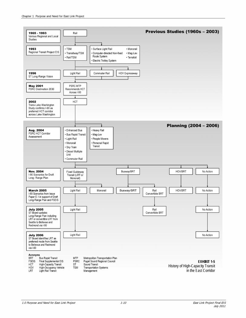
1.3.1 Evaluation of Regional HCT to the Eastside via I-90 The history of HCT in the East Corridor is illustrated at a glance in Exhibit 1-5. Although local jurisdictions had earlier reviewed HCT options for regional travel, the first official public action was sought in 1968. A bond measure proposing an extensive rail system for King County was put to voters in 1968 and again in 1970. The measures received support but did not pass.
The State of Washington, local jurisdictions, and transit agencies have been involved in studying transit options across Lake Washington. In 1976, after extensive review and discussion, a memorandum agreement for I–90 was signed by the Cities of Seattle, Mercer Island, and Bellevue; King County; Metro Transit; and the State Highway Commission that confirmed the configuration of the I-90 roadway and specified that the I–90 center roadway should be designed and constructed for future conversion to fixed guideway transit (i.e., rail). (City of Seattle et al., 1976).
In 1981, PSRC (formerly the Puget Sound Council of Governments [PSCOG]) conducted a study to evaluate and prioritize major corridors for HCT in the Puget Sound region for 1990 and beyond. The East corridor from the Seattle Central Business District across I–90 to northeast Bellevue was ranked second highest, with only the north corridor from the Seattle Central Business District to Snohomish County ranking higher (PSCOG, 1981). The Regional Transportation Plan Update (PSCOG, 1982) was amended in September 1982 to include this prioritization. It stated that, because of high peak-period volumes projected in the major corridors, an HCT system would be required to serve high volumes of people, and it identified light rail as a feasible alternative.
In the 1990s, in response to an advisory ballot measure passed by King County voters, the region began the planning work associated with developing a regional HCT system. In August 1990, a regional planning entity, the Joint Regional Policy Committee (JRPC), was formed through an interlocal agreement among the transit agencies of Pierce, King, and Snohomish Counties to coordinate regional transit planning (consistent with Chapter 81.104 Revised Code of Washington [RCW]).
Four broad regional HCT system plan alternatives were evaluated in an EIS, including a no-build alternative, a transportation systems management (TSM) alternative, an exclusive bus transitway/TSM option, and a rail/TSM option. In 1993, following approximately 4 years of study and extensive public involvement, the JRPC identified rail/TSM as the preferred system alternative and, specifically, rail as the preferred HCT mode on I–90. Next, with approval by the Snohomish, King, and Pierce county councils, the Central Puget Sound Regional Transit Authority (RTA), now known as Sound Transit, was formed later in 1993 (consistent with Chapter 81.112 RCW).
In 1996, the voters approved Sound Transit’s (i.e., RTA’s) first phase of HCT investments in the regional transit investment plan called “Sound Move” (Sound Transit, 1996a). Sound Move included two-way bus transit and HOV improvements on I–90 between Seattle and Bellevue. The Sound Transit Board adopted Sound Move, along with The Regional Transit Long-Range Vision (Sound Transit, 1996b), which identified the framework for HCT investments in the region, including potential for future light rail extensions. The Long-Range Vision and Sound Move plans reflected public input on regional priorities and were consistent with Sound Transit’s enabling legislation (which explicitly identifies interim express bus service as a precursor to HCT investments) as well as the 1976 Memorandum Agreement for I–90. Concurrent with the adoption of the Regional Transit Long-Range Vision, the Sound Transit Board identified the I–90 corridor as a potential future light rail corridor.
Starting in 1998, WSDOT and Sound Transit served as co-leads on the Trans-Lake Washington Study, which identified a set of solutions to improve transportation across and/or around Lake Washington (WSDOT and Sound Transit, 2002). As part of this study, a 47-member study committee (composed of cities, public agencies, businesses, and neighborhood and advocacy groups) reaffirmed earlier decisions that had identified I–90 as the first priority for crossing Lake Washington with HCT.
As part of the implementation of Sound Move, in 2004 WSDOT, Sound Transit, and the Federal Highway Administration (FHWA) collaborated on the I–90 Two-Way Transit and HOV Operations Project. Extensive public outreach and coordination with local jurisdictions occurred during the conceptual design and environmental phase of the project, from 1998 to 2004. The Final EIS for the I–90 Two-Way Transit and HOV Operations Project was issued in May 2004 (WSDOT and Sound Transit, 2004) with a Record of Decision by FHWA in September 2004 (FHWA, 2004).
Chapter 1 Purpose and Need for East Link Project
1.0 Purpose and Need for East Link Project 1-10 East Link Project Final EIS July 2011
EXHIBIT 1-5 History of High-Capacity Transit
in the East Corridor
Chapter 1 Purpose and Need for East Link Project
East Link Project Final EIS 1-11 1.0 Purpose and Need for East Link Project July 2011
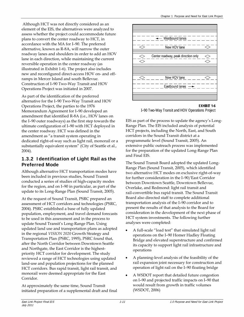
Although HCT was not directly considered as an element of the EIS, the alternatives were analyzed to assess whether the project could accommodate future plans to convert the center roadway to HCT, in accordance with the MA for I–90. The preferred alternative, known as R-8A, will narrow the outer roadway lanes and shoulders in order to add an HOV lane in each direction, while maintaining the current reversible operation in the center roadway (as illustrated in Exhibit 1-6). The project also includes new and reconfigured direct-access HOV on- and off-ramps in Mercer Island and south Bellevue. Construction of I–90 Two-Way Transit and HOV Operations Project was initiated in 2007.
As part of the identification of the preferred alternative for the I–90 Two-Way Transit and HOV Operations Project, the parties to the 1976 Memorandum Agreement for I–90 developed an amendment that identified R-8A (i.e., HOV lanes on the I–90 outer roadways) as the first step towards the ultimate configuration of I–90 with HCT deployed in the center roadway. HCT was defined in the amendment as “a transit system operating in dedicated right-of-way such as light rail, monorail or a substantially equivalent system” (City of Seattle et al., 2004).
1.3.2 Identification of Light Rail as the Preferred Mode Although alternative HCT transportation modes have been included in previous studies, Sound Transit conducted a series of studies of high-capacity modes for the region, and on I–90 in particular, as part of the update to its Long-Range Plan (Sound Transit, 2005).
At the request of Sound Transit, PSRC prepared an assessment of HCT corridors and technologies (PSRC, 2004). PSRC established a base of fully updated population, employment, and travel demand forecasts to be used in this assessment and in the process to update Sound Transit’s Long-Range Plan. Using updated land use and transportation plans as adopted in the regional VISION 2020 Growth Strategy and Transportation Plan (PSRC, 1995), PSRC found that, after the North Corridor between Downtown Seattle and Northgate, the East Corridor is the highest-priority HCT corridor for development. The study reviewed a range of HCT technologies using updated land-use and population projections for the planned HCT corridors. Bus rapid transit, light rail transit, and monorail were deemed appropriate for the East Corridor.
At approximately the same time, Sound Transit initiated preparation of a supplemental draft and final
EIS as part of the process to update the agency’s Long-Range Plan. The EIS included analysis of potential HCT projects, including the North, East, and South corridors in the Sound Transit district at a programmatic level (Sound Transit, 2005). An extensive public outreach process was implemented for the preparation of the updated Long-Range Plan and Final EIS.
The Sound Transit Board adopted the updated Long-Range Plan (Sound Transit, 2005), which identified two alternative HCT modes on exclusive right-of-way for further consideration in the I–90/East Corridor between Downtown Seattle, Downtown Bellevue, Overlake, and Redmond: light rail transit and rail-convertible bus rapid transit. The Sound Transit Board also directed staff to complete additional transportation analysis of the I–90 corridor and to present the results of that analysis to the Board for consideration in the development of the next phase of HCT system investments. The following further analyses were completed:
A full-scale “load test” that simulated light rail operations on the I–90 Homer Hadley Floating Bridge and elevated superstructure and confirmed its capacity to support light rail infrastructure and operations
A planning-level analysis of the feasibility of the rail expansion joint necessary for construction and operation of light rail on the I–90 floating bridge
A WSDOT report that detailed future congestion on I–90 and projected traffic impacts on I–90 that would result from growth in traffic volumes (WSDOT, 2006)
EXHIBIT 1-6 I–90 Two-Way Transit and HOV Operations Project

Chapter 1 Purpose and Need for East Link Project
1.0 Purpose and Need for East Link Project 1-12 East Link Project Final EIS July 2011
A historical review of the more than 40 years of transportation planning studies and agreements relevant to the I–90 corridor between the Eastside and Seattle (Sound Transit, 2006)
Based on the results of the analyses described above and the technical reports and issue papers on alternative HCT modes, the Sound Transit Board, on July 13, 2006, identified light rail as the preferred HCT transportation mode for the East Corridor (Seattle to Bellevue to Redmond via I–90).
The Sound Transit Board identified light rail because it provides the benefits of operating in an exclusive right-of-way separated from general-purpose and HOV traffic. These benefits include increased reliability and predictability, shorter travel times, and higher ridership compared to nonexclusive HCT modes. Light rail in the East Corridor would use the same technology as the Central Link line and build on that investment. It would provide a higher level of system integration by interlining directly with the Central Link line and providing a direct ride between the Eastside, Downtown Seattle, and the North Corridor stations, including Capitol Hill, University of Washington, and Northgate. Light rail provides the highest level of ridership and the shortest travel times of all technologies evaluated in the corridor.
In July 2008, the Sound Transit Board adopted Sound Transit 2: A Mass Transit Guide, the Regional Transit System Plan for Central Puget Sound (ST2), also known as the Mass Transit Expansion proposal. ST2 is a package of HCT investments in the regional transit system and includes the East Link Light Rail Transit Project. ST2 was approved by the voters in November 2008.
1.4 East Link Project Planning Goals and Objectives Based on the project purpose, Sound Transit developed evaluation criteria. Sound Transit applied the following goals and objectives in evaluating potential alternatives for the East Link Project. These goals and objectives uphold Sound Transit’s legislative mandate to meet public transportation and mobility needs for HCT infrastructure while also being a responsible steward of the environment and being considerate of affected agencies and community members when planning a fiscally responsible project.
1. Transportation goal: Improve transit mobility in the East Link Corridor. a. Improve the quality of transit service. b. Increase transit accessibility. c. Maximize East Link ridership.
2. Environmental goal: Preserve environmental quality in the corridor. a. Minimize potential adverse operating impacts
on the natural and built environment. b. Minimize potential adverse construction.
impacts on the natural and built environment.
3. Land use goal: Support regional and local land use goals and objectives. a. Support adopted land use and transportation
plans.
4. Implementation goal: Minimize risk in the corridor. a. Enhance stakeholder and community
support. b. Design system to reduce construction risk.
5. Financial goal: Provide a financially feasible solution. a. Build a system within project budget. b. Build a system that can be operated and
maintained within available revenue. c. Build a system that is cost-effective.