chapter 1 project and methodologyforestsclearance.nic.in/writereaddata/addinfo/0_0...construction...
TRANSCRIPT

Construction and Up-gradation of NH-131A from Km 6.000 near Narenpur to Km 55.000 near Purnea in Bihar to 4 lane Standard
Draft Feasibility Report Social Impact of Assessment & Resettlement of Action Plan
CHAPTER 1: PROJECT AND METHODOLOGY
1.0 INTRODUCTION
The intensity of traffic on Indian roads in general and particularly on highways
has increased into manifolds thus rendering inadequate existing road capacity to
contain the increased volume of traffic. To cope up with this challenge the
Ministry of Road Transport and Highways, Government of India has assigned
National Highway Authority of India (NHAI) to take up the development of
various National Highway corridors where the traffic intensity has increased
significantly thereby necessitating capacity augmentation for safe and efficient
movement of traffic.
In this regard, NHAI has been entrusted with the development and widening of
the existing two/intermediate lane carriageway into 4-lane divided carriageway
configuration.
Approximately 49 kilometers long Package-II road runs through Purnia and
Kathihar district of Bihar state. The major towns/villages along the project stretch
are Belouri, Ranipatra of Purnea district and Katihar, Nawabganj and Manihari of
Katihar district.
1.2 PROJECT IMPACT
The proposed road improvement including widening, realignments and bypasses
involves expropriation of land from the current owners/users. Improvement of
the road project will have significant positive impacts, but they may
simultaneously also bring negative impacts on nearby communities, if proper
precaution is not taken during design and implementation stage of the project.
Acquisition of land may cause social disruption and economic loss for project
affected persons (PAPs) and their families. It is therefore important that
disturbances and losses of PAPs due to project are minimized through proper
planning. The Resettlement Action Plan details the processes to be undertaken
for the proposed project to minimize its adverse social impacts.
JV 1
Construction and Up-gradation of NH-131A from Km 6.000 near Narenpur to Km 55.000 near Purnea in Bihar to 4 lane Standard
Draft Feasibility Report Social Impact of Assessment & Resettlement of Action Plan
1.3 NEED FOR SOCIAL IMAPCT ASSESSMENT
The loss of private assets resulting in loss of income and displacement makes
social impact assessment an important input in project design while initiating and
implementing developmental interventions. An understanding of the issues
related to social, economic and cultural factors of the affected people is critical in
the formulation of an appropriate rehabilitation plan. A detailed social impact
assessment (SIA) therefore needs to be carried out to make project design
responsive to social development concerns. SIA also helps in enhancing the
project benefits to poor and vulnerable people while minimizing or mitigating
concerns, risks and adverse impacts.
1. 4 OBJECTIVE OF THE STUDY
The main objective of the study is to ensure that the project addresses the
adverse impacts on the livelihood of the people and that nobody is left worse off
after implementing RAP and those affected have access to project benefits,
during project construction as well as operation stage.
The report aims to highlight the social problems and suggests general and typical
mitigation measures to alleviate social problems of the project-affected people
such as loss of livelihood, displacement and loss of access to community facilities
through widening of roads, service roads, underpasses and other facilities. The
specific objectives of the RAP are as follows:
• To carry out a socio-economic, cultural and political/institutional analysis
to identify the project stakeholders and social issues associated with the
project;
• To assess the extent of asset loss and undertake the census of potential
project affected people;
• To develop a Resettlement Action Plan (RAP) in consultation with the
affected people and project authorities; and
JV 2

Construction and Up-gradation of NH-131A from Km 6.000 near Narenpur to Km 55.000 near Purnea in Bihar to 4 lane Standard
Draft Feasibility Report Social Impact of Assessment & Resettlement of Action Plan
• To develop a consultation framework for participatory planning and
implementation of proposed mitigation plan.
1.5 SCOPE OF THE STUDY
The study began with the identification of social issues and stakeholders and
communities, including socially and economically disadvantaged communities.
The focus of SIA is on identifying local population likely to be affected by the
project either directly or indirectly and undertake census survey. The scope of the
study in particular included the following:
• Identifying key social issues associated with the proposed project and
specifies the project’s social development outcomes;
• Assessing potential social and economic impacts both during the
construction phase and in the operation phase;
• Reviewing policies, regulations and other provisions that related to
resettlement and rehabilitation of project affected people and other
social issues;
• Social screening of various project components and likely impacts in
terms of land taking (loss of houses, livelihood, etc.), and resultant
involuntary resettlement and provide inputs (in terms of magnitude of
impacts and likely costs for mitigation) in preparing appropriate
mitigation plans;
• Screening the social development issues in the project area and its
vicinity and design the social services that may be provided by the
project in order to improve the quality of life and achieve the projects
economic and social goals;
• Update the profile of the population and available infrastructure facilities
for services in the project affected area;
• Based on the assessment of potential social and economic impacts
establish criteria that will assist in the formulation of strategies; to the
JV 3

Construction and Up-gradation of NH-131A from Km 6.000 near Narenpur to Km 55.000 near Purnea in Bihar to 4 lane Standard
Draft Feasibility Report Social Impact of Assessment & Resettlement of Action Plan
extent possible maximize project benefits to the local population and
minimize adverse impacts of the project interventions on the affected
communities;
• Inform, consult and carry out dialogues with the project stakeholders on
matters relating to project design, objectives, and implementation and
provide specific recommendations to avoid/minimize high social risks;
• Screen the social development issues in the project area and its vicinity
and accordingly design the social services that may have to be provided
by the project in order to improve the quality of life;
• Identify likely loss of community assets (e.g. school, community assets)
including the religious structures and common property resources (e.g.
forest, grazing land) the impacts of their loss on the local population;
• Assess the impact of influx of construction workers and others (both
during civil works and operation of the project) on the incidence of
HIV/AIDS and other diseases and develop a strategy to control them;
• Assess the capacity institutions and mechanisms for implementing social
development aspects of the project implementation including the social
safeguard plans and recommend capacity building measures; and,
• Develop monitoring and evaluation mechanism to assess the social
development outcomes.
1.6 METHODOLOGY
Approach and methodology mainly consist of quantitative and qualitative tools
and techniques. The study was conducted in two phases.
1.6.1 PHASE – I: PRE SURVEY ACTIVITIES
1.61.1 Collection and review of project literature
This phase intends to familiarize with the concerned and important stakeholders
to identify and collect the available literature and to scope the activities. This
JV 4

Construction and Up-gradation of NH-131A from Km 6.000 near Narenpur to Km 55.000 near Purnea in Bihar to 4 lane Standard
Draft Feasibility Report Social Impact of Assessment & Resettlement of Action Plan
involved two pronged approach (a) discussions with Project Implementing
authorities and other concerned, b) collection of available relevant project
literature. Consultations were held with concerned revenue officials to establish
the ownership of land. Literature review and consultations formed the basis for
identification of key stakeholders.
1.6.1.2 Rapid reconnaissance survey to familiarize field activities
In addition to review and consultations, rapid preliminary field visits were
conducted as part of ground truthing exercise. It provided the elementary idea
about field research preparation and also helped for pilot testing of
questionnaires and checklists.
1.6.1.3 Scoping and Other Pre-survey Activities
Both the review and rapid reconnaissance survey helped in finalizing the study
instruments and inception report detailing the final methodology and work plan.
1.6.2 PHASE II: SURVEY ACTIVITIES
1.6.2.1 (a) Identification of Structures
For widening and improvement of existing alignment the social team conducted
an identification of structures within 60 of propossed ROW. Prior to initiation of
physical identification of the structures, detailed discussions were held with
concerned officials to collect information on ownership of land and ROW. The
database will be used later to identify structures coming within proposed ROW.
All the affected properties belonging to titleholders shall be incorporated in Final
Feasibility Report. The required volume of land and structures with location, size,
geometry, type of construction, name of the owner(s), address etc. shall also be
covered. The following points of exploratory survey include:
➢ Loss of immovable assets by type and degree of loss;
➢ Categorisation and Assessment of potential loss;
➢ Status of ownership
JV 5

Construction and Up-gradation of NH-131A from Km 6.000 near Narenpur to Km 55.000 near Purnea in Bihar to 4 lane Standard
Draft Feasibility Report Social Impact of Assessment & Resettlement of Action Plan
➢ Legal right on the likely to be affected assets
The survey also includes comprehensive examination of people’s assets,
important cultural or religious sites, and common property resources. The
process includes collecting details of owner or occupant of the structure, its type
and usage and dimensions etc. A structured format shall also is used to collect all
the relevant information on project, PAPs and their structures. For agricultural
land affected Title Holders' identification, the likely to be impacted land survey
numbers which is derived from Land Plan will be taken into consideration.
1.6.2.1 (b) Consultation
The consultations were undertaken with residents and shopkeepers for
dissemination of information about the alignments and the need of the elevated
corridor. In identification stage the public consultations center on the mapping of
the social issues related to the project stretch and thereby understand the
concerns and aspirations of the people on the upgradation and improvement of
the existing road. Public consultations have also facilitated to make a rapport
with likely to be affected PAPs in the built up location. The consultations with
road useres and dwellers assist in finalizing various issued related to widening of
the road with service roads, paved shoulder and possible realignments etc.
1.6.2.2 Qualitative Survey
Qualitative surveys are conducted for evaluation of both affected population and
implementation capacities. The qualitative survey includes focus group
discussions and in depth interviews with various sections of people such as
women, knowledgeable persons and community leaders to elicit their
expectations and suggestions, which will support and provide additional
information collected through quantitative survey.
1.6.2.3 Assessment of Livelihood Losses
The study makes an attempt to identify people losing their livelihood directly or
indirectly. The consultative process pave the way to develop rehabilitation
strategies that helps for income generation and other remedial and restoration
measures. The consultations further need to be conducted with project affected
JV 6

Construction and Up-gradation of NH-131A from Km 6.000 near Narenpur to Km 55.000 near Purnea in Bihar to 4 lane Standard
Draft Feasibility Report Social Impact of Assessment & Resettlement of Action Plan
people, nearby residents and business community, knowledgeable persons and
public representatives etc.
1.6.2.4 Review of Legal Policy Provisions and Implementation Capacity
Relevant national and state legislation and regulations are to be reviewed. To
study implementation arrangements and its capacity in delivering the R&R
services verification of these arrangements and in-depth interviews with
authorities shall be conducted.
1.6.2.5 Research Tools and Instruments
Various social research tools are employed to ensure that, all issues related to
the study need to be adequately addressed so that a meaningful package of
deliverables can be developed. The entire exercise shall be carried out through an
appropriate mix of social research techniques including desk research through
review of information, concerned government departments and project
authorities. Structured and semi-structured interviews, group discussions with
the affected people and relevant government agencies, line departments and
community will be undertaken. The study uses various instruments to collect
information for the different stakeholders involved in the project. The above tasks
are planned to flow in a manner that will complete the project in line with the
NHAI. The proposed method is illustrated in the form of a task flow diagram and
is shown in Fig 1.1. Each of the above tasks is briefly discussed in the above
sections to demonstrate consultants understanding the project required.
JV 7

Construction and Up-gradation of NH-131A from Km 6.000 near Narenpur to Km 55.000 near Purnea in Bihar to 4 lane Standard
Draft Feasibility Report Social Impact of Assessment & Resettlement of Action Plan
Fig 1.1: Flow Chart of Stage-wise activities to be adopted for undertaking the Detail Project Report for Package-II Road
: Line indicate the flow of inputs : Line indicates the flow of outputs
JV 8
Terms of Reference
STAGE-I
Study Inception
Draft Tools and Strategies for Research
STAGE-II
Review of Literature
Understanding the Context
Census &Socio-Economic Survey
Identification of Location
Stakeholders' Meeting
STAGE-III
Primary Site Visit & Preparation of
Information Database
Basic Data Collection on the Project Location(RoW,Existing Alignment, Built Up Locations)
Final Tools & Strategies for Research
Consultation with Public
Interactions with PIU & Other Dept. Officials
STAGE-IV
Field Work at Project Location
Socio Economic Profile of People affected by the Project Road
Identification of Possible Social Impacts and Losses
Institutional Roles in Resettlement & Rehabilitation of the PAFs
Action Plan for R & R
Participation & Consultation Preferred Entitlements Redressal of Grievances Implementation Schedules Monitoring & Evaluation Costs and Budget
STAGE-VDraft Rehabilitation Action
Plan(RAP)
STAGE-VIFinalization of Rehabilitation Action
Plan(RAP)
Methodology & Work Plan
Secondary Sources

Construction and Up-gradation of NH-131A from Km 6.000 near Narenpur to Km 55.000 near Purnea in Bihar to 4 lane Standard
Draft Feasibility Report Social Impact of Assessment & Resettlement of Action Plan
1.7 APPROACH
The approach of the study is as follows:
➢ Primary data with the emphasis on observations and discussions.
➢ Identification of survey has been undertaken to collect information in
likely to be project affected village.
➢ The relevant secondary information has been collected from Revenue
Department, Census Report, Directorate of Economy & Statistics,
Govt. of Bihar etc. to supplement the primary survey data.
➢ In addition, discussions were held with the community leaders, NGOs,
government officials concerned with land.
➢ The important aspect of the study was also participatory appraisal with
the involvement of the community to enable them to understand the
process of the study.
➢ Photographs were also taken to record the existing structures for
identification
1.8 BENEFITS OF THE PROJECT
The main of objective of the project is to improve the performance of the
National road transport network. All the road users including the affected persons
(PAPs) will benefit from the proposed improvement through increased comfort
and reduced travel time. The society will benefit economically from the saving in
vehicle operating costs due to enhanced speed and better geometric. The project
also will open up the areas adjacent to the project road to increased economic
activity. The project is expected to bring quite a few benefits viz.
➢ result in lower transport costs for freight and passengers of motorized
and non- motorized vehicles,
➢ improve road transport corridors and road network connectivity,
JV 9
Construction and Up-gradation of NH-131A from Km 6.000 near Narenpur to Km 55.000 near Purnea in Bihar to 4 lane Standard
Draft Feasibility Report Social Impact of Assessment & Resettlement of Action Plan
➢ improve management of road sector institutions,
➢ increase in the local employment opportunities is a significant and
immediate economic benefit of the project,
➢ local communities will have greater access to public infrastructure and
increased mobility through enhanced transport facilities
1.9 STRUCTURE OF THE REPORT
The report is presented in the following ten chapters:
➢ Chapter 1: Project and Methodology
➢ Chapter 2: Project Stretch Profile
➢ Chapter 3: Socio-Economic Profile of Project Influenced District
➢ Chapter 4: Social Impact Assessment
➢ Chapter 5: Legal Policy Frame Work and & Entitlement Matrix
➢ Chapter 6: Stakeholder's Consultations
➢ Chapter 7: R & R Budget
JV 10

Construction and Up-gradation of NH-131A from Km 6.000 near Narenpur to Km 55.000 near Purnea in Bihar to 4 lane Standard
Draft Feasibility Report Social Impact of Assessment & Resettlement of Action Plan
CHAPTER 2: PROJECT STRETCH PROFILE
2.1 DESCRIPTION OF PROJECT STRETCH
The project corridor is important for various reasons. It connects major regions
of Bihar state and it is believed that by the development of this corridor the
economy of project state will get fillip by attracting high level of investments.
Apart from connectivity considerations, the development of this corridor has been
perceived to be important towards achieving overall development in both state.
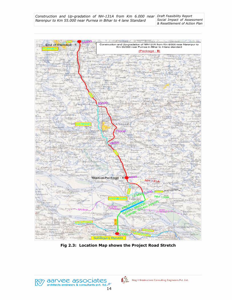
The proposed Package-II road passes through 33 villages of Purnia and Katihar
districts of Bihar state and they are Kutubpur, Pagalbari, Mohanpur, Jagbati,
Kumaripur, Bhearmara, Basantpur, Katihar, Marangi, Raghunichak, Sirnia,
Chitauria, Daharia, Sahisia, Baigna, Tiarpara, Dalan, Mehdai, Kadepura,
Rampur, Hathia Ramana, Baisi Ramana, Sadpur Rajwara, Routara, Dewanganj,
Singhia, Dimia Chattarjan, Raziganj, Raipur Ranipatra, Chandi, Bilauri, and
Abdullahnagar.
Table 2.1: Description of Package-II Project Road
Status of Existing RoadStatus of
Proposed Road
Name of Road Section
NH/SH Existing
Chainage (Old)
Existing Chainage
(New)
Existing Length (New) (Km.)
Design Chainage
Design Length (km)
Katihar More-Purnia -Katihar
SH-62/ (NH-131 A)
0.000 to 25.000
82.000-57.000 256.000-55.000
49.000Katihar-Manihari
SH-62/ (NH-131 A)
25.000 to 55.000 57.000-34.550 22.450
Total 47.450 49.000
2.2 EXISTING CHARACTERISTICS OF THE PROJEC ROAD
JV 11

Construction and Up-gradation of NH-131A from Km 6.000 near Narenpur to Km 55.000 near Purnea in Bihar to 4 lane Standard
Draft Feasibility Report Social Impact of Assessment & Resettlement of Action Plan
The carriageway width of the existing project road varies from 5.5m to 7.0m and
is having two/intermediate lane carriageway configuration. The carriageway
width from Km 82.000 to Km 57.000 i.e. Katihar More to Katihar is 2-lane
configuration with 7.0m wide road and the carriageway from Km 57.000 to Km
34.550 is intermediate lane configuration with 5.5m wide road.
Fig 2. 1: Two lane single carriageway without paved shoulder
Figure -2.2: Start Point and End Point of the Project
JV 12

Construction and Up-gradation of NH-131A from Km 6.000 near Narenpur to Km 55.000 near Purnea in Bihar to 4 lane Standard
Draft Feasibility Report Social Impact of Assessment & Resettlement of Action Plan
JV 13
Construction and Up-gradation of NH-131A from Km 6.000 near Narenpur to Km 55.000 near Purnea in Bihar to 4 lane Standard
Draft Feasibility Report Social Impact of Assessment & Resettlement of Action Plan
Fig 2.3: Location Map shows the Project Road Stretch
JV 14

Construction and Up-gradation of NH-131A from Km 6.000 near Narenpur to Km 55.000 near Purnea in Bihar to 4 lane Standard
Draft Feasibility Report Social Impact of Assessment & Resettlement of Action Plan
2.3 EXISTING RIGHT OF WAY AND ENCROACHMENT
As per the data obtained from Revenue Department, the average existing Right
of Way (ROW) all along the project corridor is around 10- 15 m. But when it
comes to the revenue maps obtained from the local Anchal or Village Panchayats
a variation is seen within the Right of Way. However, the Land Acquisition Plans
are prepared to have uniform ROW (45 m for improvement of the existing road
and 60m for bypass) in accordance with the NHAI guidelines.
About 5 habitations fall in both side of the project corridor will have impact by
widening of the road. Most of the road sided land in built-up location is occupied
by both encroachers and squatters. It is general tendency that road side
government land is usually occupied for commercial and residential purposes. It
may be driven by reason of landlessness, poverty or may be the sheer attraction
of business opportunity. Also, the practice of using government land for socio-
cultural and religious purpose is quite evident.
2.4 SCOPE OF SERVICES
As far as possible, the construction of new alignment shall be carried out within
the proposed right of way. The entire tract of alignment necessitates land
acquisition. However, in urban locations of Katihar town where widening of
existing road to four lane with configuration is not possible hence bypass
proposal is considered.
While finalizing the road alignment efforts have been made by adopting
appropriate engineering designs, to minimize resettlement impacts. To minimize
displacement and to reduce disruption of livelihoods one bypass has been
proposed. Public consultations and field visits would help in getting better
planning and design inputs towards minimizing negative social impacts. The total
design length of the corridor is 49 km.
JV 15

Construction and Up-gradation of NH-131A from Km 6.000 near Narenpur to Km 55.000 near Purnea in Bihar to 4 lane Standard
Draft Feasibility Report Social Impact of Assessment & Resettlement of Action Plan
Table 2.2: Salient Features of Package-II Project Road
Sl. No.
Particulars Unit
1 Total Length of proposed Road: Design Length (in km.) 49
2 Total number of Revenue Villages (Number) 33
3 Total Volume of Private Land needs to be acquired for the proposed Project (in Decimal)
49130
4 Agricultural Land to be acquired for the proposed Project (in Decimal) 22938
5 Commercial Land required for Project (in Decimal) 11598
6 Residential Land to be acquired (in Decimal) 14592
2.5 IMPACT ON REVENUE VILLAGES
Katihar town is the major urban location along the project road. The list of
villages/towns along the project stretch is given below in Table 2.3
Table 2.3: Villages in Package-II Road
Sl. No. NameChainage
From To
1 Kutubpur 7.000 8.000
2 Pagalbari 8.000 9.180
3 Manoharpur 9.180 10.180
4 Jagbati 10.180 10.760
5 Kumaripur 10.760 13.500
6 Bhermara 13.500 14.000
7 Basantpur 13.940 15.100
8 Katihar 15.000 16.000
9 Marangi 16.000 17.650
10 Raghunichak 17.650 17.870
11 Sirnia * 17.870 19.000
12 Chitauria* 19.000 19.500
13 Daharia* 20.700 23.350
14 Sahisia* 23.350 24.260
JV 16
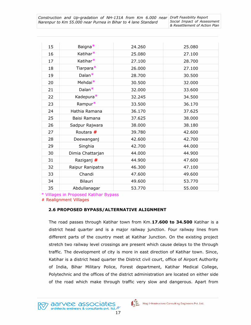
Construction and Up-gradation of NH-131A from Km 6.000 near Narenpur to Km 55.000 near Purnea in Bihar to 4 lane Standard
Draft Feasibility Report Social Impact of Assessment & Resettlement of Action Plan
15 Baigna* 24.260 25.080
16 Katihar* 25.080 27.100
17 Katihar* 27.100 28.700
18 Tiarpara* 26.000 27.100
19 Dalan* 28.700 30.500
20 Mehdai* 30.500 32.000
21 Dalan* 32.000 33.600
22 Kadepura* 32.245 34.500
23 Rampur* 33.500 36.170
24 Hathia Ramana 36.170 37.625
25 Baisi Ramana 37.625 38.000
26 Sadpur Rajwara 38.000 38.180
27 Routara # 39.780 42.600
28 Deewanganj 42.600 42.700
29 Singhia 42.700 44.000
30 Dimia Chattarjan 44.000 44.900
31 Raziganj # 44.900 47.600
32 Raipur Ranipatra 46.300 47.100
33 Chandi 47.600 49.600
34 Bilauri 49.600 53.770
35 Abdullanagar 53.770 55.000
* Villages in Proposed Katihar Bypass # Realignment Villages
2.6 PROPOSED BYPASS/ALTERNATIVE ALIGNMENT
The road passes through Katihar town from Km.17.600 to 34.500 Katihar is a
district head quarter and is a major railway junction. Four railway lines from
different parts of the country meet at Katihar Junction. On the existing project
stretch two railway level crossings are present which cause delays to the through
traffic. The development of city is more in east direction of Katihar town. Since,
Katihar is a district head quarter the District civil court, office of Airport Authority
of India, Bihar Military Police, Forest department, Katihar Medical College,
Polytechnic and the offices of the district administration are located on either side
of the road which make through traffic very slow and dangerous. Apart from
JV 17

Construction and Up-gradation of NH-131A from Km 6.000 near Narenpur to Km 55.000 near Purnea in Bihar to 4 lane Standard
Draft Feasibility Report Social Impact of Assessment & Resettlement of Action Plan
these, the presence of many commercial establishments like shops, kiosks and
residential buildings etc., are also prime reason for the congestion.
In this regard, a bypass is proposed for Katihar town and it takes off at Km.
47.300 and traverses on east side of the existing alignment and joins at Km.
61.555. The alignment traverses through agricultural lands and has good
geometrics. The design length of bypass is about 14.860 km.
Table-2.4: Proposed Katihar Bypass
Sl.No.
Design Chainage Proposed Length in Km.
Lane Configuration From To
1 18.770 33.630 14.860 4 lane divided Carriageway
2.7 LAND USE PATTERN
The project corridor passes through both plain terrain. A large chunk of land
constitutes built-up location followed by agricultural land.
Table 2.5 : Land Use Pattern
Type of Land Use Percentage of Land Use
Built up 54
Agricultural 46
Total 100
2.8 SOURCES OF IRRIGATION AND CROPPING PATTERN
The major source of irrigation is river and well in the study area. Besides this,
very limited area is irrigated through ponds and tube well. The important crop
grown in the present stretch is Jute and Paddy. During Kharif, the groundnut crop
is produced in irrigated areas. Maize also requires irrigation. Generally other
crops are sown at the commencement of the rainy season. Bajra, Groundnut,
Maize and Cotton are sown by broadcasting the seeds. Fertilizer is applied before
sowing of groundnut and cotton.
JV 18
Construction and Up-gradation of NH-131A from Km 6.000 near Narenpur to Km 55.000 near Purnea in Bihar to 4 lane Standard
Draft Feasibility Report Social Impact of Assessment & Resettlement of Action Plan
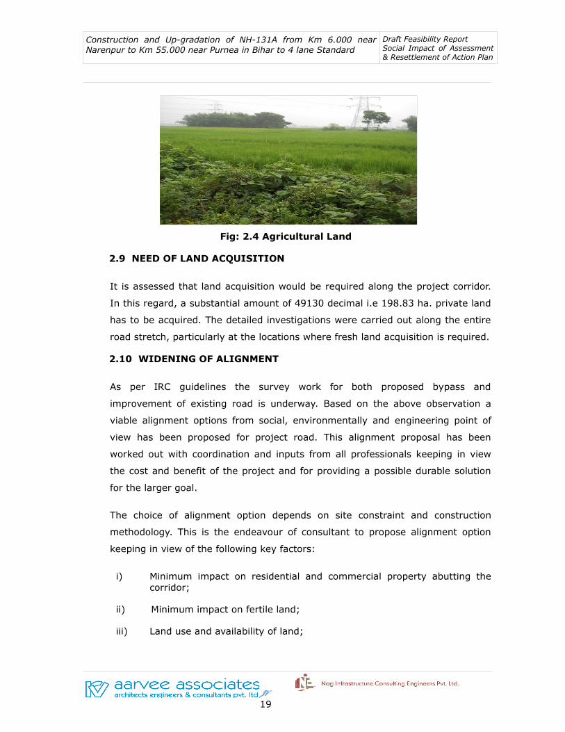
Fig: 2.4 Agricultural Land
2.9 NEED OF LAND ACQUISITION
It is assessed that land acquisition would be required along the project corridor.
In this regard, a substantial amount of 49130 decimal i.e 198.83 ha. private land
has to be acquired. The detailed investigations were carried out along the entire
road stretch, particularly at the locations where fresh land acquisition is required.
2.10 WIDENING OF ALIGNMENT
As per IRC guidelines the survey work for both proposed bypass and
improvement of existing road is underway. Based on the above observation a
viable alignment options from social, environmentally and engineering point of
view has been proposed for project road. This alignment proposal has been
worked out with coordination and inputs from all professionals keeping in view
the cost and benefit of the project and for providing a possible durable solution
for the larger goal.
The choice of alignment option depends on site constraint and construction
methodology. This is the endeavour of consultant to propose alignment option
keeping in view of the following key factors:
i) Minimum impact on residential and commercial property abutting the corridor;
ii) Minimum impact on fertile land;
iii) Land use and availability of land;
JV 19

Construction and Up-gradation of NH-131A from Km 6.000 near Narenpur to Km 55.000 near Purnea in Bihar to 4 lane Standard
Draft Feasibility Report Social Impact of Assessment & Resettlement of Action Plan
iv) Minimum impact on the environment;
v) Minimizing interference with religious structures such as Temples, Mosques, Churches etc;
vi) Minimizing interference with historical monuments and
vii) Least disturbance to traffic during construction
2.11 ROAD JUNCTIONS
There are 2 major junctions and 26 minor junctions along the project stretch and
the details are given in Table-2.6. Apart from these there are local gravel and
earthen roads leading to cluster of houses in villages and semi-urban stretches.
Table 2.6: Road Junction in Package-II
Major Junctions
S.No Chainage (Km)
Name of the Junction
Type LHS RHS
1 2.1 Belouri Chowk + Sonauli Bypass of NH 31
2 27.3Mahavir Mandir
ChowkY - Kora
Minor Junctions
1 6.9 Ranipatra Chowk +Ranipatra Rly
StationRanipatra
2 8.5 - + Motinagar Nalmatia
3 10.4 Shreenagar Chowk T - Shreenagar
4 11.8 Deewanganj Chowk + Deewanganj Rly Station
Shreenagar
5 15.8 Paltania Chowk T Rajbav Gram -
6 17.9 Govindpur Chowk TGovindpur Rly
Station-
7 19.4Hajikaleemuddin
ChowkT - Hajikaleemuddin
8 20.2 Hasalgan Chowk T Hasalgan -
9 22 Dalan Chowk T Dalan Rly Station
-
10 23.7 Sirsa Chowk T - Sirsa
11 24 - TSH-98 (To
Barsoi)-
12 24.5 - T - Katihar Medical College
13 27.6 Kushi Colony T - Kushi Colony
14 27.7 Kargil Chowk T - Manihari
JV 20
Construction and Up-gradation of NH-131A from Km 6.000 near Narenpur to Km 55.000 near Purnea in Bihar to 4 lane Standard
Draft Feasibility Report Social Impact of Assessment & Resettlement of Action Plan
15 28.4 Badmasiyah Chowk T Badmasiyah -
16 32.8 - Y - Mansahi Village
17 33.6 - TTeenghachiya
village-
18 35 Batnaha Chowk T Batnaha village
-
19 36.6 Hapla Chowk T Hapla village -
20 37.8 Mansahi Chowk T - Mansahi village
21 39.6 Kajre Chowk - - -
22 42.9 Kumaripudi Chowk T -Kumaripudi Rly
Station
23 43.7 - T Mahiyapur road
-
24 45.8 Mahiyapur Chowk T -Mahiyapur Rly
Station
25 50.8 - Y Amdavad -
26 54.4 Ambedkar Chowk + Amdavad Manihari Ghat
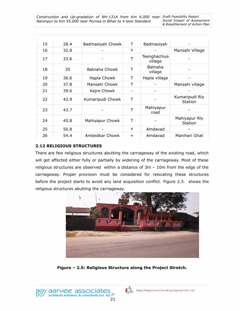
2.12 RELIGIOUS STRUCTURES
There are few religious structures abutting the carriageway of the existing road, which
will get affected either fully or partially by widening of the carriageway. Most of these
religious structures are observed within a distance of 3m – 10m from the edge of the
carriageway. Proper provision must be considered for relocating these structures
before the project starts to avoid any land acquisition conflict. Figure 2.5. shows the
religious structures abutting the carriageway.
Figure – 2.5: Religious Structure along the Project Stretch.
JV 21

Construction and Up-gradation of NH-131A from Km 6.000 near Narenpur to Km 55.000 near Purnea in Bihar to 4 lane Standard
Draft Feasibility Report Social Impact of Assessment & Resettlement of Action Plan
CHAPTER 3: SOCIO-ECONOMIC ANALYSIS OF PROJECT AREA
3.1 OVERALL APPROACH
The location through which the project road passes is considered to be the
primary project influence area. The Package-II road section would facilitate most
important traffic movement for the various parts of Bihar state as well as North-
East India. Therefore, the influence area of the project corridor, for the purpose
of socio economic study is considered with prime importance. The primary
purpose of Socio-economic analysis is to provide an overview of the State’s
socioeconomic setup and the relative status of the Project influence area within
the state. Data to be considered including demographic aspects, macro economic
indicators and sectoral production of agriculture and allied activities,
manufacturing, mining and service sectors including infrastructure. The profile
provides the present scenario, the past performance and the prospective growth
of the economy, population and urbanization. The profile depicts the spatial
distribution of economic activities and provides basic inputs for estimating future
growth in Transport demand, on the basis of prospective economic growth rates
and transport demand elasticity. Secondary data available with various
departments of state government have been collected and analyzed for
preparation of socio-economic profile.
3.2 GENERAL FEATURES OF PROJECT STATE
The project road passes through Bihar state which is eastern state of Indian
Peninsula. The 49 km. long project road traverse through two districts namely
Purnia and Katihar respectively. Bihar is 12th largest state in terms of
geographical size and 3rd largest state by population in the country. It is bounded
by Uttar Pradesh to its west, Nepal to the north, West Bengal to the east and by
Jharkhand to the south. The table 3.1 below presents key demographic indicators
and their comparison with pan-India numbers.
JV 22

Construction and Up-gradation of NH-131A from Km 6.000 near Narenpur to Km 55.000 near Purnea in Bihar to 4 lane Standard
Draft Feasibility Report Social Impact of Assessment & Resettlement of Action Plan
Table 3.1: Comparison of Demographic Indicators of Bihar State with Nation-2011
Sl. No.
Indicators Unit Bihar India
1 Geographical Area Lakh Sq. Km. 0.94 32.87
2 Population Crore 10.3 121.02
3 Decadal Growth Rate Percentage 25.1 17.64
4 Density of Population Population/Sq. Km. 1102 382
5 Urban to total Population
Percentage 31.89 31.16
6 Sex Ratio Females/1000 Males 916 940
7 Literacy Rate Percentage 63.80 74.04
8 Birth Rate Per 1000- Mid Year Population
27.7 22.50
9 Death Rate Per 1000-Mid Year Population
6.7 7.3
Source: Census India-2011
3.3 ECONOMIC OVERVIEWS OF BIHAR STATE
The present economic survey is an attempt to present in detail the current status
of the state’s economy, as well as its various sectors. The sectoral analysis will
highlight the efforts made by the state government for the different sectors and
their respective achievements. It will simultaneously point out the hindrances
that the economy is facing to maintain its growth momentum. Apart from this
Introductory chapter on the overview of the state’s economy, the survey has six
more chapters – Agriculture and Allied Sectors, Enterprises Sector, Infrastructure
and Communications, Social Sector, Banking and Allied Sector and, finally, State
Finances.
3.3.1 State Domestic Product
The GSDP of Bihar at 2004-05 prices in 2012-13 is Rs. 1.65 lakh crore, yielding a
per capita income of Rs. 16,537. The estimated GSDP at current prices in 2012-
13 is Rs. 3.09 lakh crore, implying a per capita income of Rs. 30,930. The growth
rate of Bihar's economy has not been uniform over the period 1999-2000 to
JV 23

Construction and Up-gradation of NH-131A from Km 6.000 near Narenpur to Km 55.000 near Purnea in Bihar to 4 lane Standard
Draft Feasibility Report Social Impact of Assessment & Resettlement of Action Plan
2012-13. During the 1999-2000 to 2005-06, the state income at constant prices
grew at an annual rate of 5.7 percent. After that, the economy witnessed a
turnaround and grew at an annual rate of 12.0 percent, which was not only much
higher than what was achieved in previous period, but one of the highest among
all the Indian states.
3.3.2 Economic Sectors
With development of economic, it is observed that structures of economy has
undergone many changes in their relative size over the years. The growth rates
of different sectors vary because of shifting demand patterns, a consequence of
rising income. Labour force also tends to shift from primary sector to more
prosperous industry and services. In Table 1.5 the structure of Bihar's economy
has been presented for the period 2003-04 to 2012-13.
In Bihar, Manufacturing and Services Industry are the keystone of the economy
in terms of creation of employment, provision of wage goods and market for the
goods and services produced in the secondary and tertiary sectors.
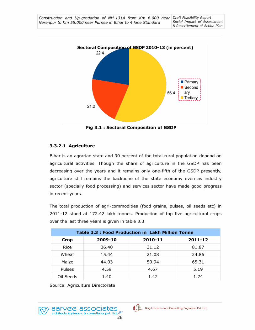
According to the Economic Review, 2013-14 report, the Primary sector which
includes agriculture, animal husbandry, forestry and fishing sector contributes
about 22.4% whereas Secondary sector or industries sector includes mining &
quarrying, manufacturing, utilities (electricity, gas and water supply) and
construction constitutes 21.2% of the state economy. The tertiary sector includes
transport, communication, trade, hotels and restaurants, banking and insurance,
real-estate, ownership of dwelling, business services, public administration and
other services contribute 56.4% to the state's economy as shown in Table – 3.2
and Figure – 3.1.
Table –3.2: Sectoral Contribution of GSDP at Constant(2004-05) Prices
Sector Unit 2003-06 (TA) 2007-10 (TA) 2010-13 (TA)
Primary % 30.9 25.9 22.4
Secondary % 13.8 17.9 21.2
Tertiary % 55.3 56.2 56.4 Source: Directorate of Economic and Statistics, GoB Note: TA= Triennium Average
JV 24

Construction and Up-gradation of NH-131A from Km 6.000 near Narenpur to Km 55.000 near Purnea in Bihar to 4 lane Standard
Draft Feasibility Report Social Impact of Assessment & Resettlement of Action Plan
In the beginning of the last decade, the average share of 3 major sectors in total
GSDP stood at 30.9 percent (primary), 13.8 percent (secondary) and 55.3
percent (tertiary). Thereafter, the share of the primary sector has been showing
a decline over the years, and it came down to 25.9 percent for the triennium
ending 2009-10 and then to 22.4 percent for the triennium ending 2012-13. This
shows that the importance of the primary sector has declined steadily over the
years. Since secondary and tertiary sectors recorded tremendous growth rate in
the last decade, their shares of outputs are much higher than those in the
triennium ending 2005-06. The relative share for the triennium ending 2012-13
now stands thus: primary (22.4 percent), secondary (21.2 percent) and tertiary
(56.4 percent).
Within the three major sectors, some sub-sectors have also recorded substantial
change in their share. For example, in the primary sector, Agriculture and Animal
husbandry recorded substantial decrease in its share. Within secondary sector,
the sub-sector which showed substantial change is construction, whose share in
GSDP increased from 6.7 percent in the triennium 2003-06 to 14.2 percent in the
triennium 2010-13. Within the tertiary sector, the sub sector which recorded
higher growth and caused its share to rise was trade, hotel and restaurants.
Organised sub-sectors like Public Administration and other services lost in terms
of their shares in GSDP.
JV 25
Construction and Up-gradation of NH-131A from Km 6.000 near Narenpur to Km 55.000 near Purnea in Bihar to 4 lane Standard
Draft Feasibility Report Social Impact of Assessment & Resettlement of Action Plan
Fig 3.1 : Sectoral Composition of GSDP
3.3.2.1 Agriculture
Bihar is an agrarian state and 90 percent of the total rural population depend on
agricultural activities. Though the share of agriculture in the GSDP has been
decreasing over the years and it remains only one-fifth of the GSDP presently,
agriculture still remains the backbone of the state economy even as industry
sector (specially food processing) and services sector have made good progress
in recent years.
The total production of agri-commodities (food grains, pulses, oil seeds etc) in
2011-12 stood at 172.42 lakh tonnes. Production of top five agricultural crops
over the last three years is given in table 3.3
Table 3.3 : Food Production in Lakh Million Tonne
Crop 2009-10 2010-11 2011-12
Rice 36.40 31.12 81.87
Wheat 15.44 21.08 24.86
Maize 44.03 50.94 65.31
Pulses 4.59 4.67 5.19
Oil Seeds 1.40 1.42 1.74
Source: Agriculture Directorate
JV 26
22.4
21.2
56.4
Sectoral Composition of GSDP 2010-13 (in percent)
Primary SecondaryTertiary
Construction and Up-gradation of NH-131A from Km 6.000 near Narenpur to Km 55.000 near Purnea in Bihar to 4 lane Standard
Draft Feasibility Report Social Impact of Assessment & Resettlement of Action Plan
3.3.3 Per Capita Income
The per capita Income is derived by dividing the Net State Domestic Product by
the total population of the State. As per advance estimates, the per capita
income for the year 201-12 at current prices is estimated at 15,417 as compared
to 13,388 of the previous year 2010-11 showing an increase of 15.16 % over the
previous year. According to 2011-12 the per capita income at constant prices
was recorded as Rs. 25,653 compared to 20769 for the year 2010-11 showing an
increase of 23.52% over the previous year.
3.4 TRANSPORT
3.4.1 Road Network in Bihar State
The roads are important basic infrastructure, playing a crucial role in
development of other essential infrastructure in a region. For this, not only the
trunk roads are needed, but equally important is the wide network of arteries for
better connectivity to take the developmental activities to the remote areas. The
state government has taken up the construction of roads and bridges on a large
scale in keeping with its resolution of connecting the state capital with the
remotest area so as to cover the distance within a maximum time of 6 hours.
Besides, with a view to ensuring better maintenance of roads in the state, a Bihar
Road Resource Protection Policy has been prepared in 2013-14. However, despite
all these endeavours, the state continues to remain much behind the all-India
average in terms of road length both per lakh of population and per 100 sq. kms.
Against a road length of 347.05 kms per lakh of population at all-India level in
2011-12, Bihar presented a very dismal picture with only 108.60 kms. Even the
road length per 100 sq. kms. was much less in Bihar (119.72 kms.), compared to
all India (127.76 kms.). In 2012-13, Bihar with 174.88 kms. of road length per
lakh population lagged much behind the all-India (387.53 kms) average as
before; but, in terms of road length per 100sq.km., it by-passed all-India
(142.67 kms) with a record achievement of 192.78 kms. As is discerned from the
Table 3.4, in 2012-13, Bihar recorded a big jump by over 73 kms. over the
previous year, as against only 15 kms. at the all-India level.
JV 27

Construction and Up-gradation of NH-131A from Km 6.000 near Narenpur to Km 55.000 near Purnea in Bihar to 4 lane Standard
Draft Feasibility Report Social Impact of Assessment & Resettlement of Action Plan
During the period October, 2012 and September, 2013, there has been an
increase of 466.33 kms. in the length of National Highways (NH) in the state,
registering an increase of 12.5 percent. However, the State Highways (SH)
registered a decline in road length of about 374 kms. during the period,
indicating that this much length of SH has been upgraded as NH during the year.
The Major District Roads (MDR), registered an increase of 4.64 percent over the
last year, and the length of rural roads increased by around 32.5 percent.
The highways and roads in the state are constructed under different categories,
based on width. As may be observed from Table 3.4, while National Highways
(NH) and State Highways (SH)reportedly has the higher proportion in double lane
category of 7.00 meter width, the Major District Roads mostly consist of single
lane category (3.75 m. width). The district wise road network in Bihar is given in
Table 3.4
The state's road network consists of National Highways, State Highways, Major
District Roads, Other District Roads being maintained by Public Works
Department of the state. Bihar has the largest network of National Highways in
Northern India. The state roads comprise of 32 National Highways and 85 State
Highways.
• In 2012-13, Bihar with 174.88 kms. of road length per lakh population
lagged much behind the all-India (387.53 kms) average as before; but,
in terms of road length per 100 sq.km., it by-passed all-India (142.67
kms) with a record achievement of 192.78 kms. and recorded a big jump
by over 73 kms. over the previous year as against only 15 kms. at all-
India level.
• During October, 2012 and September, 2013, there has been an increase
of 466.33 kms. in the length of National Highway (NH) in the state,
registering an increase of 12.5 percent. However, the State Highways
registered a decline in road length of about 374 kms. during the period,
indicating that this much length of SH has been upgraded as NH during
the year. The Major District Roads (MDR), registered an increase of 4.64
percent over the last year, and the length of rural roads increased by
JV 28

Construction and Up-gradation of NH-131A from Km 6.000 near Narenpur to Km 55.000 near Purnea in Bihar to 4 lane Standard
Draft Feasibility Report Social Impact of Assessment & Resettlement of Action Plan
around 32.5 percent.
• There were 28 National Highways in the state upto September 2012;
with the addition of 4 more highways during the year, their number has
now become 32, measuring a total length of 4200.71 kms. The length of
National Highways in Bihar is quite inadequate in view of its strategic
location, bordering Nepal. Efforts are underway to increase the existing
length.
• The total length of State Highways (SH) in Bihar is 4483.19 kms., as on
September, 2013. The State Highways have around 62 percent of double
lane roads, 22 percent of single lane and 15 percent of intermediate lane
roads. The four lane roads with width of 14 meters constitute a very
negligible proportion (0.98 percent) of the total road length under State
Highways.
• The Major District Roads in the state are 9449.36 kms. in length, with
varying widths. In view of the inadequacy of width (3.05 – 3.50 m.) of a
majority of MDRs in the state and their incapacity to cope with the
increasing traffic intensity, the state government is making endeavours to
upgrade these roads to a minimum intermediate lane standard with a
width of 5.50 meters. The upgradation work will be taken up, subject to
the availability of funds; in case such upgradation is not possible, their
surface is planned to be renewed.
• The total length of rural roads works out to around 1.62 lakh kms. in
Bihar, of which a substantial proportion is unpaved. The Rural Works
Department constructs rural roads and bridges under various schemes
and has completed about 39,809 kms. of roads at an expenditure of Rs.
18,743 crore. On an average, this implies laying of 41.47 kms. new roads
per day upto September 2013.
• The construction of road over bridges at 22 railway crossings in the state
was taken up on cost sharing basis. The work on 14 road over bridges
was undertaken by IRCON International. Till date, 10 of these road over
JV 29

Construction and Up-gradation of NH-131A from Km 6.000 near Narenpur to Km 55.000 near Purnea in Bihar to 4 lane Standard
Draft Feasibility Report Social Impact of Assessment & Resettlement of Action Plan
bridges have already been completed and the work on the remaining four
is in progress. Besides, 8 road over bridges on Major District Roads have
been constructed by IRCON International and the approach roads to 7
out of these 8 have been constructed by the Bihar Rajya Pul Nirman
Nigam Ltd.
Table 3.4: Status of Highways in Bihar (upto September 2013)
Category Road Length (Km.)
September 2012
September 2013
Increase/ Decrease over
the year
National Highways(NH) 3734.38 4200.71 466.33
State Highways (SH) 4857.00 4483.19 -373.81
Major District Roads (MDR) 9030.59 9449.36 418.77
Rural Roads(RR) 122598.00 162407.15 39809.15
Total 140219.97 180540.41 40320.44
Source: Departments of Road Construction & Rural Works, GOB -2013
3.4.2 Traffic Growth Rate
The number of vehicles in the transport sector has grown rapidly over the last
several years. The number of registered vehicles is increasing every year and
recorded more than three fold increase from 1.62 lakh in 2007-08 to around 5
lakh in 2012-13. During the first six months of 2012-13 (April-September), 2.85
lakh new vehicles have been registered. All categories of vehicles recorded a
phenomenal increase during the recent years. While the trucks and auto-
rickshaws displayed almost a five fold increase, the vehicles like cars, taxis,
tractors and the two-wheelers recorded around three fold increase during the
period.
3.5 SOCIO-ECONOMIC PROFILE OF PROJECT INFLUENCED DISTRICTS
3.5.1 DEMOGRAPHIC PROFILE OF PROJECT DISTRCTS
The project influenced district of Purnia and Katihar is spread over 6286 sq. km.
JV 30

Construction and Up-gradation of NH-131A from Km 6.000 near Narenpur to Km 55.000 near Purnea in Bihar to 4 lane Standard
Draft Feasibility Report Social Impact of Assessment & Resettlement of Action Plan
with a population of 6335648 i.e. (6.09 %) of state population, according to
2011 census. Purnia is the most populous project district with 3264619
population which is 3.14% of state population whereas the population of Katihar
district stands at 3071029. There is a rapid increase in the density of project
districts population during the decade of 2001-2011. Purnia district was recorded
highest density with 1011 persons per sq. km. & Katihar district with 1005
persons per sq.km.
Human development means increased capabilities of people that enable them to
access larger opportunities in life. In the context of HDI in PIA districts, Katihar
tops the position. In Gender Empowerment Measure (GEM) Katihar district scales
the height of success between the project districts. GEM measures whether
women and men are able to actively participate in economic and political life and
in decision making. While GDI focuses on expansion of capabilities, GEM is
concerned with the use of those capabilities to take advantage of the
opportunities in life. While political freedoms, participating in community and
physical security are important parameters for measuring the value and position
of women in the society. By and large, both districts exhibit same characteristics
on the above mentioned points.
Sex ratio is an important dimension in demographic study of a region. It indicates
the number of female per 1000 of males. Ironically, The sex ratio of Katihar
district goes down with 919 whereas Purnia district is recorded with. The sex
ratio of both Purnia and Katihar district is considered among the best 5 districts
in Bihar state.
Table –3.5: Demographic Profile of Project Districts
District
Population % in State Population
% of Urban pop. to
Total Dist. population
Population Density
(Person/sq.KmTotal Rural Urban
Katihar 3071029 2797093 273936 2.95 8.92 1005
Purnia 3264619 2921614 343005 3.14 10.51 1011
Source: Census India & Directorate of Economics and Statistics, Govt. of Bihar - 2011
JV 31

Construction and Up-gradation of NH-131A from Km 6.000 near Narenpur to Km 55.000 near Purnea in Bihar to 4 lane Standard
Draft Feasibility Report Social Impact of Assessment & Resettlement of Action Plan
3.5.2 LITERACY PROFILE IN PIA DISTRICTS
The project districts have registered impressive growth in literacy in comparison
to some districts of Bihar state. With regard to literacy of male & female category
in project districts, Katihar district tops with 52.24% whereas Purnia district
remains with 51.08 %. The female literacy rate in both district is significantly
lower than the national average. The demographic and Socio-economic
characteristics of the Project district is presented in Table 3.6.
Table 3.6: Socio-Economic Details of Project Districts- 2011 Census
Sl. No
Item UnitName of the District
Katihar Purnia
1 Population Number 3071029 3264619
2 Male Number 1600430 1699370
3 Female Number 1470599 1565249
4 District Area Sq.Km. 3057 3229
5 No. of Villages Number 1548 1282
6 No. of Anchal cum Blocks Number 16 14
7 SC Population Number 263100 292461
8 SC- Male Number 136429 150858
9 SC- Female Number 126671 141603
10 ST Population Number 179971 103493
11 ST- Male Number 92190 53061
12 ST- Female Number 87871 50432
13 Sex ratio (Female per 1000 males)
Number 919 921
14 Population Growth Rate % 28.35 28.33
15 Total Literacy % 52.24 51.08
16 Male Literacy % 59.36 59.06
17 Female Literacy % 44.39 42.34
18 Total Workers Number 3056897 3326306
19 Main Workers Number 664259 782364
20 Cultivator Number 160117 191615
21 Agricultural Labour Number 379464 473664
JV 32

Construction and Up-gradation of NH-131A from Km 6.000 near Narenpur to Km 55.000 near Purnea in Bihar to 4 lane Standard
Draft Feasibility Report Social Impact of Assessment & Resettlement of Action Plan
22 Household Industry Worker Number 15062 12074
23 Other Workers Number 109616 105011
24 Marginal Workers Number 234067 178336
25 Non Workers Number 1494312 1583242
Source: District Statistical Handbook of BAES & Economic Review,2012-13,Govt. of Bihar
3.6 LAND USE PATTERN
As per the land utilization statistics of 2010-11, out of the total geographical area
605232 ha. the combined cropped area of the project districts was 515048
hectares. The net sown area constitutes of 377339 hectares land. About 1898 ha,
of land is covered under forest. The land use pattern is shown in Table 3.7.
Table – 3.7: Land Use Pattern in Project Districts upto 30/06/2010
Sl. No.
Land Utilization Particulars Unit Katihar Purnia
1 Total Geographical Area Hectare 291349 313883
2 Total Reporting Area for Land Utilization
Hectare 291349 313883
3 Total Cropped Area Hectare 254671 260377
4 Net Area Sown Hectare 168737 208302
5 Forest Land Hectare 1785 113 Source: Directorate of Economics and Statistics, GoB – 2012-13
3.7 CROPPING PATTERN
Paddy, Wheat, Maize, Pulses, Sesamum, Jute, Potato, Groundnut, linseed, Rape
and mustard are widely shown in the project districts. The cropping pattern has
changed over the last two decades as a result of development of irrigation
potential, production technologies, market prices and industrial demands.
There is a moderate growth in area under gram and groundnut. However, there
was an increase in growth rate in area under paddy in kharif crops and jute in
project districts as shown in Table – 3.8, below.
Table – 3.8: The Production of Food grains (in Metric Tonnes) - 2009-10
JV 33
Construction and Up-gradation of NH-131A from Km 6.000 near Narenpur to Km 55.000 near Purnea in Bihar to 4 lane Standard
Draft Feasibility Report Social Impact of Assessment & Resettlement of Action Plan
District Rice Wheat Maize Jute Potato
Katihar 171 69 141 277 58
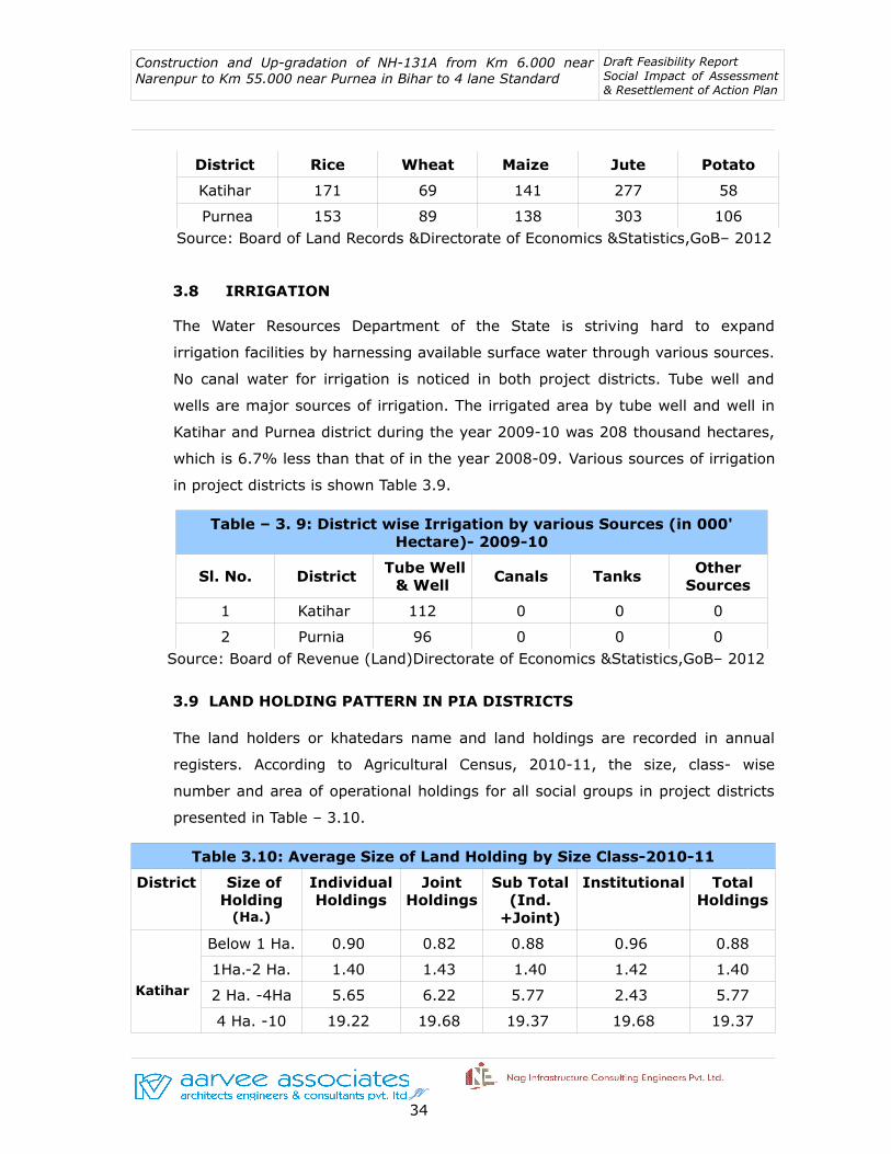
Purnea 153 89 138 303 106 Source: Board of Land Records &Directorate of Economics &Statistics,GoB– 2012
3.8 IRRIGATION
The Water Resources Department of the State is striving hard to expand
irrigation facilities by harnessing available surface water through various sources.
No canal water for irrigation is noticed in both project districts. Tube well and
wells are major sources of irrigation. The irrigated area by tube well and well in
Katihar and Purnea district during the year 2009-10 was 208 thousand hectares,
which is 6.7% less than that of in the year 2008-09. Various sources of irrigation
in project districts is shown Table 3.9.
Table – 3. 9: District wise Irrigation by various Sources (in 000' Hectare)- 2009-10
Sl. No. District Tube Well & Well
Canals Tanks Other Sources
1 Katihar 112 0 0 0
2 Purnia 96 0 0 0 Source: Board of Revenue (Land)Directorate of Economics &Statistics,GoB– 2012
3.9 LAND HOLDING PATTERN IN PIA DISTRICTS
The land holders or khatedars name and land holdings are recorded in annual
registers. According to Agricultural Census, 2010-11, the size, class- wise
number and area of operational holdings for all social groups in project districts
presented in Table – 3.10.
Table 3.10: Average Size of Land Holding by Size Class-2010-11
District Size of Holding
(Ha.)
Individual Holdings
Joint Holdings
Sub Total (Ind.
+Joint)
Institutional Total Holdings
Katihar
Below 1 Ha. 0.90 0.82 0.88 0.96 0.88
1Ha.-2 Ha. 1.40 1.43 1.40 1.42 1.40
2 Ha. -4Ha 5.65 6.22 5.77 2.43 5.77
4 Ha. -10 19.22 19.68 19.37 19.68 19.37
JV 34

Construction and Up-gradation of NH-131A from Km 6.000 near Narenpur to Km 55.000 near Purnea in Bihar to 4 lane Standard
Draft Feasibility Report Social Impact of Assessment & Resettlement of Action Plan
Ha
10 Ha & above
12.27 11.94 12.18 15.01 12.27
Purnia
Below 1 Ha. 0.92 0.88 0.92 0.66 0.92
1Ha.-2 Ha. 1.30 1.28 1.30 1.26 1.30
2 Ha. -4Ha 5.72 5.82 5.73 5.81 5.73
4 Ha. -10 Ha
18.86 10.07 18.86 10.15 18.86
10 Ha & above
0.00 0.00 0.00 0.00 0.00
Source: Agricultural Census, GoB-2011
3.10 TRAFFIC GROWTH RATE
Past trend in the growth rates of traffic intensity along the project corridor
provide a valuable clue to the likely future traffic growth rate. But in some cases,
the past traffic data is inconsistent and can not be taken as a basis for future
traffic growth rate. Alternatively, the motor vehicle registration data at the state
level over the recent past provide more consistent information on the trends in
their growth and thus presents a better tool for estimating future growth rates in
different categories of vehicles. The total number of motor vehicles registered
with the Transport Department of the state was 33301 during 2011- 12. The
details of various category of vehicles registered in 2011-12 and the road
networks in project districts are given in Tables – 3.11 and 3.12 respectively.
Table – 3.11: Motor Vehicles Registration Data in Project Districts
Sl. No
District Trucks Bus Cars Taxi Jeeps Three Wheelers
Two Wheelers
Tactor Tailors Others
Total Registered Motor Vehicles
1 Katihar 14 6 111 26 9 86 14650 511 169 8 15590
2 Purnia 451 44 788 680 714 1654 10585 2121 674 0 17711
Source: Commissioner of Transport, Transport Dept., Bihar
JV 35

Construction and Up-gradation of NH-131A from Km 6.000 near Narenpur to Km 55.000 near Purnea in Bihar to 4 lane Standard
Draft Feasibility Report Social Impact of Assessment & Resettlement of Action Plan
Table – 3.12 : Road Network in Project District
Sl. No. District NH SH MDR
1 Katihar 90 115.98 375.93
2 Purnia 103.00 161.48 286.25
Source: Public Works Department, Bihar
CHAPTER 4: SOCIAL IMPACT ASSESSMENT
4.1 MAGNITUDE OF IMPACTS
This chapter contains the intensity and magnitude of losses due to the
construction of package-II road. The impacts of the present project include loss
of land (agriculture, residential and commercial), structure (residential,
commercial, government and other assets) and religious properties.
The project impacts were identified through a series of exercises including social
screening during early project preparation stage and informal public consultation
as part of social impact assessment in the project area. A structured format was
used to collect detailed information of the affected structures from the proposed
centre line. The objective of the survey was to generate an inventory of social
impacts on the people affected by the project, the type of impact, type of
ownership, usage of structures and its typology etc. and the views of the likely to
JV 36

Construction and Up-gradation of NH-131A from Km 6.000 near Narenpur to Km 55.000 near Purnea in Bihar to 4 lane Standard
Draft Feasibility Report Social Impact of Assessment & Resettlement of Action Plan
be affected person about the project. The major findings and magnitude of
impacts are discussed in the following sections.
4.2. EXTENT OF LAND ACQUISITION
The proposed cross sections indicate that about 45/60 meter width is required to
accommodate various features of proposed road. For widening of the existing
road the social assessment of the impact was conducted within 22.5 m on either
side of proposed centre line. The proposed 60 meter width is earmarked for
development of bypass.
The 49 kilo meter length of the project corridor requires agricultural, commercial
and residential land constituting 49130 decimal. With regard to improvement and
widening of existing road a substantial amount of 19510 decimal of land is
required. Similarly, a major extent of 25614 decimal land is also required for
construction of Katihar bypass. The scope of land acquisition in the project road
sections includes a) for upgradation of existing road a minimum 45m RoW is
required as per MoRTH Guideline b) Bypass is proposed to avoid the impact on
the properties and livelihood that requires 60m RoW c) provisions on road side
amenities. Table 4.1 presents the detail account of land to be acquired for the
project road.
Table 4.1: Land Requirement for Proposed Alignment
Sl. No.
Project Component Total Required Land (Decimal)
1 For Improvement & Widening of Existing Road 19510
2 For Construction of Katihar Bypass 25614
3 For Proposed Realignment 4006
Total 49130
Source: Land Plan Schedule, Aarvee Associates, Hyderabad-2015
4.2.1 Project Impact Zone
With regard to village wise land acquisition, the highest volume of 4399 decimal
of land requires from Daharia village whereas 64 decimal of least amount of land
JV 37

Construction and Up-gradation of NH-131A from Km 6.000 near Narenpur to Km 55.000 near Purnea in Bihar to 4 lane Standard
Draft Feasibility Report Social Impact of Assessment & Resettlement of Action Plan
needs to be acquired in Raghunichak village. The village wise land details is given
in Table 4.2.
Table 4.2: Village wise Project Impact & Requirement of Land (in Decimal) for Package-II
Sl. No.
Village Commercial Residential Agriculture Total Required Land for Project
1 Kutubpur 450 450 0 900
2 Pagalbari 503 503 0 1006
3 Manoharpur 479 479 0 958
4 Jagbati 261 261 0 521
5 Kumaripur 770 770 1541 3082
6 Bhermara 152 152 0 303
7 Katihar 264 264 791 1318
8 Basantpur 289 289 385 964
9 Marangi 126 126 586 837
10 Raghunichak 16 16 32 64
11 Sirnia 715 715 1430 2860
12 Chitauria 0 248 991 1239
13 Daharia 440 1760 2200 4399
14 Sahisia 63 253 316 633
15 Baigna 570 0 1329 1899
16 Tiarpara 573 573 287 1433
17 Katihar 311 0 2801 3112
18 Dalan 1037 1382 1037 3456
19 Mehdai 696 928 696 2321
20 Kadepura 274 274 821 1369
21 Rampur 579 868 1447 2893
22 Hathia Ramana 228 342 570 1141
23 Baisi Ramana 158 237 395 789
24 Sadpur Rajwara 188 282 470 941
25 Routara 468 703 1171 2342
JV 38
Construction and Up-gradation of NH-131A from Km 6.000 near Narenpur to Km 55.000 near Purnea in Bihar to 4 lane Standard
Draft Feasibility Report Social Impact of Assessment & Resettlement of Action Plan
26 Deewanganj 44 65 109 218
27 Singhia 117 265 442 884
28 Dimia Chattarjan 150 225 374 749
29 Raziganj 333 499 832 1664
30 Raipur Ranipatra 105 158 263 527
31 Chandi 202 303 505 1010
32 Bilauri 447 670 1117 2234
33 Abdullahnagar 532 532 0 1064
Total 11598 14592 22938 49130
Source: Design and Land Plan, Aarvee Associates, Hyderabad,2015
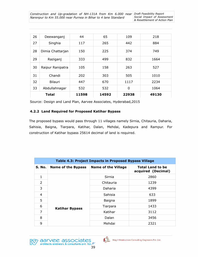
4.2.2 Land Required for Proposed Katihar Bypass
The proposed bypass would pass through 11 villages namely Sirnia, Chitauria, Daharia,
Sahisia, Baigna, Tiarpara, Katihar, Dalan, Mehdai, Kadepura and Rampur. For
construction of Katihar bypass 25614 decimal of land is required.
Table 4.3: Project Impacts in Proposed Bypass Village
S. No. Name of the Bypass Name of the Village Total Land to be acquired (Decimal)
1
Katihar Bypass
Sirnia 2860
2 Chitauria 1239
3 Daharia 4399
4 Sahisia 633
5 Baigna 1899
6 Tiarpara 1433
7 Katihar 3112
8 Dalan 3456
9 Mehdai 2321
JV 39
Construction and Up-gradation of NH-131A from Km 6.000 near Narenpur to Km 55.000 near Purnea in Bihar to 4 lane Standard
Draft Feasibility Report Social Impact of Assessment & Resettlement of Action Plan
10 Kadepura 1369
11 Rampur 2893
25614
Source: Land Records, Revenue Dept., Katihar Dist and 3(a) Notification
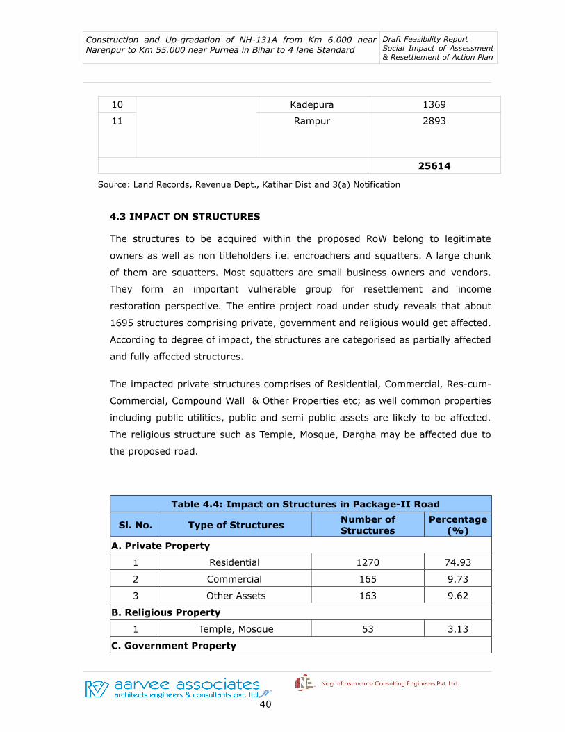
4.3 IMPACT ON STRUCTURES
The structures to be acquired within the proposed RoW belong to legitimate
owners as well as non titleholders i.e. encroachers and squatters. A large chunk
of them are squatters. Most squatters are small business owners and vendors.
They form an important vulnerable group for resettlement and income
restoration perspective. The entire project road under study reveals that about
1695 structures comprising private, government and religious would get affected.
According to degree of impact, the structures are categorised as partially affected
and fully affected structures.
The impacted private structures comprises of Residential, Commercial, Res-cum-
Commercial, Compound Wall & Other Properties etc; as well common properties
including public utilities, public and semi public assets are likely to be affected.
The religious structure such as Temple, Mosque, Dargha may be affected due to
the proposed road.
Table 4.4: Impact on Structures in Package-II Road
Sl. No. Type of StructuresNumber of Structures
Percentage (%)
A. Private Property
1 Residential 1270 74.93
2 Commercial 165 9.73
3 Other Assets 163 9.62
B. Religious Property
1 Temple, Mosque 53 3.13
C. Government Property
JV 40

Construction and Up-gradation of NH-131A from Km 6.000 near Narenpur to Km 55.000 near Purnea in Bihar to 4 lane Standard
Draft Feasibility Report Social Impact of Assessment & Resettlement of Action Plan
1 Govt. Offices 44 2.60
Total (A+B+C) 1695 100
4.3.1 Usage of Structures
Of total 1695 structures, 827 structures may get affected completely. Some
titleholders properties which fall beyond the existing RoW may also be acquired
for the development of the project road. A substantial 868 number of partially
affected structures are identified within the proposed RoW. Under the partially
affected category a significant number of structures constituting residences, huts
and compound walls or fences may be affected. In some places only front portion
of residential and commercial units may be affected. As regard to structures of
both category i.e., fully affected and partially affected structures, we found that
the residential structures of semi pucca category constitute a large chunk of 514
followed by Kutcha houses with 505. The list of affected structures is presented
in Table 4.5.
Table 4.5: Identification and Usage of Structures across the Project Road
Sl. No.
Name of the StructuresPartially Affected Fully Affected
No. Percentage (%)
No. Percentage (%)
A. PRIVATE STRUCTURES
I. Residential
1 Hut/Kutcha 137 15.78 368 44.50
2 Residential Semi Pucca 335 38.59 179 21.64
3 Residential Pucca 219 25.23 32 3.87
II. Commercial
4 Commercial Structure-Semi Pucca
62 7.14 86 10.40
5 Petrol Bunk 1 0.12 4 0.48
6 Educational Inst. Pucca 10 1.15 2 0.24
III. Other Assets
7 Small Room 4 0.4610
1.21
8 Wells 1 0.12 6 0.73
9 Toilet 3 0.35 29 3.51
JV 41

Construction and Up-gradation of NH-131A from Km 6.000 near Narenpur to Km 55.000 near Purnea in Bihar to 4 lane Standard
Draft Feasibility Report Social Impact of Assessment & Resettlement of Action Plan
10 Compound Wall 80 9.22 30 3.63
B. GOVERNMENT STRUCTURES
11 Govt. Office 11 1.27 19 2.30
12 Bus Stop 0 0.00 13 1.57
13 Hospital 0 0.000 1 0.12
C. RELIGIOUS STRUCTURES
1 Temple, Mosque 5 0.58 48 5.80
Total (A+B+C) 868 100.00 827 100.00
Source: Survey Data, Aarvee Associates, Hyderabad,2015
Approximately, 90.21 percent private structures which comes under fully affected
category might be affected followed by 3.99 percent government structures, 5.8
percent religious structures.
CHAPTER 5: LEGAL POLICY FRAME WORK & ENTITLEMENT MATRIX
5.1 INTRODUCTION
This chapter contains the resettlement plan for the potential social impact
anticipated due to the proposed project. In this regard, a compatible
Rehabilitation and Resettlement Policy has to be developed based on
JV 42
Construction and Up-gradation of NH-131A from Km 6.000 near Narenpur to Km 55.000 near Purnea in Bihar to 4 lane Standard
Draft Feasibility Report Social Impact of Assessment & Resettlement of Action Plan
Government of India and State Government Policy and accordingly a full
resettlement action plan will be prepared for the project in the subsequent
stages of project preparation.
All strategic interventions on human development, spread across all social
issues, need directives of policies and legal support to operationalise the
appropriate actions. These policies and legislations help to overcome the
constraints and support administrator, implementer, community and
individual in delivery of justice. This chapter includes the World Bank as well
as National policies and Acts applicable to the proposed Project are detailed
under:
5.2 OBJECTIVES OF RESETTLEMENT POLICY
This RAP is project specific resettlement plan and has been prepared in the
line of Government Policy. The RAP is based on the general findings of the
census and socio economic survey, field visits, and meetings with various
project affected persons in the project area. The primary objective of the
RAP is to identify impacts and to plan measures to mitigate various losses
due proposed project. The specific objectives are as follows:
• To minimize displacement and to promote least displacing
alternatives
• To ensure adequate rehabilitation package and expeditious
implementation of rehabilitation process with the active
participation
• To provide better living conditions and making concerted effort for
providing sustainable income to affected families
• Develop harmonious relationship between requiring body and
affected families
The RAP outlines the details of the project, description of the project
location, the magnitude of impacts based on the census, and spells out the
necessary implementation procedures for resettlement and rehabilitation of
JV 43
Construction and Up-gradation of NH-131A from Km 6.000 near Narenpur to Km 55.000 near Purnea in Bihar to 4 lane Standard
Draft Feasibility Report Social Impact of Assessment & Resettlement of Action Plan
the entire project affected families including the entitlement matrix as well
as the legal framework and policies.
5.3 POLICY FRAMEWORK
The policy framework and entitlement for the Program are based on national
laws: The Land Acquisition & Rehabilitation and Resettlement Act-2013,
Asian Development Bank Policy on Involuntary Resettlement, OP 4.12. The
following section deals with these policies with a comparison and
subsequently deals with the entitlements and eligibility for compensation and
other resettlement entitlements.
Through the proposed R&R entitlement policy and framework is committed
to ensure that the livelihoods of project-affected persons are at least
restored to pre-project levels, with the opportunity to improve on living
standards where possible. The policy addresses the following adverse
impacts associated with road construction and upgrading activities:
• Loss of land and other privately-owned assets
• Adverse impacts on subsistence/livelihood or income-earning capacity
• Collective adverse impacts on groups (e.g., through the loss of business
resources and assets)
To mitigate unforeseen effects on roadside communities and promote general
upliftment, rehabilitation and support measures will be extended to include
households of the defined vulnerable social categories who may be adversely
affected by road construction.
5.4 NATIONAL HIGHWAYS ACT- 1956
The act is applicable to the whole of India except the state of Jammu and
Kashmir. The policy provides a broad guideline of procedure of land
acquisition. The National Highways Act 1956 (NH Act) is commonly used for
acquisition of land for any public purpose. It is used at the State level made
to suit local requirements. Expropriation of land, compensation for land,
JV 44

Construction and Up-gradation of NH-131A from Km 6.000 near Narenpur to Km 55.000 near Purnea in Bihar to 4 lane Standard
Draft Feasibility Report Social Impact of Assessment & Resettlement of Action Plan
houses and other immovable assets are carried out under the National
Highways Act 1956. The Act deals with compulsory acquisition of private land
for public purpose. The LA Act does not contain any provision specifically
dealing with resettlement including income restoration aspects.
The procedure of NH Act under this act is summarized below:
5.4.1 Intention & Declaration
• When a National Highways require a land, an application is required to
be made by it to the revenue authority;
• The application should be accompanied with a copy of the plan showing
survey nos., purpose of acquisition and the reason for the particular site
to be chosen and the provision made for the cost of the acquisition;
• After the government has been fully satisfied about the purpose, the
least area needed, and other relevant facts as provided under land
acquisition rules, it will issue a notification under Section 3A of the act
that the particular land is required for public purpose;
• The Competent Authority will hold an inquiry under Section 3-B of the
Act;
• After notification the owner is prohibited from selling his property or
disposing it off and prevented from carrying out any works of
improvements for which no compensation will be paid if executed
without prior permission from the collector.
5.4.2 Objection and Confirmation
Objections are invited from all persons interested in the land within 21 days
from the date of notification under Section 3-A.
The objections will be valid on one or more of the following grounds:
➢ That the purpose for which the land is proposed for acquisition is not a
JV 45
Construction and Up-gradation of NH-131A from Km 6.000 near Narenpur to Km 55.000 near Purnea in Bihar to 4 lane Standard
Draft Feasibility Report Social Impact of Assessment & Resettlement of Action Plan
public purpose.
➢ That the land is not or less suitable than another piece of land for the
said purpose.
➢ That the area under acquisition is excessive.
➢ That the acquisition will destroy or impair historical or artistic
monuments or will desecrate religious buildings, graveyards and the
like.
➢ The CA after hearing the objections will submit his report to the Central
government, who will finally declare the land for acquisition under
Section 3-D of the Act.
➢ After notification the collector proceeds with the claim. He has the site
marked out, measured and a plan of the same made vide Section 3-E.
5.4.3 Claim and Award
• The collector will issue notices under Section 3-G to all persons interested
in the acquisition to file their claim reports;
• The collector is not to be a party to the proceedings, is to possess an
expert knowledge on valuation, and offers a fair price to an owner and
checks that the public funds are not wasted;
• The claim filed should contain the names of the claimants and co-shares,
if any rents or profits for last three years and a valuation report of the
land from an architect or an engineer;
• In determining the compensation the market value of the land is
determined at the date of notification. The rise and fall in the value
during the period of transaction and notification is taken into
consideration;
Compensation is also payable when:
1. Part of the property is proposed for acquisition in such a manner that
the remainder depreciates in value.
2. When the land notified for acquisition has standing crops or trees.
JV 46

Construction and Up-gradation of NH-131A from Km 6.000 near Narenpur to Km 55.000 near Purnea in Bihar to 4 lane Standard
Draft Feasibility Report Social Impact of Assessment & Resettlement of Action Plan
3. If the person interested has to change his place of residence or business
then the excess rent payable for the new premises is also considered for
compensation.
Matters which are not taken into consideration for the purpose of land
acquisition are:
• The degree of urgency which has led to the acquisition.
• Any disinclination of the person interested to part with the land.
• Any increase in the land value likely to accrue from the use to which
it will be put when acquired.
• After necessary inquiries the collector declares his award showing
true area of the land, total amount of compensation payable and
apportionment of compensation if there are more than one owners or
claimants.
• The collector has to make the award under section 11 within a period
of two years from the date of notification.
5.4.4 Reference to Arbitrator
➢ Any person interested, to whom the award is not satisfactory, can
submit a written application to the Arbitrator.
➢ This application should be made within six weeks from the date of
declaration of the award.
5.4.5 Apportionment
In apparent of the compensation each of the claimants are entitled to the
value of his interest, which he has lost, by compulsory acquisition. Thus
it is required to value a variety of interest, rights and claims in the land
in terms of money.
5.5 THE RIGHT TO FAIR COMPENSATION AND TRANSPARENCY IN LAND ACQUISITION, REHABILITATION AND RESETTLEMENT ACT,2013
The 1894 Land Acquisition Act was repealed and a new comprehensive
JV 47
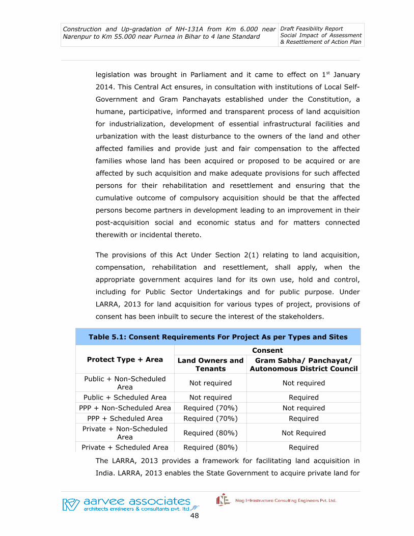
Construction and Up-gradation of NH-131A from Km 6.000 near Narenpur to Km 55.000 near Purnea in Bihar to 4 lane Standard
Draft Feasibility Report Social Impact of Assessment & Resettlement of Action Plan
legislation was brought in Parliament and it came to effect on 1st January
2014. This Central Act ensures, in consultation with institutions of Local Self-
Government and Gram Panchayats established under the Constitution, a
humane, participative, informed and transparent process of land acquisition
for industrialization, development of essential infrastructural facilities and
urbanization with the least disturbance to the owners of the land and other
affected families and provide just and fair compensation to the affected
families whose land has been acquired or proposed to be acquired or are
affected by such acquisition and make adequate provisions for such affected
persons for their rehabilitation and resettlement and ensuring that the
cumulative outcome of compulsory acquisition should be that the affected
persons become partners in development leading to an improvement in their
post-acquisition social and economic status and for matters connected
therewith or incidental thereto.
The provisions of this Act Under Section 2(1) relating to land acquisition,
compensation, rehabilitation and resettlement, shall apply, when the
appropriate government acquires land for its own use, hold and control,
including for Public Sector Undertakings and for public purpose. Under
LARRA, 2013 for land acquisition for various types of project, provisions of
consent has been inbuilt to secure the interest of the stakeholders.
Table 5.1: Consent Requirements For Project As per Types and Sites
Protect Type + AreaConsent
Land Owners and Tenants
Gram Sabha/ Panchayat/ Autonomous District Council
Public + Non-Scheduled Area
Not required Not required
Public + Scheduled Area Not required Required
PPP + Non-Scheduled Area Required (70%) Not required
PPP + Scheduled Area Required (70%) Required
Private + Non-Scheduled Area
Required (80%) Not Required
Private + Scheduled Area Required (80%) Required
The LARRA, 2013 provides a framework for facilitating land acquisition in
India. LARRA, 2013 enables the State Government to acquire private land for
JV 48
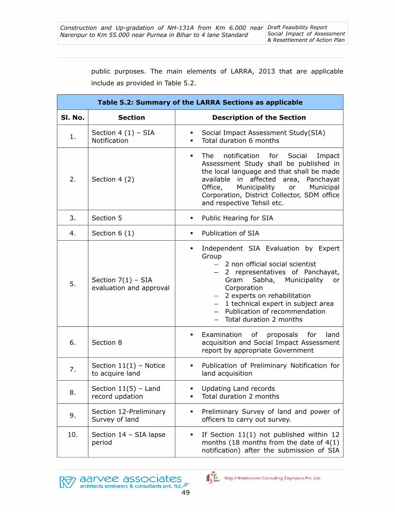
Construction and Up-gradation of NH-131A from Km 6.000 near Narenpur to Km 55.000 near Purnea in Bihar to 4 lane Standard
Draft Feasibility Report Social Impact of Assessment & Resettlement of Action Plan
public purposes. The main elements of LARRA, 2013 that are applicable
include as provided in Table 5.2.
Table 5.2: Summary of the LARRA Sections as applicable
Sl. No. Section Description of the Section
1. Section 4 (1) – SIA Notification
Social Impact Assessment Study(SIA) Total duration 6 months
2. Section 4 (2)
The notification for Social Impact Assessment Study shall be published in the local language and that shall be made available in affected area, Panchayat Office, Municipality or Municipal Corporation, District Collector, SDM office and respective Tehsil etc.
3. Section 5 Public Hearing for SIA
4. Section 6 (1) Publication of SIA
5.Section 7(1) – SIA evaluation and approval
Independent SIA Evaluation by Expert Group― 2 non official social scientist― 2 representatives of Panchayat,
Gram Sabha, Municipality or Corporation
― 2 experts on rehabilitation― 1 technical expert in subject area― Publication of recommendation― Total duration 2 months
6. Section 8 Examination of proposals for land
acquisition and Social Impact Assessment report by appropriate Government
7. Section 11(1) – Notice to acquire land
Publication of Preliminary Notification for land acquisition
8. Section 11(5) – Land record updation
Updating Land records Total duration 2 months
9. Section 12-Preliminary Survey of land
Preliminary Survey of land and power of officers to carry out survey.
10. Section 14 – SIA lapse period
If Section 11(1) not published within 12 months (18 months from the date of 4(1) notification) after the submission of SIA
JV 49

Construction and Up-gradation of NH-131A from Km 6.000 near Narenpur to Km 55.000 near Purnea in Bihar to 4 lane Standard
Draft Feasibility Report Social Impact of Assessment & Resettlement of Action Plan
Table 5.2: Summary of the LARRA Sections as applicable
Sl. No. Section Description of the Section
report under section 7, such report will lapse . Then fresh SIA to be done before acquisition under section 11.
Appropriate government shall have the power to extend the period of 12 months
11. Section 15(1) – Hearing of objections
Within 60 days from the date of 11(1) notification
12.
Section 16(1) – Preparation of R&R Scheme by Administrator (by state notification not below the rank of Joint Collector or Additional Collector or Dy. Collector or equivalent official of Revenue Department to be the Administrator for R&R)
After the publication of 11(1) notification by collector, Administrator for R&R shall conduct census survey for affected families.
13. Section 16(5) Public hearing of R&R Scheme
14. Section 16(6) Submission of draft R&R scheme to
collector
15. Section 17(1) Review of R&R scheme by Collector with
R&R committee
16.Section 18 – Approval of R&R scheme by Commissioner
Officer of the rank of Commissioner or Secretary of that Government
17.
Section 19(1) – Publication of declaration and summary of R&R
To be published within a period of 12 months from the notification under section 11(1) excluding stay or court order
18.Section 19(7) – Lapse of notification under section 11(1)
If no declaration is made within 12 months from the notification under section 11(1) excluding stay or court order
19. Section 21(1) Notice to person interested for taking
JV 50

Construction and Up-gradation of NH-131A from Km 6.000 near Narenpur to Km 55.000 near Purnea in Bihar to 4 lane Standard
Draft Feasibility Report Social Impact of Assessment & Resettlement of Action Plan
Table 5.2: Summary of the LARRA Sections as applicable
Sl. No. Section Description of the Section
possession.
20. Section 23 Land Acquisition Award by collector
21.Section 25 – Lapse of entire proceeding for acquisition
Award to be made within 12 months from the date of declaration under section 19. (Appropriate government shall have the power to extend the period with justification).
22. Section 26 The District Collector gets absolute right
to determine the Market Value of the Land
23. Section 30(3)
In addition to the market value of the land an amount of 12 % per annum needs to be given to land looser.
This award (additional amount 12%) would be considered for commencing period and from the date of publication of the notification of the social impact study till the award o
24. Section 31(1)
R&R award by collector Collector shall take possession after
ensuring 100% compensation payment and R&R entitlement or
Tendered within a period of 3 months for compensation and 6 months for R&R entitlements.
25. Section 38(1) Power to take possession of land to be acquired by Collector
26. Section 38(2) R&R process to be completed in all respect before displacing the AFs
27. Section 43(3)
Formulation, Execution and monitoring of R&R scheme shall vest in the Administrator under the direction and control of Government and Commissioner R&R.
28. Section 44(1) Appointment of R&R Commissioner
JV 51

Construction and Up-gradation of NH-131A from Km 6.000 near Narenpur to Km 55.000 near Purnea in Bihar to 4 lane Standard
Draft Feasibility Report Social Impact of Assessment & Resettlement of Action Plan
Table 5.2: Summary of the LARRA Sections as applicable
Sl. No. Section Description of the Section
29. Section 44(2)
Commissioner will be responsible for supervising the formulation of R&R schemes or plans and proper implementation of such schemes or plans.
30. Section 44(3)
Commissioner shall be responsible for post implementation social audit in consultation with Gram Sabha in Rural areas and municipality in urban areas.
31.
Section 45(1) Composition of R&R committee: (acquisition of equal to or more than 100 acres of land)
Chairman (Collector) Women representative residing in affected
area Representative of ST &SC residing in the
affected area Representative of NGO working in the
area Representative of Nationalized bank Land Acquisition officer of the project. Chairpersons of the Panchayats or
municipalities located in the affected area or their nominees.
Chairperson of the District Planning Committee or his nominee.
MP and MLA of the concerned area or their nominees.
Representative of the requiring body. Administrator for R&R as member-
convenor.
5.6 Scheduled Caste and Scheduled Tribes Orders (Amendment) Act, 2002
The Act provides for the inclusion in the lists of Scheduled Tribes (ST), of
certain tribes or tribal communities or parts of or groups within tribes or
tribal communities, equivalent names or synonyms of such tribes or
communities, removal of area restrictions and bifurcation and clubbing of
entries; imposition of area restriction in respect of certain castes in the lists
of Scheduled Castes (SC) and the exclusion of certain castes and tribes from
the lists of SCs and STs.
JV 52

Construction and Up-gradation of NH-131A from Km 6.000 near Narenpur to Km 55.000 near Purnea in Bihar to 4 lane Standard
Draft Feasibility Report Social Impact of Assessment & Resettlement of Action Plan
5.7 Various Provisions Under LARR Act-2013
Table: 5.3 – THE LAND ACQUISTION, REHABILATATION AND RESETTLEMENT ACT,2013
1. LAND ACQUISITION
In case of land acquisition the amount of compensation to be determined is that of the
value of the land +100 percent Solatium+12 percent additional market value from the
date of notification to taking over the possession or award whichever is higher. Market
value of land as mentioned under section 26 of LARRA Act-2013 needs to be
multiplied by the radial factor (based on the distance of project from urban
area as notified by the appropriate government- e.g multiplication of 2 in
Rural area and Multiplication of 1 in Urban area) plus value of assets attached
to land or building (mentioned in Section 29 of LARRA Act-2013) Plus
Solatium (solatium includes 100% market value multiplied by 2 plus value of
assets in Rural area and multiplied by 1 plus value of assets in urban area)
Example: Rural Area: If the Market value of land is Rs. 200, the final award will be
Rs.200 x2 +Solatium(100 % of Market Value x 2) =400+400=800 i.e 4 times of Market
Value I.e Rs.200x4=Rs.800
Urban Area: If the Market value of land is Rs. 500, the final award will be Rs.500 x1
+Solatium (100 % of Market Value x 1) =500+500=1000 i.e 2 times of Market Value
i.e Rs.500x2=Rs.1000.
2. PROVISION OF HOUSING UNITS IN CASE OF DISPLACEMENT
If a house is lost in rural areas, a constructed house shall be provided as per
the Indira Awas Yojana specifications. If a house is lost in urban areas, a
constructed house shall be provided, which will be not less than 50 sq mts in
plinth area.
The benefits listed above shall also be extended to any affected family which is without
homestead land and which has been residing in the area continuously for a period of
not less than three years preceding the date of notification of the affected area which
has been involuntarily displaced from such area:
JV 53

Construction and Up-gradation of NH-131A from Km 6.000 near Narenpur to Km 55.000 near Purnea in Bihar to 4 lane Standard
Draft Feasibility Report Social Impact of Assessment & Resettlement of Action Plan
Provided that any such family in urban areas which opts not to take the house offered,
shall get a one-time financial assistance for house construction, which shall not be less
than one lakh fifty thousand rupees:
Provided further that if any affected family in rural areas so prefers, the equivalent cost
of the house may be offered in lieu of the constructed house:
Provided also that no family affected by acquisition shall be given more than one house
under the provisions of this Act.
Explanation- The houses in urban areas may, if necessary, be provided in multi-storied
building complexes
3. CHOICE OF ANNUITY OR EMPLOYMENT
The appropriate Government shall ensure that the affected families are provided with
the following options:
(a) where jobs are created through the project, mandatory employment at a rate
not lower than the minimum wages provided for in any other law for the time being
in force, to at least one member per affected family in the project or arrange for a job
in such other project as may be required; or
(b) one time payment of five lakhs rupees per affected family; or
(c) annuity policies that shall pay not less than two thousand rupees per month
per family for twenty years, with appropriate indexation to the Consumer Price
Index for Agriculture Labourers.
4. SUBSISTENCE GRANTS
The appropriate Government shall ensure that the affected families are provided with
the following options:
Given monthly subsistence allowance equivalent to three thousand rupees per
month for a period of one year from the date of award. In addition to this amount,
the scheduled castes and the scheduled Tribes displaced from Scheduled Areas shall
receive an amount equivalent to fifty thousand rupees.
JV 54

Construction and Up-gradation of NH-131A from Km 6.000 near Narenpur to Km 55.000 near Purnea in Bihar to 4 lane Standard
Draft Feasibility Report Social Impact of Assessment & Resettlement of Action Plan
5. TRANSPORTATION COST
The appropriate Government shall ensure that the affected families are provided with
the following options:
Each affected family which is displaced shall get a one time financial assistance of fifty
thousand rupees as transportation cost for shifting of the family, building materials,
belongings and cattle.
6. CATTLE SHED/ PETTY SHOPS COST
Each affected family having cattle or having a petty shop shall get one-time financial
assistance of such amount as the appropriate Government may, by notification, specify
subject to a minimum of twenty-five thousand rupees for construction of cattle
shed or petty shop as the case may be.
7. ONE TIME GRANTS TO ARTISAN, SMALL TRADERS AND OTHERS
Each affected family of an artisan, small trader or self-employed person or an affected
family which owned non-agricultural land or commercial, industrial or institutional
structure in the affected area, and which has been involuntarily displaced from the
affected area due to land acquisition, shall get one-time financial assistance of such
amount as the appropriate Government may, by notification, specify subject to a
minimum of twenty-five thousand rupees.
8. ONE TIME RESETTLEMENT ALLOWANCE
Each affected family shall be given a one-time "Resettlement Allowance" of fifty
thousand rupees only.
9. STAMP DUTY REGISTRATION
(1). The stamp duty and other fees payable for registration of the land or house
allotted to the affected families shall be borne by the Requiring Body.
(2). The land for house allotted to the affected families shall be free from all
encumbrances.
(3). The land or house allotted may be in the joint names of wife and husband of the
affected family.
JV 55

Construction and Up-gradation of NH-131A from Km 6.000 near Narenpur to Km 55.000 near Purnea in Bihar to 4 lane Standard
Draft Feasibility Report Social Impact of Assessment & Resettlement of Action Plan
10. PROVISION OF INFRASTRUCTURAL AMENITIES
1. Roads within the resettled villages and an all weather road link to the nearest pucca road, passages and easement rights for all the resettled families be adequately arranged.
2. Proper drainage as well as sanitation plans executed before physical resettlement.
3. One or more assured sources of safe drinking water for each family as per the norms prescribed by the Government of India.
4. Provision of Drinking water for cattle.
5. Grazing land as per proportion acceptable in the State.
6. A reasonable number of Fair price Shops
7. Panchayat Ghars, as appropriate.
8. Village level Post Offices, as appropriate, which facilities for opening saving accounts.
9. Appropriate seed-cum-fertilizer storage facility if needed.
10. Efforts must be made to provide basic irrigation facilities to the agricultural land allocated to the resettled families if not from the irrigation project, then by developing a cooperative or under some Government scheme or special assistance.
11. All new villages established for resettlement of the displaced persons shall be provided with suitable transport facilities which must include public transport facilities through local bus services with the nearby growth centres/ urban localities.
12.Burial or cremation ground, depending on the caste communities at the site and their practices.
13. Facilities for sanitation, including individual toilet points.
14. Individual single electric connections(or connection through non-conventional sources of energy like solar energy), for each household and for public lighting.
15.Anganwadi's providing child and mother supplemental nutritional services.
16. School as per the provisions of the right of children to Free and Compulsory Education Act, 2009 (35 of 2009);
17. Sub-health centre within two kilo metres range.
18. Primary Health Centre as prescribed by the Government of India.
19. Playground for children.
20. One community centre for every hundred families.
21. Places of worship and chowpal/tree platform for every fifty families for community assembly, of numbers and dimensions consonant with the affected area.
22. Separate land must be earmarked for traditional tribal institutions.
23. The forest dweller families must be provided, where possible, with their traditional rights on non-timber forest produce and common property resources, if available close to teh new place of settlement and, in case any such family can continue their access or
JV 56
Construction and Up-gradation of NH-131A from Km 6.000 near Narenpur to Km 55.000 near Purnea in Bihar to 4 lane Standard
Draft Feasibility Report Social Impact of Assessment & Resettlement of Action Plan
entry to such forest or common property in the area close to the place of eviction, they must continue to enjoy their earlier rights to the aforesaid sources of livelihood.
24. Appropriate security arrangements must be provided for the settlement, if needed.
25. Veterinary service centre as per norms.
11.SPECIAL PROVISIONS FOR SCHEDULED CASTE AND SCHEDULED TRIBES
(1) In case of a project involving land acquisition on behalf of a Requiring Body which involves involuntary displacement of the Scheduled castes or the Scheduled Tribes families, a Development plan shall be prepared, in such form as may be prescribed, laying down the details of procedure for settling land rights due but not settled and restoring titles of tribals on alienated land by undertaking a special drive together with land acquisition.
(2) The Development Plan shall also contain a programme for development of alternate fuel, fodder and non-timber forest produce resources on non-forest lands within a period of five years sufficient to meet the requirements of tribal communities as well as the Scheduled castes.
(3) The concerned Gram Sabha or the Panchayats at the appropriate level in the Scheduled Areas under the Fifth Schedule to the Constitution or , as the case may be, Councils in the Sixth Scheduled Areas shall be consulted in all cases of land acquisition in such areas, including acquisition in case of urgency, before issue of a notification under this Act, or any other Central Act or a State Act for the time being in force as per the Provisions of the Panchayats (Extension to the Scheduled Areas) Act, 1996 (40 of 1996) and other relevant laws.
(4) In case of land being acquired from members of the Scheduled Castes or the Scheduled Tribes, at least one-third of the compensation amount due shall be paid to the affected families at the outset as first installment and the rest shall precede the taking over of the possession of the land.
(5) The Scheduled Tribes affected families shall be resettled preferably in the same Scheduled Area in a compact block, so that they can retain their ethnic, linguistic and cultural identity.
(6) The resettlement areas predominately inhabited by the Scheduled castes and the Scheduled Tribes shall get land, to such extent as may be decided by the appropriate Government, free of cost for community and social gatherings.
(7) In case of a project involving land acquisition on behalf of a Requiring body, the affected families belonging to the Scheduled Castes and the Scheduled Tribes resettled out of the district of acquisition will get twenty-five percent. Higher monetary benefits under Rehabilitation and Resettlement Scheme.
(8) Any alienation of tribal lands or lands belonging to members of the Scheduled Castes in disregard of the laws and regulations for the time being in force shall be treated as null and avoid; and in the case of acquisition of such lands, the rehabilitation and resettlement benefits shall be available to the original tribal land owners or land
JV 57

Construction and Up-gradation of NH-131A from Km 6.000 near Narenpur to Km 55.000 near Purnea in Bihar to 4 lane Standard
Draft Feasibility Report Social Impact of Assessment & Resettlement of Action Plan
owners belonging to the Scheduled Castes.
(9) The affected Scheduled Tribes, other traditional forest dwellers and the Scheduled castes families having fishing rights in a river or pond or dam in the affected area shall be given fishing rights in the reservoir area of the irrigation or hydel projects.
(10) Where the affected Scheduled Castes and Scheduled Tribes are relocated outside of the district then they shall be paid an additional twenty-five percent. Rehabilitation and Resettlement benefits to which they are entitled in monetary terms along with a one-time entitlement of fifty thousand rupees.
5.8 PRINCIPLES AND POLICIES ADOPTED FOR THE PROJECT
The core involuntary resettlement principles for this project are: (I) land
acquisition, and other involuntary resettlement impacts will be avoided or
minimized exploring all viable alternative sub-project designs; (ii) where
unavoidable, time-bound resettlement action plan (RAP) will be prepared and
PAPs will be assisted in improving or at least regaining their pre-project
standard of living;(iii) Consultation with PAPs on compensation, disclosure of
resettlement information to PAPs, and participation of in planning and
implementing sub-projects will be ensured; (iv) vulnerable groups will be
provided special assistance (v) payment of compensation to PAPs for
acquired assets at replacement rates; (vi) payment of compensation and
resettlement assistance prior to the construction contractor taking physical
acquisition of the land and prior to the commencement of any construction
activities; (vii) Provision of income restoration and rehabilitation; and (Viii)
establishment of appropriate grievance redress mechanisms.
5.9 ENTITLEMENT MATRIX
The broad entitlement matrix comprising the R & R compensation and
assistance is presented below. The titleholder PAPs will receive compensation
for land and assets, as decided by the competent authority.
The titleholders are entitled to receive compensation for land/assets at
replacement cost, R & R assistance and allowances for fees or other charges.
They should be given advance notice to harvest non-perennial crops, or
compensation for lost standing crops. They will have the right to salvage
JV 58
Construction and Up-gradation of NH-131A from Km 6.000 near Narenpur to Km 55.000 near Purnea in Bihar to 4 lane Standard
Draft Feasibility Report Social Impact of Assessment & Resettlement of Action Plan
material from existing structures.
The LARR-2013, represents a significant milestone in the development of a
systematic approach to address resettlement issues in India and closes
significantly the gap between Indian national policies and operational policy
of the World Bank. The National Highways Act, 1956 gives directives for the
acquisition of land in the public interest and provides benefits only to
titleholders.
Based on these, the following core involuntary resettlement principles are
applicable:
• Avoid or minimize land acquisition and involuntary resettlement impacts
by exploring all viable alternative designs;
• Where displacement is unavoidable, prepare time-bound RAP for PAPs so
that they are not worse off than the present socio-economic condition
after the implementation of the project. In other words, assist affected
persons in improving their former living standards and income earning
capacity with additional assistance to vulnerable groups;
• Ensure wide range of meaningful consultations with stakeholders
including likely PAPs on compensation, disclosure of resettlement
information, participation of PAPs in planning and implementation of the
resettlement program in order to suitably accommodate their inputs and
make rehabilitation and resettlement plan more participatory and broad
based;
• Facilitate harmonious relationship between the Executing Authority and
PAPs through mutual co-operation and interaction;
• Ensure payment of compensation and resettlement assistance prior to
taking over the possession of land and commencement of any
construction activities;
• Provision of rehabilitation assistance for loss of livelihood/income;
JV 59
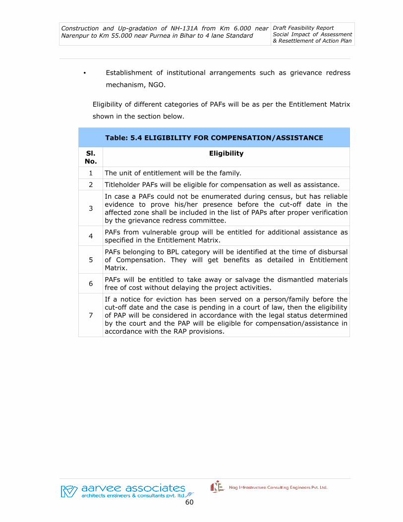
Construction and Up-gradation of NH-131A from Km 6.000 near Narenpur to Km 55.000 near Purnea in Bihar to 4 lane Standard
Draft Feasibility Report Social Impact of Assessment & Resettlement of Action Plan
• Establishment of institutional arrangements such as grievance redress
mechanism, NGO.
Eligibility of different categories of PAFs will be as per the Entitlement Matrix
shown in the section below.
Table: 5.4 ELIGIBILITY FOR COMPENSATION/ASSISTANCE
Sl. No.
Eligibility
1 The unit of entitlement will be the family.
2 Titleholder PAFs will be eligible for compensation as well as assistance.
3
In case a PAFs could not be enumerated during census, but has reliable evidence to prove his/her presence before the cut-off date in the affected zone shall be included in the list of PAPs after proper verification by the grievance redress committee.
4 PAFs from vulnerable group will be entitled for additional assistance as specified in the Entitlement Matrix.
5PAFs belonging to BPL category will be identified at the time of disbursal of Compensation. They will get benefits as detailed in Entitlement Matrix.
6PAFs will be entitled to take away or salvage the dismantled materials free of cost without delaying the project activities.
7
If a notice for eviction has been served on a person/family before the cut-off date and the case is pending in a court of law, then the eligibility of PAP will be considered in accordance with the legal status determined by the court and the PAP will be eligible for compensation/assistance in accordance with the RAP provisions.
JV 60

Table 5.5: Entitlement MatrixSl. No.
Category of Impact
Eligibility for Entitlement
LARR Act- 2013 ProvisionsRemarks
Entitlement Provisions1 2 3 4 5 6
1. Loss of Land Titleholder
• Market value of land. This will be determined as per Sections 26 to 29 of LARR Act 2013 by Collector.
• Amount equivalent to current stamp duty and registration charges on compensation amount for replacement of lost assets.
Applicable as per LARRA 2013.
― Market value will be determined by the Collector (under section 26-29). This as per First Schedule of the LARRA, 2013.
― All the entitlements for loss of land will be provided for each survey number based on ownership records to the rightful owner or their heirs as applicable.
Land Value factor Scale 1 to 2 based on the distance of project from urban area, as may be notified by appropriate government. Illustrative scale (0-10 km=1), (10-20=1.20), (20-30 km=1.40), (30-40 km=1.80), and (40-50 km=2).
― The proposed alignment passes through rural areas in Katihart district, Bihar state. Thus as per LARRA 2013 the
JV
61 61 61

Table 5.5: Entitlement MatrixSl. No.
Category of Impact
Eligibility for Entitlement
LARR Act- 2013 ProvisionsRemarks
Entitlement Provisions1 2 3 4 5 6
radial factor of 2 shall be applicable for calculating the market value of the land as per First Schedule of the Act.
Affected Family/Person
Land for land Not applicable Not applicable
2.Loss of other Immovable Assets Titleholder
Value of Assets attached to land or building
To be considered:• Standing crops, Trees,
Livelihood loss.
• As per LARRA 2013 under First Schedule Sl. No.2 (ref. Section 29).
3.
Loss of Land, Structure and other immovable assets (1+2)
Titleholder Solatium 100% on total compensation (including value of assets)
• As per LARRA 2013 - Under section 30(1) of the Act.
• The compensation is calculated for land and structures as applicable and the total of all considered before considering the solatium.
4. Loss of Land and Titleholder Additional 12% In addition to the market value of • As per LARRA
JV
62 62 62

Table 5.5: Entitlement MatrixSl. No.
Category of Impact
Eligibility for Entitlement
LARR Act- 2013 ProvisionsRemarks
Entitlement Provisions1 2 3 4 5 6
other assets on market value of land.
land, additional 12% per annum to be paid on such market value commencing on and from the date of publication of notification, till award or date of taking possession of land whichever is earlier.
2013. Under section 30 (3) of the Act.
5a. Loss of Structure Titleholder Provision of Housing unit or value of the lost structure
• If a house is lost in urban areas, a constructed house shall be provided, which will be not less than 50 sq. mts. in plinth area.
• Provided also that no family affected by acquisition shall be given more than one house under the provisions of this Act.
• Provided that any such family in urban areas which opts not to take the house offered, shall get a one-time financial assistance for house construction, which shall not be less than one lakh fifty thousand rupees. (Rs. 1,50,000.00)
• Provided further that if any affected family in rural areas so prefers, the equivalent cost of the house may be offered in lieu of the constructed house;
• Provided also that no family affected by acquisition shall be
• As per LARRA 2013 for Non-titleholders as given under Second Schedule of this Act.
JV
63 63 63
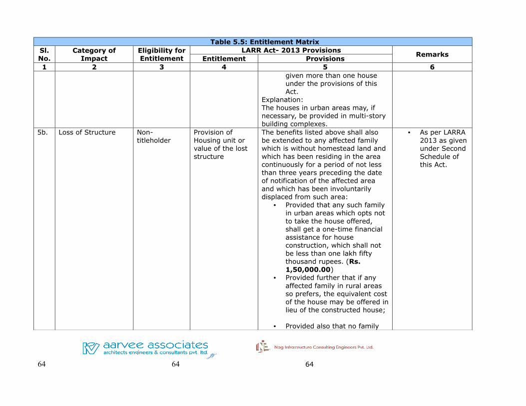
Table 5.5: Entitlement MatrixSl. No.
Category of Impact
Eligibility for Entitlement
LARR Act- 2013 ProvisionsRemarks
Entitlement Provisions1 2 3 4 5 6
given more than one house under the provisions of this Act.
Explanation:The houses in urban areas may, if necessary, be provided in multi-story building complexes.
5b. Loss of Structure Non-titleholder
Provision of Housing unit or value of the lost structure
The benefits listed above shall also be extended to any affected family which is without homestead land and which has been residing in the area continuously for a period of not less than three years preceding the date of notification of the affected area and which has been involuntarily displaced from such area:
• Provided that any such family in urban areas which opts not to take the house offered, shall get a one-time financial assistance for house construction, which shall not be less than one lakh fifty thousand rupees. (Rs. 1,50,000.00)
• Provided further that if any affected family in rural areas so prefers, the equivalent cost of the house may be offered in lieu of the constructed house;
• Provided also that no family
• As per LARRA 2013 as given under Second Schedule of this Act.
JV
64 64 64

Table 5.5: Entitlement MatrixSl. No.
Category of Impact
Eligibility for Entitlement
LARR Act- 2013 ProvisionsRemarks
Entitlement Provisions1 2 3 4 5 6
affected by acquisition shall be given more than one house under the provisions of this Act.
Explanation:The houses in urban areas may, if necessary, be provided in multi-story building complexes.
6a. Loss of LivelihoodAffected Family/Person
Annuity or Employment
(a) Job OR
(b) 5 lakh one-time payment OR
(c) Rs. 2000.00 per month for 20 years (with increment) (the option of availing a, b, or c shall be that of the affected family)
Where jobs are created through the project affected families will get after providing suitable training and skill development in the required field, make provision for employment at a rate not lower than the minimum wages provided for in any other law for the time being in force, to at least one member per affected family in the project or arrange for a job in such other project as may be required; or(b) onetime payment of five lakhs rupees (Rs.5,00,000) per affected family;or
(c) Annuity policies that shall pay not less than two thousand rupees per month per family for twenty years, with appropriate indexation to the Consumer Price Index for Agricultural Labourers. (Refer: http://labourbureau.nic.in).
• As per LARRA 2013 under Second Schedule of the Act.
JV
65 65 65

Table 5.5: Entitlement MatrixSl. No.
Category of Impact
Eligibility for Entitlement
LARR Act- 2013 ProvisionsRemarks
Entitlement Provisions1 2 3 4 5 6
6b. Loss of LivelihoodAffected Family/Person
Subsistence grant for displaced families for a period of one year (even if the families displaced due to land acquisition)
• Each affected family which is displaced from the land acquired shall be given a monthly subsistence allowance equivalent to three thousand rupees per month for a period of one year from the date of award. (Rs. 3000.00 per month for one year = 36,000.)
• As per LARRA under Second Schedule of the Act.
• In addition to this amount, the Scheduled Castes and the Scheduled Tribes displaced from Scheduled Areas shall receive an amount equivalent to fifty thousand rupees. (Rs. 50000.00).
• As per LARRA under Second Schedule of the Act.
7. StructureAffected Family/Person
Transportation cost for displaced families.
One time financial assistance of Rs. 50000.00 for shifting family, building material, belongings and cattle.
• As per LARRA 2013 under Second Schedule of the Act.
8. StructureAffected Family/Person
Commercial Establishments including Owners and Tenants
Each affected family having cattle or having a petty shop shall get one time financial assistance of such amount as the appropriate government may, by notification, specify subject to a minimum of Rs. 25000.00 for construction of cattle shed or petty shop as the case may be.
• As per LARRA under Second Schedule of the Act.
9. Livelihood Affected One time grant to Each affected family of an artisan, • As per LARRA
JV
66 66 66
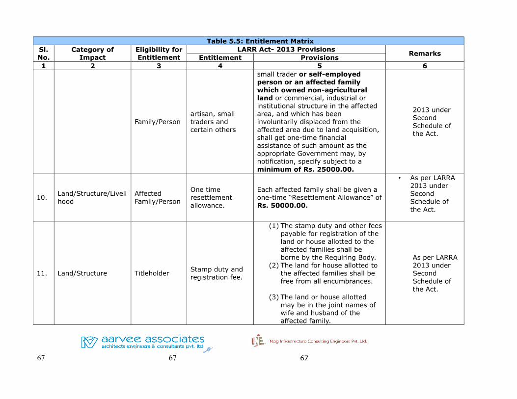
Table 5.5: Entitlement MatrixSl. No.
Category of Impact
Eligibility for Entitlement
LARR Act- 2013 ProvisionsRemarks
Entitlement Provisions1 2 3 4 5 6
Family/Personartisan, small traders and certain others
small trader or self-employed person or an affected family which owned non-agricultural land or commercial, industrial or institutional structure in the affected area, and which has been involuntarily displaced from the affected area due to land acquisition, shall get one-time financial assistance of such amount as the appropriate Government may, by notification, specify subject to a minimum of Rs. 25000.00.
2013 under Second Schedule of the Act.
10.Land/Structure/Livelihood
Affected Family/Person
One time resettlement allowance.
Each affected family shall be given a one-time “Resettlement Allowance” of Rs. 50000.00.
• As per LARRA 2013 under Second Schedule of the Act.
11. Land/Structure TitleholderStamp duty and registration fee.
(1) The stamp duty and other fees payable for registration of the land or house allotted to the affected families shall be borne by the Requiring Body.
(2) The land for house allotted to the affected families shall be free from all encumbrances.
(3) The land or house allotted may be in the joint names of wife and husband of the affected family.
As per LARRA 2013 under Second Schedule of the Act.
JV
67 67 67

Table 5.5: Entitlement MatrixSl. No.
Category of Impact
Eligibility for Entitlement
LARR Act- 2013 ProvisionsRemarks
Entitlement Provisions1 2 3 4 5 6
12.Land/Structure/Livelihood
Affected Family /Person
Any other unforeseen impacts
Any unforeseen impact would be addressed and mitigated as necessary by the Implementing Agency.
JV
68 68 68
Construction and Up-gradation of NH-131A from Km 6.000 near Narenpur to Km 55.000 near Purnea in Bihar to 4 lane Standard
Draft Feasibility Report Social Impact of Assessment & Resettlement of Action Plan
CHAPTER 6: STAKEHOLDERS' CONSULTATION
6.1 INTRODUCTION
Consultative procedures has been a critical but important front in the entire
social assessment process. Public consultations in social impact assessment
facilitates to make a rapport with the villagers in the project villages and provide
basic inputs. In this regard, the social assessment ensures the involvement of
local communities through participatory planning through structured
consultations would endorse and integrate important resettlement issues in the
project cycle.
For the purpose of stakeholder's consultation a team of social experts visited the
total stretch of package-II. In the process of information dissemination, collecting
relevant data and to acquaint with social requirements of the project,
government officials, key informants & knowledgeable person and other
stakeholders were consulted. The preliminary consultation meetings were
conducted in five villages.
The consultations were undertaken with various stakeholders at village levels for
sharing the information about the alignments. Prior intimation was given to the
villagers and the local public representatives e.g Sarpanch/Gram Mukhia of the
respective village to participate in the consultations. The village wise issues and
concern were discussed and suggestions made by the participants were recorded.
The range of discussion includes perception, attitude, benefit, problem,
suggestions recommendation and solution on social, economic, engineering
viability of the project.
In addition to bypass village level consultations, some preliminary meeting with
villagers, road users, shopkeepers, dwellers and other knowledgeable persons
were also conducted at village junction.
Almost all stakeholders' meeting were conducted in respective village Office. The
public representative or eminent person of the respective village presided the
meeting with Ararvee Associate representatives. Mr. Sobhan Patnaik, Mr.
JV 69

Construction and Up-gradation of NH-131A from Km 6.000 near Narenpur to Km 55.000 near Purnea in Bihar to 4 lane Standard
Draft Feasibility Report Social Impact of Assessment & Resettlement of Action Plan
Rajashekar and Mr. Gunjan Kumar participated in the meeting. The other
participants were revenue official, village elders, road side residents and probable
impacted families.
6.2 Issues Discussed
➢ The social team explained the need and technical details of the Package
-II road and need of bridge to the participants in terms of its length,
characteristics of the paved shoulder and need of bypass etc.
➢ For a better understanding about the proposed alignment with cross
sections the social team explained in detail to the PAPs.
➢ The land requirements for construction of the alignment and probable
impacts to the villagers was also discussed.
➢ The project’s efforts at minimizing land acquisition and promoting safety
measures were also discussed.
➢ Special attention for the weaker section of the society in general and
women in particular were also discussed.
➢ The broad principles and R & R mechanisms as per LARR Act-2013 was
also presented in detail.
The main objectives of undertaking these consultations were as follow:
➢ Dissemination of information on the proposed alignments
➢ To make affected persons aware of the project impacts and broad provisions
of the R&R policy.
➢ Discuss about the training requirements to enhance their skills & restore the
livelihood.
JV 70
Construction and Up-gradation of NH-131A from Km 6.000 near Narenpur to Km 55.000 near Purnea in Bihar to 4 lane Standard
Draft Feasibility Report Social Impact of Assessment & Resettlement of Action Plan
CHAPTER 7: REHABILITATION & RESETTLEMENT BUDGET
7.1 COST AND BUDGET
The budget is an indicative of outlays for the different expenditure categories.
The estimated budget for resettlement action plan for the project which include
land acquisition cost, structures cost and contingency is prepared as per the
Right to Fair Compensation and Transparency in Land Acquisition, Rehabilitation
and Resettlement Act-2013.The costs will be updated and adjusted to the
inflation rate as the project continues and in respect of more specific information
such as additional number of project affected people during the implementation,
unit cost will be updated if the findings of the district level committee on market
value assessment justify it.
The resettlement cost estimate for this project includes eligible compensation as
per entitlement matrix and support cost for RAP implementation. Contingency
provisions of about 10% of the total cost of R & R component is considered in the
budget mainly to meet the inflation and also to meet the cost of additional land
acquisition if required. The valuation of losses has been considered on the basis
of consultation with the revenue officials as well as with the project affected
population. Some of the major items of this R&R cost estimate are outlined below
and the R&R budget is presented in Table 7.1.
1. Compensation for Land
2. Compensation for structures and other immovable assets at their
replacement cost
3. Contingency cost
7.1.1 Compensation for Land
The total land need to be acquired for the proposed project is 49130 decimals.
The land price has been calculated on the basis of highest of circle rate for the
respective village.
The valuation of losses has been considered on the basis of consultation with the
JV 71

Construction and Up-gradation of NH-131A from Km 6.000 near Narenpur to Km 55.000 near Purnea in Bihar to 4 lane Standard
Draft Feasibility Report Social Impact of Assessment & Resettlement of Action Plan
revenue officials as well as project affected people. While the information
obtained from the revenue offices has been treated as actual transaction rate for
compensation and the information obtained from the affected people or villagers
is treated as the existing non official market value. The detail land account is
appended in Annexure 7.1
According to LARRA Act-2013, the market value of land as mentioned under
section 26 of act needs to be multiplied by the radial factor (based on the
distance of project from urban area as notified by the appropriate government-
e.g multiplication of 2 in Rural area and Multiplication of 1 in Urban area) plus
value of assets attached to land or building (mentioned in Section 29 of LARRA
Act-2013) Plus Solatium (solatium includes 100% market value multiplied by 2
plus value of assets in Rural area and multiplied by 1 plus value of assets in
urban area).
Table 7.1: Land Rate in Package-II Village
Sl. No. Village
To be Acquired Land
(in Decimal)
Land Rate (in Crore)
R & R Compensation
(in Crore)
1 Kutubpur 900 1.44 5.76
2 Pagalbari 1006 1.71 6.84
3 Manoharpur 958 4.79 19.16
4 Jagbati 521 0.78 3.12
5 Kumaripur 3082 6.39 25.56
6 Bhermara 303 0.62 2.48
7 Katihar 1318 8.12 32.48
8 Basantpur 964 1.74 6.96
9 Marangi 837 1.29 5.16
10 Raghunichak 64 0.09 0.36
11 Sirnia 2860 20.16 80.64
12 Chitauria 1239 4.06 16.24
13 Daharia 4399 31.24 124.96
14 Sahisia 633 0.56 2.24
15 Baigna 1899 3.86 15.44
16 Tiarpara 1433 95.72 382.88
17 Katihar 3112 27.98 111.92
18 Dalan 3456 16.9 67.6
JV 72
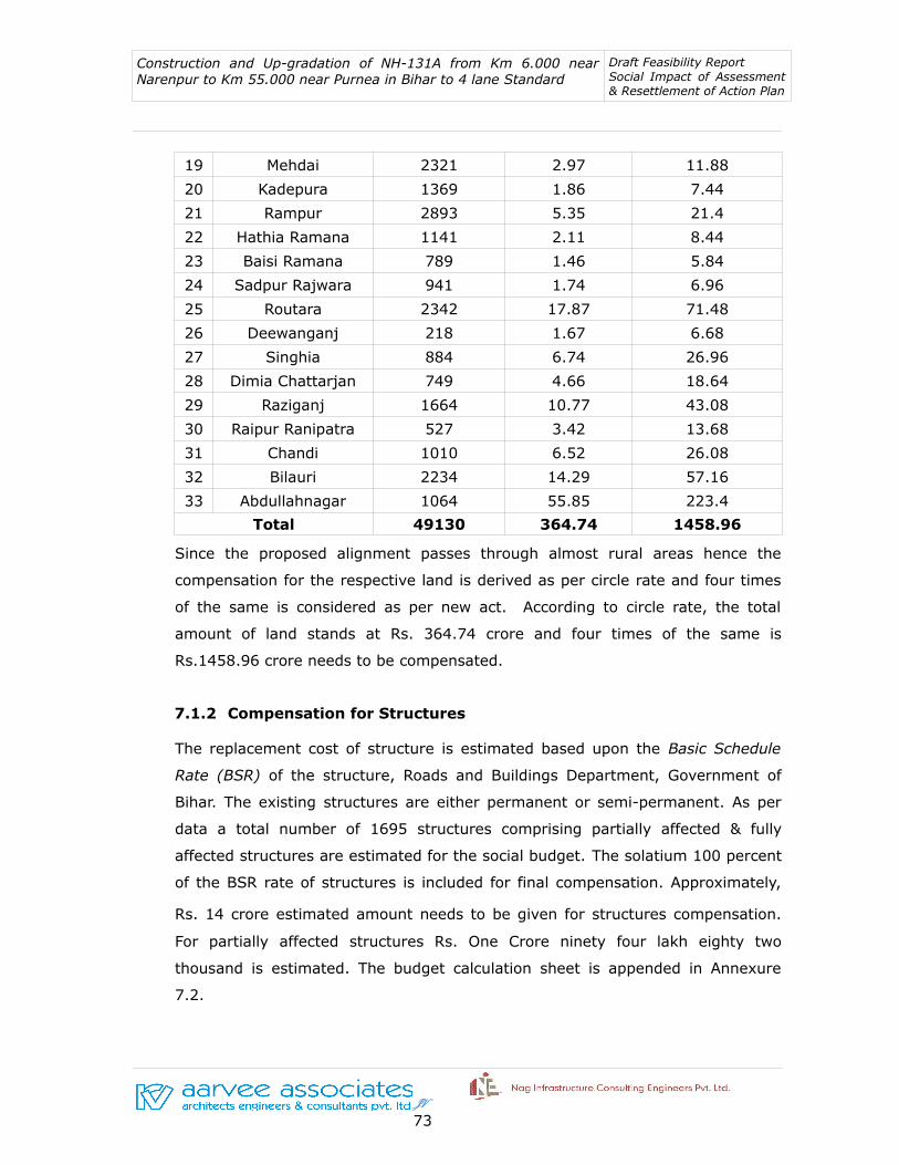
Construction and Up-gradation of NH-131A from Km 6.000 near Narenpur to Km 55.000 near Purnea in Bihar to 4 lane Standard
Draft Feasibility Report Social Impact of Assessment & Resettlement of Action Plan
19 Mehdai 2321 2.97 11.88
20 Kadepura 1369 1.86 7.44
21 Rampur 2893 5.35 21.4
22 Hathia Ramana 1141 2.11 8.44
23 Baisi Ramana 789 1.46 5.84
24 Sadpur Rajwara 941 1.74 6.96
25 Routara 2342 17.87 71.48
26 Deewanganj 218 1.67 6.68
27 Singhia 884 6.74 26.96
28 Dimia Chattarjan 749 4.66 18.64
29 Raziganj 1664 10.77 43.08
30 Raipur Ranipatra 527 3.42 13.68
31 Chandi 1010 6.52 26.08
32 Bilauri 2234 14.29 57.16
33 Abdullahnagar 1064 55.85 223.4
Total 49130 364.74 1458.96
Since the proposed alignment passes through almost rural areas hence the
compensation for the respective land is derived as per circle rate and four times
of the same is considered as per new act. According to circle rate, the total
amount of land stands at Rs. 364.74 crore and four times of the same is
Rs.1458.96 crore needs to be compensated.
7.1.2 Compensation for Structures
The replacement cost of structure is estimated based upon the Basic Schedule
Rate (BSR) of the structure, Roads and Buildings Department, Government of
Bihar. The existing structures are either permanent or semi-permanent. As per
data a total number of 1695 structures comprising partially affected & fully
affected structures are estimated for the social budget. The solatium 100 percent
of the BSR rate of structures is included for final compensation. Approximately,
Rs. 14 crore estimated amount needs to be given for structures compensation.
For partially affected structures Rs. One Crore ninety four lakh eighty two
thousand is estimated. The budget calculation sheet is appended in Annexure
7.2.
JV 73

Construction and Up-gradation of NH-131A from Km 6.000 near Narenpur to Km 55.000 near Purnea in Bihar to 4 lane Standard
Draft Feasibility Report Social Impact of Assessment & Resettlement of Action Plan
Table 7.2: Impact on Structures (Pvt., Govt. and Religious) in Package-II
Sl No. Structure
Partially Affected Fully Affected
Total R & R Compensation No.
Unit Rate (Rs.)
Total Amount
(Rs.)
R & R Compens
ation (Rs.)
No.Unit Rate (Rs.)
Total Amount
(Rs.)
R & R Compensati
on (Rs.)
Private Structure
1 Hut 137 5000 685000 1370000 368 50000 18400000 36800000 38170000
2 Residential Semi Pucca
335 10000 3350000 6700000 179 100000 17900000 35800000 42500000
3 Residential Pucca
219 20000 4380000 8760000 32 200000 6400000 12800000 21560000
4 Commercial Semi Pucca
62 10000 620000 1240000 86 100000 8600000 17200000 18440000
5 Petrol Bunk Canopy
1 0 0 0 4 200000 800000 1600000 1600000
6 Educational Inst. Pucca
10 20000 200000 400000 2 200000 400000 800000 1200000
7 Wells 1 50000 50000 100000 6 50000 300000 600000 700000
8 Toilet 3 2000 6000 12000 29 15000 435000 870000 882000
9 Compound Wall
80 2000 160000 320000 30 10000 300000 600000 920000
10 Room 4 5000 20000 40000 10 20000 200000 400000 440000
B. Govt. Structures
11 Govt. Office- Pucca
11 20000 220000 440000 19 200000 3800000 7600000 8040000
12 Bus Stop 0 0 0 0 13 0 0 0 0
13 Hospital 0 0 0 0 1 200000 200000 400000 400000
C. Religious Structures
14 Religious 5 10000 50000 100000 48 50000 2400000 4800000 4900000
Total Affected Structures
868 9741000 19482000 60135000 120270000 139752000
JV 74

Construction and Up-gradation of NH-131A from Km 6.000 near Narenpur to Km 55.000 near Purnea in Bihar to 4 lane Standard
Draft Feasibility Report Social Impact of Assessment & Resettlement of Action Plan
A total amount of approximately 1620 crore has been estimated for
implementation of Resettlement Action Plan. The NHAI guidelines recommend
that the compensation for the lost land and structures be paid through the
competent authority. For structures valuation, the concerned government
department may be requested to assess the value. The details of estimated
budget is presented in Table 7.3 below.
Table 7.3: Estimated Cost and R & R Budget
Sl. No
Item Unit Quantity Total Value (Rs.)
R& R Compensation
(Rs.)
A. R & R Compensation
1 Compensation for Land Decimal 49130 3647400000 14589600000
2 Compensation for Private Structures Number 1598 63206000 126412000
3 Compensation for Govt. Structures Number 44 4220000 8440000
4 Compensation for Religious Structures Number 53 2450000 4900000
Total 14729352000
B. Contingency
1 Contingency at 10 % of the Sub Total 1472935200
GRAND TOTAL (A+B) 16202287200
JV 75