chapter - 1 geologic setting and...
TRANSCRIPT
CHAPTER - 1
GEOLOGIC SETTING AND STRATIGRAPHY
1.1. HISTORICAL REVIEW
The Son-Mahanadi Gondwana belt extends for a little
more than 52 0 kms from the Talchir coalfield in Orissa/ through
Korba, ChirimirLand Bisrampur in Madhya Pradesh to Singrauli
Coalfield which lies partly in Madhya Pradesh and partly in
Uttar Pradesh, Eighteen Coalfields lie in this belt, each
being named after the geographical location of its coal bearing
formation. This belt covers an area about 25,000 sq. kms.
The study area lies on the western margin of the central
part of the Son-Mahanadi Gondwana belt and forms part of the
Korba and Hasdo-Arand Coalfields. It may be pointed out that
the Talchir sediments of the two coalfields form continuous
outcrops but the two coalfields are separately named because
the coal measures in the former lie around the town of Korba
and in the latter in the catchment area of the Hasdo and Arand
rivers.
According to Fox (1934, p. 224), Dr. V. Ball seems to
be the first geoscientist to have visited the coal bearing
area of what is known today as the Hasdo-Arand Coalfield in
1870-71. He further states that Lala Hira Lai of the Geological
10
Survey of India, examined this area in 1885-86 and 1887-88.
Fox (1934) investigated this area mainly from the point of
view of delineating the limits of the coal measures and
estimating the reserves of coal. He also analysed the coals
of the area and described some sections of the coal measures.
Ghosh (1953) investigated a part of this coalfield with
special reference to coal bearing strata. Puri (19 71) studied
the coal measures of the Hasdo-Arand Coalfields but hardly
touched upon the general geology of the area.
The coal bearing sediments of the area which constitutes
the Korba coalfield, were first recognised by Blanford (1870)
and, according to Pox (19 34, p. 232), examined by Lala Hira
Lai in 1886-87 who discovered several coal seams in the area.
Simpson (1922) and Fox (1934) made detailed investigations of
the coal seams in the area but gave no account of the general
geology as such. Ghosh (1971) summarised the geology of the
Korba area but the main emphasis of his work was on the coal
potential of this coalfield.
1.2. CLASSIFICATION OF GONDWANA ROCKS
The classification and stratigraphic nomenclature of
Gondwana sediments of India have been matters of debate and
revision from time to time, Sastry et al. (1977b)have reviewed
this aspect of the study of the Gondwanas.
11
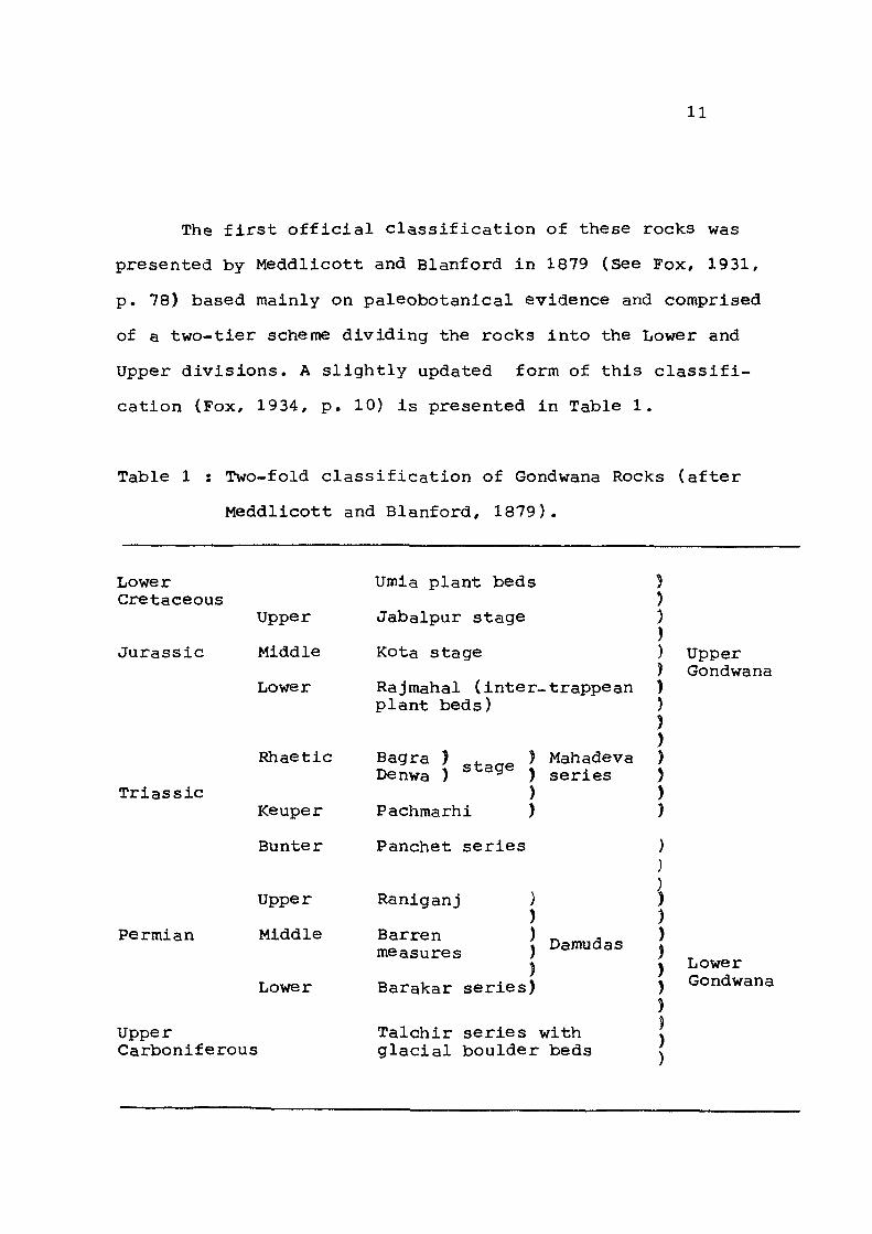
The first official classification of these rocks was
presented by Meddlicott and Blanford in 1879 (See Fox, 1931,
p. 78) based mainly on paleobotanical evidence and comprised
of a two-tier scheme dividing the rocks into the Lower and
Upper divisions. A slightly updated form of this classifi
cation (Fox, 1934, p. 10) is presented in Table 1.
Table 1 : Two-fold classification of Gondwana Rocks (after
Meddlicott and Blanford, 1879).
Lower Cretaceous
Jurassic
Triassic
Umia plant beds
Upper Jabalpur stage
Middle Kota stage
Lower Rajmahal (inter-trappean plant beds)
Rhaetic Bagra ) + . - , ) Mahadeva Denwa ) ^^^e j series
) Keuper Pachmarhi )
Bunter Panchet series
) ) 3 ) )
) ) ) ) ) ) ) )
Upper Gondwana
Permian
Upper
Middle
Lower
Upper Carboniferous
Raniganj ) )
Barren ) measures )
) Barakar series)
Damudas
Talchir series with glacial boulder beds
Lower Gondwana

12
In this classification, the Lower division is characterised
by 'Glossopteris flora* while the Upper is characterised by
•Ptilophyllam flora*. The two divisions are supposed to be
separated by an unconformity representing a paleontological
and stratigraphic break. This classification with some modifi
cations, has found favour with most workers in the field of
Gondwana geology (Oldham, 1893; Cotter, 1917; Pox, 1931, 1934;
Krishnan, 1968; Pascoe, 1959; Bose, 1966; Bakshi, 1967; Ghosh
and Basu, 1969; Kutty, 1969; Mitra, 1972; Casshyap and
Srivastava, 1986; etc.).
However, the presence of arid continental deposits
containing Triassic reptiles and amphibians in the middle
part of Gondwana sequence overlain and underlain by sediments
indicating humid and warm conditions and on the basis of
occurrence of Discroidium flora in Parsora Formation, led
Feistmantel (1882) to propose a three-fold classification
of Gondwana rocks comprising of the Lower, Middle and Upper
divisions and corresponding broadly to Permian, Triassic and
Jurassic System of Europe. He included the Panchet sub-division
within the 'transitional beds' whose flora show close affinity
to the Lower Gondwanas but appears lithologically more akin to
the Upper Gondwanas (Sastry et al., 1977a). The tripartite
classification has been adopted by Vredenburg (1910), Wadia
(1939), Saxena (1952, 1974), Lele (1962, 1964), Roychowdhry
et al (1973). The three-fold scheme of classification is
presented in Table 2.
13
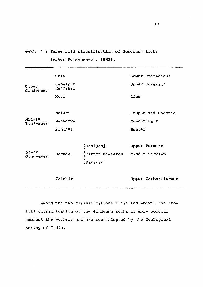
Table 2 s Three- fo ld c l a s s i f i c a t i o n of Gondwana Rocks
( a f t e r F e i s t m a n t e l , 1882) ,
Upper Gondwanas
Umia
Jabalpur Rajmahal
Kota
Lower Cretaceous
Upper Jurassic
Lias
Middle Gondwanas
Maleri
Mahadeva
Panchet
Keuper and Rhae t i c
Muschelkalk
Bunter
Lower Gondwanas
(Raniganj (
Damuda (Barren Measures ( (Barakar
Upper Permian
Middle Permian
Talchir Upper Carboniferous
Among the two classifications presented above, the two
fold classification of the Gondwana rocks is more popular
amongst the workers and has been adopted by the Geological
Survey of India.
14
1.3. STRATIGRAPHIC NOMENCLATURE
A review of the Gondwana literature shows that the
hierarchical terms used for the description of the various
large and small units of the stratigraphic column show no
uniformity. Thus terms like 'System', 'Series', 'Stage' and
'Sub-stage' have been used by Jowett (1925) whereas. Ball
U877), Feistmantel (1882), Hughes (1885), Oldham (1893),
have adopted the 'System' 'Series' 'Group' terminology.
However, with the publication of the code of Stratigraphic
Nomenclature of India (1971) much of the confusion has been
eliminated.
Two schemes of nomenclature, namely, lithostratigraphic
and time-stratigraphic, have been proposed in respect of the
Gondwanas but none of these has been accorded general acceptance,
sen (1965), Bakshi (1967), Casshyap (1970), Sengupta (1970),
Qidwai (1972), Khan (1978), Tewari (1980), Kumar (1984) and
Rais (1985) have followed the lithologic-stratigraphic scheme
while the time-stratigraphic (chrono-stratigraphic) scheme has
been adopted by Krishnan (1949), Wadia (1939), Ghosh and Basu
(1967). This situation is mainly due to the difficulty in
correlation resulting from the wide variation of lithological
and biological content, closed nature of the basins and great
aereal distance of one basin from the other.
15
The lithostratigraphic scheme of classification has been
adopted in this work. The time-stratigraphic terms like 'System',
•Series' and 'Stage' presently in usage have been replaced by
lithostratigraphic terms such as 'Supergroup', 'Group',
'Formation' and 'Member'.
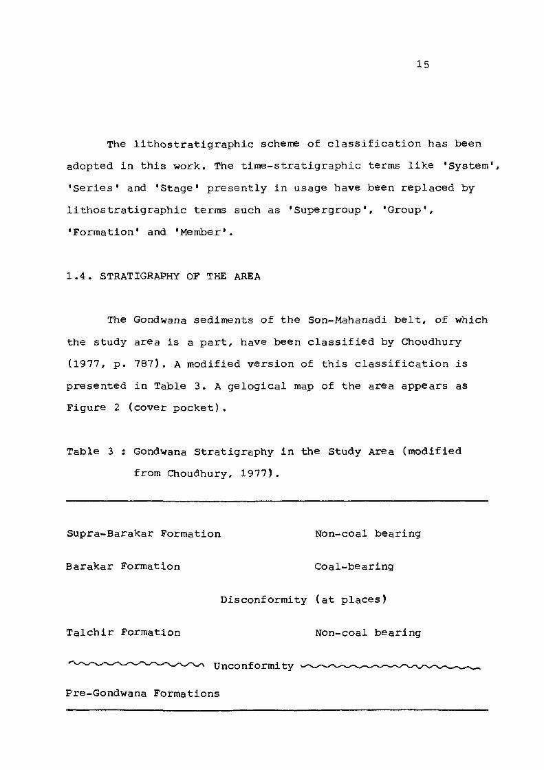
1.4. STRATIGRAPHY OF THE AREA
The Gondwana sediments of the Son-Mahanadi belt, of which
the study area is a part, have been classified by Choudhury
(1977, p. 787), A modified version of this classification is
presented in Table 3. A gelogical map of the area appears as
Figure 2 (cover pocket).
Table 3 : Gondwana Stratigraphy in the Study Area (modified
from Choudhury, 1977).
Supra-Barakar Formation Non-coal bearing
Barakar Formation Coal-bearing
Disconformity (at places)
Talchir Formation Non-coal bearing
'"''••-''•'''"-'••'''''''•'-••''"^ U n c o n f o r m i t y
Pre-Gondwana Formations
16
1.4.1. Pre-Gondwana Formations
1.4.1.1. Archaean Rocks of Baslnal Area
The basement rocks on which the Gondwana sediments
actually rest in the study area comprise of granite and
granite-gneiss of Archaean age. In the southern part of the
area in the vicinity of Korba, the granites are coarse grained
and often pass imperceptibly into a coarse grained, well-
foliated, porphyritic biotite gneiss. North-west of this area,
true granites are rare and are replaced by fine grained, well
foliated granite gneiss.
The Archaean basement rocks occur continuously all along
the edge of the Gondwana basin in this area. They also crop
out extensively as long, narrow, big and small, NW-SE trending
ridges from within the Talchir rocks indicating that the floor
on which the Talchir sediments were deposited was highly uneven
and traversed by long and high ridges running parallel to the
general NW-SE trend of the main basin and consisting of granite-
gneisses .
1.4.1.2. Archaean Rocks of Extra Basinal Area
A little distance from the western edge of the Gondwana
basin, lying to the south, south-west and west of the area
17
under investigation, cropout a variety of Archaean meta-
sedimentary rocks occurring in patches. These are believed
to belong to the 'Chilpi Series' and comprise of 'massive
quartzite, quartz-schist, mica-schist and slate interbedded
with greenstones and trappoid rocks (Wadia, 1939; Pascoe,
1965; Krishnan, 1968).
In the Sambhalpur-Raigarh-Sarangarh region, south and
south_east of the present area, lie a series of highly meta
morphosed rocks of the same age and comprise of garnetiferous
gneiss, quartz-garnet schist, mica schist and quartzite.
1.4.1,3. Purana Rocks of Extra Basinal Area
The rocks of the great Chattisgarh basin of Purana age
lying with a profound unconformity on the Archaean rocks,
outcrop extensively to the south and southwest of the study
area. The rocks are undisturbed, practically unmetamorphosed
and comprise of a sequence of conglomerates, sandstones, shales
and limestones. These rocks have been correlated with the
Cuddapahs of South India by Wadia (1939, p. 118) and Pascoe
(1965, p. 376) and with the Vindhyans by Krishnan (1968, p. 189).
1.4.2. Talchir Formation
The name 'Talchir Series' (hereinafter called the
18
Talchir Formation as per the Code of Stratigraphic Nomenclature
of India/ 1971) was given by W.T. Blanford, H.F. Blanford and
W. Theobald (1856) after the earstwhile princely state of
Talchir in Orissa, where the rocks were first described.
This Formation is the oldest in the Gondwana sequence
and lies directly over the Archaean granites and gneisses,
the junction between the two being profoundly unconformable
(Plate-I, Figs. 1 & 2) in most cases or faulted at some
localities (Plate-I, Fig. 3).
The rocks of this Formation are very different from the
rest of the Gondwana formations in many respects. Green colour
is very typical of all the lithounits constituting this
Formation. However, the most characteristic and genetically
important feature of the Talchirs is the presence of two
diamictite units - one at the base resting on the Archaean
basement and the other higher up in the sequence.
Basically seven lithofacies makeup the Talchir sequence in
the study area. These are massive (basal) diamictite, stratified
(upper) diamictite, mudstone with or without dropstone, massive
sandstone, cross-stratified channel sandstone, interbedded shale
and siltstone/sandstone and splintery shale. The massive diamicti
te unit is poorly sorted and contain clasts of different sizes,
roundness, sphericity and lithology which float in an abundant
quantity of clayey detrital matrix. The stratified diamictite is
very similar to the massive diamictite but differs from it in its
EXPLANATION OF PLATE I
Figure 1 Massive diamictite at the base of Talchir sequence lying unconformably over fine grained foliated granite gneiss of Archaean age.
Note the near horizontal contact between the two.
Jhulna nala section.
Figure 2 Massive diamictite at the base of Talchir sequence resting conformably over sheared, vertically foliated granite gneiss.
Note steep contact between the diamictite and gneiss.
Ambikapur Road section about 5 km from Marhai.
Figure 3 Faulted contact between Talchir sandstone (fore ground) and granite gneiss (back ground). The sandstone dip into the gneiss.
Hasdo river section, about 6 km from bridge on Ambikapur road.
Figure 4 Contact of cross-stratified Talchir sandstone with Barakar sandstone.
Note that horizontally disposed Barakar sandstone rests on very low dipping Talchirs indicating slight disconformity between the two.
Kharpari nala section about 20 m upstream from road bridge.
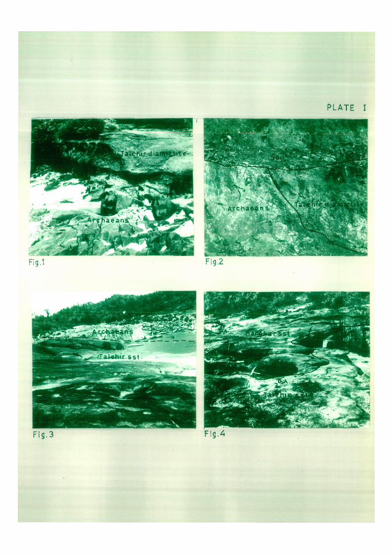
PLATE I
.1* i v jf- aak^eit. ..i^Urt.-F ig .3 Fig 4
19
stratigraphic position, textural attributes of the enclosed
clasts, lesser quantity and sandy nature of matrix and its
crudely stratified structure. Occasionally, small lenses of
fine grained cross-stratified sandstones occur within this
unit. The three sandstone lithofacies are very similar to each
other in their textural and compositional characters. They are
all fine to very fine grained and range in composition from
sub-litharenite to sub~ark;ose. The mudstones are massive units
and often contain occasional dropstones. The shales are
splintery bluish or blackish green in colour.
1.4.3. Barakar Formation
The rocks of the Barakar Formation in the study area
rest on the Talchir rocks with a very slight angular unconfor
mity at some places (Plate-I, Fig. 4) and often overlap on to
the Archaean basement rocks. The former feature is clearly
seen m the Kharpari nala section where the Talchir lithofacies
are truncated agaxnst the Barakar rocks while an overlap
relationship is obvious in the Kotri nala section about 7,5
kms west of Pali town (Fig. 2).
The Barakars comprise of grey coloured, coarse to medium
grained, feldspathlc sandstones which are thick-bedded and
generally profusely cross-stratified. The sandstones are
inter-bedded with micaceous sandy shales, carbonaceous shales
and coal seams.
20
1.4.4. Supra-Barakar Formation
Rocks resting conformably on the Barakars, but devoid
of coal/ occur in a small patch in the eastern central part
of the study area about 18 km north of Korba. They have been
tentatively correlated with the Kamthi Formation of Godavari
Valley (= Raniganj Formation of Damodar Valley) by Roy et al.,
(1962) .
The Supra~Barakar rocks form high flat topped geomorphic
features, Lithologically they are very similar to the underlying
Barakars and comprise of grey sandstones and conglomerates with
intercalated shale bands.
1.5. STRUCTURE OF THE AREA
The structural nature of the Gondwana basins has been a
matter of controversy ever since they were first studied.
Blanford et al. (1856) and Oldham (1893) believed that the
Gondwana coalfields occupy areas of depression which were
further accentuated as deposition proceeded. Simpson and
Ball (1922/ p. 2) opined that the Gondwana coalfields represent
'basins of original deposition* at some places while at others
they are preserved due to faulting. Greisbach (1880); jowett
(1925); Gee (1932, 1941), Ahmad (1960) and Krishnan (1968)
have expressed the opinion that originally the Gondwana basins
21
most have extended over larger tracts. Pox (1934, p. 23), on
the other hand believes that these basins were block faulted
and that the Gondwana sediments were deposited in these well
defined structural basins. Wadia (1939, p. 166) also holds
generally the same view but concedes that "some of the boundary
faults may be of post-Gondwana age*. Pascoe (1959) seems
entirely to agree with this view.
According to Chatterjee and Ghosh (1967), major faulting
in the Gondwana basins started during the Barakar sedimentation
and not earlier. In the opinion of Chaudhury (1977, p. 789)
"the sedimentation attributes of Talchir Formation indicate
the total absence of any tectonic imprint on the sedimentary
framework of the basins and the 'a-tectonic' embryonic character
of the area during Talchir deposition is well established". He
further suggests that during the succeeding Damuda times, there
was a complex role of tectonism within the basinal area.