chaffey dam augmentation and safety upgrade …
TRANSCRIPT
Infrastructure
and
Environment
Level 12, 141 Walker Street North Sydney NSW 2060 Australia Telephone: 61 2 8456 7200 Facsimile: 61 2 8923 6877 www.worleyparsons.com WorleyParsons Services Pty Ltd ABN 61 001 279 812
301015-02980-LET-0007_31052013.doc 1 30th May 2013
Ref: 301015-02980 File: 301015-02980-LET-0007_31052013.doc
Mr Alexander Scott Planning Officer Infrastructure Projects Department of Planning and Infrastructure GPO Box 39 SYDNEY NSW 2000 31 May 2013
Dear Alexander,
CHAFFEY DAM AUGMENTATION AND SAFETY UPGRADE PROJECT (SSI 5039)
This letter has been prepared to respond to Commonwealth and State Government Agencies’ comments on the Preferred Infrastructure Report (PIR) for the abovementioned project. The letter is accompanied by:
Revised Figures
o Figure 1 - Revised dam wall works area
o Figure 2 - Project Layout, incorporating revised dam wall works area
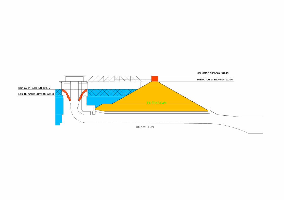
o Figure 3 - Dam wall raising cross-section, showing existing and new crest elevations
Revised Addendum Flora and Fauna Impact Assessment
Revised Offset Plan
Letter from State Water regarding the proposed payment framework and funding contribution for the Booroolong Frog Offset.
1. BACKGROUND
On 15 March 2013, the Chaffey Dam Augmentation and Safety Upgrade PIR was submitted to the Department of Planning and Infrastructure (the Department) by WorleyParsons, on behalf of State Water. An Addendum Flora and Fauna Impact Assessment, including an Offset Plan, was provided as an appendix to the PIR.
The PIR was subsequently referred by the Department to relevant State Government agencies. The PIR was also referred to the Commonwealth Department of Sustainability, Environment, Water, Population and Communities (SEWPaC) as the Project has previously been declared a controlled action under the Environment Protection and Biodiversity Act, 1999 (EPBC Act).
Comments on the PIR were received from the following State agencies:
Heritage Council of NSW, dated 26 March 2013
Trade and Investment, Crown Lands, dated 2 April 2013
Namoi Catchment Management Authority (CMA), dated 5 April 2013
Office of Environment and Heritage (OEH), dated 5 April 2013
Department of Primary Industries, Fisheries NSW and NSW Office of Water, dated 17 April 2013
Department of Planning and Infrastructure, dated 19 April 2013
SEWPaC provided comments to the Department in a letter dated 12 April 2013.
301015-02980-LET-0007_31052013.doc 2 31 May 2013
2. RESPONSE TO PIR COMMENTS
2.1 Flora and Fauna
A Revised Addendum Flora and Fauna Impact Assessment and a Revised Offset Plan have been prepared by nghenvironmental to incorporate additional information, maps and graphs to address the biodiversity comments raised by SEWPaC, the Department, OEH and Namoi CMA. A Response to Submissions Table forms Appendix B of the Revised Addendum Report and contains a summary of the response to each agency’s comment. Detailed information in relation to each comment is contained in the Revised Addendum Report or the Revised Offset Plan, where relevant.
The Revised Addendum Flora and Fauna Impact Assessment and the Revised Offset Plan replace the Addendum Flora and Fauna Impact Assessment and Offset Plan submitted with the PIR.
The Revised Addendum Flora and Fauna Impact Assessment, incorporating the Revised Offset Plan, is provided as Attachment A.
A letter from State Water regarding the proposed payment framework and funding contribution for the Booroolong Frog Offset is provided as Attachment B.
2.2 Modification to Works at the Dam Wall and Construction Method
Subsequent to submission of the PIR, progression of detailed design and discussions with contractors has resulted in two proposed minor amendments to the Project, namely to the dam wall works area and to the dam wall construction method.
The southern extent of the dam wall works area, as presented in the Project Environmental Impact Statement (EIS) and PIR, is proposed to be increased in size by 1.5 ha which would increase the overall works area from 33.6 ha to 35.1 ha. The additional area is currently occupied by cleared land and exotic vegetation. No environmental impacts additional to those assessed in the EIS and PIR are anticipated to occur.
The revised dam wall works area is shown in Figure 1. The Project Layout, incorporating the revised dam wall works area, is shown in Figure 2.
The dam wall construction method is also proposed to be modified. The dam wall raising will now be achieved by the construction of a vertical reinforced earth wall that is to be constructed on the crest of the existing dam wall. The construction of the reinforced earth wall will not require any excavation of the dam wall toe or any placement of rocks on the downstream embankment. The wall raising and access will be limited to the crest of the dam wall.
In addition, the revised construction approach will mean that there is no longer any requirement to raise the morning glory spillway access bridge and piered platform.
A cross-section of the revised design for the dam wall raising, showing the existing and new crest elevations, is presented in Figure 3.
Changes to the Project construction methodology, facilities and anticipated equipment, as presented in Table 4-1 of the EIS, are shown below in Table 1. Items shown in strikethrough (strikethrough) are no longer required. Items shown in bold are additional to the information presented in the EIS.
301015-02980-LET-0007_31052013.doc 3 31 May 2013
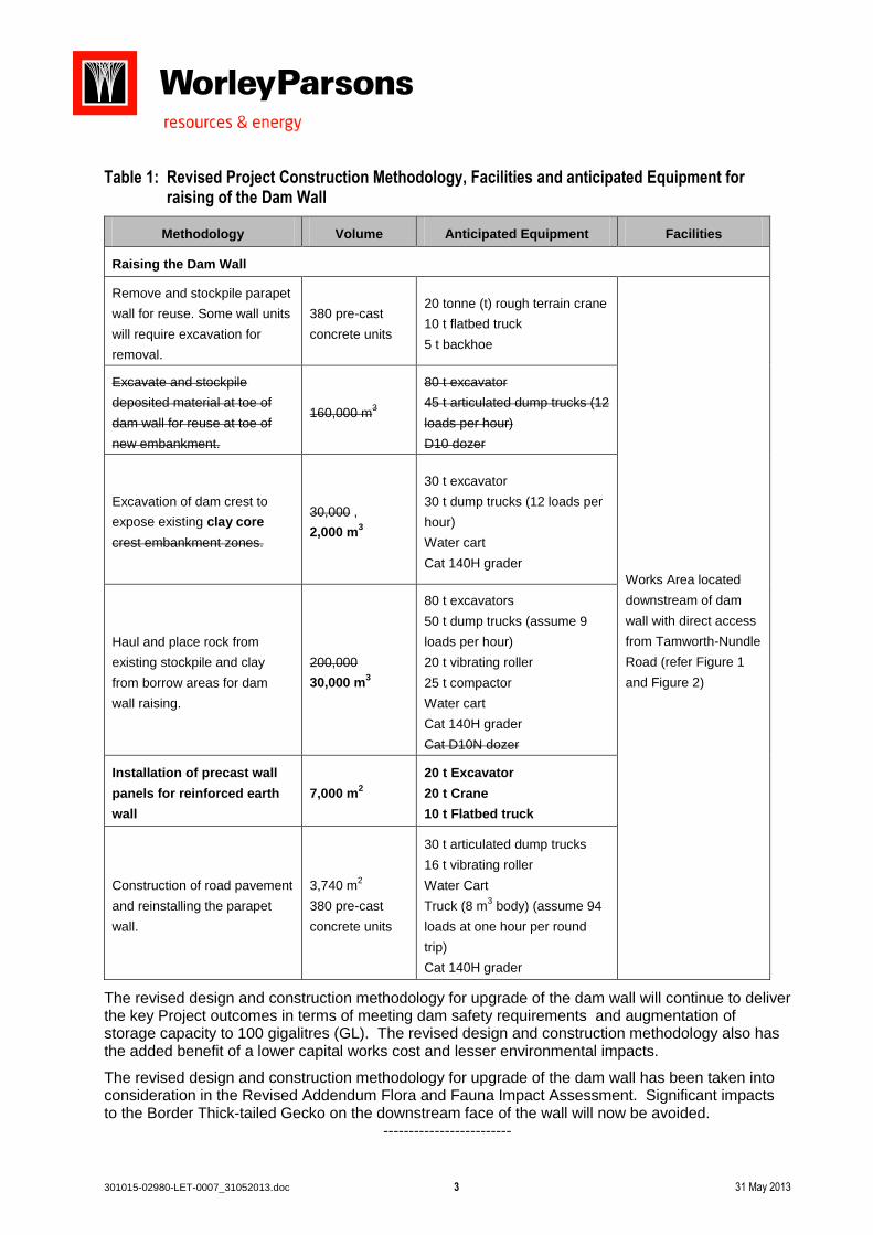
Table 1: Revised Project Construction Methodology, Facilities and anticipated Equipment for raising of the Dam Wall
Methodology Volume Anticipated Equipment Facilities
Raising the Dam Wall
Remove and stockpile parapet
wall for reuse. Some wall units
will require excavation for
removal.
380 pre-cast
concrete units
20 tonne (t) rough terrain crane
10 t flatbed truck
5 t backhoe
Works Area located
downstream of dam
wall with direct access
from Tamworth-Nundle
Road (refer Figure 1
and Figure 2)
Excavate and stockpile
deposited material at toe of
dam wall for reuse at toe of
new embankment.
160,000 m3
80 t excavator
45 t articulated dump trucks (12
loads per hour)
D10 dozer
Excavation of dam crest to
expose existing clay core
crest embankment zones.
30,000 ,
2,000 m3
30 t excavator
30 t dump trucks (12 loads per
hour)
Water cart
Cat 140H grader
Haul and place rock from
existing stockpile and clay
from borrow areas for dam
wall raising.
200,000
30,000 m3
80 t excavators
50 t dump trucks (assume 9
loads per hour)
20 t vibrating roller
25 t compactor
Water cart
Cat 140H grader
Cat D10N dozer
Installation of precast wall
panels for reinforced earth
wall
7,000 m2
20 t Excavator
20 t Crane
10 t Flatbed truck
Construction of road pavement
and reinstalling the parapet
wall.
3,740 m2
380 pre-cast
concrete units
30 t articulated dump trucks
16 t vibrating roller
Water Cart
Truck (8 m3 body) (assume 94
loads at one hour per round
trip)
Cat 140H grader
The revised design and construction methodology for upgrade of the dam wall will continue to deliver the key Project outcomes in terms of meeting dam safety requirements and augmentation of storage capacity to 100 gigalitres (GL). The revised design and construction methodology also has the added benefit of a lower capital works cost and lesser environmental impacts.
The revised design and construction methodology for upgrade of the dam wall has been taken into consideration in the Revised Addendum Flora and Fauna Impact Assessment. Significant impacts to the Border Thick-tailed Gecko on the downstream face of the wall will now be avoided.
-------------------------

301015-02980-LET-0007_31052013.doc 4 31 May 2013
It is considered that the EIS, PIR and the supplementary information contained within this response provide the information required to address all Commonwealth and State Agencies’ comments.
Should you have any questions regarding this information, please contact Nicole Cowlishaw on (02) 8456 7209.
Kind regards,
Sofie Mason-Jones Principal Environmental Planner WorleyParsons Enclosed: Figure 1: Revised dam wall works area Figure 2: Project Layout, incorporating revised dam wall works area Figure 3: Dam wall raising cross-section, showing existing and new crest elevations Attachment A: Revised Addendum Flora and Fauna Impact Assessment, incorporating the
Revised Offset Plan Attachment B: State Water Letter
Infrastructure
and
Environment
Level 12, 141 Walker Street North Sydney NSW 2060 Australia Telephone: 61 2 8456 7200 Facsimile: 61 2 8923 6877 www.worleyparsons.com WorleyParsons Services Pty Ltd ABN 61 001 279 812
301015-02980-LET-0007_31052013.doc 31 May 2013
FIGURE 1
Revised dam wall works area

PROPOSED EMBANKMENT CRESTEXISTING EMBANKMENT UPSTREAM SLOPE
EXISTING EMBANKMENT CREST
PROPOSED CONCRETE WALLEXISTING AUXILIARY SPILLWAY
PROPOSEDMORNING GLORY
SPILLWAY RAISING
HARD ROCK STOCKPILESTO BE USED FOR
THE AUGMENTATION WORK
HARD ROCK STOCKPILES TOBE USED FOR THE
AUGMENTATION WORK
BORROW AREA FORCORE
MATERIALS
BORROW AREAFOR COREMATERIALS
AREA TO BE TRIMMEDFOR DIRECTION OF FLOOD
WATER FROM AUXILIARYSPILLWAY TO THE RIVER
PROPOSEDFUSE-PLUG 2PROPOSED
FUSE-PLUG 1
EXISTINGEMBANKMENT
DOWNSTREAM SLOPE
EXISTING ACCESS BRIDGE TO MORNING GLORY
SPILLWAY TO BE RAISEDPROPOSED EXTENSION
OF ACCESS BRIDGE
EXISTING MORNING GLORYSPILLWAY OUTLET CHANNEL
322000
322000
323000
323000
6531
000
6531
000
LEGEND
Location: ..\301015-02980 CHAFFEY DAM\03Project\Workspace\_SKT\301015-02980-GIS-SKT-006
Produ
ced By
: rya
n.wrig
ht@wo
rleyp
arson
s.com
- Ge
omati
cs
REF :
DATE :
REV : A2
21 May 2013
301015-02980-GIS-SKT-006.mxdSTATE WATERCUSTOMER :
1:7,500SCALE :RWAUTHOR :
CHAFFEY DAM AUGMENTATION AND SAFETY UPGRADE
DAM WALL CONSTRUCTION AREA
Copyright ©WorleyParsons Services Pty Ltd
ABN 61 001 279 812Datum : GDA94
Map Grid of AustraliaZone 56
±
0 0.2 0.40.1
Kilometres @ A4
LOCATION PLAN
±
DAM WALL SITE LAYOUT AREASWORKS AREAEXISTING FULL SUPPLY LEVELNEW FULL SUPPLY LEVELNEW 1 IN 100 YEAR FLOOD LEVELNEW PROBABLE MAX FLOOD LEVELCADASTRE (05.07.2012)
INFORMATION ONLYNOT TO BE USED
FOR CONSTRUCTIONAERIAL IMAGERY BY GEOSPECTRUM (TAKEN 29.08.2011).
301015-02980-LET-0007_31052013.doc 31 May 2013
FIGURE 2
Project Layout, incorporating revised dam wall works area

TAMWORTH
NUNDLE PORTMACQUARIE
NEWCASTLE
Source: Esri, DigitalGlobe, GeoEye, i-cubed, USDA, USGS, AEX, Getmapping, Aerogrid, IGN, IGP, andthe GIS User Community
320000
320000
325000
325000
6525
000
6525
000
6530
000
6530
000
LOCATION PLAN
REF :
DATE :
REV : A2
21 May 2013
301015-02980-GIS-SKT-012.mxd CUSTOMER :
1:30,000SCALE :RWAUTHOR :
LEGEND
WORKS AREAREVISED WORKS AREASEXISTING FULL SUPPLY LEVELNEW FULL SUPPLY LEVELNEW 1 IN 100 YEAR FLOOD LEVELNEW PROBABLE MAX FLOOD LEVEL
Location: \301015-02980 CHAFFEY DAM\03Project\Workspace\_SKT\301015-02980-GIS-SKT-012
Produ
ced B
y: rya
n.wrig
ht@wo
rleyp
arson
s.com
- Ge
omati
cs
Copyright ©WorleyParsons Services Pty Ltd
ABN 61 001 279 812
Datum : GDA94Map Grid of Australia
Zone 56
0 0.5 1 1.5 20.25
Kilometres @ A3
±
CHAFFEY DAM AUGMENTATION AND SAFETY UPGRADE
REVISED PROJECT LAYOUT
STATE WATER
± ±
INFORMATION ONLYNOT TO BE USED
FOR CONSTRUCTIONAERIAL IMAGERY BY GEOSPECTRUM (TAKEN 29.08.2011). ALTERNATE IMAGERY BY ESRI
301015-02980-LET-0007_31052013.doc 31 May 2013
FIGURE 3
Dam wall raising cross-section, showing existing and new crest elevations
301015-02980-LET-0007_31052013.doc 31 May 2013
ATTACHMENT A
Revised Addendum Flora and Fauna Impact Assessment, incorporating the Revised Offset Plan

unit 18, level 3, 21 mary st surry hills nsw 2010 australia t (02) 8202 8333
www.nghenvironmental.com.au e [email protected]
room 15, 341 havannah st (po box 434)
bathurst nsw 2795 australia
0488 820 748
suite 1, 216 carp st (po box 470)
bega nsw 2550 australia
t 61 2 6492 8333
suite 1, 39 fitzmaurice st (po box 5464)
wagga wagga nsw 2650 australia
t (02) 6971 9696
unit 17, 27 yallourn st (po box 1037)
fyshwick act 2609 australia
t (02) 6280 5053
37 peron ave (po box 1037)
dunsborough wa 6281 australia
(08) 9759 1985
Revised Addendum Report
TERRESTRIAL AND AQUATIC FLORA AND FAUNA IMPACT ASSESSMENT
ADDENDUM REPORT CHAFFEY DAM AUGMENTATION AND SAFETY
UPGRADE
MAY 2013
unit 18, level 3, 21 mary st surry hills nsw 2010 australia t (02) 8202 8333
www.nghenvironmental.com.au e [email protected]
room 15, 341 havannah st (po box 434)
bathurst nsw 2795 australia
0488 820 748
suite 1, 216 carp st (po box 470)
bega nsw 2550 australia
t 61 2 6492 8333
suite 1, 39 fitzmaurice st (po box 5464)
wagga wagga nsw 2650 australia
t (02) 6971 9696
unit 17, 27 yallourn st (po box 1037)
fyshwick act 2609 australia
t (02) 6280 5053
37 peron ave (po box 1037)
dunsborough wa 6281 australia
(08) 9759 1985
Document Verification
Project Title: TERRESTRIAL AND AQUATIC FLORA AND FAUNA
IMPACT ASSESSMENT ADDENDUM REPORT CHAFFEY
DAM AUGMENTATION AND SAFETY UPGRADE
Project Number: 2400
Project File Name: Revised Addendum Report Chaffey Dam Augmentation and Safety Upgrade
300513 Final
Revision Date Prepared by (name) Reviewed by (name) Approved by (name)
Revised
Addendu
m Report
Final
30/05/13 Freya Gordon
Dave Maynard
Raphael Morgan
Jacqui Coughlan Nick Graham-Higgs
nghenvironmental prints all documents on environmentally sustainable paper including paper made from bagasse (a by-
product of sugar production) or recycled paper.
nghenvironmental is a registered trading name of NGH Environmental Pty Ltd; ACN: 124 444 622.
ABN: 31 124 444 622
TERRESTRIAL AND AQUATIC FLORA AND FAUNA IMPACT ASSESSMENT ADDENDUM REPORT CHAFFEY DAM
AUGMENTATION AND SAFETY UPGRADE
2400 Revised Addendum Report Final i
CONTENTS
1 INTRODUCTION ........................................................................................................................ 1
1.1 BACKGROUND ......................................................................................................................................1
1.1.1 History of the Project ............................................................................................................................. 1
1.1.2 Project Location and Layout .................................................................................................................. 2
1.2 STUDY SITE AND STUDY AREA DESCRIPTION .......................................................................................3
1.3 SCOPE OF THIS REPORT ........................................................................................................................3
1.4 REDUCTION IN WORKS AREAS .............................................................................................................5
1.5 ASSESSMENT OF ALTERNATIVES ..........................................................................................................7
2 SUBJECT SPECIES .................................................................................................................... 10
2.1 BOOROOLONG FROG ........................................................................................................................ 10
2.1.1 Conservation Status ............................................................................................................................. 10
2.1.2 Degree of Protection in Reserves ........................................................................................................ 11
2.1.3 Revised impact assessment ................................................................................................................. 12
2.1.4 Current Surveys ................................................................................................................................... 12
2.1.5 Methods............................................................................................................................................... 13
2.1.6 Results ................................................................................................................................................. 13
2.1.7 Current Population Status ................................................................................................................... 14
2.1.8 Habitat ................................................................................................................................................. 17
2.1.9 Potential Impacts ................................................................................................................................. 19
2.1.10 Management measures for Booroolong Frog ..................................................................................... 20
2.1.11 Expected or Predicted Effectiveness of proposed mitigation .............................................................. 21
2.2 QUEENSLAND BLUEGRASS ................................................................................................................ 21
2.2.1 Survey Methods ................................................................................................................................... 21
2.2.2 Results ................................................................................................................................................. 24
2.2.3 Potential impacts and mitigation ......................................................................................................... 24
2.3 BORDER THICK-TAILED GECKO .......................................................................................................... 24
2.3.1 Habitat and Population at Chaffey Dam .............................................................................................. 25
2.3.2 Potential Impacts ................................................................................................................................. 25
2.3.3 Mitigation and management measures for the Border Thick-tailed Gecko ........................................ 27
2.3.4 Expected or Predicted Effectiveness of proposed mitigation .............................................................. 27
2.4 MURRAY COD .................................................................................................................................... 28
2.4.1 Populations and Habitat ...................................................................................................................... 28

TERRESTRIAL AND AQUATIC FLORA AND FAUNA IMPACT ASSESSMENT ADDENDUM REPORT CHAFFEY DAM
AUGMENTATION AND SAFETY UPGRADE
2400 Revised Addendum Report Final ii
2.4.2 Potential Flow Regime and Water Quality (Oxygen and Temperature) Impacts on Murray Cod and its
Habitat Downstream of Chaffey Dam ............................................................................................ 32
2.4.3 Potential Cold Water Pollution Impacts Downstream of Chaffey Dam Following Augmentation ...... 38
2.4.4 Cold Water Pollution Management ..................................................................................................... 39
2.4.5 Mitigation Measures ............................................................................................................................ 40
2.5 THREATENED FLORA SPECIES AND VEGETATION COMMUNITIES .................................................... 46
2.5.1 EPBC listed White Box-Yellow Box-Blakely's Red Gum Grassy Woodland and Derived Native
Grassland ........................................................................................................................................ 46
2.5.2 TSC listed White Box-Yellow Box-Blakely's Red Gum Woodland ......................................................... 47
2.5.3 Small Snake Orchid and Euphrasia arguta ........................................................................................... 49
2.5.4 Justification for not targeting Eucalyptus rubida subsp. barbigerorum, Thesium australe and
Bothriochloa biloba as part of this assessment. ............................................................................ 49
2.6 THREATENED SPECIES HABITAT AVAILABILITY .................................................................................. 50
2.6.1 Historical threatened species data ...................................................................................................... 50
3 REVISED IMPACT ASSESSMENT ............................................................................................... 52
3.1 SUMMARY OF POSITIVE CHANGE IN OVERALL IMPACT ................................................................... 52
3.2 SUMMARY OF POTENTIAL IMPACTS ON THREATENED SPECIES ....................................................... 52
4 MITIGATION AND MANAGEMENT MEASURES ......................................................................... 55
5 CONCLUSION ......................................................................................................................... 55
6 REFERENCES ........................................................................................................................... 57
APPENDIX A REVISED THREATENED SPECIES IMPACT ASSESSMENT ............................................... A-I
APPENDIX B RESPONSE TO SUBMISSIONS ON PIR (RECEIVED APRIL 2013) ..................................... B-I
APPENDIX C BOOROOLONG FROG DISTRIBUTION ON PEEL RIVER (2013 DATA) ............................. C-I
APPENDIX D OFFSET PLAN ........................................................................................................... D-I
TABLES
Table 1-1 Change to the size of the Project Works Areas .............................................................................. 5
Table 1-2 Comparison of area of vegetation to be inundated under alternative scenarios of storage
capacity ........................................................................................................................................................... 9
Table 2-1 Booroolong Frog survey results, summer 2013 ...........................................................................14
Table 2-2 Queensland Bluegrass targeted survey locations and effort .......................................................22
Table 2-3 Stocking of Murray Cod (fry or fingerling) within Chaffey Dam and the Peel River upstream and
downstream of the impoundment. Data provided by DPI (fisheries) on 1 May 2013. ................................30
TERRESTRIAL AND AQUATIC FLORA AND FAUNA IMPACT ASSESSMENT ADDENDUM REPORT CHAFFEY DAM
AUGMENTATION AND SAFETY UPGRADE
2400 Revised Addendum Report Final iii
Table 3-1 – Revised Assessment of impact to Subject Species .....................................................................52
Table 3-2 Revised areas of impact based on updated and more specific data on area of impact for roads
and bridges. ..................................................................................................................................................54
FIGURES
Figure 1-1. Project layout ................................................................................................................................ 6
Figure 1-2 Comparison of Full Supply Level under the three storage capacity scenarios of 80 GL, 100 GL
and 120 GL. ..................................................................................................................................................... 8
Figure 2-1 Sex and age class of Booroolong Frogs recorded in summer 2013 (NWES, 2013) .....................15
Figure 2-2 Booroolong Frog life stages from Chaffey Dam (Map 1) upstream (to Map 8) (NWES, 2013) ...15
Figure 2-3 Booroolong Frog abundance and distribution upstream of Chaffey Dam summer 2013 (Data
provided by NWES). Refer to Appendix C for a more detailed breakdown of the data. .............................16
Figure 2-4 Microhabitat selection by Booroolong Frogs surveyed in summer 2013 in the Peel River and
Wombramurra Creek, from Chaffey Dam (Map 1) upstream (to Map 8) (source NWES 2013). ..................18
Figure 2-5 Queensland Bluegrass targeted survey locations .......................................................................23
Figure 2-6 Revised construction methodology on the Chaffey Dam wall ....................................................26
Figure 2-7 Location of previous Murray Cod records, extent of downstream and upstream impacts and
habitat of Murray Cod ..................................................................................................................................29
Figure 2-8 Location of important population of Murray Cod relative to Chaffey Dam and downstream
limit of potential impact. ..............................................................................................................................32
Figure 2-9 Impact of river regulation at Piallamore (all year flow) (NSW Office of Water 2010a) ..............34
Figure 2-10 Recorded water temperatures downstream and upstream of the dam between July 2011 and
March 2012 (State Water Corporation 2013). ..............................................................................................39
Figure 2-11 Vegetation Communities within the study area ........................................................................48
TERRESTRIAL AND AQUATIC FLORA AND FAUNA IMPACT ASSESSMENT ADDENDUM REPORT CHAFFEY DAM
AUGMENTATION AND SAFETY UPGRADE
2400 Revised Addendum Report Final 1
1 INTRODUCTION
1.1 BACKGROUND
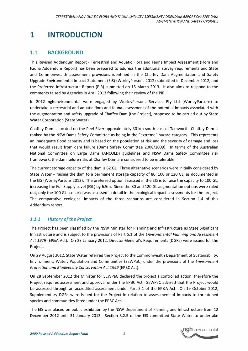
This Revised Addendum Report - Terrestrial and Aquatic Flora and Fauna Impact Assessment (Flora and
Fauna Addendum Report) has been prepared to address the additional survey requirements and State
and Commonwealth assessment provisions identified in the Chaffey Dam Augmentation and Safety
Upgrade Environmental Impact Statement (EIS) (WorleyParsons 2012) submitted in December 2012, and
the Preferred Infrastructure Report (PIR) submitted on 15 March 2013. It also aims to respond to the
comments raised by Agencies in April 2013 following their review of the PIR.
In 2012 nghenvironmental were engaged by WorleyParsons Services Pty Ltd (WorleyParsons) to
undertake a terrestrial and aquatic flora and fauna assessment of the potential impacts associated with
the augmentation and safety upgrade of Chaffey Dam (the Project), proposed to be carried out by State
Water Corporation (State Water).
Chaffey Dam is located on the Peel River approximately 30 km south-east of Tamworth. Chaffey Dam is
ranked by the NSW Dams Safety Committee as being in the “extreme” hazard category. This represents
an inadequate flood capacity and is based on the population at risk and the severity of damage and loss
that would result from dam failure (Dams Safety Committee 2008/2009). In terms of the Australian
National Committee on Large Dams (ANCOLD) guidelines and NSW Dams Safety Committee risk
framework, the dam failure risks at Chaffey Dam are considered to be intolerable.
The current storage capacity of the dam is 62 GL. Three alternative scenarios were initially considered by
State Water – raising the dam to a permanent storage capacity of 80, 100 or 120 GL, as documented in
the EIS (WorleyParsons 2012). The preferred option assessed in the EIS is to raise the capacity to 100 GL,
increasing the Full Supply Level (FSL) by 6.5m. Since the 80 and 120 GL augmentation options were ruled
out, only the 100 GL scenario was assessed in detail in the ecological impact assessments for the project.
The comparative ecological impacts of the three scenarios are considered in Section 1.4 of this
Addendum report.
1.1.1 History of the Project
The Project has been classified by the NSW Minister for Planning and Infrastructure as State Significant
Infrastructure and is subject to the provisions of Part 5.1 of the Environmental Planning and Assessment
Act 1979 (EP&A Act). On 23 January 2012, Director-General’s Requirements (DGRs) were issued for the
Project.
On 29 August 2012, State Water referred the Project to the Commonwealth Department of Sustainability,
Environment, Water, Population and Communities (SEWPaC) under the provisions of the Environment
Protection and Biodiversity Conservation Act 1999 (EPBC Act).
On 28 September 2012 the Minister for SEWPaC declared the project a controlled action, therefore the
Project requires assessment and approval under the EPBC Act. SEWPaC advised that the Project would
be assessed through an accredited assessment under Part 5.1 of the EP&A Act. On 19 October 2012,
Supplementary DGRs were issued for the Project in relation to assessment of impacts to threatened
species and communities listed under the EPBC Act.
The EIS was placed on public exhibition by the NSW Department of Planning and Infrastructure from 12
December 2012 until 31 January 2013. Section 8.2.5 of the EIS committed State Water to undertake

TERRESTRIAL AND AQUATIC FLORA AND FAUNA IMPACT ASSESSMENT ADDENDUM REPORT CHAFFEY DAM
AUGMENTATION AND SAFETY UPGRADE
2400 Revised Addendum Report Final 2
additional surveys during summer 2012/2013 to further inform the flora and fauna impact assessment for
the Project in relation to Queensland Bluegrass (Dichanthium setosum) and the Booroolong Frog (Litoria
booroolongensis).
Submissions on the EIS, relevant to the flora and fauna impact assessment for the Project, were received
from the Namoi Catchment Management Authority (Namoi CMA), the NSW Office of Environment and
Heritage (OEH) and the Department of Planning and Infrastructure.
Section 8.2.6 of the EIS committed State Water to prepare and submit an Offset Plan with the Preferred
Infrastructure Report or Response to Submissions report. Following agency comments in April 2013, a
revised Offset Plan has been provided in Appendix D.
A response to submissions made on the PIR in relation to flora and fauna is provided at Appendix B. The
response references relevant sections of this revised Flora and Fauna Addendum Report where additional
information is provided. Substantial detailed information is contained within the Terrestrial and Aquatic
Flora and Fauna Assessment prepared by nghenvironmental (2012) and contained in the EIS as Appendix
8. These documents are referred to within this report as follows:
1. WorleyParsons (2012). Chaffey Dam Augmentation and Safety Upgrade Environmental Impact
Statement State Significant Infrastructure. Report prepared for State Water.
2. nghenvironmental (2012). Terrestrial and Aquatic Flora and Fauna Impact Assessment.
Appendix 8 of WorleyParsons (2012).
Following submission of the EIS and PIR, some modifications have been made to the Project to reduce its
environmental impact.
1.1.2 Project Location and Layout
The Project comprises the augmentation and safety upgrade of the existing Chaffey Dam (
Figure 1-1). The proposed works will result in an increase in the FSL of 6.5 m and an increase in the
permanent storage capacity from 62 GL to 100 GL.
The Project is proposed to be carried out by State Water and includes the following components:
• Augmentation of the dam to 100 GL at FSL and safety upgrade, through raising of the dam
wall and modification of the existing spillways. The safety upgrade works will involve
raising the dam wall by 8.4 m to increase the flood storage capacity of the reservoir.
Reconfiguration of the auxiliary spillway fuseplug is also proposed to enable staged
discharge of floodwaters. Raising the morning glory spillway by 6.5 m will enable
augmentation to 100 GL.
• Realignment of roads will be required due to the increased FSL, but will be limited to
parts of Tamworth-Nundle Road, Rivers Road, Western Foreshore Road and bridges,
limited to Bowling Alley Point Bridge, Hydes Creek Bridge and a culvert crossing at Silver
Gully.
• Relocation of some facilities at the Bowling Alley Point Recreation Area and the South Bowlo
Fishing Club is also required due to the increased FSL. As part of the Project, the South Bowlo
Fishing Club facilities will be relocated to higher ground, proximate to their existing locations.
• The Project will result in an increase to the FSL of approximately 185 ha surrounding the
existing reservoir and an additional footprint of up to 38 ha for development of new roads
and bridges.

TERRESTRIAL AND AQUATIC FLORA AND FAUNA IMPACT ASSESSMENT ADDENDUM REPORT CHAFFEY DAM
AUGMENTATION AND SAFETY UPGRADE
2400 Revised Addendum Report Final 3
1.2 STUDY SITE AND STUDY AREA DESCRIPTION
Chaffey Dam is located on the Peel River within the upper Namoi River catchment in north-east NSW.
The dam is approximately 6 km south of the town of Woolomin, and approximately 13 km north of the
town of Nundle.
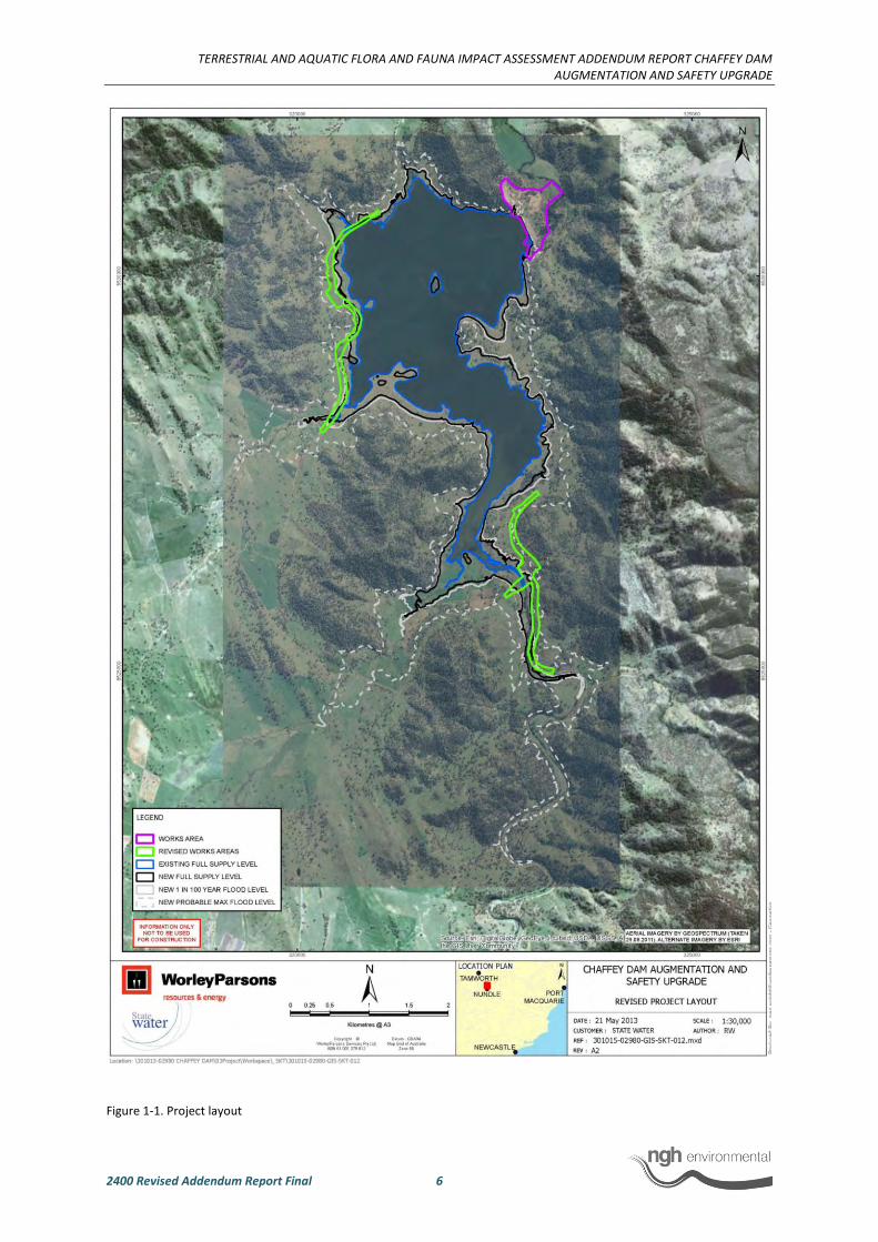
The study site is defined as the areas directly affected by the Project, and includes those areas within the
augmented FSL and works areas (
Figure 1-1). The works areas include the roads and bridges to be realigned or relocated along Western
Foreshore Road, Tamworth-Nundle Road and Rivers Road, as well as the area impacted by works to the
dam wall, morning glory spillway and auxiliary spillway.
The study area centres on Chaffey Dam (
Figure 1-1) and is defined as the study site plus surrounding areas which were investigated in order to
undertake the impact assessment. The study area encompassed a 1 km buffer from the new FSL.
The Project is located on land comprising Crown land, freehold, leasehold, road reserve and State Water
acquired land. Existing land uses around Chaffey Dam include:
• The existing dam and reservoir
• Recreational and open space land uses, including:
o Bowling Alley Point Recreation Area (managed by the Bowling Alley Point Recreation
Reserve Trust)
o South Bowlo Fishing Club
o Nundle Fishing Club
o Dulegal Arboretum (established by the now dissolved Dulegal Arboretum Association
and opened in 1982, this area is noted for its scientific and recreational value, however
it is no longer being maintained)
• Land under private ownership and leasehold, including rural residential properties and land used
for grazing and dairy farming
• Roads and bridges
• State Water administration and maintenance facilities and Storage Custodian’s residence
1.3 SCOPE OF THIS REPORT
At the time of writing the Terrestrial and Aquatic Flora and Fauna Impact Assessment and the EIS, the
likely level of impact on two threatened species (Booroolong Frog and Queensland Bluegrass) was
uncertain due to a lack of data that was based on recent surveys conducted in an appropriate season.
The EIS committed to undertaking additional surveys to clarify the extent of likely impact based on
current data, and the offsetting requirements for these species. The PIR with the Flora and Fauna
Addendum report was submitted to the Department of Planning and Infrastructure in February 2013, and
submissions in relation to biodiversity were received from Namoi CMA, OEH and the Department of
Planning and Infrastructure in April 2013.
This report provides an analysis of the updated survey data and a revised and complete assessment of
potential impact. It also addresses the biodiversity comments raised from the Agency review of the PIR.

TERRESTRIAL AND AQUATIC FLORA AND FAUNA IMPACT ASSESSMENT ADDENDUM REPORT CHAFFEY DAM
AUGMENTATION AND SAFETY UPGRADE
2400 Revised Addendum Report Final 4
In addition, further information is provided on the level of impact and proposed mitigation for the
threatened Border Thick-tailed Gecko (Uvidicolus sphyrurus) and Murray Cod (Maccullochella peelii
peelii). The Border Thick-tailed Gecko inhabits the dam wall, and due to a change in Project
methodology, impacts to the Border Thick-tailed Gecko have been greatly reduced, therefore a revised
impact assessment for this species has been provided.
These four species (Booroolong Frog, Queensland Bluegrass, Border Thick-tailed Gecko and Murray Cod)
are referred to in this report as the Subject Species.
Therefore the primary aims of this Flora and Fauna Addendum Report are to:
• Provide updated data on the abundance and distribution of the Booroolong Frog within
the study area, listed as Endangered under both the Threatened Species Conservation Act
1995 (TSC Act) and EPBC Act
• Determine the likelihood of occurrence of Queensland Bluegrass within the study site,
listed as Vulnerable under both the TSC Act and EPBC Act
• Determine the potential impacts of the Project on the Booroolong Frog and Queensland
Bluegrass
• Reassess the impacts of the Project on the Border Thick-tailed Gecko, listed as vulnerable
under both the TSC Act and EPBC Act
• Provide a more detailed impact assessment of the Murray Cod, listed as vulnerable under
the EPBC Act.
• Provide an Offset Plan that meets the requirements of State and Commonwealth
Government offset policies
• Provide a response to submissions received on the EIS and PIR in relation to flora and
fauna
Furthermore, the assessment of impact to vegetation communities in the EIS was based on a worst case
scenario estimation of the road and bridge construction footprints (works areas). A revised assessment is
provided based on the detailed design of these areas and more accurate calculations of the extent of
impact as a result of road and bridge construction activities.
This Addendum Flora and Fauna Assessment Report is accompanied by four appendices:
1. Appendix A – Revised threatened species impact assessment
2. Appendix B - Response to submissions on PIR
3. Appendix C - Booroolong Frog Distribution on the Peel River (2013 data)
4. Appendix D - Offset Plan
State and commonwealth policies and guidelines that have been consulted in the preparation of this
report include:
• Biobanking Assessment Methodology (DECC 2009a)
• EPBC Act Environmental Offsets Policy (SEWPaC 2012)
• Matters of National Environmental Significance: Significant Impact Guidelines 1.1 (DEWHA 2009)
• Namoi CMA Biodiversity Offsets Policy (Namoi CMA 2011)
• NSW OEH interim policy on assessing and offsetting biodiversity impacts of Part 3A, State
significant development (SSD) and State significant infrastructure (SSI) projects (NSW OEH 2011)
• Threatened species assessment guidelines (DECC 2007)
TERRESTRIAL AND AQUATIC FLORA AND FAUNA IMPACT ASSESSMENT ADDENDUM REPORT CHAFFEY DAM AUGMENTATION AND SAFETY UPGRADE
2400 Revised Addendum Report Final 5
Following submission of the EIS for exhibition, some modifications have been made to the Project to
reduce its environmental impact.
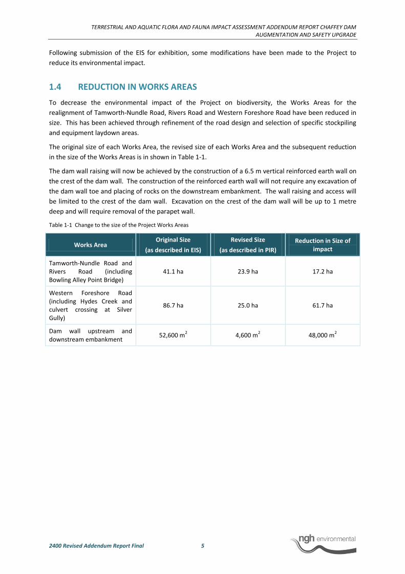
1.4 REDUCTION IN WORKS AREAS
To decrease the environmental impact of the Project on biodiversity, the Works Areas for the
realignment of Tamworth-Nundle Road, Rivers Road and Western Foreshore Road have been reduced in
size. This has been achieved through refinement of the road design and selection of specific stockpiling
and equipment laydown areas.
The original size of each Works Area, the revised size of each Works Area and the subsequent reduction
in the size of the Works Areas is in shown in Table 1-1.
The dam wall raising will now be achieved by the construction of a 6.5 m vertical reinforced earth wall on
the crest of the dam wall. The construction of the reinforced earth wall will not require any excavation of
the dam wall toe and placing of rocks on the downstream embankment. The wall raising and access will
be limited to the crest of the dam wall. Excavation on the crest of the dam wall will be up to 1 metre
deep and will require removal of the parapet wall.
Table 1-1 Change to the size of the Project Works Areas
Works Area Original Size
(as described in EIS)
Revised Size
(as described in PIR)
Reduction in Size of impact
Tamworth-Nundle Road and Rivers Road (including Bowling Alley Point Bridge)
41.1 ha 23.9 ha 17.2 ha
Western Foreshore Road (including Hydes Creek and culvert crossing at Silver Gully)
86.7 ha 25.0 ha 61.7 ha
Dam wall upstream and downstream embankment
52,600 m2 4,600 m
2 48,000 m
2
TERRESTRIAL AND AQUATIC FLORA AND FAUNA IMPACT ASSESSMENT ADDENDUM REPORT CHAFFEY DAM AUGMENTATION AND SAFETY UPGRADE
2400 Revised Addendum Report Final 6
Figure 1-1. Project layout
TERRESTRIAL AND AQUATIC FLORA AND FAUNA IMPACT ASSESSMENT ADDENDUM REPORT CHAFFEY DAM
AUGMENTATION AND SAFETY UPGRADE
2400 Revised Addendum Report Final 7
1.5 ASSESSMENT OF ALTERNATIVES
The Terrestrial and Aquatic Flora and Fauna Assessment (nghenvironmental 2012) assessed the
ecological impacts in relation to threatened species of the proposed safety upgrade and augmentation to
increase the dam capacity to 100 GL. Below is a comparison of ecological impacts under two alternative
scenarios; a lower capacity of 80 GL; and a higher capacity of 120 GL. A comprehensive comparison of
impacts of the alternative on vegetation communities is illustrated in Table 1-1.
As described in Section 2.1.9, augmentation of Chaffey Dam to 100 GL is expected to impact on
approximately 1.6 km of Booroolong Frog habitat. According to the channel width of the Peel River, this
equates to an area of approximately 4.77 ha.
In comparison to the proposed 100 GL capacity, an additional 600 m, or 0.87 ha of Booroolong Frog
habitat on the Peel River would be lost under the 120 GL capacity. Approximately 760 m, or 1.1 ha less of
Booroolong Frog habitat would be lost under the 80 GL capacity. Under all scenarios this would be
considered a significant loss of habitat. The National Recovery Plan for Booroolong Frog (NSW OEH
2012a) states that “habitat critical to the survival of the Booroolong Frog is rocky sections of permanent
streams occupied by the species. Any action that reduces stream permanency or results in loss of rock
crevices is likely to threaten the persistence of local populations of this species.”
Impacts to the Border Thick-tailed Gecko are not expected to differ between the different augmentation
scenarios. All scenarios would require construction works to the dam wall. Impacts associated with
construction will only occur on the crest of the dam wall during construction of the vertical wall, and
along the upstream face of the wall between the left bank and the morning glory spillway (a total of 2000
m2). Any loss of habitat on the upstream side of the dam wall through increased inundation would be
replaced through the increased dam wall height.
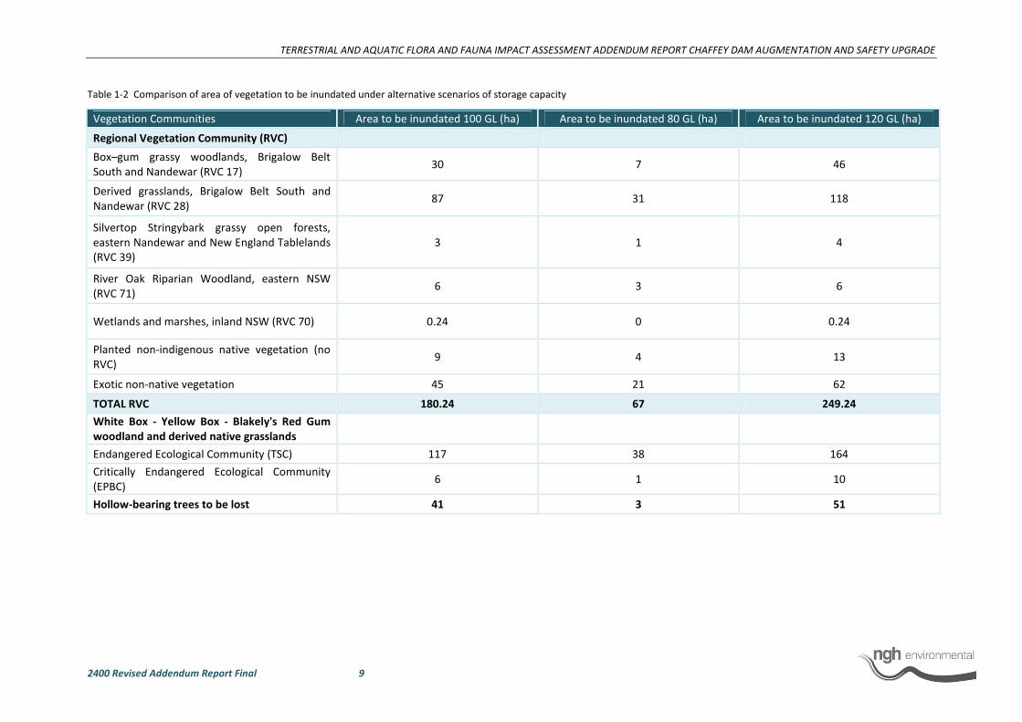
As described in the Terrestrial and Aquatic Flora and Fauna Assessment (nghenvironmental 2012) and
shown in Table 1-2, the proposed augmentation to 100 GL is expected to result in the inundation of
approximately 180 ha native and non-native vegetation. Comparatively, augmentation to 80 GL would
result in the inundation of 67 ha of vegetation (38 ha listed under the TSC and EPBC Acts), while
augmentation to 120 GL would result in the inundation of approximately 250 ha of vegetation (164 ha
listed under the TSC and EPBC Acts), including native and exotic non-native vegetation (Table 1-2).

TERRESTRIAL AND AQUATIC FLORA AND FAUNA IMPACT ASSESSMENT ADDENDUM REPORT CHAFFEY DAM
AUGMENTATION AND SAFETY UPGRADE
2400 Revised Addendum Report Final 8
Figure 1-2 Comparison of Full Supply Level under the three storage capacity scenarios of 80 GL, 100 GL and 120 GL.
°
0 0.5 10.25 Kilometres
1:40000
www.nghenvironmental.com.au
A4 @ Ref: 2400 - A3
Author: DM
100GL FSL (preferred option)
80GL FSL
120GL FSL
Notes:
- Base map sourced from ESRI Online © 2010
Microsoft Corporation and its data suppliers- Aerial photo provided by Worley Parsons May 2012
- 100GL FSL areas digitised by nghenvironmental based on
CAD layers supplied by Worley Parsons October 2012
- 80GL and 120GL CAD file supplied by Worely Parsons February 2013
TERRESTRIAL AND AQUATIC FLORA AND FAUNA IMPACT ASSESSMENT ADDENDUM REPORT CHAFFEY DAM AUGMENTATION AND SAFETY UPGRADE
2400 Revised Addendum Report Final 9
Table 1-2 Comparison of area of vegetation to be inundated under alternative scenarios of storage capacity
Vegetation Communities Area to be inundated 100 GL (ha) Area to be inundated 80 GL (ha) Area to be inundated 120 GL (ha)
Regional Vegetation Community (RVC)
Box–gum grassy woodlands, Brigalow Belt
South and Nandewar (RVC 17) 30 7 46
Derived grasslands, Brigalow Belt South and
Nandewar (RVC 28) 87 31 118
Silvertop Stringybark grassy open forests,
eastern Nandewar and New England Tablelands
(RVC 39)
3 1 4
River Oak Riparian Woodland, eastern NSW
(RVC 71) 6 3 6
Wetlands and marshes, inland NSW (RVC 70) 0.24 0 0.24
Planted non-indigenous native vegetation (no
RVC) 9 4 13
Exotic non-native vegetation 45 21 62
TOTAL RVC 180.24 67 249.24
White Box - Yellow Box - Blakely's Red Gum
woodland and derived native grasslands
Endangered Ecological Community (TSC) 117 38 164
Critically Endangered Ecological Community
(EPBC) 6 1 10
Hollow-bearing trees to be lost 41 3 51
TERRESTRIAL AND AQUATIC FLORA AND FAUNA IMPACT ASSESSMENT ADDENDUM REPORT CHAFFEY DAM
AUGMENTATION AND SAFETY UPGRADE
2400 Revised Addendum Report Final 10
2 SUBJECT SPECIES
2.1 BOOROOLONG FROG
Surveys conducted by nghenvironmental and North West Ecological Services (NWES) in January and
February 2013 were designed specifically to detect threatened species that were not detectable during
surveys carried out for the Project in 2012. Survey effort was guided by previous desktop investigations
and field surveys in areas of known or potential habitat.
Specifically, surveys for the Booroolong Frog were carried out by NWES during the species peak activity
period, both inside and outside the new FSL, as requested by Department of Planning and Infrastructure
(DP&I). Detailed survey data has been provided within this report.
2.1.1 Conservation Status
National
The Booroolong Frog is restricted to NSW and north-eastern Victoria tablelands and slopes from 200 m to
1300 m above sea level. The species is predominantly found along the western-flowing streams and their
headwaters of the Great Dividing Range, although a small number of animals have been recorded in
eastern-flowing streams (SEWPaC 2012; DECC 2005).
In early 1999, Booroolong Frogs were located along three small creeks, several kilometres north of the
Murray River, near Jingellic, southern NSW. A subsequent survey was undertaken, searching for the frogs
in four creeks (Burrowye, Walwa, Sandy, and Cudgewa Creeks) and the Murray River. Booroolong Frogs
were found on Burrowye Creek at Burrowye, and on the banks of the Murray River near Jingellic,
confirming the occurrence of the species in Victoria (The Victorian Frog Group 1999).
Within Victoria there are only two known locations for the Booroolong Frog in the north-east of the state;
Burrowye/Guys Forest Creek at Burrowye and Koetong Creek within Mount Lawson State National Park
(DSE 2013).
Overall, survey information indicates that the Booroolong Frog has undergone a severe decline and is no
longer present across more than 50% of the species' former range (NSW OEH 2012a). Since 1998,
surveys have been undertaken to determine the extent and cause of decline in the species.
The current geographic distribution of the Booroolong Frog extends from two streams near Tamworth in
northern NSW to the Southern Highlands in Victoria. The Booroolong Frog is known to occupy 30
separate locations, being a stream or group of streams which supports a population of Booroolong Frogs
connected by suitable habitat (Hunter 2013). An estimate of the area of occupancy for the Booroolong
Frog across its range is 520 km of stream across 56 streams. This estimate is based on targeted surveys
for this species, and extent of suitable habitat along occupied streams (Hunter 2013). Some areas of this
species historic known distribution on the New England Tablelands has not been the focus of targeted
surveys, therefore it is likely that this estimate of area of occupancy is an underestimate (Hunter 2013).
The most pronounced decline in the species' range has been across the Northern Tablelands where it was
once common but has not been located in recent years despite extensive fauna surveys undertaken by
the North-east Forest Biodiversity Study (NSW NPWS 1994), Regional Forests Assessment Program and
others (NSW NPWS 2004). Specific surveys in the Northern Tablelands for the Booroolong Frog
TERRESTRIAL AND AQUATIC FLORA AND FAUNA IMPACT ASSESSMENT ADDENDUM REPORT CHAFFEY DAM
AUGMENTATION AND SAFETY UPGRADE
2400 Revised Addendum Report Final 11
conducted in 1999 and 2000 failed to locate the species from a number of historic locations and other
potentially suitable habitat (Gillespie 2000).
Regional (NSW)
The Booroolong Frog has disappeared from the Northern Tablelands of NSW and is now rare throughout
most of the remainder of its range. Previously known populations within the Blue Mountains are no
longer able to be located.
The Booroolong Frog is now known from a single catchment in northern NSW - the Peel River catchment,
of which the Cockburn River is a sub-catchment (Anna Cronin pers comm. 2013).
The only records of the species in northern NSW outside the Northern Tablelands are from two streams
near Tamworth, NSW. These populations appear to be highly restricted and surveys of other previous
known localities and streams with potentially suitable habitat in the Tamworth-Murrurundi area failed to
locate additional populations of the Booroolong Frog (Gillespie 2000).
The Booroolong Frog was historically widespread throughout the Central Tablelands, having been
recorded from locations within and between tributaries of the Macquarie and Lachlan Rivers. Surveys
throughout this region have failed to locate the species along many of these streams, suggesting it is now
rare in the Central Tablelands region (Gillespie 1999; Gillespie 2000). The species persists in this region
along the Turon River and Winburndale Creek in the Winburndale Nature Reserve (NSW NPWS 2004) and
within the Abercrombie River Catchment (Gillespie 2000).
This report presents the most recent available survey data for the species in NSW.
Local (upper Peel River and Cockburn River within the Peel River Catchment).
Surveys by NWES (2009b) in 2008/2009 found the Booroolong Frog occurring in the headwater streams
of the Namoi Catchment between 400 to 700 metres above sea level. NWES located a large population
of this species upstream of Chaffey Dam on the Peel River (NWES 2009b). The population at that time
was conservatively estimated to be between 600 and 800 frogs (NWES 2009a). The area was again
surveyed in January and February 2013 by experienced herpetologists Phil Spark and Dr Andrew Stauber
and the species was found to be distributed along the Peel River from upstream of Chaffey Dam (within
the current FSL) to Pearly Gates Bridge, Wombramurra Creek, and further upstream on the Peel River
over a total distance of 25 km. The area surveyed and recorded locations of frogs are shown in Figure
2-3. A total of 2289 Booroolong frogs were recorded over 25 km of surveyed Peel River and
Wombramurra Creek. Note, there is still a section of the Peel River upstream of Pearly Gates Bridge that
has not been surveyed. However it is considered likely that the frogs would occur here (Phil Spark pers
comm. 2013).
A population of this size is presently unknown from anywhere else in the current distribution of the
species (P. Spark, pers. comm.).
2.1.2 Degree of Protection in Reserves
The majority of extant populations of the Booroolong Frog occur along streams that are not within nature
reserves and are continuing to be modified, primarily through cattle grazing and weed invasion, in a
manner that is likely to continue to contribute to the decline of this species. Habitat modification will
undoubtedly contribute to the continued decline of the Booroolong Frog in the short term and increase
TERRESTRIAL AND AQUATIC FLORA AND FAUNA IMPACT ASSESSMENT ADDENDUM REPORT CHAFFEY DAM
AUGMENTATION AND SAFETY UPGRADE
2400 Revised Addendum Report Final 12
the susceptibility of the species to other factors likely to be impacting on the species (for example the
disease chytridiomycosis and exotic fish).
2.1.3 Revised impact assessment
The large population of Booroolong Frogs approximately 1 km upstream of Chaffey Dam (634 individuals)
that was documented in NWES (2009b) had fallen to 50 individuals in the 2013 surveys at that location.
This supports the previous assertion of NWES (2009b) that such a large number of frogs at one location
was an anomaly and not representative of the distribution along the rest of the Peel River. Furthermore,
the summer 2013 surveys found that the Booroolong Frog was well distributed along the Peel River,
upstream of Chaffey Dam for a distance of approximately 25 km.
As discussed in nghenvironmental (2012), the high density of metamorph and juvenile Booroolong Frogs
found at the junction of the Peel River with Chaffey Dam in 2008/2009 may have been a result of two
floods that occurred in November and December 2008, washing eggs and possibly young tadpoles
downstream (NWES 2009b). The summer 2013 surveys support this hypothesis, as this site does not
currently support such a high abundance of individuals and the frog is well distributed upstream along
the Peel River. It is likely that after the floods individual Booroolong Frogs migrated from Chaffey Dam
upstream, and since that time there has been a spread in their distribution along the Peel River (Phil
Spark, pers. comm.). According to NWES (2009b) there is approximately 99 km of potential Booroolong
Frog habitat in the Namoi Catchment.
A very rough (and conservative) estimate of the Booroolong Frog population in the Namoi catchment was
made, based on the number of Booroolong Frogs recorded from the 66 x 500 metre survey transects over
99 km of stream. On average, three to four frogs were recorded per 500 m, equating to a total
population of between 594 and 792 frogs. This calculation excluded the 634 individuals recorded
immediately upstream of Chaffey Dam, because it was considered atypical. The calculation also assumes
that frogs occur along the length of the stream, which was not known at the time of writing (NWES
2009b).
Given the potential for 600 individual frogs to be impacted by inundation to the new FSL, the Terrestrial
and Aquatic Flora and Fauna Impact Assessment (nghenvironmental 2012) concluded that:
“the Project is likely to have a significant impact on the population of the endangered Booroolong Frog
that occurs immediately upstream of Chaffey Dam on the Peel River. However, this impact will be
localised and the impact to the species across its range is unlikely to be significant.”
It was recommended that surveys be undertaken in coordination with Namoi CMA during summer
2012/2013 to provide an updated estimate of the number of frogs both at the Chaffey Dam site and
further upstream on the Peel River, in order to more accurately assess potential impacts on the species.
2.1.4 Current Surveys
Targeted surveys for Booroolong Frogs and their habitat were undertaken by Phil Spark and Dr Andrew
Stauber over 21 nights between 17 January and 21 February 2013. These surveys comprised a follow-up
study for surveys undertaken in 2008/2009 by Phil Spark (NWES 2009b), and are therefore considered a
suitable comparison. The timing and methodology of these surveys were undertaken in accordance with
the Survey guidelines for Australia’s threatened frogs (DEWHA 2010), the Threatened species survey and
assessment guidelines: field survey methods for fauna (DECC 2009b) and the Hygiene Protocol for the
Control of Disease in Frogs (DECC 2008). The supplementary DGR’s requested that surveys be
TERRESTRIAL AND AQUATIC FLORA AND FAUNA IMPACT ASSESSMENT ADDENDUM REPORT CHAFFEY DAM
AUGMENTATION AND SAFETY UPGRADE
2400 Revised Addendum Report Final 13
undertaken during the breeding period (mid-November to mid-December), however the activity period
extends until February (as stated in DEWHA 2010) and is dependent on local climatic conditions. Phil
Spark conducted the surveys in January and February 2013 in response to local conditions and his
knowledge of the population. The commencement of surveys in January 2013 is not considered to be a
limitation due to the high activity levels observed during this period.
2.1.5 Methods
Night surveys were undertaken over the full width of the Peel River, commencing at the southern end of
Chaffey Dam and working upstream. Handheld spotlights were used to survey the ground along the
water’s edge, and under emerging rocks and logs. Booroolong Frogs were captured where necessary to
determine gender, and subsequently released.
A GPS location was recorded for each sighting, using Garmin hand-held units. For each individual, gender
or developmental status was recorded, along with microhabitat details. Notes were also taken on the
presence of other frog species, turtles and eastern water dragons.
2.1.6 Results
A distance of 21.3 km of the Peel River, immediately upstream of Chaffey Dam to Pearly Gates Bridge,
was sampled during the 2013 summer surveys. Two areas were also sampled further upstream; 0.5 km
of the Peel River approximately 11 km upstream of Pearly Gates Bridge, and 3.2 km of Wombramurra
Creek, a tributary of the Peel River approximately 8.8 km upstream of Pearly Gates Bridge (south) (Figure
2-3). Thus a total distance of approximately 25 km of the Peel River and one of its tributaries was
sampled in summer 2013. To date, 2289 Booroolong Frogs have been recorded over 21 nights of survey.
A total of 50 individuals were recorded over the 1.6 km of Peel River inside the new FSL (excluding four
individuals within a 200 m section of the existing FSL) and 2235 individuals along the Peel River and its
tributaries outside the new FSL.
Of the frogs recorded outside the new FSL, 2037 individuals were recorded over a 19.5 km stretch of the
Peel River upstream of the new FSL, 118 individuals were recorded within a 1.5 km stretch of
Wombramurra Creek, and a further 80 individuals were recorded within a 0.5 km stretch of the Peel River
further upstream. The majority of Booroolong Frogs were confined to stream sections where large rocks
were abundant.
This information is summarised in Table 2-1.
TERRESTRIAL AND AQUATIC FLORA AND FAUNA IMPACT ASSESSMENT ADDENDUM REPORT CHAFFEY DAM
AUGMENTATION AND SAFETY UPGRADE
2400 Revised Addendum Report Final 14
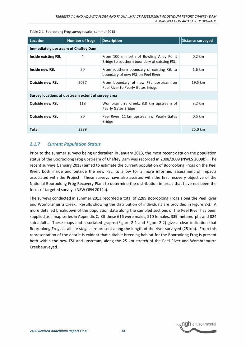
Table 2-1 Booroolong Frog survey results, summer 2013
Location Number of frogs Description Distance surveyed
Immediately upstream of Chaffey Dam
Inside existing FSL 4 From 100 m north of Bowling Alley Point
Bridge to southern boundary of existing FSL
0.2 km
Inside new FSL 50 From southern boundary of existing FSL to
boundary of new FSL on Peel River
1.6 km
Outside new FSL 2037 From boundary of new FSL upstream on
Peel River to Pearly Gates Bridge
19.5 km
Survey locations at upstream extent of survey area
Outside new FSL 118 Wombramurra Creek, 8.8 km upstream of
Pearly Gates Bridge
3.2 km
Outside new FSL 80 Peel River, 11 km upstream of Pearly Gates
Bridge
0.5 km
Total 2289 25.0 km
2.1.7 Current Population Status
Prior to the summer surveys being undertaken in January 2013, the most recent data on the population
status of the Booroolong Frog upstream of Chaffey Dam was recorded in 2008/2009 (NWES 2009b). The
recent surveys (January 2013) aimed to estimate the current population of Booroolong Frogs on the Peel
River, both inside and outside the new FSL, to allow for a more informed assessment of impacts
associated with the Project. These surveys have also assisted with the first recovery objective of the
National Booroolong Frog Recovery Plan; to determine the distribution in areas that have not been the
focus of targeted surveys (NSW OEH 2012a).
The surveys conducted in summer 2013 recorded a total of 2289 Booroolong Frogs along the Peel River
and Wombramurra Creek. Results showing the distribution of individuals are provided in Figure 2-3. A
more detailed breakdown of the population data along the sampled sections of the Peel River has been
supplied as a map series in Appendix C. Of these 616 were males, 510 females, 339 metamorphs and 824
sub-adults. These maps and associated graphs (Figure 2-1 and Figure 2-2) give a clear indication that
Booroolong Frogs at all life stages are present along the length of the river surveyed (25 km). From this
representation of the data it is evident that suitable breeding habitat for the Booroolong Frog is present
both within the new FSL and upstream, along the 25 km stretch of the Peel River and Wombramurra
Creek surveyed.

TERRESTRIAL AND AQUATIC FLORA AND FAUNA IMPACT ASSESSMENT ADDENDUM REPORT CHAFFEY DAM
AUGMENTATION AND SAFETY UPGRADE
2400 Revised Addendum Report Final 15
Figure 2-1 Sex and age class of Booroolong Frogs recorded in summer 2013 (NWES, 2013)
Figure 2-2 Booroolong Frog life stages from Chaffey Dam (Map 1) upstream (to Map 8) (NWES, 2013)
TERRESTRIAL AND AQUATIC FLORA AND FAUNA IMPACT ASSESSMENT ADDENDUM REPORT CHAFFEY DAM
AUGMENTATION AND SAFETY UPGRADE
2400 Revised Addendum Report Final 17
The summer 2013 surveys indicate that the Booroolong Frog population in the Peel River, immediately
upstream of Chaffey Dam, currently comprises in the order of 2000 individuals, with a broad distribution
along the length of the river surveyed (21.3 km). Fifty individuals were recorded within the new FSL,
representing approximately 2.2% of the current known population of the Peel River (excluding the four
individuals within the current FSL) surveyed in a 25 km stretch upstream of Chaffey Dam.
This suggests that the current impacts to the Booroolong Frog as a result of the Project are not as severe
as initially assessed based on surveys undertaken in 2008/2009. However, as the Booroolong Frog is
known to exhibit large fluctuations in abundance from one year to the next, as occurred when 634
individuals were observed within 1 km of Chaffey Dam, population abundance is not an accurate
indicator of population resilience (NSW OEH 2012a). Therefore a more accurate reflection of impact to
this species is to assess impact in relation to Booroolong Frog habitat.
2.1.8 Habitat
Surveys in summer 2013 found the Booroolong Frog to be well distributed along the Peel River, upstream
of Chaffey Dam. As discussed previously, the Booroolong Frog occupies a linear habitat, therefore area of
occupancy is best considered in terms of length of stream occupied (Hunter, 2013). These surveys
showed that the entire 25 km of Peel River and Wombramurra Creek surveyed was occupied by
Booroolong Frogs and is therefore considered to provide suitable habitat for the species. The presence of
metamorph and sub-adult (juvenile) life stages in the area surveyed confirms all 25 km is suitable
breeding habitat for the species (Figure 2-1, Figure 2-2 and Appendix C). The as yet unsurveyed section of
the Peel River as shown in Figure 2-3 is considered likely to be occupied by Booroolong Frogs (Phil Spark
pers. comm.).
The current data indicates that the Booroolong Frog is utilising the majority of habitat along the 25 km
stretch of the Peel River immediately upstream of Chaffey Dam. Furthermore, it is known that the
species uses a range of habitats at different life stages, with tadpoles developing in slow-flowing
connected or isolated pools (Anstis 2002). It is therefore evident that the Booroolong Frog has a reliance
on both riffle and pool habitats, which are the features that comprise the surveyed sections of the Peel
River.
The extent of shading along the Peel River was not taken into account during the summer 2013 surveys
by Phil Spark (NWES), however observations pertaining to depth and substrate were made at every
location where a Booroolong Frog was located. This gives an indication of preferred habitat by the
Booroolong Frog and indicates that the Booroolong Frog has a microhabitat preference for riffles with
large rocks (33%) followed by rapids with large rocks (26%) (Figure 2-4). Detailed maps showing the
distribution of the Booroolong Frog population on the Peel River, upstream of Chaffey Dam is provided in
Appendix C. It is clear from these maps that Booroolong Frogs are well distributed upstream of Chaffey
Dam, as are the habitat features utilised by the species at each of those locations. This is further
supported by the graph in Figure 2-4 which portrays the proportion of each habitat type within each of
the maps (stream sections surveyed). Overall, the most common habitat components across the entire
area surveyed (25 km) were rapid or riffle zones with large rocks. Booroolong Frogs, both adults and
juveniles, were also found in areas described as ‘hole, still – gravel bank’. It is also evident that the
species is less reliant on areas with small rocks. Furthermore, there were very few (if any) individuals
found in areas of ‘hole, still – dirt bank’, otherwise known as the edges of deep pools. Nonetheless, the
trend in habitat preferences is very similar across the 25 km surveyed in summer 2013. From the maps
provided in Appendix C it is evident that there is no gap in Booroolong Frog occupation along the Peel
River greater than 200 m (with most gaps much less than this). Therefore, it seems reasonable to assume

TERRESTRIAL AND AQUATIC FLORA AND FAUNA IMPACT ASSESSMENT ADDENDUM REPORT CHAFFEY DAM
AUGMENTATION AND SAFETY UPGRADE
2400 Revised Addendum Report Final 18
that the ratio of suitable versus unsuitable habitat is relatively even. As a mobile species, the Booroolong
Frog is likely to range outside of the locations identified by Phil Spark in summer 2012/2013. As such, we
have assumed that the entire length of river both within the new FSL and outside the new FSL provided a
similar proportion of suitable habitat for the Booroolong Frog.
Figure 2-4 Microhabitat selection by Booroolong Frogs surveyed in summer 2013 in the Peel River and Wombramurra
Creek, from Chaffey Dam (Map 1) upstream (to Map 8) (source NWES 2013).
In the 2012 Terrestrial and Aquatic Flora and Fauna Impact Assessment (nghenvironmental 2012), riffle
habitats were assessed as optimal Booroolong Frog habitat both within the new FSL and outside of the
new FSL. Given the outcomes of the summer 2013 surveys, the loss of habitat as a result of inundation to
the new FSL has been re-assessed to include the entire length of the river between the existing FSL and
the new FSL for a distance of 1.6 km. The Peel River is a dynamic system; areas of suitable Booroolong
Frog habitat will change in response to rainfall or lack thereof. Therefore, the total river channel width
(calculated using ArcGIS) has been used to calculate the area of Booroolong Frog habitat within the 1.6
km stretch of stream to be impacted by the Project. This method gives an area of 4.77 ha of Booroolong
Frog habitat on the Peel River that will be impacted as a result of inundation. This calculation of area has
been used in order to utilise the BioBanking Credit Calculator and the EPBC Offsets Calculator. However,
as the Booroolong Frog occupies a linear habitat, area of occupancy is best considered in terms of length
of stream occupied (Hunter, 2013). The length of 1.6 km equates to approximately 6.4% of the known
Booroolong Frog habitat on the Peel River. This is a conservative estimate. The impact of 6.4% is
calculated according to the area of stream over which Booroolong Frogs were recorded during the
summer 2013 surveys. There is a high probability that Booroolong Frogs would also occupy the 15 km
section not surveyed between Pearly Gates Bridge and Wombramurra Creek, and further upstream along
the Peel River (Phil Spark, pers. comm.) (Figure 2-3). The presence of Booroolong Frogs at the upstream
and downstream extent of the survey area, strongly suggests they would also be present in the un-
surveyed section. This would mean a total occupied area of more than 40 km and an impact area
TERRESTRIAL AND AQUATIC FLORA AND FAUNA IMPACT ASSESSMENT ADDENDUM REPORT CHAFFEY DAM
AUGMENTATION AND SAFETY UPGRADE
2400 Revised Addendum Report Final 19
therefore of less than 4%. However, with the aim of quantifying the impact of the Project on known
Booroolong Frog habitat as opposed to potential habitat, a conservative calculation of 6.4% has been
provided (not 4%).
2.1.9 Potential Impacts
It is estimated that the area of Booroolong Frog habitat to be impacted by inundation to the new FSL is
4.77 ha. This is based on the actual channel width of the Peel River within the distance between the
existing FSL and the new FSL (1.6 km), and has been calculated using ArcGIS. Fifty Booroolong Frogs were
recorded within this area during surveys in summer 2013. Suitable breeding habitat for the Booroolong
Frog is present along the 25 km stretch of the Peel River and Wombramurra Creek surveyed. The loss of
habitat within the impact site (1.6 km) will not remove important breeding habitat over and above
breeding habitat present upstream of the new FSL.
Based on simulated 100 year dam volumes, the minimum duration over which the additional inundation
will occur is expected to be between eight and 21 weeks, although inundation to the new FSL could take
up to several years. Thus the magnitude of the impact on the individuals recorded within the FSL will
initially be low and gradual. Given the proven ability of the frogs to move according to changed
conditions evidenced by the four individuals recorded within the existing FSL, this may mitigate (slow) the
rate of habitat loss and provide an opportunity for the natural migration of individuals upstream, thereby
reducing the impact to the species.
Water levels in the reservoir fluctuate with corresponding rainfall, inflow and drought events. Following
implementation of the Project, the reservoir water level will not always be at the new FSL. According to
simulated 100 year dam volumes, following augmentation to 100 GL the reservoir will only be at FSL 24%
of the time. Further, the reservoir will be at or below the existing FSL around 21% of the time.
The changes in the reservoir storage level means that 100% of the 1.6 km of Booroolong Frog habitat is
only inundated when the reservoir is at 100% capacity (i.e. 24% of the time). While the suitability of
habitat for the frogs once it has been inundated and the water level has dropped is unknown, for all
storage levels below 100% the impact is less, to the point where the storage reduces to the existing FSL
(or below) and the impact is zero.
The distribution of Booroolong Frog along the Peel River recorded in the summer 2013 surveys compared
to the recorded distribution and abundance in 2009 (NWES 2009b) suggests that the Booroolong Frog is
capable of migrating upstream and downstream and is resilient to a wetting and drying cycle. Thus,
habitat currently occupied by the Booroolong Frog inside the new FSL may intermittently provide habitat
for the Booroolong Frog following implementation of the Project, when reservoir levels are below the
new FSL.
Due to uncertainties regarding the timing of initial inundation and the quality of the habitat post-
inundation, the permanent loss of habitat inside the new FSL has been assessed. The National Recovery
Plan for the Booroolong Frog states that “any action that reduces stream permanency or results in loss of
rock crevices, is likely to threaten the persistence of local populations of this species”. Therefore, despite
the current abundance of the Booroolong Frog along the Peel River, the loss of 1.6 km (6.4%) of known
Booroolong Frog habitat is considered to have a significant impact at a local and regional level. This
population immediately upstream of Chaffey Dam forms the largest and most continuous distribution of
the species known in northern NSW, and potentially Australia. As such, an Offset Plan has been prepared
to satisfy the legislative requirements with the aim of reducing known threatening processes occurring
TERRESTRIAL AND AQUATIC FLORA AND FAUNA IMPACT ASSESSMENT ADDENDUM REPORT CHAFFEY DAM
AUGMENTATION AND SAFETY UPGRADE
2400 Revised Addendum Report Final 20
along the Peel River, thereby contributing to the recovery of the Booroolong Frog in the Namoi
catchment (Appendix D).
An Assessment of Significance in accordance with the EPBC Act Significant Impact Guidelines 1.1 Matters
of National Environmental Significance is provided in Appendix A.3.
2.1.10 Management measures for Booroolong Frog
Due to the nature of the Project, impacts to the Booroolong Frog through inundation to the new FSL are
unavoidable and cannot be mitigated. Accordingly, management measures are outlined below.
Major factors contributing to the decline of the Booroolong Frog within the Namoi catchment include
disease (Chytridiomycosis) and habitat degradation (e.g. erosion due to vegetation clearing, stock grazing,
and fossicking; weed invasion; sedimentation) (NSW OEH 2012a). As such, recommendations and
management measures for the Booroolong Frog have been proposed in order to respond to these factors
and contribute to the recovery of this species along the Peel River.
The following mitigation measures will be incorporated into the Project to limit impacts to the
Booroolong Frog during construction:
• Strict hygiene protocols (Weeks 1 to 104)
• Sediment and erosion controls (Weeks 1 to 104)
• An ecologist will be engaged to prepare induction material to outline the species profile,
hygiene protocols and maps of sensitive areas in relation to the Booroolong Frog.
Induction of all contractors will be carried out at the commencement of onsite activities
specifically at Bowling Alley Point Bridge. Additional inductions will be carried out
periodically as new contractors enter the site. (Weeks 13 to 60 where appropriate)
As part of these management measures an Offset Plan which will strive to “improve or maintain” the
existing population has been proposed and is included in Appendix D.
• A management plan will be developed and implemented for the Booroolong Frog that will
include provision for:
o Remediation and threat mitigation as required at offset sites (e.g. stock exclusion,
weed removal, removal of exotic shading vegetation, protection from fossicking).
o Post-construction monitoring for a minimum of two years to monitor the success
of remediation and threat mitigation measures outside of the FSL, and to monitor
the impacts of inundation on Booroolong Frog populations located within the FSL.
This will be dependent on the rate of inundation and consultation with the
relevant parties (e.g. Namoi CMA). Annual auditing and reporting would be
required in order to detect potential problems associated with implementing
mitigation measures (e.g. landholder compliance) as well as annual monitoring
during the summer breeding season to assess the success of those measures and
response of the Booroolong Frog population.
o Following further consideration of mitigation strategies and consultation with
OEH and Namoi CMA, relocation is no longer proposed for the Booroolong Frog.
o Any monitoring undertaken must comply with the Hygiene Protocol for the
Control of Disease in Frogs (DECC 2008) in order to prevent the spread of
Chytridiomycosis.
• Riparian restoration and protection program. This will include:
TERRESTRIAL AND AQUATIC FLORA AND FAUNA IMPACT ASSESSMENT ADDENDUM REPORT CHAFFEY DAM
AUGMENTATION AND SAFETY UPGRADE
2400 Revised Addendum Report Final 21
o Rehabilitation of the riparian zone to promote regeneration of native riparian
vegetation
o Weed control with a focus on woody weeds such as willows and Blackberry.
o Signage to reduce human access.
These management measures have been designed in consultation with OEH, Namoi CMA and relevant
experts. These management plans will form part of the approved Offset Management Plan.
2.1.11 Expected or Predicted Effectiveness of proposed mitigation
Threats to the Booroolong Frog are relatively well known and documented. Primary threats include
disturbance and siltation impacts from fossicking and stock trampling, weed infestation, shading from
exotic vegetation, chytrid, predation on adults frogs by foxes and predation on tadpoles by exotic fish
such as European Carp.
The Offset Plan and management measures therein aim to address as many of these threats as possible
by implementing private conservation agreements with landholders that ensure the management of
riparian habitats along the Peel River with the aim of reducing the operation of these threats. The details
of the implementation, timing, duration and nature of management activities will be finalised in
consultation with Namoi CMA, OEH, SEWPaC and other relevant species experts.
2.2 QUEENSLAND BLUEGRASS
An historical record exists for Queensland Bluegrass in the Bowling Alley Point cemetery from early
February 2003 (Appendix A). The cemetery is located in close proximity (approximately 500m east) to the
Chaffey Dam reservoir and the habitat that occurs within the cemetery is similar to that which occurs
within the area to be inundated by the proposed augmentation.
Targeted surveys carried out by nghenvironmental in October 2012 did not locate Queensland Bluegrass
at the location of the previous recording or elsewhere in the study area. However, as the species is more
likely to be flowering (and thus identifiable) in summer, it was determined that summer surveys were
necessary to determine whether it is present or absent in the study area. Without these surveys the
employment of the precautionary principle assumed that there was the potential for a significant impact
to Queensland Bluegrass as a result of the Project. It was estimated that approximately 10 ha of high
quality box gum woodland providing suitable habitat for Queensland Bluegrass, would be impacted by
the Project as a result of both inundation and construction (nghenvironmental 2012).
2.2.1 Survey Methods
A targeted summer survey for Queensland Bluegrass was undertaken from the 31 January to 1 February
2013 by two experienced botanists. This survey timing was considered suitable for detecting the species
as the survey was carried out in the known flowering period for the species (NSW OEH 2012b) and the
previous record was recorded on the 10 February 2003. A total of 13 person hours was dedicated to
Queensland Bluegrass surveys (Table 2-2). The timing and effort devoted to this survey is considered to
be adequate to confidently assess the presence or absence of this species.
Foot based surveys were conducted employing parallel transects spaced approximately 5 m to 10 m apart
through areas of suitable habitat. A total of five foot based transect surveys were conducted, one at the
location of the previous record (outside of the area of impact) and four within the area to be impacted by

TERRESTRIAL AND AQUATIC FLORA AND FAUNA IMPACT ASSESSMENT ADDENDUM REPORT CHAFFEY DAM
AUGMENTATION AND SAFETY UPGRADE
2400 Revised Addendum Report Final 22
the Project, focusing on areas of better quality habitat. Areas immediately adjacent to the area to be
impacted where also included.
A single driving transect was also conducted through lower quality habitat while moving between foot
based survey locations. This consisted of observing from both sides of a slow moving vehicle, stopping
when required to confirm species identifications.
The locations of transects and associated survey effort are described in Table 2-2. A map of survey effort
is presented in Figure 2-5.
Table 2-2 Queensland Bluegrass targeted survey locations and effort
Transect
No.
Targeted survey location description Survey effort
(person hours)
1 Bowling Alley Point cemetery 2.0
2 Box-Gum Woodland, eastern foreshore, north of Bowling Alley Point
Recreation Area
3.5
3 Box-Gum Woodland derived grassland, eastern foreshore, between transect 2
and 4 (driving)
1.0
4 Box-Gum Woodland, eastern foreshore, opposite access road to cemetery 3.0
5 Box-Gum Woodland, eastern foreshore, north of Bowling Alley Point Bridge 2.0
6 Box-Gum Woodland derived grassland along northern verge of the Tamworth –
Nundle Road within proposed road works area
1.5
Total 13.0

TERRESTRIAL AND AQUATIC FLORA AND FAUNA IMPACT ASSESSMENT ADDENDUM REPORT CHAFFEY DAM
AUGMENTATION AND SAFETY UPGRADE
2400 Revised Addendum Report Final 23
Figure 2-5 Queensland Bluegrass targeted survey locations
[�
4
3
2
5
1
6
°
0 200 400100 Meters
1:20000
www.nghenvironmental.com.au
A4 @
Ref: 2400 - 1
Author: DM
Notes:
- Field data collected by nghenvironmental field staff
(31 January and 1 February 2013 )- Base map sourced from ESRI Online © 2010 Microsoft Corporation and its data suppliers
- Aerial photo provided by Worley Parsons May 2012- Study area digitised by nghenvironmental based on
CAD layers supplied by Worley Parsons October 2012
Study area
[� Previous record
Targeted transect surveys
Foot
Vehicle
TERRESTRIAL AND AQUATIC FLORA AND FAUNA IMPACT ASSESSMENT ADDENDUM REPORT CHAFFEY DAM
AUGMENTATION AND SAFETY UPGRADE
2400 Revised Addendum Report Final 24
2.2.2 Results
From the six transect surveys conducted, no Queensland Bluegrass individuals were identified and it is
considered unlikely that any would have been overlooked. Despite extensive searches, the previous
record of this species within the Bowling Alley Point cemetery was not detected and thus not able to be
verified.
The more common species of Bluegrass (Dichanthium sericeum), which is not listed as threatened under
Commonwealth or State legislation, was identified along all transects within the areas to be impacted
(being particularly abundant at transect 4) however, it was not detected within the cemetery.
Considering that species of Dichanthium are generally shade intolerant it is possible that the overstorey
within the cemetery has developed to the extent as to render the habitat unsuitable for either D.
sericeum or D. setosum and that the threatened species no longer persists at this location.
2.2.3 Potential impacts and mitigation
The Terrestrial and Aquatic Flora and Fauna Impact Assessment conducted by nghenvironmental in 2012
concluded that due to a previous record of the species (from 2003) in close proximity to the study area
and that similar habitat occurred within the area to be impacted, a population of Queensland Bluegrass
could exist and be impacted by the Project. As such, further surveys were recommended during the peak
flowering period of Queensland Bluegrass in order to detect the species if it occurs, and accurately assess
the impact of the Project on Queensland Bluegrass.
Targeted searches conducted on the 31 January and 1 February 2013 did not detect Queensland
Bluegrass, either at Bowling Alley Point cemetery where it had previously been recorded, or in optimal
habitat within the study area.
Given the suitability of the timing of the surveys and that all areas of better quality habitat within the
area to be impacted were searched and the species not detected, it is considered that the species does
not occur on the site and will not be impacted by the Project. No further recommendations are
considered to be required for this species.
2.3 BORDER THICK-TAILED GECKO
The Border Thick-tailed Gecko is listed as vulnerable under the TSC Act and the EPBC Act. This species is
patchily distributed on the tablelands and slopes of northern NSW and southern Queensland, reaching
south to Tamworth and west to Moree (NSW OEH 2012c). It is most common in the granite country of
the New England Tablelands, occurring at sites ranging from 500 to 1100 m elevation. Populations are
mostly fragmented, with over 50 discrete sites currently known that are separated by at least 2 km (NSW
OEH 2012c).
There are 11 records in six locations of the Border Thick-tailed Gecko within 10 km of the dam wall, from
between 1993 and 2008 (Appendix A). Most recently, this species has been recorded on the dam wall
and in the remnant vegetation of Goat Mountain, adjacent to the dam wall (NWES 2009a and
nghenvironmental 2012).
The artificial rocky surface area of the downstream dam wall currently provides approximately 50,000 m2
of Border Thick-tailed Gecko habitat. The upstream face of the dam wall above the existing FSL provides
an additional 6,000 m2 of suitable rocky habitat (of which 2,600 m
2 will be impacted by inundation). A
change to the scope of works since submission of the PIR means that the total area of Border Thick-tailed
Gecko habitat on the downstream face of the wall (50,000 m2) will no longer be impacted by

TERRESTRIAL AND AQUATIC FLORA AND FAUNA IMPACT ASSESSMENT ADDENDUM REPORT CHAFFEY DAM
AUGMENTATION AND SAFETY UPGRADE
2400 Revised Addendum Report Final 25
construction. Impacts associated with the revised construction methodology will occur along the
upstream face of the wall between the left bank and the morning glory spillway. This constitutes a total
impact area of 2,000 m2 during construction and 2,600 m
2 from inundation (a total of 4,600 m
2). Given
the substantial reduction in the area of impact on the dam wall, significant impacts to the gecko during
construction have been avoided.
Surveys carried out by nghenvironmental in October 2012, in a total survey effort time of 240 person
minutes, confirmed the presence of the Border Thick-tailed Gecko on the dam wall and on Goat
Mountain to the immediate north of the dam (nghenvironmental 2012). The recommended survey
period is November to February (SEWPaC 2011), however confirmation of the species presence on the
dam wall was achieved in October, therefore no further surveys were considered to be required.
The proposed mitigation measures set out in Section 4 aim to avoid impacts to the Border Thick-tailed
Geckos that occur within the impact zone during construction on the dam wall.
2.3.1 Habitat and Population at Chaffey Dam
Artificial habitat for the Border Thick-tailed Gecko is provided by the large rocks that form the existing
dam wall. In 2008 and 2009 NWES conducted targeted searches for the Border Thick-tailed Gecko, and
found it to be relatively common on the dam wall, as well as in shrubby rocky remnants around
Woolomin, including Goat Mountain, to the immediate northwest of the dam wall.
The Border Thick-tailed Gecko was observed by NWES in 2008 on the dam wall (NWES 2009a). The
species was also found to be relatively common within the locality and the region, recorded many times
in shrubby rocky remnants around Woolomin, including Goat Mountain, to the immediate northwest of
the dam wall. Geckos were also found to be relatively common within woodland remnants, dry open
forests with a patchy and continuous shrub layer (NWES 2009a). NWES (2009a) concluded that the
geckos on the dam wall are likely to be part of a much larger population in the remnant habitat of Goat
Mountain.
One individual was found on Goat Mountain during surveys by nghenvironmental in October 2012. A
further three individuals were found on the top of the downstream face of the dam wall in October 2012.
However, due to access and safety issues, it was not possible to survey the whole of the artificial rock pile
of the dam wall.
Construction associated with the raising of the dam wall has been designed to avoid impacts to the
Border Thick-tailed Gecko. Provided that the proposed mitigation measures are carried out, the Project is
not considered to have an impact on this species at a local, regional or national scale. No natural habitat
for the species will be removed. An offset is not required for this species in accordance with the EPBC Act
Environmental Offsets Policy and the NSW BioBanking Assessment Methodology, however habitat on
Goat Mountain where the Border Thick-tailed Gecko is present will be offset as part of the proposed
Offset Plan (Appendix D).
2.3.2 Potential Impacts
Surveys by nghenvironmental in October 2012 confirmed the presence of the Border Thick-tailed Gecko
on the dam wall (three individuals). The Gecko is known to currently inhabit the dam wall but due to the
access and safety issues in surveying such a habitat the number of individuals is unknown.
Due to a change in the Project methodology, there has been a substantial reduction in the level of impact
to the Border Thick-tailed Geckos inhabiting the dam wall. The raising of the morning glory spillway

TERRESTRIAL AND AQUATIC FLORA AND FAUNA IMPACT ASSESSMENT ADDENDUM REPORT CHAFFEY DAM
AUGMENTATION AND SAFETY UPGRADE
2400 Revised Addendum Report Final 26
access bridge and platform on the piers, and changes to the auxiliary spillway and fuse plug will no longer
proceed as part of the proposed works. Raising of the dam wall by placement of rock on the downstream
face is no longer required. As an alternative, a vertical reinforced earth embankment for wall raising will
be constructed on the crest of the dam wall (Figure 2-6). As a result, the 50,000 m2 of Border Thick-tailed
Gecko habitat on the downstream face of the wall will no longer be impacted. Impacts to Border Thick-
tailed Gecko habitat associated with the revised construction methodology will only occur along the
upstream face of the wall between the left bank and the morning glory spillway. This constitutes an
impact area of 2,000 m2as a result of construction. As such, relocation of geckos to an area of artificial
habitat will no longer be required. Revised mitigation and management measures are detailed below.
Figure 2-6 Revised construction methodology on the Chaffey Dam wall
Overall, it has been estimated that approximately 4,600 m2
of the upstream dam wall habitat will be
impacted by both inundation (2,600 m2) and construction (2,000 m
2). The remaining 1,400m
2 on the
upstream face of the wall will continue to provide suitable habitat for the Border Thick-tailed Gecko
throughout the construction phase. The 50,000 m2
of Border Thick-tailed Gecko habitat on the
downstream face of the dam wall will not be impacted by the Project and will continue to provide the
species with suitable habitat during and post-construction. Post-construction, the Border Thick-tailed
Gecko will have access to the entire upstream and downstream face of the dam wall. There will be no
operational phase impacts on the species.
No other Border Thick-tailed Gecko habitat will be impacted as a result of the Project. Mitigation
measures have been designed to avoid impacts to Border Thick-tailed Gecko individuals inhabiting the
works areas on the dam wall throughout the construction process, and are detailed in Section 2.3.3.
The Gecko occurs naturally on Goat Mountain to the immediate north of the dam wall and this
population will not be impacted by the Project. Given it’s occurrence in surrounding areas and that only
a small proportion (8.7%) of artificial habitat will be impacted by the Project, it is likely that the species
will recolonise the works areas on the dam wall post-construction, therefore the impact is unlikely to be
significant.
No naturally occurring population of the species will be impacted by the Project. Furthermore the
proposed offset location northwest of the dam encompasses Goat Mountain which supports a known
population of the species. There will be no translocation of individuals from the dam wall into already
occupied habitats.
An Assessment of Significance in accordance with the EPBC Act Significant Impact Guidelines 1.1 Matters
of National Environmental Significance is provided in Appendix A.3.
TERRESTRIAL AND AQUATIC FLORA AND FAUNA IMPACT ASSESSMENT ADDENDUM REPORT CHAFFEY DAM
AUGMENTATION AND SAFETY UPGRADE
2400 Revised Addendum Report Final 27
2.3.3 Mitigation and management measures for the Border Thick-tailed Gecko
To avoid impacts to the Border Thick-tailed Gecko during the construction phase, works will follow a
staged and strategic plan for the clearing and excavation. The entire wall will not be impacted, therefore
the geckos will be able to continue to utilise areas of the wall during construction. A Fauna Management
Plan will be prepared and implemented to guide the construction phase activities including the following
considerations:
• Disturbance to any area of Border Thick-tailed Gecko habitat on the dam wall will only
take place between the months of September and April.
• Three nights of pre-clearing surveys will be undertaken prior to construction to relocate
individuals from the crest of the dam wall to adjacent areas of the wall which will not be
impacted.
• A Fauna Management Plan will be prepared and implemented to guide the construction
phase activities including the following considerations:
o A Construction Environmental Management Plan (EMP) will provide employees
on the construction site with detailed information on the Border Thick-tailed
Gecko relating to its identification, habitat preferences, time of activity, and the
appropriate procedures upon encountering individuals.
o An ecologist will be on site during construction to ensure the safe relocation of all
fauna species encountered, to other areas of the wall not to be impacted by
construction.
o If many (>5) individuals are encountered during construction, activities will stop,
and an additional night survey will be conducted in order to relocate individuals
to adjacent areas of the wall that will not be impacted by construction.
Construction may recommence.
The wildlife corridor created in late 2011 and early 2012 linking Goat Mountain with the Peel River and
habitat areas to the east was designed as a movement corridor for fauna, but is currently adversely
impacted by stock and weeds.
• Weed management would be ongoing as per the Vegetation Management Plan particularly
focusing on Coolatai Grass infested areas around the dam wall and planted wildlife corridor.
Coolatai grass has been identified as a key threatening process for the Border Thick-tailed Gecko.
2.3.4 Expected or Predicted Effectiveness of proposed mitigation
Due to significant changes in the proposed construction methodology on the dam wall, impacts to the
Border Thick-tailed Gecko have been substantially reduced. The Project will now only affect
approximately 4,600 m2 of Border Thick-tailed Gecko artificial habitat as a result of inundation and
construction, as opposed to the 52,600 m2 originally assessed (nghenvironmental 2012;
nghenvironmental 2013). While the majority of works have avoided known habitat for the species,
adverse impacts on individuals within the revised impact area will be avoided through the mitigation
measures proposed.
The mitigation measures proposed for the Border thick-tailed Gecko have been developed in consultation
with State Water and OEH to provide certainty of practicality and acceptability. Assumptions have been
based on available data on the distribution of the species locally, elsewhere in the study area and within
the artificial habitat of the dam wall. Adverse impact on the species will be avoided through the staged
approach to construction that State Water has committed to.
TERRESTRIAL AND AQUATIC FLORA AND FAUNA IMPACT ASSESSMENT ADDENDUM REPORT CHAFFEY DAM
AUGMENTATION AND SAFETY UPGRADE
2400 Revised Addendum Report Final 28
2.4 MURRAY COD
2.4.1 Populations and Habitat
The Murray Cod occurs in a range of flowing and standing waters, from small, clear, rocky streams on the
inland slopes and uplands of the Great Diving Range, to the large, turbid, meandering slow-flowing rivers,
creeks, anabranches, and lakes and larger billabongs, of the inland plains of the Murray Darling Basin.
Within these broad habitat types, Murray Cod are usually found associated with complex structural cover
such as large rocks, large snags and smaller structural woody habitat, undercut banks and over-hanging
vegetation (Dakin and Kesteven 1938; Lake 1967b; Langtry in Cadwallader 1977; Cadwallader 1979;
Cadwallader and Backhouse 1983; Harris and Rowland 1996; Koehn 1996, 2006; Rowland 1988a, 2005).
The length of the Peel River and Chaffey Dam provides habitat for this species. Habitat critical for the
species has not been identified in the National Recovery Plan for the Murray Cod (National Murray Cod
Recovery Team 2010) or the Register of Critical Habitat maintained by the minister under the EPBC Act.
Figure 2-7 maps the known records of Murray Cod within Chaffey Dam and the Peel River, habitat for the
Murray Cod and indicates the extent of the potential downstream and upstream impacts. Known records
were sourced data provided by DPI (fisheries) on 30 April 2013. Minor watercourses indicated on Figure
2-7, tributaries to the Peel River, are also potential habitat for the species.
A search of the Atlas of Living Australia and the NSW Bionet Atlas on 2 May 2013 did not identify any
previous records of the Murray Cod in Chaffey Dam or along the Peel River.
It should be noted that known records do not provide an accurate indication of the prevalence of the
species within the Peel River and Chaffey Dam. As discussed below, Peel River and Chaffey dam are an
important recreational fishing area and the Murray Cod is regularly stocked within these areas (Table
2-3).

TERRESTRIAL AND AQUATIC FLORA AND FAUNA IMPACT ASSESSMENT ADDENDUM REPORT CHAFFEY DAM
AUGMENTATION AND SAFETY UPGRADE
2400 Revised Addendum Report Final 29
Figure 2-7 Location of previous Murray Cod records, extent of downstream and upstream impacts and habitat of Murray
Cod
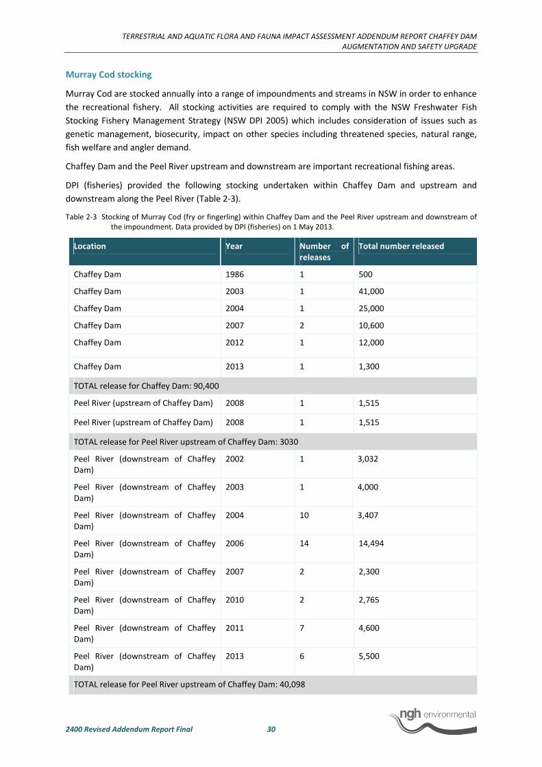
TERRESTRIAL AND AQUATIC FLORA AND FAUNA IMPACT ASSESSMENT ADDENDUM REPORT CHAFFEY DAM
AUGMENTATION AND SAFETY UPGRADE
2400 Revised Addendum Report Final 30
Murray Cod stocking
Murray Cod are stocked annually into a range of impoundments and streams in NSW in order to enhance
the recreational fishery. All stocking activities are required to comply with the NSW Freshwater Fish
Stocking Fishery Management Strategy (NSW DPI 2005) which includes consideration of issues such as
genetic management, biosecurity, impact on other species including threatened species, natural range,
fish welfare and angler demand.
Chaffey Dam and the Peel River upstream and downstream are important recreational fishing areas.
DPI (fisheries) provided the following stocking undertaken within Chaffey Dam and upstream and
downstream along the Peel River (Table 2-3).
Table 2-3 Stocking of Murray Cod (fry or fingerling) within Chaffey Dam and the Peel River upstream and downstream of
the impoundment. Data provided by DPI (fisheries) on 1 May 2013.
Location Year Number of
releases
Total number released
Chaffey Dam 1986 1 500
Chaffey Dam 2003 1 41,000
Chaffey Dam 2004 1 25,000
Chaffey Dam 2007 2 10,600
Chaffey Dam 2012 1 12,000
Chaffey Dam 2013 1 1,300
TOTAL release for Chaffey Dam: 90,400
Peel River (upstream of Chaffey Dam) 2008 1 1,515
Peel River (upstream of Chaffey Dam) 2008 1 1,515
TOTAL release for Peel River upstream of Chaffey Dam: 3030
Peel River (downstream of Chaffey
Dam)
2002 1 3,032
Peel River (downstream of Chaffey
Dam)
2003 1 4,000
Peel River (downstream of Chaffey
Dam)
2004 10 3,407
Peel River (downstream of Chaffey
Dam)
2006 14 14,494
Peel River (downstream of Chaffey
Dam)
2007 2 2,300
Peel River (downstream of Chaffey
Dam)
2010 2 2,765
Peel River (downstream of Chaffey
Dam)
2011 7 4,600
Peel River (downstream of Chaffey
Dam)
2013 6 5,500
TOTAL release for Peel River upstream of Chaffey Dam: 40,098
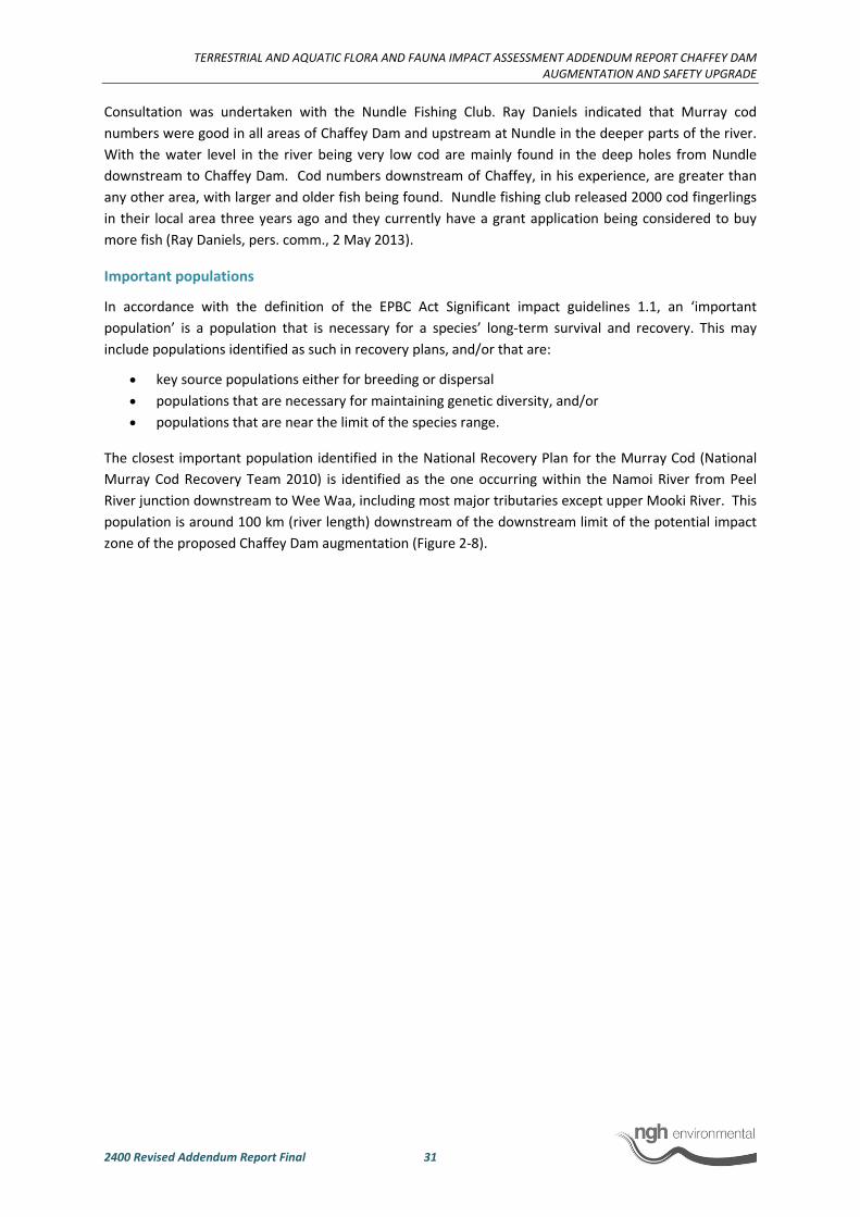
TERRESTRIAL AND AQUATIC FLORA AND FAUNA IMPACT ASSESSMENT ADDENDUM REPORT CHAFFEY DAM
AUGMENTATION AND SAFETY UPGRADE
2400 Revised Addendum Report Final 31
Consultation was undertaken with the Nundle Fishing Club. Ray Daniels indicated that Murray cod
numbers were good in all areas of Chaffey Dam and upstream at Nundle in the deeper parts of the river.
With the water level in the river being very low cod are mainly found in the deep holes from Nundle
downstream to Chaffey Dam. Cod numbers downstream of Chaffey, in his experience, are greater than
any other area, with larger and older fish being found. Nundle fishing club released 2000 cod fingerlings
in their local area three years ago and they currently have a grant application being considered to buy
more fish (Ray Daniels, pers. comm., 2 May 2013).
Important populations
In accordance with the definition of the EPBC Act Significant impact guidelines 1.1, an ‘important
population’ is a population that is necessary for a species’ long-term survival and recovery. This may
include populations identified as such in recovery plans, and/or that are:
• key source populations either for breeding or dispersal
• populations that are necessary for maintaining genetic diversity, and/or
• populations that are near the limit of the species range.
The closest important population identified in the National Recovery Plan for the Murray Cod (National
Murray Cod Recovery Team 2010) is identified as the one occurring within the Namoi River from Peel
River junction downstream to Wee Waa, including most major tributaries except upper Mooki River. This
population is around 100 km (river length) downstream of the downstream limit of the potential impact
zone of the proposed Chaffey Dam augmentation (Figure 2-8).
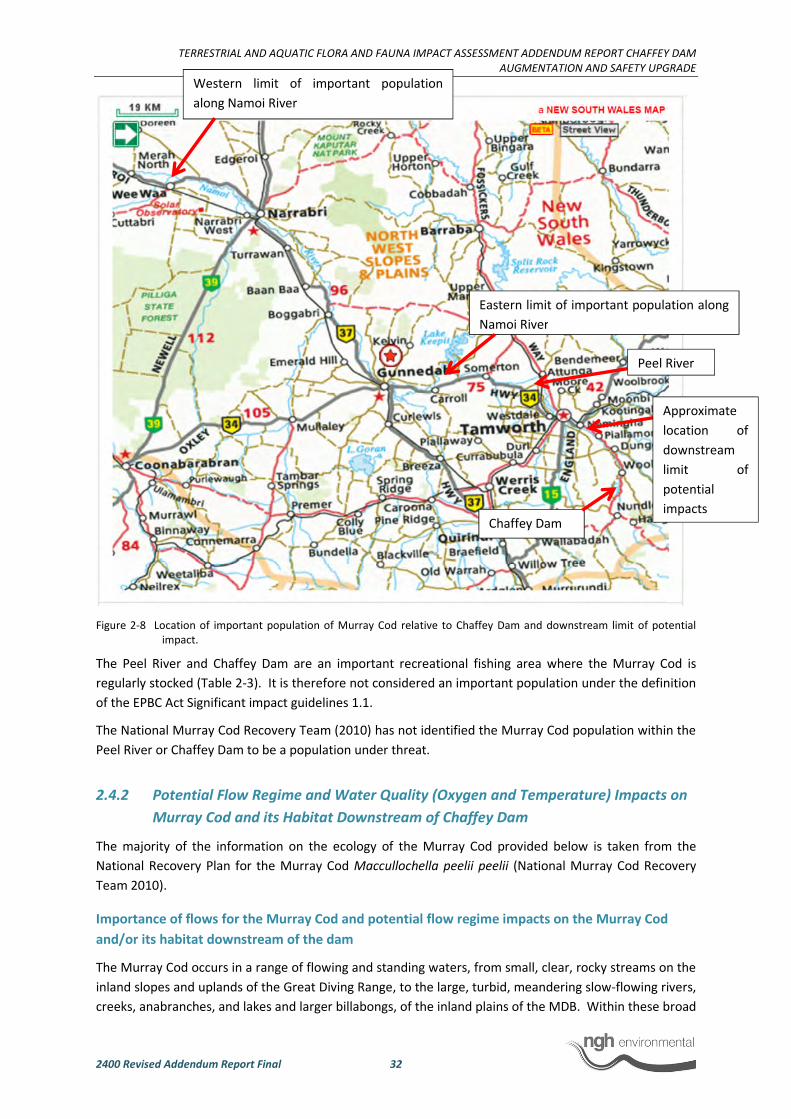
TERRESTRIAL AND AQUATIC FLORA AND FAUNA IMPACT ASSESSMENT ADDENDUM REPORT CHAFFEY DAM
AUGMENTATION AND SAFETY UPGRADE
2400 Revised Addendum Report Final 32
Figure 2-8 Location of important population of Murray Cod relative to Chaffey Dam and downstream limit of potential
impact.
The Peel River and Chaffey Dam are an important recreational fishing area where the Murray Cod is
regularly stocked (Table 2-3). It is therefore not considered an important population under the definition
of the EPBC Act Significant impact guidelines 1.1.
The National Murray Cod Recovery Team (2010) has not identified the Murray Cod population within the
Peel River or Chaffey Dam to be a population under threat.
2.4.2 Potential Flow Regime and Water Quality (Oxygen and Temperature) Impacts on
Murray Cod and its Habitat Downstream of Chaffey Dam
The majority of the information on the ecology of the Murray Cod provided below is taken from the
National Recovery Plan for the Murray Cod Maccullochella peelii peelii (National Murray Cod Recovery
Team 2010).
Importance of flows for the Murray Cod and potential flow regime impacts on the Murray Cod
and/or its habitat downstream of the dam
The Murray Cod occurs in a range of flowing and standing waters, from small, clear, rocky streams on the
inland slopes and uplands of the Great Diving Range, to the large, turbid, meandering slow-flowing rivers,
creeks, anabranches, and lakes and larger billabongs, of the inland plains of the MDB. Within these broad
Chaffey Dam
Eastern limit of important population along
Namoi River
Peel River
Western limit of important population
along Namoi River
Approximate
location of
downstream
limit of
potential
impacts

TERRESTRIAL AND AQUATIC FLORA AND FAUNA IMPACT ASSESSMENT ADDENDUM REPORT CHAFFEY DAM
AUGMENTATION AND SAFETY UPGRADE
2400 Revised Addendum Report Final 33
habitat types, Murray Cod are usually found associated with complex structural cover such as large rocks,
large snags and smaller structural woody habitat, undercut banks and over-hanging vegetation (Dakin
and Kesteven 1938; Lake 1967b; Langtry in Cadwallader 1977; Cadwallader 1979; Cadwallader and
Backhouse 1983; Harris and Rowland 1996; Koehn 1996, 2006; Rowland 1988a, 2005).
The species has an annual reproductive cycle and a short, defined, breeding season. Murray Cod form
pairs and spawn in spring-summer, in response to rising water temperatures of 16.5-23.5⁰C, with most
spawning thought to occur at around 20⁰C (Cadwallader and Gooley 1984; Gooley et al.1995; Rowland
1985, 1998a). Reproduction appears largely dependent upon water temperature, with flooding or a rise
in water level apparently not required to initiate spawning (Rowland 1983a, b, 1988; Cadwallader and
Gooley 1985).
While spawning does not apparently require flooding, recruitment success appears to be strongly linked
to river flow, with good year classes in some rivers coinciding with a rise in water level or flooding at or
soon after spawning (Rowland 2005; Ye et al. 2000). Recruitment success is likely to be linked to timing,
duration and water quality, especially temperature, of flows, and flooding in spring appears to provide
optimum conditions for survival and recruitment of larvae and juveniles in rivers (Kearney and Kildea
2001; Rowland 1985, 1989, 1998a).
Considering the species inhabits a range of flowing and standing water, any potential changes to the flow
regime is unlikely to substantially affect the distribution of the Murray Cod. Furthermore, Chaffey Dam
currently impacts the natural flow regime of the Peel River. The assessment of potential impacts as a
result of the proposed Chaffey Dam augmentation therefore needs to be assessed in this context that is
whether existing flow regime impacts have the potential to be exacerbated following the augmentation.
Considering the ecology of the Murray Cod, any flow regime changes including magnitude, timing and
duration, are likely to be more detrimental at the recruitment stage of its lifecycle.
Outflows from Chaffey Dam through the morning glory spillway comprise unregulated spills and
regulated releases via the multi-level offtake tower. The rate of unregulated spills through the morning
glory spillway depends on its hydraulic characteristics, which are defined by the dimensions of the crest
and throat. The rate of outflow for a given depth of water above the crest is characterized by a stage-
discharge relationship. The raised morning glory spillway has been designed to achieve a stage-discharge
relationship which is a close match to the existing (Black and Veatch 2012).
A hydrologic model was developed to simulate the operation of Chaffey Dam over the climatic sequence
between 1892 and 2008. The model simulates river flows, dam storage, water extraction, losses and
operation, irrigation demands and water sharing plan rules (NSW Office of Water 2010a). The model
results assume operational rules which precede the Peel Valley Water Sharing Plan. However, they are
useful in demonstrating the impact of augmentation alone on the downstream hydrologic regime.
The results are presented in Figure 2-9 for the Peel River in the form of a flow duration curve- for a site
located downstream of Chaffey Dam at Piallamore. A flow duration curve shows the percentage of time
that the range of flows in a stream are likely to be equalled or exceeded. The effect of river regulation is
most significant in this reach of the Peel River due to the limited number of tributaries contributing to
flows at this location and because many diversions of ordered water occur downstream of this point
(NSW Office of Water 2010a).

TERRESTRIAL AND AQUATIC FLORA AND FAUNA IMPACT ASSESSMENT ADDENDUM REPORT CHAFFEY DAM
AUGMENTATION AND SAFETY UPGRADE
2400 Revised Addendum Report Final 34
Figure 2-9 Impact of river regulation at Piallamore (all year flow) (NSW Office of Water 2010a)
The results show very little difference in flow regime between the current and enlarged dam
configurations. For example, results for the current dam size show that a flow of 200 ML/day is equalled
or exceeded approximately 20% of the time. This is also the case for the enlarged dam configuration.
Without implementation of the Water Sharing Plan for the Peel Valley Regulated, Unregulated, Alluvium
and Fractured Rock Water Sources 2010, data analysis suggests that annual average flows in the Peel
River immediately below the dam would decrease by about two per cent compared to existing conditions
as a result of the raising of the dam wall and increase in full supply level (GHD 2008b). More specifically,
the proposed augmentation is likely to increase the volumes of low flows while reducing the flow
volumes for high flows during summer. Compared to the percentage changes in summer flows, the
impact of the proposed augmentation on winter flows would be more pronounced. Furthermore, low
flow volumes appear to have increased, while mid and high flow volumes decreased. The degree of
impact diminishes further downstream on approach to Tamworth. Considering this, the existing flow
regime impacts as a result of the dam are unlikely to be exacerbated to a substantial degree that it would
affect the life cycle of the Murray Cod. Furthermore, the environmental contingency allowance which
would be made available following augmentation has the potential to be used to improve recruitment of
the Murray Cod.
Environmental releases
Clause 31 of the Peel Valley Water Sharing Plan (the Plan) provides provisions in relation to
environmental release rules for Chaffey Dam and requires that a minimum daily release of 3ML be made,
both prior to and following augmentation of the reservoir to 100 GL.
Under the Plan the provision of environmental releases above the minimum daily release will change
following augmentation. The current environmental release provision requires a total of 1,600 ML to be
released over seven days. Following augmentation of Chaffey Dam, Clause 31(2) requires the
implementation of an environmental contingency allowance (ECA) of 5,000 ML, which may be released
over any period of time at the discretion of the NSW Environmental Water Manager. The current

TERRESTRIAL AND AQUATIC FLORA AND FAUNA IMPACT ASSESSMENT ADDENDUM REPORT CHAFFEY DAM AUGMENTATION AND SAFETY UPGRADE
2400 Revised Addendum Report Final 35
environmental release provisions also stipulate a peak flow of 500ML/day on day 2 of the seven day
period, however, after augmentation the magnitude and timing of releases is not prescribed.
At present, environmental releases are only provided once a minimum storage volume is reached, only in
certain months of the year and only if flood flows of a given magnitude have not occurred. None of these
conditions apply after augmentation. The background document to the Plan (NSW Office of Water 2010)
states that although magnitude, timing and duration of environmental releases after augmentation is not
prescribed, the ECA is likely to be used as a stimulus flow over seven days with a peak on day 2 of 1,200
ML/day.
The change in management of environmental releases from pre to post augmentation offers more
environmental water and greater flexibility in its release, ensuring environmental outcomes are
maximised. In the specific case of the Murray Cod, if environmental releases are proposed during the
breeding season of the Murray Cod (late Spring to early summer), they have the potential to increase
recruitment success. However, there is a need to consider all environmental assets of the Peel River to
maximise the ecological benefits of the ECA. Environmental Water Delivery: Namoi River (Barma Water
Resources et al. 2012) provides information on the environmental assets and potential options for
environmental water use in the Namoi catchment including at Chaffey Dam. The document provides
recommendations on water uses to best meet desirable ecological outcomes for the Peel River and
monitoring requirements.
Potential physical habitat modifications
In a study on the downstream geomorphic impacts of the existing dam, Gorrick (2004) found that floods
of low to moderate frequency have undergone reductions of around 90% for all events up to the 1 in 50
AEP decreasing to 24% for the 1 in 200 AEP. Under such flow regime changes it would be expected that
the downstream system would undergo significant geomorphic change. However, Gorrick (2004) found
that the geomorphic response to the altered flow regime has been largely limited to the development of
in-channel benches and pool infilling downstream of the two major tributaries (Duncans and Dungowan
Creeks). Gorrick (2004) attributes the limited geomorphic change to a number of intrinsic factors
controlling the form of the Peel River downstream of Chaffey Dam. These include armoured gravel
surfaces, well-vegetated cohesive banks, limited sediment inputs and the dissipation of flood waters
across relatively wide floodplains in comparison to channel width. Hence, it is considered the relatively
minor changes flow regime generated by the augmentation would not result in further significant
geomorphic change to the downstream river form. The physical habitat of the Murray Cod downstream
of Chaffey Dam is therefore unlikely to be substantially modified compared to existing conditions,
especially as the Murray Cod is known to inhabit a large range of habitats and flow conditions.
Potential downstream flow regime impacts during construction
To enable construction activities to be carried out and to reduce the risk of flood flows discharging
through the incomplete spillway, the reservoir will be required to be maintained at approximately 2 m or
more below the current FSL. If the reservoir is at or near FSL at the commencement of construction, it is
proposed to draw the reservoir down to 2 m below FSL immediately prior to and during works to
construct the upgraded morning glory spillway. During this period the inflows and any downstream
demand will be managed by operating the valves within the morning glory structure to ensure
environmental and riparian flows are maintained.
Lowering of the storage level by 2 m will reduce the storage volume of Chaffey Dam by 11 GL
(approximately 18%) and will be required for a maximum period of six months.

TERRESTRIAL AND AQUATIC FLORA AND FAUNA IMPACT ASSESSMENT ADDENDUM REPORT CHAFFEY DAM
AUGMENTATION AND SAFETY UPGRADE
2400 Revised Addendum Report Final 36
State Water has and continues to carry out consultation with the NSW Office of Water in regard to the
required drawdown. On 21 November 2012, State Water sought formal approval from the NSW
Commissioner for Water, NSW Office of Water, to maintain a temporary FSL 2 m below the current FSL
for a period of six months, from May 2014 onwards. This request has been made to enable construction
of the raised morning glory spillway.
Increased flows downstream have the potential to impact the lifecycle of the Murray Cod and may have a
positive impact on recruitment if undertaken at appropriate times. Recommended safeguards include a
requirement to prepare a water release management plan to manage the lowering of the dam during
construction to ensure downstream impacts are minimised.
Similarly, flood flows could occur through the incomplete auxiliary spillway during reconfiguration of the
fuseplug, potentially resulting in the loss of soil and rock downstream. The distribution of soil and rock
downstream has the potential to infill the streambed and temporarily increase turbidity, thereby
reducing the suitability of water for downstream consumptive uses and potentially resulting in impacts to
aquatic ecosystems.
At the current FSL, a flood with a frequency of 1 in 1,000 years would be required for reservoir water
levels to reach the sill of the auxiliary spillway (Black & Veatch 2012). This is considered to be an
acceptably low level of risk. Therefore, the potential for the impacts associated with flood flows
discharging through the auxiliary spillway during construction to manifest, is considered to be very low.
Importance of temperature regime for the Murray Cod and potential water quality (oxygen and
temperature) impacts on the Murray Cod and/or its habitat downstream of the dam
The species has an annual reproductive cycle and a short, defined, breeding season. Murray Cod form
pairs and spawn in spring-summer, in response to rising water temperatures of 16.5-23.5⁰C, with most
spawning thought to occur at around 20⁰C (Cadwallader and Gooley 1984; Gooley et al.1995; Rowland
1985, 1998a). Murray Cod have been shown to spawn in the wild with water temperatures as low as 15oC
(Humphries 2004; Koehn and Harrington 2006). Reproduction appears largely dependent upon water
temperature, with flooding or a rise in water level apparently not required to initiate spawning (Rowland
1983a, b, 1988; Cadwallader and Gooley 1985). Eggs are laid on a hard substrate such as large structural
woody habitat, rocks and clay surfaces, while in ponds and dams, captive cod have spawned inside
hollow objects such as concrete pipes and metal drums, on fallen timber and directly on the substrate
(Cadwallader et al. 1979; Cadwallader and Gooley 1984; Gooley et al.1995; Rowland 1988a). Eggs hatch
after 4-13 days, depending on temperature (Cadwallader et al.1979; Cadwallader and Gooley 1984;
Kailola et al. 1993; Rowland 1988b, 1998, 2005). After several days at the spawning site, larvae rise in the
water column and drift with the current (Humphries et al. 2002; Koehn and Harrington 2005, 2006). Peak
abundance occurs in November, although larvae may be present for up to 10 weeks (Koehn and
Harrington 2006).
Chaffey Dam is subject to both thermal and oxygen stratification (MHL 2005; GHD 2007). Thermal
stratification in Chaffey Dam results in a warm upper layer of water (the epilimnion) overlying a cold
lower layer of water (the hypolimnion), separated by a transition layer (the thermocline). Thermal
stratification promotes oxygen stratification, which results in a depletion of oxygen in the hypolimnion.
This results in reduced water quality in the hypolimnion from anaerobic decomposition, including the
production of hydrogen sulphide and the release of phosphorus. When water is released from the
hypolimnion, both the cold temperature and reduced quality of the released water can reduce
downstream water quality. According to MHL (2005), augmentation of Chaffey Dam is predicted to:

TERRESTRIAL AND AQUATIC FLORA AND FAUNA IMPACT ASSESSMENT ADDENDUM REPORT CHAFFEY DAM
AUGMENTATION AND SAFETY UPGRADE
2400 Revised Addendum Report Final 37
• Increase the size of the epilimnion from 46 GL (78% of current reservoir volume) to 64 GL (64% of
augmented reservoir volume).
• Increase the size of the hypolimnion from 13 GL (22% of current reservoir volume) to 36 GL (36%
of augmented reservoir volume).
• Extend stratification longer into autumn.
According to MHL (2005), the epilimnion is sufficiently large to supply current water demands and an
increase in Tamworth’s supply to its full entitlement of 16,400 ML (provided the epilimnion water is of
sufficient quality).
The proposed works will raise the morning glory spillway offtake tower relative to the increase in FSL.
The depth from surface and thickness of the thermocline will not change as a result of augmentation,
because this is determined by local environmental factors such as seasonal weather variations and solar
radiation. Therefore, as a result of raising the offtake tower, the current ability to withdraw from above,
below or within the thermocline to access the highest quality water available will be retained. Should the
withdrawal of water through the multi-level offtake access colder, deeper water, MHL (2005) state that
the relatively low flow and slow downstream propagation will result in an equilibration of downstream
river temperatures to mean air temperature within a relatively short distance of the dam.
Therefore, it is considered that changes to the stratification layers within the reservoir as a result of the
augmentation will not result in a measurable reduction in downstream water quality compared to
existing conditions. When it occurs, cold water pollution is generally observed for a short period in mid
to late summer, which is outside the spawning and recruitment period of the Murray Cod (see below for
specific details on cold water pollution downstream of the dam).
Consequently, the current water quality impacts downstream of the dam (temperature and oxygen) on
the Murray Cod are unlikely to be substantially exacerbated compared to existing conditions. The
recommendation to review and amend the current operating protocol for water releases following
augmentation has the potential to further minimise cold water pollution and other downstream water
quality impacts.
Potential downstream water quality impacts during construction
As discussed above, construction activities may require the dam water level to be lowered. This would
only be required if the dam is at or within 2 m of the FSL during the construction period. This will likely
be required during construction works on the morning glory spillway. Depending on timing and quantity
of water released this may result in a number of potential downstream impacts including water quality
impacts (e.g. cold water pollution). Recommended safeguards include a requirement to prepare a water
release management plan to manage the lowering of the dam during construction to ensure downstream
impacts are minimised.
Extensive earthworks will be required as part of the proposed upgrade. Most of these would be
undertaken in close proximity to the Chaffey Dam reservoir and/or its tributaries, sometimes within the
waterways themselves.
These activities would include, but would not be limited to the excavation and stockpiling of rock and soil;
vegetation clearing, construction of roads and bridges. Most of these activities would be undertaken at
or immediately downstream of the dam wall except for the realignment of roads and bridges around the
Chaffey Dam reservoir. Use of a barge may also be required for the raising of the morning glory spillway.
Impacts on aquatic habitats and aquatic flora and fauna as a result of potential erosion and
sedimentation of waterbodies could include:

TERRESTRIAL AND AQUATIC FLORA AND FAUNA IMPACT ASSESSMENT ADDENDUM REPORT CHAFFEY DAM
AUGMENTATION AND SAFETY UPGRADE
2400 Revised Addendum Report Final 38
• Reduction of water quality such as increased turbidity and/or increased nutrient levels
• Reduction of light penetration (as a result of increased turbidity) and subsequent reduction of
aquatic macrophytes (loss of habitat)
• Increased potential for algal growth with potential for toxic algal blooms (as a result of increased
nutrients) resulting in negative impacts on aquatic fauna
• Potential sedimentation of aquatic habitats including but not limited to rocky areas, riffles and
macrophytes (loss of aquatic habitats)
These impacts have the potential to impact downstream areas as well as areas close to the earthworks or
construction activities.
Proposed works also have the potential to impact water quality through accidental chemical spills (e.g.
hydrocarbons, concrete). Potential pollution sources may include but not be limited to:
• Compound sites
• Barges and boats
• Construction plant
Recommended safeguards include the preparation of a soil and water management plan and safe work
method statements to avoid or minimise these impacts.
2.4.3 Potential Cold Water Pollution Impacts Downstream of Chaffey Dam Following
Augmentation
A desktop assessment of New South Wales dams ranked Chaffey Dam as a low priority in terms of cold
water pollution potential to downstream environments because of small discharge volumes and
predominately an extraction from shallow depths (and hence warm temperatures) (Preece 2004). Cold
water releases from Chaffey Dam were predicted by IESC Pty Ltd (1974) to lower the downstream
temperature by 6 to 10°C with the potential for resultant fish kills. Bishop and Harris (1990) reported
lower water temperatures later into summer and depressed temperatures for up to 50 km downstream
of Chaffey Dam. However, MHL (2005) state that due to the relatively low flow and slow downstream
propagation, the majority of the equilibration of downstream river temperatures to mean air
temperature would occur within a relatively short distance of the dam. Differences in water
temperatures of the Peel River upstream and downstream of Chaffey Dam were simulated with a
reservoir water quality model over two periods from 1995-1997 and 2005-2007. The simulated water
temperature is often up to 10°C cooler during January and February because of extraction of
hypolimnetic cool waters (GHD 2008b).
Chaffey Dam has a multi-level offtake (i.e. intake) tower that can be configured to extract water from a
range of reservoir depths. In particular water from the reservoir can be extracted from two different
depths simultaneously through the multi-level intake. Hence, there is opportunity to control the
temperature of the released waters during the period of thermal stratification through extraction of
cooler deep (hypolimnetic) waters, warmer surface (epilimnetic) waters or a blend. While the multi-level
offtake tower is typically positioned within the thermocline there is some release from the hypolimnion
and surface waters (Preece 2004). The operating protocol for the mutli-level offtake also needs to
consider the management of algal blooms which requires the release of hypolimnetic waters which can
result in the release of colder waters. Data provided by State Water Corporation indicates that cold
water pollution occurs during a short time over the summer period, with temperatures around 7.5°C
cooler downstream of the dam compared to upstream (Figure 2-10). Cold water pollution therefore does
TERRESTRIAL AND AQUATIC FLORA AND FAUNA IMPACT ASSESSMENT ADDENDUM REPORT CHAFFEY DAM
AUGMENTATION AND SAFETY UPGRADE
2400 Revised Addendum Report Final 39
occur at Chaffey Dam. However, the intensity and duration of cold water pollution is mostly linked to the
successful use of the multi-level offtake in accordance with the operating protocol. As the proposed
augmentation of Chaffey Dam would include the upgrade of the multi-level offtake to manage cold water
pollution, the impact of cold water pollution are unlikely to be worse than current conditions.
Figure 2-10 Recorded water temperatures downstream and upstream of the dam between July 2011 and
March 2012 (State Water Corporation 2013).
Based on this, cold water pollution following the augmentation of Chaffey Dam would be similar to
existing conditions:
• Cold water pollution would generally occur during the summer period.
• Based on simulations, water temperature downstream of the dam during this period can be up
to 10 degrees cooler than upstream.
The depressed temperatures have the potential to be felt for up to 50 km downstream of Chaffey Dam,
though due to the relatively low flow and slow downstream propagation, equilibration of downstream
river temperatures to mean air temperature would occur within a relatively short distance of the dam.
2.4.4 Cold Water Pollution Management
The Stage 1 of the NSW Cold Water Pollution Strategy (NSW Cold Water Pollution Interagency Group,
2012) has cold water mitigation actions including the implementation of improved operating protocols
(including monitoring) and structural modifications recommended by the NSW Environmental Trust
Project for the priority dams that already have selective off-take capability. This includes Chaffey Dam.
For Chaffey Dam, NSW Cold Water Pollution Interagency Group (2012) provides the following suggestions
to meet the requirement of the Water Management Act 2000 in regards to cold water releases:
• The licence holder is to prepare and submit an approved operating protocol for the management
of cold water pollution in accordance with the Guidelines for managing cold water releases from
high priority dams (NOW, 2011).
Peel River Upstream and Downstream temps 11/12
0.0
5.0
10.0
15.0
20.0
25.0
30.0
1/07/2011
15/07/2011
29/07/2011
12/08/2011
26/08/2011
9/09/2011
23/09/2011
7/10/2011
21/10/2011
4/11/2011
18/11/2011
2/12/2011
16/12/2011
30/12/2011
13/01/2012
27/01/2012
10/02/2012
24/02/2012
9/03/2012
23/03/2012
oC
Upstream temps 11/12
Downstream Temps 11/12

TERRESTRIAL AND AQUATIC FLORA AND FAUNA IMPACT ASSESSMENT ADDENDUM REPORT CHAFFEY DAM
AUGMENTATION AND SAFETY UPGRADE
2400 Revised Addendum Report Final 40
• The licence holder is to use its best endeavours to operate the dam according to the operating
protocol.
• The licence holder will provide within three months of the end of each year or annually on
agreed date a report to Office of Water detailing its performance against the protocol, including
instances of and reasons for departure from the operating protocol, outcomes achieved (in
accordance with NOW 2011) and proposals for improvement in performance.
The current operating protocol for Chaffey Dam, which includes cold water and algal management has
been prepared and is used in accordance with the above requirements and minimises cold water
pollution which occurs downstream of Chaffey dam (refer to Section 2.4.3). The proposed augmentation
of the dam would not increase the impact of cold water pollution as the multi-level offtake would be
upgraded and raised to ensure water from various water depths can continue to be used to minimise
impacts.
2.4.5 Mitigation Measures
The following provides the list of mitigation measures for aquatic biodiversity as provided in
nghenvironmental (2012) and amended as required to comply with the SEWPaC requirements as well as
DPI (fisheries) comments on the PIR dated 17 April 2013:
TERRESTRIAL AND AQUATIC FLORA AND FAUNA IMPACT ASSESSMENT ADDENDUM REPORT CHAFFEY DAM AUGMENTATION AND SAFETY UPGRADE
2400 Revised Addendum Report Final 41
Mitigation measure Objective Threshold for corrective action Corrective action
Should large woody debris need to be removed for any
construction activities the following management
guidelines would be followed in accordance with the
Key Threatening processes in NSW Removal of large
woody debris from NSW rivers and streams prime fact
11 (DPI 2005):
Lopping (trimming) should be considered as a first
option.
Instream realignment should be considered as the next
option.
If realignment is unfeasible, relocation within the river
channel is preferable to removal.
Removal should be considered as a last resort.
Minimise impacts to
important fish habitat
Not Applicable Not Applicable
Removal/relocation of snags would be undertaken so
as to cause the least disturbance to the bed or nearby
sensitive aquatic habitat. An aquatic ecologist would
be present on site when working with snags that
require lopping, realignment, relocation and/or
removal.
Minimise impacts to
important fish habitat
Not Applicable Not Applicable
An Erosion and Sediment Control Plan (ESCP) will be
prepared detailing erosion and sediment controls and
other water quality controls that would be put in place
to avoid or minimise impacts to waterways during
construction activities. The ESCP would be prepared in
accordance with the NSW Soils and Construction –
Managing Urban Stormwater Volume 1 and 2. The
ESCP would be reviewed by State Water's Senior
Environmental Officer prior to commencement of
works.
Avoid or minimise impacts
to water quality and fish
habitat as a result of
potential erosion and
sedimentation.
The ESCP should include
thresholds for corrective actions
and the corrective actions that
would need to be implemented.
The ESCP will include thresholds for
corrective actions and the corrective
actions that would need to be
implemented.
Work method statements (WMS) would be prepared
for high risk activities within waterways (e.g. bridge
Avoid or minimise impacts
to water quality and fish
As per safeguard, the WMS
should include thresholds for
As per safeguard, the WMS should include
thresholds for corrective actions and the

TERRESTRIAL AND AQUATIC FLORA AND FAUNA IMPACT ASSESSMENT ADDENDUM REPORT CHAFFEY DAM AUGMENTATION AND SAFETY UPGRADE
2400 Revised Addendum Report Final 42
Mitigation measure Objective Threshold for corrective action Corrective action
construction). The WMS would include, but not be
limited to, the following and be reviewed by State
Water's Senior Environmental Officer prior to
commencement of works:
Description of works/activities including machinery.
Outline of the sequence of the works/activities
An environmental risk assessment to determine
potential risks to discrete work elements or activities
likely to affect the environment.
A map indicating the locations of likely potential
environmental impacts.
Evaluation of methods to reduce environmental risks.
Mitigation measures to reduce environmental risks
(including those listed in this assessment).
A process for assessing the performance of the
implemented mitigation measures.
A process for resolving environmental issues and
conflicts.
Emergency procedures for chemical spills and other
potential emergency incidents.
habitat during high risk
construction activities.
corrective actions and the
corrective actions that would
need to be implemented.
corrective actions that would need to be
implemented.
Compound and stockpile sites should be located at
least 40 m from any waterways where possible and
should be adequately protected to avoid or minimise
any potential pollution of waterways through
adequate erosion and sediment controls or impervious
bunds.
Avoid or minimise impacts
to water quality and fish
habitat as a result of
potential erosion and
sedimentation and/or
chemical spills.
Waterway is impacted through
erosion and sedimentation and
or accidental spills
Relocate compound sites further from
waterway to ensure impacts are avoided in
the future.
Stage works so that construction activities that need to
be undertaken within waterways are undertaken
during low dam levels (bridge construction).
Minimise impacts to water
quality and fish habitat.
Not applicable Not applicable
Water releases required to reduce the dam level
during the construction period should be appropriately
Avoid and or minimise
downstream impacts such
The water release management
plan would be prepared and
Thresholds and actions required are
currently provided in the current operating

TERRESTRIAL AND AQUATIC FLORA AND FAUNA IMPACT ASSESSMENT ADDENDUM REPORT CHAFFEY DAM AUGMENTATION AND SAFETY UPGRADE
2400 Revised Addendum Report Final 43
Mitigation measure Objective Threshold for corrective action Corrective action
managed. A water release management plan will be
prepared and the following considered:
Where possible use water releases undertaken as part
of the water sharing plan to reduced water levels
where required for construction activities.
Adequate monitoring of water quality (temperature,
algal blooms) should be undertaken to ensure water
quality impacts due to release of water are avoided or
minimised. The multi-level intake should be used in an
effective manner to minimise potential water quality
impacts.
The water release management plan should be
developed in consultation with all relevant
stakeholders including but not limited to State Water
and DPI (Fisheries).
as cold water pollution
during the release of water
to temporarily lower the
dam water level for
construction purposes.
include temperature and algal
bloom thresholds to ensure
downstream impacts are avoid
or minimise.
Thresholds and actions required
are currently provided in the
current operating protocol of the
mutli-level offtake and should be
taken into consideration in the
development of the water
release management plan for
construction purposes.
protocol of the mutli-level offtake and
should be taken into consideration in the
development of the water release
management plan for construction
purposes.
The riparian zone of the Peel River should be replanted
at the new full supply level along upstream waterways
for a minimum of 10 m from the new FSL and along the
shoreline of the dam where practicable, particularly in
areas identified as having a high risk of erosion.
Revegetation should be undertaken using natives
species of local provenance.
A riparian vegetation plan would be prepared in
consultation with DPI (fisheries).
Improve aquatic habitat
quality following
construction.
Multi-year monitoring and
reporting of the riparian zone
should be undertaken following
replanting to ensure riparian
zone is adequately established
and provides bank protection.
Corrective actions, such as further
planting, would be determined as required
during the monitoring and reporting
period.
The raising and design of the multi-level off-take tower
will be undertaken so as cold water pollution and algal
bloom impacts can be adequately managed (i.e. allow
for releases of water from various depths
independently and/or concurrently to allow mixing of
water if required to mitigate cold water pollution).
Avoid or minimise
downstream cold water
pollution and algal blooms
during operation.
Not applicable Not applicable
The release of water during operation will be
undertaken under the Water Sharing Plan for the Peel
Improve the aquatic
ecosystem through the
Multi-year monitoring and
reporting of the use of the ECA
Multi-year monitoring and reporting of the
use of the ECA would need to be
TERRESTRIAL AND AQUATIC FLORA AND FAUNA IMPACT ASSESSMENT ADDENDUM REPORT CHAFFEY DAM AUGMENTATION AND SAFETY UPGRADE
2400 Revised Addendum Report Final 44
Mitigation measure Objective Threshold for corrective action Corrective action
Valley Regulated, Unregulated, Alluvium and Fractured
Rock Water Sources 2010 (NOW 2010). An adequate
operating protocol for the use of the ECA will be
developed to provide the best ecological outcome.
The operating protocol should consider the
Environmental Water Delivery: Namoi River (Barma
Water Resources et al. 2012) which provides
information on the environmental assets and potential
options for environmental water use in the Namoi
catchment including at Chaffey Dam. It should also
include monitoring requirements, as described in
Barma Water Resources et al. (2012), to assess the
success of the releases. The operating protocol should
be developed in consultation with all relevant
stakeholders including but not limited to State Water
and DPI (Fisheries).
appropriate use of the ECA. would need to be undertaken as
per safeguard and in accordance
with Barma Water Resources et
al. (2012). This would assess the
success of the use of the ECA and
any corrective actions that would
be required.
undertaken as per safeguard and in
accordance with Barma Water Resources
et al. (2012). This would assess the success
of the use of the ECA and any corrective
actions that would be required.
The existing operating protocol for avoiding or
minimising cold water releases will be improved if
required in accordance with the guidelines for
managing cold water releases from high priority dams
(NOW 2011). The following will be considered:
The water to be released should match as closely as
possible the natural temperature regime, especially
during the spring, summer and autumn periods. The
natural seasonal temperature regime should be
determined through effective monitoring of upstream
and downstream reference sites.
The impact of water releases on temperatures
downstream will be monitored through the selection
of appropriately located downstream sites and
comparisons with reference locations.
The protocol would be followed in consultation with
relevant stakeholders including DPI (Fisheries).
Avoid or minimise
downstream cold water
pollution and algal blooms
during operation.
The existing operating protocol
would follow the guidelines for
managing cold water releases
from high priority dams (NOW
2011) which requires the
establishment of monthly targets
and performance criteria.
Multi-year monitoring and
reporting in accordance with the
guidelines for managing cold
water releases from high priority
dams (NOW 2011) would be
undertaken and the operating
protocol improved if required.
The operating protocol will be reviewed in
accordance with the guidelines for
managing cold water releases from high
priority dams (NOW 2011) which requires
the establishment of monthly targets and
performance criteria.
The operating protocol would be improved
if required, following multi-year
monitoring and reporting.

TERRESTRIAL AND AQUATIC FLORA AND FAUNA IMPACT ASSESSMENT ADDENDUM REPORT CHAFFEY DAM AUGMENTATION AND SAFETY UPGRADE
2400 Revised Addendum Report Final 45
Mitigation measure Objective Threshold for corrective action Corrective action
DPI-Fisheries is to be notified in accordance with the
DPI – Fisheries Fish Kill Protocol if any fish kills occur in
the vicinity of the works.
Minimise impacts to aquatic
biodiversity.
Fish kills occur during
construction.
Report fish kill in accordance with Fish kill
protocol
An incident emergency spill plan would be developed
and incorporated into the CEMP. The plan would
include measures to avoid spillages of fuels, chemicals,
and fluids into any adjacent/nearby waterways and an
emergency response plan. Emergency spill kits would
be kept onsite at all times. A boom would be at hand in
the case of any spills or material entering waterways.
Avoid or minimise impacts
to water quality.
A spill occurs within a waterway. The incident emergency spill plan would
include an emergency response plan with
corrective actions.
Exclusion zones for riparian zones that do not need to
be accessed would be established before works start
to avoid any disturbances of the banks.
Avoid disturbances to
riparian zones.
Not applicable. Riparian zones
would be designated as no go
zones as required.
Not applicable. Riparian zones would be
designated as no go zones as required.
Temporary works, flow diversion barriers and in-
stream sediment control barriers would be removed as
soon as practicable and in a manner that would not
exacerbate future channel erosion.
Minimise impacts to aquatic
habitats as a result of
temporary construction
structures.
Not applicable Not applicable
Detailed design and construction of the bridges would
be in accordance with requirements for fish passage
and in consultation with DPI (Fisheries) where
necessary.
Avoid impacts to fish
passage.
Designs would be reviewed by
DPI (fisheries) to ensure these
are in accordance with relevant
guidelines.
Designs would be reviewed by DPI
(fisheries) to ensure these are in
accordance with relevant guidelines.
Should detailed design determine that fish passage
needs to be temporarily blocked for construction
purposes, a permit under part 7 of the FM Act would
be sought.
Avoid or minimise impacts
to fish passage.
Permit would be required should
fish passage need to be
temporarily or permanently
blocked any time during
construction or operation.
Apply for permit.
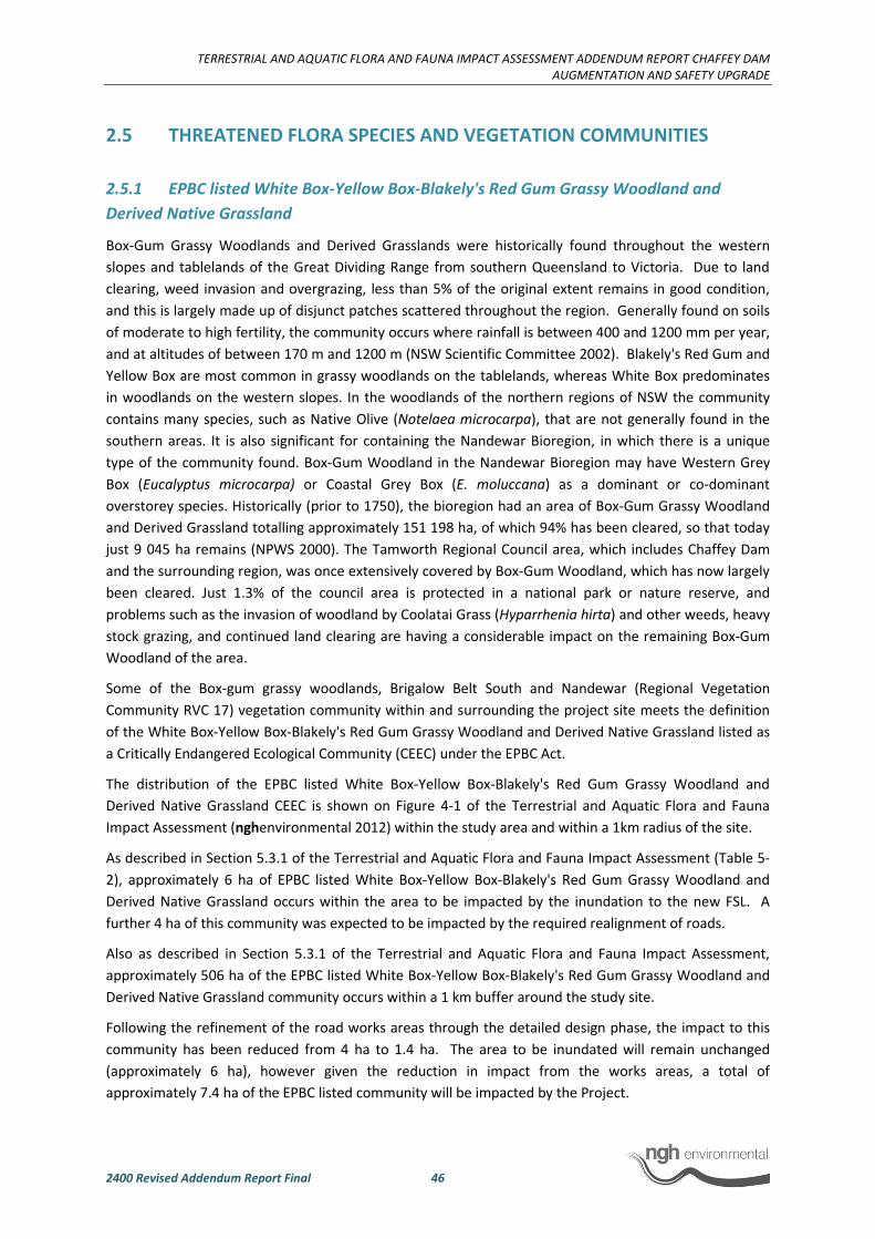
TERRESTRIAL AND AQUATIC FLORA AND FAUNA IMPACT ASSESSMENT ADDENDUM REPORT CHAFFEY DAM
AUGMENTATION AND SAFETY UPGRADE
2400 Revised Addendum Report Final 46
2.5 THREATENED FLORA SPECIES AND VEGETATION COMMUNITIES
2.5.1 EPBC listed White Box-Yellow Box-Blakely's Red Gum Grassy Woodland and
Derived Native Grassland
Box-Gum Grassy Woodlands and Derived Grasslands were historically found throughout the western
slopes and tablelands of the Great Dividing Range from southern Queensland to Victoria. Due to land
clearing, weed invasion and overgrazing, less than 5% of the original extent remains in good condition,
and this is largely made up of disjunct patches scattered throughout the region. Generally found on soils
of moderate to high fertility, the community occurs where rainfall is between 400 and 1200 mm per year,
and at altitudes of between 170 m and 1200 m (NSW Scientific Committee 2002). Blakely's Red Gum and
Yellow Box are most common in grassy woodlands on the tablelands, whereas White Box predominates
in woodlands on the western slopes. In the woodlands of the northern regions of NSW the community
contains many species, such as Native Olive (Notelaea microcarpa), that are not generally found in the
southern areas. It is also significant for containing the Nandewar Bioregion, in which there is a unique
type of the community found. Box-Gum Woodland in the Nandewar Bioregion may have Western Grey
Box (Eucalyptus microcarpa) or Coastal Grey Box (E. moluccana) as a dominant or co-dominant
overstorey species. Historically (prior to 1750), the bioregion had an area of Box-Gum Grassy Woodland
and Derived Grassland totalling approximately 151 198 ha, of which 94% has been cleared, so that today
just 9 045 ha remains (NPWS 2000). The Tamworth Regional Council area, which includes Chaffey Dam
and the surrounding region, was once extensively covered by Box-Gum Woodland, which has now largely
been cleared. Just 1.3% of the council area is protected in a national park or nature reserve, and
problems such as the invasion of woodland by Coolatai Grass (Hyparrhenia hirta) and other weeds, heavy
stock grazing, and continued land clearing are having a considerable impact on the remaining Box-Gum
Woodland of the area.
Some of the Box-gum grassy woodlands, Brigalow Belt South and Nandewar (Regional Vegetation
Community RVC 17) vegetation community within and surrounding the project site meets the definition
of the White Box-Yellow Box-Blakely's Red Gum Grassy Woodland and Derived Native Grassland listed as
a Critically Endangered Ecological Community (CEEC) under the EPBC Act.
The distribution of the EPBC listed White Box-Yellow Box-Blakely's Red Gum Grassy Woodland and
Derived Native Grassland CEEC is shown on Figure 4-1 of the Terrestrial and Aquatic Flora and Fauna
Impact Assessment (nghenvironmental 2012) within the study area and within a 1km radius of the site.
As described in Section 5.3.1 of the Terrestrial and Aquatic Flora and Fauna Impact Assessment (Table 5-
2), approximately 6 ha of EPBC listed White Box-Yellow Box-Blakely's Red Gum Grassy Woodland and
Derived Native Grassland occurs within the area to be impacted by the inundation to the new FSL. A
further 4 ha of this community was expected to be impacted by the required realignment of roads.
Also as described in Section 5.3.1 of the Terrestrial and Aquatic Flora and Fauna Impact Assessment,
approximately 506 ha of the EPBC listed White Box-Yellow Box-Blakely's Red Gum Grassy Woodland and
Derived Native Grassland community occurs within a 1 km buffer around the study site.
Following the refinement of the road works areas through the detailed design phase, the impact to this
community has been reduced from 4 ha to 1.4 ha. The area to be inundated will remain unchanged
(approximately 6 ha), however given the reduction in impact from the works areas, a total of
approximately 7.4 ha of the EPBC listed community will be impacted by the Project.
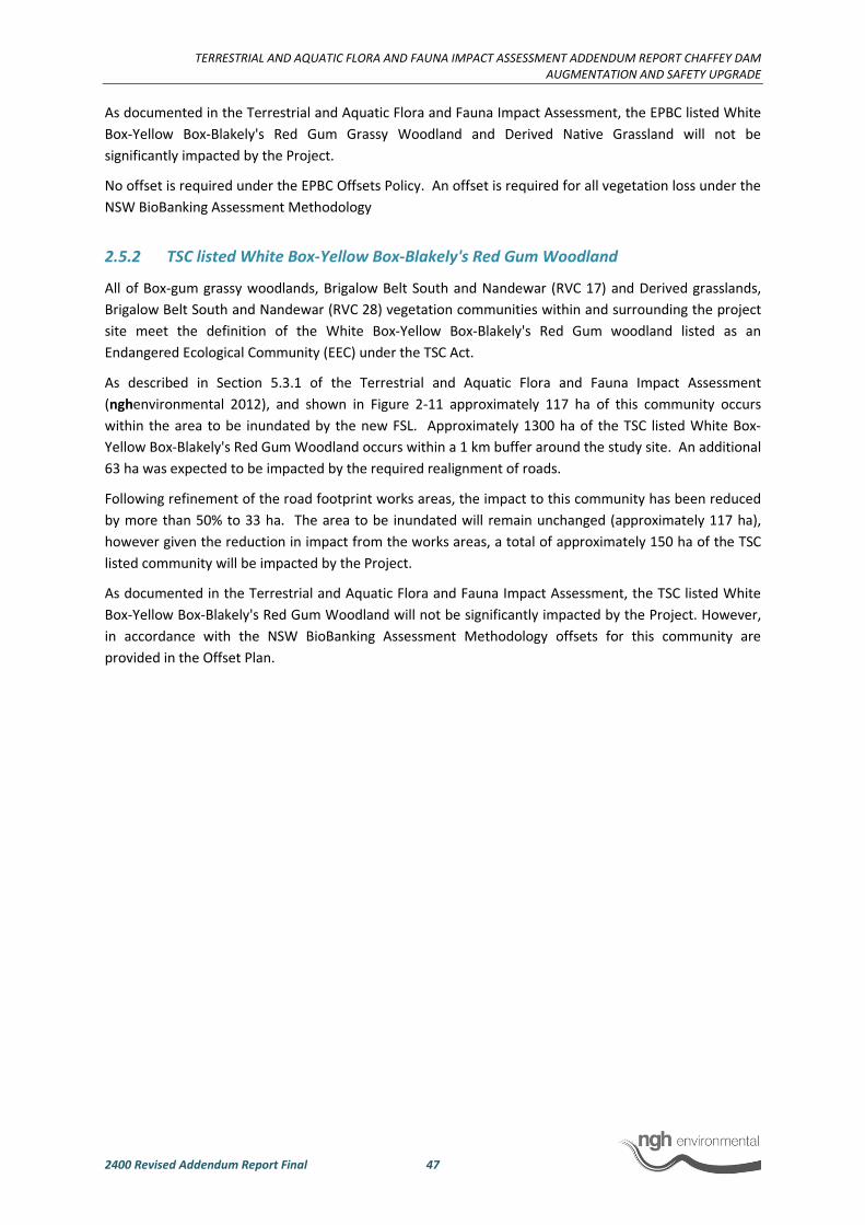
TERRESTRIAL AND AQUATIC FLORA AND FAUNA IMPACT ASSESSMENT ADDENDUM REPORT CHAFFEY DAM
AUGMENTATION AND SAFETY UPGRADE
2400 Revised Addendum Report Final 47
As documented in the Terrestrial and Aquatic Flora and Fauna Impact Assessment, the EPBC listed White
Box-Yellow Box-Blakely's Red Gum Grassy Woodland and Derived Native Grassland will not be
significantly impacted by the Project.
No offset is required under the EPBC Offsets Policy. An offset is required for all vegetation loss under the
NSW BioBanking Assessment Methodology
2.5.2 TSC listed White Box-Yellow Box-Blakely's Red Gum Woodland
All of Box-gum grassy woodlands, Brigalow Belt South and Nandewar (RVC 17) and Derived grasslands,
Brigalow Belt South and Nandewar (RVC 28) vegetation communities within and surrounding the project
site meet the definition of the White Box-Yellow Box-Blakely's Red Gum woodland listed as an
Endangered Ecological Community (EEC) under the TSC Act.
As described in Section 5.3.1 of the Terrestrial and Aquatic Flora and Fauna Impact Assessment
(nghenvironmental 2012), and shown in Figure 2-11 approximately 117 ha of this community occurs
within the area to be inundated by the new FSL. Approximately 1300 ha of the TSC listed White Box-
Yellow Box-Blakely's Red Gum Woodland occurs within a 1 km buffer around the study site. An additional
63 ha was expected to be impacted by the required realignment of roads.
Following refinement of the road footprint works areas, the impact to this community has been reduced
by more than 50% to 33 ha. The area to be inundated will remain unchanged (approximately 117 ha),
however given the reduction in impact from the works areas, a total of approximately 150 ha of the TSC
listed community will be impacted by the Project.
As documented in the Terrestrial and Aquatic Flora and Fauna Impact Assessment, the TSC listed White
Box-Yellow Box-Blakely's Red Gum Woodland will not be significantly impacted by the Project. However,
in accordance with the NSW BioBanking Assessment Methodology offsets for this community are
provided in the Offset Plan.
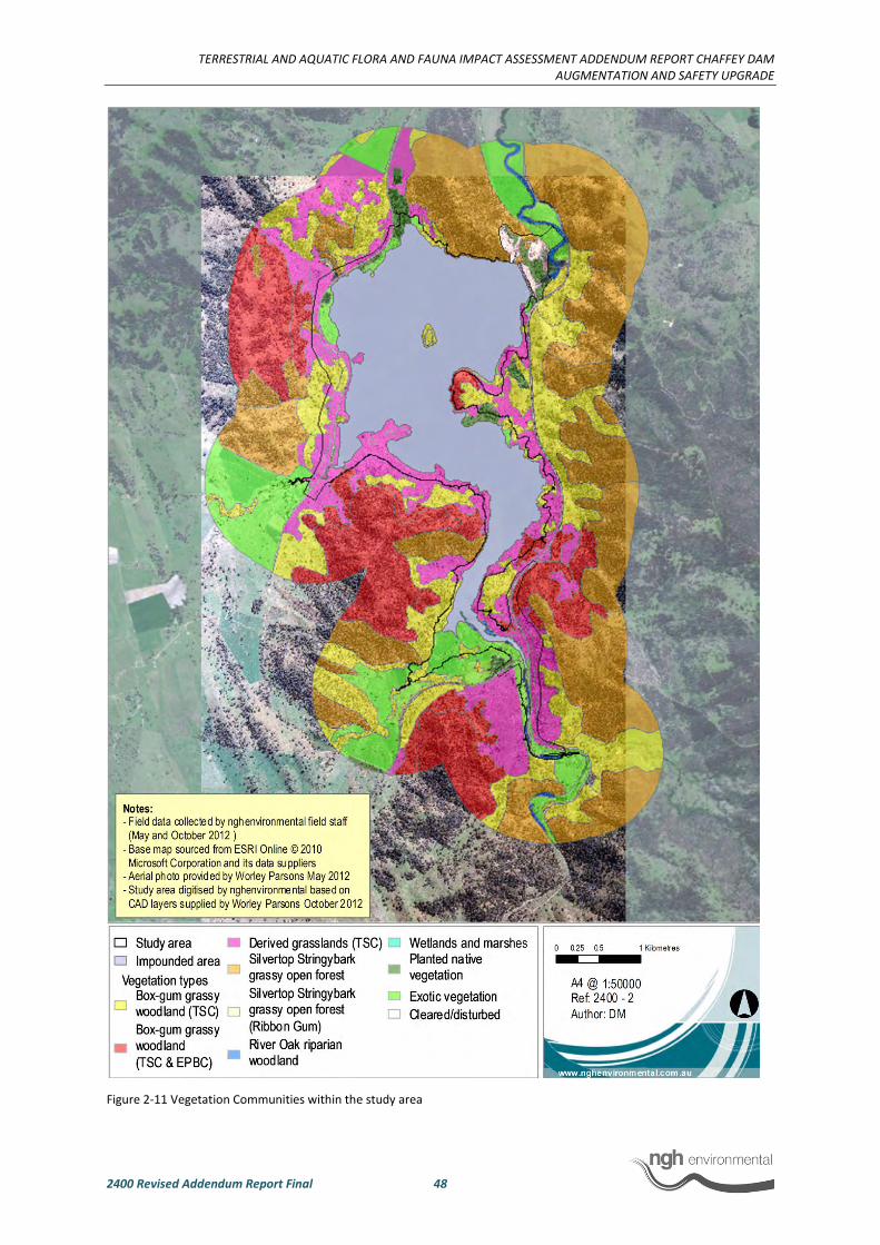
TERRESTRIAL AND AQUATIC FLORA AND FAUNA IMPACT ASSESSMENT ADDENDUM REPORT CHAFFEY DAM
AUGMENTATION AND SAFETY UPGRADE
2400 Revised Addendum Report Final 48
Figure 2-11 Vegetation Communities within the study area

TERRESTRIAL AND AQUATIC FLORA AND FAUNA IMPACT ASSESSMENT ADDENDUM REPORT CHAFFEY DAM
AUGMENTATION AND SAFETY UPGRADE
2400 Revised Addendum Report Final 49
2.5.3 Small Snake Orchid and Euphrasia arguta
The Small Snake Orchid (Diuris pedunculata) is listed as endangered under the TSC Act and the EPBC Act.
Euphrasia arguta is listed as critically endangered under the EPBC Act.
Table 3-2 and Figure 3-1 of the Terrestrial and Aquatic Flora and Fauna Impact Assessment
(nghenvironmental 2012) documents the location of targeted surveys and the associated survey effort
for these species during the original survey of the site.
Targeted searches were carried out in suitable habitat for these species during October 2012. Survey
timing was considered suitable for the Small Snake Orchid. Although not optimal, the survey timing was
also considered suitable for detecting Euphrasia arguta given that flowering has previously been
recorded in October. Further, it would have been possible to identify this species in its vegetative state if
it was not flowering at the time of survey.
As documented on the Terrestrial and Aquatic Flora and Fauna Impact Assessment, targeted surveys did
not detect these species and it is considered unlikely that the Small Snake Orchid or Euphrasia arguta
occur within the study area and that they are unlikely to be impacted by the Project.
The locations of nearest records for the Small Snake Orchid and Euphrasia arguta are provided in the
Habitat Evaluation attached as Appendix B to the Terrestrial and Aquatic Flora and Fauna Impact
Assessment (nghenvironmental 2012), Appendix 8 to the EIS (WorleyParsons 2012).
2.5.4 Justification for not targeting Eucalyptus rubida subsp. barbigerorum, Thesium
australe and Bothriochloa biloba as part of this assessment.
The potential for these species to be present at the development site and to be impacted by the
proposed works was assessed within the habitat evaluation included as Appendix B of nghenvironmental
2012. Further justification for not specifically targeting these species as part of the assessment is as
follows:
Eucalyptus rubida subsp. barbigerorum – As stated in the habitat evaluation, this species is a conspicuous
species. It may be detected at any time of year and during the course of the original vegetation surveys,
almost all of the areas of impact were traversed by vehicle or foot. This species was not detected and no
further targeted surveys were considered warranted.
Thesium australe – Potential habitat for this species was present at the site in localised areas and was not
of high quality. Additionally, the nearest record of the species is approximately 50 km north-east of the
site. Accordingly, it was considered unlikely that it would occur at the site.
The timing and location of the targeted flora surveys carried out at the site in spring (October) 2012
would have also been suitable for detecting this species and it was not identified.
Bothriochloa biloba – Heavier soils with which this species is associated were present at the site however,
not the preferred brown or black clays. One record from 1997 was located in Nundle approximately 10
km from the site.

TERRESTRIAL AND AQUATIC FLORA AND FAUNA IMPACT ASSESSMENT ADDENDUM REPORT CHAFFEY DAM
AUGMENTATION AND SAFETY UPGRADE
2400 Revised Addendum Report Final 50
2.6 THREATENED SPECIES HABITAT AVAILABILITY
2.6.1 Historical threatened species data
In preparing the Terrestrial and Aquatic Flora and Fauna Impact Assessment (nghenvironmental 2012),
the following databases were searched for records of EPBC Act and TSC Act listed threatened species
previously recorded within a 10 km radius of the site:
• Primary Industries Fisheries Records viewer
• OEH Bionet Wildlife Atlas:
• EPBC Protected Matters Search tool
The results of database searches were detailed in Appendix A of nghenvironmental (2012) (Appendix 8 of
the EIS). Appendix B of nghenvironmental (2012) provides a threatened species evaluation table that
assesses the likelihood of occurrence and the potential for impact on those species revealed in database
searches.
In summary, the database searches returned three trees, three shrubs, four forbs (including one orchid)
and two grasses listed as threatened that occur or have the potential to occur within 10 km of the study
site. Forty-two migratory or threatened terrestrial fauna species and/or their potential habitats have
been recorded within 10 km of Chaffey Dam. Of these species, 16 are listed under the TSC Act, and 25
under the EPBC Act. Five of these threatened fauna species and three of the listed migratory species
have been recorded within the study area since 1990; the Brown Treecreeper, Speckled Warbler, Little
Lorikeet, Border Thick-tailed Gecko, Booroolong Frog, White-bellied Sea-eagle, Rainbow Bee-eater and
Great Egret.
Appendix A shows the NSW OEH Wildlife Atlas data1 of records within 10 km of the site and 1 km of the
site and notes the EPBC Act status of TSC Act listed Species. The EPBC Act Protected Matters search tool
does not provide location records of threatened species predicted to occur.
These are historical records of threatened flora and fauna species within a 1 km radius of Chaffey Dam,
and are in addition to those detected by nghenvironmental in 2012 and NWES in 2013. Record locations
for Booroolong frogs were not provided in NWES 2009.
Targeted surveys and threatened species evaluations carried out by nghenvironmental (2012) for the EIS
ruled out the likelihood of impacts on all but one fauna species (Booroolong Frog) and one flora species
(Queensland Bluegrass).
Forty-two migratory or threatened terrestrial fauna species and/or their potential habitats have been
recorded within 10 km of Chaffey Dam. Of these species, 16 are listed under the TSC Act, and 25 under
the EPBC Act. Five of these threatened fauna species and three of the listed migratory species have been
recorded within the study area since 1990; the Brown Treecreeper, Little Lorikeet (Austeco 1990; GHD
2008a), Speckled Warbler, Border Thick-tailed Gecko (NWES 2009a; nghenvironmental 2012), Booroolong
1 This information is sensitive and is not to be reproduced or put on public display. The data is provided to
nghenvironmental under a data licence agreement that prohibits its display at a resolution that would allow
the identification of threatened species locations. The data is provided for the review of OEH, SEWPaC and
DP&I.

TERRESTRIAL AND AQUATIC FLORA AND FAUNA IMPACT ASSESSMENT ADDENDUM REPORT CHAFFEY DAM
AUGMENTATION AND SAFETY UPGRADE
2400 Revised Addendum Report Final 51
Frog (NWES 2009a; NWES 2009b; nghenvironmental 2012), White-bellied Sea-eagle (GHD 2008a;
nghenvironmental 2012), Rainbow Bee-eater (Austeco 1990) and Great Egret (GHD 2008a).
An evaluation of the likelihood and extent of impacts on threatened fauna, found 19 other species with
the potential to occur at the site (nghenvironmental 2012). They included the Gang-gang Cockatoo,
Varied Sittella, Little Eagle, Swift Parrot, Hooded Robin, Turquoise Parrot, Barking Owl, Powerful Owl,
Scarlet Robin, Flame Robin, Australian Painted Snipe, Diamond Firetail, Large-eared Pied Bat, Spotted-
tailed Quoll, Eastern Bentwing-bat, South-eastern Long-eared Bat, Squirrel Glider, and Grey-headed
Flying-fox.
However, the impacts to these species were assessed to be low, as the habitat present at the site is not
considered to be optimum and none of these species were recorded in surveys of the site. For some
species, only a small amount of potential and marginal foraging habitat will be impacted by the Project
(Swift Parrot, Powerful Owl, Scarlet Robin, Large-eared Pied Bat, Spotted-tailed Quoll). Other resources
such as hollow-bearing trees for Squirrel Gliders and nesting or roosting resources for threatened birds
and bats are low in abundance and quality at the study site.
An assessment of threatened species habitat in relation to vegetation communities was included in
Section 4.2.3, 4.2.4 of the Terrestrial and Aquatic Flora and Fauna Impact Assessment (nghenvironmental
2012). Detailed assessment of the potential for impact on threatened species potentially present within
the study area as a result of the project was undertaken in Appendix B of Terrestrial and Aquatic Flora
and Fauna Impact Assessment. Threatened species evaluations were undertaken for all threatened
species for which there were previous records in the locality. In order to determine whether a
threatened species was likely to be impacted by the Project, the evaluation took into consideration the
age and proximity of records with 10 km of the site, the availability of suitable habitat on the site, and the
likelihood that the activity would impact on habitat for the species.

TERRESTRIAL AND AQUATIC FLORA AND FAUNA IMPACT ASSESSMENT ADDENDUM REPORT CHAFFEY DAM
AUGMENTATION AND SAFETY UPGRADE
2400 Revised Addendum Report Final 52
3 REVISED IMPACT ASSESSMENT
3.1 SUMMARY OF POSITIVE CHANGE IN OVERALL IMPACT
As a result of additional surveys, data analysis and detailed design since the submission of the EIS (Worley
Parsons 2012) the extent of impact of the project has been reduced as follows:
• Impact of road works areas has been refined and reduced from a worst case scenario of
168 ha in total to a realistic area of 38 ha in total.
• Updated surveys have shown that the number of Booroolong Frogs to be impacted on
reduced from 634 to 50 individuals over time (note: continued fluctuation of frog numbers
is likely).
• Updated surveys have shown that there will be no impact on Queensland Bluegrass
following confirmation that the species does not occur on site.
• The scope of works has changed since the submission of the PIR such that the raising of
the dam wall by placement of rock on the downstream face is no longer required. As an
alternative, a vertical reinforced earth embankment for wall raising will be constructed on
the crest of the dam wall. As a result, the 50,000 m2 of Border Thick-tailed Gecko habitat
on the downstream face of the wall will no longer be impacted. Impacts to Border Thick-
tailed Gecko habitat associated with the revised construction methodology will only occur
along the upstream face of the wall between the left bank and the morning glory spillway.
This constitutes an impact area of 2,000 m2as a result of construction. Therefore the area
of gecko habitat to be impacted has been reduced by 48,000 m2
and relocation of geckos
to an area of artificial habitat will no longer be required.
3.2 SUMMARY OF POTENTIAL IMPACTS ON THREATENED SPECIES
Table 3-1 provides a revised summary of the potential impacts to the Subject Species Queensland
Bluegrass, Booroolong Frog, and Border Thick-tailed Gecko as a result of the Project.
Table 3-2 provides an updated assessment of impact for vegetation communities.
Table 3-1 – Revised Assessment of impact to Subject Species
Species Extent of impact from
inundation (inside FSL)
Extent of impact from
construction (outside FSL)
Total
Queensland Bluegrass None None N/A
Booroolong Frog 50 individuals None 50 individuals
Booroolong Frog Habitat 1.6 km of known
Booroolong Frog habitat
on the Peel River
None 1.6 km
Border Thick-tailed
Gecko
None Unknown number of
individuals living within the
artificial habitat of the dam
wall.
Unknown number of
individuals living
within the artificial
habitat of the dam
wall.

TERRESTRIAL AND AQUATIC FLORA AND FAUNA IMPACT ASSESSMENT ADDENDUM REPORT CHAFFEY DAM
AUGMENTATION AND SAFETY UPGRADE
2400 Revised Addendum Report Final 53
Border Thick-tailed
Gecko Habitat
2,600 m2 (area of
upstream face of dam wall
to be inundated).
2,000 m2 (area of
upstream face of dam
wall).
4,600 m2

TERRESTRIAL AND AQUATIC FLORA AND FAUNA IMPACT ASSESSMENT ADDENDUM REPORT CHAFFEY DAM AUGMENTATION AND SAFETY UPGRADE
2400 Revised Addendum Report Final 54
Table 3-2 Revised areas of impact based on updated and more specific data on area of impact for roads and bridges.
Regional Vegetation Community (RVC) Area to be
inundated (ha) Road area total
Road area overlap
with FSL Road Impact area
Area within a 1 km
radius (ha)
Endangered Ecological Community (TSC) 117 63 n/a 33 117
Critically Endangered Ecological Community
(EPBC) 6 4 n/a 1.5 509
Box–gum grassy woodlands, Brigalow Belt
South and Nandewar (RVC 17) 30 6 0 6 1014
Derived grasslands, Brigalow Belt South and
Nandewar (RVC 28) 87 31 4 27 293
Silvertop Stringybark grassy open forests,
eastern Nandewar and New England
Tablelands (RVC 39)
3 1 0 1 892
River Oak Riparian Woodland, eastern NSW
(RVC 71) 6 0 0 0 15
Wetlands and marshes, inland NSW (RVC 70) 0.25 0 0 0 0
Planted non-indigenous native vegetation (no
RVC) 9 2 0 2 21
Exotic non-native vegetation 45 4 2 2 276
TOTAL 180.25* 44 6 38 2510
*This total area does not include existing cleared and disturbed areas

TERRESTRIAL AND AQUATIC FLORA AND FAUNA IMPACT ASSESSMENT ADDENDUM REPORT CHAFFEY DAM
AUGMENTATION AND SAFETY UPGRADE
2400 Revised Addendum Report Final 55
4 MITIGATION AND MANAGEMENT MEASURES
A comprehensive list of mitigation measures designed to avoid and minimise impacts to threatened
species is provided in section 6.1 of nghenvironmental (2012), amended by this report for the Border
Thick-tailed Gecko (Section 2.3.3).
Detailed descriptions of the proposed management measures for the Booroolong Frog are detailed above
in this report (Section 2.1.10) and in the attached Offset Plan (Appendix D). The Offset Plan provides
details of proposed management actions and monitoring to be undertaken in the offset sites for the
Booroolong Frog and Box-Gum Woodland.
5 CONCLUSION
Chaffey Dam is ranked by the NSW Dams Safety Committee as being in the “extreme” hazard category,
having inadequate flood capacity, which is based on the population at risk and the severity of damage
and loss that would result from dam failure (Dams Safety Committee 2008/2009). In terms of the
Australian National Committee on Large Dams (ANCOLD) guidelines and NSW Dams Safety Committee
risk framework, the dam failure risks at Chaffey Dam are considered to be intolerable. The proposed
upgrade will provide the opportunity to bring the dam up to an acceptable level of risk. The proposed
augmentation will increase water security for the region.
Specific recommendations and mitigation measures have been proposed in order to minimise where
possible the level of impact on threatened species and ecological communities as a result of the Project.
Where residual impacts remain, an Offset Plan has been prepared in accordance with the Principles for
the use of biodiversity offsets in NSW and the EPBC Environmental Offsets Policy order to counterbalance
specific impacts of the Project on biodiversity.
Rigorous surveys for the Queensland Bluegrass indicate that the species is unlikely to occur within the
study area and is therefore unlikely to be impacted by the Project. As such, recommendations and
mitigation measures specific to Queensland Bluegrass are not required.
The implementation of the proposed offset and management measures will assist in reducing the
operation of threatening process on the larger population of Booroolong Frogs on the Peel River resulting
in positive long term impacts. The proposed measures have been developed with reference to the
National Recovery Plan for the Booroolong Frog (NSW OEH 2012a) in consultation with Namoi CMA, OEH,
SEWPaC and species experts, with the overall aim of improving the habitat available for the species
outside of the new FSL.
The proposed offset strategy and associated management and monitoring programs provide excellent
opportunities for improving knowledge of the operation of threats on the Booroolong Frog population on
the Peel River, and will have relevance to the species recovery elsewhere in its range. The extent of
impact on the frog population will be loss of approximately 2.2% of the known population on the Peel
River (50 frogs from a population of over 2285).
An assessment of significance according to the EPBC Act Significant Impact Guidelines has been
undertaken and is provided in Appendix A.3. The loss of 1.6 km of Booroolong Frog habitat on the Peel
River constitutes a loss of 6.4% of the known occupied habitat of the species on the Peel River. As the
species’ known range is approximately 50% of its historic distribution (NSW OEH 2012a) and the Peel
River is considered to be the stronghold of the species in northern NSW, the loss of 6.4% of the known
occupied habitat for the species is considered to be significant. As such, an offset is required under both
the State and Commonwealth offset policies.
TERRESTRIAL AND AQUATIC FLORA AND FAUNA IMPACT ASSESSMENT ADDENDUM REPORT CHAFFEY DAM
AUGMENTATION AND SAFETY UPGRADE
2400 Revised Addendum Report Final 56
The Border Thick-tailed Gecko will not be adversely impacted by the Project. A population of the Gecko
occurs within the artificial habitat created by the construction of the existing dam wall. Construction
associated with the raising of the dam wall has been designed to avoid impacts to the Border Thick-tailed
Gecko. Construction works along the dam wall will follow a staged and strategic plan. The entire wall will
not be impacted, therefore the geckos will be able to continue to utilise areas of the wall during
construction. The loss of habitat during construction will be temporary at worst. Coolatai Grass
infestations around the dam that pose a threat to survival of the Gecko will be controlled under the
Vegetation Management Plan. The proposed mitigation measures for the Border Thick-tailed Gecko on
the dam wall are considered to be effective in avoiding significant impacts to the species. There are no
other habitats suitable for the Border Thick-tailed Gecko that will be impacted as a result of the Project.
An offset strategy under the EPBC Environmental Offsets Policy is not required for the Border Thick-tailed
Gecko. Offsets for Border Thick-tailed Gecko habitat are not required as no habitat for the species is
being lost. However, the offsets provided for vegetation loss in accordance with the Principles for the use
of biodiversity offsets in NSW incorporate Goat Mountain, an area of known habitat for the species. Goat
Mountain is known to support a population of the Border Thick-tailed Gecko which is not currently
protected.
Regular stocking of the Murray Cod is undertaken in Chaffey Dam and the Peel River, including
downstream of the dam. The Project is unlikely to have a long term impact on the Murray Cod or its
habitat and therefore its recovery is unlikely to be compromised. Overall, a significant impact to the
Murray Cod is unlikely to occur as a result of the proposed augmentation of Chaffey Dam. The
implementation of the proposed mitigation measures will assist in avoiding impacts to the Murray Cod
and aquatic biodiversity in general.
No significant impacts to the EPBC listed White Box-Yellow Box-Blakely's Red Gum Grassy Woodland and
Derived Native Grassland or the TSC listed White Box-Yellow Box-Blakely's Red Gum Woodland are
expected to result from the Project. Accordingly, an offset strategy under the EPBC Environmental
Offsets Policy is not required for this community.
Residual impacts to vegetation, including the TSC Act listed EEC, will be offset at a ratio of approximately
2:1 and will be representative of all vegetation types to be impacted by the Project. In addition,
management measures will target the restoration of foreshore areas, control of weeds and
implementation of grazing regimes suitable for regeneration of understorey elements of the
communities.
Thus, overall, the Project can be deemed acceptable in that, notwithstanding the residual impacts, the
losses can be offset and substantial conservation gains can be achieved for threatened species and
vegetation communities impacted by the Project through the ongoing monitoring and management of
offset areas.

TERRESTRIAL AND AQUATIC FLORA AND FAUNA IMPACT ASSESSMENT ADDENDUM REPORT CHAFFEY DAM
AUGMENTATION AND SAFETY UPGRADE
2400 Revised Addendum Report Final 57
6 REFERENCES
Anstis, M. (2002). Tadpoles of South-eastern Australia: a Guide with Keys. Reed New Holland, Sydney.
Austeco (1990). Chaffey Dam Enlargement Proposal: Impact on Terrestrial Fauna. Report prepared for
Department of Water Resources.
Barma Water Resources, Thurtell, L and Wettin, P (2012). Environmental Water Delivery: Namoi River.
Prepared for Commonwealth Environmental Water, Department of Sustainability,
Environment, Water, Population and Communities, Canberra.
Black & Veatch (2012) Chaffey Dam Augmentation and Upgrade - Detailed Design. Report on Concept
Design (Draft). June 2012.
Cadwallader, P.L. (1977). J.O. Langtry’s 1949–50 Murray River investigations. Fisheries and Wildlife
Paper 13. Fisheries and Wildlife Division, East Melbourne.
Cadwallader, P.L. (1979). Distribution of native and introduced fish in the Sevens Creek river system,
Victoria. Australian Journal of Ecology 4: 361-385.
Cadwallader, P.L. and Backhouse G.N. (1983). A guide to the freshwater fish of Victoria. Government
Printer, Melbourne.
Cadwallader, P.L. and Gooley, G.J. (1984). Past and present distributions and translocations of Murray
Cod Maccullochella peelii and Trout Cod M. macquariensis (Pisces: Percichthyidae) in Victoria.
Proceedings of the Royal Society of Victoria 96(1): 33–43.
Campbell, A. (1999). Declines and disappearances of Australian frogs. Canberra, ACT: Environment
Australia.
Dakin, W.J. and Kesteven, G.L. (1938). The Murray cod [Maccullochella macquariensis (Cuv. et Val.)]. New
South Wales State Fisheries Research Bulletin 1: 1–18.
Department of Environment and Climate Change (DECC) (2007). Threatened species assessment
guidelines (DECC 2007). Published by Department of Environment and Climate Change NSW,
Sydney.
Department of Environment and Climate Change (DECC) (2009a). BioBanking Assessment Methodology.
Published b Department of Environment and Climate Change NSW, Sydney.
Department of Environment and Climate Change (DECC) (2009b). Threatened species survey and
assessment guidelines: field survey methods for fauna (Amphibians), Sydney.
Department of Environment and Heritage (DEH) (2003). Nationally threatened species and ecological
communities: Murray Cod (Maccullochella peelii peelii).
Department of Sustainability and Environment (DSE) (2013). Booroolong Frogs rebound following Floods.
http://www.dse.vic.gov.au/about-dse/media-releases/booroolong-frogs-re-bound-following-
floods.
Department of Sustainability, Environment, Water, Population and Communities (SEWPaC) (2011). Survey
guidelines for Australia’s threatened reptiles.
Department of Sustainability, Environment, Water, Population and Communities (SEWPaC) (2012).
Environment Protection and Biodiversity Conservation Act 1999 Environmental Offsets Policy.
TERRESTRIAL AND AQUATIC FLORA AND FAUNA IMPACT ASSESSMENT ADDENDUM REPORT CHAFFEY DAM
AUGMENTATION AND SAFETY UPGRADE
2400 Revised Addendum Report Final 58
Department of the Environment, Water, Heritage and the Arts (DEWHA) (2009). Matters of National
Environmental Significance: Significant Impact Guidelines 1.1.
Department of the Environment, Water, Heritage and the Arts (DEWHA) (2010). Survey guidelines for
Australia’s threatened frogs. http://www.environment.gov.au/epbc/publications/threatened-
frogs.html.
GHD (2007). State Water Corporation Chaffey Dam Stage 1 Preliminary Environmental Assessment
Downstream Impacts
GHD (2008a). Chaffey Dam Upgrade Ecological Assessment. Report prepared for State Water
Corporation.
GHD (2008b). Report for Chaffey Dam Masterplan. September 2008.
Gooley, G.J., Anderson, T.A. and Appleford, P. (1995). Aspects of the reproductive cycle and gonadal
development of Murray cod, Maccullochella peelii peelii (Mitchell) (Percichthyidae), in Lake
Charlegrark and adjacent farm ponds, Victoria, Australia. Marine and Freshwater Research 46:
723–728.
Gorrick S. (2004) The Geomorphic Effects of Flow Regulation along the Peel River Using A Complex
Response Approach. Unpublished Honours Thesis,School of Biological, Earth and Environmental
Science, Faculty of Science, The University of New South Wales.
Harris, J.H. and Rowland, S.J. (1996). Family Percichthyidae Australian freshwater cods and basses. Pp.
150–163. In: McDowall, R.M. (ed.). Freshwater fishes of south-eastern Australia. Second
Edition. Reed Books, Chatswood.
Humphries, P., Serafini, L. G. and King, A. J. (2002). River regulation and fish larvae: variation through
space and time. Freshwater Biology 47: 1307-1331.
Hunter, D. (2013). Booroolong Frog - Species Information Sheet. Provided to the Department of
Sustainability, Environment, Water, Population and Communities.
Kailola, P.J., Williams, M.J., Stewart, P.C., Reichelt, R.E., McNee, A., Grieve, C. (1993). Australian fisheries
resources. Bureau of Rural Sciences. Department of Primary Industries and Energy, and
Fisheries Research and Development Corporation. Canberra.
Kearney R.E. and Kildea M.A. (2001). The status of Murray cod inthe Murray-Darling Basin. Environment
Australia, Canberra.
Koehn J.D. and Harrington D.J. (2005). Collection and distribution of early life stages the Murray cod
(Maccullochella peelii peelii) in components of a regulated river system. Australian Journal of
Zoology 53, 137-144.
Koehn J.D. and Harrington D.J. (2006). Conditions and timing of the spawning of Murray cod
(Maccullochella peeiii peellii) and the endangered trout cod (M. macquariensis) in regulated
and unregulated rivers. Rivers Research and Applications 22:327-343
Koehn, J. (1996). Habitats and movements of freshwater fish in the Murray-Darling Basin. Pp. 27–32. In:
Banens, R.J. and Lehane, R. (eds) Proceedings of the riverine environment forum, October
1996, Brisbane. Murray-Darling Basin Commission, Canberra.
Koehn, J.D. (2006). The ecology and conservation management of Murray cod Maccullochella peelii peelii.
PhD thesis. University of Melbourne, Australia.
TERRESTRIAL AND AQUATIC FLORA AND FAUNA IMPACT ASSESSMENT ADDENDUM REPORT CHAFFEY DAM
AUGMENTATION AND SAFETY UPGRADE
2400 Revised Addendum Report Final 59
MHL (2005). Chaffey Dam Upgrade Environmental Investigations.
Namoi Catchment Management Authority (Namoi CMA) (2011). Namoi Catchment Management
Authority Biodiversity Offsets Policy.
National Murray Cod Recovery Team (2010). National Recovery Plan for the Murray Cod Maccullochella
peelii peelii. Department of Sustainability and Environment, Melbourne.
New South Wales Department of Environment and Climate Change (NSW DECC) (2008). Hygiene protocol
for the control of disease in frogs. Information Circular Number 6. DECC (NSW), Sydney South.
nghenvironmental (2012). Chaffey Dam Augmentation and Safety Upgrade. Terrestrial and Aquatic Flora
and Fauna Impact Assessment. Report prepared for State Water Corporation.
NSW Cold Water Pollution Interagency Group (2012). Cold Water Pollution Strategy in NSW - report on
the implementation of stage one, NSW Department of Primary Industries, a division of NSW
Department of Trade and Investment, Regional Infrastructure and Services
NSW Department of Primary Industries Fishing and Aquaculture (NSW DPI) (2013). Murray cod
Maccullochella peelii. [Internet] Accessed 12/03/2013.
NSW DPI (2005). NSW Freshwater Fish Stocking Fishery Management Strategy.
NSW Office of Environment and Heritage (NSW OEH) (2011). NSW OEH interim policy on assessing and
offsetting biodiversity impacts of Part 3A, State significant development (SSD) and State
significant infrastructure (SSI) projects.
NSW Office of Environment and Heritage (NSW OEH) (2012a). National Recovery Plan for Booroolong
Frog (Litoria booroolongensis) Office of Environment and Heritage (NSW), Hurstville.
NSW Office of Environment and Heritage (NSW OEH) (2012b). Bluegrass - Namoi: Distribution and
vegetation associations.
http://www.environment.nsw.gov.au/threatenedspeciesapp/profileData.aspx?id=10221&cma
Name=Namoi.
NSW Office of Environmental and Heritage (NSW OEH) (2012c). Threatened species and ecological
communities of NSW, Border Thick-tailed Gecko - Profile. Accessed 11/03/2012.
NSW Office of Water (2010). Water Sharing Plan for the Peel Valley regulated, unregulated, alluvial and
fractured rock water sources: Guide. June 2010.
NSW Office of Water (2011). NSW Cold Water Pollution Strategy: Guidelines for managing cold water
releases from high priority dams.
NWES (2009a). Flora and Fauna Impact Assessment for the proposed Chaffey Dam Safety Upgrade
Options 1 & 2- Addendum report to the GHD Ecological Assessment Report.
NWES (2009b). Review of the conservation status of the Booroolong Frog (Litoria booroolongensis) within
the Namoi River Catchment. Report prepared for the Namoi Catchment Management
Authority.
Preece R (2004). Cold Water Pollution below Dams in NSW – A desktop Assessment, NSW Department of
Infrastructure, Planning and Natural Resources.
Rawlings, R., Freudenberger, D. and Carr, D. (2010) A Guide to Managing Box Gum Grassy Woodlands.
Department of the Environment, Water, Heritage and the Arts, Canberra.
TERRESTRIAL AND AQUATIC FLORA AND FAUNA IMPACT ASSESSMENT ADDENDUM REPORT CHAFFEY DAM
AUGMENTATION AND SAFETY UPGRADE
2400 Revised Addendum Report Final 60
Rowland, S.J. (1983a). Spawning of the Australian freshwater fish Murray cod Maccullochella peeli
(Mitchell), in earthen ponds. Journal of Fish Biology23: 525–34
Rowland, S.J. (1983b). The hormone-induced spawning and larval rearing of Australian native freshwater
fish, with particular emphasis on the golden perch, Macquaria ambigua. Pp. 23–32. L. F.
Reynolds (Ed.), In: Proceedings of the First Freshwater Aquaculture Workshop, February
1983.Department of Agriculture New South Wales, Sydney.
Rowland, S.J. (1985). Aspects of the biology and artificial breeding of the Murray Cod Maccullochella peeli
and the Eastern Freshwater Cod M. ikeisp. nov. (Pisces: Percichthydae). PhD Thesis, Macquarie
University, North Ryde.
Rowland S.J. (1988a). Murray Cod. Agfact, New South Wales Agriculture and Fisheries, Sydney.
Rowland, S.J. (1998b). Aspects of the reproductive biology of Murray cod, Maccullochella peelii peelii.
Proceedings of the Linnean Society of New South Wales 120:147–162.
Rowland S.J. (1989). Aspects of the history and fishery of the Murray Cod, Maccullochella peelii (Mitchell)
(Percichthyidae). Proceedings of the Linnean Society of New South Wales 111(3): 201–213.
Rowland, S.J. (2005). Overview of the history, fishery, biology and aquaculture of Murray cod
(Maccullochella peelii peelii). Pp. 38-61. In: Lintermans, M. and Phillips, B. (eds). Management
of Murray Cod in the Murray-Darling Basin: Statement, recommendations and supporting
papers. Proceedings of a workshop held in Canberra, 3-4 June 2004. Murray-Darling Basin
Commission and Cooperative Research Centre for Freshwater Ecology, Canberra. Canberra.
WorleyParsons (2012). Chaffey Dam Augmentation and Safety Upgrade Environmental Impact Statement
State Significant Infrastructure. Report prepared for State Water.

TERRESTRIAL AND AQUATIC FLORA AND FAUNA IMPACT ASSESSMENT ADDENDUM REPORT CHAFFEY DAM
AUGMENTATION AND SAFETY UPGRADE
2400 Revised Addendum Report Final A-I
APPENDIX A REVISED THREATENED SPECIES IMPACT
ASSESSMENT

TERRESTRIAL AND AQUATIC FLORA AND FAUNA IMPACT ASSESSMENT ADDENDUM REPORT CHAFFEY DAM AUGMENTATION AND SAFETY UPGRADE
2400 Revised Addendum Report Final A-IV
A.2 EVALUATION TABLE FOR SUBJECT SPECIES
Using searches undertaken for the Central West CMA catchment, Canbelego Downs and Bogan-Macquarie sub-catchments using the OEH Atlas of NSW Wildlife threatened
species database (as the subject site occurs close to the boundaries of these sub-catchments) and over a 10 kilometre radius using the Commonwealth EPBC Act Protected
Matters search tool.
Species Description of habitat2 Presence of habitat Likelihood of occurrence Possible impact?
Dichanthium setosum
Queensland Bluegrass
TSC-V, EPBC-V
Bluegrass is an upright grass less than 1 m tall. Occurs on the New
England Tablelands, North West Slopes and Plains and the Central
Western Slopes of NSW, as well as in Queensland and Western
Australia. It occurs widely on private property, including in the Inverell,
Guyra, Armidale and Glen Innes areas. Flowering time is mostly in
summer. Associated with heavy basaltic black soils. Often found in
moderately disturbed areas such as cleared woodland, grassy roadside
remnants and highly disturbed pasture. (Often collected from disturbed
open grassy woodlands on the northern tablelands, where the habitat
has been variously grazed, nutrient-enriched and water-enriched). It is
open to question whether the species tolerates or is promoted by a
certain amount of disturbance, or whether this is indicative of the
threatening processes behind its depleted habitat. Associated species
include Eucalyptus albens, Eucalyptus melanophloia, Eucalyptus
melliodora, Eucalyptus viminalis, Myoporum debile, Aristida ramosa,
Themeda triandra, Poa sieberiana, Bothriochloa ambigua, Medicago
minima, Leptorhynchos squamatus, Lomandra aff. longifolia, Ajuga
australis, Calotis hispidula and Austrodanthonia, Dichopogon,
Brachyscome, Vittadinia, Wahlenbergia and Psoralea species. Locally
common or found as scattered clumps in populations.
Typical habitat
absent.
Unlikely. Recorded at
Bowling Alley Point (500
m east of the study area)
in similar habitat to that
in areas around the dam.
However species not
detected during targeted
surveys in January 2013.
No. Species not detected
during optimal flowering
period despite rigorous
searches.
Litoria
booroolongensis
Booroolong Frog
TSC-E, EPBC-E
The Booroolong Frog is restricted to NSW and north-eastern Victoria,
predominantly along the western-flowing streams of the Great Dividing
Range. It has disappeared from much of the Northern Tablelands,
however several populations have recently been recorded in the Namoi
Present Present High. Assessment of
significance has been
prepared.
2 Information sourced from species profiles on OEH Atlas of NSW Wildlife threatened species database (http://www.environment.nsw.gov.au/threatenedspecies/) or the
Australian Government’s Species Profiles and Threats database (SPRAT: http://www.environment.gov.au/cgi-bin/sprat/public/sprat.pl)
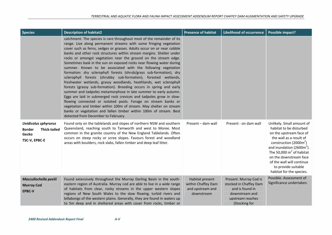
TERRESTRIAL AND AQUATIC FLORA AND FAUNA IMPACT ASSESSMENT ADDENDUM REPORT CHAFFEY DAM AUGMENTATION AND SAFETY UPGRADE
2400 Revised Addendum Report Final A-V
Species Description of habitat2 Presence of habitat Likelihood of occurrence Possible impact?
catchment. The species is rare throughout most of the remainder of its
range. Live along permanent streams with some fringing vegetation
cover such as ferns, sedges or grasses. Adults occur on or near cobble
banks and other rock structures within stream margins. Shelter under
rocks or amongst vegetation near the ground on the stream edge.
Sometimes bask in the sun on exposed rocks near flowing water during
summer. Known to be associated with the following vegetation
formation: dry sclerophyll forests (shrub/grass sub-formation), dry
sclerophyll forests (shrubby sub-formation), forested wetlands,
freshwater wetlands, grassy woodlands, heathlands, wet sclerophyll
forests (grassy sub-formation). Breeding occurs in spring and early
summer and tadpoles metamorphose in late summer to early autumn.
Eggs are laid in submerged rock crevices and tadpoles grow in slow-
flowing connected or isolated pools. Forage on stream banks or
vegetation and timber within 100m of stream. May shelter on stream
banks or vegetation and fallen timber within 100m of stream. Best
detected from December to February.
Uvidicolus sphyrurus
Border Thick-tailed
Gecko
TSC-V, EPBC-E
Found only on the tablelands and slopes of northern NSW and southern
Queensland, reaching south to Tamworth and west to Moree. Most
common in the granite country of the New England Tablelands. Often
occurs on steep rocky or scree slopes. Favours forest and woodland
areas with boulders, rock slabs, fallen timber and deep leaf litter.
Present – dam wall Present - on dam wall Unlikely. Small amount of
habitat to be disturbed
on the upstream face of
the wall as a result of
construction (2000m2)
and inundation (2600m2).
The 50,000 m2 of habitat
on the downstream face
of the wall will continue
to provide suitable
habitat for the species.
Maccullochella peelii
Murray Cod
EPBC-V
Found extensively throughout the Murray Darling Basin in the south-
eastern region of Australia. Murray cod are able to live in a wide range
of habitats from clear, rocky streams in the upper western slopes
regions of New South Wales to the slow flowing, turbid rivers and
billabongs of the western plains. Generally, they are found in waters up
to 5m deep and in sheltered areas with cover from rocks, timber or
Habitat present
within Chaffey Dam
and upstream and
downstream
Present. Murray Cod is
stocked in Chaffey Dam
and is found in
downstream and
upstream reaches
(Stocking for
Possible. Assessment of
Significance undertaken.
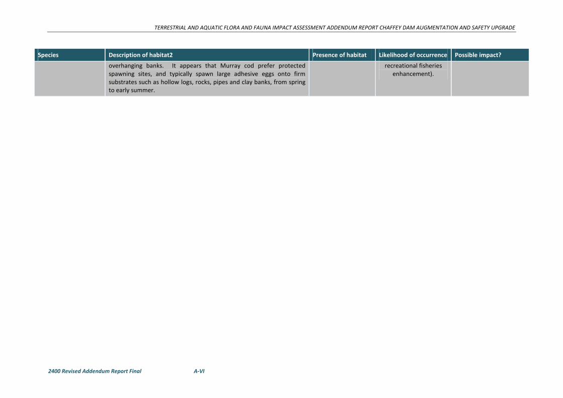
TERRESTRIAL AND AQUATIC FLORA AND FAUNA IMPACT ASSESSMENT ADDENDUM REPORT CHAFFEY DAM AUGMENTATION AND SAFETY UPGRADE
2400 Revised Addendum Report Final A-VI
Species Description of habitat2 Presence of habitat Likelihood of occurrence Possible impact?
overhanging banks. It appears that Murray cod prefer protected
spawning sites, and typically spawn large adhesive eggs onto firm
substrates such as hollow logs, rocks, pipes and clay banks, from spring
to early summer.
recreational fisheries
enhancement).
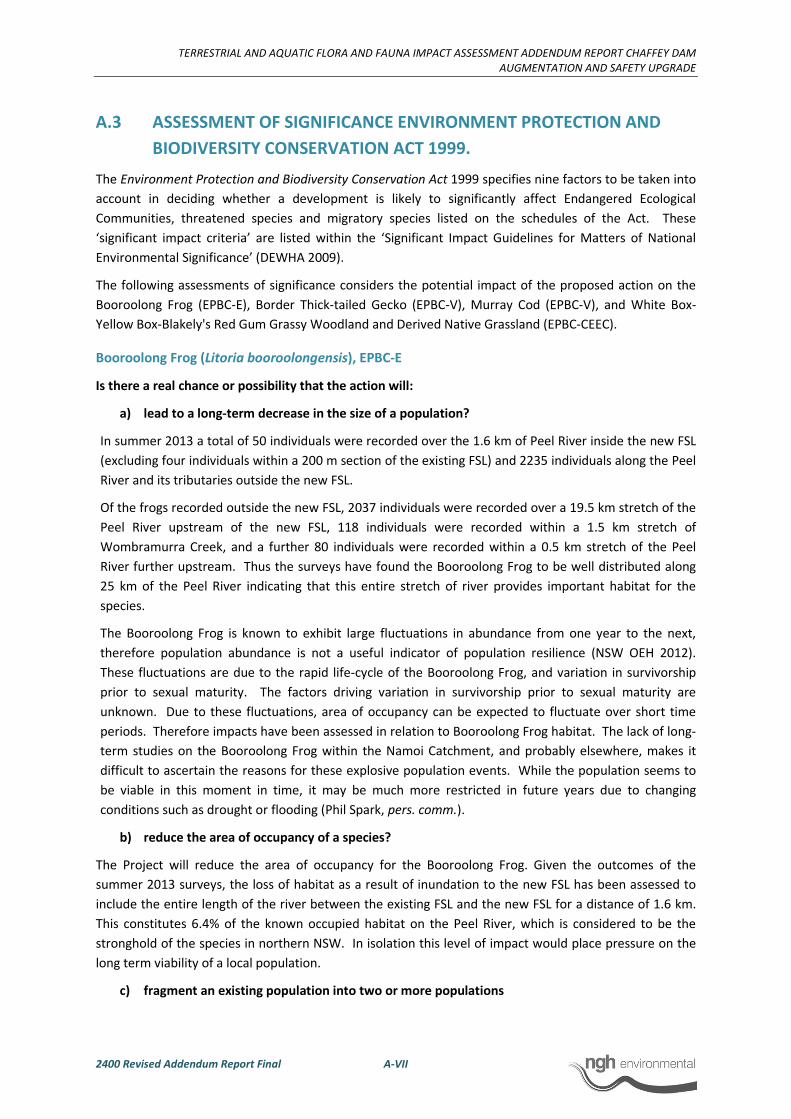
TERRESTRIAL AND AQUATIC FLORA AND FAUNA IMPACT ASSESSMENT ADDENDUM REPORT CHAFFEY DAM
AUGMENTATION AND SAFETY UPGRADE
2400 Revised Addendum Report Final A-VII
A.3 ASSESSMENT OF SIGNIFICANCE ENVIRONMENT PROTECTION AND
BIODIVERSITY CONSERVATION ACT 1999.
The Environment Protection and Biodiversity Conservation Act 1999 specifies nine factors to be taken into
account in deciding whether a development is likely to significantly affect Endangered Ecological
Communities, threatened species and migratory species listed on the schedules of the Act. These
‘significant impact criteria’ are listed within the ‘Significant Impact Guidelines for Matters of National
Environmental Significance’ (DEWHA 2009).
The following assessments of significance considers the potential impact of the proposed action on the
Booroolong Frog (EPBC-E), Border Thick-tailed Gecko (EPBC-V), Murray Cod (EPBC-V), and White Box-
Yellow Box-Blakely's Red Gum Grassy Woodland and Derived Native Grassland (EPBC-CEEC).
Booroolong Frog (Litoria booroolongensis), EPBC-E
Is there a real chance or possibility that the action will:
a) lead to a long-term decrease in the size of a population?
In summer 2013 a total of 50 individuals were recorded over the 1.6 km of Peel River inside the new FSL
(excluding four individuals within a 200 m section of the existing FSL) and 2235 individuals along the Peel
River and its tributaries outside the new FSL.
Of the frogs recorded outside the new FSL, 2037 individuals were recorded over a 19.5 km stretch of the
Peel River upstream of the new FSL, 118 individuals were recorded within a 1.5 km stretch of
Wombramurra Creek, and a further 80 individuals were recorded within a 0.5 km stretch of the Peel
River further upstream. Thus the surveys have found the Booroolong Frog to be well distributed along
25 km of the Peel River indicating that this entire stretch of river provides important habitat for the
species.
The Booroolong Frog is known to exhibit large fluctuations in abundance from one year to the next,
therefore population abundance is not a useful indicator of population resilience (NSW OEH 2012).
These fluctuations are due to the rapid life-cycle of the Booroolong Frog, and variation in survivorship
prior to sexual maturity. The factors driving variation in survivorship prior to sexual maturity are
unknown. Due to these fluctuations, area of occupancy can be expected to fluctuate over short time
periods. Therefore impacts have been assessed in relation to Booroolong Frog habitat. The lack of long-
term studies on the Booroolong Frog within the Namoi Catchment, and probably elsewhere, makes it
difficult to ascertain the reasons for these explosive population events. While the population seems to
be viable in this moment in time, it may be much more restricted in future years due to changing
conditions such as drought or flooding (Phil Spark, pers. comm.).
b) reduce the area of occupancy of a species?
The Project will reduce the area of occupancy for the Booroolong Frog. Given the outcomes of the
summer 2013 surveys, the loss of habitat as a result of inundation to the new FSL has been assessed to
include the entire length of the river between the existing FSL and the new FSL for a distance of 1.6 km.
This constitutes 6.4% of the known occupied habitat on the Peel River, which is considered to be the
stronghold of the species in northern NSW. In isolation this level of impact would place pressure on the
long term viability of a local population.
c) fragment an existing population into two or more populations
TERRESTRIAL AND AQUATIC FLORA AND FAUNA IMPACT ASSESSMENT ADDENDUM REPORT CHAFFEY DAM
AUGMENTATION AND SAFETY UPGRADE
2400 Revised Addendum Report Final A-VIII
The Project will not fragment an existing population into two or more populations. The area of
inundation is at the southernmost point of Chaffey Dam. There is unsuitable habitat available for the
Booroolong Frog at Chaffey Dam, and there are no recent records for the Booroolong Frog downstream
of the dam.
d) adversely affect habitat critical to the survival of a species?
The National Recovery Plan for Booroolong Frog (OEH 2012) states that “habitat critical to the survival of
the Booroolong Frog is rocky sections of permanent streams occupied by the species. Any action that
reduces stream permanency (e.g. pumping water) or results in loss of rock crevices (e.g. smothering by
weeds or sedimentation), is likely to threaten the persistence of local populations of this species.” The
area of river that will be inundated as a result of the Project contains habitat critical to the survival of the
Booroolong Frog. The habitat equates to 6.4 % of the total known habitat along the Peel River,
immediately upstream of Chaffey Dam.
e) disrupt the breeding cycle of a population?
It is unknown to what extent the project will disrupt the breeding cycle of the Booroolong Frog within the
impact area. Breeding is known to occur in spring and early summer, from October through to early
January. The species uses a range of habitats at different life stages, with tadpoles developing in slow-
flowing connected or isolated pools (Anstis 2002). Tadpoles take 2-4 months to develop,
metamorphosing in late summer to early autumn (NSW OEH 2012; Anstis 2002). It is therefore evident
that the Booroolong Frog has a reliance on both riffle and pool habitats, which are the features that
comprise the surveyed sections of the Peel River. The loss of habitat for the Booroolong Frog as a result
of the Project will also reduce the extent of breeding habitat for this species.
f) modify, destroy, remove, isolate or decrease the availability or quality of habitat to the
extent that the species is likely to decline?
The Project will result in the effective removal of 1.6 km of known habitat for the Booroolong Frog. Not
enough is currently known about this species, therefore the impacts of the Project on the population of
the Booroolong Frog along the Peel River cannot be fully understood. The site to be inundated is
historically known as a high density location, probably due to floods in 2008. Suitable habitat is a limiting
factor for the persistence of the Booroolong Frog, therefore the removal of 6.4% of habitat of the local
population is deemed to contribute to the decline of the species.
g) result in invasive species that are harmful to a critically endangered or endangered
species becoming established in the endangered or critically endangered species’
habitat?
The Project will not result in the establishment of invasive species in the habitat of the Booroolong Frog,
either within the impact area or further upstream. Threats from invasive species such as predatory fish
and foxes already exist, and will not be exacerbated by the Project.
h) introduce disease that may cause the species to decline?
The Project will not increase the impact of infection with the amphibian chytrid fungus on the
Booroolong Frog population along the Peel River. Chytrid fungus is already a known threat in the area,
and will not be amplified by the Project.
i) interfere with the recovery of the species?
The National Recovery Plan for Booroolong Frog Litoria booroolongensis identifies eight overall objectives
each with a number of priority actions within it (NSW OEH 2012). The overall objective of recovery is to

TERRESTRIAL AND AQUATIC FLORA AND FAUNA IMPACT ASSESSMENT ADDENDUM REPORT CHAFFEY DAM
AUGMENTATION AND SAFETY UPGRADE
2400 Revised Addendum Report Final A-IX
minimise the probability of extinction of the Booroolong Frog in the wild, and to increase the probability
of populations becoming self-sustaining and viable in the longer term.
Recovery Plan
Objective
Recovery Plan Objective details State Water response
1 Determine the species distribution in areas
that have not been the focus of targeted
surveys.
State Water and Namoi CMA funded the
summer 2013 surveys along the Peel River,
which has increased our understanding of
the present status and distribution of the
Booroolong Frog along 25 km of the Peel
River. A management plan will be
developed and implemented by State
Water for the Booroolong Frog population
on the Peel River that will include
provision for post-construction monitoring
for a period of 2 years to monitor the
impacts of the Project on the population
both within and outside the new FSL.
3 Reduce the impact of known or perceived
threats contributing to the ongoing decline
of the Booroolong Frog.
The management plan to be developed
and implemented by State Water for the
Booroolong Frog population on the Peel
River will include provision for an Offset
Plan which includes remediation and
threat mitigation as required at offset sites
(e.g. stock exclusion, weed removal,
restoration of the riparian zone).
4 Determine population trends across the
species range, and in areas subject to
different management regimes.
Post-construction monitoring will detect
changes in populations both within and
outside of the new FSL, and relate those
changes to specific habitat features and
the presence/absence of threats at
recorded locations.
6 Identify other potentially threatening
processes.
Post-construction monitoring will record
the presence/absence of Chytridiomycosis
within the population
Post-construction monitoring will also
allow for the detection and quantification
of other threatening processes presently
unknown that may be contributing to the
decline of the species.
7 Increase community awareness and
involvement in the Booroolong Frog
recovery program.
State Water to consider future possibilities
for raising community awareness and
collaborative work with Namoi CMA.
8 Achieve the effective implementation of
the recovery plan.
All of the actions above will contribute to
effectively implementing the objectives of
the recovery plan.
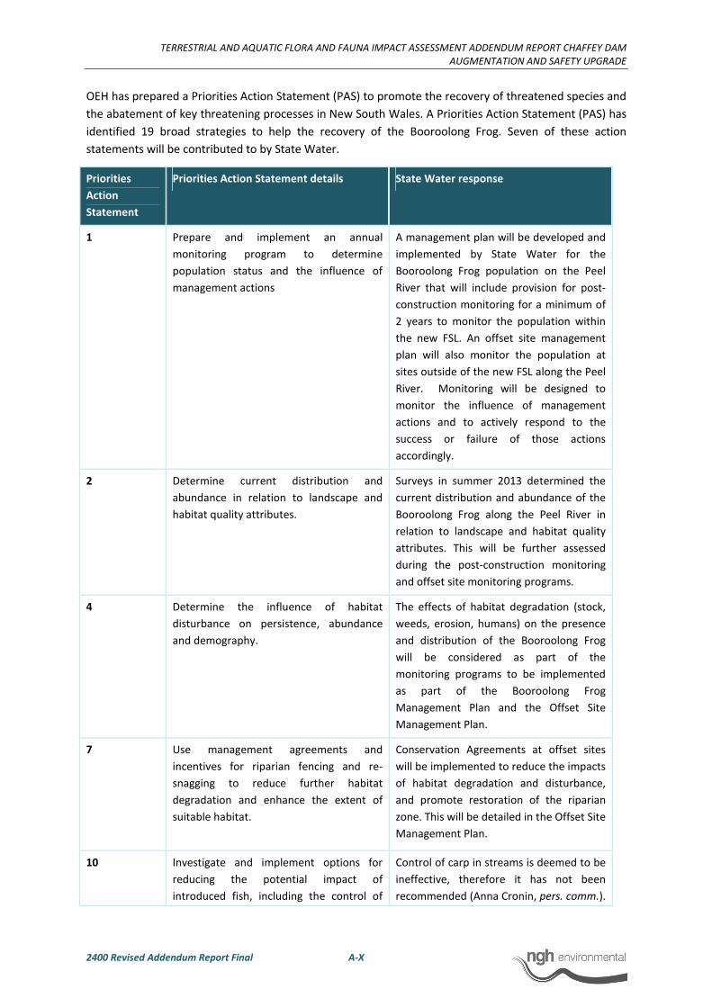
TERRESTRIAL AND AQUATIC FLORA AND FAUNA IMPACT ASSESSMENT ADDENDUM REPORT CHAFFEY DAM
AUGMENTATION AND SAFETY UPGRADE
2400 Revised Addendum Report Final A-X
OEH has prepared a Priorities Action Statement (PAS) to promote the recovery of threatened species and
the abatement of key threatening processes in New South Wales. A Priorities Action Statement (PAS) has
identified 19 broad strategies to help the recovery of the Booroolong Frog. Seven of these action
statements will be contributed to by State Water.
Priorities
Action
Statement
Priorities Action Statement details State Water response
1 Prepare and implement an annual
monitoring program to determine
population status and the influence of
management actions
A management plan will be developed and
implemented by State Water for the
Booroolong Frog population on the Peel
River that will include provision for post-
construction monitoring for a minimum of
2 years to monitor the population within
the new FSL. An offset site management
plan will also monitor the population at
sites outside of the new FSL along the Peel
River. Monitoring will be designed to
monitor the influence of management
actions and to actively respond to the
success or failure of those actions
accordingly.
2 Determine current distribution and
abundance in relation to landscape and
habitat quality attributes.
Surveys in summer 2013 determined the
current distribution and abundance of the
Booroolong Frog along the Peel River in
relation to landscape and habitat quality
attributes. This will be further assessed
during the post-construction monitoring
and offset site monitoring programs.
4 Determine the influence of habitat
disturbance on persistence, abundance
and demography.
The effects of habitat degradation (stock,
weeds, erosion, humans) on the presence
and distribution of the Booroolong Frog
will be considered as part of the
monitoring programs to be implemented
as part of the Booroolong Frog
Management Plan and the Offset Site
Management Plan.
7 Use management agreements and
incentives for riparian fencing and re-
snagging to reduce further habitat
degradation and enhance the extent of
suitable habitat.
Conservation Agreements at offset sites
will be implemented to reduce the impacts
of habitat degradation and disturbance,
and promote restoration of the riparian
zone. This will be detailed in the Offset Site
Management Plan.
10 Investigate and implement options for
reducing the potential impact of
introduced fish, including the control of
Control of carp in streams is deemed to be
ineffective, therefore it has not been
recommended (Anna Cronin, pers. comm.).
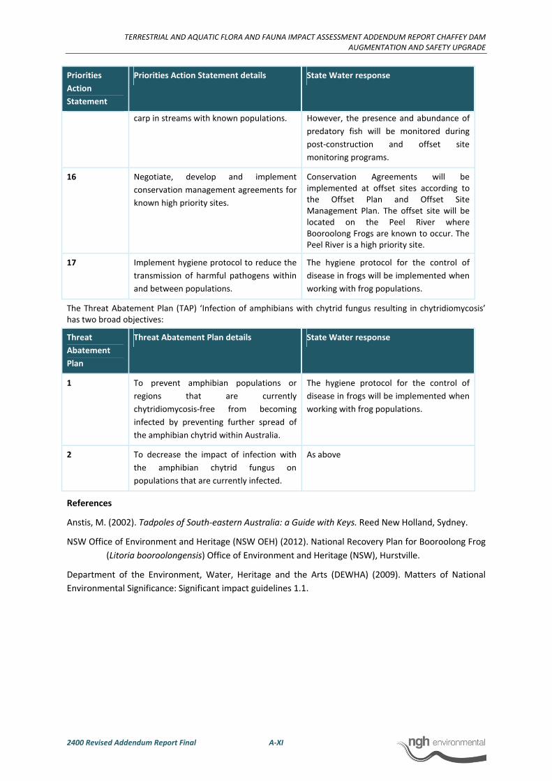
TERRESTRIAL AND AQUATIC FLORA AND FAUNA IMPACT ASSESSMENT ADDENDUM REPORT CHAFFEY DAM
AUGMENTATION AND SAFETY UPGRADE
2400 Revised Addendum Report Final A-XI
Priorities
Action
Statement
Priorities Action Statement details State Water response
carp in streams with known populations.
However, the presence and abundance of
predatory fish will be monitored during
post-construction and offset site
monitoring programs.
16 Negotiate, develop and implement
conservation management agreements for
known high priority sites.
Conservation Agreements will be
implemented at offset sites according to
the Offset Plan and Offset Site
Management Plan. The offset site will be
located on the Peel River where
Booroolong Frogs are known to occur. The
Peel River is a high priority site.
17 Implement hygiene protocol to reduce the
transmission of harmful pathogens within
and between populations.
The hygiene protocol for the control of
disease in frogs will be implemented when
working with frog populations.
The Threat Abatement Plan (TAP) ‘Infection of amphibians with chytrid fungus resulting in chytridiomycosis’
has two broad objectives:
Threat
Abatement
Plan
Threat Abatement Plan details State Water response
1 To prevent amphibian populations or
regions that are currently
chytridiomycosis-free from becoming
infected by preventing further spread of
the amphibian chytrid within Australia.
The hygiene protocol for the control of
disease in frogs will be implemented when
working with frog populations.
2 To decrease the impact of infection with
the amphibian chytrid fungus on
populations that are currently infected.
As above
References
Anstis, M. (2002). Tadpoles of South-eastern Australia: a Guide with Keys. Reed New Holland, Sydney.
NSW Office of Environment and Heritage (NSW OEH) (2012). National Recovery Plan for Booroolong Frog
(Litoria booroolongensis) Office of Environment and Heritage (NSW), Hurstville.
Department of the Environment, Water, Heritage and the Arts (DEWHA) (2009). Matters of National
Environmental Significance: Significant impact guidelines 1.1.

TERRESTRIAL AND AQUATIC FLORA AND FAUNA IMPACT ASSESSMENT ADDENDUM REPORT CHAFFEY DAM
AUGMENTATION AND SAFETY UPGRADE
2400 Revised Addendum Report Final A-XII
Border Thick-tailed Gecko (EPBC-V)
Is there a real chance or possibility that the action will:
a) lead to a long-term decrease in the size of an important population of a species?
Individuals of this species have been recorded on the Chaffey Dam wall. Border Thick-tailed Geckos have
been recorded frequently throughout the Nandewar bioregion, and the species was considered for
delisting in 2008. However, due to the increasing threat that Coolatai grass is having on its habitat
throughout the Nandewar bioregion, it was retained as a vulnerable species.
NWES (2009a) found the Border Thick-tailed Gecko to be relatively common within the region, and
recorded it many times in shrubby rocky remnants around Woolomin, including Goat Mountain, to the
immediate northwest of the dam wall. The Border Thick-tailed Gecko individuals present on the dam
wall are likely to be part of a much larger population that occupies a large remnant of approximately 100
ha of suitable habitat (NWES, 2009a). Surveys in October 2012 confirmed the presence of this species on
the Dam wall (three individuals). One individual was also recorded on Goat Mountain where there is
abundant habitat available for this species. A planted corridor was created in late 2011 and early 2012
with the aim of linking Goat Mountain with the Peel River and habitat areas to the east. This corridor in
its current state of growth is not suitable as a wildlife corridor, but may facilitate movement of Border
Thick-tailed Geckos between Goat Mountain and the dam wall in the future. The rock used for raising of
the dam wall will be consistent with that currently inhabited by the species on the wall.
With the revised construction methodology there has been a dramatic reduction in the level of impact to
the Border Thick-tailed Geckos inhabiting the dam wall. The raising of the morning glory spillway access
bridge and platform on the piers, and changes to the auxiliary spillway and fuse plug will no longer
proceed as part of the proposed works. As an alternative, a vertical reinforced earth embankment for
wall raising will be constructed on the crest of the dam wall (Figure 2-6). As a result, the 50,000 m2 of
Border Thick-tailed Gecko habitat on the downstream face of the wall will no longer be impacted.
Impacts associated with the revised construction methodology will only occur on the crest of the dam
wall during construction of the vertical wall, and along the upstream face of the wall between the left
bank and the morning glory spillway. This constitutes a total impact area of 2,000 m2 where some
individuals on the upstream face of the dam wall may be impacted by construction. The Border Thick-
tailed Geckos on the dam wall have not been identified as an important population. Construction
associated with the raising of the dam wall has been designed to avoid impacts to those individuals that
may be impacted. Provided that the proposed mitigation measures are carried out, the Project is unlikely
to lead to a long-term decrease in the size of the population that inhabits the dam wall. The loss of some
individuals within the impact zone may be unavoidable, however the mitigation measures proposed aim
to reduce those impacts. No natural habitat for the species will be removed. An area of artificial habitat
on the dam wall will be removed and replaced. Furthermore, this species is unlikely to be significantly
impacted by the increased FSL.
b) reduce the area of occupancy of an important population?
The Border Thick-tailed Gecko population on the dam wall has not been identified as an important
population.
The crest of the existing dam wall will be raised by 6.5 m to 525.1 m AHD, and the proposed works may
impact on habitat utilised by some individuals on the upstream face of the dam wall. As a result, there
may be a temporary reduction of the area of occupancy during construction, however mitigation
measures have been designed to prevent impacts to those individuals, and will allow geckos to continue
TERRESTRIAL AND AQUATIC FLORA AND FAUNA IMPACT ASSESSMENT ADDENDUM REPORT CHAFFEY DAM
AUGMENTATION AND SAFETY UPGRADE
2400 Revised Addendum Report Final A-XIII
inhabiting the remainder of the dam wall during construction. The impact area (2000 m2) constitutes a
very small area of known Border Thick-tailed Gecko habitat (56,000 m2) on the dam wall. Pre-clearance
surveys will also be undertaken to minimise impacts to Border Thick-tailed Geckos within the impact
area. Overall, at the completion of construction additional habitat will be available for the Border Thick-
tailed Gecko through the raising of the dam wall.
Known habitat for the Border Thick-tailed Gecko exists on Goat Mountain, to the north-west of the dam
wall, and will not be impacted by the Project.
c) fragment an existing important population into two or more populations?
The Border Thick-tailed Gecko population on the dam wall has not been identified as an important
population. The area of Border Thick-tailed Gecko habitat on the dam wall that will be impacted by
construction will not become further fragmented or isolated as a result of the Project, and will ultimately
provide the species with additional habitat as a result of raising the dam wall. The Project will not
permanently fragment an existing population into two or more populations.
d) adversely affect habitat critical to the survival of a species?
No areas of critical habitat have been declared for this species. The habitat to be impacted by the
Project is artificial, but it is evident that the dam wall provides habitat suitable for the species. However,
impacts to the upstream face of the dam wall will be temporary and the species will be able to continue
to use this area of habitat post-construction.
e) disrupt the breeding cycle of an important population?
The Border Thick-tailed Gecko population on the dam wall has not been identified as an important
population. However, little is known of the breeding cycle of this species. They breed during their period
of activity (between September and April), and are likely to produce multiple clutches over the breeding
season. Construction activities within an area of approximately 2000 m2 are unlikely to disrupt the
breeding cycle of the Border Thick-tailed Gecko population on the dam wall, which encompasses a
potential area of 56,000 m2. The breeding cycle of the population on Goat Mountain would not be
disrupted.
f) modify, destroy, remove or isolate or decrease the availability or quality of habitat to
the extent that the species is likely to decline?
During construction, approximately 2000 m2 of habitat on the downstream face of the dam wall will be
modified, temporarily reducing the availability of habitat for some individuals on the dam wall. However,
the remaining 50,000m2 of habitat on the dam wall will not be impacted and will continue to provide
suitable habitat for the population inhabiting the dam wall. Mitigation measures, including pre-clearing
surveys, have been proposed to alleviate risks associated with construction. Overall, the Project will not
decrease the availability or quality of habitat to the extent that the species is likely to decline.
g) result in invasive species that are harmful to a vulnerable species becoming established
in the vulnerable species’ habitat
Coolatai grass is common in the locality (but not on the dam wall), and is listed as a key threatening
process for the Border Thick-tailed Gecko. The dam wall is not currently threatened by this invasive
species, and the Project is unlikely to result in the establishment of it on the wall due to the wall being an
artificial habitat. Safeguards have been proposed that will ensure weeds are adequately controlled at the
site, and a Vegetation Management Plan will be prepared for the Project, thereby improving habitat
available for the Border Thick-tailed Gecko in the study area.

TERRESTRIAL AND AQUATIC FLORA AND FAUNA IMPACT ASSESSMENT ADDENDUM REPORT CHAFFEY DAM
AUGMENTATION AND SAFETY UPGRADE
2400 Revised Addendum Report Final A-XIV
h) introduce disease that may cause the species to decline?
The Project is unlikely to introduce disease that may cause the species to decline.
i) interfere substantially with the recovery of the species?
Recovery and threat abatement plans have not been prepared for the Border Thick-tailed Gecko.
However a Priorities Action Statement (PAS) has identified 15 broad strategies to help the recovery of the
Border Thick-tailed Gecko. State Water intend to respond to 13 of these.
Recovery Plan
Objective
Recovery Plan Objective details State Water response
1 Control and monitor feral and domestic
ungulate disturbance in known and
potential habitat. .
As part of the stock management plan
stock will be prevented from entering the
wildlife corridor area, and habitat between
dam wall and goat mountain. Goat
Mountain, a known location for the
species, will be offset as part of the Offset
Plan and will also be subject to a stock
management plan
2 Control feral cat and fox populations in
areas where key populations of the species
is known to occur.
Fox baiting will be undertaken as part of
the Fauna Management Plan. This action
will benefit a range of species including but
not limited to the Border Thick-tailed
Gecko.
3 Provide map of known occurrences to
Rural Fire Service and seek inclusion of
mitigative measures on Bush Fire Risk
Management Plan(s), risk register and/or
operation map(s).
State Water will provide a map of known
occurrences to Rural Fire Service.
4 Ensure logging waste in forest or
woodland is not stock-piled or burnt
where the species occurs.
As part of the offset site, Goat Mountain
will not be at risk from logging, stockpiling
or fire.
5 Encourage the retention of dead fallen
timber in areas where the species is known
to occur. .
As part of the offset site, fallen timber on
Goat Mountain will be retained.
6 Provide fire wood in areas where
recreational use overlaps with species
habitat to preserve large fallen logs and
groundcover vegetation. .
Signage will be implemented to prevent
fire wood collection in areas where
recreational use and Border Thick-tailed
Gecko habitat may overlap, particularly at
the Bowlo Fishing Club.
7 Retain and protect areas of rocky dry open
forest and woodland from clearing,
fragmentation and disturbance.
As part of the offset site, Goat Mountain
will not be at risk from clearing,
fragmentation or disturbance.
8 Retain bushrock in its natural setting
within the species range and encourage
rocks be obtained for gardens only from
licensed dealers.
As part of the offset site, Goat Mountain
will not be at high risk from bushrock
collection. Signage will be incorporated at
the Bowlo Fishing Club where there may
be a small risk.
9 Develop and implement firewood
collection policies to ensure large logs and
woody debris are not removed from
Signage will be implemented to prevent
fire wood collection in areas where
recreational use and Border Thick-tailed

TERRESTRIAL AND AQUATIC FLORA AND FAUNA IMPACT ASSESSMENT ADDENDUM REPORT CHAFFEY DAM
AUGMENTATION AND SAFETY UPGRADE
2400 Revised Addendum Report Final A-XV
Recovery Plan
Objective
Recovery Plan Objective details State Water response
Border Thick-tailed Gecko habitat. Gecko habitat may overlap, particularly at
the Bowlo Fishing Club.
10 Identify locations supporting key
populations.
Goat Mountain has been identified as a
key area.
11 Determine site specific management
strategies to protect and enhance key
populations.
Weed management would be ongoing as
per the Vegetation Management Plan
particularly focusing on Coolatai Grass
infested areas around the dam wall and
planted wildlife corridor.
12 Identify sites in key habitats and corridors
for vegetation rehabilitation and
undertake revegetation to provide links
between key populations.
A planted corridor was established in late
2011 and early 2012 in order to maintain
connectivity from the dam wall to Goat
Mountain. Once established, it is likely this
will provide habitat for a range of native
species protected under both State and
Commonwealth legislation, particularly the
Border Thick-tailed Gecko.
15 Control and monitor weed invasion within
known and potential habitat. .
Weed management would be ongoing as
per the Vegetation Management Plan
particularly focusing on Coolatai Grass
infested areas around the dam wall and
planted wildlife corridor.
Overall, the Project will not interfere with the recovery of the Border Thick-tailed Gecko in the long-term.
A very small amount of artificial habitat will be impacted, with no predicted impact to the geckos.
Mitigation measures have been designed to minimise impacts to the species during construction.

TERRESTRIAL AND AQUATIC FLORA AND FAUNA IMPACT ASSESSMENT ADDENDUM REPORT CHAFFEY DAM
AUGMENTATION AND SAFETY UPGRADE
2400 Revised Addendum Report Final A-XVI
Murray Cod (EPBC-V)
Is there a real chance or possibility that the action will:
a) lead to a long-term decrease in the size of an important population of a species?
Not applicable. The Murray Cod population in the Peel River is not identified as an important population
in a recovery plan. The Murray Cod population is stocked in Chaffey Dam and the Peel River downstream
of the dam. The Murray Cod population is not considered to fit the definition of an important population
under the EPBC Act Significant impact guidelines 1.1 (refer to Section 2.4).
b) reduce the area of occupancy of an important population?
Not applicable. The Murray Cod population in the Peel River is not identified as an important population
in a recovery plan. The Murray Cod population is stocked in Chaffey Dam and the Peel River downstream
of the dam. The Murray Cod population is not considered to fit the definition of an important population
under the EPBC Act Significant impact guidelines 1.1 (refer to Section 2.4).
c) fragment an existing important population into two or more populations?
Not applicable. The Murray Cod population in the Peel River is not identified as an important population
in a recovery plan. The Murray Cod population is stocked in Chaffey Dam and the Peel River downstream
of the dam. The Murray Cod population is not considered to fit the definition of an important population
under the EPBC Act Significant impact guidelines 1.1 (refer to Section 2.4).
d) adversely affect habitat critical to the survival of a species?
In accordance with the EPBC Act Significant impact guidelines 1.1 definition ‘Habitat critical to the
survival of a species’ refers to areas that are necessary:
• for activities such as foraging, breeding, roosting, or dispersal
• for the long-term maintenance of the species or ecological community (including the
maintenance of species essential to the survival of the species or ecological community,
such as pollinators)
• to maintain genetic diversity and long term evolutionary development, or
• for the reintroduction of populations or recovery of the species or ecological community.
Such habitat may be, but is not limited to habitat identified in a recovery plan for the species as habitat
critical for that species and/ or habitat listed on the Register of Critical Habitat maintained by the minister
under the EPBC Act.
Habitat critical for that species has not been identified in the recovery plan or the register.
As discussed in Section 2.4, the proposed augmentation is unlikely to substantially modify the habitat of
the species and therefore the survival of the species is unlikely to be compromised.
e) disrupt the breeding cycle of an important population?
Not applicable. The Murray Cod population in the Peel River is not identified as an important population
in a recovery plan. The Murray Cod population is stocked in Chaffey Dam and the Peel River downstream
of the dam. The Murray Cod population is not considered to fit the definition of an important population
under the EPBC Act Significant impact guidelines 1.1 (refer to Section 2.4).
f) modify, destroy, remove or isolate or decrease the availability or quality of habitat to
the extent that the species is likely to decline?
TERRESTRIAL AND AQUATIC FLORA AND FAUNA IMPACT ASSESSMENT ADDENDUM REPORT CHAFFEY DAM
AUGMENTATION AND SAFETY UPGRADE
2400 Revised Addendum Report Final A-XVII
Upstream of the dam wall, the filling of the dam, which would occur naturally, to the new full supply level
would flood any fringing aquatic habitat currently present. This loss of habitat is likely to be temporary as
new similar habitat would become available along the new perimeter of the reservoir. Some riparian
vegetation would also be lost along the edges of the reservoir and upstream reaches. The loss of riparian
vegetation may increase bank and channel erosion and temporarily impact water quality (e.g. through
the degradation of riparian vegetation as it progressively floods). The impact would be minor considering
the currently limited availability of riparian habitat around the dam, most likely a result of the existing
fluctuations in the dam water level. While this loss cannot be avoided there are opportunities to
rehabilitate the riparian zone along the new full supply level as part of the proposed works. The
inundation of the riparian zone has the potential to increase the availability of some important aquatic
habitat sources for the Murray Cod such as large woody debris. The raising of the full supply level would
also increase by maximum 185 hectares the area of potential lake habitat but would result in a minor
decrease of riverine habitat (approximately 1% decrease of the total riverine habitat along the Peel River
and its tributaries upstream of the dam). The Murray Cod occurs in both types of environments and the
species is regularly stocked within the impoundment and upstream. As such the potential short term and
long term impacts of the proposal on aquatic habitats are unlikely to be substantial and are unlikely to
result in a decline of the species within the dam or upstream.
Regular stocking of the Murray Cod is undertaken in Chaffey Dam and the Peel River, including
downstream of the dam. The population of the Murray Cod has not been identified as a population under
threat in the recovery plan. Downstream of the dam wall potential impacts as discussed in sections 3 and
4 are unlikely to result in substantial modifications of the habitat of this species such that its extent the
species is likely to decline.
g) result in invasive species that are harmful to a vulnerable species becoming established
in the vulnerable species’ habitat
Exotic fish species, including Carp, Rainbow Trout, Brown Trout, Redfin Perch are known to be established
downstream and upstream of the dam.
Upstream of the dam wall, the raising of the full supply level would increase by maximum 185 hectares
the area of potential lake habitat but would result in a minor decrease of riverine habitat (approximately
1% decrease of the total riverine habitat along the Peel River and its tributaries upstream of the dam).
The additional lake habitat would be available to the Murray Cod but also invasive species.
The natural filling of the dam to the new full supply level would flood any fringing aquatic habitat
currently present. This loss of habitat is likely to be temporary as new similar habitat would become
available along the new perimeter of the reservoir. Some riparian vegetation would also be lost along the
edges of the reservoir and upstream reaches. The loss of riparian vegetation may increase bank and
channel erosion and temporarily impact water quality (e.g. through the degradation of vegetation). The
impact would be minor considering the currently limited availability of riparian habitat around the dam,
most likely a result of the existing fluctuations in the dam water level. While this loss cannot be avoided
there are opportunities to rehabilitate the riparian zone along the new full supply level as part of the
proposed works. The inundation of the riparian zone has the potential to increase the availability of some
important aquatic habitat sources for the Murray Cod such as large woody debris.
Temporary disturbances which may occur during construction or when the dam fills to the new supply
level have the potential to favour exotic species which may be more tolerant to disturbed environments.
However, exotic species are currently established and Murray Cod is regularly stocked in the dam.
TERRESTRIAL AND AQUATIC FLORA AND FAUNA IMPACT ASSESSMENT ADDENDUM REPORT CHAFFEY DAM
AUGMENTATION AND SAFETY UPGRADE
2400 Revised Addendum Report Final A-XVIII
The impact of invasive species on the Murray is not well known. Possible impacts on Murray Cod include
through predation, competition, habitat alteration and spread of diseases and parasites. Carp is a typical
invasive species, which is resilient and well-adapted to exploiting riverine environments that are already
degraded (Koehn et al. 2000; Koehn 2004). At high densities Carp may increase turbidity and reduce
aquatic vegetation through their feeding habits, reducing habitat for native species. As discussed above,
temporary disturbances may favour the Carp, especially in the dam. However, although Carp may
compete with Murray Cod for space, there is no evidence for any other form of competition between
Murray Cod and Carp, and young Carp may provide a source of food for Murray Cod. Despite public
opinion, there is no scientific evidence that increases in Carp have affected Murray Cod numbers (Koehn
et al. 2000). There is however some correlation between high numbers of alien fish, especially Carp and
Redfin Perch, and low numbers of native fish including Murray Cod (Rowland 2005). The recent apparent
increases in cod number in NSW coincide with historically low numbers of Carp and Redfin Perch.
Predation by and competition with Redfin Perch in the 1950s and 1960s may have been a contributing
factor to the decline of Murray Cod in the southern part of MDB during that time (Rowland 2005). Effects
of other species that can reach very high densities are not known.
As discussed in section 3 and 4, downstream impacts are unlikely to substantially alter the habitat of the
Peel River compared to existing conditions. As such, considering invasive species are known to occur
downstream, invasive species are unlikely to become established in new areas.
h) introduce disease that may cause the species to decline?
Very little is known about the prevalence and impact of diseases on Murray Cod. The major concern
probably relates to those exotic diseases introduced to Australia with imported fish which have found
their way into the environment. Diseases and pathogens of potential major concern include the Epizootic
Haematopoietic Necrosis (EHN) virus, Viral Encephalopathy and Retinopathy (VER), Goldfish Ulcer Disease
(GUD), Asian Fish Tapeworm Bothriocephalus acheilognathis and the parasitic copepod Anchorworm
Lernaea cyprinacea. The introduced Redfin Perch carries EHN (Langdon et al. 1986), to which Murray Cod
are highly susceptible (Langdon 1989; Langdon et al. 1986; Langdon et al. 1987; MDBC 2004a). A MDBC
project is currently underway investigating the susceptibility of native fish species to EHN and its
epidemiology in the wild.
A new iridovirus has been detected in cultured Murray Cod in Victoria but has not yet been detected in
wild fish (Prof. Richard Whittington pers. comm.; unpubl. data). The abundance of alien fish such as Carp
and Eastern Gambusia may act as source for introduced pathogens such as Anchorworm and Asian Fish
Tapeworm. Ectoparasitic protozoans including Chilodonella species, Ichthyophthirius species, Myxosoma
species and Trichodina species are widespread and can be problematic in fish culture conditions
(Ashburner 1978; Ashburner and Ehl 1973; Langdon 1989; Langdon et al. 1986; Langdon et al. 1987;
Rowland and Ingram 1991), but their occurrence or impact in the wild is unknown. Chilodonella
infestation has killed adult Trout Cod kept at a hatchery (Ingram and Rimmer 1992) and has been
suggested as a threat to wild populations (Douglas et al. 1994). There is the potential to introduce disease
to wild populations through the release of hatchery-bred fish. All hatcheries breeding Murray Cod need
to comply with the National Policy for the Translocation of Live Aquatic Organisms guidelines (MCFFA
1999), requiring disease screening prior to release.
Exotic fish species, including Carp, are known to occur downstream and upstream of the dam and have
the potential to carry diseases. However, native or exotic fish would not be introduced as part of the
proposal and therefore it is unlikely that the proposal would introduce a disease.

TERRESTRIAL AND AQUATIC FLORA AND FAUNA IMPACT ASSESSMENT ADDENDUM REPORT CHAFFEY DAM
AUGMENTATION AND SAFETY UPGRADE
2400 Revised Addendum Report Final A-XIX
i) interfere substantially with the recovery of the species?
The Murray Cod recovery plan includes a list of priority actions for the recovery of the species. These are:
• Population structure and management
• Determine the distribution, structure and dynamics of Murray Cod populations across the
Murray Darling Basin and devise appropriate Spatial Management Units and monitoring
program.
• Recruitment
• Identify and quantify the environmental parameters (e.g. flows and available food) that
drive recruitment and population growth.
• Habitat use, protection and repair
• Identify, protect and repair key aquatic and riparian habitats for Murray Cod in each
Spatial Management Unit.
• Sustainable take
• Manage the recreational fishery for Murray Cod in a sustainable manner while recognising
the social, economic and recreational value of the fishery.
• Community ownership
• Encourage community awareness and support for Murray Cod management (including
angling and conservation groups).
• Recovery Plan implementation
• Establish a long-term structure for the implementation of the national Murray Cod
Recovery Plan.
The proposal would not interfere with any of the actions outlined in the recovery plan.
Regular stocking of the Murray Cod is undertaken in Chaffey Dam and the Peel River, including
downstream of the dam. The population of the Murray Cod has not been identified as a population under
threat in the recovery plan. As discussed the proposal is unlikely to have a long term impact on the
Murray Cod or its habitat and therefore its recovery is unlikely to be compromised.
Overall, a significant impact to the Murray Cod is unlikely to occur as a result of the proposed
augmentation of Chaffey Dam.
TERRESTRIAL AND AQUATIC FLORA AND FAUNA IMPACT ASSESSMENT ADDENDUM REPORT CHAFFEY DAM
AUGMENTATION AND SAFETY UPGRADE
2400 Revised Addendum Report Final A-XX
White Box-Yellow Box-Blakely's Red Gum Grassy Woodland and Derived Native Grassland
Is there a real chance or possibility that the action will:
a) reduce the extent of an ecological community?
Approximately 10 ha of EPBC-listed White Box-Yellow Box-Blakely's Red Gum Grassy Woodland and
Derived Native Grassland (hereafter called Box-Gum Woodland) is likely to be inundated or be cleared as
a result of the Chaffey Dam safety upgrade and augmentation (the Project). The works are thus going to
effectively clear this extent of the community from the landscape. Field surveys conducted within a 1 km
buffer zone surrounding Chaffey Dam and subsequent GIS mapping indicate that there is approximately
506 ha of Box-Gum Woodland currently present in the area.
b) fragment or increase fragmentation of an ecological community?
Habitat within the study area has already been highly modified and fragmented due to agricultural and
recreational pressures. Habitat for this community is substantially more contiguous above the new FSL in
areas where it currently exists. There is approximately 1300 ha of lower-quality TSC-listed Box-Gum
Woodland that is present in the buffer zone which also assists in the connectivity of the EPBC-listed
community. Considering this, the Project is unlikely to result in any substantial further fragmentation of
Box-Gum Woodland in the region.
c) adversely affect habitat critical to the survival of an ecological community?
A draft National Recovery Plan for Box-Gum Woodland (2010) states that habitat critical to the survival of
Box-Gum Woodland is “on the moderate to highly fertile soils of the western slopes of NSW and
Queensland, the northern slopes of Victoria, and the tablelands of the Great Dividing Range from
southern Queensland through NSW and the ACT”. It also suggests that any areas that meet the minimum
conditional criteria for Box-Gum Woodland should be considered critical to the survival of the
community. Within the area to be affected by the Project, 10 ha of habitat that meets the conditional
criteria will be adversely affected by inundation or vegetation removal.
d) modify or destroy abiotic factors necessary for an ecological community’s survival?
The area surrounding the dam that is to be inundated will have a number of abiotic factors altered. In
essence, there will be increased saturation of the soil by water (raising of the water table) as well as
potential erosion and sedimentation impacts. It is assumed that the changes in abiotic factors that the
area will experience will effectively remove 10 ha of Box-Gum Woodland. However, this is unlikely to
place the local occurrence of the community (506 ha within a 1 km buffer zone that will not be impacted)
at risk of extinction.
e) cause a substantial change in the species composition of an occurrence of an ecological
community?
Impacts resulting from inundation would be likely to substantially change the species composition of the
community within the study area. The removal of all Box-Gum Woodland within the Project boundaries
(10 ha) is expected to occur. The proposed works are unlikely to cause a substantial change in the
species composition of Box-Gum Woodland outside of the Project boundaries (outside the new FSL and
road footprint areas).
f) cause a substantial reduction in the quality or integrity of an occurrence of an ecological
community, including assisting invasive species to become established or causing regular
mobilisation of chemicals or pollutants into the ecological community?
TERRESTRIAL AND AQUATIC FLORA AND FAUNA IMPACT ASSESSMENT ADDENDUM REPORT CHAFFEY DAM
AUGMENTATION AND SAFETY UPGRADE
2400 Revised Addendum Report Final A-XXI
There will be a substantial reduction in the quality or integrity of approximately 10 ha of Box-Gum
Woodland due to the predicted inundation. The Project has the potential to spread weeds such as the
invasive Coolatai Grass (Hyparrhenia hirta) and Blackberry (Rubus fruticosus aggregate) that are already
common in the vicinity of the dam. Many of these species are already established within and near to the
Box-Gum Woodland that surrounds the dam. Safeguards have been proposed that will ensure weeds are
adequately controlled at the site, and a Vegetation Management Plan will be prepared for the Project.
With the appropriate implementation of weed controls during and following construction, weed impacts
of the Project are not expected to be significant.
It is not expected that there will be any regular mobilisation of fertilisers or herbicides or other chemicals
or pollutants into the ecological communities within the buffer zone around the dam that will kill or
inhibit the growth of native species in the ecological community. Weed control will occur during and
after the project, which will likely involve the application of herbicides to exotic species, but this is
unlikely to cause the death or injury of native species in the ecological community.
g) interfere with the recovery of an ecological community?
The recovery of the ecological community within the Project boundaries (10 ha) will be prevented due to
inundation and construction works. The management of the Box-Gum Woodland outside the new full
supply level in perpetuity (roughly estimated to be 75 ha) should ensure that its condition is improved
and the rate of recovery is accelerated. In this sense, there should be a beneficial effect on the recovery
of Box-Gum Woodland outside of the project boundaries as the result of the proposed Offset Plan..
The draft National Recovery Plan for Box-Gum Woodland (2010) identifies seven overall objectives each
with a number of priority actions within it. The specific objective to be achieved is to minimise the risk of
extinction of the ecological community.
Recovery Plan
Objective
Recovery Plan Objective details State Water response
1 Achieving no net loss in extent and
condition of the ecological community
throughout its geographic distribution
The loss of approximately 10 ha of Box-
Gum Woodland within the Project
boundary will be offset by the active
management in perpetuity of the
ecological community in the surrounding
area. The active management of TSC-listed
Box-Gum Woodland outside the boundary
has the potential to considerably increase
the area of the EPBC-listed community in
the region.
3 Increasing protection of sites in good
condition
Depending on the final calculated value of
the area to be offset, it is likely that
between 40 and 75 ha of Box-Gum
Woodland will be protected and actively
managed in perpetuity by State Water, as
well as protecting a larger area of the
lower quality TSC-listed ecological
community.
4 Increasing landscape functionality of the
ecological community through
The Box-Gum Woodland that surrounds
the dam has been degraded as the result

TERRESTRIAL AND AQUATIC FLORA AND FAUNA IMPACT ASSESSMENT ADDENDUM REPORT CHAFFEY DAM
AUGMENTATION AND SAFETY UPGRADE
2400 Revised Addendum Report Final A-XXII
management and restoration of degraded
sites
of moderate to heavy grazing and
recreational activities. With the active
management of both TSC- and EPBC-listed
Box-Gum Woodland around the dam,
including the reduction of stocking rates
and weed management, there should be a
rapid and noticeable increase in the
landscape functionality of the ecological
community.
6 Increasing transitional areas around
remnants and linkages between remnants
The offset site, which already has a much
greater contiguity than the patches within
the immediate vicinity of the dam, will be
managed to benefit the connectivity of
higher quality patches by increasing the
quality of the TSC-listed community that
often surrounds them. In time, it is likely
that the size of the high-quality patches
will expand to encompass the surrounding
lower-quality habitat.
7 Bringing about enduring changes in
participating land manager attitudes and
behaviours towards environmental
protection and sustainable land
management practices to increase extent,
integrity and function of Box-Gum Grassy
Woodland
As much of the offset sites are located on
leasehold land, there will be considerable
landholder involvement in the
management of the Box-Gum Woodland. A
Conservation Agreement is likely to be
established, and a number of management
measures will be suggested. These may
include, but are not limited to, the
exclusion of feral species, weed control,
and the management of stock grazing for
conservation purposes. It is expected that
a number of land managers (for different
leaseholds) will be heavily involved in all of
these aspects.
References
Department of Environment, Climate Change and Water NSW (2010). National Recovery Plan for White
Box - Yellow Box - Blakely’s Red Gum Grassy Woodland and Derived Native Grassland, Draft for
Public Comment. Department of Environment, Climate Change and Water NSW, Sydney.
Department of the Environment, Water, Heritage and the Arts (DEWHA) (2009). Matters of National
Environmental Significance: Significant impact guidelines 1.1.
A.1 T

TERRESTRIAL AND AQUATIC FLORA AND FAUNA IMPACT ASSESSMENT ADDENDUM REPORT CHAFFEY DAM AUGMENTATION AND SAFETY UPGRADE
2400 Revised Addendum Report Final B-I
APPENDIX B RESPONSE TO SUBMISSIONS ON PIR (RECEIVED APRIL 2013)
Documents referred to in this response to submissions are:
1. WorleyParsons (2012) Chaffey Dam Augmentation and Safety Upgrade Environmental Impact Statement State Significant Infrastructure. Report prepared
for State Water.
2. nghenvironmental (2012). Terrestrial and Aquatic Flora and Fauna Impact Assessment. Appendix 8 of WorleyParsons (2012).
3. nghenvironmental (2013a). Terrestrial and Aquatic Flora and Fauna Impact Assessment – Addendum Report.
4. nghenvironmental (2013b). Terrestrial and Aquatic Flora and Fauna Impact Assessment – Revised Addendum Report.
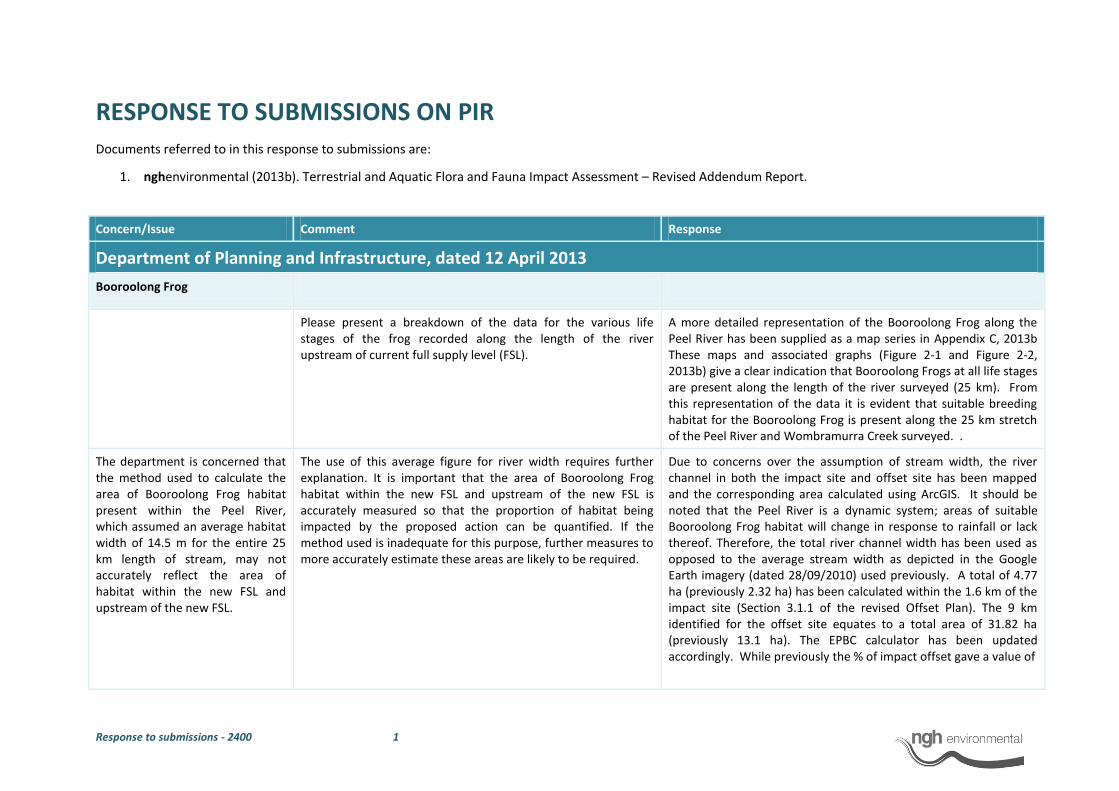
Response to submissions - 2400 1
RESPONSE TO SUBMISSIONS ON PIR
Documents referred to in this response to submissions are:
1. nghenvironmental (2013b). Terrestrial and Aquatic Flora and Fauna Impact Assessment – Revised Addendum Report.
Concern/Issue Comment Response
Department of Planning and Infrastructure, dated 12 April 2013
Booroolong Frog
Please present a breakdown of the data for the various life stages of the frog recorded along the length of the river upstream of current full supply level (FSL).
A more detailed representation of the Booroolong Frog along the Peel River has been supplied as a map series in Appendix C, 2013b These maps and associated graphs (Figure 2-1 and Figure 2-2, 2013b) give a clear indication that Booroolong Frogs at all life stages are present along the length of the river surveyed (25 km). From this representation of the data it is evident that suitable breeding habitat for the Booroolong Frog is present along the 25 km stretch of the Peel River and Wombramurra Creek surveyed. .
The department is concerned that the method used to calculate the area of Booroolong Frog habitat present within the Peel River, which assumed an average habitat width of 14.5 m for the entire 25 km length of stream, may not accurately reflect the area of habitat within the new FSL and upstream of the new FSL.
The use of this average figure for river width requires further explanation. It is important that the area of Booroolong Frog habitat within the new FSL and upstream of the new FSL is accurately measured so that the proportion of habitat being impacted by the proposed action can be quantified. If the method used is inadequate for this purpose, further measures to more accurately estimate these areas are likely to be required.
Due to concerns over the assumption of stream width, the river channel in both the impact site and offset site has been mapped and the corresponding area calculated using ArcGIS. It should be noted that the Peel River is a dynamic system; areas of suitable Booroolong Frog habitat will change in response to rainfall or lack thereof. Therefore, the total river channel width has been used as opposed to the average stream width as depicted in the Google Earth imagery (dated 28/09/2010) used previously. A total of 4.77 ha (previously 2.32 ha) has been calculated within the 1.6 km of the impact site (Section 3.1.1 of the revised Offset Plan). The 9 km identified for the offset site equates to a total area of 31.82 ha (previously 13.1 ha). The EPBC calculator has been updated accordingly. While previously the % of impact offset gave a value of
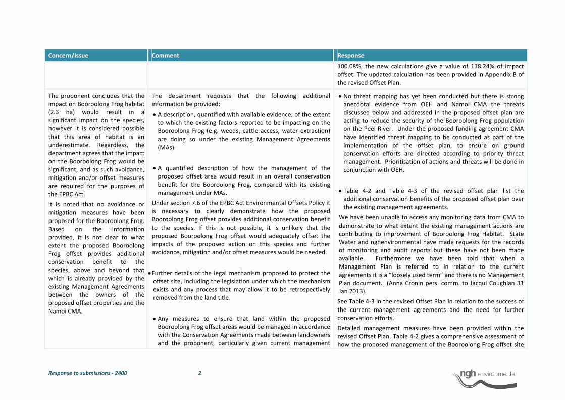
Response to submissions - 2400 2
Concern/Issue Comment Response
100.08%, the new calculations give a value of 118.24% of impact
offset. The updated calculation has been provided in Appendix B of
the revised Offset Plan.
The proponent concludes that the
impact on Booroolong Frog habitat
(2.3 ha) would result in a
significant impact on the species,
however it is considered possible
that this area of habitat is an
underestimate. Regardless, the
department agrees that the impact
on the Booroolong Frog would be
significant, and as such avoidance,
mitigation and/or offset measures
are required for the purposes of
the EPBC Act.
It is noted that no avoidance or
mitigation measures have been
proposed for the Booroolong Frog.
Based on the information
provided, it is not clear to what
extent the proposed Booroolong
Frog offset provides additional
conservation benefit to the
species, above and beyond that
which is already provided by the
existing Management Agreements
between the owners of the
proposed offset properties and the
Namoi CMA.
The department requests that the following additional
information be provided:
• A description, quantified with available evidence, of the extent
to which the existing factors reported to be impacting on the
Booroolong Frog (e.g. weeds, cattle access, water extraction)
are doing so under the existing Management Agreements
(MAs).
• A quantified description of how the management of the
proposed offset area would result in an overall conservation
benefit for the Booroolong Frog, compared with its existing
management under MAs.
Under section 7.6 of the EPBC Act Environmental Offsets Policy it
is necessary to clearly demonstrate how the proposed
Booroolong Frog offset provides additional conservation benefit
to the species. If this is not possible, it is unlikely that the
proposed Booroolong Frog offset would adequately offset the
impacts of the proposed action on this species and further
avoidance, mitigation and/or offset measures would be needed.
• Further details of the legal mechanism proposed to protect the
offset site, including the legislation under which the mechanism
exists and any process that may allow it to be retrospectively
removed from the land title.
• Any measures to ensure that land within the proposed
Booroolong Frog offset areas would be managed in accordance
with the Conservation Agreements made between landowners
and the proponent, particularly given current management
• No threat mapping has yet been conducted but there is strong
anecdotal evidence from OEH and Namoi CMA the threats
discussed below and addressed in the proposed offset plan are
acting to reduce the security of the Booroolong Frog population
on the Peel River. Under the proposed funding agreement CMA
have identified threat mapping to be conducted as part of the
implementation of the offset plan, to ensure on ground
conservation efforts are directed according to priority threat
management. Prioritisation of actions and threats will be done in
conjunction with OEH.
• Table 4-2 and Table 4-3 of the revised offset plan list the
additional conservation benefits of the proposed offset plan over
the existing management agreements.
We have been unable to access any monitoring data from CMA to
demonstrate to what extent the existing management actions are
contributing to improvement of Booroolong Frog Habitat. State
Water and nghenvironmental have made requests for the records
of monitoring and audit reports but these have not been made
available. Furthermore we have been told that when a
Management Plan is referred to in relation to the current
agreements it is a “loosely used term” and there is no Management
Plan document. (Anna Cronin pers. comm. to Jacqui Coughlan 31
Jan 2013).
See Table 4-3 in the revised Offset Plan in relation to the success of
the current management agreements and the need for further
conservation efforts.
Detailed management measures have been provided within the
revised Offset Plan. Table 4-2 gives a comprehensive assessment of
how the proposed management of the Booroolong Frog offset site

Response to submissions - 2400 3
Concern/Issue Comment Response
practices referred to in section 3.2 of the Offset Plan.
• Consideration of the likelihood that the existing MAs between
landowners and Namoi CMA would be renewed after they
expire. It is expected that this assessment could be based on
advice from Namoi CMA.
will result in an overall conservation benefit for the Booroolong
Frog, compared with its existing management under MAs. These
management measures have been proposed in consultation with
David Coote and David Hunter of OEH.
White Box-Yellow Box-Blakely’s Red Gum Grassy Woodland and Derived Native Grassland
The department considers that the
impact of the proposed action on
7.4 ha of the White Box-Yellow
Box-Blakely’s Red Gum Grassy
Woodland and Derived Native
Grassland ecological community
(BGW) would result in a significant
impact on this ecological
community. This is in contrast to
the proponent’s view that this
impact would not be significant.
The department acknowledges the
proponent’s intention to offset this
impact, irrespective of its
conclusion on the significance of
the impact, through the inclusion
of approximately 207 ha of BGW in
the proposed offset area.
However, the information
provided in relation to the
proposed offset is not sufficient to
enable a proper assessment of its
adequacy.
The following additional information is required to inform an
assessment of the proposed BGW offset:
• The area (in hectares) of BGW represented by each of the
three condition classes described in the Commonwealth
Conservation Advice on this ecological community within the
offset area and the impact area.
• Details of the legal mechanism proposed to protect the offset
site, including the legislation under which the mechanism
exists and any process that may allow it to be retrospectively
removed from the land title.
• Further detail on the resources required to support the
• The three condition classes identified in the Conservation Advice
for the community are:
- A eucalypt overstorey but no substantial native
understorey
- A native understorey, but trees have been cleared
- Both a native understorey and a eucalypt overstorey
exist in conjunction
Within the area to be impacted all of the EPBC listed community
(7.38 ha) occurs with both a native understorey and a eucalypt
overstorey. Within the offset site, the majority of the EPBC listed
community occurs in this state (164 ha). Some areas have been
cleared of the eucalypt overstorey and only a native understorey
remains (43 ha). The distribution of these two condition classes
within the proposed offset site is mapped in Appendix D of the
revised Offset Plan.
• A Conservation Agreement is a formal agreement used to protect
and conserve land in perpetuity. The Conservation Agreement is
made between the landholder and the NSW Environment Minister
(through OEH) under the National Parks and Wildlife Act 1974. The
Conservation Agreement is listed on the certificate of title of the
land and is legally binding, meaning that future owners must

Response to submissions - 2400 4
Concern/Issue Comment Response
ongoing management measures and who will be responsible
for implementing them.
• Further explanation on how ongoing cattle grazing would be
consistent with the conservation management of the proposed
offset site.
continue protecting and conserving the land in accordance with the
terms set out in the Conservation Agreement. Penalties will be
enforceable under the National Parks and Wildlife Act for breaches
of the conservation agreements.
• The establishment of Conservation Agreements will ensure the
long-term and effective management and protection of the offset
site. The Conservation Agreements will be registered on the land
title.
• The Conservation Agreement will be lodged with the Department
of Lands and registered on the certificate of land title for the
property. Thus sale of a property would not negate the
compliance obligations of the agreement.
• Breaches of the Conservation Agreements by landholders would
be subject to penalties under the National Parks and Wildlife Act
1974 (see section 69G enforcement of agreements).
• As stated in the Offset Plan (Section 4.2 and Table 4-1), State
Water is the responsible party for the implementation and
monitoring of all management measures at the western offset
site.
• Full details on the resources required to support ongoing
management measures will be included in the Offset Site
Management Plan, to be developed in consultation with OEH.
• Strategic grazing is proposed for the North-West offset site (See
Table 4-1 of the Offset Plan) and an appropriate grazing regime
will be determined by an agronomist and detailed in the north-
west offset site management plan.
Border Thick-tailed Gecko
Based on the information
provided, the magnitude of the
impacts on the Border Thick-tailed
Gecko (BTTG) are unknown and
this must be addressed. In
In order to clarify the likely impacts of the proposed action on
the BTTG, the department requires the following information:
The design of the project has changed so that there will no longer
be any disturbance to the downstream face of the dam wall and
therefore no disturbance or impact to habitat for the Border Thick-
tailed Gecko on the downstream wall. The raising of the morning
glory spillway access bridge and platform on the piers will no longer
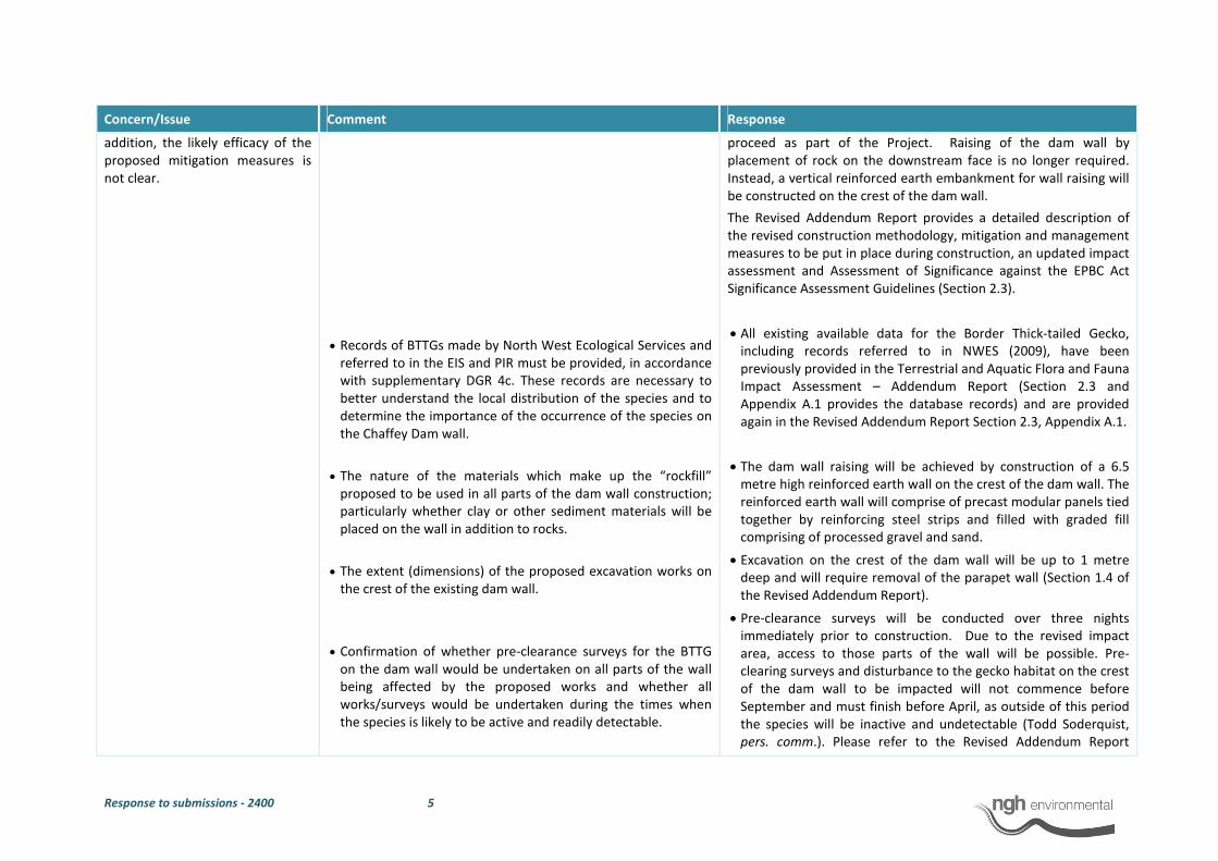
Response to submissions - 2400 5
Concern/Issue Comment Response
addition, the likely efficacy of the
proposed mitigation measures is
not clear.
• Records of BTTGs made by North West Ecological Services and
referred to in the EIS and PIR must be provided, in accordance
with supplementary DGR 4c. These records are necessary to
better understand the local distribution of the species and to
determine the importance of the occurrence of the species on
the Chaffey Dam wall.
• The nature of the materials which make up the “rockfill”
proposed to be used in all parts of the dam wall construction;
particularly whether clay or other sediment materials will be
placed on the wall in addition to rocks.
• The extent (dimensions) of the proposed excavation works on
the crest of the existing dam wall.
• Confirmation of whether pre-clearance surveys for the BTTG
on the dam wall would be undertaken on all parts of the wall
being affected by the proposed works and whether all
works/surveys would be undertaken during the times when
the species is likely to be active and readily detectable.
proceed as part of the Project. Raising of the dam wall by
placement of rock on the downstream face is no longer required.
Instead, a vertical reinforced earth embankment for wall raising will
be constructed on the crest of the dam wall.
The Revised Addendum Report provides a detailed description of
the revised construction methodology, mitigation and management
measures to be put in place during construction, an updated impact
assessment and Assessment of Significance against the EPBC Act
Significance Assessment Guidelines (Section 2.3).
• All existing available data for the Border Thick-tailed Gecko,
including records referred to in NWES (2009), have been
previously provided in the Terrestrial and Aquatic Flora and Fauna
Impact Assessment – Addendum Report (Section 2.3 and
Appendix A.1 provides the database records) and are provided
again in the Revised Addendum Report Section 2.3, Appendix A.1.
• The dam wall raising will be achieved by construction of a 6.5
metre high reinforced earth wall on the crest of the dam wall. The
reinforced earth wall will comprise of precast modular panels tied
together by reinforcing steel strips and filled with graded fill
comprising of processed gravel and sand.
• Excavation on the crest of the dam wall will be up to 1 metre
deep and will require removal of the parapet wall (Section 1.4 of
the Revised Addendum Report).
• Pre-clearance surveys will be conducted over three nights
immediately prior to construction. Due to the revised impact
area, access to those parts of the wall will be possible. Pre-
clearing surveys and disturbance to the gecko habitat on the crest
of the dam wall to be impacted will not commence before
September and must finish before April, as outside of this period
the species will be inactive and undetectable (Todd Soderquist,
pers. comm.). Please refer to the Revised Addendum Report

Response to submissions - 2400 6
Concern/Issue Comment Response
• An assessment of the proportion of the BTTG population
expected to be detected and removed from the dam wall
during pre-clearance surveys for this species, with reference to
survey effort, impact area coverage and timing of surveys.
• An assessment of the likelihood that BTTGs not detected
during pre-clearance surveys could be smothered, crushed or
trapped within the dam wall during construction, and how
Section 2.3 for the revised impact assessment and mitigation and
management measures.
• There is no current abundance data for the dam wall, however
the individuals on the dam wall are likely to be part of the larger
population on Goat Mountain and would represent a small
proportion of that population (NWES 2009). NWES (2009) states
that “The author has found it to be relatively common within the
region, and has recorded it many times in shrubby rocky remnants
around Woolomin, including Goat Mountain”….”The Border Thick-
tailed Gecko is secure in the locality and likely to continue to
recover as large areas of immature regrowth mature to provide
additional areas of suitable habitat” (NWES 2009, pp.24). Of the
available natural habitat (100 ha, NWES 2009), 5.6 ha of artificial
habitat is present on the dam wall. While results of surveys may
indicate that the largest population of Border Thick-tailed Geckos
occurs on the dam wall, this is skewed by probability of detection.
The species is much easier to detect in this homogeneous and
relatively simple environment on the dam wall, compared to its
more complex natural environment (such as that found on Goat
Mountain). Due to the steepness of the wall, access to all parts of
the wall has not been possible. As such, there is no data available
to indicate the abundance or density of the species within this
artificial habitat. Furthermore, without abundance or density
data, an assessment of the proportion of the Border Thick-tailed
Gecko population expected to be detected and removed from the
dam wall during pre-clearance surveys is not possible. However,
due to the revised area of impact, pre-clearance surveys will be
able to detect the species within the entire impact area with
relative ease and relocate individuals to adjacent areas on the
wall that will not be disturbed.
• Considering that population data is unavailable for the Border
Thick-tailed Geckos inhabiting the dam wall, it is not possible to
assess the likelihood that individuals not detected during pre-
clearance surveys could be smothered, crushed or trapped within
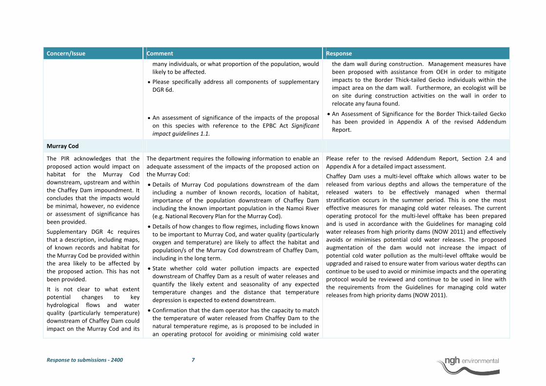
Response to submissions - 2400 7
Concern/Issue Comment Response
many individuals, or what proportion of the population, would
likely to be affected.
• Please specifically address all components of supplementary
DGR 6d.
• An assessment of significance of the impacts of the proposal
on this species with reference to the EPBC Act Significant
impact guidelines 1.1.
the dam wall during construction. Management measures have
been proposed with assistance from OEH in order to mitigate
impacts to the Border Thick-tailed Gecko individuals within the
impact area on the dam wall. Furthermore, an ecologist will be
on site during construction activities on the wall in order to
relocate any fauna found.
• An Assessment of Significance for the Border Thick-tailed Gecko
has been provided in Appendix A of the revised Addendum
Report.
Murray Cod
The PIR acknowledges that the
proposed action would impact on
habitat for the Murray Cod
downstream, upstream and within
the Chaffey Dam impoundment. It
concludes that the impacts would
be minimal, however, no evidence
or assessment of significance has
been provided.
Supplementary DGR 4c requires
that a description, including maps,
of known records and habitat for
the Murray Cod be provided within
the area likely to be affected by
the proposed action. This has not
been provided.
It is not clear to what extent
potential changes to key
hydrological flows and water
quality (particularly temperature)
downstream of Chaffey Dam could
impact on the Murray Cod and its
The department requires the following information to enable an
adequate assessment of the impacts of the proposed action on
the Murray Cod:
• Details of Murray Cod populations downstream of the dam
including a number of known records, location of habitat,
importance of the population downstream of Chaffey Dam
including the known important population in the Namoi River
(e.g. National Recovery Plan for the Murray Cod).
• Details of how changes to flow regimes, including flows known
to be important to Murray Cod, and water quality (particularly
oxygen and temperature) are likely to affect the habitat and
population/s of the Murray Cod downstream of Chaffey Dam,
including in the long term.
• State whether cold water pollution impacts are expected
downstream of Chaffey Dam as a result of water releases and
quantify the likely extent and seasonality of any expected
temperature changes and the distance that temperature
depression is expected to extend downstream.
• Confirmation that the dam operator has the capacity to match
the temperature of water released from Chaffey Dam to the
natural temperature regime, as is proposed to be included in
an operating protocol for avoiding or minimising cold water
Please refer to the revised Addendum Report, Section 2.4 and
Appendix A for a detailed impact assessment.
Chaffey Dam uses a multi-level offtake which allows water to be
released from various depths and allows the temperature of the
released waters to be effectively managed when thermal
stratification occurs in the summer period. This is one the most
effective measures for managing cold water releases. The current
operating protocol for the multi-level offtake has been prepared
and is used in accordance with the Guidelines for managing cold
water releases from high priority dams (NOW 2011) and effectively
avoids or minimises potential cold water releases. The proposed
augmentation of the dam would not increase the impact of
potential cold water pollution as the multi-level offtake would be
upgraded and raised to ensure water from various water depths can
continue to be used to avoid or minimise impacts and the operating
protocol would be reviewed and continue to be used in line with
the requirements from the Guidelines for managing cold water
releases from high priority dams (NOW 2011).

Response to submissions - 2400 8
Concern/Issue Comment Response
habitat, including in the long term, as is required to be discussed by supplementary DGR 5a.
releases.
Specifically address supplementary DGR 6d in relation to the Murray Cod.
An assessment of significance of the impacts of the proposal on this species with reference to the EPBC Act Significant impact guidelines 1.1.
Other comments Please remove comment on page 108 of the PIR that “The Offset Plan has been developed in consultation with….SEWPaC”. This is not an accurate reflection of the department’s role in providing advice in relation to the EPBC Act Environmental Offsets Policy and has the potential to be misleading.
The PIR will not be re-submitted, however the original reference is from page 1 of the Offset Plan, which has been revised.
Department of Planning and Infrastructure, dated 19 April 2013
Booroolong Frog Offset Site
Further discussion and clarification of the extent of the SSI site and proposed offset site that is suitable and/or optimal Booroolong Frog habitat, considering river features that may affect suitability such as shading, depth and substrate. Agencies have queried the 6.4% figure given on page 104 of the PIR based on its assumption that suitable and unsuitable habitat is found in equal ratios in both the SSI site and the offset site. I'm still trying to clarify with agencies whether there is an expectation that the 9km proposed offset site is re-surveyed (and will advise as soon as that is clarified), but the answer to that may depend on existing records or mapping that has been carried out. I note that the pie chart on p. 104 gives the proportion of frogs found in each river feature type. Was there any recording of the extent of each type during the population survey?
Please refer to Section 2.1.8 and Appendix C of the Revised Addendum Report.
The application of the average river width of 14.5m across the SSI and offset sites has also been questioned, as it may understate the width of the river within the SSI site (where it may widen as it approaches the top of the dam) and overstate
Please refer to Section 2.1.8 of the revised Addendum Report.
Due to concerns over the assumption of stream width, the river channel in both the impact site and offset site has been mapped and the corresponding areas calculated. It should be noted that the

Response to submissions - 2400 9
Concern/Issue Comment Response
the width upstream. Are there measurements that would allow
the average width to be given in segments, perhaps using the
1.7km within the SSI site as the first segment, and then similarly
sized segments upstream? This may provide a more accurate
calculation of the affected area.
Peel River is a dynamic system, therefore areas of suitable
Booroolong Frog habitat will change in response to rainfall or lack
thereof. Therefore, the entire river channel has been taken into
consideration as opposed to the stream width as depicted in the
Google Earth imagery (dated 28/09/2010).
Offsets (potentially based on revised numbers from the first two
points) need to be calculated against both NSW and
Commonwealth requirements, using their own calculators.
Both the BioBanking Credit Calculator and the EPBC Offsets
Calculator have been updated. Details are provided in the revised
Offset Plan, Appendix B.
The Department notes the
comments of Namoi Catchment
Management Authority in relation
to the existing management
agreements in place and the
suitability of the proposed offset
site.
Given that there are conservation agreements in place, the
Department requires a demonstration of the additional
conservation benefits that the proposed conservation
agreements will deliver to the Management Agreements
currently in place between Namoi CMA and landholders (i.e. it
should discuss what is and isn't working within the current
agreements and what the proposed agreements can deliver over
and above the existing). The additional benefits must be
demonstrated in terms of conservation outcomes and security of
tenure.
Please refer to response to Namoi CMA comments on this issue.
See Table 4-2 and 4-3 in the revised Offset Plan for a detailed
assessment of the current MAs compared to the proposed
management actions which have been costed into the funding
proposal for State Water’s offset.
North West Offset Site
It is noted that while the proposed
offset site meets the overall credit
requirements under the NSW
Biobanking Assessment
Methodology, there is a deficit for
the NSW EEC Yellow Box-Blakely’s
Red Gum Grassy Woodland and for
the White Box Grassy Woodland.
Further justification is required on the proposed use of the Tier 3
– Mitigated Net Loss outcome proposed for the offset area in
relation to these communities. Page 5 of the NSW OEH interim
policy on assessing and offsetting biodiversity impacts of Part 3A,
State significant development (SSD) and State significant
infrastructure (SSI) projects gives three criteria under which a
Tier 3 outcome may be acceptable. An assessment against these
criteria is required.
The Project will not significantly impact upon White Box Grassy
Woodland. The proposed offset includes a surplus of this
community which also meets the definition of the state and
federally listed EEC and CEEC.
The offset plan contains a section which explicitly discusses how the
interim policy applies to the Project (Section 2.4). This has been
updated to include further information on how the proposal meets
the criteria under a Tier 3 mitigated net loss outcome.
The Department notes that page
37 of the Offset Plan states that
the offset provided under the NSW
Can calculations to demonstrate this please be provided? These calculations were included in Section 3.1.2 of the original
Offset Plan.
They are provided again in Section 3.1.2 and Appendix B of the
Response to submissions - 2400 10
Concern/Issue Comment Response
calculator is likely to also meet
Commonwealth requirements for
offsetting the White Box-Yellow
Box-Blakely’s Red Gum Grassy
Woodland and Derived Native
Grassland CEEC.
Revised Offset Plan.
Offset Agreement and Mechanism
Written confirmation (in a reliable form) from relevant
landowners to enter into a conservation agreement. This
confirmation should specify that the agreement will exist in
perpetuity and should broadly outline required conservation
measures.
State Water has written to NSW Office of Water and NSW Crown
lands seeking approval to enter into conservation agreement and to
register a covenant. We are yet to receive confirmation. This will
be provided as soon as we get them.
A draft copy of the specific conservation agreement, to allow the
Department and relevant agencies to determine whether it
provides for sufficient security that the agreements will deliver
required outcomes in perpetuity.
The conditions of the conservation agreements will be developed
and registered in the covenant on Offset land with consultation
with OEH, SEWPaC and Namoi CMA.
Miscellaneous
Responses to agencies' queries about other species, such as the
Border Thick-tailed Gecko and the Murray Cod should also be
provided.
nghenvironmental has responded to agency queries regarding the
Border Thick-tailed Gecko and the Murray Cod. They have been
provided in this table and the revised Addendum Report (Sections
2.3, 2.4 and Appendix A).
Concern/Issue Comment Response
NSW Office of Environment and Heritage 5th
April 2013
PIR
Estimation of habitat for Booroolong Frog
The extent of shading, depth and substrate that might render
areas unsuitable for breeding at both the impact site and
Recommendation: That more detail regarding
distribution of suitable habitat components for
the Booroolong Frog be provided and the level
The extent of shading along the Peel River was not taken
into account during the summer (January-February)
2013 surveys by Phil Spark (NWES), however
Response to submissions - 2400 11
along the surveyed sections of Peel River and Wombramurra
Creek has not been defined.
The stated percentage impact of 6.4% assumes that the
entire length of both the impact site and Peel
River/Wombramurra Creek are occupied. It is also assumed
that the ratio of suitable versus unsuitable habitat is of the
same proportion. Therefore, confidence that the level of
impact on the population of Booroolong Frogs being 6.4% is
low.
of significance of impact be reassessed
accordingly.
observations pertaining to depth and substrate were
made at every location where a Booroolong Frog was
located. This gives an indication of preferred habitat by
the Booroolong Frog and is included in the Addendum
Report (Appendix C). Detailed maps showing the
distribution of the Booroolong Frog population on the
Peel River, upstream of Chaffey Dam is provided in the
revised Addendum Report Appendix C. It is clear from
these maps that Booroolong Frogs are well distributed
upstream of Chaffey Dam, as are the habitat features
utilised by the species at each of those locations. This is
further supported by the graph presented in Figure 2-4
which portrays the proportion of each habitat type
within each of the maps (stream sections surveyed).
From the maps provided in Appendix C of the revised
Addendum Report it is evident that there is no gap in
Booroolong Frog occupation along the Peel River greater
than 200 m (with most gaps much less than this).
Therefore, it seems reasonable to assume that the ratio
of suitable versus unsuitable habitat is relatively even.
As a mobile species, the Booroolong Frog is likely to
range outside of the locations identified by Phil Spark in
summer 2012/2013. As such, we have assumed that the
entire length of river both within the new FSL and
outside the new FSL provided a similar proportion of
habitat for the Booroolong Frog.
The stated percentage impact of 6.4% is a conservative
estimate. The impact of 6.4% is calculated according to
the area of stream over which Booroolong Frogs were
recorded during the summer 2013 surveys. There is a
high probability that Booroolong Frogs would also
occupy the 15 km section not surveyed between Pearly
Gates Bridge and Wombramurra Creek, and further
upstream along the Peel River (Phil Spark, pers. comm.)
(refer to Figure 2-3 of the Addendum Report). The
presence of Booroolong Frogs at the upstream and
Response to submissions - 2400 12
downstream extent of the survey area, strongly suggests
they would also be present in the un-surveyed section.
This would mean a total occupied area of more than 40
km and an impact area therefore of less than 4%.
However, with the aim of quantifying the impact of the
Project on known Booroolong Frog habitat as opposed
to potential habitat, a conservative calculation of 6.4%
has been provided (not 4%).
Translocation of Border Thick-tailed Gecko
It is noted that it is no longer proposed to relocate Border
Thick-tailed Geckoes to remnant vegetation on Goat
Mountain. However, it is intended to relocate geckoes to an
area of artificial habitat adjacent to the dam, and from
impacted areas of the dam wall to newly constructed areas.
There are concerns regarding the effectiveness of
translocation of individuals. The effectiveness of this proposal
will need to be assessed.
Recommendation:
• To determine the effectiveness of
translocation, a mark – recapture program be
implemented that includes investigation of
an ethical marking technique (i.e. other than
toe-clipping).
• Creation of artificial habitat be done in such a
way that it does not adversely affect existing
habitat or other environmental features.
The design of the project has changed so that there will
no longer be any disturbance to the downstream face of
the dam wall and therefore no disturbance or impact to
habitat for the Border Thick-tailed Gecko on the
downstream wall.
The revised Addendum Report provides a detailed
description of the revised construction methodology,
mitigation and management measures to be put in place
during construction, an updated impact assessment and
Assessment of Significance against the EPBC Act
Significance Assessment Guidelines (Section 2.3 and
Appendix A).
No translocation is being conducted. OEH have
confirmed that they do not consider a mark-recapture
program is required as no translocation is taking place
(David Coote and Todd Soderquist pers. comm. to Jacqui
Coughlan and Freya Gordon 2/5/2013).
Offset Strategy
North-West Offset Site
While the proposed vegetation offset goes some way to
meeting the Principles for the use of biodiversity offsets in
NSW, there is a 4609 credit deficit for the combined Yellow
Box – Blakely’s Red Gum grassy woodland and White Box
grassy woodland. Additionally, there is a credit deficit of 263
credits for River Oak riparian woodland. Therefore, despite
an overall ecosystem credit surplus of 2184 credits (which is
Recommendation:
That additional offset areas be sought targeting
those Biometric vegetation types currently in
credit deficit, and a revised offset plan be
provided prior to project approval.
The project offsets have been determined using the
guidance on offsets within the NSW OEH Interim Policy
on assessing and offsetting biodiversity impacts of SSI.
How the proposal meets the criteria for a ‘Mitigated Net
Loss’ outcome according to this policy is discussed in
detail within the Offset Plan (Section 2.4). A Mitigated
Net Loss outcome does not require all of the credits
required by the BioBanking Assessment Methodology
Response to submissions - 2400 13
predominantly Rough-barked Apple – Silvertop Stringybark –
Red Stringybark grassy open forest), the proposal does not
yet meet Principle 10, Offsets must be targeted, which
requires a like-for-like or better conservation outcome.
There is no indication in the PIR or Offset Plan as to whether
attempts have been made to find appropriate additional
offset areas to make up the credits required.
(BBAM) to be met with a like for like offset in terms of
the credits generated at the offset site. The proposed
offset surpasses the minimum 2:1 ratio for area cleared
to area offset (as stipulated in the interim SSI policy) on
a like for like basis with regard to the Box-Gum
Woodland EEC and other more common vegetation
types (refer to revised Offset Plan) (Refer to section 2.4
of Offset Plan).
When the variation criteria for a Mitigated Net Loss
outcome are applied, the credit requirements are met
according to the interim SSI Policy. Finding additional
offset areas is cost prohibitive for the proposal. As the
proposal meets the requirements of the Interim SSI
offsets policy and addresses all of the Principles for the
use of Biodiversity Offsets in NSW, additional offset
areas are not considered to be required.
Booroolong Frog Offset Site
The Offset Plan for impacts on the Booroolong Frog proposes
an offset of 9km (covering a total area of 13.1ha) of
Booroolong Frog habitat on the Peel River, to be protected in
perpetuity via conservation agreements with a number of
landholders. It does not appear that the offset proposal for
the Booroolong has yet been assessed using the Biobanking
Assessment Methodology (BBAM).
The detail of this proposed offset is not yet clear, in
particular, the mechanism by which the offset will be
secured. The stretch indicated in figure 3-1 and Appendix C
(map C.3) comprises a wide variety of tenure over which it is
stated (for example on page 60) that conservation
agreements will be implemented between State Water and
the landholders. Exactly what such agreements would entail
and how they would be implemented is not explained.
In addition, the offset proposal appears to assume that the
entire length of 9km (figure 3-1) is suitable habitat for the
Booroolong Frog. It is possible that some sections are not
Recommendation:
That the details of the Booroolong Frog offset
be assessed using BBAM and details of the
intended conservation agreement
mechanism(s), quantification of vegetation
types and distribution of suitable habitat
components, be provided in a revised Offset
Plan prior to project approval.
The proposed Booroolong Frog offset site has been
assessed using BBAM and has been included in the
revised Offset Plan (Section 2.1.4, 2.2.2, 2.2.3, and 2.3).
A credit summary is provided in Table 2-12 of the
revised Offset Plan.
Details of the intended funding mechanism have also
been provided in the revised Offset Plan (Section 4.3.2).
More comprehensive maps of the Booroolong Frog 2013
summer survey data have been provided in the Revised
Addendum Report (Appendix C). The figures show the
relationship between habitat components present in the
offset site relative to numbers and life stages of
Booroolong Frogs recorded. A detailed assessment of
suitable habitat components and the presence of those
habitats along the entire length of the area surveyed (25
km) is provided in the Revised Addendum Report
(Section 2.1.8 and Appendix C.
River Oak woodland within the Booroolong Frog offset
site has been included within the revised offset

Response to submissions - 2400 14
suitable due to factors such as shading, depth and substrate.
With regard to the River Oak riparian woodland credit
shortfall mentioned above, the Offset Plan states (page 28),
“An offset site upstream of the new FSL has been proposed
for the Booroolong Frog and has been calculated according to
EPBC Environmental Offsets Policy (EOP). It is considered
likely that this offset will satisfy the ecosystem credit
requirements for the River Oak riparian woodland as well as
the species credit requirements for the Booroolong Frog.” No
quantification of River Oak riparian woodland or other
vegetation types has been provided for the Booroolong Frog
Offset Site.
calculations based on aerial image interpretation
(revised Offset Plan Figure 2-6 and Section 2.3). It is not
possible to determine what other vegetation types
occur within this area without further survey.
Management Plans
Section 6.2 of the PIR includes reference to a number of
management plans relevant to biodiversity that will be
developed and implemented for the project
OEH considers that a revised Offset Plan is
required. OEH would like to have input to the
management plans and Offset Plan.
Recommendation
That OEH be consulted during the preparation
of management plans relevant to biodiversity
and any revised offset plan.
A revised Offset Plan has been provided in consultation
with OEH. OEH will be consulted during the preparation
of management plans relevant to biodiversity.
Concern/Issue Comment Response
Namoi Catchment Management Authority comments dated 5th
April 2013
Biodiversity Offsets Approach
Namoi CMA expressed concern about the
inadequacy of the current NSW and
Federal Government’s approaches to
biodiversity offsets in terms of insufficient
gain, equivalence and time lags.
Adequacy of response provided in Response to
Submission:
Inadequate to prevent a net loss of native vegetation
extent
Namoi CMA feels that the statutory offset
requirements are not sufficient to compensate for
The offset package has been designed to fulfil the requirements of
both state and commonwealth offset policies. Given that the
Project is a State Significant Infrastructure development (SSI), the
NSW OEH interim policy was used for assessing and offsetting
biodiversity impacts of the project.
We acknowledge the Namoi CMAs philosophical disagreement with
Response to submissions - 2400 15
Concern/Issue Comment Response
biodiversity loss. The proposed offsets do not
compensate for the loss of extent of native vegetation.
The proposed offsets are merely trading the loss of
extent of native vegetation for an improvement in
condition within an existing patch of vegetation. In
order to compensate for the loss of native vegetation
extent the offset needs to rehabilitate an area of non-
native vegetation at least equivalent in size to the area
lost.
the offset policies, however in determining an appropriate level of
offset we have been guided by the State and Commonwealth offset
policies and their in-built calculators that provide a non-subjective
methodology to arrive at a required amount of offset.
Biodiversity Offset Plan
Adequacy of response provided in
Response to Submission:
• Inadequate
• Namoi CMA acknowledges the
consideration of its Biodiversity offsets
policy and commends the substantial
reduction in impact on native vegetation
by redesign of road construction
activities. However, the proposed
offsets do not compensate for the loss
of native vegetation extent.
Namoi CMA is consulted during the preparation of the
Offset Strategy. Recommended inclusions:
• Consideration of the Namoi CMA Biodiversity Offset
Policy 2011;
• Offsets achieve multiple identifiable benefits;
• The whole 203 ha of native vegetation be adequately
offset;
• Biobanking Assessment methodology be used;
• At least 203 ha be planted to native vegetation to
offset net loss of native vegetation;
• That a pro-rata area of native vegetation be planted
to offset the loss of equivalence and functional time
lags, Offset Monitoring Plan and the completion of a
CPVP.
Namoi CMA would like to have input into the Offset
Monitoring Plan.
Namoi CMA look forward to negotiating management
conditions for the CPVP should the proponent choose
a CPVP over a Biobanking or other agreement to
secure in perpetuity management of the offset areas.
The degree to which the North-West offset site compensates for
the loss of native vegetation extent has been discussed in Section
2.4 of the Offset Plan.
An amount of 980 ha is being offset to compensate for the loss of
218 ha. The offset site will also be secured in perpetuity, thereby
averting the potential future loss of the vegetation within the
offset.
The request to plant an additional 203 ha has not been
incorporated as it would be prohibitively expensive, is not a
requirement of the current OEH and SEWPaC policies. The
development offset package is considered to improve or maintain
biodiversity values. The Booroolong Frog Offset Site Management
Plan includes vegetation management of the riparian zone
conducted to enhance the condition and extent of native
vegetation. Rehabilitation and revegetation will be undertaken
within the riparian zone along the proposed offset site. The exact
width of restoration activities will be determined following detailed
threat mapping and with consideration of property boundaries,
fencelines and grazing agreements in place.
The Namoi CMA will be consulted during the preparation of the
Offset Site Management Plan which will include details for
monitoring.
Response to submissions - 2400 16
Concern/Issue Comment Response
Biodiversity Offsets - Booroolong Frog
Namoi CMA requested additional research
and investigation is undertaken prior to
project approval into possible mitigation
measures for the protection and
conservation of the Booroolong frog and
its habitat.
Adequacy of response provided in
Response to Submission:
• Inadequate
The majority of interventions outlined in the Offset
Plan to protect and conserve the Booroolong Frog and
its habitat are already in place in the Namoi CMA’s 10
year management agreements (MAs) with landholders.
These agreements are currently monitored. Whilst
Namoi CMA supports the replacement of the MAs with
conservation agreements (CAs), simply replacing the
MAs with CAs will not create additional habitat that
will be lost.
• Namoi CMA recommends securing additional CAs
with landholders further upstream.
Further information is required on the following
(Appendix I):
• Details of how the listed actions will be implemented
(i.e. predator control measures, revegetation
implementation, prevention of impacts from
introduced fish, weed eradication).
• Monitoring protocols
• Site inspection intervals
• Reporting procedures and non-compliance strategies
The mitigation measures proposed have been developed with the
assistance of David Hunter and David Coote of OEH. Threats to the
Booroolong Frog are well documented, as are measures for the
protection and conservation of the Booroolong Frog and its habitat
(NSW OEH 2012). As such, the mitigation measures proposed are
in line with already documented measures rather than undertaking
further research.
Whilst the majority of interventions currently in place will be
continued under the proposed conservation agreements, the
Offset Plan proposes substantial additional active on-ground
management that will have direct conservation benefits to the frog
and its habitat. Furthermore, the baseline threat mapping and
habitat mapping proposed have not been undertaken previously
and will ensure that any further management interventions will be
monitored for success, and related to the health of the Booroolong
Frog population. This will result in long term conservation benefits
to the Upper Peel population of the Booroolong Frog and will have
applications to the species throughout its range.
It is to be expected that there is some overlap in the measures
being proposed in the Offset Plan, and those being carried out
under the NCMA MA’s, because both focus on the current threats
to the Booroolong frog.
Substantial additional management, baseline surveys, monitoring
and reporting are proposed under the revised Offset Plan and
proposed conservation agreements. This will translate directly into
conservation benefit that will build on the existing Management
Agreements, namely:
Longevity – current Management Agreements will end in 2018 and
there is no certainty that the agreements will be extended.
Security – Appropriate and agreed funding will be provided to

Response to submissions - 2400 17
Concern/Issue Comment Response
implement identified management measures within the
Booroolong offset site, via the Booroolong Frog Recovery Program,
for the life of the dam.
Baseline surveys – so that management efforts are carried out in
direct response to the current presence and level of threats to be
managed. Namoi CMA have not undertaken threat mapping and
agree that it would be the only meaningful way to determine what
would need to be addressed in the proposed offset site. At a
minimum this would entail mapping of weeds (species and extent),
riparian vegetation condition, stock access and areas of fossicking
impact.
Further detailed information on the conservation benefit and
comparison to existing management are provided in the Revised
Offset Plan.
In regard to the need for habitat creation, advice received early in
the project (May 2012) from Anna Cronin and James Hutchison-
Smith of the Riverine Management Branch of the Namoi CMA
strongly discouraged the use of translocation and habitat creation
as mitigation measures. Suitable sites were not considered to be
available for translocation of the frog, and there would be the risk
of spread of Chytrid. Similarly, habitat creation was not considered
feasible due to the high degree of uncertainty of success and
difficulty in creating complex microhabitat requirements of the
frog. The proposed offset for the Booroolong Frog has therefore
focused on improving the habitat available in the upstream area to
support their habitat.
The following mitigation measures will be incorporated into the
project to limit impacts to the Booroolong Frog during
construction:
• Strict Hygiene protocols
• Sediment controls during construction
• Ecologist to identify sensitive areas to create awareness
and reduce any potential for trampling of sensitive areas.

Response to submissions - 2400 18
Concern/Issue Comment Response
• Inductions of all contractors to include awareness and
mitigation measures associated with protection of the frog
and in accordance with the “Hygiene Protocols for the
Control of Disease in Frogs”.
• Management plans that outline the management and
monitoring timeframes and responsibilities and
performance indicators will require approval from the
regulator.
How the listed actions will be implemented will be detailed in the
Offset Site Management Plan. Detailed roles and responsibilities
will be outlined in the OFSMP which will be developed in
consultation with OEH, SEWPaC and Namoi CMA.
The EPBC Offsets Policy defines “direct offsets” as “actions that
provide a measurable conservation gain for an impacted matter”. A
conservation gain is the benefit the offset delivers to the
protected matter and may be achieved by:
· improving existing habitat for the protected
matter,
· reducing threats to the protected matter; and
· averting the loss of a protected matter or its
habitat that is under threat.
The proposed Offset Plan will substantially improve security of the
Upper Peel population of the Booroolong Frog on all three of these
points.
The baseline data collection and mapping, monitoring and
reporting protocols built into the Offset Plan will ensure that
the conservation gain for the population will be measurable.
Response to submissions - 2400 19
References
NSW Office of Environment and Heritage (NSW OEH) (2012). National Recovery Plan for Booroolong Frog
(Litoria booroolongensis) Office of Environment and Heritage (NSW), Hurstville.
NWES (2009). Flora and Fauna Impact Assessment for the proposed Chaffey Dam Safety Upgrade Options
1 & 2- Addendum report to the GHD Ecological Assessment Report.

TERRESTRIAL AND AQUATIC FLORA AND FAUNA IMPACT ASSESSMENT ADDENDUM REPORT CHAFFEY DAM
AUGMENTATION AND SAFETY UPGRADE
2400 Revised Addendum Report Final C-I
APPENDIX C BOOROOLONG FROG DISTRIBUTION ON
PEEL RIVER (2013 DATA)

TERRESTRIAL AND AQUATIC FLORA AND FAUNA IMPACT ASSESSMENT ADDENDUM REPORT CHAFFEY DAM
AUGMENTATION AND SAFETY UPGRADE
2400 Revised Addendum Report Final D-I
APPENDIX D OFFSET PLAN
unit 18, level 3, 21 mary st surry hills nsw 2010 australia t (02) 8202 8333
www.nghenvironmental.com.au e [email protected]
po box 434
bathurst nsw 2795 australia
0488 820 748
suite 1, 216 carp st (po box 470)
bega nsw 2550 australia
t 61 2 6492 8333
suite 1, 39 fitzmaurice st (po box 5464)
wagga wagga nsw 2650 australia
t (02) 6971 9696
unit 17, 27 yallourn st (po box 1037)
fyshwick act 2609 australia
t (02) 6280 5053
37 peron ave (po box 1037)
dunsborough wa 6281 australia
(08) 9759 1985
Offset Plan
CHAFFEY DAM AUGMENTATION AND SAFETY UPGRADE
MAY 2013
unit 18, level 3, 21 mary st surry hills nsw 2010 australia t (02) 8202 8333
www.nghenvironmental.com.au e [email protected]
po box 434
bathurst nsw 2795 australia
0488 820 748
suite 1, 216 carp st (po box 470)
bega nsw 2550 australia
t 61 2 6492 8333
suite 1, 39 fitzmaurice st (po box 5464)
wagga wagga nsw 2650 australia
t (02) 6971 9696
unit 17, 27 yallourn st (po box 1037)
fyshwick act 2609 australia
t (02) 6280 5053
37 peron ave (po box 1037)
dunsborough wa 6281 australia
(08) 9759 1985
Document Verification
Project Title: Chaffey Dam Augmentation and Safety Upgrade
Project Number: 2400
Project File Name: Offset Plan Chaffey Dam Augmentation and Safety Upgrade 300513 Final
Revision Date Prepared by (name) Reviewed by (name) Approved by (name)
Revised
Offset
Plan Final
30/05/13 Dave Maynard
Freya Gordon
Brooke Marshall
Jacqui Coughlan
Raphael Morgan
nghenvironmental prints all documents on environmentally sustainable paper including paper made from bagasse (a by-
product of sugar production) or recycled paper.
nghenvironmental is a registered trading name of NGH Environmental Pty Ltd; ACN: 124 444 622.
ABN: 31 124 444 622

Offset Plan
Chaffey Dam Augmentation and Safety Upgrade
2400 Revised Offset Plan Final i
CONTENTS
1 INTRODUCTION ........................................................................................................................ 1
1.1 BACKGROUND ......................................................................................................................................1
1.2 PURPOSE AND SCOPE OF THIS OFFSET PLAN .......................................................................................2
1.3 DETAILED METHODOLOGY ...................................................................................................................3
1.3.1 Steps in the assessment ......................................................................................................................... 3
1.3.2 Key resources ......................................................................................................................................... 4
1.4 THE DEVELOPMENT SITE: OVERVIEW ..................................................................................................5
1.4.1 Impacts of the Project ........................................................................................................................... 6
1.5 THE PROPOSED OFFSET SITE: OVERVIEW ............................................................................................7
2 NSW OFFSET REQUIREMENTS ................................................................................................. 10
2.1 DEVELOPMENT SITE CREDITS ............................................................................................................ 10
2.1.1 Delineation of the development site ................................................................................................... 10
2.1.2 Landscape assessment ......................................................................................................................... 10
2.1.3 Mapping zones ..................................................................................................................................... 13
2.1.4 Credit calculator results ....................................................................................................................... 18
2.2 OFFSET SITE CREDITS ......................................................................................................................... 20
2.2.1 Delineation of the offset site ............................................................................................................... 20
2.2.2 Landscape assessment ......................................................................................................................... 21
2.2.3 Mapping zones ..................................................................................................................................... 25
2.2.4 Credit calculator results ....................................................................................................................... 31
2.3 CREDIT COMPARISON: DISCUSSION.................................................................................................. 33
2.3.1 North-west offset site .......................................................................................................................... 33
2.3.2 Booroolong Frog Offset Site ................................................................................................................ 35
2.4 ASSESSMENT OF NORTH-WEST OFFSET SITE AGAINST THE OEH SSI INTERIM OFFSETS POLICY ...... 35
2.5 PRINCIPLES FOR THE USE OF BIODIVERSITY OFFSETS IN NSW – CHECKLIST ..................................... 38
2.6 ASSESSMENT AGAINST THE NAMOI CATCHMENT MANAGEMENT AUTHORITY BIODIVERSITY
OFFSETS POLICY ........................................................................................................................................... 42
3 COMMONWEALTH OFFSET REQUIREMENTS ............................................................................ 45
3.1 MATTERS OF NATIONAL ENVIRONMENTAL SIGNIFICANCE REQUIRING OFFSETS ............................ 45
3.1.1 Booroolong Frog .................................................................................................................................. 45
3.1.2 Box-Gum grassy woodland CEEC ......................................................................................................... 50
3.2 PRINCIPLES OF THE EPBC ACT EOP.................................................................................................... 52

Offset Plan
Chaffey Dam Augmentation and Safety Upgrade
2400 Revised Offset Plan Final ii
4 SECURITY AND MANAGEMENT OF THE OFFSET SITES ............................................................... 58
4.1 MANAGEMENT VEHICLES.................................................................................................................. 58
4.2 PROPOSED NORTH-WEST OFFSET SITE (AS ASSESSED USING THE BBAM) ....................................... 58
4.2.1 North-West Offset Site Management Plan .......................................................................................... 58
4.3 PROPOSED BOOROOLONG FROG OFFSET SITE ................................................................................. 64
4.3.1 Funding via the Booroolong Frog Recovery Program. ......................................................................... 64
4.4 MANAGEMENT AND MONITORING PLAN BOOROOLONG FROG OFFSET......................................... 65
5 COMPLIANCE MONITORING AND MANAGEMENT OF THE OFFSET SITE ..................................... 83
6 CONCLUSION ......................................................................................................................... 84
TABLES
Table 1-1 Approximate impact areas of the Project by vegetation type ....................................................... 6
Table 2-1. Development site: homogenous zones........................................................................................15
Table 2-2 Threatened species considered to occur at the development site according to relevant habitat
features .........................................................................................................................................................16
Table 2-3 Species predicted by the BCC to occur at the development site .................................................18
Table 2-4 Species requiring survey at the development site and potential to be impacted .......................19
Table 2-5. Development site permanent habitat loss: credit summary .......................................................20
Table 2-6 Allotments constituting the North-West Offset Site....................................................................21
Table 2-7 North-West Offset Site: homogenous zones ...............................................................................26
Table 2-8 Threatened species and relevant habitat features considered to potentially occur at the North-
West offset site .............................................................................................................................................27
Table 2-9 Homogenous zones within the Booroolong Frog Offset Site .......................................................28
Table 2-10 Species predicted to occur at the offset site .............................................................................31
Table 2-11 Species requiring survey at the offset site and those that would be managed.........................32
Table 2-12. Offset sites: credit summary ......................................................................................................33
Table 2-13 Credit comparison summary .......................................................................................................33
Table 2-14 Variation criteria for a Tier 3 ‘mitigated net loss’ standard .......................................................36
Table 3-1 Habitat quality of Booroolong Frog habitat to be impacted by the development ......................46
Table 3-2 Starting quality of Booroolong Frog habitat to be offset .............................................................47
Table 3-3 Habitat quality of Box-Gum grassy woodland CEEC to be impacted by the development ..........50

Offset Plan
Chaffey Dam Augmentation and Safety Upgrade
2400 Revised Offset Plan Final iii
Table 3-4 Starting habitat quality of Box-Gum grassy woodland CEEC to be offset ....................................51
Table 3-5 Allotments constituting the Booroolong Frog offset site (Lot and DPs supplied by Tamworth
Regional Council, 2013) ................................................................................................................................53
Table 4-1 Summary of management measures for the North-West Offset Site .........................................60
Table 4-2 Management measures and monitoring proposed for the Booroolong Frog Offset Site. ...........67
Table 4-3 Demonstration of Additional Conservation Benefit from proposed Offset Plan, relative to
existing Management Agreements. ..............................................................................................................76
FIGURES
Figure 1-1 Development site and proposed North-West and Booroolong Frog offset sites for the Project . 9
Figure 2-1 Landscape assessment for the development site .......................................................................12
Figure 2-2 Development site homogenous zones and plot locations ..........................................................17
Figure 2-3 Landscape assessment for the Proposed North-West Offset Site ...............................................22
Figure 2-4 Landscape assessment for the proposed Booroolong Frog Offset Site .......................................24
Figure 2-5 North-West Offset Site homogenous zones and plot locations .................................................29
Figure 2-6 Booroolong Frog offset site, River Oak Riparian Woodland and plot locations. .........................30
Figure 3-1 Proposed Booroolong Frog Offset Site .......................................................................................57

Offset Plan
Chaffey Dam Augmentation and Safety Upgrade
2400 Revised Offset Plan Final iv
ACRONYMS AND ABBREVIATIONS
BBAM BioBanking assessment methodology
BCC BioBanking credit calculator
CA Conservation Agreement
CEEC Critically endangered ecological community
CPVP Conservation property vegetation plan
Cwth Commonwealth
DECCW Refer to OEH
DP&I (NSW) Department of Planning and Infrastructure
EEC Endangered ecological community
EIS Environmental impact statement
ha hectares
km kilometres
m Metres
NES Matters of National environmental significance under the EPBC Act (c.f.)
NPW Act National Parks And Wildlife Act 1974 (NSW)
NSW New South Wales
NV Act Native Vegetation Act 2003 (NSW)
OEH (NSW) Office of Environment and Heritage, formerly Department of
Environment, Climate Change and Water
PFC Projected foliage cover
SEWPaC (Cwth) Department of Sustainability, Environment, Water, Population and
Communities
SSD State significant development
SSI State significant infrastructure
TEC Threatened ecological community – as defined under relevant law applying
to the proposal
TSC Act Threatened Species Conservation Act 1995 (NSW)
Offset Plan
Chaffey Dam Augmentation and Safety Upgrade
2400 Revised Offset Plan Final 1
1 INTRODUCTION
1.1 BACKGROUND
The Chaffey Dam Augmentation and Safety Upgrade Project (the Project) proposes to increase the
capacity of Chaffey Dam from 62GL to 100GL at Full Supply Level (FSL), which will increase the current FSL
by 6.5 m, from 518.6 m Australian Height Datum (AHD) to 525.1 m AHD. Associated works will include
the modification of selected roads and bridges, including Tamworth-Nundle Road, Western Foreshore
Road, Rivers Road and Bowling Alley Point Bridge.
A flora and fauna assessment was conducted as part of the Environmental Impact Statement (EIS) for the
Project, pursuant to Part 5.1 of the NSW Environmental Planning and Assessment Act 1979 (EP&A Act).
Director-General’s Environmental Assessment Requirements (DGRs) for the EIS were issued on 23
January 2012 by the Director-General of the Department of Planning and Infrastructure (DP&I). The
DGRs were accompanied by comments from other relevant NSW Government Agencies, comprising the
Department of Primary Industries (Office of Water, Agriculture, Mineral Resources, Forestry and
Fisheries), Environment Protection Authority, Office of Environment and Heritage (Heritage Council of
NSW), Namoi Catchment Management Authority (CMA) and Roads and Maritime Services.
On 29 August 2012, the Project was referred to the Commonwealth Department of Sustainability,
Environment, Water, Populations and Communities (SEWPaC) under the Commonwealth Environment
Protection and Biodiversity Conservation Act 1999 (EPBC Act). On 28 September 2012, SEWPaC advised
that the Commonwealth Environment Minister deemed the Project to be a Controlled Action pursuant to
the EPBC Act.
On 19 October 2012, supplementary DGRs were issued by the DP&I on behalf of SEWPaC. Both the DGRs
and supplementary DGRs contained specific requirements relating to environmental offsets under both
State and Commonwealth legislation. The Commonwealth EPBC Act Environmental Offsets Policy applies
to the Project because the Flora and Fauna Impact Assessment prepared for the Project determined that
the Project will have a significant impact on an endangered species, the Booroolong Frog.
The Project comprises “development for the purpose of water storage… carried out by or on behalf of a
public authority that has a capital investment value of more than $30 million” pursuant to Schedule 3 of
State Environmental Planning Policy (State and Regional Development) 2011 and was declared by the
Minister for Planning and Infrastructure to be a State Significant Infrastructure project. Accordingly, the
NSW OEH interim policy on assessing and offsetting biodiversity impacts of Part 3A, State significant
development (SSD) and State significant infrastructure (SSI) projects (hereafter referred to as the OEH SSI
Interim Offsets Policy) applies to the Project.
An EIS was prepared by WorleyParsons and placed on public exhibition from 11 December 2012 to 31
January 2013. Seven submissions from various State Government Agencies were received by the DP&I
during the EIS public exhibition period. No submissions from the public were received. Relevant to
biodiversity matters were submissions from OEH, Namoi CMA and DP&I. The submission from Namoi
CMA requested the consideration of the Namoi Catchment Management Authority Biodiversity Offsets
Policy. The DP&I also received comments from SEWPaC.
A Preferred Infrastructure Report and Offset Plan was prepared to address the comments raised in the
seven submissions, including the requirement for environmental offsets) and were submitted to the DP&I
on 15 March 2013.

Offset Plan
Chaffey Dam Augmentation and Safety Upgrade
2400 Revised Offset Plan Final 2
This revised Offset Plan has been prepared to provide additional detail and address further comments
from State and Commonwealth Agencies following their review of the Offset Plan submitted with the
Preferred Infrastructure Report.
Throughout the preparation of this Offset Plan we have sought advice from OEH, SEWPaC, Namoi CMA
and additional relevant experts.
The Offset Plan has been developed to satisfy NSW and Commonwealth government requirements with
regard to offsetting, specifically:
• The DGRs and supplementary DGRs issued by DP&I
• OEH SSI Interim Offsets Policy
• OEH’s Principles for the use of biodiversity offsets in NSW
• EPBC Act Environmental Offsets Policy
A hierarchy of principles in regard to Project impacts to biodiversity values within the study area have
been followed:
• Avoid impact
• Minimise impact
• Mitigate impacts
• Offset residual impacts
Wherever possible, impacts to biodiversity values have been avoided and minimised. For example, the
impact of road works areas has been refined and reduced from a worst case scenario of 168 ha in total to
a realistic area of 38 ha in total as a result of the reduction in size of works areas. The dam wall
construction methodology has also been altered to reduce impacts to Border Thick-tailed Gecko habitat
by 48,000 m2 to 4,600 m
2. Where impacts are unavoidable, mitigation and management measures have
been incorporated into the Project to reduce impacts. In some instances there are residual impacts that
cannot be adequately mitigated.
Residual impacts are proposed to be offset in accordance with the NSW OEH SSI Interim Offsets Policy.
Where significant residual impacts to matters of national environmental significance remain, these are
also proposed to be offset in accordance with the EPBC Act Environmental Offsets Policy.
Residual impacts to biodiversity values identified for the Project include:
• A loss of 160 ha of naturally occurring native vegetation including areas comprising 150 ha
of a listed Endangered Ecological Community (EEC).
• A loss or modification of habitat for a variety of protected and threatened native fauna
species. This includes 4.77 ha of habitat suitable for the endangered Booroolong Frog.
Significant residual impacts to matters of national environmental significance identified for the Project
include:
• A loss of 4.77 ha of habitat suitable for the endangered Booroolong Frog.
1.2 PURPOSE AND SCOPE OF THIS OFFSET PLAN
As part of mitigating the biodiversity impacts of the augmentation and safety upgrade of Chaffey Dam
(the Project), offset sites are required. This Offset Plan aims to address the requirements of both State
and Commonwealth Governments’ biodiversity offset policies
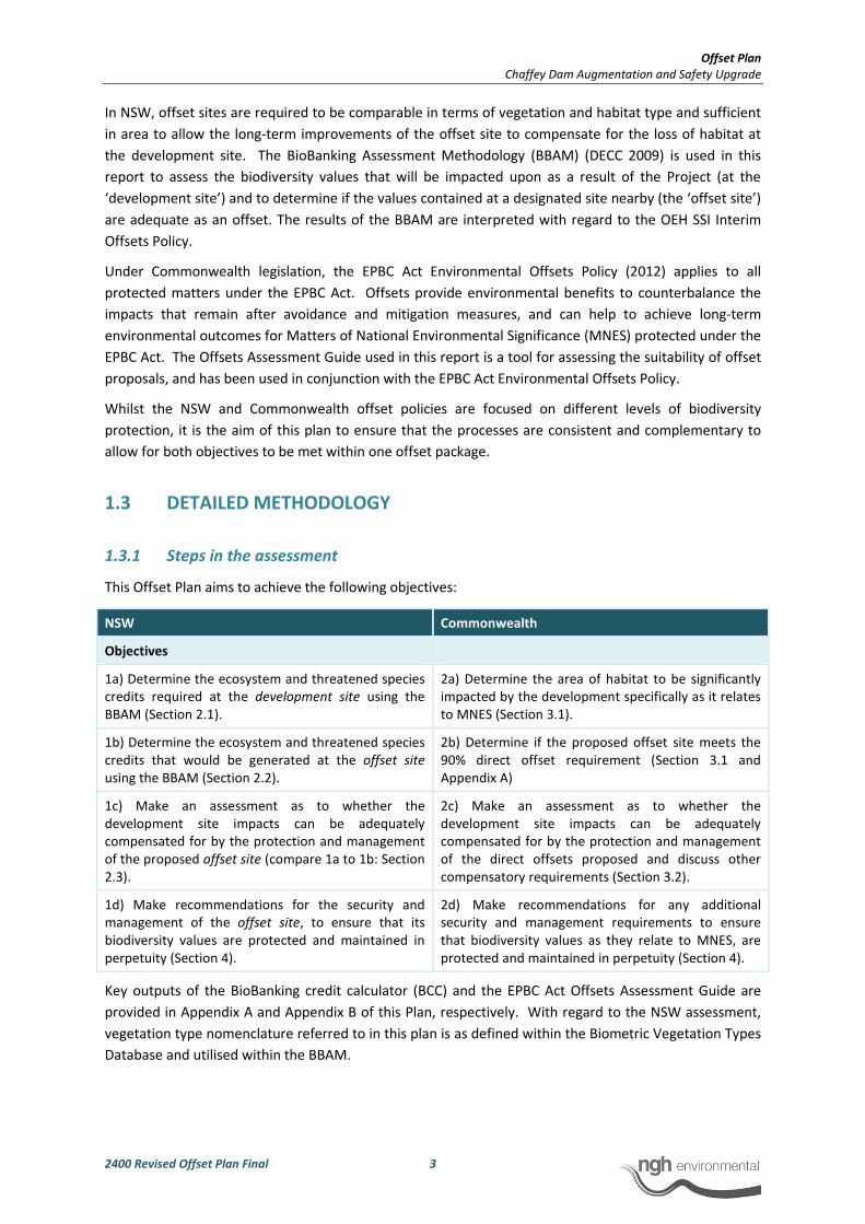
Offset Plan
Chaffey Dam Augmentation and Safety Upgrade
2400 Revised Offset Plan Final 3
In NSW, offset sites are required to be comparable in terms of vegetation and habitat type and sufficient
in area to allow the long-term improvements of the offset site to compensate for the loss of habitat at
the development site. The BioBanking Assessment Methodology (BBAM) (DECC 2009) is used in this
report to assess the biodiversity values that will be impacted upon as a result of the Project (at the
‘development site’) and to determine if the values contained at a designated site nearby (the ‘offset site’)
are adequate as an offset. The results of the BBAM are interpreted with regard to the OEH SSI Interim
Offsets Policy.
Under Commonwealth legislation, the EPBC Act Environmental Offsets Policy (2012) applies to all
protected matters under the EPBC Act. Offsets provide environmental benefits to counterbalance the
impacts that remain after avoidance and mitigation measures, and can help to achieve long-term
environmental outcomes for Matters of National Environmental Significance (MNES) protected under the
EPBC Act. The Offsets Assessment Guide used in this report is a tool for assessing the suitability of offset
proposals, and has been used in conjunction with the EPBC Act Environmental Offsets Policy.
Whilst the NSW and Commonwealth offset policies are focused on different levels of biodiversity
protection, it is the aim of this plan to ensure that the processes are consistent and complementary to
allow for both objectives to be met within one offset package.
1.3 DETAILED METHODOLOGY
1.3.1 Steps in the assessment
This Offset Plan aims to achieve the following objectives:
NSW Commonwealth
Objectives
1a) Determine the ecosystem and threatened species
credits required at the development site using the
BBAM (Section 2.1).
2a) Determine the area of habitat to be significantly
impacted by the development specifically as it relates
to MNES (Section 3.1).
1b) Determine the ecosystem and threatened species
credits that would be generated at the offset site
using the BBAM (Section 2.2).
2b) Determine if the proposed offset site meets the
90% direct offset requirement (Section 3.1 and
Appendix A)
1c) Make an assessment as to whether the
development site impacts can be adequately
compensated for by the protection and management
of the proposed offset site (compare 1a to 1b: Section
2.3).
2c) Make an assessment as to whether the
development site impacts can be adequately
compensated for by the protection and management
of the direct offsets proposed and discuss other
compensatory requirements (Section 3.2).
1d) Make recommendations for the security and
management of the offset site, to ensure that its
biodiversity values are protected and maintained in
perpetuity (Section 4).
2d) Make recommendations for any additional
security and management requirements to ensure
that biodiversity values as they relate to MNES, are
protected and maintained in perpetuity (Section 4).
Key outputs of the BioBanking credit calculator (BCC) and the EPBC Act Offsets Assessment Guide are
provided in Appendix A and Appendix B of this Plan, respectively. With regard to the NSW assessment,
vegetation type nomenclature referred to in this plan is as defined within the Biometric Vegetation Types
Database and utilised within the BBAM.
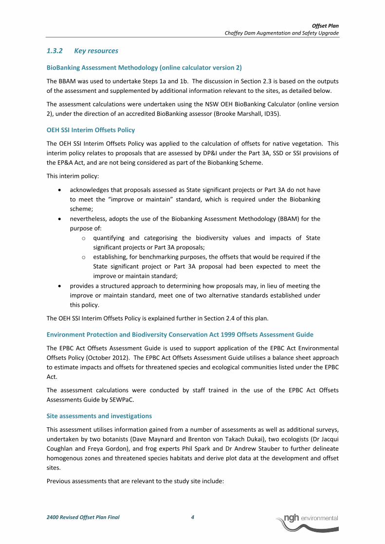
Offset Plan
Chaffey Dam Augmentation and Safety Upgrade
2400 Revised Offset Plan Final 4
1.3.2 Key resources
BioBanking Assessment Methodology (online calculator version 2)
The BBAM was used to undertake Steps 1a and 1b. The discussion in Section 2.3 is based on the outputs
of the assessment and supplemented by additional information relevant to the sites, as detailed below.
The assessment calculations were undertaken using the NSW OEH BioBanking Calculator (online version
2), under the direction of an accredited BioBanking assessor (Brooke Marshall, ID35).
OEH SSI Interim Offsets Policy
The OEH SSI Interim Offsets Policy was applied to the calculation of offsets for native vegetation. This
interim policy relates to proposals that are assessed by DP&I under the Part 3A, SSD or SSI provisions of
the EP&A Act, and are not being considered as part of the Biobanking Scheme.
This interim policy:
• acknowledges that proposals assessed as State significant projects or Part 3A do not have
to meet the “improve or maintain” standard, which is required under the Biobanking
scheme;
• nevertheless, adopts the use of the Biobanking Assessment Methodology (BBAM) for the
purpose of:
o quantifying and categorising the biodiversity values and impacts of State
significant projects or Part 3A proposals;
o establishing, for benchmarking purposes, the offsets that would be required if the
State significant project or Part 3A proposal had been expected to meet the
improve or maintain standard;
• provides a structured approach to determining how proposals may, in lieu of meeting the
improve or maintain standard, meet one of two alternative standards established under
this policy.
The OEH SSI Interim Offsets Policy is explained further in Section 2.4 of this plan.
Environment Protection and Biodiversity Conservation Act 1999 Offsets Assessment Guide
The EPBC Act Offsets Assessment Guide is used to support application of the EPBC Act Environmental
Offsets Policy (October 2012). The EPBC Act Offsets Assessment Guide utilises a balance sheet approach
to estimate impacts and offsets for threatened species and ecological communities listed under the EPBC
Act.
The assessment calculations were conducted by staff trained in the use of the EPBC Act Offsets
Assessments Guide by SEWPaC.
Site assessments and investigations
This assessment utilises information gained from a number of assessments as well as additional surveys,
undertaken by two botanists (Dave Maynard and Brenton von Takach Dukai), two ecologists (Dr Jacqui
Coughlan and Freya Gordon), and frog experts Phil Spark and Dr Andrew Stauber to further delineate
homogenous zones and threatened species habitats and derive plot data at the development and offset
sites.
Previous assessments that are relevant to the study site include:
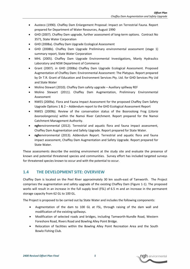
Offset Plan
Chaffey Dam Augmentation and Safety Upgrade
2400 Revised Offset Plan Final 5
• Austeco (1990). Chaffey Dam Enlargement Proposal: Impact on Terrestrial Fauna. Report
prepared for Department of Water Resources, August 1990
• GHD (2007). Chaffey Dam upgrade, further assessment of long-term options. Contract No
3571, State Water Corporation
• GHD (2008a). Chaffey Dam Upgrade Ecological Assessment
• GHD (2008b). Chaffey Dam Upgrade Preliminary environmental assessment (stage 1)
summary report, State Water Corporation
• MHL (2005). Chaffey Dam Upgrade Environmental Investigations, Manly Hydraulics
Laboratory and NSW Department of Commerce
• Grant (2007). in GHD (2008a) Chaffey Dam Upgrade Ecological Assessment. Proposed
Augmentation of Chaffey Dam: Environmental Assessment: The Platypus. Report prepared
by Dr T.R. Grant of Education and Environment Services Pty. Ltd. for GHD Services Pty Ltd
and State Water
• Molino Stewart (2010). Chaffey Dam safety upgrade – Auxiliary spillway REF
• Molino Stewart (2011). Chaffey Dam Augmentation, Preliminary Environmental
Assessment
• NWES (2009a). Flora and Fauna Impact Assessment for the proposed Chaffey Dam Safety
Upgrade Options 1 & 2 – Addendum report to the GHD Ecological Assessment Report
• NWES (2009b). Review of the conservation status of the Booroolong Frog (Litoria
booroolongensis) within the Namoi River Catchment. Report prepared for the Namoi
Catchment Management Authority.
• nghenvironmental (2012). Terrestrial and aquatic flora and fauna impact assessment,
Chaffey Dam Augmentation and Safety Upgrade. Report prepared for State Water.
• nghenvironmental (2013). Addendum Report. Terrestrial and aquatic flora and fauna
impact assessment, Chaffey Dam Augmentation and Safety Upgrade. Report prepared for
State Water.
These assessments describe the existing environment at the study site and evaluate the presence of
known and potential threatened species and communities. Survey effort has included targeted surveys
for threatened species known to occur and with the potential to occur.
1.4 THE DEVELOPMENT SITE: OVERVIEW
Chaffey Dam is located on the Peel River approximately 30 km south-east of Tamworth. The Project
comprises the augmentation and safety upgrade of the existing Chaffey Dam (Figure 1-1). The proposed
works will result in an increase in the full supply level (FSL) of 6.5 m and an increase in the permanent
storage capacity from 62 GL to 100 GL.
The Project is proposed to be carried out by State Water and includes the following components:
• Augmentation of the dam to 100 GL at FSL, through raising of the dam wall and
modification of the existing spillways.
• Modification of selected roads and bridges, including Tamworth-Nundle Road, Western
Foreshore Road, Rivers Road and Bowling Alley Point Bridge.
• Relocation of facilities within the Bowling Alley Point Recreation Area and the South
Bowlo Fishing Club.

Offset Plan
Chaffey Dam Augmentation and Safety Upgrade
2400 Revised Offset Plan Final 6
The Project will result in an increase to the FSL footprint of approximately 185 ha, in areas surrounding
the existing reservoir and an additional footprint of up to 38 ha for the realignment of existing roads and
bridges.
1.4.1 Impacts of the Project
The Project will impact on areas of habitat that comprise EEC and habitat for threatened species. Impacts
on native vegetation will predominately result from inundation with additional areas being cleared for
associated road works (refer Table 1-1).
Impacts to vegetation to be offset in accordance with OEH SSI Interim Offsets Policy (and consequently
the BBAM) are highlighted in Table 1-1.
Table 1-1 Approximate impact areas of the Project by vegetation type
Regional Vegetation Community Area to be inundated (ha) Additional Road
Area Impact (ha)
Yellow Box - Blakely's Red Gum grassy woodland of the
Nandewar Bioregion (TSC listed White Box-Yellow Box-
Blakely's Red Gum Woodland EEC)
117 33
Rough-barked Apple - Silvertop Stringybark - Red
Stringybark grassy open forest of south western New
England Tablelands
3 1
River Oak riparian woodland of the Brigalow Belt
South and Nandewar Bioregions (Benson 84) 6 0
Semi-permanent open freshwater wetlands of the
inland slopes and plains 0.24 0
Planted non-indigenous native vegetation 9 2
Exotic non-native vegetation 45 2
TOTAL 180.25 38
Impacts on threatened species and communities
The Project will result in the effective removal (through inundation or clearing) of approximately 150 ha
of Yellow Box - Blakely's Red Gum grassy woodland of the Nandewar Bioregion, which is listed as an EEC
(White Box-Yellow Box-Blakely’s Red Gum Woodland) under the NSW TSC Act.
Approximately 7 ha of this community also meet the criteria for the Commonwealth (EPBC Act) listed
White Box-Yellow Box-Blakely’s Red Gum Woodland and Derived Native Grasslands Critically Endangered
Ecological Community (CEEC). The Terrestrial and Aquatic Flora and Fauna Impact Assessment
(nghenvironmental 2012) concluded that no significant impact to this CEEC will result from the Project.
Accordingly, no offset for the Yellow Box - Blakely's Red Gum grassy woodland is required under the EPBC
Act Environmental Offsets Policy.
The Project will result in the inundation of an area supporting a population of the endangered
Booroolong Frog (Litoria booroolongensis) (TSC and EPBC Acts) along the Peel River, directly upstream of
Chaffey Dam. Approximately 1.6 km of habitat for this species would be effectively removed as a result
of the Project. This would result in a significant impact to this species.

Offset Plan
Chaffey Dam Augmentation and Safety Upgrade
2400 Revised Offset Plan Final 7
Requirement to offset
All residual impacts are required to be offset in accordance with the NSW OEH SSI Interim offsets Policy.
Where significant residual impacts to matters of national environmental significance remain (such as the
identified impacts of the Project on the Booroolong Frog), these are also required to be offset in
accordance with the EPBC Act Environmental Offsets Policy.
1.5 THE PROPOSED OFFSET SITE: OVERVIEW
State Water has nominated an area of land, approximately 980 ha in size, on the northern and western
foreshore of the dam for consideration as an offset site (the North-West Offset Site). The land identified
for the offset site is registered in the name of the Water Administration and Ministerial Corporation
(WAMC). This land is vested in State Water and available for State Water to enter into covenants or
agreements (Figure 1-1). Part of the land, comprising the area west of the Western Foreshore Road is
currently leased to local farmers for grazing on a permissive occupancy basis. They have been informed
that this lease will be terminated on 31 December 2013 and from that time onwards the land will be
available for dedication as an offset site. To the east of the Western Foreshore Road, the offset area is
not being used for any activities excluding the far eastern section where it surrounds the existing dam.
Within this area, there appears to be some grazing by cattle on the floodplain associated with the Peel
River. The Peel River is also accessed by the general public for recreational purposes.
The proposed North-West offset site contains vegetation similar to that within the development
footprint. Yellow Box – Blakely’s Red Gum grassy woodland occupies the lower slopes and Rough-barked
Apple – Silvertop Stringybark forest on the steeper upper slopes and River Oak riparian woodland along
the Peel River. However, it also includes another community, White Box grassy woodland, which occurs
as an intermediate between the Yellow Box and Silvertop Stringybark communities.
The Yellow Box – Blakely’s Red Gum grassy woodland and White Box grassy woodland (collectively “Box-
gum woodland”) are considered to comprise the TSC listed White Box-Yellow Box-Blakely's Red Gum
Woodland EEC. Components of these communities also comprise the EPBC listed White Box-Yellow Box-
Blakely's Red Gum Grassy Woodland and Derived Native Grassland Critically Endangered Ecological
Community (CEEC).
The offset site supports known habitat for threatened fauna species including the Regent Honeyeater,
Border Thick-tailed Gecko and Speckled Warbler (Atlas of NSW Wildlife accessed 24/08/2012; NWES
2009a). The offset site provides suitable habitat for a range of other threatened fauna species including
the Spotted-tailed Quoll, Little Lorikeet, and woodland birds including the Brown Treecreeper.
An additional offset site is proposed for the Booroolong Frog upstream of the impact area along the Peel
River for a length of 9 km (the Booroolong Frog Offset Site). This area is known habitat for the
Booroolong Frog (Figure 3-1).
The proposed Booroolong Frog Offset Site is currently managed by landholders under a 10 year
Management Agreement (MA) with Namoi CMA. Lands currently subject to this MA are displayed in
Appendix C. These MAs are due to expire in five years (2018). The current MAs can be terminated with
one month notice and are not attached in any way to the title of the land. The current MAs have a range
of conditions agreed to by four Funding Recipients (see Appendix C). However, the effectiveness of
actions carried out under these conditions is unclear, as no formal management plans exist and no
monitoring data is available. Despite these MAs, residual threats to the Booroolong Frog such as stock
access and weeds, are still ongoing (Phil Spark, pers. comm.) and Anna Cronin of Namoi CMA has stated
that while there has been some success the management actions need to be ongoing and controls need

Offset Plan
Chaffey Dam Augmentation and Safety Upgrade
2400 Revised Offset Plan Final 8
to be tighter. The current MAs focus on restrictions in land use, but do not include actions to actively
manage and improve habitat along the Peel River. Under the present management the future quality of
the offset site is uncertain. Furthermore, the proposed offset plan will incorporate additional
management measures to value-add to those conditions already in place. Management actions for the
offset site will greatly improve on restoration and revegetation of the riparian zone. The effectiveness of
management actions will be assessed during annual monitoring. Compliance with those management
measures will also be assessed. Management Plans will be adaptive to allow for amendments in
response to monitoring results.
The location of the ‘development site’ and proposed ‘offset sites’ are shown in Figure 1-1.
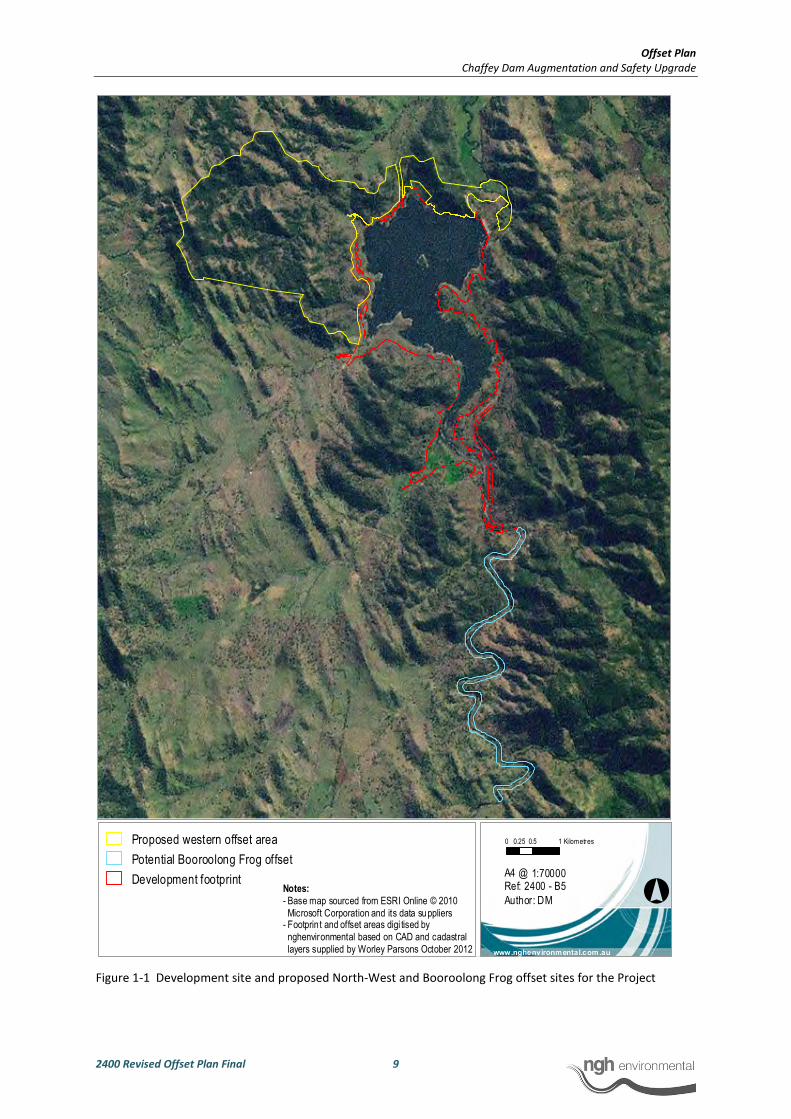
Offset Plan
Chaffey Dam Augmentation and Safety Upgrade
2400 Revised Offset Plan Final 9
Figure 1-1 Development site and proposed North-West and Booroolong Frog offset sites for the Project
°
0 0.5 10.25 Kilometres
1:70000
www.nghenvironmental.com.au
A4 @ Ref: 2400 - B5
Author: DM
Proposed western offset area
Potential Booroolong Frog offset
Development footprintNotes:
- Base map sourced from ESRI Online © 2010
Microsoft Corporation and its data suppliers- Footprint and offset areas digi tised by
nghenvironmental based on CAD and cadastral
layers supplied by Worley Parsons October 2012
Offset Plan
Chaffey Dam Augmentation and Safety Upgrade
2400 Revised Offset Plan Final 10
2 NSW OFFSET REQUIREMENTS
The OEH endorsed BBAM has been utilised to assess the suitability of the proposed offset site to
adequately offset the impacts associated with the development with regard to the requirements of the
State. The OEH SSI Interim Offsets Policy adopts the use of the BBAM for the purposes of:
• quantifying and categorising the biodiversity values and impacts of State significant
projects
• establishing, for benchmarking purposes, the offsets that would be required if the State
significant project had been expected to meet the improve or maintain standard.
The OEH SSI Interim Offsets Policy acknowledges that proposals assessed as State significant projects do
not have to meet the “improve or maintain” standard which is required under the BioBanking scheme.
The BBAM instead provides a structured approach to determining how proposals may meet one of two
alternative standards established under the policy (refer to Section 2.4).
The key steps that are involved in the methodology are outlined below along with explanations for key
decisions and any variations from the methodology. The BBAM assesses the development and proposed
offset sites individually to determine the number of credits that are required of generated respectively.
As such, each assessment is outlined individually.
2.1 DEVELOPMENT SITE CREDITS
Within the BCC, this assessment is proposal ID 0035/2013/0467D V1.
2.1.1 Delineation of the development site
For the purposes of this assessment, the development site was defined as all areas that would be
permanently impacted by the proposal. This included the entire area within the new FSL and all areas
within the proposed road works footprint.
2.1.2 Landscape assessment
The development site occurs within the Namoi Catchment Management Area, Peel subregion. The
majority of the site falls within the Tamworth - Keepit Slopes and Plains Mitchell Landscape along the
northern, western and southern foreshores of the dam. Some areas in close proximity to the dam occur
within the Peel Channels and Floodplain Mitchell Landscape while on the eastern side of the dam and
upstream areas of the development site, some areas extend into the Nundle Hills Mitchell Landscape.
For the purposes of the BioBanking Calculator, the Tamworth - Keepit Slopes and Plains Mitchell
Landscape has been used as it is the dominant landscape across the development site.
Two ‘1000 ha assessment circles’ were required to cover the development site (outer yellow lines, Figure
2-1)1. Adjacent remnant vegetation has been disturbed by clearing and agricultural practices in the past
and the properties continue to be grazed by cattle. The vegetation communities are comprised of forest,
1 A small proportion of the development site occurs outside of the assessment circles. This area is
predominantly cleared of overstorey and therefore would not influence the landscape assessment. This
approach was discussed with the OEH BioBanking team (Andrew Remnant pers. comm. 04.02.3013) and
considered appropriate.
Offset Plan
Chaffey Dam Augmentation and Safety Upgrade
2400 Revised Offset Plan Final 11
woodland and derived grasslands with a predominantly native species composition although some areas
that have been subject to pasture improvement now contain predominately exotic vegetation.
Within the northern assessment circle, the percentage overstorey cover is scored as 21-30% before and
after development within the 1000 ha circle and 31-40% prior to development and 21-30% after
development within the 100 ha circle. Within the southern assessment circle, the percentage overstorey
cover is scored as 51-60% before and after development within the 1000 ha circle and 41-50% before and
after development within the 100ha circle. The 100 ha circles has been placed to capture the greatest
impact from the development as required by the BBAM.
The ‘most limiting link’ was identified in the south-west of the development site and has a width of
approximately 160 m. The average condition of the link is moderate to good, determined on the basis of
overstorey cover and projected foliage cover (PFC) has been rated at >25% of the lower benchmark. The
groundcover in this area is predominately exotic.
The development would have a major impact on this link as it would be inundated within the new FSL.
No native or midstorey/ground cover was recorded within the after development fields.
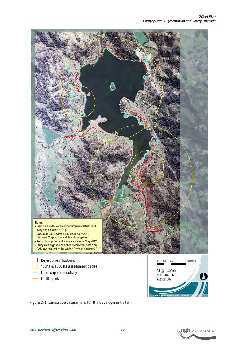
Offset Plan
Chaffey Dam Augmentation and Safety Upgrade
2400 Revised Offset Plan Final 12
Figure 2-1 Landscape assessment for the development site
°
0 0.5 10.25 Kilometres
1:40000
www.nghenvironmental.com.au
A4 @ Ref: 2400 - B1
Author: DM
Development footprint
100ha & 1000 ha assessment circles
Landscape connectivity
Limiting link
Notes:
- Field data collected by nghenvironmental field staff
(May and October 2012 )
- Base map sourced from ESRI Online © 2010 Microsoft Corporation and its data suppliers
- Aerial photo provided by Worley Parsons May 2012
- Study area digitised by nghenvironmental based on
CAD layers supplied by Worley Parsons October 2012

Offset Plan
Chaffey Dam Augmentation and Safety Upgrade
2400 Revised Offset Plan Final 13
2.1.3 Mapping zones
‘Homogenous vegetation zones’ were mapped during the Terrestrial and Aquatic Flora and Fauna Impact
Assessment (FFA) (nghenvironmental 2012) for the Project and have been refined during subsequent
surveys. It should be noted that although separate vegetation types were defined in the FFA for Box-
Gum grassy woodland and derived grassland, that within the BBAM, derived grasslands are included
within the vegetation types they are derived from. Hence, the Box-Gum grassy woodland and derived
grasslands have been mapped as a single zone.
Three homogenous zones were mapped on the basis of vegetation type and condition corresponding to
the permanent development footprint. Dominant vegetation types were determined with reference to
previous detailed assessments at the site (nghenvironmental 2012) and the OEH Biometric Vegetation
Types Database. It should be noted that there are only two Biometric condition categories for native
vegetation: ‘low’ and ‘moderate to good’. The ‘moderate to good’ category includes the relatively
degraded pasture derived from woodland communities as it is still predominately native, albeit low
diversity. Although all zones are considered moderate to good, the plot data are intended to provide the
more precise measurement of vegetation quality in the Biometric assessment.
The zones are defined in Table 2-1 and mapped on Figure 2-22. Remnant areas were assessed to be over
500 ha for all zones as all surrounding vegetation is considered to be native vegetation. Plot data was
collected based on the entire area of each homogenous zone and the number of plots conducted was
sufficient to meet the minimum requirements for these areas. However, once the site was divided into
two assessment circles, then the number of plots required becomes specific to each homogenous zone
within each circle and the number required increased. The condition of the vegetation at the site is
relatively consistent, that the BBAM is being used only to indicate the suitability of the proposed offset
and that the number of plots undertaken was sufficient to satisfy the requirements of the methodology.
It was decided in consultation with OEH (David Coote pers. comm. 06.02.13) that it was acceptable to
duplicate some of the plot data within each assessment circle to meet the required number of plots.
Plots that have been duplicated are denoted in Table 2-1 by an asterisk (*). Plots duplicated are those
that were located closest to the relevant assessment circle.
Geographic/habitat features were selected with respect to threatened species as outlined in
2 No individual map unit was less than 0.25ha. Vegetation that did not qualify as native vegetation was not
mapped. This included areas with no native overstorey, no native mid storey and where less than 50% of the
ground cover is indigenous species or greater than 90% of the ground cover was cleared.

Offset Plan
Chaffey Dam Augmentation and Safety Upgrade
2400 Revised Offset Plan Final 14
Table 2-2. Suitable habitat was identified at the development site for eight species.
‘After development’ management scores were decreased to zero, assuming that all habitat within the
development footprint would be effectively removed by the Project.

Offset Plan
Chaffey Dam Augmentation and Safety Upgrade
2400 Revised Offset Plan Final 15
Table 2-1. Development site: homogenous zones
Assessment
circle
ZONE
ID
Vegetation
type code
Vegetation name Condition Area
effectively
removed
(ha)
Plot IDs
North 1 NA237 Yellow Box - Blakely's
Red Gum grassy
woodland of the
Nandewar Bioregion
Moderate/
Good
89.58 D4, D5, D6,
D7*, D8*,
D9*
North 2 NA196 Rough-barked Apple -
Silvertop Stringybark -
Red Stringybark grassy
open forest of south
western New England
Tablelands
Moderate/
Good
3.11 D1, D2, D3*,
D16
South 4 NA237 Yellow Box - Blakely's
Red Gum grassy
woodland of the
Nandewar Bioregion
Moderate/
Good
62.77 D7*, D8*,
D9*, D14,
D15
South 5 NA196 Rough-barked Apple -
Silvertop Stringybark -
Red Stringybark grassy
open forest of south
western New England
Tablelands
Moderate/
Good
0.54 D3*
South 6 NA191 River Oak riparian
woodland of the
Brigalow Belt South and
Nandewar Bioregions
(Benson 84)
Moderate/
Good
5.71 D11, D12,
D13
* Duplicated plot data

Offset Plan
Chaffey Dam Augmentation and Safety Upgrade
2400 Revised Offset Plan Final 16
Table 2-2 Threatened species considered to occur at the development site according to relevant habitat
features
Common
name Scientific name Feature
Austral
Toadflax
Thesium australe Coastal headlands, grassland, grassy open forest or woodland on
fertile or moderately fertile soils
Grey-headed
Flying-fox
(Breeding)
Pteropus
poliocephalus
Land within 40 m of rainforest, coastal scrub, riparian or
estuarine communities
Border Thick-
tailed Gecko
Uvidicolus sphyrurus Land within 100 m of rocky areas
Narrow-leaved
Black
Peppermint
Eucalyptus nicholii Shallow or infertile soils
Black-breasted
Buzzard
Hamirostra
melanosternon
Land within 40 m of riparian woodland on inland
watercourses/waterholes containing dead or dying eucalypts
Dungowan
Starbush
Asterolasia sp.
'Dungowan Creek'
Land within Dungowan Dam area near Tamworth in Peel CMA
subregion
Pale-headed
Snake
Hoplocephalus
bitorquatus
Land within 40 m of watercourses, containing hollow-bearing
trees, loose bark and/or fallen timber
Booroolong
Frog
Litoria
booroolongensis
Land within 100 m of stream or creek banks
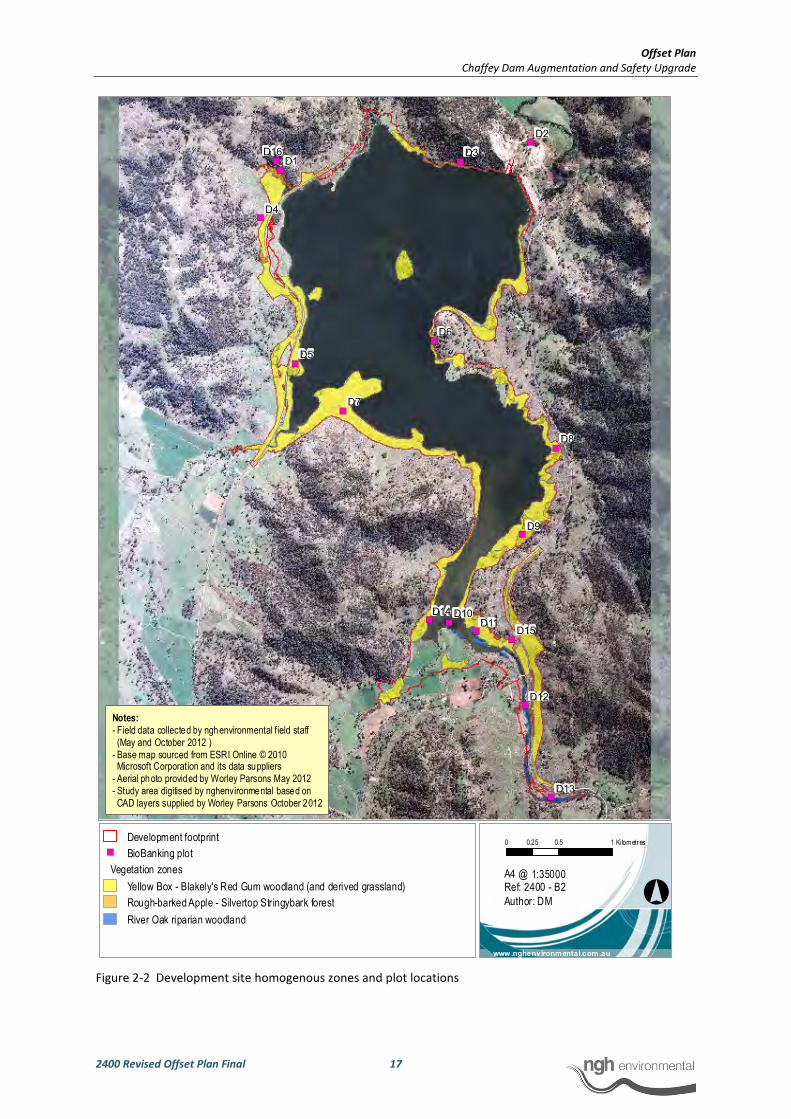
Offset Plan
Chaffey Dam Augmentation and Safety Upgrade
2400 Revised Offset Plan Final 17
Figure 2-2 Development site homogenous zones and plot locations
�)
�)
�)
�)
�)
�)
�)
�)
�)
�)
�)
�)
�) �)
�)
�)
D2
D3D1
D7
D4
D9
D8
D5
D6
D10
D16
D12
D13
D11D15
D14
°
0 0.5 10.25 Kilometres
1:35000
www.nghenvironmental.com.au
A4 @ Ref: 2400 - B2
Author: DM
Development footprint
�) BioBanking plot
Vegetation zones
Yellow Box - Blakely's Red Gum woodland (and derived grassland)
Rough-barked Apple - Silvertop Stringybark forest
River Oak riparian woodland
Notes:
- Field data collected by nghenvironmental field staff
(May and October 2012 )
- Base map sourced from ESRI Online © 2010 Microsoft Corporation and its data suppliers
- Aerial photo provided by Worley Parsons May 2012
- Study area digitised by nghenvironmental based on
CAD layers supplied by Worley Parsons October 2012

Offset Plan
Chaffey Dam Augmentation and Safety Upgrade
2400 Revised Offset Plan Final 18
2.1.4 Credit calculator results
Species predicted to occur
The species listed in Table 2-3 are predicted by the BCC to occur at the development site and contribute
to the ecosystem credits required to be offset. The Tg values are accessed by the BBAM from the
Threatened Species Profile Database (TSPD). They are a measure of the species ability to respond to
improvement in site value or habitat value at a BioBank (offset) site. They are also used in the
calculations performed for the development site to determine ecosystem credits required.
Table 2-3 Species predicted by the BCC to occur at the development site
Scientific name Common name Tg value
Climacteris picumnus victoriae Brown Treecreeper (eastern subspecies) 0.5
Dasyurus maculatus Spotted-tailed Quoll 0.35
Falsistrellus tasmaniensis Eastern False Pipistrelle 0.45
Glossopsitta pusilla Little Lorikeet 0.58
Grantiella picta Painted Honeyeater 0.75
Lathamus discolor Swift Parrot 0.75
Melithreptus gularis gularis Black-chinned Honeyeater (eastern
subspecies) 0.75
Miniopterus schreibersii oceanensis Eastern Bentwing-bat 0.75
Neophema pulchella Turquoise Parrot 0.55
Ninox connivens Barking Owl 0.33
Ninox strenua Powerful Owl 0.33
Nyctophilus timoriensis Greater Long-eared Bat (south eastern
form) 0.48
Petaurus australis Yellow-bellied Glider 0.43
Petaurus norfolcensis Squirrel Glider 0.45
Petroica boodang Scarlet Robin 0.6
Petroica phoenicea Flame Robin 0.6
Phascolarctos cinereus Koala 0.83
Pomatostomus temporalis
temporalis Grey-crowned Babbler (eastern subspecies) 0.75
Pteropus poliocephalus Grey-headed Flying-fox 0.93
Pyrrholaemus saggitatus Speckled Warbler 0.4
Saccolaimus flaviventris Yellow-bellied Sheathtail-bat 0.45
Stagonopleura guttata Diamond Firetail 0.75
Tyto novaehollandiae Masked Owl 0.33
Xanthomyza phrygia Regent Honeyeater 0.75

Offset Plan
Chaffey Dam Augmentation and Safety Upgrade
2400 Revised Offset Plan Final 19
Species requiring survey
A total of 15 species were returned by the calculator requiring survey (Table 2-4). An extensive series of
surveys were undertaken as part of the Terrestrial and Aquatic Flora and Fauna Impact Assessment
(nghenvironmental 2012) which allowed for the confident conclusion that ten of these species were
unlikely to occur at the development site and would not be impacted by the development. No impact
was assumed for an additional three species based on the lack of habitat availability within the
development site and proximity of nearest records. One species, the Border Thick-tailed Gecko, is known
to occur at the site but will not be impacted by the Project. One species requiring survey, the Booroolong
Frog, was recorded during surveys at the site and has the potential to be impacted by the development.
The impact to this species generates species credits that require offsetting.
Table 2-4 Species requiring survey at the development site and potential to be impacted
Scientific name Common name Impacted? ID method Loss Units
of loss
Tg
value
Thesium australe Austral Toadflax No Survey 0.00 indiv 0.58
Hieraaetus morphnoides Little Eagle No Survey 0.00 ha 0.74
Circus assimilis Spotted Harrier No Survey 0.00 ha 0.74
Pteropus poliocephalus Grey-headed Flying-
fox (Breeding) No Survey 0.00 ha 0.93
Dichanthium setosum Bluegrass No Survey 0.00 indiv 0.13
Digitaria porrecta Finger Panic Grass No Assumed 0.00 indiv 0.75
Phascogale tapoatafa Brush-tailed
Phascogale No Assumed 0.00 ha 0.5
Lophoictinia isura Square-tailed Kite No Survey 0.00 ha 0.74
Callocephalon
fimbriatum Gang-gang Cockatoo No Assumed 0.00 ha 0.5
Uvidicolus
(Underwoodisaurus)
sphyrurus
Border Thick-tailed
Gecko No Survey 0.00 ha 0.75
Eucalyptus nicholii Narrow-leaved Black
Peppermint No Survey 0.00 indiv 0.7
Hamirostra
melanosternon
Black-breasted
Buzzard No Survey 0.00 ha 0.74
Asterolasia sp.
'Dungowan Creek' Dungowan Starbush No Survey 0.00 indiv 0.13
Hoplocephalus
bitorquatus Pale-headed Snake No Assumed 0.00 ha 0.3
Litoria booroolongensis Booroolong Frog Yes Survey 4.77 ha 0.4
Red flags: Director-General approval required
When using the BioBanking assessment pathway, red flags generated by the assessment indicate that the
Project will not be permitted without the approval of the Director General (Department of Premier and
Cabinet).
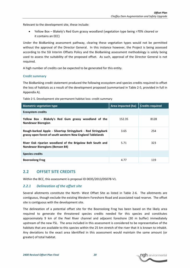
Offset Plan
Chaffey Dam Augmentation and Safety Upgrade
2400 Revised Offset Plan Final 20
Relevant to the development site, these include:
• Yellow Box – Blakely’s Red Gum grassy woodland (vegetation type being >70% cleared or
it contains an EEC)
Under the BioBanking assessment pathway, clearing these vegetation types would not be permitted
without the approval of the Director General. In this instance however, the Project is being assessed
according to the SSI Interim Offsets Policy and the BioBanking assessment methodology is solely being
used to assess the suitability of the proposed offset. As such, approval of the Director General is not
required.
A high number of credits can be expected to be generated for this entity.
Credit summary
The BioBanking credit statement produced the following ecosystem and species credits required to offset
the loss of habitats as a result of the development proposed (summarised in Table 2-5, provided in full in
Appendix A).
Table 2-5. Development site permanent habitat loss: credit summary
Biometric vegetation type Area impacted (ha) Credits required
Ecosystem credits
Yellow Box - Blakely's Red Gum grassy woodland of the
Nandewar Bioregion
152.35 8128
Rough-barked Apple - Silvertop Stringybark - Red Stringybark
grassy open forest of south western New England Tablelands
3.65 254
River Oak riparian woodland of the Brigalow Belt South and
Nandewar Bioregions (Benson 84)
5.71 323
Species credits
Booroolong Frog 4.77 119
2.2 OFFSET SITE CREDITS
Within the BCC, this assessment is proposal ID 0035/2013/0507B V1.
2.2.1 Delineation of the offset site
Several allotments constitute the North- West Offset Site as listed in Table 2-6. The allotments are
contiguous, though exclude the existing Western Foreshore Road and associated road reserve. The offset
site is contiguous with the development site.
The delineation of a potential offset site for the Booroolong Frog has been based on the likely area
required to generate the threatened species credits needed for this species and constitutes
approximately 9 km of the Peel River channel and adjacent foreshore (30 m buffer) immediately
upstream of the new FSL. The area included in this assessment is considered to be representative of the
habitats that are available to this species within the 25 km stretch of the river that it is known to inhabit.
Any deviations to the exact area identified in this assessment would maintain the same amount (or
greater) of total habitat.
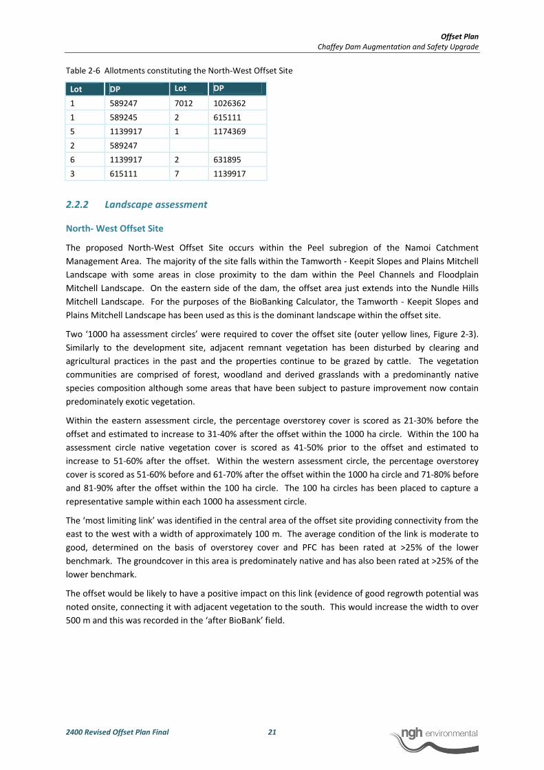
Offset Plan
Chaffey Dam Augmentation and Safety Upgrade
2400 Revised Offset Plan Final 21
Table 2-6 Allotments constituting the North-West Offset Site
Lot DP Lot DP
1 589247 7012 1026362
1 589245 2 615111
5 1139917 1 1174369
2 589247
6 1139917 2 631895
3 615111 7 1139917
2.2.2 Landscape assessment
North- West Offset Site
The proposed North-West Offset Site occurs within the Peel subregion of the Namoi Catchment
Management Area. The majority of the site falls within the Tamworth - Keepit Slopes and Plains Mitchell
Landscape with some areas in close proximity to the dam within the Peel Channels and Floodplain
Mitchell Landscape. On the eastern side of the dam, the offset area just extends into the Nundle Hills
Mitchell Landscape. For the purposes of the BioBanking Calculator, the Tamworth - Keepit Slopes and
Plains Mitchell Landscape has been used as this is the dominant landscape within the offset site.
Two ‘1000 ha assessment circles’ were required to cover the offset site (outer yellow lines, Figure 2-3).
Similarly to the development site, adjacent remnant vegetation has been disturbed by clearing and
agricultural practices in the past and the properties continue to be grazed by cattle. The vegetation
communities are comprised of forest, woodland and derived grasslands with a predominantly native
species composition although some areas that have been subject to pasture improvement now contain
predominately exotic vegetation.
Within the eastern assessment circle, the percentage overstorey cover is scored as 21-30% before the
offset and estimated to increase to 31-40% after the offset within the 1000 ha circle. Within the 100 ha
assessment circle native vegetation cover is scored as 41-50% prior to the offset and estimated to
increase to 51-60% after the offset. Within the western assessment circle, the percentage overstorey
cover is scored as 51-60% before and 61-70% after the offset within the 1000 ha circle and 71-80% before
and 81-90% after the offset within the 100 ha circle. The 100 ha circles has been placed to capture a
representative sample within each 1000 ha assessment circle.
The ‘most limiting link’ was identified in the central area of the offset site providing connectivity from the
east to the west with a width of approximately 100 m. The average condition of the link is moderate to
good, determined on the basis of overstorey cover and PFC has been rated at >25% of the lower
benchmark. The groundcover in this area is predominately native and has also been rated at >25% of the
lower benchmark.
The offset would be likely to have a positive impact on this link (evidence of good regrowth potential was
noted onsite, connecting it with adjacent vegetation to the south. This would increase the width to over
500 m and this was recorded in the ‘after BioBank’ field.
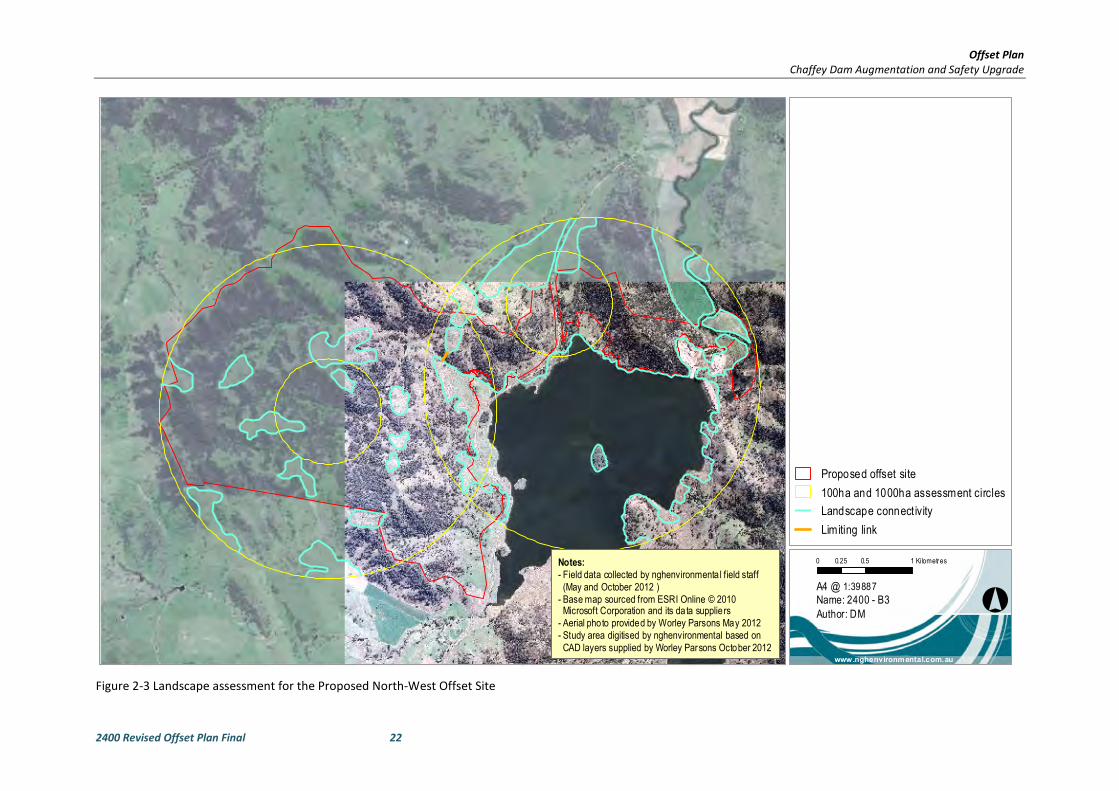
Offset Plan
Chaffey Dam Augmentation and Safety Upgrade
2400 Revised Offset Plan Final 22
Figure 2-3 Landscape assessment for the Proposed North-West Offset Site
°
0 0.5 10.25 Kilometres
1:39887
www.nghenvironmental.com.au
A4 @
Name: 2400 - B3
Author: DM
Proposed offset site
100ha and 1000ha assessment circles
Landscape connect ivity
Limiting link
Notes:
- Field data collected by nghenvironmenta l field staff
(May and October 2012 )
- Base map sourced from ESRI Online © 2010 Microsoft Corporation and its data suppliers
- Aerial photo provided by Worley Parsons May 2012
- Study area digitised by nghenvironmental based on
CAD layers supplied by Worley Parsons October 2012

Offset Plan
Chaffey Dam Augmentation and Safety Upgrade
2400 Revised Offset Plan Final 23
Booroolong Frog Offset Site
The proposed Booroolong Frog Offset Site occurs within the Peel subregion of the Namoi Catchment
Management Area. The entirety of the site falls within the Peel Channels and Floodplain Mitchell
Landscape.
Two ‘1000 ha assessment circles’ were required to cover the offset site (outer yellow lines, Figure 2-4).
Similarly to the development and western offset site, adjacent remnant vegetation has been disturbed by
clearing and agricultural practices in the past and the properties continue to be grazed by cattle.
Within the northern assessment circle, the percentage overstorey cover is scored as 51-60% before the
offset and estimated to remain the same at 51-60% after the offset within the 1000 ha circle. Within the
100 ha assessment circle native vegetation cover is scored as 51-60% prior to the offset and estimated to
remain at 51-60% after the offset. Within the southern assessment circle, the percentage overstorey cover
is scored as 21-30% before and after the offset within the 1000 ha circle and 11-20% before and after the
offset within the 100 ha circle. The 100 ha circles has been placed to capture a representative sample
within each 1000 ha assessment circle.
The ‘most limiting link’ was identified to the north-west of the offset site providing connectivity from the
east to the west with a width of greater than 500 m, however in general, most of the vegetation within the
1000 ha assessment circles is considered to be relatively well connected. The average condition of the link
is moderate to good, determined on the basis of overstorey cover and PFC has been rated at >25% of the
lower benchmark. Although not directly surveyed, the groundcover in this area is considered likely to be
predominately native (based on other vegetation surveyed with a similar landscape position and overstorey
cover) and has also been rated at >25% of the lower benchmark. The offset would have no impact on this
link.
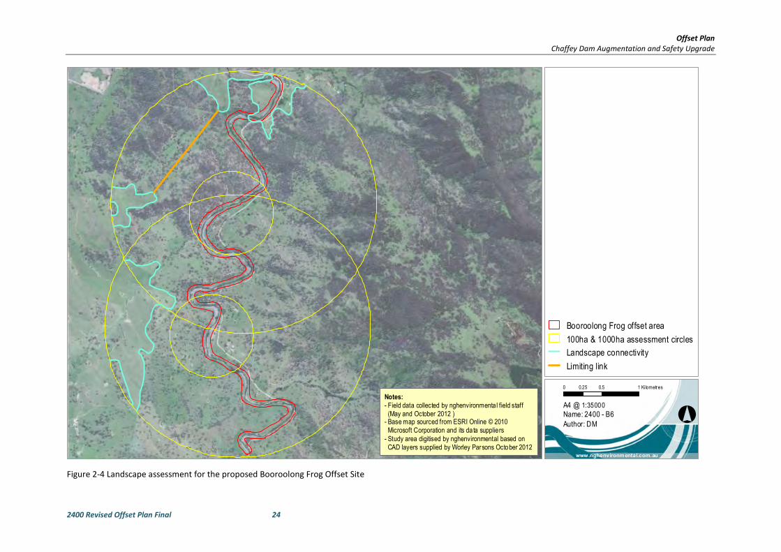
Offset Plan
Chaffey Dam Augmentation and Safety Upgrade
2400 Revised Offset Plan Final 24
Figure 2-4 Landscape assessment for the proposed Booroolong Frog Offset Site
°
0 0.5 10.25 Kilometres
1:35000
www.nghenvironmental.com.au
A4 @Name: 2400 - B6
Author: DM
Booroolong Frog offset area
100ha & 1000ha assessment circles
Landscape connectivity
Limiting link
Notes:
- Field data collected by nghenvironmenta l field staff
(May and October 2012 )- Base map sourced from ESRI Online © 2010
Microsoft Corporation and its data suppliers
- Study area digitised by nghenvironmental based on
CAD layers supplied by Worley Parsons October 2012
Offset Plan
Chaffey Dam Augmentation and Safety Upgrade
2400 Revised Offset Plan Final 25
2.2.3 Mapping zones
North-West Offset Site
Homogenous vegetation zones were broadly mapped for the majority of the North-West Offset Site
during the original Terrestrial and Aquatic Flora and Fauna Assessment (nghenvironmental 2012), which
included broad scale mapping to encompass a one kilometre radius of the development site, of which the
offset site is continuous. During surveys conducted during February 2013 to collect plot data at the
North-West Offset Site, the homogenous zones were more accurately refined. As discussed for the
development site, derived grasslands are included within the vegetation types they are derived from.
Four homogenous zones were mapped on the basis of vegetation type and condition corresponding to
the defined offset site. Dominant vegetation types were determined with reference to the previous
detailed assessments at the site (nghenvironmental 2012) and the OEH Biometric Vegetation Types
Database. All vegetation within the offset site was considered to be in moderate to good condition.
The zones are defined in Table 2-7 and mapped on Figure 2-53. Remnant areas were assessed to be over
500 ha for all zones as all surrounding vegetation is considered to be native vegetation.
Plot data was collected based on the entire area of each homogenous zone and the number of plots
conducted was sufficient to meet the minimum requirements for these areas. An exception was the
number of plots required for the Rough-barked Apple – Silvertop Stringybark forest. During the
refinement of the area of impact for the Project, following the development site surveys, two plots (D1
and D16) were located within the proposed offset. In addition Plot D3 was located slightly upslope of the
development site (but still representative of the vegetation within the development site) and also located
within the proposed offset. The plot data from these plots has been used within the offset site
calculations. Given the consistency of the vegetation within this homogenous zone and the close
proximity of the offset site to the development site, plot D2 has also been included as it was also
considered to be highly representative of vegetation and habitat features within the proposed offset site.
The use of the development site plot data for this homogenous zone was discussed with OEH (David
Coote pers. comm. 06.02.13) and considered to be acceptable given the objectives of the assessment,
that it was representative of the offset site and that the particular vegetation type is common and not of
conservation significance.
Two plots were conducted within the River Oak riparian woodland within the offset site and two were
conducted within this community upstream of the new FSL on the Peel River (plots O17 and O18, Figure
2-6) within the area proposed as an offset for the Booroolong Frog. These plots were included within the
assessment to make up the minimum plot requirement and also because they were considered to be
representative of the vegetation within the offset site.
Plot O19 was not included within the assessment as it was within an area not being considered as an
offset and not representative.
Similarly to the development site, offset site plot data was duplicated only when required to satisfy the
minimum plot requirements for each assessment circle. Plots that have been duplicated are denoted in
Table 2-7 by an (*). Plots duplicated are those that were located closest to the relevant assessment
circle.
3 No individual map unit was less than 0.25 ha. Vegetation that did not qualify as native vegetation was not mapped. This
included areas with no native overstorey, no native mid storey and where less than 50% of the ground cover is indigenous
species or greater than 90% of the ground cover was cleared.

Offset Plan
Chaffey Dam Augmentation and Safety Upgrade
2400 Revised Offset Plan Final 26
Geographic/habitat features were selected with respect to threatened species as outlined in Table 2-8.
‘After BioBank’ management scores were as determined by the BCC and not modified.
Table 2-7 North-West Offset Site: homogenous zones
Assessment
circle
ZONE
ID
Vegetation
type code
Vegetation name Condition Area within
offset (ha)
Plot IDs
East 1 NA237 Yellow Box - Blakely's
Red Gum grassy
woodland of the
Nandewar Bioregion
Moderate/
Good
76.6 O6*, O7*,
O14, O16,
O20
West 5 NA237 Yellow Box - Blakely's
Red Gum grassy
woodland of the
Nandewar Bioregion
Moderate/
Good
48.98 O3, O4, O6*,
O7*
East 2 NA196 Rough-barked Apple -
Silvertop Stringybark -
Red Stringybark grassy
open forest of south
western New England
Tablelands
Moderate/
Good
91.29 D1*, D2,
D3*, D16*,
O9*
East 3 NA191 River Oak riparian
woodland of the
Brigalow Belt South and
Nandewar Bioregions
(Benson 84)
Moderate/
Good
6.98 O17, O18,
O21, O22
East 4 NA226 White Box grassy
woodland of the
Nandewar and Brigalow
Belt South Bioregions
Moderate/
Good
53.3 O10*, O11*,
O12*, O13*,
O15*
West 6 NA196 Rough-barked Apple -
Silvertop Stringybark -
Red Stringybark grassy
open forest of south
western New England
Tablelands
Moderate/
Good
557.31 O1, O2, O5,
O9*, D1*,
D3*, D16*
West 7 NA226 White Box grassy
woodland of the
Nandewar and Brigalow
Belt South Bioregions
Moderate/
Good
142.75 O8, O10*,
O11*, O12*,
O13*, O15*
* Duplicated plot data
Offset Plan
Chaffey Dam Augmentation and Safety Upgrade
2400 Revised Offset Plan Final 27
Table 2-8 Threatened species and relevant habitat features considered to potentially occur at the North-West
offset site
Scientific name Common
name Feature
Thesium
australe
Austral
Toadflax
Coastal headlands, grassland, grassy open forest or woodland
on fertile or moderately fertile soils
Pteropus
poliocephalus
Grey-headed
Flying-fox
(Breeding)
Land within 40 m of rainforest, coastal scrub, riparian or
estuarine communities
Uvidicolus
sphyrurus
Border Thick-
tailed Gecko Land within 100 m of rocky areas
Eucalyptus
nicholii
Narrow-leaved
Black
Peppermint
Shallow or infertile soils
Asterolasia sp.
'Dungowan
Creek'
Dungowan
Starbush
Land within Dungowan Dam area near Tamworth in Peel CMA
subregion
Hoplocephalus
bitorquatus
Pale-headed
Snake
Land within 40 m of watercourses, containing hollow-bearing
trees, loose bark and/or fallen timber
Litoria
booroolongensis
Booroolong
Frog Land within 100 m of stream or creek banks
Booroolong Frog Offset Site
Vegetation within the proposed Booroolong Frog Offset Site was not surveyed beyond the locations of
the two BioBanking plots (O17 and O18) conducted in the north of the site as the boundaries of the site
had not been determined at the time of the survey. As such, detailed vegetation zone mapping has not
been undertaken. It was however, possible to map with a degree of certainty the extent of River Oak
riparian woodland based on desktop interpretation of digital aerial imagery (Figure 2-6). The areas
mapped within each assessment circle are detailed in Table 2-9.
The two plots conducted (O17 and O18) were adequate to meet the minimum number required for each
zone however, plot O17 was duplicated for each assessment circle. As discussed for the North-West
Offset Site above, this is considered acceptable given the objectives of the assessment, that it is likely to
be representative of the offset site and that the particular vegetation type is common and not of
conservation significance.
Geographic/habitat features were selected with respect to threatened species as outlined for the
western offset area in Table 2-8.

Offset Plan
Chaffey Dam Augmentation and Safety Upgrade
2400 Revised Offset Plan Final 28
Table 2-9 Homogenous zones within the Booroolong Frog Offset Site
Assessment
circle
ZONE
ID
Vegetation
type code
Vegetation name Condition Area within
offset (ha)
Plot IDs
North 8 NA191 River Oak riparian
woodland of the
Brigalow Belt South and
Nandewar Bioregions
(Benson 84)
Moderate/
Good
3.5 O17*, O18
South 9 NA191 River Oak riparian
woodland of the
Brigalow Belt South and
Nandewar Bioregions
(Benson 84)
Moderate/
Good
1.6 O17*
* Duplicated plot data

Offset Plan
Chaffey Dam Augmentation and Safety Upgrade
2400 Revised Offset Plan Final 29
Figure 2-5 North-West Offset Site homogenous zones and plot locations
�)
�)
�)
�)
�)
�)
�)
�)
�)
�)
�)�)
�)
�)
�)
�)
�)
�)
�)
�)
O9
O5
O2
O1
O8 O7
O6
O4
O3
O22
O21
O15
O13
O12O11
O10
O20
O19
O16
O14
°
0 0.5 10.25 Kilometres
1:40000
www.nghenvironmental.com.au
A4 @Name: 2400 - B4
Author: DM
Proposed offset site
�) BioBanking plot
Vegetation zones
Yellow Box - Blakely's Red Gum woodland
White Box woodland
Rough-barked Apple - Silvertop Stringybark forest
River Oak riparian woodland
Notes:
- Field data collected by nghenvironmenta l field staff
(May and October 2012 )
- Base map sourced from ESRI Online © 2010 Microsoft Corporation and its data suppliers
- Aerial photo provided by Worley Parsons May 2012
- Study area digitised by nghenvironmental based on
CAD layers supplied by Worley Parsons October 2012

Offset Plan
Chaffey Dam Augmentation and Safety Upgrade
2400 Revised Offset Plan Final 30
Figure 2-6 Booroolong Frog offset site, River Oak Riparian Woodland and plot locations.
�)
�)
O18
O17
°
0 0.5 10.25 Kilometres
1:30000
www.nghenvironmental.com.au
A4 @ Ref: 2400 - B7
Author: DM
Booroolong Frog offset area
�) BioBanking plot
River Oak riparian woodland
Notes:
- Field data collected by nghenvironmental field staff
(May and October 2012 )
- Base map sourced from ESRI Online © 2010 Microsoft Corporation and its data suppliers
- Study area digitised by nghenvironmental based on
CAD layers supplied by Worley Parsons October 2012
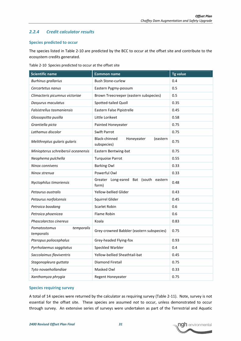
Offset Plan
Chaffey Dam Augmentation and Safety Upgrade
2400 Revised Offset Plan Final 31
2.2.4 Credit calculator results
Species predicted to occur
The species listed in Table 2-10 are predicted by the BCC to occur at the offset site and contribute to the
ecosystem credits generated.
Table 2-10 Species predicted to occur at the offset site
Scientific name Common name Tg value
Burhinus grallarius Bush Stone-curlew 0.4
Cercartetus nanus Eastern Pygmy-possum 0.5
Climacteris picumnus victoriae Brown Treecreeper (eastern subspecies) 0.5
Dasyurus maculatus Spotted-tailed Quoll 0.35
Falsistrellus tasmaniensis Eastern False Pipistrelle 0.45
Glossopsitta pusilla Little Lorikeet 0.58
Grantiella picta Painted Honeyeater 0.75
Lathamus discolor Swift Parrot 0.75
Melithreptus gularis gularis Black-chinned Honeyeater (eastern
subspecies) 0.75
Miniopterus schreibersii oceanensis Eastern Bentwing-bat 0.75
Neophema pulchella Turquoise Parrot 0.55
Ninox connivens Barking Owl 0.33
Ninox strenua Powerful Owl 0.33
Nyctophilus timoriensis Greater Long-eared Bat (south eastern
form) 0.48
Petaurus australis Yellow-bellied Glider 0.43
Petaurus norfolcensis Squirrel Glider 0.45
Petroica boodang Scarlet Robin 0.6
Petroica phoenicea Flame Robin 0.6
Phascolarctos cinereus Koala 0.83
Pomatostomus temporalis
temporalis Grey-crowned Babbler (eastern subspecies) 0.75
Pteropus poliocephalus Grey-headed Flying-fox 0.93
Pyrrholaemus saggitatus Speckled Warbler 0.4
Saccolaimus flaviventris Yellow-bellied Sheathtail-bat 0.45
Stagonopleura guttata Diamond Firetail 0.75
Tyto novaehollandiae Masked Owl 0.33
Xanthomyza phrygia Regent Honeyeater 0.75
Species requiring survey
A total of 14 species were returned by the calculator as requiring survey (Table 2-11). Note, survey is not
essential for the offset site. These species are assumed not to occur, unless demonstrated to occur
through survey. An extensive series of surveys were undertaken as part of the Terrestrial and Aquatic
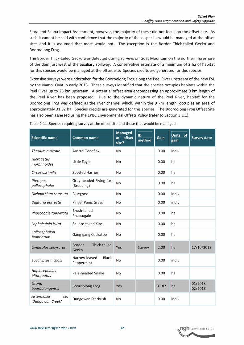
Offset Plan
Chaffey Dam Augmentation and Safety Upgrade
2400 Revised Offset Plan Final 32
Flora and Fauna Impact Assessment, however, the majority of these did not focus on the offset site. As
such it cannot be said with confidence that the majority of these species would be managed at the offset
sites and it is assumed that most would not. The exception is the Border Thick-tailed Gecko and
Booroolong Frog.
The Border Thick-tailed Gecko was detected during surveys on Goat Mountain on the northern foreshore
of the dam just west of the auxiliary spillway. A conservative estimate of a minimum of 2 ha of habitat
for this species would be managed at the offset site. Species credits are generated for this species.
Extensive surveys were undertaken for the Booroolong Frog along the Peel River upstream of the new FSL
by the Namoi CMA in early 2013. These surveys identified that the species occupies habitats within the
Peel River up to 25 km upstream. A potential offset area encompassing an approximate 9 km length of
the Peel River has been proposed. Due to the dynamic nature of the Peel River, habitat for the
Booroolong Frog was defined as the river channel which, within the 9 km length, occupies an area of
approximately 31.82 ha. Species credits are generated for this species. The Booroolong Frog Offset Site
has also been assessed using the EPBC Environmental Offsets Policy (refer to Section 3.1.1).
Table 2-11 Species requiring survey at the offset site and those that would be managed
Scientific name Common name
Managed
at offset
site?
ID
method Gain
Units of
gain Survey date
Thesium australe Austral Toadflax No 0.00 indiv
Hieraaetus
morphnoides Little Eagle No 0.00 ha
Circus assimilis Spotted Harrier No 0.00 ha
Pteropus
poliocephalus
Grey-headed Flying-fox
(Breeding) No 0.00 ha
Dichanthium setosum Bluegrass No 0.00 indiv
Digitaria porrecta Finger Panic Grass No 0.00 indiv
Phascogale tapoatafa Brush-tailed
Phascogale No 0.00 ha
Lophoictinia isura Square-tailed Kite No 0.00 ha
Callocephalon
fimbriatum Gang-gang Cockatoo No 0.00 ha
Uvidicolus sphyrurus Border Thick-tailed
Gecko Yes Survey 2.00 ha 17/10/2012
Eucalyptus nicholii Narrow-leaved Black
Peppermint No 0.00 indiv
Hoplocephalus
bitorquatus Pale-headed Snake No 0.00 ha
Litoria
booroolongensis Booroolong Frog Yes 31.82 ha
01/2013-
02/2013
Asterolasia sp.
'Dungowan Creek' Dungowan Starbush No 0.00 indiv

Offset Plan
Chaffey Dam Augmentation and Safety Upgrade
2400 Revised Offset Plan Final 33
Credit summary
The BioBanking credit statement produced the following ecosystem and species credits that are
generated at the proposed offset site (summarised in Table 2-12, provided in full in Appendix A).
Table 2-12. Offset sites: credit summary
Biometric vegetation type Area offset (ha) Credits generated
Ecosystem credits
Yellow Box - Blakely's Red Gum grassy woodland of the
Nandewar Bioregion
125.76 1500
White Box grassy woodland of the Nandewar and Brigalow Belt
South Bioregions 196.05 2019
Rough-barked Apple - Silvertop Stringybark - Red Stringybark
grassy open forest of south western New England Tablelands
649.88 7310
River Oak riparian woodland of the Brigalow Belt South and
Nandewar Bioregions (Benson 84)
12.08 231
Species credits
Border Thick-tailed Gecko 2.00 12
Booroolong Frog 31.82 112
2.3 CREDIT COMPARISON: DISCUSSION
2.3.1 North-west offset site
The summary in Table 2-13 compares the ecosystem credits generated at the North-West offset site with
those required for the development site.
Table 2-13 Credit comparison summary
Biometric vegetation type Permanent
habitat loss
(ha)
Area
within
offset
(ha)
Development
credits
required
Offset
credits
generated
Credit
difference
Yellow Box - Blakely's Red Gum
grassy woodland of the Nandewar
Bioregion
152.35 125.76 8128 1500 -6628
Rough-barked Apple - Silvertop
Stringybark - Red Stringybark grassy
open forest of south western New
England Tablelands
3.65 649.88 254 7310 7056
River Oak riparian woodland of the
Brigalow Belt South and Nandewar
Bioregions (Benson 84)
5.71 12.08 323 231 -92
White Box grassy woodland of the 0 196.05 0 2019 +2019

Offset Plan
Chaffey Dam Augmentation and Safety Upgrade
2400 Revised Offset Plan Final 34
Biometric vegetation type Permanent
habitat loss
(ha)
Area
within
offset
(ha)
Development
credits
required
Offset
credits
generated
Credit
difference
Nandewar and Brigalow Belt South
Bioregions
Total 161.71 983.77 8705 11060 +2355
Overall, the proposed offset provides a 6:1 offset to development area ratio with an ecosystem credit
surplus of 2355 credits. The proposed offset provides like for like with regards to the vegetation types it
contains however, it does not meet the credit requirements on this basis. The largest deficiency is that of
the Yellow Box – Blakely’s Red Gum grassy woodland (comprising Box-Gum grassy Woodland EEC) with a
credit shortfall of 6628 credits. This is considered to be somewhat compensated for by the White Box
grassy woodland contained at the offset site (also comprising the Box-Gum grassy woodland EEC) which
is identified in the BCC credit report (Appendix A) as a suitable offset option for this vegetation type.
Considering that both these communities are afforded the same level of statutory protection and provide
similar threatened species habitats, this is considered to be appropriate and is supported in principle by
OEH (David Coote pers. comm. 22.02.13). In combining these two vegetation types, a 2.1:1 offset to
development area ratio is achieved with a 4609 credit deficit. This is discussed further below with regard
to the SSI Interim offsets policy.
The results of the BBAM also show a shortfall in the amount of River Oak riparian woodland contained
within the offset site. The current proposed offset offers a 2.1:1 offset to development area ratio with a
92 credit deficit. This is also discussed further below with regard to the SSI Interim Offsets Policy.
The proposed North-West Offset Site may be somewhat deficient according to the outputs of the BBAM
methodology with respect to the Yellow Box – Blakely’s Red Gum grassy woodland however, a number of
other factors should be considered in assessing its suitability. The vast majority of the community that is
to be impacted comprises derived grassland that has been degraded by grazing and recreational
pressures. The proposed offset also contains degraded areas however, there are extensive areas were
the overstorey is regenerating and with proper management would respond well resulting in a net
improvement to the biodiversity values at the site within a relatively short time frame.
In addition, the North-West Offset Site provides an important corridor for connectivity between areas of
native vegetation east and west of the reservoir. The reservoir in its present state forms a large barrier in
a landscape that has also been extensively cleared for agriculture. The offset would improve the function
of this corridor and secure it in perpetuity.
The offset is also located within the catchment for Chaffey Dam and would contribute to the preservation
and improvement of catchment values associated with the water supply.
Although the Rough-barked Apple – Silvertop Stringybark forest community that comprises the majority
of the offset site is considered to be a common vegetation type, it also provides high quality habitat for a
range of threatened species such as the Masked Owl, which contributed the largest number of ecosystem
credits for this vegetation type in the development site assessment. The large area to be included in the
offset (approximately 650 ha) provides habitat suitable for species with large home ranges and it also
provides a buffer for the Yellow Box and White Box grassy woodland communities. This vegetation type
also supports habitat for the threatened Border Thick-tailed Gecko which is known to occur within the
offset site and generated a surplus of 12 species credits in the assessment.
Offset Plan
Chaffey Dam Augmentation and Safety Upgrade
2400 Revised Offset Plan Final 35
2.3.2 Booroolong Frog Offset Site
The proposed Booroolong Frog Offset Site generates 112 species credits of the 119 required, leaving a
credit deficit of 7 (6% of the requirement). These results indicate that the proposed offset almost
entirely meets the requirements of the BBAM without imposing any variations (such as those allowed by
the OEH SSI Interim Offsets Policy).
It should be noted that a riparian buffer either side of the Booroolong Frog Offset Site will be managed as
part of the Offset Site Management Plan. This is additional to the area calculated for the Booroolong
Frog Offset Site (stream channel). The restoration of the riparian zone is regarded as a high priority for
the recovery of the Booroolong Frog, and the additional approximate 50 ha that will be protected and
restored is deemed to provide a further positive outcome. Further, the Booroolong Frog offset site has
been assessed as adequate according to the EPBC Environmental Offsets Policy and this is further
discussed in Section 3.1.
2.4 ASSESSMENT OF NORTH-WEST OFFSET SITE AGAINST THE OEH SSI
INTERIM OFFSETS POLICY
The OEH SSI Interim Offsets Policy relates to proposals that are assessed by DP&I under the SSD, SSI or
former Part 3A provisions of the EP&A Act, and are not being considered as part of the BioBanking
Scheme.
This interim policy:
• Acknowledges that proposals assessed as State significant projects or Part 3A do not have
to meet the “improve or maintain” standard, which is required under the BioBanking
scheme (this would be a Tier 1 standard);
• Nevertheless, adopts the use of the BioBanking Assessment Methodology (BBAM) for the
purpose of:
o quantifying and categorising the biodiversity values and impacts of State
significant projects or Part 3A proposals;
o establishing, for benchmarking purposes, the offsets that would be required if the
State significant project or Part 3A proposal had been expected to meet the
improve or maintain standard;
o provides a structured approach to determining how proposals may, in lieu of
meeting the improve or maintain standard, meet one of two alternative standards
established under this policy referred to as Tier 2 ‘no net loss’ and Tier 3
‘mitigated net loss’.
The BBAM has been used in determining the suitability of the proposed offset. The credit comparison in
Section 2.3 demonstrates that the current proposed offset site is a Tier 3 ‘mitigated net loss’ standard.
In considering whether a mitigated net loss standard is appropriate consideration should be given to:
• Whether the credits required by the calculator are available on the market
• Whether alternative offset sites (other than credits) are available on the market
• The overall cost of the offsets and whether these costs are reasonable given the
circumstances
Consideration of the above points is discussed below:
Offset Plan
Chaffey Dam Augmentation and Safety Upgrade
2400 Revised Offset Plan Final 36
• The BioBanking Public Register was searched on the 26 February 2013 and no credits for
the Yellow Box – Blakely’s Red Gum community were found to be available on the market.
• Alternative areas of Crown land have been identified around the dam that would be
suitable as offset areas however, these areas are not in State Water ownership, are not
immediately available and may require prolonged negotiations with the land owners
which could be both time consuming and costly resulting in delays and potentially
preventing the project from proceeding.
Therefore a Tier 3 ‘mitigated net loss’ standard is considered appropriate.
To achieve a ‘mitigated net loss’ outcome, it is possible to apply specific variation criteria according to the
OEH SSI Interim Offsets Policy to the point that:
• Suitable offset sites can be found within a reasonable4 timeframe
• The costs of offsetting is brought within a reasonable4 range
• An offset to clearing ratio of at least 2:1 vegetated to cleared hectares is achieved
The variation criteria that may be applied to achieve a ‘mitigated net loss’ standard are outlined in Table
2-14 along with comments on how each of these apply to the current proposal.
Table 2-14 Variation criteria for a Tier 3 ‘mitigated net loss’ standard
Variation criteria When is this option appropriate? How this applies to this proposal
Convert ecosystem credits for one
vegetation type to any vegetation
type within the same vegetation
formation in the same IBRA
bioregion
When no matching ecosystem
credits are available
Insufficient credits are available at
the offset site for Yellow Box –
Blakely’s Red Gum grassy
woodland. White Box grassy
woodland credits have been used
to satisfy the minimum 2:1
vegetated to cleared hectares
requirement for the Box-Gum
grassy woodland TEC.
Both the Yellow Box –Blakely’s Red
Gum grassy woodland and Rough-
barked Apple - Silvertop
Stringybark - Red Stringybark
grassy open forest are of the
‘grassy woodland’ formation. This
criteria would also allow for the
transfer of the credits between
these communities, which would
then satisfy the credit
requirements of the BBAM.
Convert one type of species credit
to another type of species credit
with the same or more
endangered conservation status
When species credit is not
available and the matching species
credit is considered a greater
conservation priority.
Not applicable to this proposal.
4 As stated in the OEH SSI Interim Offsets Policy, “What is reasonable is contingent upon a range of factors and
needs to be considered on a case by case basis”.

Offset Plan
Chaffey Dam Augmentation and Safety Upgrade
2400 Revised Offset Plan Final 37
Variation criteria When is this option appropriate? How this applies to this proposal
Remove/reduce the need for
offsetting
Where clearing is minimal (less 4
ha) and where the vegetation is
not a highly cleared vegetation
type or a Commonwealth or State
listed TEC.
Not applicable to this proposal as a
TEC is being impacted.
Convert ecosystem credits
required to hectares and, if
necessary, convert hectare figure
to an estimate of land value
Where suitable offset sites are
known to exist but:
• there is insufficient time to
secure the offset sites at the
time the decision is made; or
• the proposal is to use the
services of a third party
provider such as the Nature
Conservation Trust to secure
offset sites and an estimate of
cost is required.
Not applicable to this proposal.
Waive the requirement for
species credits
NB: This criteria should not be
used for EPBC Act listed species
where the proposal is a controlled
action
Where no matching credits are
available and all ecosystem credits
have been obtained in accordance
with this policy
Not applicable to this proposal.
Species credits apply to an EPBC
listed species, the Booroolong
Frog. An offset site has been
proposed for this species using the
BBAM and the EPBC
Environmental Offsets Policy
(EOP).
Convert ecosystem credits to a
regional conservation priority as
identified in a regional
conservation plan or similar
When no matching credits are
available and variation 1 is not
feasible
Variation 1 employed for
vegetation.
The land identified for the North-west offset site is registered in the name of the Water Administration
and Ministerial Corporation (WAMC). This land is vested in State Water and available for State Water and
is available immediately. The time required to negotiate the acquisition of additional lands in multiple
ownerships, could be lengthy and has the potential to hold up the Project. The Project commits to
securing and managing lands totalling almost 1000 ha for offsets. Managing an area of this size for
conservation for the life of the dam entails a large financial commitment from State Water Corporation.
Application of the BBAM shows that an overall ratio of 6:1 vegetated to cleared hectares is achievable
including a like for like ratio of 2.1:1 for the Box-Gum grassy woodland TEC and River Oak riparian
woodland. This meets the minimum 2:1 vegetated to cleared hectares requirement. In addition,
employing variation criteria 1 allows credits to be transferred from the Rough-barked Apple - Silvertop
Stringybark - Red Stringybark grassy open forest to the Yellow Box - Blakely's Red Gum grassy woodland
community which would actually enable the credit requirements to be satisfied. The credit requirements
for the Rough-barked Apple - Silvertop Stringybark - Red Stringybark grassy open forest are easily met by
the remaining credits generated for this community.
The Project has been assessed according to the BBAM and meets the requirements for a mitigated net
loss outcome according to the OEH SSI Interim Offsets Policy. As such the proposed north-west offset is
considered to be adequate under this policy.

Offset Plan
Chaffey Dam Augmentation and Safety Upgrade
2400 Revised Offset Plan Final 38
2.5 PRINCIPLES FOR THE USE OF BIODIVERSITY OFFSETS IN NSW5 –
CHECKLIST
The following principles, developed by OEH, provide a useful framework for developing offset proposals.
They have been considered in developing this Offset Plan, as detailed below.
Impacts must be avoided first by using prevention and mitigation measures.
Offsets are then used to address remaining impacts. This may include modifying the proposal to avoid an
area of biodiversity value or putting in place measures to prevent offsite impacts.
The proposal has avoided and mitigated to the extent that the proposed new FSL is the minimum
required to meet the long term objectives of the Project. The road works footprint has been minimised
to avoid impacts to some areas of EEC. Mitigation measures have been applied and are outlined in the
Flora and Fauna Addendum Report. Residual impacts are being offset only, primarily resulting from
inundation by the raised water level of the dam.
All regulatory requirements must be met.
Offsets cannot be used to satisfy approvals or assessments under other legislation, e.g. assessment
requirements for Aboriginal heritage sites, pollution or other environmental impacts (unless specifically
provided for by legislation or additional approvals).
The Offset Plan will be required as part of the NSW consent conditions and Commonwealth Controlled
Action conditions. The proposed offsets will not be used to satisfy approvals or assessments under other
legislation.
Offsets must never reward ongoing poor performance.
Offset schemes should not encourage landholders to deliberately degrade or mismanage offset areas in
order to increase the value from the offset.
This is addressed in two ways:
a) The offset site will be set up in perpetuity – this removes the incentive to degrade the offset site
to facilitate development at a later date
b) The management measures will have clear targets and be set out to push most management to
the beginning of the agreement, where successful accomplishment of targets would be rewarded
by less intensive management in ongoing years. This suits measures such as weed control which
are more easily achieved with intensive efforts than small ongoing efforts.
Offsets will complement other government programs.
A range of tools is required to achieve the NSW Government’s conservation objectives, including the
establishment and management of new national parks, nature reserves, state conservation areas and
regional parks and incentives for private landholders.
A Conservation Agreement (CA) is the preferred option for security of the North-West Offset Site. A
Conservation Agreement is a legally binding covenant between the landholder and the Minister
established under s69A-KA of the NPW Act. It provides in-perpetuity protection for the conservation
values on the land and associated water. The agreement is registered on the title of the land, ensuring
that, if the land is sold, the agreement and management requirements remain in place for successive
5 Accessed 28 February 2013 from http://www.environment.nsw.gov.au/biocertification/offsets.htm

Offset Plan
Chaffey Dam Augmentation and Safety Upgrade
2400 Revised Offset Plan Final 39
owners. Private conservation lands complement public reserves and contribute to the protected area
system in NSW. Funding will be provided directly to the Booroolong Frog Recovery Program providing
security of funding to the Booroolong Frog Offset Site. This has the express purpose of enabling
continuation and enhancement of management activities to improve habitat for the species on the Peel
River.
Offsets must be underpinned by sound ecological principles
They must:
• include the consideration of structure, function and compositional elements of biodiversity,
including threatened species
• enhance biodiversity at a range of scales
• consider the conservation status of ecological communities
• ensure the long-term viability and functionality of biodiversity.
Biodiversity management actions, such as enhancement of existing habitat and securing and managing
land of conservation value for biodiversity, can be suitable offsets. Reconstruction of ecological
communities involves high risks and uncertainties for biodiversity outcomes and is generally less
preferable than other management strategies, such as enhancing existing habitat.
BioBanking credit calculation is the most accurate and demonstrable way to take these issues into
account and has been used in formulating this plan. The management measures to be implemented on
the offset sites focus on restoration and removal of threatening process which are both highly effective
ways to enhance threatened species resilience and persistence. Additionally, progress and outcomes of
such management measures can be monitored and adapted over time to ensure continuing beneficial
outcomes.
Offsets should aim to result in a net improvement in biodiversity over time.
Enhancement of biodiversity in offset areas should be equal to or greater than the loss in biodiversity from
the impact site.
Setting aside areas for biodiversity conservation without additional management or increased security is
generally not sufficient to offset against the loss of biodiversity. Factors to consider include protection of
existing biodiversity (removal of threats), time-lag effects, and the uncertainties and risks associated with
actions such as revegetation.
Offsets may include enhancing habitat, reconstructing habitat in strategic areas to link areas of
conservation value, or increasing buffer zones around areas of conservation value and removal of threats
by conservation agreements or reservation.
This Offset Plan:
• Identifies threats to the offset site’s values
• Sets out suitable management measures that can be undertaken for the long-term
• Includes enhancement options, where required
Offsets must be enduring - they must offset the impact of the development for the period that the
impact occurs.
As impacts on biodiversity are likely to be permanent, the offset should also be permanent and secured by
a conservation agreement or reservation and management for biodiversity. Where land is donated to a

Offset Plan
Chaffey Dam Augmentation and Safety Upgrade
2400 Revised Offset Plan Final 40
public authority or a private conservation organisation and managed as a biodiversity offset, it should be
accompanied by resources for its management. Offsetting should only proceed if an appropriate legal
mechanism or instrument is used to secure the required actions.
The Offset Plan is proposed for the life of the dam. The offset will be secured by Conservation
Agreement for vegetation offsets and a funding agreement for the Booroolong Frog.
Offsets should be agreed prior to the impact occurring.
Offsets should minimise ecological risks from time-lags. The feasibility and in-principle agreements to the
necessary offset actions should be demonstrated prior to the approval of the impact. Legal commitments
to the offset actions should be entered into prior to the commencement of works under approval.
It is proposed that the in-principle agreements to the offset actions will be finalised prior to construction.
Offsets must be quantifiable - the impacts and benefits must be reliably estimated.
Offsets should be based on quantitative assessment of the loss in biodiversity from the clearing or other
development and the gain in biodiversity from the offset. The methodology must be based on the best
available science, be reliable and used for calculating both the loss from the development and the gain
from the offset. The methodology should include:
• the area of impact
• the types of ecological communities and habitat/species affected
• connectivity with other areas of habitat/corridors
• the condition of habitat
• the conservation status and/or scarcity/rarity of ecological communities
• management actions
• level of security afforded to the offset site.
Preparation of this Offset Plan has had regard to the above methodology. As stated, biometric
assessment offers the most demonstrable method to undertake the first six points and BioBanking has
been designed to address the last point – long term security. While it is not mandatory, aspects of the
system should at least be considered. The offset will be secured by a Conservation Agreement for
vegetation offsets and a funding agreement for the Booroolong Frog ensuring the long term security of
the offset.
The best available information/data should be used when assessing impacts of biodiversity loss and gains
from offsets. Offsets will be of greater value where:
• they protect land with high conservation significance
• management actions have greater benefits for biodiversity
• the offset areas are not isolated or fragmented
• the management for biodiversity is in perpetuity (e.g. secured through a conservation
agreement).
Preparation of this Offset Plan has applied the best available information and data to assess impacts of
biodiversity loss and gains from offsets. The proposed offset sites and nominated security and
management measures ensure the offset sites are of high biodiversity value.
Offset Plan
Chaffey Dam Augmentation and Safety Upgrade
2400 Revised Offset Plan Final 41
Management actions must be deliverable and enforceable.
Management actions and their objectives, proposed methods of delivery and monitoring requirements
are outlined in Section 4 of this plan.
Offsets must be targeted.
They must offset impacts on the basis of like-for-like or better conservation outcome. Offsets should be
targeted according to biodiversity priorities in the area, based on the conservation status of the ecological
community, the presence of threatened species or their habitat, connectivity and the potential to enhance
condition by management actions and the removal of threats. Only ecological communities that are equal
or greater in conservation status to the type of ecological community lost can be used for offsets. One
type of environmental benefit cannot be traded for another: for example, biodiversity offsets may also
result in improvements in water quality or salinity but these benefits do not reduce the biodiversity offset
requirements.
Both Offset Sites have been proposed based on their ability to achieve a ‘like for like’ outcome with
regard to the vegetation types and threatened species being impacted at the development site, that is,
the same vegetation types and habitats are present within the offset sites that occur within the
development site. Further, the proposed North-West offset site consists of ecological communities that
are equal in conservation status, thus meeting the requirement of this principle.
Offsets must be located appropriately.
Wherever possible, offsets should be located in areas that have the same or similar ecological
characteristics as the area affected by the development.
In the case of the North-West offset site, locating the offset site adjacent to the impacts within the same
vegetation types achieves this aim. The proposed Booroolong Frog offset site is located immediately
upstream and contiguous with the impact site on the Peel River and contains the same ecological
characteristics. The offset site supports a known breeding population of the Booroolong Frog and is
connected with a greater population inhabiting at least 25 km of upstream habitat.
Offsets must be supplementary.
They must be beyond existing requirements and not already funded under another scheme. Areas that
have received incentive funds cannot be used for offsets. Existing protected areas on private land cannot
be used for offsets unless additional security or management actions are implemented. Areas already
managed by the government, such as national parks, flora reserves and public open space cannot be used
as offsets.
The proposed vegetation offset is not covered by any existing covenants or agreements. The land is
owned by government however, it is not being managed for conservation. The offset is considered
supplementary.
The proposed Booroolong Frog offset site is subject to a further 5 years of management under
agreements between the Namoi Catchment Management Authority and landholders. The proposed
offset will increase the security and longevity of these agreements by providing funding to implement
management actions for the life of the dam (impact). The funding will be legally binding by inclusion in
the Project Approvals and provides protection for the conservation values on the land and associated
water via associated management. The provision of funding to the Booroolong Frog Recovery Program
managed by OEH will ensure the use of funds for targeted on ground conservation works to enhance the
security and viability of the Booroolong Frog population on the Peel River.

Offset Plan
Chaffey Dam Augmentation and Safety Upgrade
2400 Revised Offset Plan Final 42
Offsets and their actions must be enforceable through development consent conditions, licence
conditions, conservation agreements or a contract.
Offsets must be audited to ensure that the actions have been carried out, and monitored to determine
that the actions are leading to positive biodiversity outcomes.
Monitoring requirements are outlined in Section 4 of this plan and have been designed to ensure that the
actions lead to positive biodiversity outcomes.
2.6 ASSESSMENT AGAINST THE NAMOI CATCHMENT MANAGEMENT
AUTHORITY BIODIVERSITY OFFSETS POLICY
The Namoi CMA has developed the Namoi Catchment Management Authority Biodiversity Offsets Policy
specific to activities that occur within the Namoi Catchment to ensure that biodiversity values within the
Namoi Catchment are protected. The principle objective of the policy is to avoid further loss of
biodiversity identified in the Catchment Action Plan as a result of critical thresholds being crossed.
The Policy states that any offsets proposed for the Namoi Catchment will need to:
Compensate for predicted impacts of a development proposal on biodiversity values
The ability of the proposed North-West Offset Site and Booroolong Frog Offset Site to compensate for
the predicted impacts of the proposal has been assessed according to the NSW OEH SSI Interim Offsets
Policy and the EPBC Act Environmental Offsets Policy. The outcome of this assessment confirms that the
proposed offset compensates for the predicted impacts of the proposed development.
Ensure that the development results in no net loss of native vegetation in the catchment
The development will result in the loss of native vegetation through inundation and construction
activities. However, management actions proposed at the offset site (refer to Section 4) will result in
regeneration of woodland communities within areas that have been previously cleared. The majority of
these areas where regeneration will occur will ultimately be occupied by a State and Commonwealth
listed EEC (Box-Gum grassy woodland). Given that much of the development site has been cleared of
overstorey vegetation, the potential gains at the offset site are considered likely to result in a net gain in
terms of the native vegetation that would have originally occupied the development site.
Ensure that development avoids the Namoi catchment or sub-catchments crossing critical thresholds
identified in the Namoi CAP
a) 30% (in cleared sub-catchments) woody native vegetation extent threshold
b) 70% (in intact sub-catchments) woody native vegetation extent threshold
c) 30% of Regional vegetation Communities threshold within the Catchment
As discussed above, the proposed management of the offset site is considered likely to result in a net
gain for the State and Commonwealth listed Box-Gum grassy woodland EEC. Gains are also likely for the
more common vegetation types that are to be impacted (i.e. the Rough-barked Apple – Silvertop
Stringybark forest). With the proposed management of the offset site, it is considered unlikely that the
development will result in vegetation within the Namoi Catchment or sub-catchments crossing critical
thresholds.

Offset Plan
Chaffey Dam Augmentation and Safety Upgrade
2400 Revised Offset Plan Final 43
Be consistent with the existing NSW Government and Commonwealth legislative requirements as a
minimum standard.
NSW Government and Commonwealth offset requirements have been addressed in Sections 2 and 3.
The proposed development has been assessed against all relevant legislative requirements within the
Environmental Impact Statement for the development (WorleyParsons 2013).
In addition, the following principles must be applied when considering using biodiversity offsets in the
Namoi Catchment for any development:
Offsets will be used as a last resort, after consideration of alternatives to avoid and/or mitigate
impacts
The proposal has avoided and mitigated to the extent that the proposed new FSL is the minimum
required to meet the long term objectives of the Project. The road works footprint, which
accommodates the realignment of existing roads, has been minimised to avoid impacts to some areas of
EEC. Mitigation measures have been applied and are outlined in the Flora and Fauna Addendum Report
and Revised Flora and Fauna Addendum Report. Residual impacts are being offset only, primarily
resulting from inundation by the raised water level of the dam.
Offsets must be kept within the Namoi Catchment boundaries (either wholly or in part – as a
contiguous area of native vegetation)
The proposed North-West Offset Site and Booroolong Frog Offset Site occur wholly within the Namoi
Catchment (being adjacent to the development site).
The proposed North-West Offset Site area is predominately contiguous with only a single lane dirt road
traversing the offset site.
The proposed Booroolong Frog Offset Site and proposed North-West Offset site are not contiguous
because the purpose and therefore ecological characteristics of the two offsets is different. The
Booroolong Frog offset site needs to be located within known Booroolong Frog habitat, such as the
stream environment of the Peel River. Suitable offsets for the vegetation and the frog cannot be found in
the same habitats.
Offsets must be of the same vegetation type and be at least the size, equivalent biodiversity value &
configuration of the vegetation lost through development and additional to existing native vegetation
areas
As discussed above, the proposed offset contains the same vegetation types and with proposed
management will result in a net gain to biodiversity values.
The proposed Booroolong Frog offset site is located immediately upstream and contiguous with the
impact site on the Peel River and contains the same ecological characteristics. The offset site supports a
known breeding population of the Booroolong Frog and is connected with a greater population inhabiting
at least 25 km of upstream habitat.
Offsetting must achieve biodiversity benefits in perpetuity and be registered on title.
The vegetation offset will be secured by Conservation Agreement and managed for the life of the dam.
The Booroolong Frog offset funding agreement will be accompanied by a legally binding contract which, if
the resource management body ceases to exist, the responsibilities for implementation of the
Booroolong Frog Recovery Program funding within the offset site for the life of the dam would be
transferred.
Offset Plan
Chaffey Dam Augmentation and Safety Upgrade
2400 Revised Offset Plan Final 44
Offset conditions must be monitored, enforceable, clearly mapped, recorded and publicly available.
Monitoring requirements are outlined in Section 4 of this plan and have been designed to ensure that the
actions lead to positive biodiversity outcomes. A management plan will be produced for the offset that
will clearly outline management actions and their locations and will be publicly available.
An offset area, once designated, cannot be used for further offsetting of subsequent developments in
the future
Both State and Commonwealth offset policies enforce the principle of ‘additionality’. Any future offsets
would have to meet the requirements of these policies and would have to be additional to what already
exists.

Offset Plan
Chaffey Dam Augmentation and Safety Upgrade
2400 Revised Offset Plan Final 45
3 COMMONWEALTH OFFSET REQUIREMENTS
The EPBC Act Environmental Offsets Policy (EOP) (SEWPaC 2012) outlines the Commonwealth
Government’s approach to the use of environmental offsets under the Environment Protection and
Biodiversity Conservation Act 1999 (EPBC Act). This policy relates to all matters protected under the EPBC
Act. As the Project has been determined to be a ‘Controlled Action’, and the potential for significant
impact to the endangered Booroolong Frog remains, the EPBC Act EOP applies and must be addressed for
this species.
An Assessment of Significance has been undertaken for the Booroolong Frog in view of new survey
results from 2013 (Appendix A). Overall, the removal of 6.4% of known Booroolong Frog habitat
immediately upstream of Chaffey Dam has the potential to significantly impact this population. Habitat
for the Booroolong Frog is a limiting factor, and this is the largest and most continuous population
currently known anywhere in NSW, and potentially Australia.
The National Recovery Plan for Booroolong Frog (NSW OEH 2012a) states that “habitat critical to the
survival of the Booroolong Frog is rocky sections of permanent streams occupied by the species. Any
action that reduces stream permanency or results in loss of rock crevices is likely to threaten the
persistence of local populations of this species.”
The suitability of the proposed Booroolong Frog Offset Site to specifically offset the residual impacts on
the Booroolong Frog has been assessed using the EPBC Offsets Assessment Guide (OAG) which
accompanies the EPBC Act EOP. The methodology applied in utilising the guide and the results obtained
are described below.
The overarching offset principles outlined in the EPBC Act EOP and how the current Offset Plan addresses
these principles are presented below. This Offset Plan has also been produced according to the NSW
BioBanking Assessment methodology which is a methodology endorsed by the NSW OEH.
As documented in the Terrestrial and Aquatic Flora and Fauna Impact Assessment (nghenvironmental
2012), no significant impact to the EPBC listed White Box-Yellow Box-Blakely's Red Gum Grassy Woodland
and Derived Native Grassland CEEC will result from the Project. In accordance with the EPBC Act EOP, no
offset is required for this community.
However, the offset proposed under the NSW OEH SSI Interim Offsets Policy for the TSC listed White Box-
Yellow Box-Blakely's Red Gum Woodland EEC incorporates a large area of the EPBC listed CEEC. As such,
information is provided here to demonstrate the conservation outcomes for the CEEC through
implementation and management of the proposed offset site.
3.1 MATTERS OF NATIONAL ENVIRONMENTAL SIGNIFICANCE REQUIRING
OFFSETS
3.1.1 Booroolong Frog
The Project will impact on 4.77 ha of Booroolong Frog habitat along a 1.6 km stretch of the Peel River as a
result of inundation. Known Booroolong Frog habitat is present upstream of the dam along an additional
25 km of the Peel River and one of its tributaries (Refer to Flora and Fauna Addendum Report). Therefore
the loss of 1.6 km constitutes 6.4 % of known Booroolong Frog habitat along the Peel River. It should be
noted that the impact of 6.4% is calculated according to known Booroolong Frog records from the
summer 2013 surveys. There is a high degree of certainty that the Booroolong Frog is also present

Offset Plan
Chaffey Dam Augmentation and Safety Upgrade
2400 Revised Offset Plan Final 46
between Pearly Gates Bridge and Wombramurra Creek, and further upstream along the Peel River (Phil
Spark, pers. comm.). As indicated in Figure 2-2 of the Addendum Report, there was a gap in surveys
between these locations (for a total distance of 15 km), however, the presence of Booroolong Frogs at
the upstream and downstream extent indicates that they are probably also present here. However, with
the aim of quantifying the impact of the Project on known Booroolong Frog habitat as opposed to
potential habitat, a conservative calculation of 6.4% has been provided (instead of 4%).
“Area of habitat” was used as the impact attribute for input into the OAG. Area of habitat was chosen
instead of “number of individuals” because the Booroolong Frog can exhibit large fluctuations in
abundance from one year to the next, therefore population abundance is not a useful indicator of
population resilience (NSW OEH 2012). Also, there is confidence in the known amount of habitat
available for the Booroolong Frog, whereas the number of individuals can vary according to conditions
during the time of the survey and detection rates.
Methods
The OAG was run according to the information contained in the document titled ‘How to use the Offsets
Assessment Guide’ (which is published on the SEWPaC’s EPBC Act environmental offsets policy web page)
and also from information obtained during the OAG workshop (conducted by SEWPaC and attended by
nghenvironmental staff members).
In running the OAG with respect to the Booroolong Frog, the user is required to enter a number of
variables which require a quantitative assessment of the habitat quality at the development and offset
site and also factors such as the time until the ecological benefit of the offset is realised, the risk of the
loss of the offset and the level of confidence in these results. The reasoning used in reaching these
values is discussed individually for each below. A conservative approach has been adopted.
Quality of habitat to be impacted and the start quality of habitat at the offset site
The overall habitat quality score (0-10) was determined by considering the following factors (as outlined
in the ‘How to use the Offsets Assessment Guide’) individually:
• Site condition. Condition of the site in relation to the ecological requirements of the
species including diversity of habitat and the number of habitat features.
• Site context. The biodiversity importance of the site in terms of its landscape position.
• Species stocking rate. The usage and/or density of a species at a particular site.
The contribution of these factors was then weighted according to their level of importance to achieve an
overall habitat quality score. The results of this analysis are provided in the tables below.
Table 3-1 Habitat quality of Booroolong Frog habitat to be impacted by the development
Factor Score Importance Reasoning
Site condition 8 1 The Booroolong Frog has specific habitat requirements, which
include a mosaic of microhabitats including riffles, pools, cobble
banks or bedrock structures within stream margins (NSW OEH
2012). The Peel River, upstream of Chaffey Dam and within the
new FSL (the impact site) is known habitat for the Booroolong Frog
and supports a breeding population. The impact site contains all
of the habitat variables important to the Booroolong Frog, which is
evidenced by its even distribution along this 1.6 km section of the
river.
Site context 7 2 The development site is located at the very northern end of the

Offset Plan
Chaffey Dam Augmentation and Safety Upgrade
2400 Revised Offset Plan Final 47
Factor Score Importance Reasoning
population of Booroolong Frogs that occur along the Peel River.
There is no opportunity for the Booroolong Frog to move further
north due to the presence of Chaffey Dam. In this sense, the loss
of the development site will not fragment the population. There is
a long stretch of suitable habitat for the Booroolong Frog
upstream of the impact site. At least 23 km of this habitat was
shown to be occupied by the frogs during surveys in summer
2012/2013. It is also considered highly likely that a distance of 15
km upstream of Pearly Gates Bridge that was not surveyed in 2013
(between the upstream and downstream confirmed extent of the
frogs) would also be occupied (Phil Spark pers. comm.). This would
result in a total of 40 km occupied habitat.).
Previous surveys in 2009 found the majority of the then known
population (600 individuals) to be located within the new FSL
(impact area). However it appears that this was probably due to
floods in 2008 which washed eggs, and possibly young tadpoles,
downstream (NWES 2009). Surveys undertaken in January 2013
found 50 frogs in the impact area and 2235 frogs in the areas
surveyed upstream of the impact area.
Thus, the habitat within the 1.6 km impact area cannot be
considered of any greater importance to the population than other
occupied areas of the Peel River and Wombramurra Creek, and is
of lesser significance than was previously thought on the basis of
the 2008/2009 survey results.
Threats that occur at the impact site include habitat degradation
(sedimentation due to erosion, inappropriate stock management
and fossicking), and disease (NSW OEH 2012).
Species
stocking rate
8 3 The role of the area to be impacted in sustaining the community
within the area to be impacted is considered to be relatively
important. Surveys in January 2013 found there to be 50
Booroolong Frogs within the impact site (inside the new FSL) and
2037 frogs 19.5 km directly upstream of the new FSL. This
indicates that while the impact site provides valuable habitat for
the Booroolong Frog, upstream areas provide the same value.
Overall habitat
quality score
8
Table 3-2 Starting quality of Booroolong Frog habitat to be offset
Factor Score Importance Reasoning
Site condition 8 1 The condition of the offset site has the same score as the
development site. Due to the offset site’s location immediately
upstream of the development site, it has the same habitat features
and is subject to the same pressures. This is evidenced by the
species being well distributed along the 25 km of the Peel River
and Wombramurra Creek that has recently been surveyed.
Site context 7 3 The offset site occurs within a landscape that is subject to stock
pressures and human disturbance. With the removal of habitat
directly north of the site, the offset site will contain the
northernmost extent of the Booroolong Frog population on the
Peel River. The offset site provides important linkages to the south
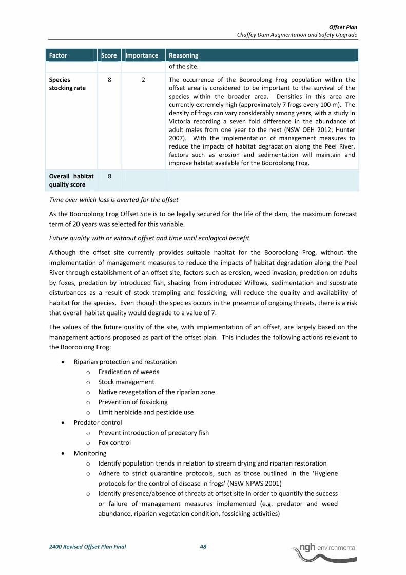
Offset Plan
Chaffey Dam Augmentation and Safety Upgrade
2400 Revised Offset Plan Final 48
Factor Score Importance Reasoning
of the site.
Species
stocking rate
8 2 The occurrence of the Booroolong Frog population within the
offset area is considered to be important to the survival of the
species within the broader area. Densities in this area are
currently extremely high (approximately 7 frogs every 100 m). The
density of frogs can vary considerably among years, with a study in
Victoria recording a seven fold difference in the abundance of
adult males from one year to the next (NSW OEH 2012; Hunter
2007). With the implementation of management measures to
reduce the impacts of habitat degradation along the Peel River,
factors such as erosion and sedimentation will maintain and
improve habitat available for the Booroolong Frog.
Overall habitat
quality score
8
Time over which loss is averted for the offset
As the Booroolong Frog Offset Site is to be legally secured for the life of the dam, the maximum forecast
term of 20 years was selected for this variable.
Future quality with or without offset and time until ecological benefit
Although the offset site currently provides suitable habitat for the Booroolong Frog, without the
implementation of management measures to reduce the impacts of habitat degradation along the Peel
River through establishment of an offset site, factors such as erosion, weed invasion, predation on adults
by foxes, predation by introduced fish, shading from introduced Willows, sedimentation and substrate
disturbances as a result of stock trampling and fossicking, will reduce the quality and availability of
habitat for the species. Even though the species occurs in the presence of ongoing threats, there is a risk
that overall habitat quality would degrade to a value of 7.
The values of the future quality of the site, with implementation of an offset, are largely based on the
management actions proposed as part of the offset plan. This includes the following actions relevant to
the Booroolong Frog:
• Riparian protection and restoration
o Eradication of weeds
o Stock management
o Native revegetation of the riparian zone
o Prevention of fossicking
o Limit herbicide and pesticide use
• Predator control
o Prevent introduction of predatory fish
o Fox control
• Monitoring
o Identify population trends in relation to stream drying and riparian restoration
o Adhere to strict quarantine protocols, such as those outlined in the ‘Hygiene
protocols for the control of disease in frogs’ (NSW NPWS 2001)
o Identify presence/absence of threats at offset site in order to quantify the success
or failure of management measures implemented (e.g. predator and weed
abundance, riparian vegetation condition, fossicking activities)
Offset Plan
Chaffey Dam Augmentation and Safety Upgrade
2400 Revised Offset Plan Final 49
It is considered reasonable that the overall quality of the habitat for the Booroolong Frog within the
Booroolong Frog Offset Site could be increased from a value of 8 to a value of 9 by implementing these
management actions.
The proposed management measures have been identified as objectives in the National Booroolong Frog
Recovery Plan (NWS OEH 2012). As the degradation at the site has been largely caused by stock access,
weed invasion and human disturbance (especially in relation to fossicking), and the management actions
described above are ensured to be carried out as part of a management plan, a confidence level of 80%
has been applied to the time until ecological benefit. This is considered reasonable as it still allows for
unforeseen circumstances such as extreme weather events, or unknown responses to those management
measures. The offset site management plan will comprise a series of adaptive management plans which
will be approved by OEH within six months of project approval and will allow the detection and response
to those factors.
A conservative estimate of five years has been given for the time until ecological benefit. The proposed
management measures will be incorporated prior to construction and while some of the measures will be
evident immediately (manage stock access), other measures will be evident over a longer timeframe
(riparian restoration, weed control). It is considered that it will take approximately five years for the
habitat quality improvement of the offset site to be realised.
Risk of loss of the offset site with or without the offset
The Booroolong Frog Offset Site is currently utilised as a watering point for stock and for recreational
activities including fossicking. The offset site is owned by multiple private landowners and is not
protected by any conservation agreements or reservation schemes. A number of Management
Agreements (MAs) currently exist between landholders and Namoi CMA for the offset site, however
evidence of the success of these management actions through monitoring and auditing is not publicly
available.
Field surveys indicate that these conditions are not being met sufficiently (Phil Spark, pers. comm.).
Furthermore, the current MAs can be terminated with one month notice. These MAs are due to expire in
five years (2018). The plan for the Booroolong Frog Offset Site is to assume management of the lands
subject to these MAs, continue to implement the current management actions, improve upon the current
management actions and carry out additional on-ground restoration works that are not currently being
undertaken.
The Conservation Agreement for a given property will be lodged with the Department of Lands and
registered on the certificate of land title for the property. Thus sale of a property would not endanger
the agreement.
The proposed management of the Booroolong Frog Offset Site detailed in this Offset Plan (Section 4) will
incorporate additional conditions subject to ongoing monitoring, thereby reducing the risk of loss of the
offset site. There are no known pending mining leases or development applications that apply to the
offset site.
As stated in the ‘How to use the Offsets Assessment Guide’, degradation to the quality of the site due to
current management practices and use should not be incorporated into the risk of loss as these factors
are incorporated in the quality score. However, it is considered reasonable that future land management
practices be taken into account. An estimate of 30% risk of loss without offset has been applied as the
site is unprotected, however, there is no indication that it is likely to be lost in the future.

Offset Plan
Chaffey Dam Augmentation and Safety Upgrade
2400 Revised Offset Plan Final 50
With the offset in place, the risk of loss is considered to be very low as the offset would be legally secured
for the life of the dam. There is a small chance that the offset may be lost due to unforeseen
circumstances. A 5% risk of loss has been applied to account for this.
Considering the extensive amount of field survey and time spent on assessing the site, a good
understanding of the site and associated land use pressures has been obtained. Furthermore, State
Water is a public entity with a strong environmental record. The estimated values for risk of loss are
considered to be reasonably informed; a 70% confidence in these results has been applied.
Results
Utilising the values described above, the OAG returned a 191.44% direct offset for the impact (included
as Appendix A). No additional compensatory measures are considered to be required.
3.1.2 Box-Gum grassy woodland CEEC
Approximately 7.38 ha of Box-Gum grassy woodland that meets the criteria for the EPBC listed CEEC will
be impacted by the development. As documented in the Terrestrial and Aquatic Flora and Fauna
Assessment, this impact will not be significant.
However, the proposed offset site contains approximately 207 ha of the community which variably meets
the EPBC criteria based on understorey diversity, the density of mature trees and the presence of
overstorey regeneration. The OAG was run using the above figures as detailed below.
Methods
The OAG was run as described above for the Booroolong Frog. As with the Booroolong Frog, a
conservative approach has been adopted. The reasoning used in reaching key values for each of the OAG
inputs is discussed individually for each below.
Quality of habitat to be impacted and the start quality of habitat at the offset site
The overall habitat quality score (0-10) was determined by considering the following factors (as outlined
in the ‘How to use the Offsets Assessment Guide’) individually:
• Site condition. Including vegetation condition (weediness), structure and species diversity.
• Site context. The biodiversity importance of the site in terms of its landscape position.
• Species stocking rate. The number of individual populations at the site.
The contribution of these factors was then weighted according to their level of importance to achieve an
overall habitat quality score. The results of this analysis are provided in the tables below (as the offset
site is immediately adjacent to the area to be impacted, the start quality of both areas was considered to
be the same.)
Table 3-3 Habitat quality of Box-Gum grassy woodland CEEC to be impacted by the development
Factor Score Importance Reasoning
Site condition 8 1 The area to be impacted north of the camping ground exhibits
quite a high diversity of native forbs. Weeds are common but not
prolific. The area south of the camping ground has a moderate
diversity and similar weediness. Overstorey regeneration was
evident in all areas. Areas of the community with a moderate to
high diversity within the development area are rare.
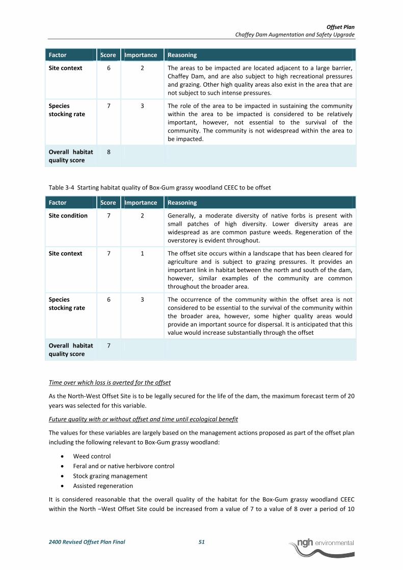
Offset Plan
Chaffey Dam Augmentation and Safety Upgrade
2400 Revised Offset Plan Final 51
Factor Score Importance Reasoning
Site context 6 2 The areas to be impacted are located adjacent to a large barrier,
Chaffey Dam, and are also subject to high recreational pressures
and grazing. Other high quality areas also exist in the area that are
not subject to such intense pressures.
Species
stocking rate
7 3 The role of the area to be impacted in sustaining the community
within the area to be impacted is considered to be relatively
important, however, not essential to the survival of the
community. The community is not widespread within the area to
be impacted.
Overall habitat
quality score
8
Table 3-4 Starting habitat quality of Box-Gum grassy woodland CEEC to be offset
Factor Score Importance Reasoning
Site condition 7 2 Generally, a moderate diversity of native forbs is present with
small patches of high diversity. Lower diversity areas are
widespread as are common pasture weeds. Regeneration of the
overstorey is evident throughout.
Site context 7 1 The offset site occurs within a landscape that has been cleared for
agriculture and is subject to grazing pressures. It provides an
important link in habitat between the north and south of the dam,
however, similar examples of the community are common
throughout the broader area.
Species
stocking rate
6 3 The occurrence of the community within the offset area is not
considered to be essential to the survival of the community within
the broader area, however, some higher quality areas would
provide an important source for dispersal. It is anticipated that this
value would increase substantially through the offset
Overall habitat
quality score
7
Time over which loss is averted for the offset
As the North-West Offset Site is to be legally secured for the life of the dam, the maximum forecast term of 20
years was selected for this variable.
Future quality with or without offset and time until ecological benefit
The values for these variables are largely based on the management actions proposed as part of the offset plan
including the following relevant to Box-Gum grassy woodland:
• Weed control
• Feral and or native herbivore control
• Stock grazing management
• Assisted regeneration
It is considered reasonable that the overall quality of the habitat for the Box-Gum grassy woodland CEEC
within the North –West Offset Site could be increased from a value of 7 to a value of 8 over a period of 10
Offset Plan
Chaffey Dam Augmentation and Safety Upgrade
2400 Revised Offset Plan Final 52
years by maintaining these management actions. Conversely, if current land management practices continue,
it is considered likely that the site would potentially degrade in quality predominately due to a continued loss
of diversity within the groundcover. Over the 10 year period it is considered likely that the overall habitat
quality would degrade to a value of 6.
As the degradation at the North-West Offset Site has been largely caused by weed invasion and grazing and
that the management actions described above are ensured to be carried out as part of a management plan for
the forecast period, a confidence level of 85% has been applied. This is considered reasonable as it still allows
for unforeseen circumstances such as extreme weather events.
Risk of loss of the offset site with or without the offset
The North-West Offset Site is currently utilised for grazing and is situated within a landscape where this is the
dominant land use. It is owned by State Water and leased to private landowners and not protected by any
conservation agreements or reservation schemes.
There are no known pending mining leases or development applications that apply to the offset site.
As stated in the ‘How to use the Offsets Assessment Guide’, degradation to the quality of the site due to
current management practices and use should not be incorporated into the risk of loss as these factors are
incorporated in the quality score, however, it is considered reasonable that future land management practices
be taken into account. Given the land is owned by State Water, it is considered unlikely that future land use
would lead to the loss of the offset site unless the site was sold, which must be considered as a possibility. An
estimate of 10% risk of loss without offset has been applied as the site is unprotected however it is considered
unlikely that it would be lost over the forecast term.
With the offset in place, the risk of loss is considered to be very low as the offset would be legally secured for
the life of the dam. There is a small chance that the offset may be lost due to unforeseen circumstances. A 5%
risk of loss has been applied to account for this.
Considering the extensive amount of field survey undertaken, a good understanding of the site and associated
land use pressures has been obtained. The estimated values for risk of loss are considered to be reasonably
informed, however, a conservative 70% confidence in these results has been applied.
Results
Utilising the values described above, the OAG returned a 304.18% direct offset for the impact (included
as Appendix B).
3.2 PRINCIPLES OF THE EPBC ACT EOP
In order to satisfy the EPBC Act EOP suitable offsets must:
Deliver an overall conservation outcome that improves or maintains the viability of the aspect of the
environment that is protected by national environment law and affected by the proposed action
Booroolong Frog
The Project will directly impact upon approximately 4.77 ha of Booroolong Frog habitat on the Peel River
(total area of river channel to be impacted). According to the EPBC Offset Assessment Guide (OAG), an
offset of 31.8 ha (or 9 km) of Booroolong Frog habitat will provide a 191% direct offset for the anticipated
impact to this species.

Offset Plan
Chaffey Dam Augmentation and Safety Upgrade
2400 Revised Offset Plan Final 53
There is 23.2 km upstream of the new FSL that is known habitat for the Booroolong Frog, within which
2235 individuals were recorded in summer 2013. It is proposed to establish an offset site immediately
upstream of the new FSL for a distance of 9 km (Figure 3-1).
Several allotments constitute the Booroolong Frog Offset Site as listed in Table 3-5. The allotments are
contiguous and the offset site is contiguous with the development site. The delineation of the offset site
for the Booroolong Frog is further discussed in Section 3.
Table 3-5 Allotments constituting the Booroolong Frog offset site (Lot and DPs supplied by Tamworth Regional
Council, 2013)
Lot DP Area (ha) Lot DP Area (ha)
10 1125418 216 1 744739 671
7317 1140215 1 297 40575 1
99 755335 1 304 705107 0.3
7008 1060952 6 2 595586 76
The proposed Booroolong Frog Offset Site which would provide a 191% direct offset (as calculated by the
OAG), contains Booroolong Frog habitat that is considered to be in similar condition to that to be
impacted.
Proposed management measures at the offset site will ensure that the long-term viability of Booroolong
Frog habitat at the site is maintained or improved. This can be confidently expected with measures such
as restoration and revegetation of the riparian zone, weed control, and stock management. These
actions are in response to known threats listed in the National Recovery Plan for the Booroolong Frog and
will reduce habitat degradation along the Peel River (NSW OEH 2012). Fossicking has also been identified
by Namoi CMA and OEH as a threat to the Booroolong Frog population along the Peel River (Anna Cronin
pers. comm.; David Coote pers. comm.). The Fossickers Way is a touring route in northern NSW which
promotes recreational activities such as fossicking. The southern part of the Fossickers Way incorporates
the Peel River between Tamworth and Nundle, which includes both the development site and proposed
offset site. Measures to discourage and/or promote responsible fossicking will be implemented,
adopting an adaptive approach in consultation with Namoi CMA.
White box-Yellow Box Blakely’s Red Gum Grassy Woodland CEEC
The Project will directly impact upon approximately 7.4 ha of vegetation considered to comprise the
CEEC. The proposed North – West Offset Site contains approximately 207 ha of vegetation considered to
comprise the CEEC in slightly lower condition to that to be impacted providing a 304% direct offset (as
calculated by the OAG). Proposed management measures at the offset site will ensure that the long-term
viability of the CEEC at the site is maintained or improved.
Be built around direct offsets but may include other compensatory measures
Booroolong Frog
The proposed offset site offers a 191% direct offset for Booroolong Frog habitat to be impacted by the
Project with funding to be provided via the Booroolong frog Recovery Program managed by OEH.
Management of the offset site will incorporate additional management measures to value-add to those
conditions already in place under the current MAs. Monitoring of the offset site will ensure compliance
with those management measures and allow for adaptive management.
Offset Plan
Chaffey Dam Augmentation and Safety Upgrade
2400 Revised Offset Plan Final 54
As a 191% direct offset will be achieved, no other compensatory measures are required in accordance
with the EPBC Act EOP.
White box-Yellow Box Blakely’s Red Gum Grassy Woodland CEEC
The proposed North – West offset site offers a 304% direct offset in terms of the same aspect of the
environment that is to be impacted (Box-Gum grassy woodland CEEC). A Conservation Agreement (CA)
or Conservation Property Vegetation Plan (CPVP) is proposed for securing the direct offset. Either the CA
or CPVP would be a legally binding agreement ensuring the site is secured for the life of the dam.
Be in proportion to the level of statutory protection that applies to the protected matter
Booroolong Frog
The offsets required for protected matters with higher conservation status must be greater than those
with a lower status. The “endangered” conservation status of the Booroolong Frog was used in the OAG,
to give an annual probability of extinction of 1.2%. This is an automated value in the OAG and is an
estimate of the average chance that a species or ecological community will be completely lost in the wild
each year, given recent rates of decline.
The proposed offset site provides a 191% direct offset for the endangered Booroolong Frog.
White box-Yellow Box Blakely’s Red Gum Grassy Woodland CEEC
The offsets required for protected matters with higher conservation status must be greater than those
with a lower status. The proposed offset site provides a direct offset for the CEEC and the same level of
statutory protection applies.
Be of a size and scale proportionate to the residual impacts on the protected matter
Booroolong Frog
A total of 9 km of Booroolong Frog habitat has been proposed that offers a 191% direct offset as
calculated by the OAG. According to the OAG the size and scale of the proposed offset is suitable.
White box-Yellow Box Blakely’s Red Gum Grassy Woodland CEEC
The proposed offset site offers a 304% direct offset as calculated by the OAG which confirms that the size
and scale of the offset is suitable. An offset is not required for this community under the EPBC Act EOP as
the Project will not have a significant impact on the community.
Effectively account for and manage the risks of the offset not succeeding
Booroolong Frog
The proposed offset site provides a 191% direct offset. It is recognised in the EOP that direct offsets
present a lower risk than other compensatory measures as they are more likely to result in a
conservation gain for a protected matter. The direct offset will be managed in perpetuity for biodiversity
under a legally binding agreement which provides surety of the offset succeeding for the long-term. An
adaptive management plan will be incorporated into the management of the offset site. The Plan will be
prepared in close consultation with OEH and approved within 6 months of Project approval. This will
ensure that the results of offset site monitoring will guide and improve management over the long-term.
Offset Plan
Chaffey Dam Augmentation and Safety Upgrade
2400 Revised Offset Plan Final 55
White box-Yellow Box Blakely’s Red Gum Grassy Woodland
The proposed offset site provides a 304% direct offset. It is recognised in the EOP that direct offsets
present a lower risk than other compensatory measures as they are more likely to result in a
conservation gain for a protected matter. The direct offset will be managed in perpetuity for biodiversity
under a legally binding agreement which provides surety of the offset succeeding for the long-term.
Be additional to what is already required, determined by law or planning regulations or agreed to
under other schemes or programs (this does not preclude the recognition of state or territory offsets
that may be suitable as offsets under the EPBC Act for the same action, see section 7.6)
Booroolong Frog
The Booroolong Frog Offset Site provides a 191% direct offset for Booroolong Frog habitat on a like for
like basis. Management of the offset site will incorporate additional measures to those set out by the
current MAs. The establishment of Conservation Agreements will ensure the long-term and effective
management and protection of the offset site. Under the current MAs, the offset site is subject to
residual threats and is not being managed effectively. Furthermore, these MAs can be terminated with
one month notice. The offset site will count toward the offset required under the TSC Act for River Oak
riparian woodland of the Brigalow Belt South and Nandewar Bioregions. No additional compensatory
measures are considered to be required to account for any residual impact to Booroolong Frog habitat on
the Peel River.
White box-Yellow Box Blakely’s Red Gum Grassy Woodland
This Offset Plan has been produced incorporating the BioBanking methodology which is a methodology
endorsed by the NSW OEH. As stated in the EOP, a state or territory offset will count toward an offset
under the EPBC Act to the extent that it compensates for the residual impact to the protected matter
identified under the EPBC Act. The offset site provides a 304% direct offset for the CEEC on a like for like
basis.
However, it should be noted that although an offset is not required for this community, this Offset Plan
does meet the requirements of an offset site according to the EPBC EOP.
Be efficient, effective, timely, transparent, scientifically robust and reasonable
Booroolong Frog
The proposed Booroolong Frog Offset Site has been determined in accordance with the requirements of
the NSW OEH and EPBC EOP. The Offset Plan will be effective, and will be implemented prior to and
during the impact arising from the action. Timeframes and responsibilities for implementation of
management actions as well as monitoring and auditing requirements will be outlined in the approved
Offset site Management Plan. The plan will be adaptive, in order to guide and improve management over
the long-term. Management plans will be prepared in consultation with OEH and Namoi CMA and will be
approved by OEH. The Booroolong Frog Offset Site will be protected for the life of the dam. Proposed
management measures for the offset site are based on input from Booroolong Frog experts and taking
into account local knowledge, as well as the objectives of the National Recovery Plan for the Booroolong
Frog (NSW OEH 2012). Management measures will therefore be efficient and effective they are designed
to reduce known threats operating on the target species on the offset site.
Offset Plan
Chaffey Dam Augmentation and Safety Upgrade
2400 Revised Offset Plan Final 56
White box-Yellow Box Blakely’s Red Gum Grassy Woodland CEEC
An Offset Plan has been prepared in accordance with the requirements of the NSW OEH. This Offset Plan
is not required to satisfy the direct offset requirements of the EPBC EOP for this community.
The Offset Plan will be effective, being implemented immediately after the impact arising from the
action.
Have transparent governance arrangements including being able to be readily measured, monitored,
audited and enforced.
Booroolong Frog
A funding agreement is recommended for securing and managing the direct offset. This ensures that the
management measures for the frog are implemented for the life of the dam.
During the operational life of the dam, the management and maintenance of the offset site will be
auditable through the Project’s Offset Site Management Plan which will detail monitoring and reporting
requirements (Section 4).
White box-Yellow Box Blakely’s Red Gum Grassy Woodland CEEC
A CA or CPVP is proposed within this Offset Plan for securing and managing the direct offset. This
ensures that the site is protected for the life of the dam and that restrictions on land use that apply will
be attached to the title, as will management measures.
During the operational life of the dam, the management and maintenance of the offset site will be
auditable through the project’s Offset Site Management Plan which will detail monitoring and reporting
requirements.
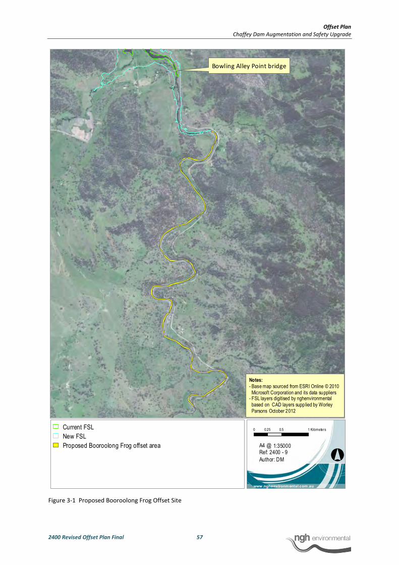
Offset Plan
Chaffey Dam Augmentation and Safety Upgrade
2400 Revised Offset Plan Final 57
Figure 3-1 Proposed Booroolong Frog Offset Site
°
0 0.5 10.25 Kilometers
1:35000
www.nghenvironmental.com.au
A4 @ Ref: 2400 - 9
Author: DM
Notes:
- Base map sourced from ESRI Online © 2010
Microsoft Corporation and its data suppliers- FSL layers digitised by nghenvironmental
based on CAD layers supplied by Worley
Parsons October 2012
Current FSL
New FSL
Proposed Booroolong Frog offset area
Bowling Alley Point bridge

Offset Plan
Chaffey Dam Augmentation and Safety Upgrade
2400 Revised Offset Plan Final 58
4 SECURITY AND MANAGEMENT OF THE OFFSET
SITES
4.1 MANAGEMENT VEHICLES
An appropriate management vehicle is required that:
• Secures the site in perpetuity
• Allows for the ongoing management of the site (including how the designated management
actions will be funded)
The following six options are considered by OEH as being suitable and acceptable for securing an offset
site in perpetuity as outlined in the OEH Guidance on Appropriate Mechanisms for Securing Biodiversity
Offsets document. Note that option 6 (a CPVP) is only considered acceptable where the first five are not
able to be negotiated:
1. BioBanking agreement, a system set up by OEH and offering the most security in terms of
ongoing management outcomes
2. Dedication to the public reserve system
3. Conservation Agreement (CA)
4. Trust agreement
5. Planning Agreement
6. Conservation Property Vegetation Plan (CPVP)
7. Incentive funding
4.2 PROPOSED NORTH-WEST OFFSET SITE (AS ASSESSED USING THE
BBAM)
It is proposed that a CA will be established over the North-West Offset Site and that it will be attached to
the land titles. To ensure that the CA is binding on successors in title, an abstract of the CA will be
registered with the Land and Property Management Authority under the Real Property Act 1900.
The CA will be a legally binding agreement under relevant Acts and will include management actions
associated with the offset area that will apply for the life of the dam. These management actions should
be consistent with recommendations specified in this document.
As a CA is attached to the land title, the land owner (currently State Water) is ultimately responsible for
funding the management actions required at the offset site and monitoring the effectiveness of their
implementation. State Water, as the owner of the site will hold this responsibility.
4.2.1 North-West Offset Site Management Plan
The BCC recommends specific management measures as they apply to each vegetation zone within an
assessment. The requirements for the proposed offset site were returned by the offset credit statement
(Appendix A) for all vegetation zones as follows:
• Cat and/or fox control

Offset Plan
Chaffey Dam Augmentation and Safety Upgrade
2400 Revised Offset Plan Final 59
• Exclusion of miscellaneous feral species
• Feral and /or native herbivore control/exclusion (e.g. rabbits, goats, deer etc)
These management measures would be incorporated into a detailed management plan for the offset site.
In addition, the following measures would also be undertaken:
• Restriction of public access including fencing and signage
• Weed control (several noxious weeds are widespread across the offset site)
• Management of stock grazing for conservation purposes (this would be conducted in
consultation with a local agronomist)
• Assisted regeneration of cleared areas by either stock exclusion or strategic rehabilitation
including plantings
• Implementation of controlled burns
The management plan would be prepared and be ready for implementation with the establishment of
the offset site. A summary of the proposed management measures, their justification, proposed actions
and monitoring are provided in Table 4-1. All management measures are the responsibility of State
Water.
For each of the measures described, the detailed management plan for the site would:
• Describe the existing situation
• Detail the proposed management measure including
o Specific locations where management is required
o The objectives of the management
o The proposed actions to achieve the objectives
o Identify persons responsible
o Estimated costs and timeframes
• Proposed monitoring regime
• Reporting requirements
At the end of the operational life of the dam, the ongoing management would be the responsibility of the
landowner. It is expected that by this time the majority of the required management actions would have
been undertaken and ongoing management tasks will largely coincide with routine agricultural activities.
Land use restrictions will remain in place on the offset site so that any activities undertaken on the offset
site must be compatible with the site’s overall function: to improve biodiversity values.
For the duration of the project, the success of the management actions would be audited and reported as
part of an annual environmental report to OEH for the project.
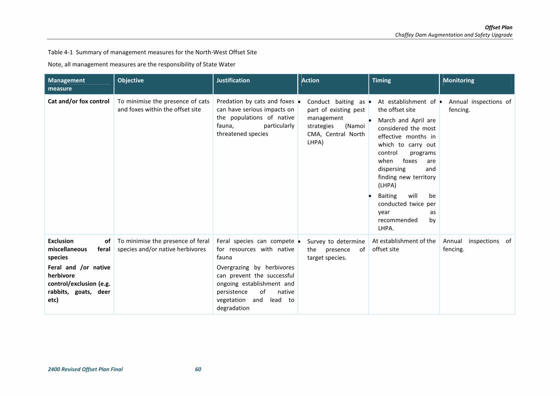
Offset Plan
Chaffey Dam Augmentation and Safety Upgrade
2400 Revised Offset Plan Final 60
Table 4-1 Summary of management measures for the North-West Offset Site
Note, all management measures are the responsibility of State Water
Management
measure
Objective Justification Action Timing Monitoring
Cat and/or fox control To minimise the presence of cats
and foxes within the offset site
Predation by cats and foxes
can have serious impacts on
the populations of native
fauna, particularly
threatened species
• Conduct baiting as
part of existing pest
management
strategies (Namoi
CMA, Central North
LHPA)
• At establishment of
the offset site
• March and April are
considered the most
effective months in
which to carry out
control programs
when foxes are
dispersing and
finding new territory
(LHPA)
• Baiting will be
conducted twice per
year as
recommended by
LHPA.
• Annual inspections of
fencing.
Exclusion of
miscellaneous feral
species
Feral and /or native
herbivore
control/exclusion (e.g.
rabbits, goats, deer
etc)
To minimise the presence of feral
species and/or native herbivores
Feral species can compete
for resources with native
fauna
Overgrazing by herbivores
can prevent the successful
ongoing establishment and
persistence of native
vegetation and lead to
degradation
• Survey to determine
the presence of
target species.
At establishment of the
offset site
Annual inspections of
fencing.
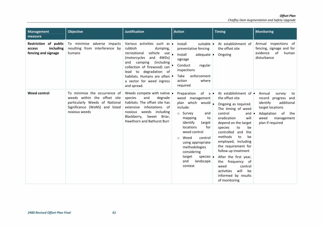
Offset Plan
Chaffey Dam Augmentation and Safety Upgrade
2400 Revised Offset Plan Final 61
Management
measure
Objective Justification Action Timing Monitoring
Restriction of public
access including
fencing and signage
To minimise adverse impacts
resulting from interference by
humans
Various activities such as
rubbish dumping,
recreational vehicle use
(motorcycles and 4WDs)
and camping (including
collection of firewood) can
lead to degradation of
habitats. Humans are often
a vector for weed ingress
and spread.
• Install suitable
preventative fencing
• Install adequate
signage
• Conduct regular
inspections
• Take enforcement
action where
required
• At establishment of
the offset site
• Ongoing
Annual inspections of
fencing, signage and for
evidence of human
disturbance
Weed control To minimise the occurrence of
weeds within the offset site
particularly Weeds of National
Significance (WoNS) and listed
noxious weeds
Weeds compete with native
species and degrade
habitats. The offset site has
extensive infestations of
noxious weeds including
Blackberry, Sweet Briar,
Hawthorn and Bathurst Burr
• Preparation of a
weed management
plan which would
include:
o Survey and
mapping to
identify target
locations for
weed control
o Weed control
using appropriate
methodologies
considering
target species
and landscape
context
• At establishment of
the offset site
• Ongoing as required.
The timing of weed
control and
eradication will
depend on the target
species to be
controlled and the
methods to be
employed, including
the requirement for
follow up treatment
• After the first year,
the frequency of
weed control
activities will be
informed by results
of monitoring
• Annual survey to
record progress and
identify additional
target locations
• Adaptation of the
weed management
plan if required

Offset Plan
Chaffey Dam Augmentation and Safety Upgrade
2400 Revised Offset Plan Final 62
Management
measure
Objective Justification Action Timing Monitoring
Management of stock
grazing for
conservation
purposes
To prevent overgrazing and
encourage the regeneration of
native vegetation
Strategic grazing can be utilised
for a number of benefits
including:
- Intermittent grazing to control
biomass and open up inter-
tussock spaces to allow for the
colonisation of native forbs
- Timing of grazing to control
particular target weed species
- Timing of grazing to promote
successful overstorey
regeneration
The proposed offset site has
a history of grazing, with
some areas (particularly the
lower slopes) more
intensively grazed than
others. The sudden
cessation of grazing may
result in detrimental effects
in these areas including the
vigorous growth of weeds or
tall tussock grasses that may
smother the growth or
prevent the colonisation of
other native species.
Proper stock grazing
management can control
weeds and assist in the
recovery of previously
heavily grazed areas.
• Prepare a grazing
management plan in
consultation with a
qualified local
agronomist
• Ensure any lease
holders comply with
the plan
• At establishment of
the offset site
• Ongoing
Annual inspection by a
qualified agronomist and
subsequent modification
of the plan if required.

Offset Plan
Chaffey Dam Augmentation and Safety Upgrade
2400 Revised Offset Plan Final 63
Management
measure
Objective Justification Action Timing Monitoring
Assisted regeneration
of cleared areas by
either stock exclusion
or strategic
rehabilitation
including plantings
To rehabilitate previously cleared
areas (particularly those derived
from EECs) to be representative
of the original vegetation
Much of the cleared areas
have resulted from clearing
an EEC. Re-establishment of
the overstorey in these
areas will contribute to the
conservation of this
community and provide
connectivity and habitats for
threatened flora and fauna.
• Prepare a vegetation
management plan
which would include
measures to:
• Strategically exclude
stock from areas that
are naturally
regenerating
• Conduct
rehabilitation
plantings in more
heavily grazed areas
where regeneration
has been suppressed
• Integrate the grazing
management plan
• At establishment of
the offset site
• Ongoing
• Annual inspections of
naturally regenerating
areas
• Regular monitoring
and adaptive
management of
planted areas as
required by the
vegetation
management plan
Implementation of
controlled burns
To re-introduce a more natural
fire regime and assist in the
recovery of degraded areas
Fire is an integral part of the
Australian landscape. Many
plant species depend on it
for successful germination.
Fire can also assist in
maintaining the balance of
species within an ecosystem
• Prepare a fire
management plan in
conjunction with an
ecologist and the
local RFS
• Conduct burns as per
the plan
• At establishment of
the offset site
• Ongoing
As required by the fire
management plan
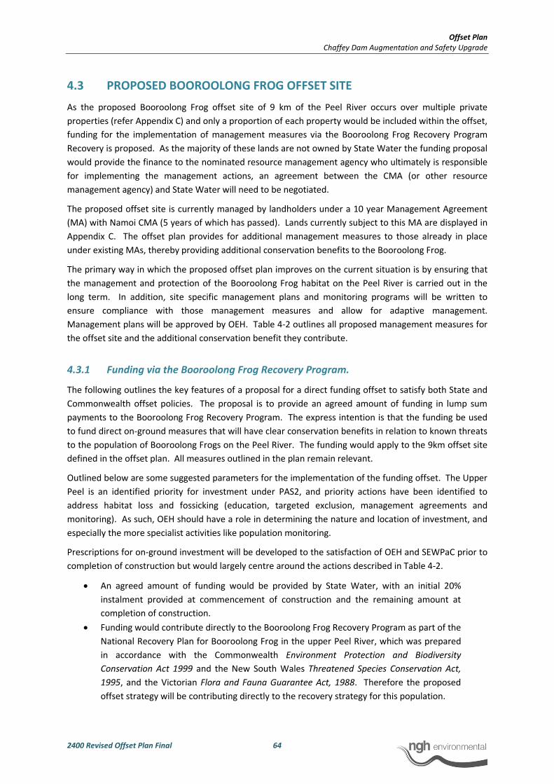
Offset Plan
Chaffey Dam Augmentation and Safety Upgrade
2400 Revised Offset Plan Final 64
4.3 PROPOSED BOOROOLONG FROG OFFSET SITE
As the proposed Booroolong Frog offset site of 9 km of the Peel River occurs over multiple private
properties (refer Appendix C) and only a proportion of each property would be included within the offset,
funding for the implementation of management measures via the Booroolong Frog Recovery Program
Recovery is proposed. As the majority of these lands are not owned by State Water the funding proposal
would provide the finance to the nominated resource management agency who ultimately is responsible
for implementing the management actions, an agreement between the CMA (or other resource
management agency) and State Water will need to be negotiated.
The proposed offset site is currently managed by landholders under a 10 year Management Agreement
(MA) with Namoi CMA (5 years of which has passed). Lands currently subject to this MA are displayed in
Appendix C. The offset plan provides for additional management measures to those already in place
under existing MAs, thereby providing additional conservation benefits to the Booroolong Frog.
The primary way in which the proposed offset plan improves on the current situation is by ensuring that
the management and protection of the Booroolong Frog habitat on the Peel River is carried out in the
long term. In addition, site specific management plans and monitoring programs will be written to
ensure compliance with those management measures and allow for adaptive management.
Management plans will be approved by OEH. Table 4-2 outlines all proposed management measures for
the offset site and the additional conservation benefit they contribute.
4.3.1 Funding via the Booroolong Frog Recovery Program.
The following outlines the key features of a proposal for a direct funding offset to satisfy both State and
Commonwealth offset policies. The proposal is to provide an agreed amount of funding in lump sum
payments to the Booroolong Frog Recovery Program. The express intention is that the funding be used
to fund direct on-ground measures that will have clear conservation benefits in relation to known threats
to the population of Booroolong Frogs on the Peel River. The funding would apply to the 9km offset site
defined in the offset plan. All measures outlined in the plan remain relevant.
Outlined below are some suggested parameters for the implementation of the funding offset. The Upper
Peel is an identified priority for investment under PAS2, and priority actions have been identified to
address habitat loss and fossicking (education, targeted exclusion, management agreements and
monitoring). As such, OEH should have a role in determining the nature and location of investment, and
especially the more specialist activities like population monitoring.
Prescriptions for on-ground investment will be developed to the satisfaction of OEH and SEWPaC prior to
completion of construction but would largely centre around the actions described in Table 4-2.
• An agreed amount of funding would be provided by State Water, with an initial 20%
instalment provided at commencement of construction and the remaining amount at
completion of construction.
• Funding would contribute directly to the Booroolong Frog Recovery Program as part of the
National Recovery Plan for Booroolong Frog in the upper Peel River, which was prepared
in accordance with the Commonwealth Environment Protection and Biodiversity
Conservation Act 1999 and the New South Wales Threatened Species Conservation Act,
1995, and the Victorian Flora and Fauna Guarantee Act, 1988. Therefore the proposed
offset strategy will be contributing directly to the recovery strategy for this population.
Offset Plan
Chaffey Dam Augmentation and Safety Upgrade
2400 Revised Offset Plan Final 65
• Funding would be provided via a Catchment Management Authority or any other
approved resource management body and administered by that body.
• NSW OEH lead the recovery program for the species and must retain a concurrence role in
determining priorities for expenditure of the funding.
• Obligation to comply with consent conditions remains with State Water.
• Funding provided under the Booroolong Frog Offset Plan must contribute specifically and
directly to on-ground management measures that will have a measureable positive
conservation benefit to the Booroolong Frog in the Upper Peel River.
• Funding may contribute to education programs where approved by OEH and specifically in
relation to raising the profile of the endangered Booroolong Frog and / or discouraging
fossicking in important habitats for the species. This would be considered an indirect
offset and would therefore constitute a maximum of 10% of the offset package funding
according to the EPBC Act Environmental Offsets Policy.
• The funding will provide for monitoring and reporting of the Booroolong Frog population
on the Upper Peel River for the duration of impact (life of Chaffey Dam).
• The funding may be used to implement management actions upstream of the area
currently managed by Namoi CMA, so that over time, the conservation benefit of the
funded management actions can be expanded, if conditions a) and b) have been met.
a) Monitoring results demonstrate that the Peel River population of the Booroolong
Frog has recovered to the extent that intervention and management are no
longer required in the Offset area, as agreed by Commonwealth and State
Government agencies, Catchment Management Authority, and independent
experts with specific knowledge of the species; and
b) The threats known to be operating on the Upper Peel River population of the
Booroolong Frog at commencement of funding are shown to no longer be
operating on the population.
• Allocation of the funds per management task will be guided by OEH.
4.4 MANAGEMENT AND MONITORING PLAN BOOROOLONG FROG
OFFSET
Management measures and monitoring proposed for the Booroolong Frog offset site are provided in
Table 4-1. The measures have been recommended in consideration of the National Recovery Plan for the
Booroolong Frog, recommendations in NWES (2009), and following consultation with Booroolong Frog
experts from OEH and Namoi CMA.
The National Recovery Plan lists 5 threats that are contributing to the decline of the Booroolong Frog.
They include:
• Disease
• Habitat Degradation
• Stream Drying
• Predation by Exotic Predatory Fish
• Herbicide Use
The OEH profile for the Booroolong Frog lists ten threats contributing to the decline of the species:
Offset Plan
Chaffey Dam Augmentation and Safety Upgrade
2400 Revised Offset Plan Final 66
• Modification of stream channels and loss of cobble banks;
• Loss of native streamside vegetation;
• Damage to stream margins by stock;
• Predation of eggs and tadpoles by introduced fish;
• Weed invasion of streamside habitats, particularly by willows;
• Disease - chytrid fungus;
• Changes to water quality through sedimentation and use of herbicides or pesticides near
streams;
• Stream drying caused by severe drought or water extraction/impoundment;
• Large amounts of sedimentation due to wild horse activity in the National Park, causing
filling of breeding crevices;
• High density of fossicking and in particular the illegal use of powered sluices and
deliberate damming of stretches to facilitate use.
Following consultation with David Coote and David Hunter of OEH, and Anna Cronin of Namoi CMA,
those threats listed in bold will be prioritised through the implementation of the management and
monitoring measures outlined in Table 4-2, thereby contributing to the recovery of the Booroolong Frog
in the Namoi Catchment.
Table 4-3 provides a comparison of the existing measures under the Management Agreements between
land holders and the Namoi CMA and how the proposed offset plan provides additional conservation
benefit. Management Conditions under the existing management Agreements are provided in Appendix
C.
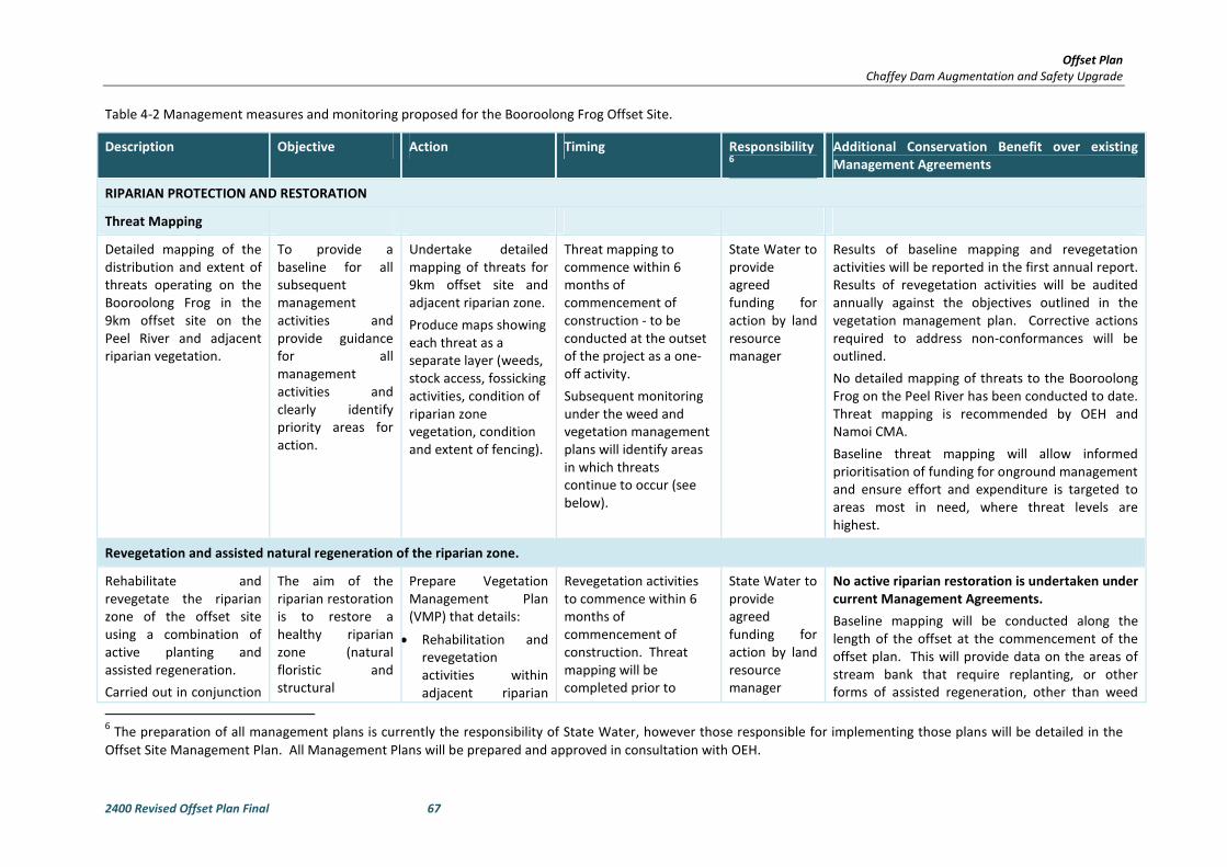
Offset Plan
Chaffey Dam Augmentation and Safety Upgrade
2400 Revised Offset Plan Final 67
Table 4-2 Management measures and monitoring proposed for the Booroolong Frog Offset Site.
Description Objective Action Timing Responsibility6
Additional Conservation Benefit over existing
Management Agreements
RIPARIAN PROTECTION AND RESTORATION
Threat Mapping
Detailed mapping of the
distribution and extent of
threats operating on the
Booroolong Frog in the
9km offset site on the
Peel River and adjacent
riparian vegetation.
To provide a
baseline for all
subsequent
management
activities and
provide guidance
for all
management
activities and
clearly identify
priority areas for
action.
Undertake detailed
mapping of threats for
9km offset site and
adjacent riparian zone.
Produce maps showing
each threat as a
separate layer (weeds,
stock access, fossicking
activities, condition of
riparian zone
vegetation, condition
and extent of fencing).
Threat mapping to
commence within 6
months of
commencement of
construction - to be
conducted at the outset
of the project as a one-
off activity.
Subsequent monitoring
under the weed and
vegetation management
plans will identify areas
in which threats
continue to occur (see
below).
State Water to
provide
agreed
funding for
action by land
resource
manager
Results of baseline mapping and revegetation
activities will be reported in the first annual report.
Results of revegetation activities will be audited
annually against the objectives outlined in the
vegetation management plan. Corrective actions
required to address non-conformances will be
outlined.
No detailed mapping of threats to the Booroolong
Frog on the Peel River has been conducted to date.
Threat mapping is recommended by OEH and
Namoi CMA.
Baseline threat mapping will allow informed
prioritisation of funding for onground management
and ensure effort and expenditure is targeted to
areas most in need, where threat levels are
highest.
Revegetation and assisted natural regeneration of the riparian zone.
Rehabilitate and
revegetate the riparian
zone of the offset site
using a combination of
active planting and
assisted regeneration.
Carried out in conjunction
The aim of the
riparian restoration
is to restore a
healthy riparian
zone (natural
floristic and
structural
Prepare Vegetation
Management Plan
(VMP) that details:
• Rehabilitation and
revegetation
activities within
adjacent riparian
Revegetation activities
to commence within 6
months of
commencement of
construction. Threat
mapping will be
completed prior to
State Water to
provide
agreed
funding for
action by land
resource
manager
No active riparian restoration is undertaken under
current Management Agreements.
Baseline mapping will be conducted along the
length of the offset at the commencement of the
offset plan. This will provide data on the areas of
stream bank that require replanting, or other
forms of assisted regeneration, other than weed
6 The preparation of all management plans is currently the responsibility of State Water, however those responsible for implementing those plans will be detailed in the
Offset Site Management Plan. All Management Plans will be prepared and approved in consultation with OEH.

Offset Plan
Chaffey Dam Augmentation and Safety Upgrade
2400 Revised Offset Plan Final 68
Description Objective Action Timing Responsibility6
Additional Conservation Benefit over existing
Management Agreements
with weed control
activities and stock
management (see below).
composition) that
will provide a
functional
ecological buffer to
the in-stream
environment. This
will reduce erosion
and sediment
impacts to the
stream, improve
water quality and
provided a natural
deterrent to stock
and human access.
zone. Assisted
natural regeneration
will include weed
removal. Plantings
will be saplings of
species naturally
occurring with thin
the riparian zone.
• Establish a minimum
of 2 20m x 20m
monitoring plots per
1 km of offset site (1
per bank).
• Monitoring will be
conducted annually
to measure
restoration success.
• Monitoring results
will be reported
annually and will
outline corrective
actions required.
finalisation of VMP.
Expenditure of funding
contributions to riparian
restoration will reduce
over time as riparian
vegetation establishes.
removal and control.
This constitutes one of the most important
recovery actions for the conservation of the
Booroolong Frog (Action 3.1, NSW OEH 2012)
Recommended by Phil Spark (NWES 2009) and
David Coote (OEH).
Active revegetation will increase the extent and
rate of recovery of riparian vegetation, which will
have a direct positive impact on stream health and
Booroolong Frog habitat.
Restoration of the riparian zone will enhance the
overall habitat quality of the in-stream
environment by improving the natural buffering
and filtration role of the riparian area for the
stream. It will also have the effect of deterring
human and vehicular access to the stream, thus
reducing the threats of trampling, sedimentation
and erosion and spread of chytrid.
Weed control
Control and eradicate
exotic trees and shrubs,
and other environmental
weeds, which have the
potential to dominate the
riparian zone (e.g.
Willows, Blackberry).
Weeds, particularly large
To assist with the
restoration of the
riparian zone (as
above).
For large woody
weeds such as
willow, this will
reduce any
Prepare Vegetation
Management Plan
(VMP) detailing:
• Areas and species
requiring weed
control, as per
results of baseline
threat mapping.
Baseline weed surveys
(threat mapping) will be
conducted along the
length of the offset site
within six months of
commencement of
construction. This will
allow identification and
prioritisation of control
State Water to
provide
agreed
funding for
action by land
resource
manager
No data is publicly available on extent to which
weeds have been brought under control, which
species and in what areas. According to Anna
Cronin of Namoi CMA, woody weed control has
been successful, but needs to be ongoing. Under
the proposed offset plan results of weed control
will be monitored and reported at a minimum
annually. Over time the cumulative benefits of
weed control will result in improved habitat quality
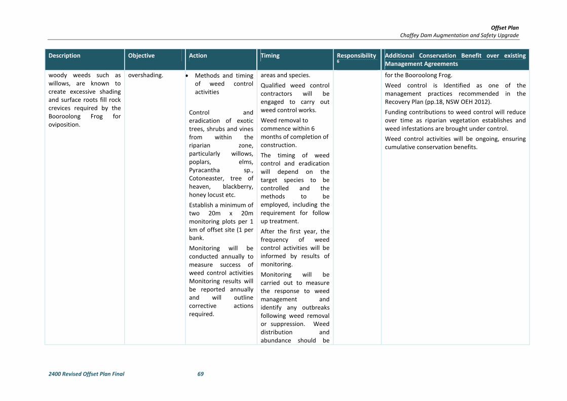
Offset Plan
Chaffey Dam Augmentation and Safety Upgrade
2400 Revised Offset Plan Final 69
Description Objective Action Timing Responsibility6
Additional Conservation Benefit over existing
Management Agreements
woody weeds such as
willows, are known to
create excessive shading
and surface roots fill rock
crevices required by the
Booroolong Frog for
oviposition.
overshading. • Methods and timing
of weed control
activities
Control and
eradication of exotic
trees, shrubs and vines
from within the
riparian zone,
particularly willows,
poplars, elms,
Pyracantha sp.,
Cotoneaster, tree of
heaven, blackberry,
honey locust etc.
Establish a minimum of
two 20m x 20m
monitoring plots per 1
km of offset site (1 per
bank.
Monitoring will be
conducted annually to
measure success of
weed control activities
Monitoring results will
be reported annually
and will outline
corrective actions
required.
areas and species.
Qualified weed control
contractors will be
engaged to carry out
weed control works.
Weed removal to
commence within 6
months of completion of
construction.
The timing of weed
control and eradication
will depend on the
target species to be
controlled and the
methods to be
employed, including the
requirement for follow
up treatment.
After the first year, the
frequency of weed
control activities will be
informed by results of
monitoring.
Monitoring will be
carried out to measure
the response to weed
management and
identify any outbreaks
following weed removal
or suppression. Weed
distribution and
abundance should be
for the Booroolong Frog.
Weed control is Identified as one of the
management practices recommended in the
Recovery Plan (pp.18, NSW OEH 2012).
Funding contributions to weed control will reduce
over time as riparian vegetation establishes and
weed infestations are brought under control.
Weed control activities will be ongoing, ensuring
cumulative conservation benefits.
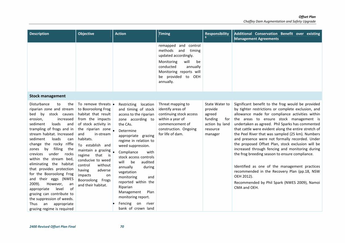
Offset Plan
Chaffey Dam Augmentation and Safety Upgrade
2400 Revised Offset Plan Final 70
Description Objective Action Timing Responsibility6
Additional Conservation Benefit over existing
Management Agreements
remapped and control
methods and timing
updated accordingly.
Monitoring will be
conducted annually
Monitoring reports will
be provided to OEH
annually.
Stock management
Disturbance to the
riparian zone and stream
bed by stock causes
erosion, increased
sediment loads and
trampling of frogs and in
stream habitat. Increased
sediment loads can
change the rocky riffle
zones by filling the
crevices under rocks
within the stream bed,
eliminating the habitat
that provides protection
for the Booroolong Frog
and their eggs (NWES
2009). However, an
appropriate level of
grazing can contribute to
the suppression of weeds.
Thus an appropriate
grazing regime is required
To remove threats
to Booroolong Frog
habitat that result
from the impacts
of stock activity in
the riparian zone
and in-stream
habitats.
To establish and
maintain a grazing
regime that is
conducive to weed
control without
having adverse
impacts on
Booroolong Frogs
and their habitat.
• Restricting location
and timing of stock
access to the riparian
zone according to
the CAs.
• Determine
appropriate grazing
regime in relation to
weed suppression.
• Compliance with
stock access controls
will be audited
annually during
vegetation
monitoring and
reported within the
Riparian
Management Plan
monitoring report.
• Fencing on river
bank of crown land
Threat mapping to
identify areas of
continuing stock access
within a year of
commencement of
construction. Ongoing
for life of dam.
State Water to
provide
agreed
funding for
action by land
resource
manager
Significant benefit to the frog would be provided
by tighter restrictions or complete exclusion, and
allowance made for compliance activities within
the areas to ensure stock management is
undertaken as agreed. Phil Sparks has commented
that cattle were evident along the entire stretch of
the Peel River that was sampled (25 km). Numbers
and presence were not formally recorded. Under
the proposed Offset Plan, stock exclusion will be
increased through fencing and monitoring during
the frog breeding season to ensure compliance.
Identified as one of the management practices
recommended in the Recovery Plan (pp.18, NSW
OEH 2012).
Recommended by Phil Spark (NWES 2009), Namoi
CMA and OEH.
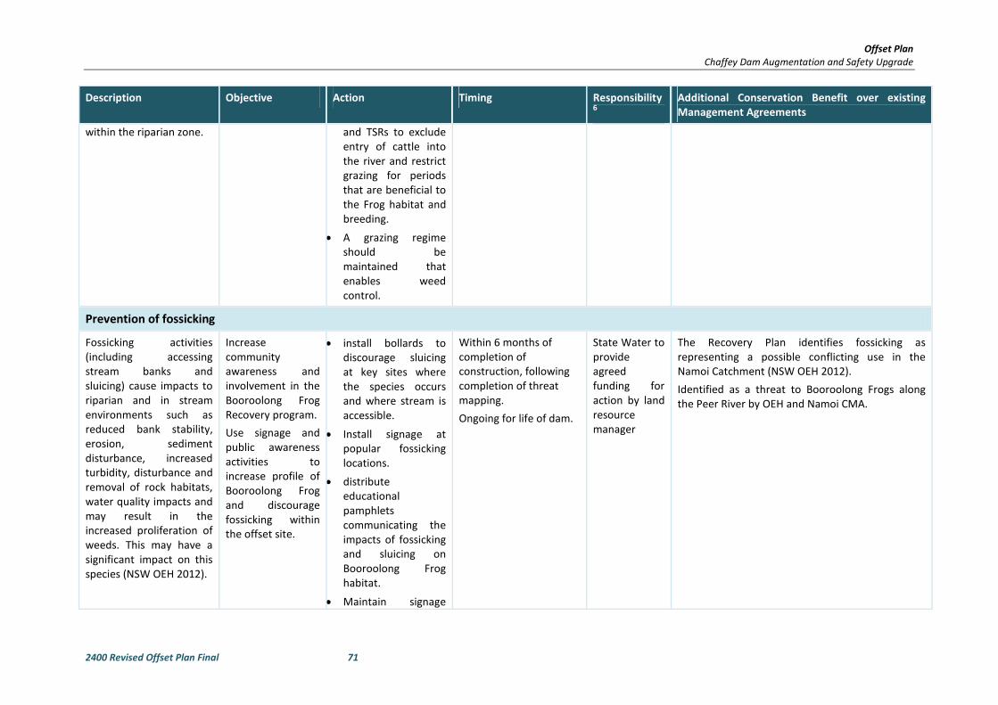
Offset Plan
Chaffey Dam Augmentation and Safety Upgrade
2400 Revised Offset Plan Final 71
Description Objective Action Timing Responsibility6
Additional Conservation Benefit over existing
Management Agreements
within the riparian zone. and TSRs to exclude
entry of cattle into
the river and restrict
grazing for periods
that are beneficial to
the Frog habitat and
breeding.
• A grazing regime
should be
maintained that
enables weed
control.
Prevention of fossicking
Fossicking activities
(including accessing
stream banks and
sluicing) cause impacts to
riparian and in stream
environments such as
reduced bank stability,
erosion, sediment
disturbance, increased
turbidity, disturbance and
removal of rock habitats,
water quality impacts and
may result in the
increased proliferation of
weeds. This may have a
significant impact on this
species (NSW OEH 2012).
Increase
community
awareness and
involvement in the
Booroolong Frog
Recovery program.
Use signage and
public awareness
activities to
increase profile of
Booroolong Frog
and discourage
fossicking within
the offset site.
• install bollards to
discourage sluicing
at key sites where
the species occurs
and where stream is
accessible.
• Install signage at
popular fossicking
locations.
• distribute
educational
pamphlets
communicating the
impacts of fossicking
and sluicing on
Booroolong Frog
habitat.
• Maintain signage
Within 6 months of
completion of
construction, following
completion of threat
mapping.
Ongoing for life of dam.
State Water to
provide
agreed
funding for
action by land
resource
manager
The Recovery Plan identifies fossicking as
representing a possible conflicting use in the
Namoi Catchment (NSW OEH 2012).
Identified as a threat to Booroolong Frogs along
the Peer River by OEH and Namoi CMA.
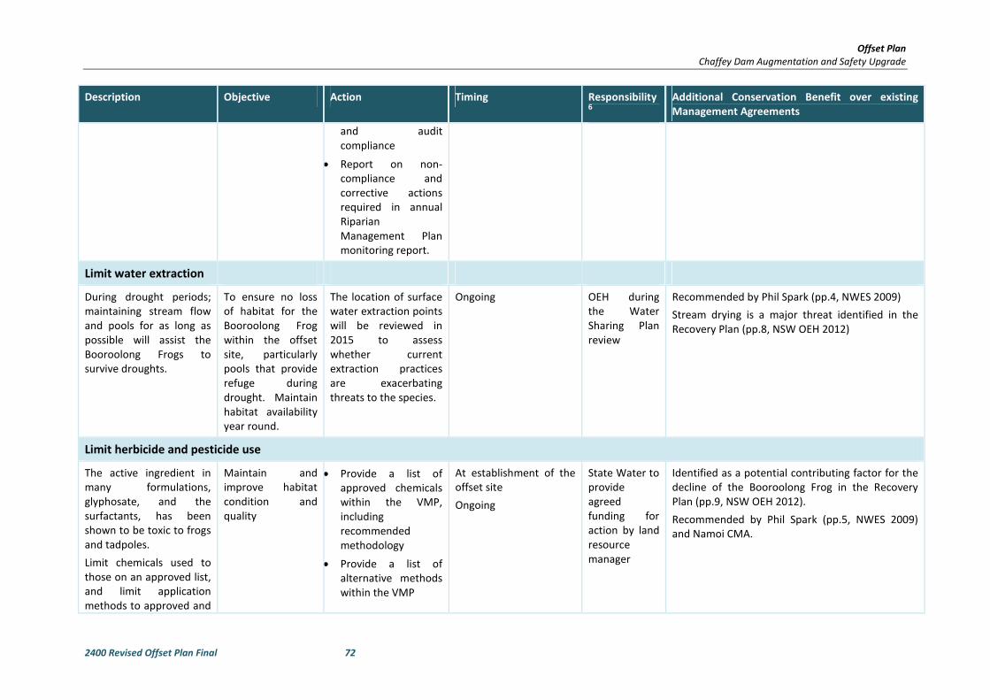
Offset Plan
Chaffey Dam Augmentation and Safety Upgrade
2400 Revised Offset Plan Final 72
Description Objective Action Timing Responsibility6
Additional Conservation Benefit over existing
Management Agreements
and audit
compliance
• Report on non-
compliance and
corrective actions
required in annual
Riparian
Management Plan
monitoring report.
Limit water extraction
During drought periods;
maintaining stream flow
and pools for as long as
possible will assist the
Booroolong Frogs to
survive droughts.
To ensure no loss
of habitat for the
Booroolong Frog
within the offset
site, particularly
pools that provide
refuge during
drought. Maintain
habitat availability
year round.
The location of surface
water extraction points
will be reviewed in
2015 to assess
whether current
extraction practices
are exacerbating
threats to the species.
Ongoing OEH during
the Water
Sharing Plan
review
Recommended by Phil Spark (pp.4, NWES 2009)
Stream drying is a major threat identified in the
Recovery Plan (pp.8, NSW OEH 2012)
Limit herbicide and pesticide use
The active ingredient in
many formulations,
glyphosate, and the
surfactants, has been
shown to be toxic to frogs
and tadpoles.
Limit chemicals used to
those on an approved list,
and limit application
methods to approved and
Maintain and
improve habitat
condition and
quality
• Provide a list of
approved chemicals
within the VMP,
including
recommended
methodology
• Provide a list of
alternative methods
within the VMP
At establishment of the
offset site
Ongoing
State Water to
provide
agreed
funding for
action by land
resource
manager
Identified as a potential contributing factor for the
decline of the Booroolong Frog in the Recovery
Plan (pp.9, NSW OEH 2012).
Recommended by Phil Spark (pp.5, NWES 2009)
and Namoi CMA.
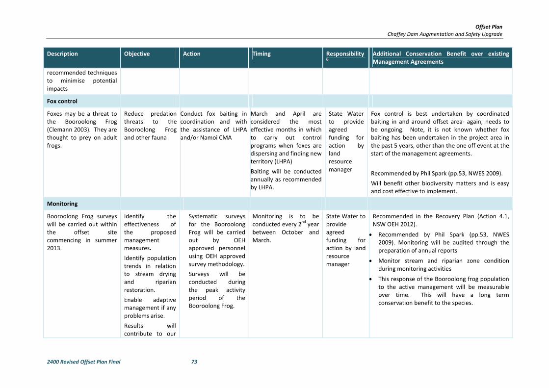
Offset Plan
Chaffey Dam Augmentation and Safety Upgrade
2400 Revised Offset Plan Final 73
Description Objective Action Timing Responsibility6
Additional Conservation Benefit over existing
Management Agreements
recommended techniques
to minimise potential
impacts
Fox control
Foxes may be a threat to
the Booroolong Frog
(Clemann 2003). They are
thought to prey on adult
frogs.
Reduce predation
threats to the
Booroolong Frog
and other fauna
Conduct fox baiting in
coordination and with
the assistance of LHPA
and/or Namoi CMA
March and April are
considered the most
effective months in which
to carry out control
programs when foxes are
dispersing and finding new
territory (LHPA)
Baiting will be conducted
annually as recommended
by LHPA.
State Water
to provide
agreed
funding for
action by
land
resource
manager
Fox control is best undertaken by coordinated
baiting in and around offset area- again, needs to
be ongoing. Note, it is not known whether fox
baiting has been undertaken in the project area in
the past 5 years, other than the one off event at the
start of the management agreements.
Recommended by Phil Spark (pp.53, NWES 2009).
Will benefit other biodiversity matters and is easy
and cost effective to implement.
Monitoring
Booroolong Frog surveys
will be carried out within
the offset site
commencing in summer
2013.
Identify the
effectiveness of
the proposed
management
measures.
Identify population
trends in relation
to stream drying
and riparian
restoration.
Enable adaptive
management if any
problems arise.
Results will
contribute to our
Systematic surveys
for the Booroolong
Frog will be carried
out by OEH
approved personnel
using OEH approved
survey methodology.
Surveys will be
conducted during
the peak activity
period of the
Booroolong Frog.
Monitoring is to be
conducted every 2nd
year
between October and
March.
State Water to
provide
agreed
funding for
action by land
resource
manager
Recommended in the Recovery Plan (Action 4.1,
NSW OEH 2012).
• Recommended by Phil Spark (pp.53, NWES
2009). Monitoring will be audited through the
preparation of annual reports
• Monitor stream and riparian zone condition
during monitoring activities
• This response of the Booroolong frog population
to the active management will be measurable
over time. This will have a long term
conservation benefit to the species.
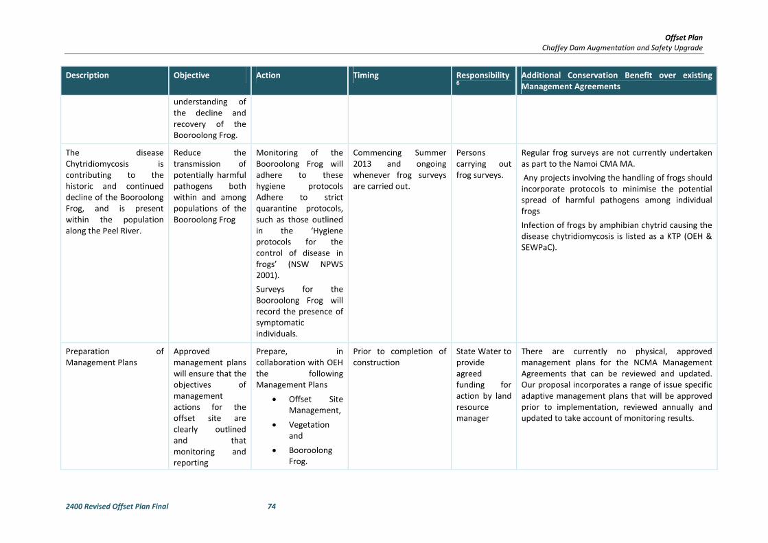
Offset Plan
Chaffey Dam Augmentation and Safety Upgrade
2400 Revised Offset Plan Final 74
Description Objective Action Timing Responsibility6
Additional Conservation Benefit over existing
Management Agreements
understanding of
the decline and
recovery of the
Booroolong Frog.
The disease
Chytridiomycosis is
contributing to the
historic and continued
decline of the Booroolong
Frog, and is present
within the population
along the Peel River.
Reduce the
transmission of
potentially harmful
pathogens both
within and among
populations of the
Booroolong Frog
Monitoring of the
Booroolong Frog will
adhere to these
hygiene protocols
Adhere to strict
quarantine protocols,
such as those outlined
in the ‘Hygiene
protocols for the
control of disease in
frogs’ (NSW NPWS
2001).
Surveys for the
Booroolong Frog will
record the presence of
symptomatic
individuals.
Commencing Summer
2013 and ongoing
whenever frog surveys
are carried out.
Persons
carrying out
frog surveys.
Regular frog surveys are not currently undertaken
as part to the Namoi CMA MA.
Any projects involving the handling of frogs should
incorporate protocols to minimise the potential
spread of harmful pathogens among individual
frogs
Infection of frogs by amphibian chytrid causing the
disease chytridiomycosis is listed as a KTP (OEH &
SEWPaC).
Preparation of
Management Plans
Approved
management plans
will ensure that the
objectives of
management
actions for the
offset site are
clearly outlined
and that
monitoring and
reporting
Prepare, in
collaboration with OEH
the following
Management Plans
• Offset Site
Management,
• Vegetation
and
• Booroolong
Frog.
Prior to completion of
construction
State Water to
provide
agreed
funding for
action by land
resource
manager
There are currently no physical, approved
management plans for the NCMA Management
Agreements that can be reviewed and updated.
Our proposal incorporates a range of issue specific
adaptive management plans that will be approved
prior to implementation, reviewed annually and
updated to take account of monitoring results.

Offset Plan
Chaffey Dam Augmentation and Safety Upgrade
2400 Revised Offset Plan Final 75
Description Objective Action Timing Responsibility6
Additional Conservation Benefit over existing
Management Agreements
timeframes and
responsibilities are
defined. Details of
the content of the
management plans
are provided in
Section 5.

Offset Plan
Chaffey Dam Augmentation and Safety Upgrade
2400 Revised Offset Plan Final 76
Table 4-3 Demonstration of Additional Conservation Benefit from proposed Offset Plan, relative to existing Management Agreements.
NCMA MANAGEMENT MEASURES
RELEVANT TO BOOROOLONG FROG
NCMA ACTUAL PROPOSED MEASURE UNDER
THIS OFFSET PLAN
ENHANCEMENT/ ADDITIONAL CONSERVATION BENEFIT
PROVIDED BY THIS OFFSET PLAN
Clearing of native vegetation must be
undertaken in accordance with the
Native Vegetation Act.
Assumed to have
complied.
Maintain legal compliance.
Penalties for breaches.
All fencing is to be maintained in a stock
proof condition for the life of this
agreement.
To protect wildlife, fencing erected as
part of this project will not have a top
strand or a bottom strand consisting of
barbed wire.
Electric fence wires will not be placed
closer than 30cm to the ground.
Fencing was part of
some contracts
between NCMA and
landholders.
Current condition of
fences and length of
offset fenced is
unknown.
Maintain and monitor.
The implementation of management measures will be
extended beyond the next 5 years to the life of the dam.
The funding agreement for the offset site cannot be
terminated as is the case with current arrangements.
Maintenance of fencing will be ongoing for the life of the
dam. Long term maintenance of fencing provides
protection of the offset site against the key threatening
process of stream degradation in the long term.
This will provide long term protection of the riparian zone
and stream environment from the adverse impacts of stock
trampling. Ultimately this will result in greater breeding
success of the frogs as important oviposition sites in rock
crevices will not be lost and impacts of sedimentation will
be reduced. Improved breeding success over the long term
will improve the resilience of the population to stochastic
events such as drought and flood.
Additional fencing of crown land will occur under the
proposed offset. Fencing will be maintained for the life of
the dam.
Comprehensive threat mapping will be conducted at
implementation of offset plan. This will establish a baseline
against which progress can be measured in the long term.
Threat mapping will include an audit of fence condition and
maintenance needs. Thereafter fence condition and
maintenance needs will be reviewed annually and reported
in monitoring reports.
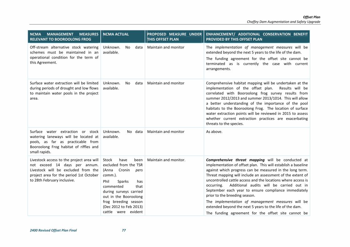
Offset Plan
Chaffey Dam Augmentation and Safety Upgrade
2400 Revised Offset Plan Final 77
NCMA MANAGEMENT MEASURES
RELEVANT TO BOOROOLONG FROG
NCMA ACTUAL PROPOSED MEASURE UNDER
THIS OFFSET PLAN
ENHANCEMENT/ ADDITIONAL CONSERVATION BENEFIT
PROVIDED BY THIS OFFSET PLAN
Off-stream alternative stock watering
schemes must be maintained in an
operational condition for the term of
this Agreement.
Unknown. No data
available.
Maintain and monitor The implementation of management measures will be
extended beyond the next 5 years to the life of the dam.
The funding agreement for the offset site cannot be
terminated as is currently the case with current
arrangements.
Surface water extraction will be limited
during periods of drought and low flows
to maintain water pools in the project
area.
Unknown. No data
available.
Maintain and monitor Comprehensive habitat mapping will be undertaken at the
implementation of the offset plan. Results will be
correlated with Booroolong frog survey results from
summer 2012/2013 and summer 2013/1014. This will allow
a better understanding of the importance of the pool
habitats to the Booroolong Frog. The location of surface
water extraction points will be reviewed in 2015 to assess
whether current extraction practices are exacerbating
threats to the species.
Surface water extraction or stock
watering laneways will be located at
pools, as far as practicable from
Booroolong Frog habitat of riffles and
small rapids.
Unknown. No data
available.
Maintain and monitor As above.
Livestock access to the project area will
not exceed 14 days per annum.
Livestock will be excluded from the
project area for the period 1st October
to 28th February inclusive.
Stock have been
excluded from the TSR
(Anna Cronin pers
comm.).
Phil Sparks has
commented that
during surveys carried
out in the Booroolong
frog breeding season
(Dec 2012 to Feb 2013)
cattle were evident
Maintain and monitor. Comprehensive threat mapping will be conducted at
implementation of offset plan. This will establish a baseline
against which progress can be measured in the long term.
Threat mapping will include an assessment of the extent of
uncontrolled cattle access and the locations where access is
occurring. Additional audits will be carried out in
September each year to ensure compliance immediately
prior to the breeding season.
The implementation of management measures will be
extended beyond the next 5 years to the life of the dam.
The funding agreement for the offset site cannot be
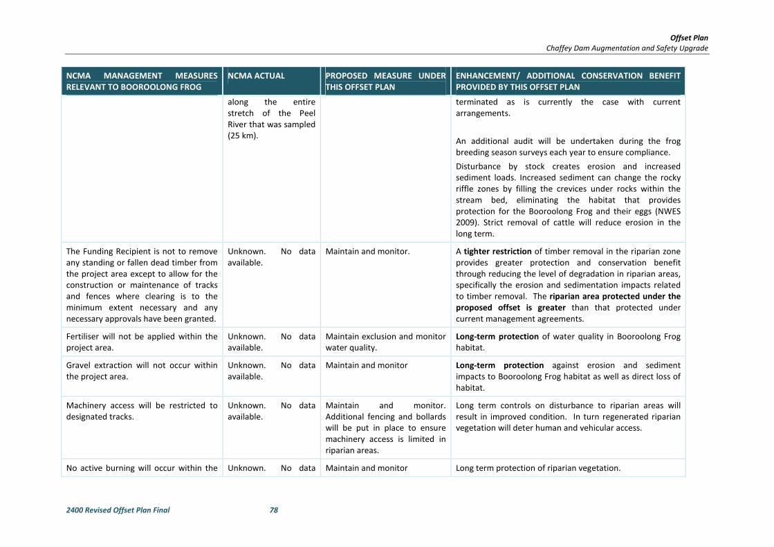
Offset Plan
Chaffey Dam Augmentation and Safety Upgrade
2400 Revised Offset Plan Final 78
NCMA MANAGEMENT MEASURES
RELEVANT TO BOOROOLONG FROG
NCMA ACTUAL PROPOSED MEASURE UNDER
THIS OFFSET PLAN
ENHANCEMENT/ ADDITIONAL CONSERVATION BENEFIT
PROVIDED BY THIS OFFSET PLAN
along the entire
stretch of the Peel
River that was sampled
(25 km).
terminated as is currently the case with current
arrangements.
An additional audit will be undertaken during the frog
breeding season surveys each year to ensure compliance.
Disturbance by stock creates erosion and increased
sediment loads. Increased sediment can change the rocky
riffle zones by filling the crevices under rocks within the
stream bed, eliminating the habitat that provides
protection for the Booroolong Frog and their eggs (NWES
2009). Strict removal of cattle will reduce erosion in the
long term.
The Funding Recipient is not to remove
any standing or fallen dead timber from
the project area except to allow for the
construction or maintenance of tracks
and fences where clearing is to the
minimum extent necessary and any
necessary approvals have been granted.
Unknown. No data
available.
Maintain and monitor. A tighter restriction of timber removal in the riparian zone
provides greater protection and conservation benefit
through reducing the level of degradation in riparian areas,
specifically the erosion and sedimentation impacts related
to timber removal. The riparian area protected under the
proposed offset is greater than that protected under
current management agreements.
Fertiliser will not be applied within the
project area.
Unknown. No data
available.
Maintain exclusion and monitor
water quality.
Long-term protection of water quality in Booroolong Frog
habitat.
Gravel extraction will not occur within
the project area.
Unknown. No data
available.
Maintain and monitor Long-term protection against erosion and sediment
impacts to Booroolong Frog habitat as well as direct loss of
habitat.
Machinery access will be restricted to
designated tracks.
Unknown. No data
available.
Maintain and monitor.
Additional fencing and bollards
will be put in place to ensure
machinery access is limited in
riparian areas.
Long term controls on disturbance to riparian areas will
result in improved condition. In turn regenerated riparian
vegetation will deter human and vehicular access.
No active burning will occur within the Unknown. No data Maintain and monitor Long term protection of riparian vegetation.
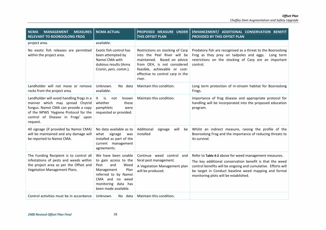
Offset Plan
Chaffey Dam Augmentation and Safety Upgrade
2400 Revised Offset Plan Final 79
NCMA MANAGEMENT MEASURES
RELEVANT TO BOOROOLONG FROG
NCMA ACTUAL PROPOSED MEASURE UNDER
THIS OFFSET PLAN
ENHANCEMENT/ ADDITIONAL CONSERVATION BENEFIT
PROVIDED BY THIS OFFSET PLAN
project area. available.
No exotic fish releases are permitted
within the project area.
Exotic fish control has
been attempted by
Namoi CMA with
dubious results (Anna
Cronin, pers. comm.).
Restrictions on stocking of Carp
into the Peel River will be
maintained. Based on advice
from OEH, is not considered
feasible, achievable or cost-
effective to control carp in the
river.
Predatory fish are recognised as a threat to the Booroolong
Frog as they prey on tadpoles and eggs. Long term
restrictions on the stocking of Carp are an important
control.
Landholder will not move or remove
rocks from the project area.
Unknown. No data
available.
Maintain this condition. Long term protection of in-stream habitat for Booroolong
Frogs.
Landholder will avoid handling frogs in a
manner which may spread Chytrid
fungus. Namoi CMA can provide a copy
of the NPWS ‘Hygiene Protocol for the
control of Disease in Frogs’ upon
request.
It is not known
whether these
pamphlets were
requested or provided.
Maintain this condition. Importance of frog disease and appropriate protocol for
handling will be incorporated into the proposed education
program.
All signage (if provided by Namoi CMA)
will be maintained and any damage will
be reported to Namoi CMA.
No data available as to
what signage was
installed as part of the
current management
agreements.
Additional signage will be
installed
Whilst an indirect measure, raising the profile of the
Booroolong Frog and the importance of reducing threats to
its survival.
The Funding Recipient is to control all
infestations of pests and weeds within
the project area as per the Offset and
Vegetation Management Plans.
We have been unable
to gain access to the
Pest and Weed
Management Plan
referred to by Namoi
CMA and no weed
monitoring data has
been made available.
Continue weed control and
feral pest management.
A Vegetation Management plan
will be produced.
Refer to Table 4-2 above for weed management measures.
The key additional conservation benefit is that the weed
control benefits will be ongoing and cumulative. Efforts will
be target in Conduct baseline weed mapping and formal
monitoring plots will be established.
Control activities must be in accordance Unknown. No data Maintain this condition.

Offset Plan
Chaffey Dam Augmentation and Safety Upgrade
2400 Revised Offset Plan Final 80
NCMA MANAGEMENT MEASURES
RELEVANT TO BOOROOLONG FROG
NCMA ACTUAL PROPOSED MEASURE UNDER
THIS OFFSET PLAN
ENHANCEMENT/ ADDITIONAL CONSERVATION BENEFIT
PROVIDED BY THIS OFFSET PLAN
with relevant legislation governing the
use of pesticides and herbicides
available.
The Funding Recipient is to restrict any
disturbance of native vegetation
required to conduct the weed
treatment to the minimum extent
necessary.
Unknown. No data
available.
Maintain this condition.
The Funding Recipient may only use
chemicals registered under the
Pesticides Act 1999 for use around
waterways for weed control in the
project area.
Unknown. No data
available.
Maintain this condition.
The Funding Recipient or subcontractor
must keep records in line with the
Pesticides Act 1999 and a copy must be
provided to the Namoi CMA upon
request.
Unknown. No data
available.
Maintain this condition.
Use of chemicals within the stream
channel (streambank toe to streambank
toe) will not occur from dates 1st
October to 28th February inclusive.
Unknown. No data
available.
Maintain this condition.
Prevention of fossicking Unknown. No data
available.
Increase community awareness
and involvement in the
Booroolong Frog recovery
program
Install bollards to
discourage sluicing at key
sites where the species
The Recovery Plan identifies fossicking as representing a
possible conflicting use in the Namoi Catchment (NSW OEH
2012).
Bollards will be erected
Threat mapping will identify locations where bollards must
be erected or fences repaired to prevent access to the
creek.
Educational material
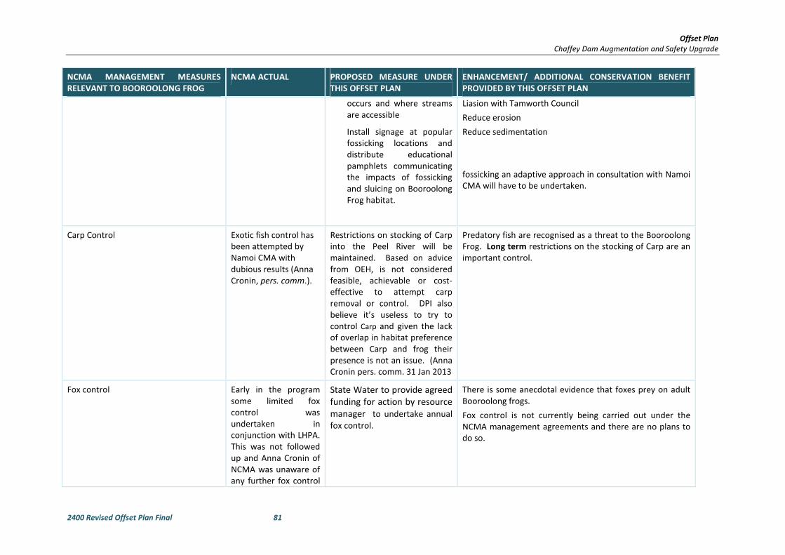
Offset Plan
Chaffey Dam Augmentation and Safety Upgrade
2400 Revised Offset Plan Final 81
NCMA MANAGEMENT MEASURES
RELEVANT TO BOOROOLONG FROG
NCMA ACTUAL PROPOSED MEASURE UNDER
THIS OFFSET PLAN
ENHANCEMENT/ ADDITIONAL CONSERVATION BENEFIT
PROVIDED BY THIS OFFSET PLAN
occurs and where streams
are accessible
Install signage at popular
fossicking locations and
distribute educational
pamphlets communicating
the impacts of fossicking
and sluicing on Booroolong
Frog habitat.
Liasion with Tamworth Council
Reduce erosion
Reduce sedimentation
fossicking an adaptive approach in consultation with Namoi
CMA will have to be undertaken.
Carp Control Exotic fish control has
been attempted by
Namoi CMA with
dubious results (Anna
Cronin, pers. comm.).
Restrictions on stocking of Carp
into the Peel River will be
maintained. Based on advice
from OEH, is not considered
feasible, achievable or cost-
effective to attempt carp
removal or control. DPI also
believe it’s useless to try to
control Carp and given the lack
of overlap in habitat preference
between Carp and frog their
presence is not an issue. (Anna
Cronin pers. comm. 31 Jan 2013
Predatory fish are recognised as a threat to the Booroolong
Frog. Long term restrictions on the stocking of Carp are an
important control.
Fox control Early in the program
some limited fox
control was
undertaken in
conjunction with LHPA.
This was not followed
up and Anna Cronin of
NCMA was unaware of
any further fox control
State Water to provide agreed
funding for action by resource
manager to undertake annual
fox control.
There is some anecdotal evidence that foxes prey on adult
Booroolong frogs.
Fox control is not currently being carried out under the
NCMA management agreements and there are no plans to
do so.

Offset Plan
Chaffey Dam Augmentation and Safety Upgrade
2400 Revised Offset Plan Final 82
NCMA MANAGEMENT MEASURES
RELEVANT TO BOOROOLONG FROG
NCMA ACTUAL PROPOSED MEASURE UNDER
THIS OFFSET PLAN
ENHANCEMENT/ ADDITIONAL CONSERVATION BENEFIT
PROVIDED BY THIS OFFSET PLAN
activities.
Adhere to strict quarantine protocols,
such as those outlined in the ‘Hygiene
protocols for the control of disease in
frogs’ (NSW NPWS 2001)
Reduce the
transmission of
potentially harmful
pathogens both within
and among
populations of the
Booroolong Frog
The disease Chytridiomycosis is contributing to the historic
and continued decline of the Booroolong Frog, and is
present within the population along the Peel River. Any
projects involving the handling of frogs should incorporate
protocols to minimise the potential spread of harmful
pathogens among individual frogs.

Offset Plan
Chaffey Dam Augmentation and Safety Upgrade
2400 Revised Offset Plan Final 83
5 COMPLIANCE MONITORING AND MANAGEMENT
OF THE OFFSET SITE
The offset sites will be managed as part of the offset site management plan (OSMP) to maintain and
enhance the ecological values of each ecological community, whilst conserving threatened flora and the
associated habitat of native fauna.
The OSMP would provide the following:
• The aims of the management and monitoring
• Clear maps showing areas under management, for each category of threat management
• Timeframes and reporting requirements
• Thresholds for adaptive action
• Site Management responsibilities.
• Corrective actions for non-compliance on audited aspects
• Background on general Booroolong Frog ecology
• Background on Booroolong Frog habitat and resources in context within the Upper Peel
River catchment
• Prescribe any restrictions on activities that are not to occur during specific breeding
season times
• Prescribe an installation, maintenance and monitoring schedule for any infrastructure
(signage, fencing etc)
• Document a Monitoring Program on the Booroolong Frog population. The monitoring
program will included detail on appropriate survey methodology timing and expertise
required and will be developed in consultation with and approved by OEH
• Document a Monitoring Program on the weed management activities, including location
of vegetation monitoring plots, data collection requirements, reporting requirements
• Provide a Reporting Program on all monitoring outcomes, including provision of annual
monitoring report submitted to the OEH
• Provide for revision and update of the monitoring program if required on the basis of
expert recommendations to reflect any results of the monitoring work
• Include an Implementation Schedule which details timing and responsibilities for all
aspects of the Management Plan
The management and monitoring measures to be implemented under the funding agreement would
include:
• Fixed vegetation plots within riparian vegetation to monitor and document success of
riparian restoration and weed removal activities.
o Monitoring will be conducted annually. Annual Monitoring Reports will be
provided to OEH.
o Targets and thresholds are to be set in consultation with and in agreement with
OEH.
• Annual population and habitat monitoring in the Booroolong Frog Offset Site of the Upper
Peel River as prescribed in the National Recovery Plan for Booroolong Frog, including
documentation of the distribution of all life stages along the occupied habitat.

Offset Plan
Chaffey Dam Augmentation and Safety Upgrade
2400 Revised Offset Plan Final 84
o Monitoring will be carried out to measure the response to weed management
and identify any outbreaks following weed removal or suppression. Weed
distribution and abundance should be remapped and control methods and timing
updated accordingly.
o Monitoring by landholders or public land managers according to the agreements
in place. This would include an assessment of fencing, bollards, signage and any
other exclusion or deterrent measures in order to determine maintenance
requirements.
o Adherence to hygiene protocols for Chytrid and collection of data on symptomatic
individuals during annual frog monitoring.
o Monitoring would be conducted at different scales depending on the variable
being measured.
• An annual monitoring report will be produced outlining:
o Fencing, maintenance needs.
o Stock access – breaches, related habitat disturbance, weed presence
o Progress in riparian restoration
o Weed control progress
o Report on any vertebrate pest control activities
o Results of Booroolong Frog surveys, including detailed maps and information on
life stages.
o Evidence of fossicking activities, erosion
6 CONCLUSION
This Offset Plan has been developed to satisfy NSW and Commonwealth Government requirements with
regard to offsetting, specifically:
• The DGRs and supplementary DGRs issued by DP&I
• OEH SSI Interim Offsets Policy
• OEH’s Principles for the use of biodiversity offsets in NSW
• EPBC Act Environmental Offsets Policy
The Offset Plan demonstrates that the Project impacts can be adequately compensated for by the
protection and management of two proposed offset sites.
In offsetting the vegetation types to be cleared, the BBAM has been utilised and with consideration to
the OEH SSI Interim Offsets Policy and Principles for Biodiversity Offsets in NSW, the proposed offset site
is considered adequate. The proposed offset site is available and can be secured for the life of the dam.
Ecosystem credits for River Oak riparian woodland and species credits for the Booroolong Frog are also
required under the BBAM, however, an additional offset site has been calculated for this community and
species.
As documented in the Terrestrial and Aquatic Flora and Fauna Assessment, no significant impact to the
EPBC listed White Box-Yellow Box-Blakely's Red Gum Grassy Woodland and Derived Native Grassland
CEEC will result from the Project. In accordance with the EPBC Act EOP, no offset is required for this
community. However, the offset proposed under the NSW Principles for the use of offsets policy for the
TSC listed White Box-Yellow Box-Blakely's Red Gum Woodland EEC incorporates a large area of the EPBC
listed CEEC. As such, information is provided here to demonstrate the conservation outcomes for the
Offset Plan
Chaffey Dam Augmentation and Safety Upgrade
2400 Revised Offset Plan Final 85
CEEC through implementation and management of the proposed offset site according to the EPBC Act
EOP.
In relation to the Booroolong Frog offset, the EPBC OAG has been utilised to propose an adequate offset
site immediately upstream of the development site. Negotiations are underway to establish a funding
agreement with CMA for implementation of the Booroolong Frog Recovery Program along a 9 km reach
of the Peel River which is known Booroolong Frog habitat. The funding agreement will be a legally
binding agreement ensuring the site is managed for the life of the dam. The funding agreement will
provide security and longevity of protection and improvement measures aimed at protecting important
habitat for the Booroolong frog. Management of the offset site will continue and build on to the existing
management measures to provide comprehensive and long term management of the offset site
Monitoring of the offset site will ensure compliance with those management measures and allow for
adaptive management. The offset package as a whole is considered to satisfy all State and Federal
requirements.
Proposed measures for management of the offset sites, to ensure that its biodiversity values are
protected and maintained for the life of the dam, have been provided and will be developed further in
detailed management plans prior to completion of construction.

2400 Revised Offset Plan Final A-I
APPENDIX A BIOBANKING ASSESSMENT
METHODOLOGY CREDIT STATEMENTS
A.1 DEVELOPMENT SITE

2400 Revised Offset Plan Final A-II
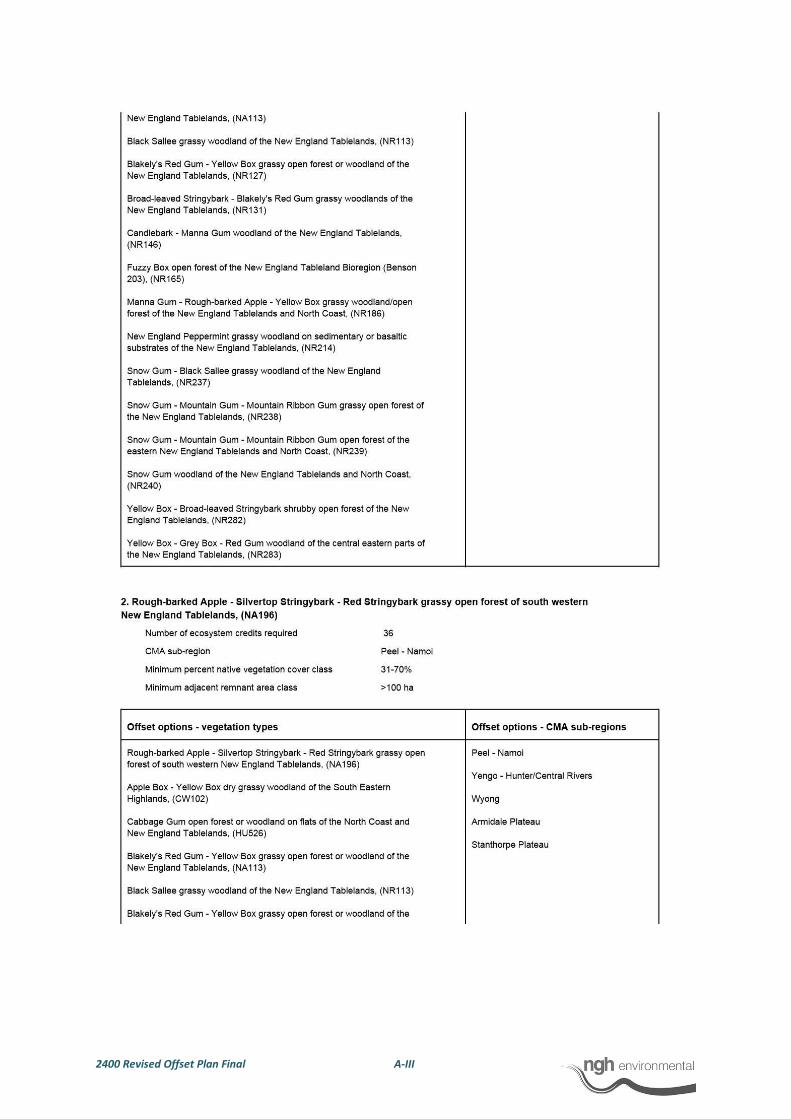
2400 Revised Offset Plan Final A-III
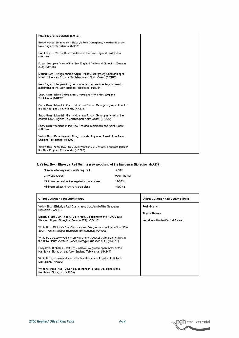
2400 Revised Offset Plan Final A-IV

2400 Revised Offset Plan Final A-V
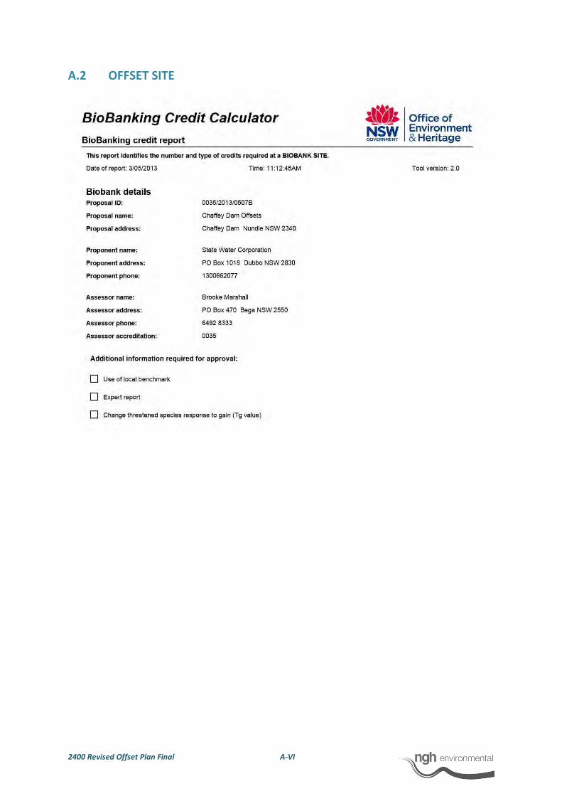
2400 Revised Offset Plan Final A-VI
A.2 OFFSET SITE
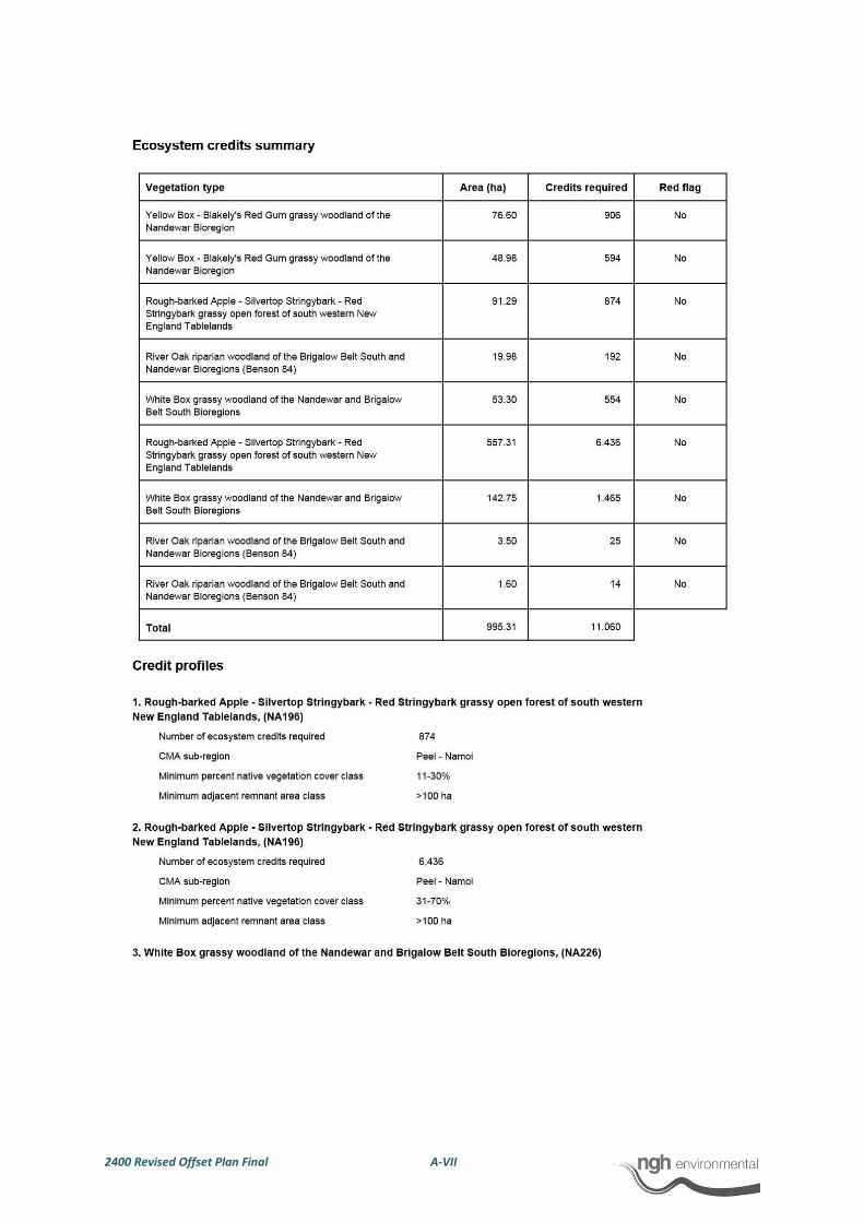
2400 Revised Offset Plan Final A-VII
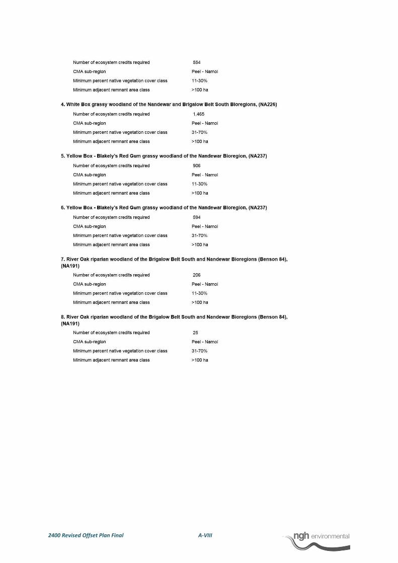
2400 Revised Offset Plan Final A-VIII
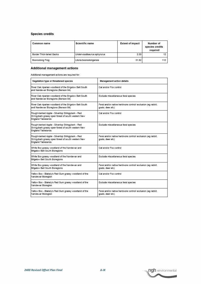
2400 Revised Offset Plan Final A-IX
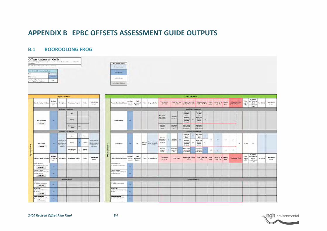
2400 Revised Offset Plan Final B-I
APPENDIX B EPBC OFFSETS ASSESSMENT GUIDE OUTPUTS
B.1 BOOROOLONG FROG

2400 Revised Offset Plan Final B-II
B.2 WHITE BOX-YELLOW BOX BLAKELY’S RED GUM GRASSY WOODLAND
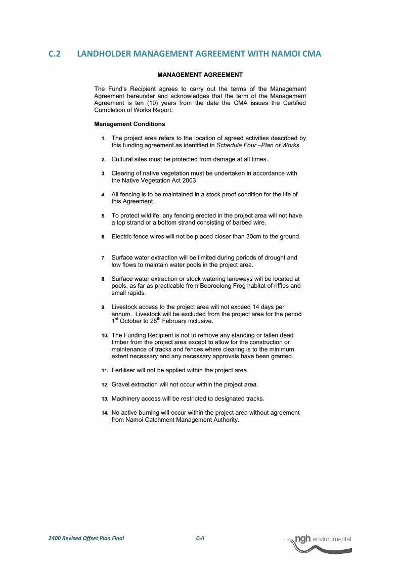
2400 Revised Offset Plan Final C-II
C.2 LANDHOLDER MANAGEMENT AGREEMENT WITH NAMOI CMA

2400 Revised Offset Plan Final C-III

2400 Revised Offset Plan Final D-I
APPENDIX D NORTH-WEST OFFSET SITE CONDITION CLASSES (COMMONWEALTH)
°
0 200 400100 Meters
1:20000
www.nghenvironmental.com.au
A4 @Name: 2400 - 10
Author: DM
Proposed offset site
Box-Gum Woodland (EPBC)
Understorey only
Both overstorey & understorey
Notes:
- Field data collected by nghenvironmental field staff
(May and October 2012 )- Base map sourced from ESRI Online © 2010
Microsoft Corporation and its da ta suppliers
- Study area digitised by nghenvironmental based on
CAD layers supplied by Worley Parsons October 2012
301015-02980-LET-0007_31052013.doc 31 May 2013
ATTACHMENT B
State Water Letter
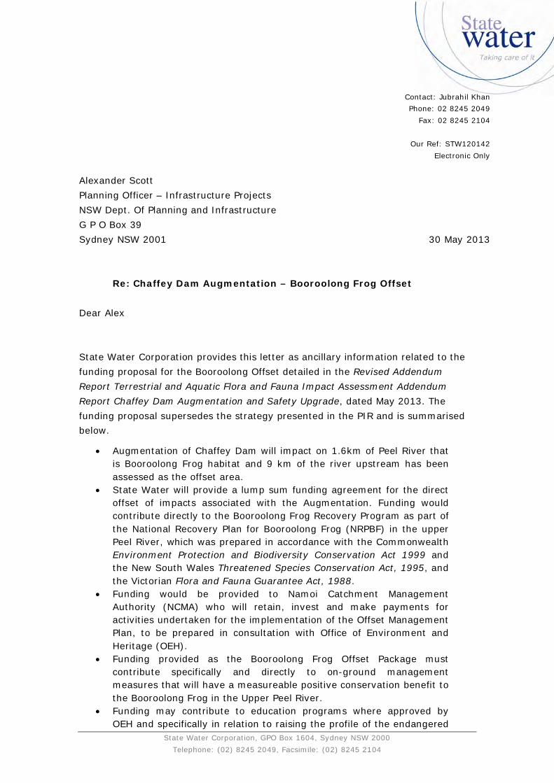
State Water Corporation, GPO Box 1604, Sydney NSW 2000 Telephone: (02) 8245 2049, Facsimile: (02) 8245 2104
Re: Chaffey Dam Augmentation – Booroolong Frog Offset Dear Alex State Water Corporation provides this letter as ancillary information related to the funding proposal for the Booroolong Offset detailed in the Revised Addendum Report Terrestrial and Aquatic Flora and Fauna Impact Assessment Addendum Report Chaffey Dam Augmentation and Safety Upgrade, dated May 2013. The funding proposal supersedes the strategy presented in the PIR and is summarised below.
Augmentation of Chaffey Dam will impact on 1.6km of Peel River that is Booroolong Frog habitat and 9 km of the river upstream has been assessed as the offset area.
State Water will provide a lump sum funding agreement for the direct offset of impacts associated with the Augmentation. Funding would contribute directly to the Booroolong Frog Recovery Program as part of the National Recovery Plan for Booroolong Frog (NRPBF) in the upper Peel River, which was prepared in accordance with the Commonwealth Environment Protection and Biodiversity Conservation Act 1999 and the New South Wales Threatened Species Conservation Act, 1995, and the Victorian Flora and Fauna Guarantee Act, 1988.
Funding would be provided to Namoi Catchment Management Authority (NCMA) who will retain, invest and make payments for activities undertaken for the implementation of the Offset Management Plan, to be prepared in consultation with Office of Environment and Heritage (OEH).
Funding provided as the Booroolong Frog Offset Package must contribute specifically and directly to on-ground management measures that will have a measureable positive conservation benefit to the Booroolong Frog in the Upper Peel River.
Funding may contribute to education programs where approved by OEH and specifically in relation to raising the profile of the endangered
Contact: Jubrahil Khan Phone: 02 8245 2049
Fax: 02 8245 2104
Our Ref: STW120142 Electronic Only
Alexander Scott Planning Officer – Infrastructure Projects NSW Dept. Of Planning and Infrastructure G P O Box 39 Sydney NSW 2001
30 May 2013
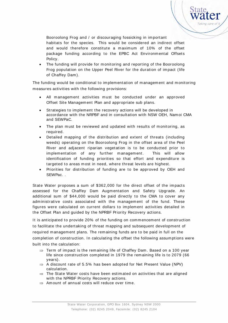
State Water Corporation, GPO Box 1604, Sydney NSW 2000 Telephone: (02) 8245 2049, Facsimile: (02) 8245 2104
Booroolong Frog and / or discouraging fossicking in important habitats for the species. This would be considered an indirect offset and would therefore constitute a maximum of 10% of the offset package funding according to the EPBC Act Environmental Offsets Policy.
The funding will provide for monitoring and reporting of the Booroolong Frog population on the Upper Peel River for the duration of impact (life of Chaffey Dam).
The funding would be conditional to implementation of management and monitoring measures activities with the following provisions:
All management activities must be conducted under an approved Offset Site Management Plan and appropriate sub plans.
Strategies to implement the recovery actions will be developed in accordance with the NRPBF and in consultation with NSW OEH, Namoi CMA and SEWPaC.
The plan must be reviewed and updated with results of monitoring, as required.
Detailed mapping of the distribution and extent of threats (including weeds) operating on the Booroolong Frog in the offset area of the Peel River and adjacent riparian vegetation is to be conducted prior to implementation of any further management. This will allow identification of funding priorities so that effort and expenditure is targeted to areas most in need, where threat levels are highest.
Priorities for distribution of funding are to be approved by OEH and SEWPac. .
State Water proposes a sum of $362,000 for the direct offset of the impacts assessed for the Chaffey Dam Augmentation and Safety Upgrade. An additional sum of $44,000 would be paid directly to the CMA to cover any administrative costs associated with the management of the fund. These figures were calculated on current dollars to implement activities detailed in the Offset Plan and guided by the NPRBF Priority Recovery actions.
It is anticipated to provide 20% of the funding on commencement of construction to facilitate the undertaking of threat mapping and subsequent development of required management plans. The remaining funds are to be paid in full on the completion of construction. In calculating the offset the following assumptions were built into the calculation:
Term of impact is the remaining life of Chaffey Dam. Based on a 100 year life since construction completed in 1979 the remaining life is to 2079 (66 years).
A discount rate of 5.5% has been adopted for Net Present Value (NPV) calculation.
The State Water costs have been estimated on activities that are aligned with the NPRBF Priority Recovery actions.
Amount of annual costs will reduce over time.
State Water Corporation, GPO Box 1604, Sydney NSW 2000 Telephone: (02) 8245 2049, Facsimile: (02) 8245 2104
Please contact Jubrahil Khan Project Manager Chaffey Dam Augmentation and Safety Upgrade on email: [email protected] for further information Yours sincerely
Jubrahil Khan Project Manager Chaffey Dam