ch ap ter 2 study guide for content …jte35633/worksheets/earthscience/studyguide2.pdfstudy guide...
TRANSCRIPT

Cop
yrig
ht
© G
len
coe/
McG
raw
-Hil
l, a
div
isio
n o
f th
e M
cGra
w-H
ill
Com
pan
ies,
In
c.
Study Guide for Content Mastery Chapter 2 Earth Science: Geology, the Environment, and the Universe 7
SECTION 2.1 Latitude and Longitude
In your textbook, read about latitude and longitude.Match the definition in Column A with the term in Column B.
Column A Column B
1 . Science of mapmaking
2. Imaginar y line t h at s epar ates E ar t h into nor t h er n and s ou t h er n h emis ph er es
3 . D is tance in d egr ees nor t h or s ou t h of t h e eq u ator
4 . D is tance in d egr ees eas t or w es t of t h e pr imemer id ian
5 . R efer ence point for longitu d e t h at pas s es t h r ou ghG r eenw ich , E ngland , and r epr es ents 0 °
I n the s p ace at the left, write true if the s tatement is true; if the s tatement is fals e,chang e the italiciz ed word or p hras e to mak e it true.
6 . T h e eq u ator is located h alfw ay b et w een t h e nor t h pole and t h e p rim e m eridian.
7 . L ines of latitude r u n par allel to t h e eq u ator.
8 . T h e eq u ator is at 1 8 0 ° latit u d e.
9 . T h e s ou t h pole is at 9 0 ° s ou t h longitude.
1 0 . O ne degree of latit u d e is eq u iv alent to ab ou t 1 1 1 km on E ar t h ’s s u r face.
1 1 . E ach d egr ee of latit u d e is d iv id ed into 3 6 0 m inutes .
1 2. L ines of longitu d e ar e als o called m eridians .
1 3 . T h e pr ime mer id ian is t h e r efer ence line for latitude.
1 4 . P oints eas t of t h e pr ime mer id ian ar e located b et w een 0 ° and 1 8 0 °eas t longitu d e.
1 5 . L ines of longitu d e ar e s em ic irc les t h at ex tend fr om th e nor t h pole to t h e s ou t h pole.
1 6 . E ach d egr ee of longitu d e cor r es pond s to ab ou t 1 1 1 km at t h e north p ole.
1 7 . A ll mer id ians conv er ge at t h e p oles .
a . pr ime mer id ian
b . longitu d e
c . car togr aph y
d . eq u ator
e . latit u d e
Mapping Our World
Name Class Date
STUDY GUIDE FOR CONTENT MASTERYCH AP TER 2

Cop
yrig
ht
© G
len
coe/
McG
raw
-Hil
l, a
div
isio
n o
f th
e M
cGra
w-H
ill
Com
pan
ies,
In
c.
Name Class Date
SECTION 2.1 Latitude and Longitude, c ontinued
In your textbook, read about locating places with coordinates.Use the map grid to answer the following questions.
18. What is the latitude of point A?
19. Which two points have the same latitude? What is that latitude?
20. What is the longitude of point B ?
21. Which two points have the same longitude? What is that longitude?
22. What are the coordinates of point C ?
In your textbook, read about time z ones.Circle the letter of the choice that b est completes the statement or answers the question.
23. Into how many time z ones is Earth divided?
a. 12 b. 2 4 c. 6 0 d. 3 6 0
24. Approximately how wide is each time z one?
a. 15 ° b. 3 0° c. 6 0° d. 18 0°
25. The International Date Line is located at the
a. 0° line of latitude c. 0° meridian
b. 18 0° line of latitude d. 18 0° meridian
26. When you travel east across the International Date Line, you
a. advance your calendar one day c. move your calendar back one day
b. advance your calendar 12 hours d. move your calendar back 12 hours
8 Chapter 2 Earth Science: Geology, the Environment, and the Universe Study Guide for Content Mastery
STUDY GUIDE FOR CONTENT MASTERYCHAPTER 2
A
C D
B
4 6 °0 1 'N
4 6 °0 0 'N
4 5 °5 9 'N
1 0 8 °4 6 'W 1 0 8 °4 5 'W 1 0 8 °4 4 'W 1 0 8 °4 3 'W

Cop
yrig
ht
© G
len
coe/
McG
raw
-Hil
l, a
div
isio
n o
f th
e M
cGra
w-H
ill
Com
pan
ies,
In
c.
Name Class Date
SECTION 2.2 Types of Maps
In your textbook, read about Mercator, conic, and gnomonic projections.Label each map projection as conic, g nom onic or M erca tor.
W rite the name of the map projection— M erca tor, conic, or g nom onic— for eachdescription.
4. Used as road and weather maps
5. H as parallel lines of latitude and longitude
6. M ade by projecting points and lines from a globe onto a piece of paperthat touches the globe at a single point
7. Distorts direction and distance between landmasses
8. Exaggerates the areas of landmasses near the poles, but correctly showstheir shape
9. M ade by projecting points and lines from a globe onto a cone
10. H as very little distortion in the areas or shapes of landmasses that fallalong a certain line of latitude
11. Used by navigators to plot great- circle routes
Study Guide for Content Mastery Chapter 2 Earth Science: Geology, the Environment, and the Universe 9
STUDY GUIDE FOR CONTENT MASTERYCHAPTER 2
1. gnomonic
2.
3. M e rca tor

Cop
yrig
ht
© G
len
coe/
McG
raw
-Hil
l, a
div
isio
n o
f th
e M
cGra
w-H
ill
Com
pan
ies,
In
c.
Name Class Date
SECTION 2.2 Types of Maps, continued
In your textbook, read about topographic maps and contour lines.Use each of the terms below just once to complete the passage.
contour interv al contour lines hachures index contours topographic maps
Maps that show changes in elevation of Earth’s surface are called (12) . O n this
kind of map, points of equal elevation are connected by (13) . The difference in
elevation between two side-by-side contour lines is called the (14) . Contour
lines whose elevation is marked by a number on the map are known as (15) .
Contour lines that indicate depressions have (16) , or short lines at right angles
to the contour lines.
T he contour interv al on the map below is 2 0 m.Use the contour map to answer the following questions.
17. Which of the labeled points on the map has the highest elevation?
18. What is the elevation of the highest labeled point?
19. Which of the labeled points on the map has the lowest elevation?
20. What is the elevation of the lowest labeled point?
10 Chapter 2 Earth Science: Geology, the Environment, and the Universe Study Guide for Content Mastery
STUDY GUIDE FOR CONTENT MASTERYCHAPTER 2
A
B
C D
E
400
500
500
Cop
yrig
ht
© G
len
coe/
McG
raw
-Hil
l, a
div
isio
n o
f th
e M
cGra
w-H
ill
Com
pan
ies,
In
c.
Name Class Date
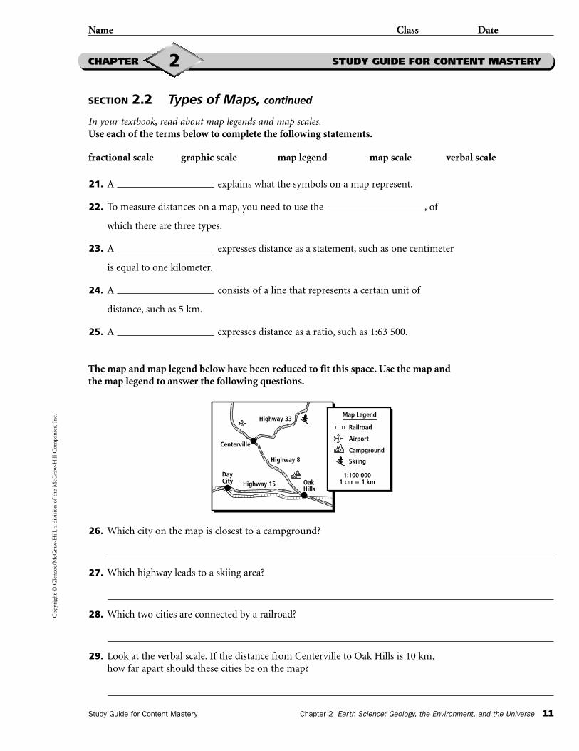
SECTION 2.2 Types of Maps, continued
In your textbook, read about map legends and map scales.Use each of the terms below to complete the following statements.
fractional scale graphic scale map legend map scale verbal scale
21. A explains what the symbols on a map represent.
22. To measure distances on a map, you need to use the , of
which there are three types.
23. A expresses distance as a statement, such as one centimeter
is equal to one kilometer.
24. A consists of a line that represents a certain unit of
distance, such as 5 km.
25. A expresses distance as a ratio, such as 1:63 500.
The map and map legend below have been reduced to fit this space. Use the map andthe map legend to answer the following questions.
26. Which city on the map is closest to a campground?
27. Which highway leads to a skiing area?
28. Which two cities are connected by a railroad?
29. Look at the verbal scale. If the distance from Centerville to Oak Hills is 10 km,how far apart should these cities be on the map?
Study Guide for Content Mastery Chapter 2 Earth Science: Geology, the Environment, and the Universe 11
STUDY GUIDE FOR CONTENT MASTERYCHAPTER 2
l l l l l l
ll
l l l l l l l l l l l l l l l l l ll l l l l l l l l l l l l l l l l
Centerville
H ig h w a y 33
H ig h w a y 8
H ig h w a y 15
Da yCity O a k
H ills
M a p L eg end
R a ilro a d
S k iing
Ca m p g ro u nd
Airp o rt
1:100 0001 c m � 1 k m

Cop
yrig
ht
© G
len
coe/
McG
raw
-Hil
l, a
div
isio
n o
f th
e M
cGra
w-H
ill
Com
pan
ies,
In
c.
Name Class Date
SECTION 2.3 Remote Sensing
In your textbook, read about the electromagnetic spectrum.Circle the letter of the choice that best completes the statement or answers the question.
1. The arrangement of electromagnetic radiation is called
a. remote sensing c. the radiation pattern
b. wave imaging d. the electromagnetic spectrum
2. Which term describes the number of waves that pass a particular point eachsecond?
a. speed b. frequency c. wavelength d. wave height
3. Which of the following is N OT a type of electromagnetic radiation?
a. X rays b. ultraviolet waves c. ocean waves d. microwaves
4. The speed of light in a vacuum is
a. 300 000 km/s b. 300 km/s c. 300 m/s d. 3 m/s
5. Which form of electromagnetic radiation has the highest frequency?
a. visible light b. radio waves c. gamma rays d. infrared waves
6. Which form of electromagnetic radiation has the lowest frequency?
a. visible light b. radio waves c. gamma rays d. infrared waves
In your textbook, read about L andsat satellites, the Topex/Poseidon satellite, and the G lobal P ositioning S ystem.Write the name of the remote sensing device—Landsat, Topex/Poseidon, or G P S —for each description.
7. Uses a system of 24 satellites that transmit microwaves
8. Uses radar to map features, such as mountains and valleys,that are on the ocean floor
9. Uses a handheld receiver to help people determine their exactposition on Earth
10. Creates images that show surface features as different colors
11. Used for ship and airplane navigation
12. Picks up bulges and depressions in ocean water
12 Chapter 2 Earth Science: Geology, the Environment, and the Universe Study Guide for Content Mastery
STUDY GUIDE FOR CONTENT MASTERYCHAPTER 2