cflr project (name/number): burney-hat creek basins ... · sno-riders, inc. northern california saf...
TRANSCRIPT

CFLR Project (Name/Number): Burney-Hat Creek Basins Project / CFLR014
National Forest: Lassen National Forest
1. Match and leveraged funds:
a. FY16 Matching Funds Documentation
Fund Source – (CFLN/CFLR Funds Expended) Total Funds Expended in Fiscal
Year 2016($)
CFLN1416 $751,291 This amount should match the amount of CFLR/CFLN dollars obligated in the PAS expenditure report. Include prior year CFLN dollars
expended in this Fiscal Year.
Fund Source – (Funds expended from
Washington Office funds (in addition to
CFLR/CFLN) (please include a new row for each
BLI))
Total Funds Expended in Fiscal
Year 2016($)
CFLM1413 $747,760 This value (aka carryover funds or WO unobligated funds) should reflect the amount expended of the allocated funds as indicated in the FY15
program direction, but does not necessarily need to be in the same BLIs or budget fiscal year as indicated in the program direction.
Fund Source – (FS Matching Funds)
Total Funds Expended in Fiscal
Year 2016($) 316,193
CFTM
CFHF
CFPR
CWKV - Unofficial match
SRS2 - Unofficial match
RTRT - Unofficial match
CWF2 - Unofficial match
CMLG - Unofficial match
$87,977
$102,208
$124,970
$187,115
$62,861
$140,353
$140,000
$15,000 The “unofficial match” line items above would have been matching dollars had we used CFLR match codes. This amount should match the amount of matching funds obligated in the gPAS expenditure report, minus the Washington Office funds listed in the box above and any partner
funds contributed through agreements (such as NFEX, SPEX, WFEX, CMEX, and CWFS) listed in the box below.
Fund Source – (Funds contributed through
agreements)
Total Funds Expended in Fiscal
Year 2016($) $88,781
University of Nevada Reno
Pit River Tribe – Water Monitoring
Sierra Institute for Community and Environment
Pit River Tribe – Cross Roads Hand Thin and Pile
Sno-Riders, Inc.
Northern California SAF – Forestry Institute for
Teachers
Forestry Educators Inc. – Shasta Forestry Challenge
$12,608
$756
$19,923
$28,000
$7,494
$12,000
$8,000
Fund Source – (Partner In-Kind Contributions) Total Funds Expended in Fiscal
Year 2016($)$37,000
United States Geological Survey $37,000

Service work accomplishment through goods-for
services funding within a stewardship contract (for
contracts awarded in FY16)
Totals $0
Total revised non-monetary credit limit for
contracts awarded in FY161 $0
b. Please provide a narrative or table describing leveraged funds in your landscape in
FY2016.
The goal of the Burney-Hat Creek Community Forest and Watershed Group is to improve social,
environmental, and economic conditions in the Burney and Hat Creek watersheds. These two
watersheds include all of the land that drains into Burney Creek and Hat Creek, totaling 364,250
acres. Fifty-eight percent of this land is in the Lassen National Forest. Another 29 percent is
owned by large private forestland owners, and 4 percent by large ranches. The communities of
Burney, Johnson Park, Hat Creek, Cassel, and Old Station lie within these two watersheds. Local
communities suffer from high unemployment and face high risks of wildfire from surrounding
forests. There is a recognized need for a coordinated public-private effort to address these and
other concerns. The goal of the project is to develop a plan to integrate sustainable natural
resource management with socioeconomic development across the two-watershed project area.
As of 2014, the total population of Shasta County was 178,520. Of this total, 18% are living in
poverty – an increase of 2.6% since 2009; 9.7 % receive public assistance – an increase of 3.1%
since 2009; and 34.7% of the population, from 16 to 64 years old, did not work – an increase of
5.9% since 2009. The Burney-Hat Creek Basins Collaborative Forest Landscape Restoration
(CFLR) project invests in our local communities by advancing sustainable landscape
management through ecological restoration work.
Ecological restoration work is important to sustain the health, diversity, and productivity of the
forest and grasslands across the project area on public, private, and tribal lands. At the watershed
scale, this work will help retain and restore ecologically resilient landscapes with:
sustainable populations of wildlife and fish,
functioning and restored watersheds and water quality,
protected cultural resources,
appropriate recreation opportunities,
jobs for diverse community members, and
economic benefits in our local communities.
This planning effort not only aims to meet the group’s goals, but also the objectives of the 10-
Year Comprehensive Strategy Implementation Plan.
1 This should be the amount in contract’s “Progress Report for Stewardship Credits, Integrated
Resources Contracts or Agreements” in cell J46, the “Revised Non-Monetary Credit Limit,” as
of September 30. Additional information on the Progress Reports is available in CFLR Annual
Report Instructions document.

The following projects are not covered elsewhere in the report. Projects completed this year that support overall project goals with leveraged funds include the following:
Lassen National Forest, where 80 acres were thinned and piled using a contract fire crew
staged on the District. In addition, several insect studies were initiated on the Forest within the
project area in cooperation with Forest Health Protection (FHP) Northeastern California Shared
Service Area ($28,500), including:
Red turpentine beetle semiochemical trapping assay, in association with the University of
Wisconsin, Regions 4 and 5 FHP, University of Nevada, Arizona and others;
Woodboring beetle colonization of conifers killed by fire and bark beetles: implications
for forest restoration and Black-backed Woodpecker conservation in association with
Institute for Bird Populations and Region 5 FHP;
Evaluation of Stem-injected Emamectin Benzoate and Propiconazole for Protecting
Ponderosa Pines from Western Pine Beetle in California in association with the Southern
Research Station and Region 5 FHP.
Lassen Volcanic National Park, where Northwest Gateway project completed project layout
and tree marking on 800 acres. ($50,000).
McArthur Burney Falls State Park completed hazard tree removal, fuels reduction, and forest health projects ($35,000).
The Pacific Crest Trail Association completed maintenance of 52.7 miles of the Pacific Crest Trail through the Hat Creek District and the project area ($16,777).
The California Department of Forestry and Fire (CAL FIRE) completed 30 acres of the
Phase II fuel break ($17,300). This fuel break is located south of the communities of Burney and
Johnson Park and is being constructed in response to the Eiler Fire.
Fruit Growers Supply Company (FGS) continued reforesting the Eiler Fire footprint area by
planting 2,128,000 seedlings on approximately 5,800 acres ($2,282,114, excluding employee
supervision costs). FGS also performed road maintenance throughout the Eiler Fire area,
including spot rocking and armoring rolling dips ($25,000). They also thinned ponderosa pine
stands on their Black project, in the Four Corners area, on lands adjacent to the Crossroads
project, on Forest Service land, within the project boundary.
Pacific Gas and Electric continues to remove drought-stricken trees and fuel from their
infrastructure, where tree mortality continues from the drought (No Cost Estimate).
California Trout has continued work on the Hat Creek restoration project on Pacific Gas and
Electric watershed lands. This project employs a multi-benefit approach of restoration,
recreation, and cultural resources (No cost estimate). The overall goals of the project are:
Restore Hat Creek wild trout populations to over 5,000 fish per mile,
Restore 1.5 miles of instream habitat with large wood debris structures, and
Protect cultural resources on over 5,000 acres of ancestral lands of the Illmawi Band of
the Pit River Tribe.
Recent accomplishments include:
Secured the largest restoration grant in organizational history from the Pacific Forest and
Watershed Lands Stewardship Council, for habitat restoration, cultural resource
protection, and recreational enhancement;
Secured all final permits and approvals, including the California Environmental Quality
Act (CEQA), section 106 of the Historic Preservation Act, Section 401 and 404 of the
Clean Water Act, Section 1600 of the CA Department of Fish and Wildlife Code
(Streambed Alteration Agreement);
Secured final project approval from PG&E (land owner), the California
Natural Resources Department, and the California Public Utility Commission (CPUC);
Restored 2,500 native plants, trees, shrubs, and grasses throughout the Wild Trout Area;
Restored 1.5 miles of recreational river trail;
Restored 1.5 miles of in-stream habitat and geomorphic function with four large wood
debris structures in the Carbon Reach; and
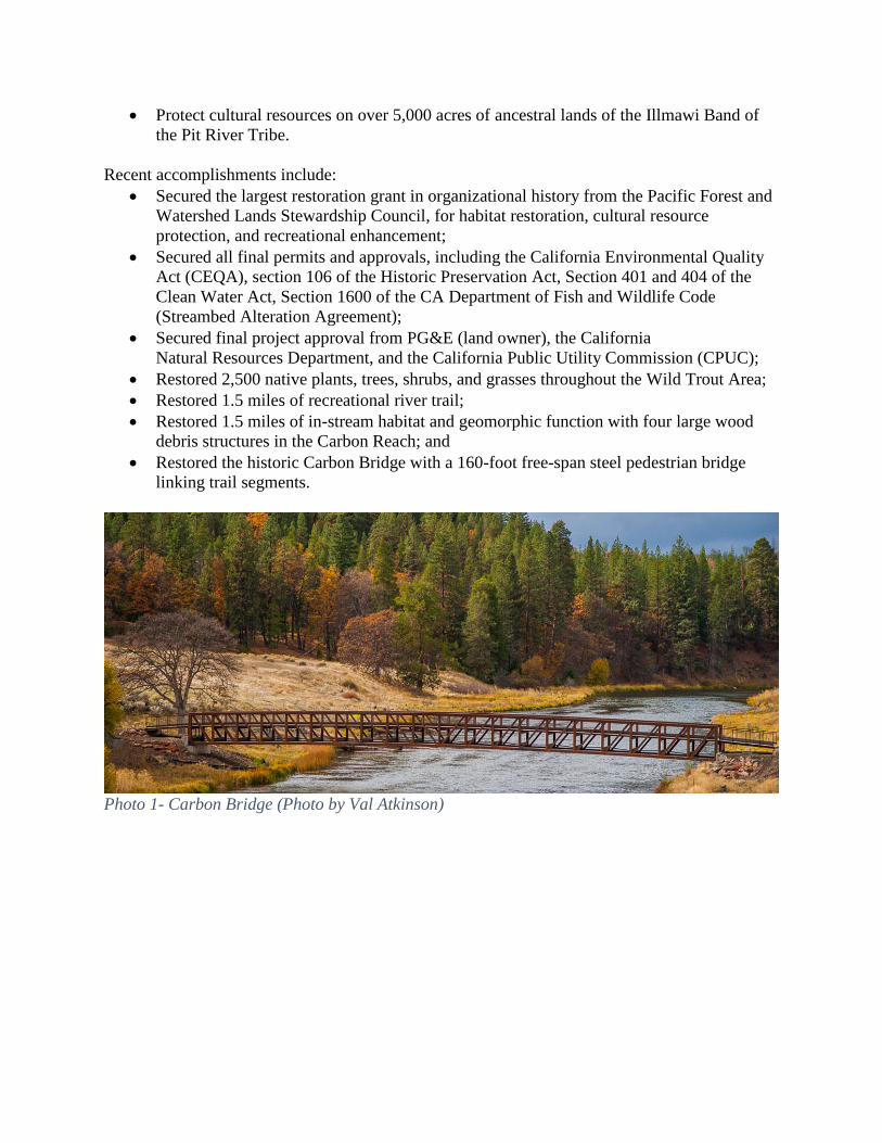
Restored the historic Carbon Bridge with a 160-foot free-span steel pedestrian bridge
linking trail segments.
Photo 1- Carbon Bridge (Photo by Val Atkinson)
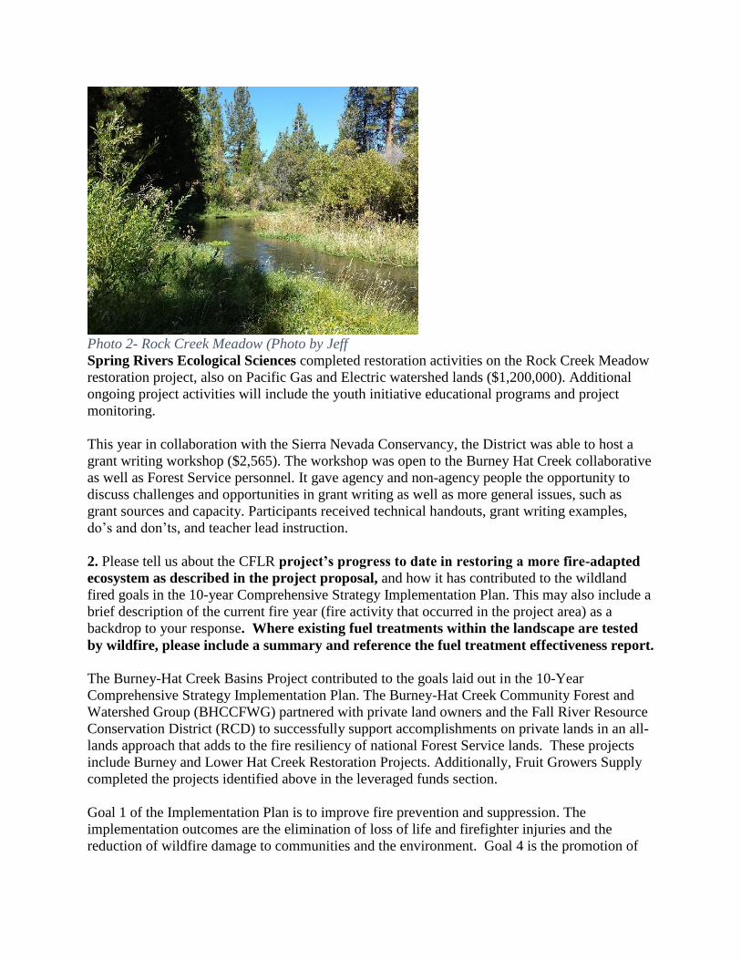
Spring Rivers Ecological Sciences completed restoration activities on the Rock Creek Meadow
restoration project, also on Pacific Gas and Electric watershed lands ($1,200,000). Additional
ongoing project activities will include the youth initiative educational programs and project
monitoring.
This year in collaboration with the Sierra Nevada Conservancy, the District was able to host a
grant writing workshop ($2,565). The workshop was open to the Burney Hat Creek collaborative
as well as Forest Service personnel. It gave agency and non-agency people the opportunity to
discuss challenges and opportunities in grant writing as well as more general issues, such as
grant sources and capacity. Participants received technical handouts, grant writing examples,
do’s and don’ts, and teacher lead instruction.
2. Please tell us about the CFLR project’s progress to date in restoring a more fire-adapted
ecosystem as described in the project proposal, and how it has contributed to the wildland
fired goals in the 10-year Comprehensive Strategy Implementation Plan. This may also include a
brief description of the current fire year (fire activity that occurred in the project area) as a
backdrop to your response. Where existing fuel treatments within the landscape are tested
by wildfire, please include a summary and reference the fuel treatment effectiveness report.
The Burney-Hat Creek Basins Project contributed to the goals laid out in the 10-Year
Comprehensive Strategy Implementation Plan. The Burney-Hat Creek Community Forest and
Watershed Group (BHCCFWG) partnered with private land owners and the Fall River Resource
Conservation District (RCD) to successfully support accomplishments on private lands in an all-
lands approach that adds to the fire resiliency of national Forest Service lands. These projects
include Burney and Lower Hat Creek Restoration Projects. Additionally, Fruit Growers Supply
completed the projects identified above in the leveraged funds section.
Goal 1 of the Implementation Plan is to improve fire prevention and suppression. The
implementation outcomes are the elimination of loss of life and firefighter injuries and the
reduction of wildfire damage to communities and the environment. Goal 4 is the promotion of
Photo 2- Rock Creek Meadow (Photo by Jeff
Cook)
community assistance, and the implementation outcome is the increased capacity to prevent
losses from wildland fire and realize economic benefits resulting from treatments and services.
The Hat Creek Ranger District continues to be staffed with 6 engines (Type III), one 10-person hand crew, two wet patrols that perform prevention work, and two lookouts within the CFLR project area: Burney Mountain and West Prospect, both lookouts are within the CFLR project area. All fire suppression resources respond inside the Project area. There are several prevention efforts that take place within the CFLR boundary: Smokey Bear appearances at the Burney Basin Day parade, at the Hat Creek Volunteer fire department BBQ, and to local preschools; and site visits by the elementary school to Forest Service District Office in Fall River Mills where students learn about fire prevention.
The project area this year experienced an unusually low number of fire starts due to the lack of
lightning. The table below lists the fires suppressed in the project area.
Fire Name Date Size (Approximate Acres)
Swale 5/5/16 .10
Hat 7/3/16 .10
Burney 7/24/16 .10
Eskimo 8/18/16 .10
Two local fire safe councils continue to partner with the Burney-Hat Creek Community Forest and Watershed Collaborative to plan and accomplish project work in at-risk Wildland Urban Interface (WUI) areas. Treatments to reduce fire risk around the communities of Old Station, Burney and Johnson Park have continued. These projects currently involve hand thinning, piling, and burning of piles to reduce fuels. The burn plan for the Old Station area, approved in fall of 2016, includes underburning treated areas. Depending upon weather conditions, underburning will occur in the spring and fall of 2017. Two hundred nineteen acres within the Shooter timber sale project area were put into contract for machine piling to complete the DFPZ in that area, and one hundred sixty-three acres were completed this fall. Burning these piles will occur as weather conditions allow. Hand piles constructed under the following projects, were burned during the fall of 2015, and will continue to be burned during the fall of 2016: Ashpan, Reading Fire salvage, Eiler Fire Area, Summit Lake, Old Station, Four Corners, and Burney Springs Mountain area.
Currently, the District is working on the following projects for fuels management in the CFLR
area:
Underburning in the CFLR area under the Eastside Underburn Project,
Old Station WUI underburn, and Continued burning of hand and machine piles as stated.
All burning is weather dependent.
Goal 2 of the Implementation Plan is to reduce hazardous fuels, and the implementation outcome is the reduction of wildfire risk to communities and the environment.

A total of 2,557 acres of hazardous fuels were treated on national Forest Service lands within the project area during FY16. Of these acres, 293 acres were within WUI and 2,264 acres were non-WUI. Broadcast burning in the CFLR area this year was more successful due to the break-down of the high pressure ridge. The following table displays the treatment types and acres treated.
Treatment Type Acres
Broadcast Burning 1,073 acres
Machine Pile 1,015 acres
Burning of Pile 495 acres
Hand thin and hand pile 312 acres
Mastication 333acres
Additional work completed inside the CFLR boundary by the fire crews includes:
opened and maintained trails within the Thousand Lakes Wilderness,
felled hazard trees in the campgrounds, and
Processed the wood for firewood, hand thinned and piled within the Old Station WUI and
South Station project boundaries.
3. What assumptions were used in generating the numbers and/or percentages you
plugged into the TREAT tool? The values represented in the TREAT model were generated from work plan, Timber Sale Statement of Account (TSSA), Corporate Data Warehouse (CDW) reports, and contract data.
FY 2016 Jobs Created/Maintained (FY16 CFLR/CFLN/ WO carryover funding):
Jobs (Full
and Part-
Time)
(Total)
Jobs (Full
and Part-
Time)
(Direct)
Labor
Income
(Total)
Income (Direct)
Timber harvesting component 73 99 3,792,072 5,505,129
Forest and watershed
restoration component 3 3 37,192 51,535
Mill processing component 467 1,154 18,826,583 37,075,742
Implementation and
monitoring 8 11 520,668 639,486
Jobs (Full
and Part-
Time)
(Total)
Jobs (Full
and Part-
Time)
(Direct)
Labor
Income
(Total)
Income (Direct)
Other Project Activities 1 2 72,144 107,122
TOTALS: 553 1,270 23,248,659 43,379,014
Values obtained from Treatment for Restoration Economic Analysis Tool (TREAT) spreadsheet, “Impacts-Jobs and Income” tab. Spreadsheet
and directions available at http://www.fs.fed.us/restoration/CFLR/submittingproposals.shtml#tools.
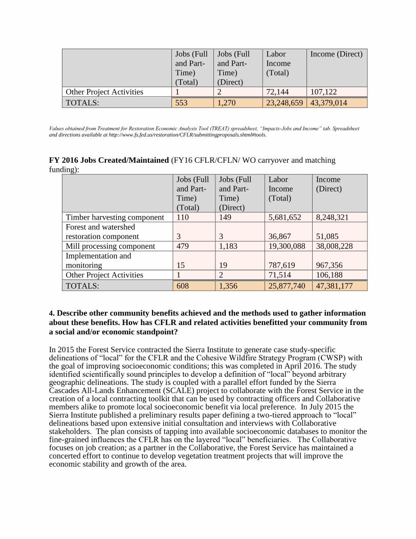
FY 2016 Jobs Created/Maintained (FY16 CFLR/CFLN/ WO carryover and matching
funding):
Jobs (Full
and Part-
Time)
(Total)
Jobs (Full
and Part-
Time)
(Direct)
Labor
Income
(Total)
Income
(Direct)
Timber harvesting component 110 149 5,681,652 8,248,321
Forest and watershed
restoration component 3 3 36,867 51,085
Mill processing component 479 1,183 19,300,088 38,008,228
Implementation and
monitoring 15 19 787,619 967,356
Other Project Activities 1 2 71,514 106,188
TOTALS: 608 1,356 25,877,740 47,381,177
4. Describe other community benefits achieved and the methods used to gather information
about these benefits. How has CFLR and related activities benefitted your community from
a social and/or economic standpoint?
In 2015 the Forest Service contracted the Sierra Institute to generate case study-specific delineations of “local” for the CFLR and the Cohesive Wildfire Strategy Program (CWSP) with the goal of improving socioeconomic conditions; this was completed in April 2016. The study identified scientifically sound principles to develop a definition of “local” beyond arbitrary geographic delineations. The study is coupled with a parallel effort funded by the Sierra Cascades All-Lands Enhancement (SCALE) project to collaborate with the Forest Service in the creation of a local contracting toolkit that can be used by contracting officers and Collaborative members alike to promote local socioeconomic benefit via local preference. In July 2015 the Sierra Institute published a preliminary results paper defining a two-tiered approach to “local” delineations based upon extensive initial consultation and interviews with Collaborative stakeholders. The plan consists of tapping into available socioeconomic databases to monitor the fine-grained influences the CFLR has on the layered “local” beneficiaries. The Collaborative focuses on job creation; as a partner in the Collaborative, the Forest Service has maintained a concerted effort to continue to develop vegetation treatment projects that will improve the economic stability and growth of the area.

Throughout the year various projects on the District have provided both social and economic
community benefits. Though many of these benefits are currently measured only qualitatively,
we acknowledge the need to develop a tracking method to mitigate the challenges of monitoring
the benefits and short comings of CFLR projects. As described in the case study Monitoring
Socioeconomics within Collaborative Forestry Projects; trends in Practices and Challenges
completed by Sierra Institute in February of 2016, we still need to define what we are
considering “local”. We need to assess our project area by size and locality, establish indicators,
and ensure that trained professionals are available to properly process the data.
There is still a need to define economic and social indicators as well as an effective protocol for
monitoring both the benefits and shortcomings of CFLR projects at the district level. However,
we are still able to see the success of our efforts. This year overnight recreation usage in the Hat
Creek Recreation Corridor increased 19% from last year. This increase has a direct impact on the
community and business of Old Station (closest to the Hat Creek Recreation corridor), Burney,
Cassel, and the Intermountain communities of Fall River Mills and McArthur. These areas
provide abundant recreation opportunities for travelers as well as local community members.
Another benefit to the community was the creation of the Youth Conservation Crew. Over an
eight-week period, local high school students were taught natural resource management skills
both in the field and in the classroom. The crew received over 40 hours of environmental
education training as well as resume-building skills. An interdisciplinary instruction approach
was taken, as a member from each resource spent several days with students in the field. Projects
included re-rocking and maintaining sections of the Pacific Crest Trail, armoring a watering site
at an adjacent equestrian campsite, conducting stream surveys along Hat Creek, marking
hazardous trees along Highway 44 for removal by the California Department of Transportation,
thinning trees for traffic safety, mapping and preparing a thinning project to restore viewing
opportunities of Mount Lassen at our vista point, performing wildlife surveys, and building
fences to protect wetlands and aspen area. The culminating experience for the crew was their
overnight backpacking trip into the Thousand Lakes Wilderness. Here they further developed
their team skills as they rehabilitated campsites and maintained trails. Again, the lasting social
and economic benefits are hard to monitor. However, members of the crew announced plans to
attend college, join the California Conservation Corps, and work as a wildland firefighter after
graduating from high school.
Another important economic aspect of the collaborative was the passage of Senate Bill 859 (SB
859), which requires local publicly-owned electric utilities to procure 125 megawatts of energy
from forest feedstock (biofuel). This bill gives the forest an opportunity to restore landscapes and
fire resiliency by decreasing fuels and stand densities through the removal of small diameter,
non-merchantable timber. Members of the collaborative wrote letters to support this bill. Prior to
the signing of the bill, area mill employees had been given a 60-day notice of termination. This
bill saved jobs for many local families and provided some level of certainty that we will be able
to continue working toward our forest management goals while still creating jobs in our rural
communities.

5. Based on your project monitoring plan, describe the multiparty monitoring process.
What parties (who) are involved in monitoring, and how? What is being monitored? Please
briefly share key broad monitoring results and how results received to date are informing
subsequent management activities ( e.g. adaptive management), if at all. What are the
current weaknesses or shortcoming of the monitoring process?
In 2016, the Burney-Hat Creek Basin multiparty monitoring working group focused on three
aspects of the monitoring process:
(1) Improved communication between District staff and collaborative members;
(2) Refinement of the multiparty monitoring plan (MMP); and (3) Assessment of post-fire and restoration treatment implementation and effectiveness.
Improved communication In January of 2016, Forest Service ecologists hosted a webinar to present and discuss monitoring
results from the 2015 field season. Following this discussion, collaborative members identified a
need to improve transparency and working group participation in planning annual monitoring
activities. As a result, the multiparty monitoring working group discussed and approved a
strategic monitoring plan prior to the start of the 2016 field season. In addition, two collaborative
members were elected to help lead the multiparty monitoring working group. This working
group currently has representation from an environmental organization, a Resource Conservation
District, a tribal environmental coordinator, a private land owner, a fire safe council, and the
Forest Service.
Multiparty Monitoring Plan (MMP) In 2016, four small focus groups were convened to identify and refine key ecological monitoring
questions related to:
botanical resources (including invasive species);
hydrology and soils; wildlife and aquatic species;
fire and fuels; and
ecosystem resilience.
From these efforts, 18 broad ecological monitoring questions and 40 associated sub-questions
were drafted. The sub-questions are generally smaller in scope (e.g. limited to an individual
project) but address key components of the broad monitoring questions. In 2017 the monitoring
working group and collaborative will discuss and refine the draft monitoring questions. The
MMP is expected to be finalized prior to the start of the 2017 field season.
Monitoring Activities: Monitoring in 2016 was focused on addressing a subset of the key
monitoring questions identified in the draft MMP. Monitoring was conducted primarily by
Lassen National Forest and Sierra Cascade Ecology Program staff; their accomplishments, as
well as those of other collaborators, are summarized below by resource area. Data collected from
these efforts continue to play a crucial role in both project design and assessment of treatment
effectiveness.
Forest vegetation: Changes in forest structure and composition in response to restoration
treatments are being assessed at both the project (e.g. pre and post-treatment field plots) and
landscape scale (e.g. using Light Detection and Ranging (LiDAR) datasets). In 2016 field crews
worked with researchers from the Pacific Southwest Research Station (PSW) to install 14
LiDAR verification field plots. Data from these efforts are being used to improve the accuracy of
LiDAR-derived GIS products related to canopy cover, basal area, volume, tree density, and other
forest metrics. In 2016 Dr. Brian Wing delivered the first set of LiDAR-derived GIS products for
the CFLR project area. These products are currently being used to assess whether desired
conditions were achieved following implementation of the Bear Wallow Timber Sale within the
North 49 Project area. At the project-scale, field plots were established within treated aspen
stands in the North 49 Project area to quantify regeneration response and browse intensity
following conifer removal.
Post-fire management
Post-fire restoration and management actions in areas that burn at high severity often include
salvage logging and reforestation. However, the effects of these different management actions on
soils, fuel loads, understory species, and tree seedling survival and growth is often unknown. In
2016 Lassen National Forest ecologists and PSW researchers established 12 permanent plots
within the 2015 Eiler Fire footprint to assess the effects of different salvage and reforestation
strategies on ground fuels, understory species, and the survival and growth of planted and
naturally occurring seedlings. Tree planting will occur in experimental units in the spring of
2017. To assess the effect of salvage logging on soil cover, Lassen
National Forest soil scientists collaborated with the Forest Service Remote Sensing Applications
Center (RSAC) to collect and analyze data from logged and unlogged (e.g. leave islands) units in
the Eiler Fire. Following salvage logging, digital photographs were taken of the soil surface at
approximately 900 locations along transects that traversed through logged and unlogged areas
within 10 treatment units.
Botanical resources: Baseline surveys for noxious weeds and threatened, endangered, and
sensitive plants were conducted on approximately 280 acres within the Crossroads Project area.
Rock
Rock
Rock
Rock
Plant
Plant
Plant
Bare soil
Woody debris
Photo 3- Effect on Soil Cover from Salvage Logging (Photo by Cindy
Jeffress)
In 2016 rare plant monitoring focused on assessing the effects of thinning and wildfire severity
on three species of management concern. Three years after treatments were implemented in the
North 49 project area, monitoring of the rare Anthoxanthum nitens (vanillagrass) documented
increased frequency of vanillagrass where the forest overstory was removed, but decreased
frequency of flowering individuals. In 2016, half of the occurrence was fenced to reduce
livestock impacts. Two years after the Eiler Fire, monitoring efforts continue to assess the effects
of the fire on two rare species, Hesperocyparis bakeri (Baker’s cypress) and Iliamna bakeri
(Baker’s globe-mallow). In June of 2016, a field trip was conducted to share information about
monitoring and management of Baker Cypress within the CFLR area, an event that drew land
managers and university researchers from across the range of this species. In response,
researchers from Humboldt State University initiated a study of Baker cypress seed dispersal
within the Eiler Fire. The second year of monitoring Baker’s globe-mallow found that density
was similar to one-year post-fire, demonstrating that seed germination of this species is fire-
dependent. Monitoring documented an increase in flowering individuals: 80 percent of plants
flowered in 2016 relative to just 10 percent in 2015. Future monitoring efforts will identify
which years post-fire are critical for replenishing the seedbank of this species as well as the
longevity of plants following a fire event.
Hydrology: In order to establish baseline conditions for the Big Lake Restoration and
Enhancement and Plum Projects, wetland features were instrumented with soil moisture meters,
shallow groundwater wells, and associated vegetation plots. Once baseline conditions are
established, the effectiveness of restoration treatments will be monitored.
In 2016 University researchers and Forest Service staff continued to collect hydrologic and
vegetation data in an effort to understand the effects of different thinning prescriptions on snow
pack dynamics and melt patterns in the North 49 Project area. Every aspect of the hydrologic
cycle, including sap flow and latent heat flux, is being measured. A master’s thesis was just
completed on this work, and several academic journal articles are currently being written to share
the findings.
The US Geological Survey (USGS) began working collaboratively with Lassen National Forest
to help with the characterization of Hat Creek area. They brought an old stream gauge from the
California Department of Water Resources up to current standards and are now performing
quality checks on the data and sharing the information with the public. It is expected that they
will continue to operate the gauge through the remainder of the Basins CFLR Project and
beyond. This information is invaluable for understanding the dynamics of the Hat Creek System,
including any changes resulting from land management decisions. Additionally, they have
begun in-channel monitoring of both discharge and water quality at key points on Hat Creek.
Finally, they have begun monitoring thermal plumes on major springs feeding into Hat Creek.
These data are critical to understanding subsurface water behavior, which in turn is necessary in
order to characterize any changes in the system.
Finally, an agreement with the Pit River Tribe was created. The Tribe members are surveying
streams and monitoring water quality in the same reaches where the USGS is working. Of
particular importance for all these surveys are the reaches of the stream above Old Station.
Heritage Resources: Surveys for heritage resources (prehistoric and historic) were conducted on
1,340 acres prior to project implementation to establish baseline data. These surveys will be
monitored throughout implementation to ensure protection of the resources. Three sites within
the CFLR boundary were also evaluated using the Isolated Historic Refuse Deposits Protocols
(RPA 2013).
Wildlife: In 2016 Hat Creek Ranger District wildlife biologists collected baseline data for long-
term wildlife monitoring and project planning, with an emphasis on the Crossroads and Plum
project areas. Surveys for northern goshawk within approximately 16,500 acres of suitable
habitat located two new nest sites and six reproductive pairs. Future follow-up surveys will
locate nest sites for the remaining reproductive pairs. There were no detections of northern
spotted owl (NSO) within the Crossroads project area (2,500 acres surveyed); however a new
detection was made for the invasive barred owl. Lassen National Forest biologists continue to
monitor the dispersal of barred owl populations into areas within and outside of NSO critical
habitat as well as within areas occupied by the California spotted owl (CASO) in the CFLR area.
This is the third detection of barred owls made within our Northwest Forest Plan area, and thus
far none have been detected within CASO suitable habitat on the District.
With the assistance of Linda Angerer (regional bat coordinator), four bat surveys were conducted
within potential CFLR project areas: Lost Creek, Hat Creek, Big Springs, and Cone Reservoir
(Plum Project area). Over the course of four nights, 10 species and over 100 individuals were
netted. This effort was part of the annual Regional Bat Training hosted this year by the Hat
Creek Ranger District.
Other wildlife surveys within the CFLR project area included: bald eagle surveys around lake
and stream systems (50 acres); carnivore surveys with an emphasis on martin and fisher (10,048
acres); and sandhill crane surveys in wetland habitats (134 acres). No detections were made for
any of these species. In collaboration with the Pit River tribe, approximately four miles of
stream-scape inventory and aquatic visual encounter surveys were also performed to acquire
baseline data for future monitoring of Hat Creek and Lost Creek stream systems.
Socio-economic condition: The Collaborative continues to recognize the need to build upon the
socioeconomic surveys conducted in 2009 that led to the formation of the Burney-Hat Creek
Community Forest and Watershed Group. In 2016 discussions continued with other CFLR
groups and the Sierra Institute, the authors of the original monitoring report, to identify relevant
and feasible socioeconomic monitoring indicators.
Implementation: The purpose of implementation monitoring in the Burney Hat Creek CFLR is to
identify what worked, to identify areas in need of improvement for future projects, and to
provide documentation to stakeholders. With the completion of treatments under the North 49
Project, post-treatment monitoring is currently being conducted to assess aspen and forest
thinning projects. Results, which will be available prior to the 2017 field season, will be used to
improve project implementation and communication.

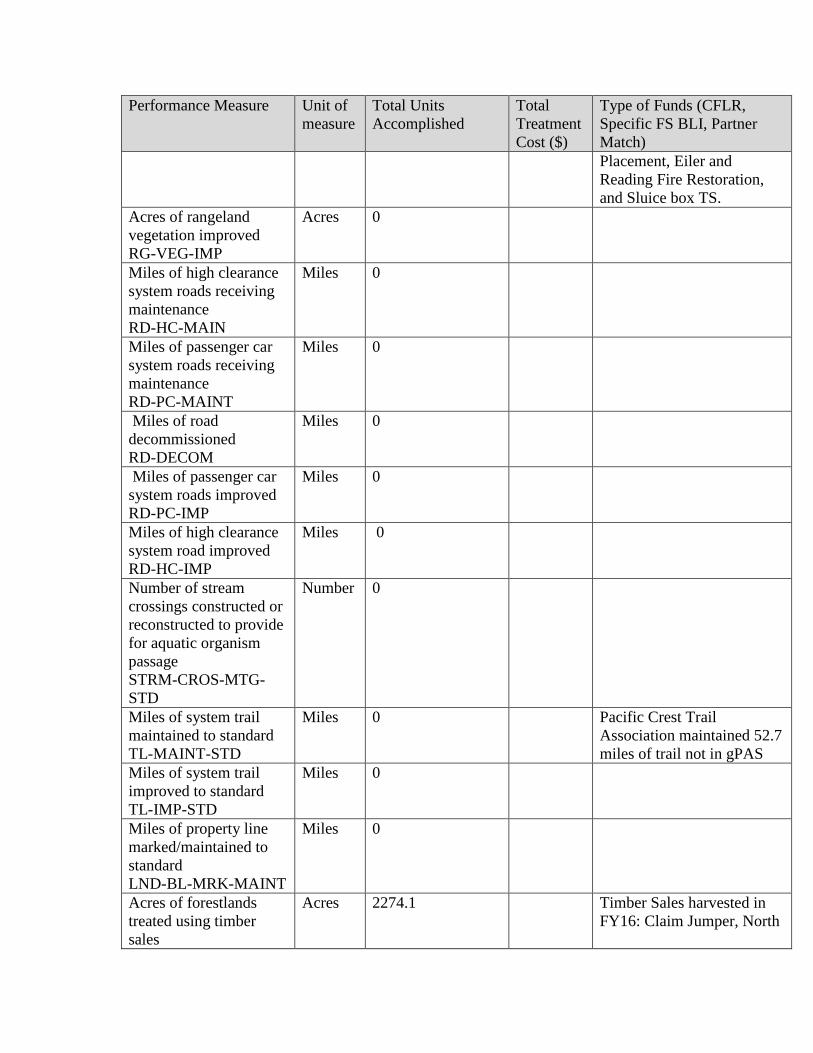
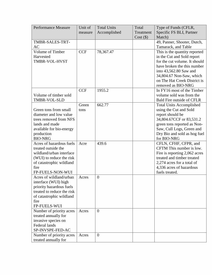
6. FY 2016 accomplishments.
Performance Measure Unit of
measure
Total Units
Accomplished
Total
Treatment
Cost ($)
Type of Funds (CFLR,
Specific FS BLI, Partner
Match)
Acres of forest
vegetation established
FOR-VEG-EST
Acres 1,129.3 149,353 NFVW, RTRT
This should show 1,217
acres.
Acres of forest
vegetation improved
FOR-VEG-IMP
Acres 414.3 CFLN,CWKV
Manage noxious weeds
and invasive plants
INVPLT-NXWD-FED-
AC
Acre 23.3 $6,000 NFWF
Highest priority acres
treated for invasive
terrestrial and aquatic
species on NFS lands
INVSPE-TERR-FED-
AC
Acres 0
Acres of water or soil
resources protected,
maintained or improved
to achieve desired
watershed conditions.
S&W-RSRC-IMP
Acres 422.1 Note: These acres are a
subset of other activities,
there was no direct cost
associated with this
accomplishment.
Acres of lake habitat
restored or enhanced
HBT-ENH-LAK
Acres 0
Miles of stream habitat
restored or enhanced
HBT-ENH-STRM
Miles 0.19
8,000 CFLN A total of 0.19 miles
of stream enhanced along
Hat Creek in the Twin
Bridges area, Bridge
Campground, and Baum
Lake.
Acres of terrestrial
habitat restored or
enhanced
HBT-ENH-TERR
Acres 2710.5 Note: These acres are a
subset of other activities,
there was no direct cost
associated with this
accomplishment. These
activities occurred as a
result of Eastside
Underburn, Cypress
Mastication, and Burney
Meadow Boulder
Performance Measure Unit of
measure
Total Units
Accomplished
Total
Treatment
Cost ($)
Type of Funds (CFLR,
Specific FS BLI, Partner
Match)
Placement, Eiler and
Reading Fire Restoration,
and Sluice box TS.
Acres of rangeland
vegetation improved
RG-VEG-IMP
Acres 0
Miles of high clearance
system roads receiving
maintenance
RD-HC-MAIN
Miles 0
Miles of passenger car
system roads receiving
maintenance
RD-PC-MAINT
Miles 0
Miles of road
decommissioned
RD-DECOM
Miles 0
Miles of passenger car
system roads improved
RD-PC-IMP
Miles 0
Miles of high clearance
system road improved
RD-HC-IMP
Miles 0
Number of stream
crossings constructed or
reconstructed to provide
for aquatic organism
passage
STRM-CROS-MTG-
STD
Number 0
Miles of system trail
maintained to standard
TL-MAINT-STD
Miles 0
Pacific Crest Trail
Association maintained 52.7
miles of trail not in gPAS
Miles of system trail
improved to standard
TL-IMP-STD
Miles 0
Miles of property line
marked/maintained to
standard
LND-BL-MRK-MAINT
Miles 0
Acres of forestlands
treated using timber
sales
Acres 2274.1 Timber Sales harvested in
FY16: Claim Jumper, North
Performance Measure Unit of
measure
Total Units
Accomplished
Total
Treatment
Cost ($)
Type of Funds (CFLR,
Specific FS BLI, Partner
Match)
TMBR-SALES-TRT-
AC
49, Panner, Shooter, Dutch,
Tamarack, and Table
Volume of Timber
Harvested
TMBR-VOL-HVST
CCF 78,367.47 This is the quantity reported
in the Cut and Sold report
for the cut volume. It should
have broken the this number
into 43,562.80 Saw and
34,804.67 Non-Saw, which
on The Hat Creek District is
removed as BIO-NRG
Volume of timber sold
TMBR-VOL-SLD
CCF 1955.2 In FY16 most of the Timber
volume sold was from the
Bald Fire outside of CFLR
Green tons from small
diameter and low value
trees removed from NFS
lands and made
available for bio-energy
production
BIO-NRG
Green
tons
662.77 Total Units Accomplished
using the Cut and Sold
report should be
34,804.67CCF or 83,531.2
green tons reported as Non-
Saw, Cull Logs, Green and
Dry Bio and sold as hog fuel
for BIO-NRG
Acres of hazardous fuels
treated outside the
wildland/urban interface
(WUI) to reduce the risk
of catastrophic wildland
fire
FP-FUELS-NON-WUI
Acre 439.6 CFLN, CFHF, CFPR, and
CFTM This number is low.
Fire is reporting 2,062 acres
treated and timber treated
2,274 acres for a total of
4,336 acres of hazardous
fuels treated.
Acres of wildland/urban
interface (WUI) high
priority hazardous fuels
treated to reduce the risk
of catastrophic wildland
fire
FP-FUELS-WUI
Acres 0
Number of priority acres
treated annually for
invasive species on
Federal lands
SP-INVSPE-FED-AC
Acres 0
Number of priority acres
treated annually for
Acres 0

Performance Measure Unit of
measure
Total Units
Accomplished
Total
Treatment
Cost ($)
Type of Funds (CFLR,
Specific FS BLI, Partner
Match)
native pests on Federal
lands
SP-NATIVE-FED-AC Units accomplished should match the accomplishments recorded in the Databases of Record. Please include the type of Funds (CFLR, Specific
FS BLI, Partner Match) if you have accurate information that is readily available. Please report each BLI on a separate line within a given
performance measures’ “Type of Funds” box.
7. FY 2016 accomplishment narrative – Summarize key accomplishments and evaluate project
progress not already described elsewhere in this report. (Please limit answer to three pages.)
This year’s accomplishments have had a heavy focus on planning, surveying, and salvage timber
sales. Currently, the Plum Project planning is moving forward, and a Proposed Action Purpose
and Need is scheduled for public comment in January 2017. This departure from previous time
lines is due in part to the efforts of District and Forest personnel to complete the NEPA for fire
and windthrow salvages of 2016. The previous success of the project was based on pre-existing
NEPA. The Plum Project will be the first landscape-level project planned in collaboration with
the Burney Hat Creek Community Forest and Watershed Group. Collaborative input has
contributed to the formulation of the project boundaries, the proposed action, and purpose and
need. This project is approximately 18,225 acres, and a NEPA decision is expected in the fall of
2017.
From the collaborative process this year the group developed the Crossroads Project. This project is still in the planning stages, but it will be the first time the District utilizes the Healthy Forest Restoration Act, Categorical Exclusion, treating roughly 2,500 acres. The objective of the project is to reduce hazardous fuels in the WUI and reduce insect induced mortality while maintaining ecosystem function and nutrient resource allocation. Many of the areas selected for treatment within the project boundary are experiencing the effects of drought, climate change, and insect-induced mortality. With the above stressors, many of the stands within the project area are going through the process of type conversion (changes to dominate vegetation type), mainly from a pine-dominated stand to an oak-dominated stand.
This project will have multiple benefits to wildlife through oak enhancement. It will also
increase the resilience of the remaining conifer stand and lower the risk of large fire by reducing
fuels. The project will also create jobs and grant opportunities. Perhaps most importantly,
however, is that this project was designed and developed by the collaborative in partnership with
District staff or personnel and will provide a learning experience for the group in plan
development and the NEPA process. The Crossroads project also benefits from treatments on
adjoining private and state park lands. Together the treatments on public and private lands will
enhance the overall restoration/resilience outcomes on the adjacent communities of Burney,
Johnson Park, and the McArthur Burney Falls State Park.
Planning was completed for the Big Lake Restoration and Enhancement Project.
Implementation will commence in 2017. This project involves the protection, restoration, and
enhancement of two seasonal lakes and associated wetlands. Soil pits were dug to glean the pre-
development boundaries of the wetland systems, and restoration treatments were designed based
on this.
Another key accomplishment this year was the progress made in both surveying and monitoring.
For the projects mentioned above, we are on schedule to have up-to-date surveys on more than
16,000 acres combined. Though some surveys, such as those required by wildlife, are ongoing,
and the results will be of great benefit for the District and the collaborative as we plan ahead for
the future. Additionally, the continued partnership with the USGS, Pit River Tribe, and
University of Nevada, Reno helps us improve our land management decisions and provides us
with critical monitoring infrastructure to improve our hydrologic and aquatic resources
monitoring capabilities..
Eight timber sales were administered on 2,274 acres within the Burney Hat Creek Basin Project
area in FY16. This included one timber sale that completed the harvest of salvage material from
the Reading Fire, two timber sales harvesting salvage material from the Eiler fire, one of which
(Tamarack) is now complete, one small timber sale adjacent to the Table Mountain
Communication site, and four large green timber sales from the North 49 Forest Health Recovery
Project. These eight sales produced a combined 43,562.80 CCF of Saw Timber and 34,804.67
CCF of Non-Saw that processed as 83,531.2 green tons of hog fuel for bio energy. The majority
of the products were harvested, hauled, and processed locally in Shasta County and contributed
positively to the local economic condition.
Service contracts were awarded on 1,214 acres for thinning, piling, mastication, and prescribed
burn preparation including fire line construction. These acres are located within the
Whittington/Cypress Plantation (333 acres), South Station (181 acres), Four Corners (60 acres),
Eiler Fire (281 acres) and North 49 (359 acres) project areas. Implementing such treatments has
been a priority for the Burney-Hat Creek Community Forest and Watershed Group and were
outlined in the project proposal.
A combination of Forest Service dozers, Hat Creek District fire/fuels crews, and off-District fire
resources completed 1,095 acres of thinning, piling, and burn prep within the project area.
Additionally, 1,073 acres within the Eastside Project were underburned, and 495 acres of piles
were burned across the project area.
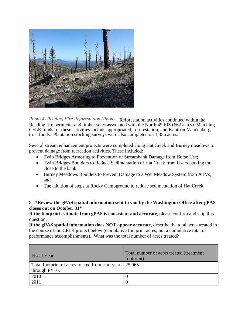
Reforestation activities continued within the Reading fire perimeter and timber sales associated with the North 49 EIS (662 acres). Matching CFLR funds for these activities include appropriated, reforestation, and Knutson-Vandenberg trust funds. Plantation stocking surveys were also completed on 1,356 acres.
Several stream enhancement projects were completed along Hat Creek and Burney meadows to
prevent damage from recreation activities. These included:
Twin Bridges Armoring to Prevention of Streambank Damage from Horse Use;
Twin Bridges Boulders to Reduce Sedimentation of Hat Creek from Users parking too
close to the bank;
Burney Meadows Boulders to Prevent Damage to a Wet Meadow System from ATVs;
and
The addition of steps at Rocky Campground to reduce sedimentation of Hat Creek.
8. *Review the gPAS spatial information sent to you by the Washington Office after gPAS
closes out on October 31*
If the footprint estimate from gPAS is consistent and accurate, please confirm and skip this
question.
If the gPAS spatial information does NOT appear accurate, describe the total acres treated in
the course of the CFLR project below (cumulative footprint acres; not a cumulative total of
performance accomplishments). What was the total number of acres treated?
Fiscal Year
Total number of acres treated (treatment
footprint)
Total footprint of acres treated from start year
through FY16.
25,065
2010
2011
0
0
Photo 4- Reading Fire Reforestation (Photo
by Kori Kelly)

Fiscal Year
Total number of acres treated (treatment
footprint)
2012
2013
2014
2015
2016
4,086
3,879
5,477
5,918
5,705
Please briefly describe how you arrived at the total number of footprint acres: what
approach did you use to calculate the footprint?
Hat Creek Ranger District records for FY2016 within the CFLR area shows the landscape treated
by the following accomplishments.
Accomplishments Acres
Timber Sales 2,274
Service Contracts 1,214
Reforestation (Plant Only) 49
Force Acct 1,095
Rx Fire (Underburn) 1,073
Total 5,705
The treatment footprint in the EDW (Enterprise Data Warehouse) shows that the total extent of the landscape treated using the spatial reporting component of FACTS and WIT is 5,223 acres.
9. Describe any reasons that the FY 2016 annual report does not reflect your project
proposal, previously reported planned accomplishments, or work plan. FY16 projects continue to be delayed by the need to complete restoration work on the 2012 Reading Fire, 2014 Eiler and Bald Fires, and 2015 windthrow event. These competing priorities force us to move planned projects into successive years. The District is still working on utilizing stewardship contracting and is plans to contract an integrated service contract (Sunshine IRSC) and an integrated timber sale contract (Sluice Box IRTC). Although we had planned to contract both projects in FY16, our ongoing salvage efforts have forced us to push them to FY17. We expect to complete sale preparation at the Whittington Forest Heath Restoration project area in FY17 and the sale in FY18; note that this project was originally scheduled during FY15. Fires and other unexpected natural events make it necessary to increase the planning workload and condense the timelines in order to capture economic value and complete restoration work.
10. Planned FY 2018 Accomplishments2
2 Please note that planned accomplishments are aggregated across the projects to determine the
proposed goals for the programs out year budget justification. These numbers should reflect what
is in the CFLRP work plan, with deviations described in question 11.
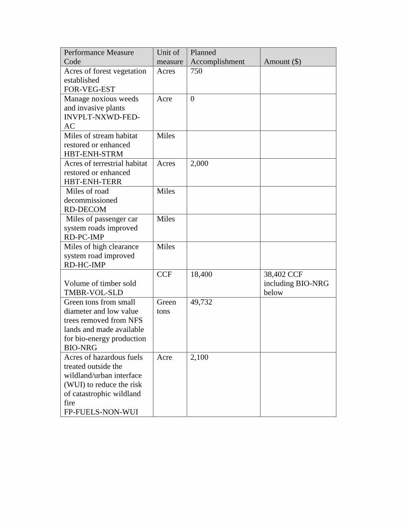
Performance Measure
Code
Unit of
measure
Planned
Accomplishment Amount ($)
Acres of forest vegetation
established
FOR-VEG-EST
Acres 750
Manage noxious weeds
and invasive plants
INVPLT-NXWD-FED-
AC
Acre 0
Miles of stream habitat
restored or enhanced
HBT-ENH-STRM
Miles
Acres of terrestrial habitat
restored or enhanced
HBT-ENH-TERR
Acres 2,000
Miles of road
decommissioned
RD-DECOM
Miles
Miles of passenger car
system roads improved
RD-PC-IMP
Miles
Miles of high clearance
system road improved
RD-HC-IMP
Miles
Volume of timber sold
TMBR-VOL-SLD
CCF 18,400 38,402 CCF
including BIO-NRG
below
Green tons from small
diameter and low value
trees removed from NFS
lands and made available
for bio-energy production
BIO-NRG
Green
tons
49,732
Acres of hazardous fuels
treated outside the
wildland/urban interface
(WUI) to reduce the risk
of catastrophic wildland
fire
FP-FUELS-NON-WUI
Acre 2,100

Performance Measure
Code
Unit of
measure
Planned
Accomplishment Amount ($)
Acres of wildland/urban
interface (WUI) high
priority hazardous fuels
treated to reduce the risk
of catastrophic wildland
fire
FP-FUELS-WUI
Acres 200
Please include all relevant planned accomplishments, assuming that funding specified in the CFLRP project proposal for FY 2017 is available.
Use actual planned funding if quantity is less than specified in CFLRP project work plan. STRM-CROS-MTG-STD has been added since it tends
to be one of the WLSH CFLRP largest funding needs.
11. Planned FY 2017 accomplishment narrative and justification if planned FY 2017/18
accomplishments and/or funding differs from CFLRP project work plan (no more than 1
page):
Planning will be completed on the Crossroads project and continue on the Badger project, both
of which were identified in the Hat Creek-Burney Basins project proposal.
Restoration of the Eiler Fire will continue.
Timber sale operations within the project area will continue in FY18 on timber sales in the North 49 and Whittington project areas. The majority of the products harvested, will continue to be processed locally in Shasta County as both saw logs and Bio-Energy.
12. Please include an up to date list of the members of your collaborative if it has changed from the list you submitted in the FY15
Burney-Hat Creek Community Forest and Watershed Group
Last Name First Name Affiliation
Braugh Drew Fall River Conservancy
Cardenas Daniel Pit River Tribe
Cesmat Deb Lassen National Forest
Budget Officer
Coppoletta Michelle Lassen National Forest
Curtis Don Hat Creek Fire Safe
Council
Danheiser Crystal Lassen National Forest
Del Bene Terry Pit River Tribe
Dolan Michael Bureau of Land
Management
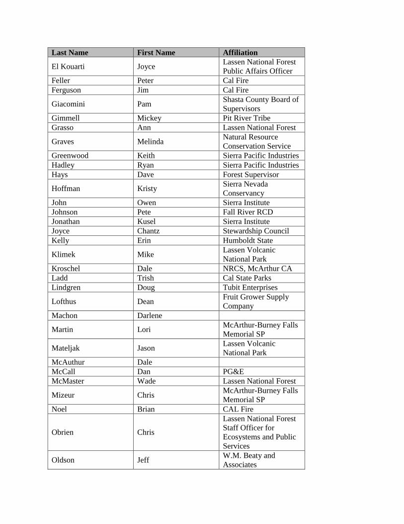
Last Name First Name Affiliation
El Kouarti Joyce Lassen National Forest
Public Affairs Officer
Feller Peter Cal Fire
Ferguson Jim Cal Fire
Giacomini Pam Shasta County Board of
Supervisors
Gimmell Mickey Pit River Tribe
Grasso Ann Lassen National Forest
Graves Melinda Natural Resource
Conservation Service
Greenwood Keith Sierra Pacific Industries
Hadley Ryan Sierra Pacific Industries
Hays Dave Forest Supervisor
Hoffman Kristy Sierra Nevada
Conservancy
John Owen Sierra Institute
Johnson Pete Fall River RCD
Jonathan Kusel Sierra Institute
Joyce Chantz Stewardship Council
Kelly Erin Humboldt State
Klimek Mike Lassen Volcanic
National Park
Kroschel Dale NRCS, McArthur CA
Ladd Trish Cal State Parks
Lindgren Doug Tubit Enterprises
Lofthus Dean Fruit Grower Supply
Company
Machon Darlene
Martin Lori McArthur-Burney Falls
Memorial SP
Mateljak Jason Lassen Volcanic
National Park
McAuthur Dale
McCall Dan PG&E
McMaster Wade Lassen National Forest
Mizeur Chris McArthur-Burney Falls
Memorial SP
Noel Brian CAL Fire
Obrien Chris
Lassen National Forest
Staff Officer for
Ecosystems and Public
Services
Oldson Jeff W.M. Beaty and
Associates
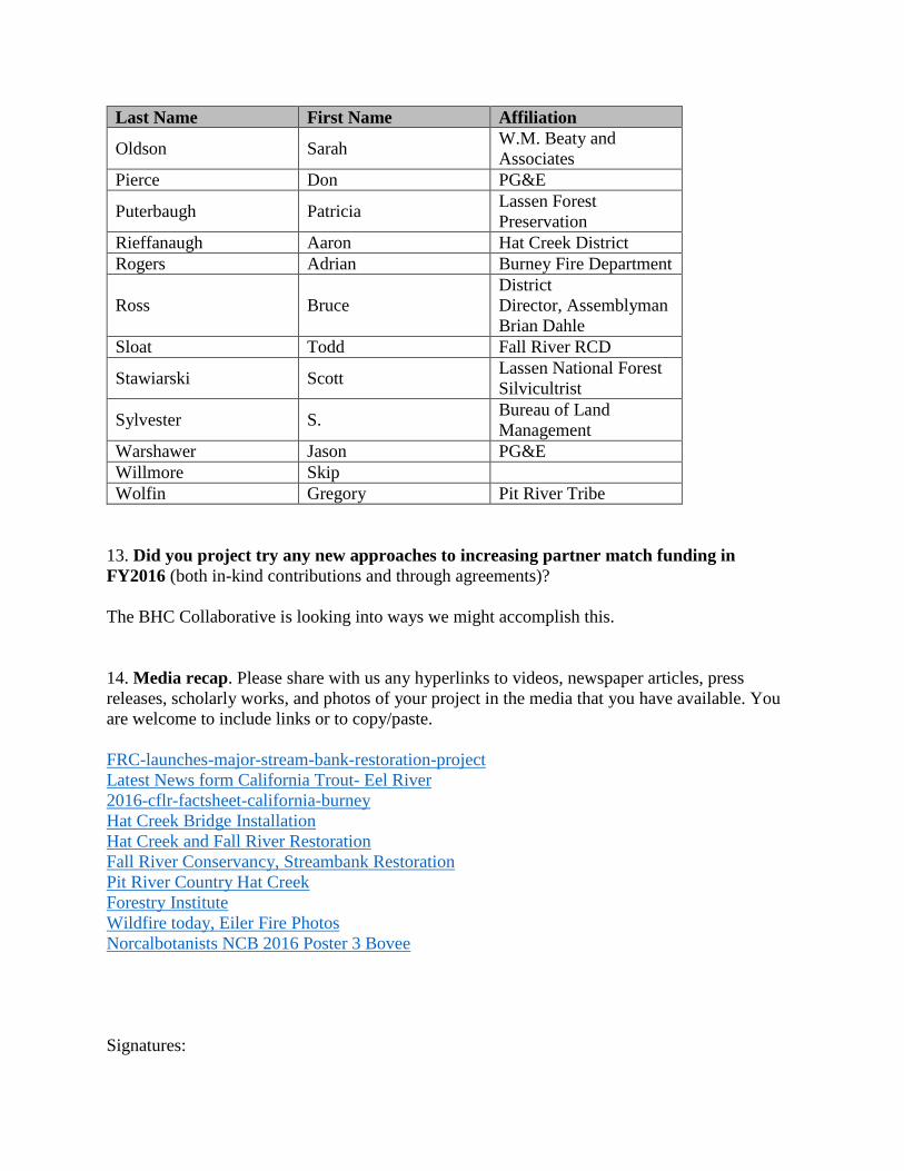
Last Name First Name Affiliation
Oldson Sarah W.M. Beaty and
Associates
Pierce Don PG&E
Puterbaugh Patricia Lassen Forest
Preservation
Rieffanaugh Aaron Hat Creek District
Rogers Adrian Burney Fire Department
Ross Bruce
District
Director, Assemblyman
Brian Dahle
Sloat Todd Fall River RCD
Stawiarski Scott Lassen National Forest
Silvicultrist
Sylvester S. Bureau of Land
Management
Warshawer Jason PG&E
Willmore Skip
Wolfin Gregory Pit River Tribe
13. Did you project try any new approaches to increasing partner match funding in
FY2016 (both in-kind contributions and through agreements)?
The BHC Collaborative is looking into ways we might accomplish this.
14. Media recap. Please share with us any hyperlinks to videos, newspaper articles, press
releases, scholarly works, and photos of your project in the media that you have available. You
are welcome to include links or to copy/paste.
FRC-launches-major-stream-bank-restoration-project
Latest News form California Trout- Eel River
2016-cflr-factsheet-california-burney
Hat Creek Bridge Installation
Hat Creek and Fall River Restoration
Fall River Conservancy, Streambank Restoration
Pit River Country Hat Creek
Forestry Institute
Wildfire today, Eiler Fire Photos
Norcalbotanists NCB 2016 Poster 3 Bovee
Signatures:

Recommended by: /s/ Greg Mayer
Approved by (Forest Supervisor): /s/ Dave Hays
(OPTIONAL) Reviewed by (collaborative chair or representative): ____________________