cfaa 2014 marland mill exc v2 - institutional...
TRANSCRIPT

1
© CfAA: Archaeological Evaluation of the Leat: Marland Mill Farm April 2014 (14)
Archaeological Excavation Of the Leat at Marland Mill Farm, Rochdale Client: Wheeldon Brothers Waste Ltd Technical Report: Andrew McGuire & Dr M Nevell
Report No: 14/2014

2
© CfAA: Archaeological Evaluation of the Leat: Marland Mill Farm April 2014 (14)
Site Location: Marland Mill Farm, Rochdale Internal Ref: CfAA/14/2014 . Project: Marland Mill excavation Planning Ref: N/A Prepared for: Wheeldon Brothers Waste Ltd Document Title: Archaeological Excavation of the leat at Marland Mill Farm, Rochdale Document Type: Technical report Version: Version 1 Authors: Dr Michael Nevell Date: 31/03/2014 Approved by: Adam Thompson Signed.................................... Position: Director of Archaeological Services Date: 31/03/2014 Copyright: Copyright for this document remains with the Centre for Applied
Archaeology, University of Salford. Contact: Centre for Applied Archaeology, University of Salford, Joule House, 1 Acton
Square, Crescent, Salford, Greater Manchester, M5 4DW Telephone: 0161 295 3825
Email: [email protected] Disclaimer: This document has been prepared by the Centre for Applied Archaeology, University of Salford for the titled project or named part thereof and should not be used or relied upon for any other project without an independent check being undertaken to assess its suitability and the prior written consent and authority obtained from the Centre for Applied Archaeology. The University of Salford accepts no responsibility or liability for the consequences of this document being used for a purpose other than those for which it was commissioned. Other persons/parties using or relying on this document for other such purposes agrees, and will by such use or reliance be taken to confirm their agreement to indemnify the University of Salford for all loss or damage resulting there from. The University of Salford accepts no liability or responsibility for this document to any other party/persons than by whom it was commissioned.

3
© CfAA: Archaeological Evaluation of the Leat: Marland Mill Farm April 2014 (14)
Contents
Summary 4 1. Introduction 5 2. The Setting 6 3. Archaeological & Historical Background 7 4. Methodology 11 5. Archaeological Descriptions and Results 12 6. Archaeological Results 13 7. Discussion 20 8. Archive 23 9. Acknowledgements 24 10. Sources 16 Appendix 1: Context List 18 Appendix 2: Illustrations 20

4
© CfAA: Archaeological Evaluation of the Leat: Marland Mill Farm April 2014 (14)
Summary
This report presents the results of an archaeological evaluation at Marland Mill, Rochdale, in January 2014. Marland Mill lies in a small valley adjacent to the Sudden Brook, at a height of c. 111m AOD. A desk-based assessment and building survey in 2013 identified the site as having origins as a medieval corn mill, which was re-used for the textile industry in the mid-19th century. The line of a leat used as a tail race for the mill was identified during this initial work. This feature will be affected by development to the north of the mill building. The evidence from the three evaluation trenches shows that the leat was a stone-lined and covered culverted, and is still preserved and functioning within the study area. The evidence from T1 showed a stone covered water source that, when damaged, flooded the entire western end of the trench. T2 and T3 also highlighted the continuation of this structure throughout the southern field. It seems likely that the present form of the leat dates from the 19th century when the corn mill was converted to textile uses and the leat covered over. Until the mid-19th century this has been an open feature.

5
© CfAA: Archaeological Evaluation of the Leat: Marland Mill Farm April 2014 (14)
1. Introduction
1.1 Background This report presents the results of an archaeological evaluation at Marland Mill, Rochdale in January 2014. Marland Mill lies in a small valley adjacent to the Sudden Brook, at a height of c. 111m AOD (Fig. 1). A desk-based assessment and a building survey of the mill structures were undertaken in 2013 (Nevell & Isherwood 2013). Due to the site’s current land usage, excavation had to be completed, recorded and backfilled within one day. Furthermore, the wet ground conditions restricted this excavation work.

6
© CfAA: Archaeological Evaluation of the Leat: Marland Mill Farm April 2014 (14)
2. The Setting
2.1 Location Marland Mill lies in a small valley adjacent to the Sudden Brook, at a height of c. 111m AOD. The local drift geology is boulder clay, overlying a solid geology of Bunter Sandstone, now known as Sherwood Sandstone (http://www.bgs.ac.uk). To the east of the site lie alluvial sands and gravels associated with the River Sudden, which flows into the River Roch to the north. The mill buildings were in use in the autumn of 2013 as stables on the ground floor, and general storage on the upper floors at the time of the desk-based assessment and building survey (Fig 2). 2.2 Personnel The project was conducted and supervised by professional archaeologists from the Centre of Applied Archaeology. Onsite excavations were conducted by Andrew McGuire and Adam Thompson. This report and associated illustrations were written and compiled by Andrew McGuire and Michael Nevell. The project was managed by Adam Thompson.

7
© CfAA: Archaeological Evaluation of the Leat: Marland Mill Farm April 2014 (14)
3. Archaeological & Historical Background
3.1 Introduction
The following descriptions form an appropriate and accurate reflection of the current state of knowledge of the archaeological and historical development of the study area and are based upon the archaeological desk-based assessment and building survey undertaken by the Centre in 2013.
3.2. Medieval Period During the medieval period the study area lay within the Castleton district of the parish of Rochdale (Farrer & Brownbill 1911, 199-200). Marland was a separate manor by the early 13th century, when a grant of six oxgangs of land by Roger de Lacy was confirmed in 1212 on Stanlaw Abbey (Farrer & Brownbill 1911, 201). The abbey continued to hold land in the manor until its dissolution in the late 1530s when it was confiscated by the Crown (Farrer & Brownbill 1911, 201-6). The earliest reference to a watermill on the Sudden Brook and close to Marland is in a grant of land and rights in a mill from Johannes de Lascy (John de Lacy, Constable of Chester) to the Cistercian abbey at Stanlaw (Hulton 1847b, 602). This grant must have been made between 1178, when the monastery was founded by John de Lacy, and 1190, the year of his death. The mill is described as a watermill at Sudden between the villages of Marland and Castleton. Between 1190 and 1220 (dating determination, King 1991, 127) Robert of Flamborough sold to the same monks his right in Sudden Mill and lands at Castleton, Rochdale (Hulton 1847b, 599; Maxim 1913, 7). Sudden Mill is also recorded in a land transfer witnessed by Robert of Flamborough at around the same time period (ibid, 629). The next direct reference to the mill comes in the Rochdale Manor survey of 1626. At this time the mill was included in the landholdings of Robert Holte. The entry reads:
"Three other tenements consisting of ar. mead. & past with a Water Corne Mill standg uppon ...adjoing West & North upon Marland" (Fishwick 1913, 2).
There are strong possibilities that the mill may have been associated with, or had connections to, the Cistercians of Whalley Abbey who had an active presence in the locality. In 1296, the abbot of Stanlaw and his monks moved and took possession of Whalley (Hulton 1847a, viii). Marland had been one of the earliest acquisitions of the abbey of Stanlaw (Farrer and Brownbill 1911, 202) and it is recorded that at the time of the move to Whalley, two monks, Father Ricus de Sutton and Father Henry Storesworth, were appointed to the Grange of Marland (Whitaker 1801, 52-3). 3.3 Post-Medieval Period After the dissolution, the significant abbey holdings at Marland were granted by the crown to Thusrton Tildesley and Edward Jackman in 1541. These holdings of 720 acres included much arable and pasture land as well as the well-stocked fish pond of Marland Mere itself. These holdings were subsequently sold to Robert Holt of Castleton Hall in 1631 (Fishwick 1913, 14-16; Hulton 1847b, 590). In the late 17th and 18th centuries the manor continued to be held by

8
© CfAA: Archaeological Evaluation of the Leat: Marland Mill Farm April 2014 (14)
the Holt family. The site of the Grange is not known nor is the site of the chapel at Marland which was marked on John Speed's Map of Lancashire 1610 and Bowen's Map of Lancashire 1752. In 1726 Marland Mill is clearly described as a water corn mill and is in the possession of Samuel Chetham. A lease dated 6th July 1726 requires the lessee of tenements called 'Cockers' and 'Collinge' in Castleton, Robert Heape, to "...come to the water corn Milne of the said Samuel Chetham, called Marland Milne, with all such corn and graine as shall yearly growe renew or be spent..." (Heape 1905, 80). The Castleton Poor Lay Records (RLSL LA/Z/1/C3) state in the first lay assessed on 24th May 1780 that James Kershaw is rated fifteen shillings for ‘Marland Mill and kiln’. He is also rated ten shillings fourpence ha'penny for ‘house and land’ and one pound and six pence for ‘Marland Eyes’. The Castleton Township Vestry Accounts (Poor Rate) (RLSL LA/Z/1/C4) make an assessment for Mr James Walmsley or occupiers in respect of Marland Mill, house, land and Marland Eyes for the last part of 1799 and the first part of 1800. 3.4 Industrial Period By the late 18th century Rochdale was industrialising quickly and dozens of cotton and woollen textile mills were established on the tributaries of the river Roch by 1800 (Nevell 2008). The nearby Sudden Mills, which lies c.250 to the east of the study area on Sudden Brook, dates from this period (GMHER 5082.1.0). The late 18th and early 19th centuries also saw the establishment of a turnpike network into and out of Rochdale, as its industrial role increased. One of the roads turnpiked was Bolton Road, immediately south of the study area, where a milestone can still be seen on the roadside from this period(GMHER 2374.1.0) along with a road bridge (GMHER 2392.1.0), Suddenbridge. The earliest map showing the location of the watermill within the study area (GMHER 16128.1.02) is W. Yates map of Lancashire which was surveyed in the 1770s and published in 1786. The map shows the mill on the western side of the Rochdale to Manchester road at the point where the road crosses the Sudden Brook. At this point, water was taken from the Sudden Brook to fill a small reservoir which supplies the watermill and is shown on the map immediately to the south. A tail race fed this back into the Sudden Brook. Yates’ map also shows a building north-west of the mill which is probably the current stone farmhouse, which is shown on the 19th and 20th century OS mapping. The watermill is also marked and named as Marland Mill on Hennet's Map of Lancashire, surveyed 1828-9. In a topographical account of the Rochdale area published in 1828, Marland Mill is recorded as Sudden Mill and its long-standing historical records through association with Whalley Abbey are mentioned (Butterworth 1828, 142). Baines’ History and Directory of Lancashire Volume Two for the year 1825 names Jonathon Crowther as a corn miller at Marland Mill. A variety of directories (Pigot 1838, Slater 1843, 1848, 1851 and Whellan 1852) all identify Joseph Holden as a corn miller at Marland Mill. The Castleton Household Survey of 1831 (RLSL R942) lists three households at Marland Mill. The first household is of a single female, Susan Holden. The second household consists of two males and one female, the householder being named as James Kershaw whose profession is 'carter'. The third household consists of two males and two females, the householder being named as Joseph Holden whose profession is named as 'corn dealer'.

9
© CfAA: Archaeological Evaluation of the Leat: Marland Mill Farm April 2014 (14)
The 1841 national census records four households at Marland Mill (HO 107 / 550 / 10). Two of the householders are described as agricultural labourers, one householder as a farmer and the other householder, Joseph Holden, as a corn miller. Joseph Holden's business interests would appear to be thriving as his family employed two resident female servants. Also, William Kershaw, the twelve year old son of one of the householders is also described as a corn miller, presumably employed at Joseph Holden's mill. Map evidence in relation to the Marland Mill site is strong for the period between the censuses of 1841 and 1851. The Castleton Township map of c1844 (RLSL LA/Z/3/C; Fig 3) and the OS first edition map surveyed 1844-7 (Fig 4) show similar detail. Two linked reservoirs are situated on the south-eastern side of the main mill building to the west of the Windmill Inn at Sudden Bridge. The township map labels the mill as 'Marland Flour Mill' and the OS map as 'Marland Mill (corn)'. The schedule for the township map identifies Joseph Holden as being both owner and occupier of the mill and surrounding buildings, the reservoirs and the fields to the west of the mill extending to the hamlet at Marland. The main mill building does not fully match that shown on the OS map of 1890-1 (Fig 5), indicating that the mill was significantly altered sometime and expanded between 1844 and 1891. The inscribed date-stone on the building which currently occupies the site (JH 1847) suggests that Joseph Holden was undertaking building work on the site around 1847. The 1844 Castleton Township map also shows the line of the tail race, a trackway to the north, a west to east footpath and boundary going over the tail race, a further field boundary to the south, and the farmhouse to west of the mill, shown as an L-shaped structure. In addition the 1844-7 ordnance Survey map shows a footpath along the river and two bridges across the tail race. It would seem, however, that activity in relation to corn milling was still taking place on the site after 1847. The 1851 national census records three households at Marland Mill (HO 107 / 2244 p31). The first householder is a hatter (presumably employed at the nearby and recently established Castleton Silk works). The second householder is the son of the farmer named 1841. His farm is described as covering 39 acres. The third householder is Joseph Holden still described as a corn miller and employing five men. This evidence is matched by directory evidence from Slater 1851 and Whellan 1852. Activity relating to corn milling would appear to end on the site between 1852 and 1861. The 1861 national census records a single household at Marland Mill, that of Joseph Holden (RG 9 / 3034, p22). He is now described as a master cotton spinner employing 18 men, 20 women and six boys. Slater's Directory of 1861 lists within the section 'Cotton Spinners' - 'Holden, Joseph - Marland Mill. Joseph Holden died in 1864. Around this time, the Holden family built the large residence of High Birch on former agricultural land belonging to them above the mill site and to the west. Joseph's wife, son and daughter were living there in 1871. The 1890-1 OS map shows a very large building extending over the Sudden Brook, in the area that is now vacant, to the east of the present building dated 1847. The building is named as ‘Marland Dye Works’. Part of, or all of this building may relate to the commencement of cotton spinning on the site by Joseph Holden between 1852 and 1861. Evidence from commercial directories is limited for these major changes. Slater's Directory of Lancashire 1871-2 has the following entry – ‘Castleton Spinning and Manufacturing Co. Ltd., Marland Mill, Marland; Buckley Clarkson, manager’. The following entry from the Rochdale and District Commercial Directory for 1888-9 may also relate to the site – ‘Dyers, Bleachers and Finishers - Smith, James and Sons Ltd., (Yarn Dyers), John Street and at Marland’. Worrall’s Cotton Spinners’ and Manufacturers’ Directory for Lancashire from 1891 lists the Marland Dye Works, Nixon Street, Castleton as belonging to James Smith & Sons.

10
© CfAA: Archaeological Evaluation of the Leat: Marland Mill Farm April 2014 (14)
On 26th December 1892 the mill reservoirs at Marland Dye Works were the scene of a tragic accident. The Rochdale Observer brought out a special edition on Tuesday 27 December 1892 to report the drowning of four skaters when the ice broke underneath around an estimated 200 skaters who were on the ice. This event may well have contributed to the ending of commercial activity on the site. The reservoirs were filled in soon after the drownings and part of the tail race covered. The OS map of 1910 show the large Dye Works building had also been removed with just the current L-shaped arrangement of buildings left on the site. The 20th century landscape-use of the site focussed on Marland Farm and the farmhouse, which was extended. One of the field boundaries was removed during this period, a small farmyard building demolished and a garage built. Access to the farm remained via the trackway from Bolton Road, despite the construction of suburban housing in the period 1957/8 to 1977/9, as recorded by the Ordnance Survey maps of those years.

11
© CfAA: Archaeological Evaluation of the Leat: Marland Mill Farm April 2014 (14)
4. Methodology
4.1 Excavation Methodology Three evaluation trenches (Fig 2, 6-7) were located across the line of the leat as recorded by the desk-based assessment in 2013, where it would be impacted by the development. These were excavated using a mechanical digger with a 1.6m wide toothless ditching bucket. The machine excavations were supervised by a professional archaeologist at all times. The evaluation trenches were located to determine the presence, extent, depth and state of preservation of the remains identified by the archaeological Desk-Based Assessment associated with the leat that formed the tail race of the mill. After machine excavation had taken place, all further excavations proceeded by hand. Excavated spoil was placed at least 1.00m from the edge of each trench and spoiled on one side only. All material removed during the excavation was used to backfill the trenches, then machine tamped. 4.2 Recording Methodology Separate contexts were recorded individually on (CfAA) pro-forma context sheets (Appendix 1). In this report all fills and layers are contained within rounded brackets (***) and all features and cuts are in square brackets [***].Plans and sections were recorded on CfAA pro-forma drawing sheets at an appropriate scale of 1:10, 1:20, or 1:50, depending on the complexity of the data and features encountered. All drawings were individually identified and cross referenced, contexts enumerated and principal layers and features annotated with OD level information. Photography of all relevant phases and features was undertaken with digital formats. General working photographs were taken during the duration of the archaeological works, to provide illustrative material covering the wider aspects of the archaeological work undertaken.
All finds were recorded by context and significant “small finds” located within three dimensions to the nearest 10mm were bagged and labelled separately. All fieldwork and recording of archaeological features, deposits and artefacts was carried out to acceptable archaeological standards.

12
© CfAA: Archaeological Evaluation of the Leat: Marland Mill Farm April 2014 (14)
5. Archaeological Descriptions & Results
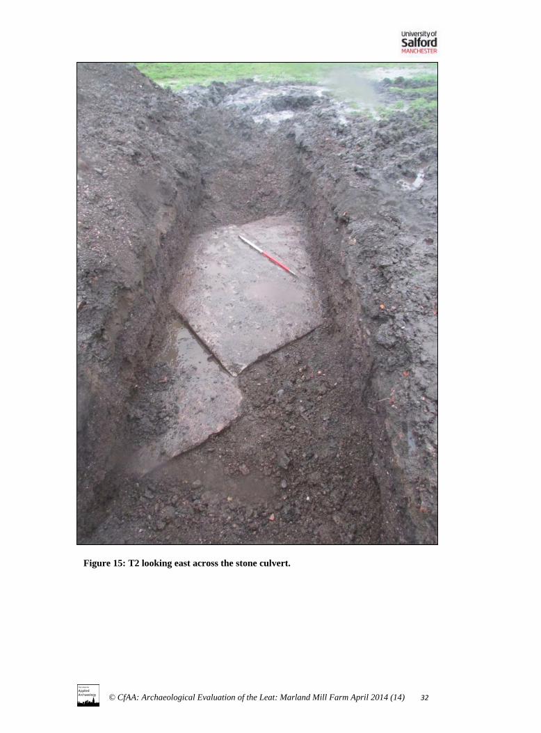
5.1 Trench 1 (Fgs 6-14) T1 was located at around SD 88103 12002 over the line of the leat, and was 1.60m x 18.00m. Orientated roughly west to east, the northern edge was 5.00m from the northern fence line and the eastern edge was 15.00m from the eastern fence line. It was excavated to roughly 1.00m throughout (1.20m at 6-7.00m). At its western end, beyond 11.50m, it was excavated to a depth of 1.50m. A possible leat cut [007] was observed at around 7.00m from the eastern edge of the trench and roughly 0.60m below current ground level. Beyond this within the trench towards the east only natural sand and pebble shale deposits encountered, concurrent with riverine geology. Possibly due to a high water table, at 1.00m below surface, ground water was observed in base of trench. Drawings show contexts associated with [007]. Below the base of (005), flooding occurred. It was noted that sediment beneath (005) was displaced during machining and the water course, observed later in T3, began to flow into the western end of the trench. A possible return of cut [007] and fill (006) were observed in the trench section beyond (005) as flooding occurred. However the speed at which the trench flooded, eventually causing section collapse, meant this was not recorded. At 16.00m a possible field drain was observed in section. This was still functioning and added to the flooding at this end of the trench. Excavation halted just beyond this extent. 5.2 Trench 2 (Figs 15-16) T2 was located at around SD 88114 11958 over the line of the leat and was orientated roughly north-west to south-east (a change from WSI due to drainage issues and surface water). The trench measured 6.00m x 1.60m. The south-eastern edge was roughly 30.00m south-west of the eastern edge of the southern fence line and 1.00m north-west of that point. It was excavated to 1.00m as excavation beyond that depth in T1 resulted in flooding of the trench. The top of the stone culvert (009) was recorded seen at this depth, with fills (008) noted as a similar deposit to (004). 5.3 Trench 3 (Figs 17-19) T3 was located at around SD 88114 11977 and was orientated roughly west to east. This was an additional trench to the WSI excavated at the request of the developer and agreed to by CfAA as a compromise to the limited excavation of T2. This was only recorded photographically due to time constraints but highlighted the possible leat structure as being preserved between T1 and T2. A stone slab/flag from the culvert (012) was dislodged during excavation allowing the still functioning water course to be observed beneath. The cut [010] was similar to [007] and similar fills (011) were also observed to (004) seen in the section of T1.

13
© CfAA: Archaeological Evaluation of the Leat: Marland Mill Farm April 2014 (14)
6. Discussion The evaluation excavation works have confirmed the course of the leat, as noted in the 2013 desk-based assessment (Nevell & Isherwood 2013). The evidence from the three evaluation trenches shows that the leat was a stone-lined and covered culverted, and is still preserved and functioning within the study area. The evidence from T1 showed a stone covered water source that, when damaged, flooded the entire western end of the trench. T2 and T3 also highlighted the continuation of this structure throughout the southern field. It seems likely that the present form of the leat dates from the 19th century when the corn mill was converted to textile uses and the leat covered over. Until the mid-19th century this has been an open feature. Trench 1 was found to contained a cut which can be associated with this earlier phase of leat structure, although there was no evidence for its date.

14
© CfAA: Archaeological Evaluation of the Leat: Marland Mill Farm April 2014 (14)
7. Archive Location
The archive comprises annotated field drawings, digital and colour positive photographs. This archive is currently held by the Centre for Applied Archaeology and a copy of this report will be forwarded to Rochdale Metropolitan Borough Council following the publication of the site report. A copy of this report will be deposited with the Greater Manchester Sites and Monuments Record held by the Greater Manchester Archaeological Advisory Service .

15
© CfAA: Archaeological Evaluation of the Leat: Marland Mill Farm April 2014 (14)
8. Acknowledgements
The Centre for Applied Archaeology would like to thank AGMA for commissioning the archaeological works. CfAA would also like to thank Norman Redhead for providing monitoring support and advice through GMAAS. Also Mick Nightingale and Michael Dunne at Bury Council for their support and active participation during the project. Onsite excavations were conducted by Brian Grimsditch, Sarah Cattell, and Vicky Nash with the help and support of over 150 local community volunteers and 10 local schools. The Centre would also like to thank the minister and congregation of the Parish Church of St Mary’s, Radcliffe for their support and the use of the church building and graveyard. This report was written, compiled and illustrated by Sarah Cattell and Dr Michael Nevell and managed by Adam Thompson.

16
© CfAA: Archaeological Evaluation of the Leat: Marland Mill Farm April 2014 (14)
Sources
Primary Sources RLSL LA/Z/1/C3 Castleton Poor Lay Records, 1780-5. RLSL LA/Z/1/C4 Castleton Township Vestry Accounts (Poor Rate) 1799-1800. RLSL LA/Z/3/C Castleton Township Survey nd c1844. RLSL LA/Z/3/C/2 Schedule for the Township Survey of Castleton [c1844]. RLSL - Rochdale Local Studies Library. Secondary Sources Brennand M, with Chitty G & Nevell M, (eds), 2007, Research and Archaeology in North
West England. An archaeological Research Framework for North West England: Volume 2 Research Agenda and Strategy. Association of Local Government Archaeological Officers North West and English Heritage with the Council for British Archaeology North West.
Butterworth, J., 1828, An Historical and Topographical Account of the Town and Parish of Rochdale in Lancashire. Manchester.
English Heritage, 2010, English Heritage Thematic Research Strategies: A Thematic Research Strategy for the Historic Industrial Environment. English Heritage, Swindon, July 2010.
Farrer, W. and Brownbill, J. (eds.) 1911, A History of the County of Lancashire. Volume 5. Victoria County History. Constable.
Fishwick, H., (ed.), 1913, The Survey of the Manor of Rochdale in the County of Lancaster. Made in 1626. Manchester: Chetham Society.
Heape, C. and Heape, R., 1905, Records of the Family Heape - of Heape, Staley, Saddleworth and Rochdale from c1170 to 1905. Rochdale: James Clegg, The Aldine Press.
Hulton, W.A. (ed.), 1847a, The Coucher Book or Chartulary of Whalley Abbey. Volume 1. Manchester: Chetham Society.
Hulton, W.A. (ed.), 1847b, The Coucher Book or Chartulary of Whalley Abbey. Volume 2. Manchester: Chetham Society.
King, C.D., 1991, The Whalley Coucher Book and the Dialectal Phonology of Lancashire and Cheshire, 1175-1350. Unpublished thesis submitted for the degree of Doctor of Philosophy in the University of St. Andrews.
Maxim, J.L., 1913, Water Corn Mills in Rochdale and District. Transactions of the Rochdale Literary and Scientific Society, Vol. XII, 1914-6, p1-12.
Nevell M, (ed.), From Farmer to Factory Owner: Models, Methodology and Industrialisation. CBA North West & the University of Manchester archaeology Unit, Manchester.
Nevell M & Isherwood R, 2013, Archaeological Desk-Based Assessment: Marland Mill Farm, Rochdale. Unpublished NPPF client report by the Centre for Applied Archaoelogy, University of Salford.
Miller, I, 2012, An Industrial Art: The Archaeology of Calico Printing in the Irwell Valley. Lancaster: Oxford Archaeology.
NPPF 2012, National Planning Policy Framework, Department for the Environment, March 2012.
Nevell M & Isherwood R, 2013, Archaeological Desk-based Assessment, Marland Mill, Rochdale. Unpublished client report, University of Salford CfAA.
Palmer M, Nevell M & Sissons M, 2012, Industrial Archaeology: A Handbook. York: Council for british Archaeolgy Practical Handbook 21.
Watts M, 2008, Corn Milling. Stroud: Shire Library.

17
© CfAA: Archaeological Evaluation of the Leat: Marland Mill Farm April 2014 (14)
Whitaker, T.D., 1801, The History of the Original Parish of Whalley, and Honor of Clitheroe, in the Counties of Lancaster and York. Blackburn: Hemingway and Crook.
Newspapers Rochdale Observer Trade Directories Baines' History and Directory of Lancashire, Vol. 2 1825. Pigot's Directory of Manchester and Salford 1838 Slater's Directory of Manchester and Salford 1843. Slater's Royal National Commercial Directory 1848 Slater's Directory of Manchester and Salford 1851. Whellan's Directory of Manchester and Salford 1852. Slater's Royal national Commercial Directory of Manchester and Liverpool 1861. Slater's Directory of Lancashire 1871-2. Rochdale and District Commercial Directory 1888-9. Maps and Plans John Speed's Map of Lancashire, 1610. Bowen’s Map of Lancashire 1752. W.Yates Map of Lancashire surveyed 1770s, published 1786. G. Hennet's Map of the County Palatine of Lancashire, surveyed 1828-9, published 1830. OS 6 inch to 1 mile First edition, Lancashire Sheet 88, surveyed 1844-7, published 1851. OS 1:2500 Lancashire Sheet First Edition 1893 LXXXVIII. 8, surveyed 1890-1, published
1893. OS 1:2500 Lancashire Sheet Edition of 1910, LXXXVIII. 8, surveyed 1908, published 1910. OS 1:2500 series 1957-8 edition, SD 88 11. Web Sources British Geological Survey: http://www.bgs.ac.uk, (accessed 11/12/2012).

18
© CfAA: Archaeological Evaluation of the Leat: Marland Mill Farm April 2014 (14)
Appendix 1: Context List
Context No.
Trench Context Description
(001) 1 Topsoil (002) 1 Plough soil (003) 1 Mid-brown loam – landscaping layer? (004) 1 Loam and silt fill (005) 1 Stone culvert (006) 1 Silty dark grey fill [007] 1 Leat cut (008) 2 Loam and silt fill (009) 2 Stone culvert [010] 3 Leat cut (011) 3 Loam and silt fill (012) 3 Stone culvert

19
© CfAA: Archaeological Evaluation of the Leat: Marland Mill Farm April 2014 (14)
Appendix 2: Illustrations
Figure 1. The location of study area at Marland Mill Farm (arrowed). Scale 1:50000. Reproduced from modern OS mapping by permission of Ordnance Survey on behalf of the Controller of Her Majesty’s Stationary Office. Crown Copyright . All rights reserved. Licence number: 100050261.

© CfAA: Archaeological Evaluation of the Leat: Marland Mill Farm April 2014 (14) 20
Figure 2. The location of evaluation trenches at Marland Mill Farm (labelled). Scale 1:1250. Reproduced from modern OS mapping by permission of Ordnance Survey on behalf of the Controller of Her Majesty’s Stationary Office. Crown Copyright . All rights reserved. Licence number: 100050261.

© CfAA: Archaeological Evaluation of the Leat: Marland Mill Farm April 2014 (14) 21
Figure 3: The Marland Mill Farm study area on the 1844 Castleton Township map (outlined in red approxinately) showing the line of the leat.

© CfAA: Archaeological Evaluation of the Leat: Marland Mill Farm April 2014 (14) 22
Figure 4: The Marland Mill Farm study area on the OS 1844-7 six inch map (outlined in red) showing the line of the leat.

© CfAA: Archaeological Evaluation of the Leat: Marland Mill Farm April 2014 (14) 23
Figure 5: The Marland Mill Farm study area on the OS 1891 25 inch map (outlined in red) showing the line of the leat.

© CfAA: Archaeological Evaluation of the Leat: Marland Mill Farm April 2014 (14) 24
Figure 6: Excavated plan of T1 showing the location of the stone-lined and covered leat.

© CfAA: Archaeological Evaluation of the Leat: Marland Mill Farm April 2014 (14) 25
Figure 7: Excavated section of T1 showing the top of the stone-lined leat, and the earlier leat cut line..

© CfAA: Archaeological Evaluation of the Leat: Marland Mill Farm April 2014 (14) 26
Figure 8: The location of T1 as viewed from Marland Mill.

© CfAA: Archaeological Evaluation of the Leat: Marland Mill Farm April 2014 (14) 27
Figure 9: T1 looking west.

© CfAA: Archaeological Evaluation of the Leat: Marland Mill Farm April 2014 (14) 28
Figure 10: Detail of the western end of T1 looking at the cut and silt marking the line of the leat.

© CfAA: Archaeological Evaluation of the Leat: Marland Mill Farm April 2014 (14) 29
Figure 11: Detail of the leat cut [007] and silt (006).
Figure 12: Detail of the leat cut [007] and silt (006) in relation to the stone capping (005).

© CfAA: Archaeological Evaluation of the Leat: Marland Mill Farm April 2014 (14) 30
Figure 13: T1 looking east.

© CfAA: Archaeological Evaluation of the Leat: Marland Mill Farm April 2014 (14) 31
Figure 14: T1 looking west across the stone culvert (005).
© CfAA: Archaeological Evaluation of the Leat: Marland Mill Farm April 2014 (14) 32
Figure 15: T2 looking east across the stone culvert.

© CfAA: Archaeological Evaluation of the Leat: Marland Mill Farm April 2014 (14) 33
Figure 16: T2 showing the top of the culvert.

© CfAA: Archaeological Evaluation of the Leat: Marland Mill Farm April 2014 (14) 34
Figure 17: T3 looking north.
Figure 18: T3 looking at the top of the culvert (012).

© CfAA: Archaeological Evaluation of the Leat: Marland Mill Farm April 2014 (14) 35
Figure 19: T3 looking at the silts and water within the culvert.