central waterfront land uses1
TRANSCRIPT
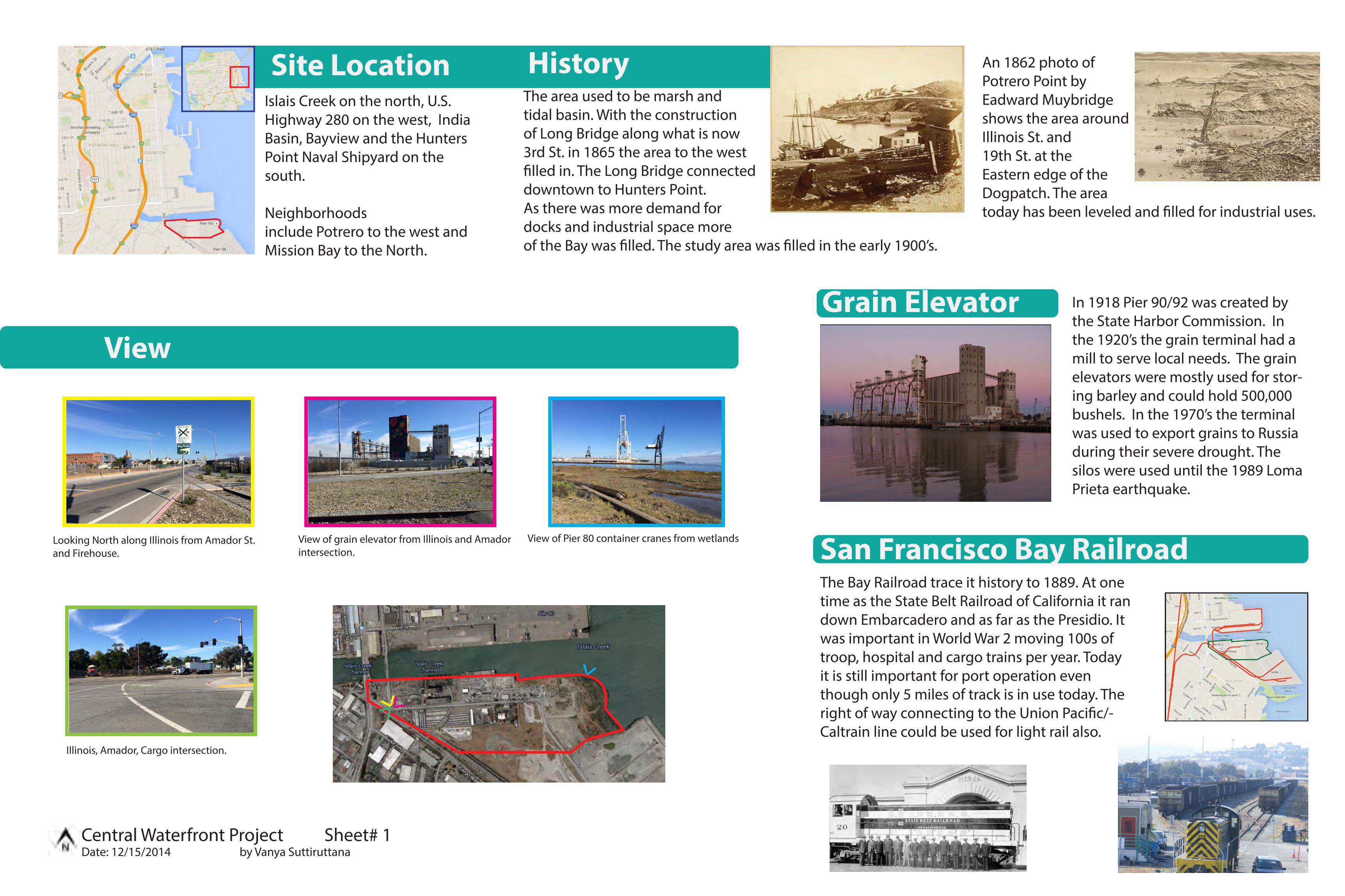
Site LocationIslais Creek on the north, U.S. Highway 280 on the west, India Basin, Bayview and the Hunters Point Naval Shipyard on the south.
Neighborhoods include Potrero to the west and Mission Bay to the North.
HistoryThe area used to be marsh and tidal basin. With the construction of Long Bridge along what is now 3rd St. in 1865 the area to the west �lled in. The Long Bridge connecteddowntown to Hunters Point.As there was more demand fordocks and industrial space moreof the Bay was �lled. The study area was �lled in the early 1900’s.
In 1918 Pier 90/92 was created by the State Harbor Commission. In the 1920’s the grain terminal had a mill to serve local needs. The grain elevators were mostly used for stor-ing barley and could hold 500,000 bushels. In the 1970’s the terminal was used to export grains to Russia during their severe drought. The silos were used until the 1989 Loma Prieta earthquake.
Grain Elevator
San Francisco Bay RailroadThe Bay Railroad trace it history to 1889. At one time as the State Belt Railroad of California it ran down Embarcadero and as far as the Presidio. It was important in World War 2 moving 100s of troop, hospital and cargo trains per year. Today it is still important for port operation even though only 5 miles of track is in use today. The right of way connecting to the Union Paci�c/-Caltrain line could be used for light rail also.
An 1862 photo of Potrero Point by Eadward Muybridge shows the area around Illinois St. and 19th St. at the Eastern edge of the Dogpatch. The area today has been leveled and �lled for industrial uses.
VV
V
View of grain elevator from Illinois and Amador intersection.
Looking North along Illinois from Amador St.and Firehouse.
View of Pier 80 container cranes from wetlands
Illinois, Amador, Cargo intersection.
View
V
Central Waterfront Project Sheet# 1Date: 12/15/2014 by Vanya Suttiruttana

T
19
48
ZoningCensus
Change in populationsince 2000
Over 20% decline
-10% to -20%
0% to -10%
0% to 10%
10% to 20%
Over 20% increase
Westerly WindTra�c Noise
Sun Path
Environmental Factors
The area has prevaling westerly winds.
Most of the site has good southern exposure which provides opportunity for solar power.
There is background tra�c noise from 280 and 3rd street.There is also noise from aggregate operation.
1 mile radius from 3305 3rd St.166 vehicle thefts and break-ins between 10/20/2013-10/20/2014
The area is not developed yet so the crime rate is low compared to the areas around it. These vehicle crime statistics show the need for secured parking.
Crime Type Summary
Crime Types by Day Of Week
71
Motor Vehicle Theft (95)
Vehicle Break-In/Theft (71)
Auto Theft
Central Waterfront Project Sheet# 2Date: 12/15/2014 by Vanya Suttiruttana

Circulation
T
T
T
T
T
T
T
T
48
48
48
T22
22
22
19
44
Van Ness and SunnydaleFisherman’s Wharf and Hunters Point
Richmond and Hunters Point
Zoning
Parks & Openspace
The blue greenway project is the improvement of the southern portion of the Bay Trail. This section runs along the bay however our section does not because of the working port. Since it will be converted to PDR and residential there is an opportunity to connect the Pier 94 Wetland to the Bay
Restaurants
Night Life
Shopping
Actives Life Art & Entertainment
Beauty & Spa
Groceries
Cafe
AmenitiesPublic Services
Fire Stations
Schools
Postal O�ces
Librarys
Fire station #24 located on 3rd St. and postal service located on Burke Ave are close to the site. The closest elementary school Malcolm X Elementary and Anna E. Waden library are in Bayview district. Both library and the school are about 1 mile away.
Central Waterfront Project Sheet# 3Date: 12/15/2014 by Vanya Suttiruttana
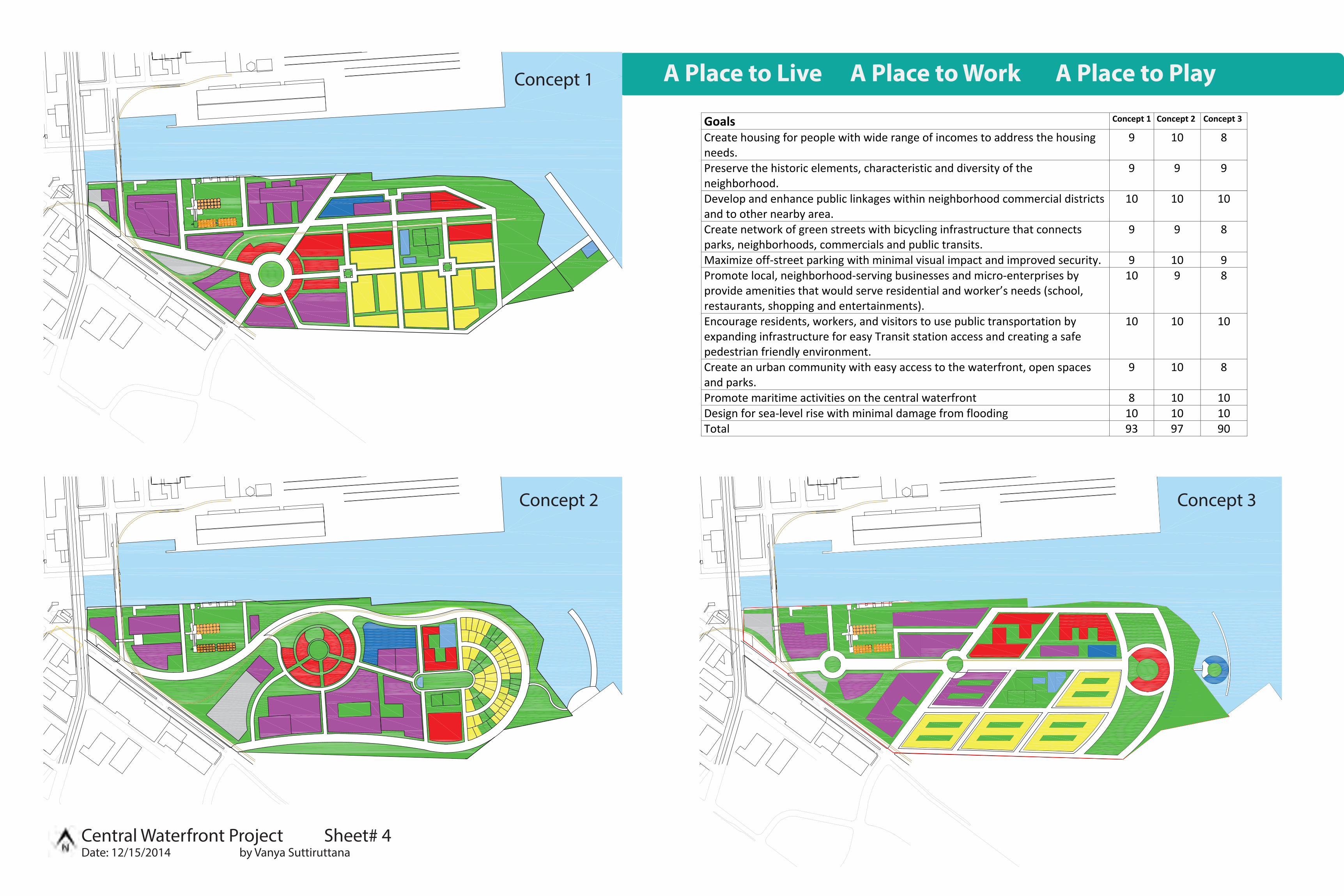
Goals Concept 1 Concept 2 Concept 3
Create housing for people with wide range of incomes to address the housingneeds.
9 10 8
Preserve the historic elements, characteristic and diversity of theneighborhood.
9 9 9
Develop and enhance public linkages within neighborhood commercial districtsand to other nearby area.
10 10 10
Create network of green streets with bicycling infrastructure that connectsparks, neighborhoods, commercials and public transits.
9 9 8
Maximize off street parking with minimal visual impact and improved security. 9 10 9Promote local, neighborhood serving businesses and micro enterprises byprovide amenities that would serve residential and worker’s needs (school,restaurants, shopping and entertainments).
10 9 8
Encourage residents, workers, and visitors to use public transportation byexpanding infrastructure for easy Transit station access and creating a safepedestrian friendly environment.
10 10 10
Create an urban community with easy access to the waterfront, open spacesand parks.
9 10 8
Promote maritime activities on the central waterfront 8 10 10Design for sea level rise with minimal damage from flooding 10 10 10Total 93 97 90
A Place to Live A Place to Work A Place to PlayConcept 1
Concept 2 Concept 3
Central Waterfront Project Sheet# 4Date: 12/15/2014 by Vanya Suttiruttana

Residence HighDensity @1200sf
Floor Square Footageper Floor
Total Units
B:1 2 15,525 31,050 26B:2 2 12,217 24,434 20B:3 2 16,872 33,744 28B:4 2 20,400 40,800 34B:5 2 9,447 18,894 16B:6 2 7,449 14,898 12B:7 2 8,583 17,166 14B:8 2 12,625 25,250 21B:10 2 36,050 72,100 60B:11 4 20,642 82,568 68D:1 5 9,641 48,205 40D:2 6 15,606 93,636 78
19,200 115,200 95Total 512
Residence LowDensity
Floor Square Footageper Floor
Total Units
C:1@1356 4 2,034 8,136 6C:2@1,953 5 5,860 6
@2,925 6C:3@1,476 6 8,855 53,130 36C:4@1,891 5 5,674 6
@2,925 6C:5@1953 4 2,141 8,565 6E:1@1736 3 11,574 34,722 20E:2@2023 3 11,464 34,392 17E:3@1650 3 11,000 33,000 20E:4@1581 3 14,233 42,699 27E:5@1598 3 10,120 30,360 19E:6@1622 3 19,925 56,775 35E:7@1684 3 24,692 74,079 44E:8@1730 3 18,455 55,365 32E:9@1814 3 26,609 79,827 44E:10@1828 3 32,286 96,858 53E:11@1879 3 25,050 75,150 40F:1@1600 4 20,863 83,452 52
@1400 4 15,943 63,772 45Total 520
Land Use
Parking Spaces
Research &Development
Floor Square Footage perfloor
Total
A:1 4 28,786 115,114A:2 4 50,917 183,668A:3 4 48,930 185,720A:4 5 66,037 330,185
4 50,143 200,5723 38,910 116,730
A:5 3 30,761 92,2832 4,565 9,130
A:6 4 69,335 277,3401 18,147 18,147
A:7 4 57,055 228,2201 20,590 20,590
A:8 3 81,177 243,5312 29,953 59,906
Total 2,081,136
Retail Square Footage Hotel Square FootageB:2 13,945 A 208,544B:3 19,276 B 260,320B:4 24,049 Community Center 10,476B:5 10,311 Museum 45,574B:6 7,756 Entertainment Center 84,584B:7 9,102B:8 14,409B:9 6,350B:10 41,872B:11 20,642E:9 11,610Total 227,484
Central Waterfront Project Sheet# 5Date: 12/15/2014 by Vanya Suttiruttana

Bicycle System Primary Street Section
Secondary Streets Section
Bicycle access is provided for all road ways in the development area. Mostly this is by dedicated bike lanes and a bike route. Bike infrastructure connects to the existing bike lanes on Illinois and Cargo. Cargo provides access to 3rd Street where a bike route continues. Bike lanes access all the o�ce develop-ments and connect to light rail and the ferry terminal for easy commuter access to mass transit.
To the right are street sections for the primary and secondary streets. The pri-mary streets encompass the boundary road which encircles the site and the south access road. An example layout for the four lane roads is shown in sec-tion A:1. The south access road has on street parking as a bu�er and a bike lane adjacent to the tra�c lane as shown in section A:2. The secondary streets are for local tra�c therefore there is only one tra�c lane in each di-rection. An example layout is shown in section A:3. `
Section A:1-6
Section A:2-6
Section A:3-6
Bike LaneBike RouteExisting BikeLane
6’ 5’ 6’ 6’5’
5’5’5’5’ 5’ 5’ 5’ 5’5’ 5’
5’ 5’5’ 5’5’
11’ 11’
11’
11’ 11’12’
11’ 11’
11’ 8’5’12’
6’
Illinois St
Cargo St
3rd St
Scale 1” = 300’
Scale 1/8” = 1’
8’
Central Waterfront Project Sheet# 6Date: 12/15/2014 by Vanya Suttiruttana
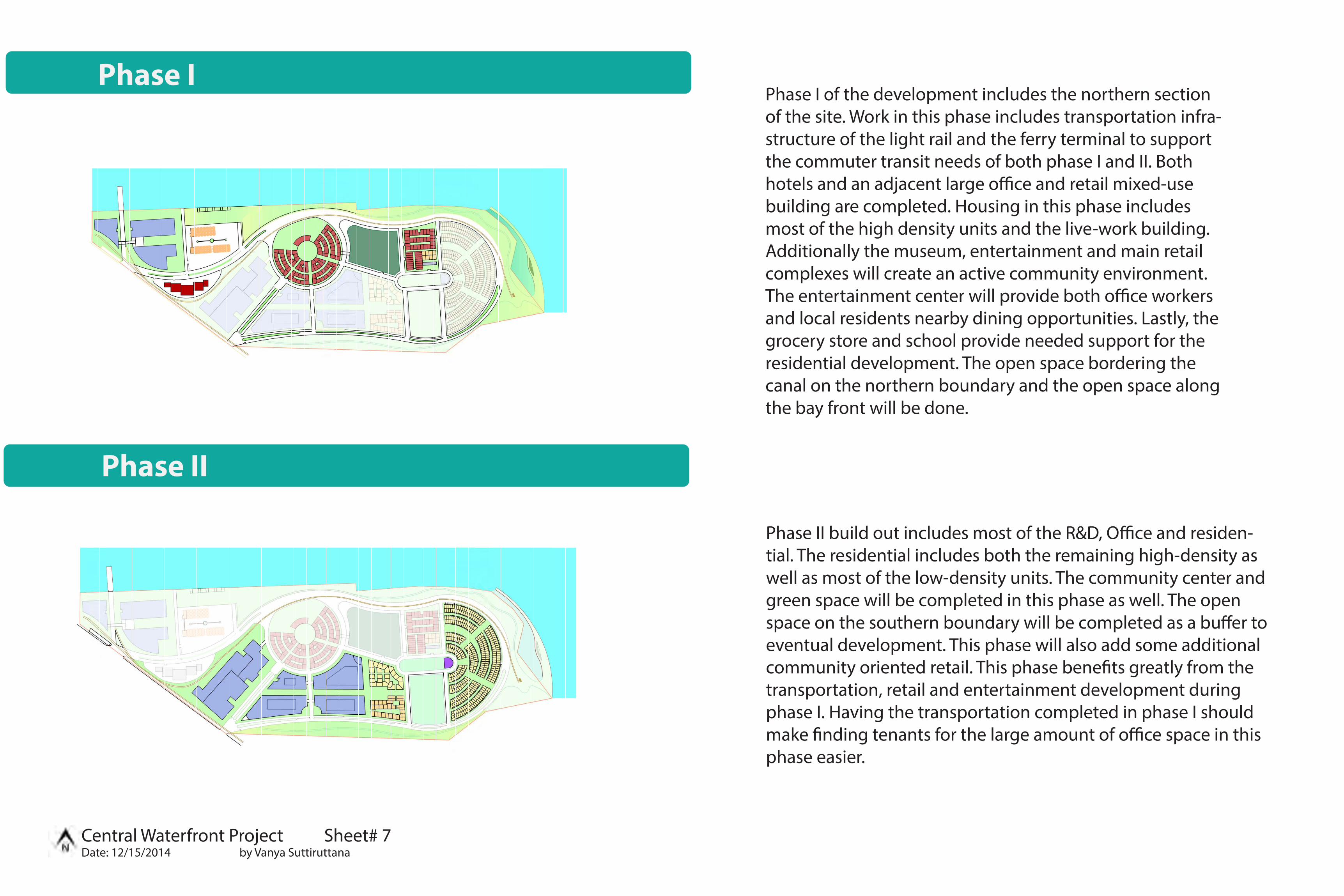
Phase I
Phase II
Phase I of the development includes the northern section of the site. Work in this phase includes transportation infra-structure of the light rail and the ferry terminal to support the commuter transit needs of both phase I and II. Both hotels and an adjacent large o�ce and retail mixed-use building are completed. Housing in this phase includes most of the high density units and the live-work building. Additionally the museum, entertainment and main retail complexes will create an active community environment. The entertainment center will provide both o�ce workers and local residents nearby dining opportunities. Lastly, the grocery store and school provide needed support for the residential development. The open space bordering the canal on the northern boundary and the open space along the bay front will be done.
Phase II build out includes most of the R&D, O�ce and residen-tial. The residential includes both the remaining high-density as well as most of the low-density units. The community center and green space will be completed in this phase as well. The open space on the southern boundary will be completed as a bu�er to eventual development. This phase will also add some additional community oriented retail. This phase bene�ts greatly from the transportation, retail and entertainment development during phase I. Having the transportation completed in phase I should make �nding tenants for the large amount of o�ce space in this phase easier.
Central Waterfront Project Sheet# 7Date: 12/15/2014 by Vanya Suttiruttana

Central Waterfront Project
Central Waterfront Project Sheet# 8 Scale: 1” = 100’Date: 12/15/2014 by Vanya Suttiruttana
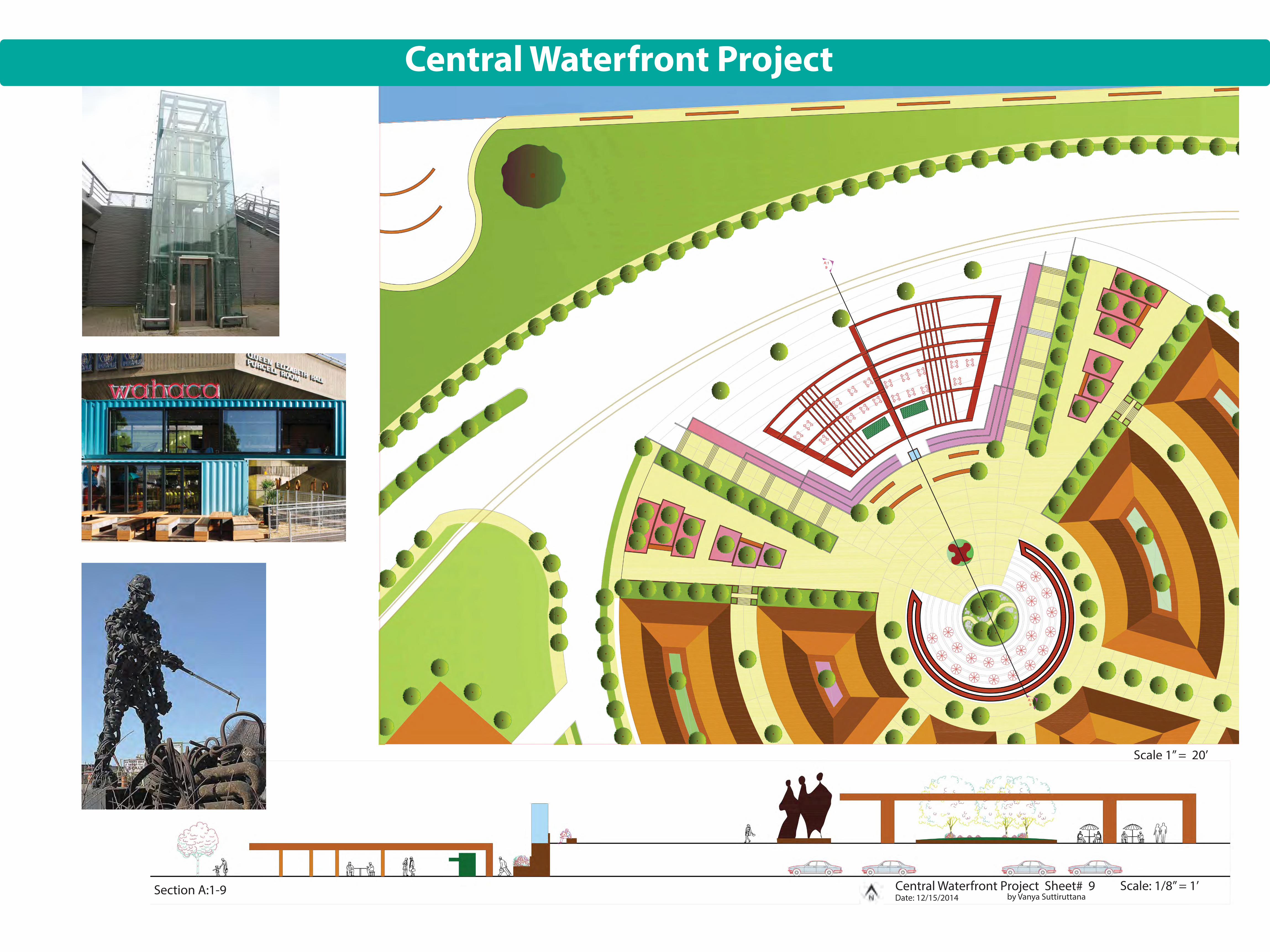
Scale 1” = 20’
Central Waterfront Project Sheet# 9 Scale: 1/8” = 1’Date: 12/15/2014 by Vanya Suttiruttana
Central Waterfront Project
A:19
A:19
Section A:1-9

Weekend Community Events Silo Hotels and Commuter Ferry
Neighborhood Park Wetland Openspace