catmdedit – metadata editor - sourceforge
TRANSCRIPT

Advanced InformationSystems Laboratory GeoSpatiumLab S.L.
CatMDEdit – Metadata editor
University of ZaragozaComputer Science and Systems Engineering DepartmentAdvanced Information Systems Laboratory (IA3)http://iaaa.cps.unizar.es/
GeoSpatiumLab S.L.http://www.geoslab.com/

Outline
IntroductionCapabilitiesConclusions

Introduction
CatMDEdit is a metadata editor tool that facilitates the documentation of resources, with special focus on the description of geographic information resourcesGeneral features:
Developed in JavaDistributed as Open Source tool through SourceForge.net(http://catmdedit.sourceforge.net/) Multi-platform (Windows, Unix)
Storage of metadata records managed directly through the file system
MultilingualCurrently: Spanish, English, French, Polish, Portuguese and Czech versionContributors are welcome for customization to other languages

Capabilities
Definition and management of repositoriesMetadata edition in conformance with different metadata standards and profiles
ISO19115 and its profilesDublin CoreCustomization to support new standards and profiles
Tools to facilitate the edition of metadataOn-line description of standards and profilesContact directory, thesaurus repository Selection of geographic extentAutomatic metadata generationDescription of content information through feature catalogues
Exchange of metadata recordsFormats for encoding and presentation
Connection to data management applications

Definition and management of repositories
CatMDEdit is a content management tool The content is organized in different repositories
Each repository contains a series of resourcesA resource is the basic information unit which consists of data plus metadata
Currently repositories correspond to folders of the file system,but other storage mechanism could be implemented (databases, ftp, …)
Resource BrowserMain window of CatMDEditIt allows the management of repositories and resources

Resource Browser – Management of repositories

Resource Browser – Management of resources - list
Different viewers: list, thumbnails, geographic selector

Resource Browser – Management of resources - thumbnails

Resource Browser – Management of resources – geographic selector
Possibility of generatinga GeoRSS file to be uploadedin external applications likeGoogleMaps, OpenLayers, …

Metadata edition in conformace with ISO19115
Metadata edition in conformance with "ISO19115. Geographic Information - Metadata" standardEdition interfaces adapted to different metadata profiles:
ISO19115 comprehensive metadata model ISO19115 Core metadata for geographic datasets NEM ("Núcleo Español de Metadatos") metadata profile
Defined by the Spanish National Geographical High Board ("Consejo Superior Geográfico") for the minimum description of datasets
Draft INSPIRE implementing rules for metadata and their correspondence with the standard ISO19115WISE metadata profile
customized to meet the guidelines for metadata in the implementation of the Water Framework Directive and the development of the “Water Information System for Europe”(WISE).

Metadata edition in conformace with ISO19115
On-line description of standards and profiles
definitionexamplesobligation
Metadata validationCheck incomplete elements….
Colour Description
Mandatory
Conditional (mandatory if applicable)
Optional

Metadata edition in conformace with ISO19115
Metadata edition in conformance with the Dublin Core metadata standard (ISO 15836). This tool follows the guidelines for expressing Dublin Core metadata using the Resource Description Framework

Customization to support new standards and metadata profiles
Customization of the tool to support new standards and metadata profiles according to user needs. Examples:
Plan Nacional de Ortofotografía Aerea (PNOA)National Plan for Aerial Ortophotography
Sistema de Información de Ocupación del Suelo En España (SIOSE)Information System for Land Use in Spain
Both projects requirethe cooperation of local authorities for producing tiles of the national productdefine profiles of ISO19115, restricting the number of elements and values to be filled

Tools to facilitate the edition of metadata
Contact directoryThesaurus repositorySelection of geographic extentAutomatic metadata generation: data formats, spatial collectionsDescription of content information through feature catalogue

Contact directory
Contact information (e.g. name, address, telephone…) is required in many metadata elements (creator, publisher, contributor ...)Contact directory allows the reuse of contact information

Thesaurus repository
In some cases, standards specify/recommend a metadata element to be filled with a controlled vocabulary (codelist, thesaurus)CatMDEdit integrates a thesaurus management tool [see ThManager]
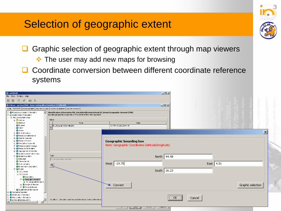
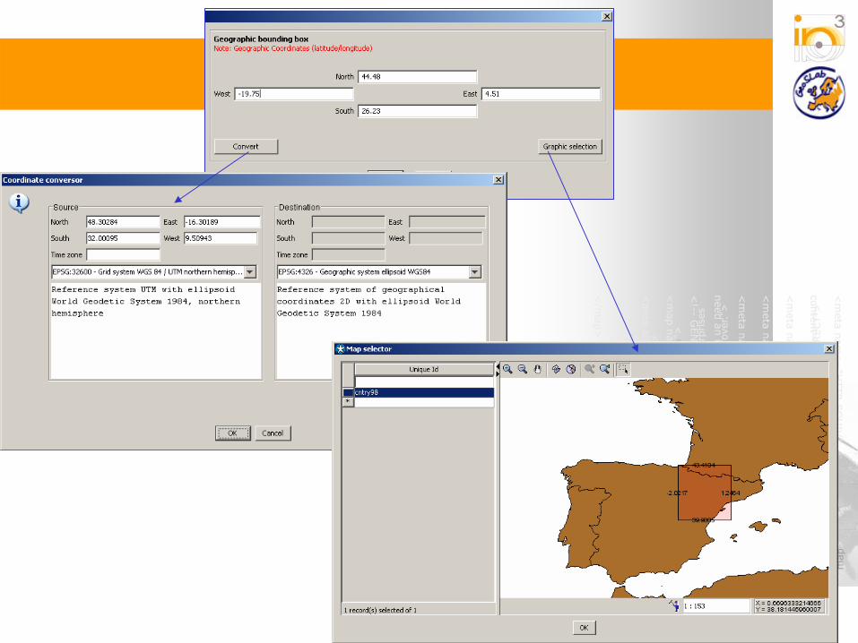
Selection of geographic extent
Graphic selection of geographic extent through map viewersThe user may add new maps for browsing
Coordinate conversion between different coordinate reference systems
Automatic metadata generation
Automatic metadata generation for some data file formats
Shapefile, DGN, ECW, FICC, GeoTiff, GIF/GFW, JPG/JGW, PNG/PGW
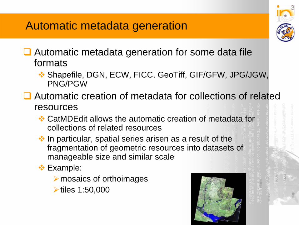
Automatic creation of metadata for collections of related resources
CatMDEdit allows the automatic creation of metadata for collections of related resourcesIn particular, spatial series arisen as a result of the fragmentation of geometric resources into datasets of manageable size and similar scale Example:
mosaics of orthoimagestiles 1:50,000

Automatic metadata generation for some data file formats
ISO 19115 metadata elements SHP DGN ECW FICC GeoTIFF GIF/ GFW JPG/ JGW PNG/ PGW
MD_Metadata.identificationInfo> MD_DataIdentification.spatialRepresentationType X X X X X X X X
MD_Metadata.identificationInfo> MD_DataIdentification.extent>
EX_Extent.geographicElement X X X X X X X X
MD_Metadata.contentInfo> MD_FeatureCatalogueDescription.featureType X X X
MD_Metadata.applicationSchemaInfo> MD_ApplicationSchemaInformation.schemaAscii X
MD_Metadata.spatialRepresentationInfo> MD_VectorSpatialRepresentation.geometricObjects X X X
MD_Metadata.spatialRepresentationInfo> MD_GridSpatialRepresentation. numberOfDimensions axisDimensionProperties
X X X X X
MD_Metadata.distributionInfo> MD_Distribution.transferOptions>
MD_DigitalTransferOptions.onLine> CI_OnlineResource.linkage
X X X X X X X X
MD_Metadata.distributionInfo> MD_Distribution.transferOptions>
MD_DigitalTransferOptions.transferSize X X X X X X X X
MD_Metadata.distributionInfo> MD_Distribution.distributionFormat>
MD_Format.name X X X X X X X X
Automatic creation of metadata for collections of related resources
Steps to be followedActivate functionality while creating a repositoryDescribe the spatial series
Select metadata that will describe the general features of the collection, shared among the componentsSelect the spatial pattern that explains the spatial distribution of the components in the collection
o <Shapefile + DBF> that will dictate the geographic extent of the collection and the specific features of each component
Customize the generation of metadata records describing each component in the collection
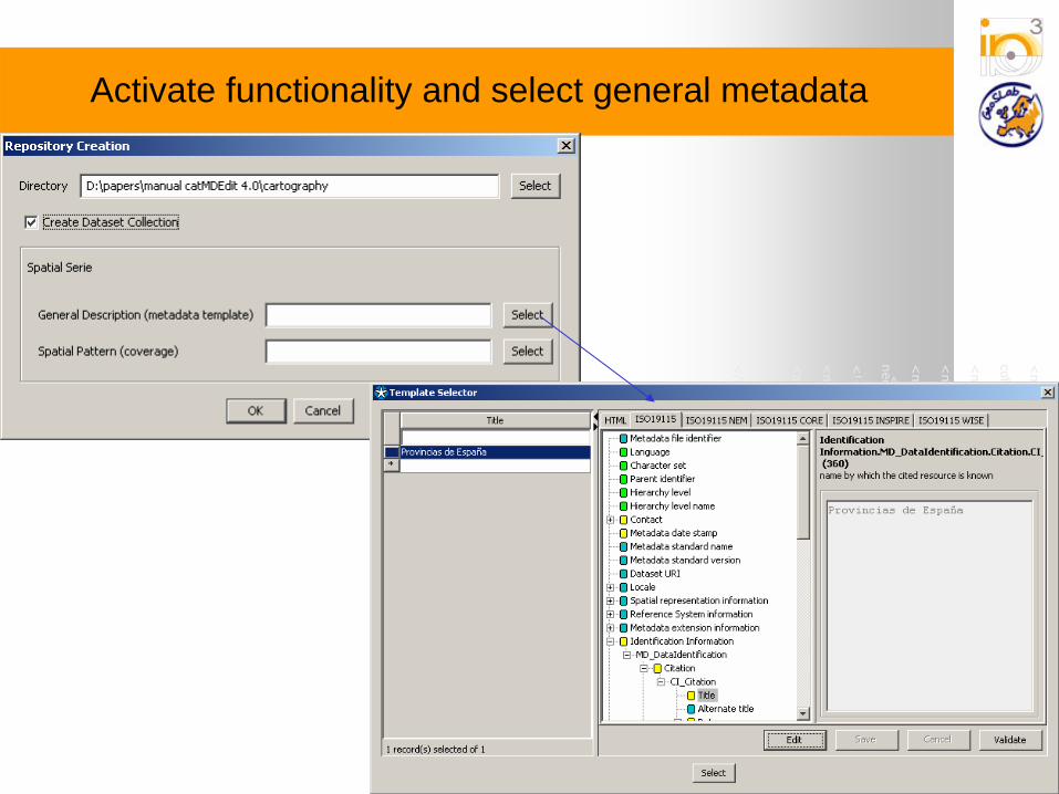
Activate functionality and select general metadata

Select the spatial pattern
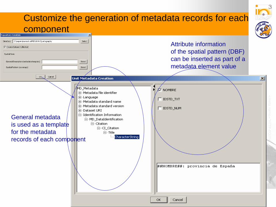
Customize the generation of metadata records for each component
Attribute informationof the spatial pattern (DBF)can be inserted as part of a metadata element value
General metadatais used as a templatefor the metadatarecords of each component

Final layout of the repositoryExample: Collection of resources following the spatial distibution of provinces in Spain
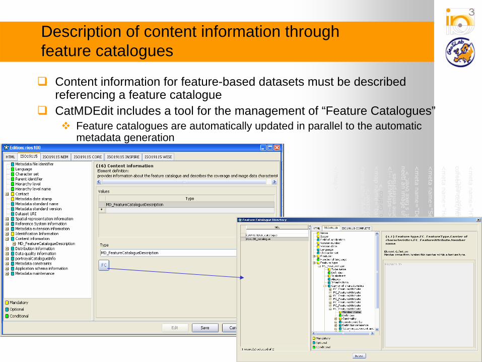
Description of content information through feature catalogues
Content information for feature-based datasets must be described referencing a feature catalogueCatMDEdit includes a tool for the management of “Feature Catalogues”
Feature catalogues are automatically updated in parallel to the automatic metadata generation

Exchange of metadata records
Exchange of metadata records according to different standards inXML and RDF:
XML format in compliance with the ISO19139 technical specification.(ISO19115 metadata) XML format in conformance with the standard CSDGM (Content Standard for Digital Geospatial Metadata), defined by U.S. FGDC RDF format according to the encoding rules for Dublin Core in RDFXML format according to the SDIGER - Dublin Core Metadata Application Profile for geographical data miningXML format according to the XML-Schemas established in the OGCCatalogue Services Specification for the HTTP protocol binding (Catalogue Services for the Web, CSW)

Exchange of metadata records
Presentation of metadata records using different look&feels in HTML and Excel:
For CSDGM: FGDC HTML (es, en), FAQ HTML (en), Geography Network HTML (en), ESRI HTML (es, en)
For ISO19115: HTML (es, en, fr, pl, pt), Excel (format used for both input and output files) and MIGRA (Spanish standard for geographic information exchange).
For Dublin Core: HTML (es, en, fr, pl, pt).

Exchange of metadata records

Different styles of presentations

Links to data management applications (I)Connection with applications that are able to open/view resources’data
Shapefile, ECW, GeoTiff, GIF, JPG, BMP, PDF, HTML, ... 2 options for GI formats: internal viewer, external viewer (gvSIG, …)
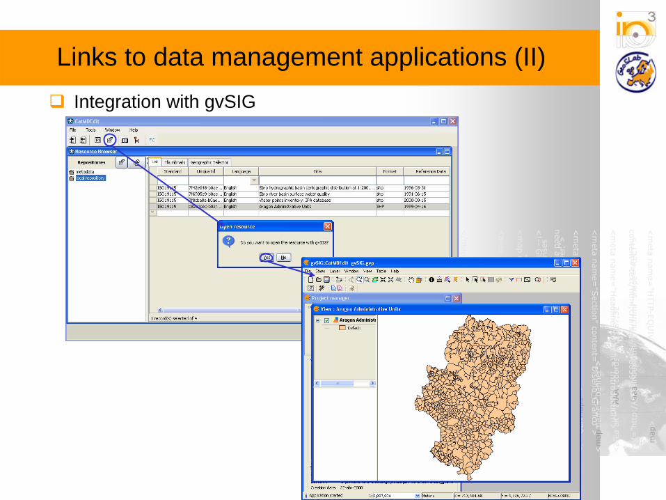
Links to data management applications (II)Integration with gvSIG

Conclusions
Well-known tool for the edition of geographic metadataAlthough it may support other metadata standards
More than 15,000 downloads through SourceForge.netUsed in reference SDI projects for metadata creation
IDEE: Spanish Spatial Data InfrastructureIDEEbro: Spatial Data Infrastructure of the Competent authority in the Ebro river basinIDEZar: Spatial Data Infrastructure of the Zaragoza City CouncilSDIGER project: first INSPIRE pilot project
Translated to 6 languages and other under development