casestudies - cooperative conservation america
TRANSCRIPT

Faces and Places of Cooperative Conservation 35
CHAPTER TWO
Southeast Region
Kentucky, Tennessee, North Carolina, South Carolina, Mississippi, Alabama, Georgia, Florida,
Puerto Rico, Virgin Islands
0 100
0 100 200 Miles
200 KilometersNorth
PUERTO RICO VIRGIN ISLANDS
MISSISSIPPI
ALABAMA
FLORIDA
NORTHCAROLINA
SOUTHCAROLINA
GEORGIA
KENTUCKY
TENNESSEE
S O U T H E A S T

COOPERATIVE CONSERVATION CASE STUDY
Agency on Bay Management
Willingness to Work Together Overcomes Obstacles
Location: Tampa Bay, Florida
Project Summary: The Agency on Bay Management (ABM) is a 20-year collaboration of resource stakeholders focused on the wise management of Tampa Bay.
Innovation/Highlight
Created a single forum for constructive dialogue to regularly address bay-wide problems and gain buy-in on solutions.
The 20-year commitment to ABM participation is a striking testament to the importance of collaborative management
to all involved parties.
Project Contact
Suzanne CooperPrincipal PlannerTampa Bay Regional Planning Council727-570-5151 x 32 [email protected]
Website: www.tbrpc.org/abm/default.htm
Resource ChallengeThroughout the late 1970s, untreated sewage discharge, rampant dredge-fi ll to create developable waterfront, and unregulated industrial activity destroyed more than 50 percent of Tampa Bay’s natural shoreline and severely degraded its aquatic habitats. The industrial, municipal, conservation, and fi sheries-dependent communities were widely polarized, with no existing mechanism to bring the disparate interests together to address resource problems.
Examples of Key PartnersThe counties and cities bordering Tampa Bay; four regional, fi ve state, and four federal agencies; three port authorities; four nonprofi t environmental, recreation, and conservation groups; eight industrial and commercial users of Tampa Bay; and three research institutions.
Results and AccomplishmentsThe Tampa Bay Regional Planning Council established the Agency on Bay Management (ABM) in 1985 as the primary organization committed to managing the Tampa Bay estuary. It provides a broad based forum for discussing the myriad issues involving the estuary and advocates for Bay restoration. Sound science and economics meet in consensus-based recommendations that are dramatically improving habitat and water quality while supporting a thriving economy. The ABM achievements include:
• Established the Piney Point Task Force to help the Florida Department of Environmental Protection (FDEP) manage an abandoned phosphogypsum operation that was contributing nutrient-laden acidic process water.
Three lined ponds and one partially lined pond are situated atop the Piney Point phosphogypsum stack ponds.
• Conceived the highly successful statewide Surface Water Improvement and Management (SWIM) program, completing 59 habitat restoration and stormwater quality projects that restored 1,600 acres of coastal habitat and signifi cantly improved the Bay’s seagrass habitat and water quality.
• Formed the Manatee Protection Strategies Task Force, generating management recommendations that were later incorporated into boating regulations and voluntary protection measures.
• Organized and produced the 1991 Proceedings of the Bay Area Scientifi c Information Symposium (BASIS 2), using information collected about the Tampa Bay Watershed, and put together the 1996 BASIS 3 proceedings, discussing research to protect, restore, and manage the bay’s estuary.
• Produced the annual State of Tampa Bay report for the public for 16 years, recently replaced by Bay Soundings, an independent quarterly publication dedicated to reporting the challenges, programs, and successes in the Tampa Bay estuary and its watershed.
FL D
EPT.
OF
ENV
IRO
NM
ENTA
L PR
OTE
CTI
ON
36 Faces and Places of Cooperative Conservation

Faces and Places of Cooperative Conservation 37
Project Contact
Daniel J. DunnCultural and Natural Resources Branch Chief Environmental Management DivisionRedstone Arsenal. U.S. Army256-876-4572 [email protected]
COOPERATIVE CONSERVATION CASE STUDY
Alabama Cave Shrimp
Partners Protect Delicate Cave Habitat
Location: Madison County, Alabama (Redstone Arsenal)
Project Summary: A diverse array of stakeholders rallies to protect a cave-dwelling endangered species smaller than a U.S. penny.
Innovation/Highlight
Redstone Arsenal’s willingness to forge alliances with Federal and State agencies to develop much needed information about
the federally-endangered Alabama cave shrimp.
Resource ChallengeThe Alabama Cave Shrimp is a tiny creature that is nearly transparent and less than an inch long. It lives in fl ooded underground caverns and pools in caves, where it eats small bits of organic matter. The cave shrimp is found in just two cave systems in Madison County, Alabama, one of which is within the boundaries of the U.S. Army’s Redstone Arsenal. It was Federally-listed as an endangered species in 1988. The main threats to its survival are a low reproduction rate and groundwater contamination.
The Redstone Arsenal’s environmental offi ce has worked closely with other Federal, state and local authorities, scientists, local educators, homeowners, and the surrounding community to protect Alabama cave shrimp populations on the Army installation and on private lands, as well as potential habitat for populations that might yet be discovered.
Relatively little is known about the shrimp’s biology and habitat needs, making it diffi cult to prepare a survival and recovery plan. To fi ll the information gap, the U.S. Department of Defense, USDI Fish and Wildlife Service (FWS), the State of Alabama, local governments, academia, and the scientifi c/professional community have surveyed several hundred potential cave habitats and are monitoring cave shrimp populations and water quality on Redstone.
Examples of Key PartnersLocal landowners, U.S. Army Redstone Arsenal, FWS, City of Madison, Alabama; Redstone Arsenal Environmental Offi ce, City of Huntsville, Alabama; Geological Survey of Alabama, National Speleological Society, and the University of Alabama.
The tiny Alabama cave shrimp is smaller than a U.S. penny.
Results and Accomplishments
• Protecting Alabama cave shrimp habitat on and off the installation.
• Discovered the second known population of Alabama cave shrimp in Herring, Braselton, and Glover caves (considered one cave system) in 1993.
• Completed hydrologic modeling for Bobcat Cave and the Herring, Braselton, and Glover Caves systems to determine where groundwater in the caves originates.
• Assisted in the formation of the Flint River Conservation Association, which has been very active in protecting water quality in the Flint River Watershed where the Herring-Glover-Brazelton cave system is located.
• Assisted in the formation of the Keel Mountain Homeowners Association, which is actively protecting water quality in the groundwater recharge area for Herring, Braselton, and Glover caves.
• Helped found the annual Madison County Drinking Water Festival. Thousands of Madison County fourth graders gather at the University of Alabama in Huntsville to learn about protecting area groundwater from pollution.
PHO
TO B
Y D
AV
E D
IETE
R

COOPERATIVE CONSERVATION CASE STUDY
Arnold Air Force Base (AFB) Conservation Core Team
Using Partnerships and New Technology to Monitor and Manage Sensitive Ecosystems
Location: Central Tennessee
Project Summary: A Conservation Core Team initiated by Arnold AFB is helping restore and protect listed species and important habitat on Tennessee’s southeastern Highland Rim.
Innovation/Highlight
The Air Force’s fi rst successful restoration of a threatened species: Eggert’s sunfl ower.
Project Contact
Sally Rollins PalmerScience Program Coordinator The Nature [email protected]
Resource ChallengeArnold AFB falls within Tennessee’s southeastern Highland Rim physiographic province. The vicinity around the Base is noted for its Barrens, which feature heavy clay soil and wetland vegetation. Its rich diversity of species includes some 77 rare species, including the Gray Bat, a federally listed endangered species.
Managing sensitive, diverse ecosystems presents unique challenges. In 1995, the Base initiated a partnership called the Conservation Core Team in response to a US Department of Defense (DOD) ecosystem-based management policy set the year before. Members of the Team include scientists and natural resource experts from academia, non-profi t organizations, and state and federal agencies.
Examples of Key Partners The Nature Conservancy, The University of the South, Arnold AFB, USDI Fish and Wildlife Service (FWS), U.S. Geological Survey, Middle Tennessee State University, Tennessee Army National Guard, Tennessee Natural Areas Program, Tennessee Wildlife Resources Agency, University of Tennessee.
Results and AccomplishmentsAmong the project’s many outcomes, the most notable may be the recovery of the threatened Eggert’s sunfl ower. The plant is now fl ourishing, experiencing a 33 percent increase in population since 1995. As a result, the FWS delisted the species from threatened status. Genetic research that established criteria for functioning
Restoration burn in wetlands at Goose Pond National Natural Landmark, Arnold Air Force Base.
sunfl ower populations, and successful habitat restoration, are two of the factors responsible for its delisting. Crucial to the positive outcome was a Cooperative Management Agreement between Arnold AFB, other Core Team partners, and the FWS that made the project possible.
The Base has implemented a variety of management activities, including prescribed fi re, forest thinning, managing invasive plants, restoring natural hydrology, and controlling unauthorized human activities. Examples include:
• Used remote sensing for surveys and inventories, enhancing fi eld work and saving 30 to 40 percent of the cost of traditional approaches.
• Located and identifi ed bat sounds using modern technology to determine whether endangered species existed on the property, without having to stop military training exercises.
• Assessing and monitoring conditions to determine the status of ecological communities and trends.
• Restored 2,000 acres of Barrens habitat.• Managed 1,894 acres of Karst wetlands including restoration of
natural hydrology affecting 200 acres of wetlands.• Participated in regional initiatives to increase Gray Bat
populations.
PHO
TO B
Y J
OH
N L
AM
B
38 Faces and Places of Cooperative Conservation

Faces and Places of Cooperative Conservation 39
COOPERATIVE CONSERVATION CASE STUDY
Atlantic Station Redevelopment
Using Smart Growth Strategies to Lower Emissions
Location: Atlanta, GA
Project Summary: Innovative Smart Growth practices alleviate air pollution and foster development that combats sprawl and supports economic development.
Innovation/Highlight
By identifying and using smart growth development strategies in the City, partners were able to minimize
pollution and produce air quality benefi ts, overcoming regulatory barriers to infrastructure changes.
Project Contact
Brian LearyVice President, Design & Development Atlantic Station, L.L.C. 404-876-2616 [email protected]
Website: www.atlanticstation.com
Resource ChallengeAtlantic Station occupies land formerly used by Atlantic Steel Industries, Inc., the fi rst steel mill in Georgia. During its prime, Atlantic Steel was Georgia’s largest employer, but by 1998 the mill maintained only skeletal operations. What remained was largely an abandoned 138-acre brownfi eld in the heart of the rapidly growing City of Atlanta.
Jacoby Development, Inc., in a joint venture with AIG Global Real Estate Investment Corp., worked closely with federal, state, and public interests to clean up and convert the property into Atlantic Station, a $2 billion redevelopment project. Challenges included removing contaminated soils, separating sanitary and storm sewer systems, reducing auto emissions, and creating jobs and economic vitality around existing infrastructure.
Examples of Key PartnersAtlantic Steel Industries, Inc., Jacoby Development, Inc., State of Georgia, City of Atlanta, U.S. Environmental Protection Agency (EPA), Federal Highway Administration, Federal Transit Administration, Metropolitan Atlanta Rapid Transit Authority, Atlanta Regional Commission, Midtown Alliance (local business interests), neighborhood organizations, and others.
Results and AccomplishmentsBecause Atlanta was not in compliance with Clear Air Act standards at the time, development of the brownfi eld site came to a halt. A standard interpretation of the regulations would have prohibited the building of new roads, which made it impossible to construct a bridge to reconnect the isolated brownfi eld site to Midtown Atlanta, as well
Old steel presses have been preserved as outdoor sculptures in the Commons Park overlooking the lake and new townhouses.
as to nearby public transit and the adjacent interstate highway. This obstacle was removed after an EPA analysis showed that the smart growth aspects of the redevelopment—encouraging development in the City and providing better access to mass transit—would reduce vehicle miles traveled and total air pollution.
Collaborative problem-solving and innovative thinking have revived the area, with new residents and businesses coming into the city instead of fl eeing to the suburbs.
Other accomplishments include:
• Created 5,000 homes, from single family dwellings to loft apartments and condominiums.
• Created employment opportunities for 30,000 people.• Stimulated development that will eventually include 12 million
square feet of retail, offi ce, residential, and hotel space, and 11 acres of public parks.
• Developed an incentive program that includes access to electric vehicles and discounted rates for using mass transit.
The fi rst residential structures were leased in 2003. The fi rst commercial, retail, and entertainment establishments opened in 2004; additional retail locations will open in late 2005. The project was awarded the national 2004 Phoenix Award for excellence in brownfi eld redevelopment.

COOPERATIVE CONSERVATION CASE STUDY
Bartow County Environmental Management System
Using Partnerships and EMS to Cut Pollution
Location: Bartow County, Georgia
Project Summary: Local partnerships are developing and implementing multiple Environmental Management Systems in a coordinated county-wide fashion to signifi cantly reduce pollution.
Innovation/Highlight
This partnership has implemented multiple Environmental Management Systems in a coordinated county-wide fashion to
signifi cantly reduce pollution across the entire county.
Project Contact
Gene CampWater [email protected] Website: www.bartowga.org
Resource ChallengeBartow County, located approximately 40 miles northwest of Atlanta, is one of the fastest growing counties in Georgia, with six cities, two school systems, and approximately 84,000 residents. County leaders became concerned about preserving the county’s air quality in the face of rapid growth from nearby Atlanta. After learning about Environmental Management Systems (EMS) in the summer of 2003, Sole County Commissioner Clarence Brown committed the county to developing the “fi rst in the nation county-wide EMS” to help manage not only potential air pollution sources, but problems involving land and water resources, solid and hazardous wastes.
Commissioner Brown started a county-wide partnership including the six cities, two school districts, Cartersville–Bartow County Chamber of Commerce, and the County’s agricultural community to develop and implement Environmental Management Systems in a coordinated county-wide fashion. EMS goals include improving the county’s quality of life and business climate by reducing air emissions, minimizing the production of solid and hazardous waste, and improving the management of waste and water resources. Phase I goals were specifi cally focused on improving air quality with a target 10 to 25 percent air emission reduction. Already, the 25 percent reduction has been attained.
Examples of Key PartnersBartow County Governments, Cartersville-Bartow County Chamber of Commerce, Shaw Industries Inc., Anheuser-Busch, Georgia Power Company-Plant Bowen, Cartersville Medical Center, Agra-Business
Plant Bowen and the Bartow County agricultural community joined in developing EMSs.
community, University of Georgia, Georgia Tech Institute of Technology (GT) Peer Center, United States Environmental Protection Agency (EPA), and others.
Results and AccomplishmentsAs many as 10 to 20 EMS projects are in progress, including: Georgia Power Plant Bowen; Shaw Industries, Inc.; Anheuser-Busch; County and City School Systems, Public Works, Water and Wastewater Departments; and the County Sheriff ’s Department. The County and the Chamber of Commerce are working together to coordinate individual EMS projects and have developed a number of tools to assist: • Adopted Bartow County & Cartersville Bartow County Chamber
of Commerce EMS Vision and Mission Policy Statements.• Developed Website, registration and performance forms for EMS
Project for reporting and data management; developed Contact Data Information Base; developed Data Base of Required EMSs for Government Departments/Agencies; and developed a Quarterly Project Tracking Form for EMS Performance Results.
• Preparing a Website database to maintain information on air reductions, waste minimization, recycling, water quality improvements, etc.; and to educate the public.
• Developed an Air Quality Tool Box for Local Offi cials. • Reduced air emissions by 25 percent.• Conducted county-wide Baseline Audit for all media (Air, Land,
and Water).
PHO
TO C
OU
RTES
Y O
F G
EORG
IA P
OW
ER
40 Faces and Places of Cooperative Conservation

Faces and Places of Cooperative Conservation 41
Project Contact
Mollie Glover PalmerDeputy Chief of StaffOffi ce of the SecretaryFlorida Department of Environmental [email protected] .us
Website: http://aec.army.mil/usaec/natural/natural03a.html
COOPERATIVE CONSERVATION CASE STUDY
Compatible Use Buffer Program
Resolving Encroachment Issues Using Natural Resource Buffers
Location: Camp Blanding, Florida
Project Summary: Florida agencies and groups worked with Camp Blanding to create buffer zones to stem base encroachment and to provide open space for conservation.
Innovation/Highlight
The fi rst buffers program implemented under the Army’s Compatible Use Buffer Program.
Resource ChallengeCamp Blanding Joint Training Center, primary training facility of the Florida Army National Guard (FLARNG), is located about halfway between the fast-growing communities of Jacksonville and Gainesville. Once in a remote location, urbanization and other outside infl uences have brought increasing encroachment pressure, requiring new approaches to balancing community growth and the integrity of military training operations.
Recognizing that the effectiveness of the Florida Army National Guard’s 73,000-acre training center depends, in part, on how well it addresses encroachment and range sustainability issues, Camp Blanding’s Post Commander, his conservation staff, and the Florida National Guard pursued a partnership with state and local governments and non-government organizations to establish natural resource buffers surrounding the installation. The goal was to achieve military objectives while helping the State and other organizations achieve their own natural resource conservation and land management objectives.
Examples of Key PartnersFederal Agencies: Florida Army National Guard (FLARNG), Camp Blanding Environmental Division, U.S. Army Environmental Center, National Guard Bureau; State Agencies: Florida Department of Environmental Protection (FDEP), Offi ce of Greenways and Trails Acquisition and Restoration Council, Suwannee River Water Mgmt. District, Bradford and Clay Counties, Cities of Middleburg, Orange Park, and Penny Farms; St Johns River Water Mgmt. District, Florida Defense Alliance; The Nature Conservancy; landowners and developers.
A group receives tour of Blanding’s natural resources.
Results and AccomplishmentsState of Florida participants conceived of the buffer idea, since it would help the State conserve open space as well as help the military post with its encroachment problems. Non-federal participants planned the program, identifi ed willing sellers, negotiated purchases, and closed deals, contributing $12,500,000 to date. Camp Blanding participated in the process and requested $500,000 through the National Guard Bureau.
The buffers program at Camp Blanding was the fi rst to be implemented under the Army’s Compatible Use Buffer Program to ensure sustainability of the military training mission into the foreseeable future. In addition to the advantages buffers provide to military training, the project contributed to the Florida Forever conservation initiative. Camp Blanding and the surrounding newly-protected lands will now be part of approximately 110 miles of greenway extending from Osceola National Forest to the Ocala National Forest. The new buffer zone should benefi t all 60 rare and endangered species in the region.
PHO
TO B
Y J
AC
LYN
WIC
KER
T
COOPERATIVE CONSERVATION CASE STUDY
Energy Grants to Agricultural Producers
Enhancing Energy Effi ciency in Poultry Operations
Location: South and Central Mississippi
Project Summary: A partnership was formed to assist agricultural producers in enhancing the economic viability of their poultry production facilities by improving energy effi ciency.
Innovation/Highlight
Cooperation among federal and state agencies, along with organizations representing agricultural producers, brought
fi nancial and technical assistance to Mississippi’s poultry producers, helping them improve their energy effi ciency
and increase profi ts.
Project Contact
Leslie Threadgill Grower Relations CoordinatorMississippi Poultry [email protected]
Resource ChallengeEnergy effi ciency is critical to poultry producers, especially for those who have dated production houses, which usually lack more effi cient design and construction features of newer production houses. Given the competitive markets in today’s poultry industry, producers need to reduce their energy usage and increase their production to remain competitive. Energy costs consume about 20 percent of a broiler producer’s total return. Meanwhile, energy costs continue to climb while the prices paid to producers have remained relatively stable. Section 9006 of the Farm Security and Rural Investment Act of 2002 (Farm Bill) launched the Renewable Energy and Energy Effi ciency Improvements Grants Program, designed to assist agricultural producers and small rural businesses with installing renewable energy systems and making their facilities more energy effi cient. Producers lacked the resources to prepare grants and most were unaware of the Section 9006 grant program. The Southwest Mississippi Resource Conservation and Development Council saw an opportunity to assist some of the state’s nearly 3,000 poultry producers in making their agricultural operations more energy effi cient.
Examples of Key PartnersSouthwest MS RC&D Council, Mississippi Poultry Association, MS State University-Extension Service-Food & Fiber Center (CSREES), MS State University-Poultry Science Department, Mississippi Development Authority, USDA Rural Development-Rural Business/Cooperative Service, USDA Natural Resources Conservation Service (NRCS), and Mississippi Farm Bureau.
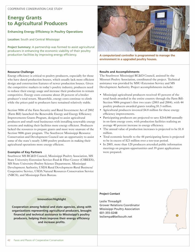
A computerized controller is programmed to manage the environment in a upgraded poultry houses.
Results and AccomplishmentsThe Southwest Mississippi RC&D Council, assisted by the Missouri Poultry Association, coordinated the project. Technical assistance was provided by MSU-Extension Service and MS Development Authority. Project accomplishments include:
• Mississippi agricultural producers received 45 percent of the total funds awarded in the entire country through the Farm Bill-Section 9006 program’s fi rst two years (2003 and 2004), with 44 poultry producers awarded grants totaling $1.5 million.
• Agricultural producers invested $4.8 million for these energy effi ciency improvements.
• Participating producers are projected to save $264,000 annually in on-farm energy costs, with production facilities realizing an average 40 percent increase in energy effi ciency.
• The annual value of production increases is projected to be $1.8 million.
• Total economic benefi t to the 44 participating farms is projected to be in excess of $23 million over a ten-year period.
• In 2005, more than 120 producers attended public information meetings on program opportunities and 39 grant applications were prepared.
42 Faces and Places of Cooperative Conservation

Faces and Places of Cooperative Conservation 43
COOPERATIVE CONSERVATION CASE STUDY
Gopher Tortoise Conservation Bank
Tortoises Winning the Race Against Extinction
Location: Mobile County, Alabama
Project Summary: A conservation bank is helping to restore the gopher tortoise, protect black pine snakes, and ensure affordable house lots in Mobile County, Alabama.
Innovation/Highlight
Conservation “banks,” funded by landowners and developers, create large blocks of high quality habitat and provide
funds for listed species management.
Project Contact
Robert Bonnie, Managing DirectorCenter for Conservation IncentivesEnvironmental [email protected]
Website:www.mawss.com/gopher.htm andwww.environmentaldefense.org/article.cfm?contentid=2665
Resource ChallengeNearly 20 percent of Mobile County, Alabama’s population lives below the poverty level. Low incomes have created a demand for small, affordable house lots, fragmenting the longleaf pine habitat essential to the threatened gopher tortoise. Much of the undeveloped habitat is in poor condition because of inadequate management.
Afraid it would run afoul of the Endangered Species Act, Mobile County stopped issuing building permits in 1999 for areas with tortoise populations. Besides being controversial among landowners and developers, it quickly became apparent that a moratorium by itself would not improve gopher tortoise survival.
The Mobile Area Water and Sewage System (MAWSS) proposed that the County establish a “conservation bank” on properties around its reservoir. The “bank” is a large piece of property that can be managed more effectively than a smaller number of unconnected tracts. Landowners and developers who had tortoise habitat on their property could purchase credits to fund management at the “bank” and to continue building. The MAWSS could also use credits to add more land to the bank, expanding its quality habitat that more than makes up for land lost to development.
In 2001, about 220 acres of longleaf pine habitat became the gopher tortoise conservation bank. Today, more than 55 bank credits have been sold for $3,500 per credit. As the bank’s owner, MAWSS fi nances tortoise conservation on its lands while helping to avoid a costly endangered species controversy.
The gopher tortoise is a keystone species of the longleaf pine ecosystem–over 360 other species use tortoise burrows.
Environmental Defense assisted in designing the conservation bank and drafting its habitat conservation plan. The USDI Fish and Wildlife Service (FWS) works with MAWSS to manage the bank and monitor the tortoise population. The University of South Alabama also monitors the bank, while a science advisory board assists with the bank’s operation.
Examples of Key PartnersFWS, MAWSS, Environmental Defense, University of South Alabama, Advisory Board of scientists.
Results and Accomplishments Since the bank began, the number of resident tortoises has grown from 12 to more than 60, the result of natural reproduction and relocations from development sites. The bank is also providing habitat to black pine snakes, a candidate species for listing. Indeed, the bank has been so successful that MAWSS may expand it to additional lands.
The bank has been equally successful for developers and home buyers. The moratorium on building permits was lifted, allowing construction of affordable housing to continue.

COOPERATIVE CONSERVATION CASE STUDY
Greater Everglades Ecosystem Restoration
Restoring the Everglades Forevermore
Location: Southern Florida
Project Summary: The Greater Everglades Ecosystem Restoration initiative puts in place the largest and most ambitious watershed recovery program in U.S. history.
Innovation/Highlight
A massive wetland restoration project built on unprecedented federal, state and inter-agency cooperation and partnerships.
Project Contact
Martha N. Garcia U.S. Geological [email protected]
Websites: www.sofi a.usgs.govwww.sfrestore.org
Resource ChallengeThe Florida Everglades is a complex ecosystem. Once spanning four million acres, the Everglades have shrunk to half that amount. Ecosystem decline began with draining wetlands for irrigation channels. Hurricane-related fl ooding in the 1920s accelerated drainage projects, culminating in the Congressionally-authorized Central and Southern Florida (C&SF) Flood Control Project in 1948, which further fragmented the Everglades.
During the past two decades, the Florida Legislature and Congress have enacted several laws and programs aimed at restoring the Greater Everglades ecosystem. In 2000, the U.S. Congress authorized the Comprehensive Everglades Restoration Plan (CERP), expected to be implemented over the next four decades.
Examples of Key Partners U.S. Army Corps of Engineers, USDI Fish and Wildlife Service, USDI National Park Service, USDI Bureau of Indian Affairs, Florida Department of Environmental Protection, Florida Geological Survey, Florida Institute of Oceanography, Florida Bay and Adjacent Marine Systems Program, National Oceanic and Atmospheric Administration, National Marine Sanctuary, USDA Natural Resource Conservation Service, Florida Offi ce of the Governor, South Florida Water Management District, U.S. Environmental Protection Agency, and others.
Results and AccomplishmentsThe USDI is collaborating with the State of Florida, the South Florida Water Management District, and the U.S. Army Corps of
Field studies conducted in the Everglades support ecosystem management and restoration.
Engineers to implement the world’s largest watershed restoration project, the Comprehensive Everglades Restoration Plan. Designed to restore, conserve, and protect the South Florida ecosystem, Plan-inspired initiatives have reduced pollution fl owing into the Everglades by almost 50 percent during the past several years. Water fl ows are beginning to be restored to the ecosystem, while habitat improvements are helping the recovery of endangered species.
The USDI leads the Everglades Ecosystem Restoration Task Force, consisting of state, federal and local stakeholders, and tribes. The Task Force oversees the complex engineering, legal, and environmental issues facing Everglades restoration. Accomplishments to date include:
• An agreement was made to ensure that water captured under the Everglades restoration program can be used for restoring the Everglades.
• Regulations were adopted to guide the implementation of the Everglades restoration plan.
• Key parcels of land were acquired for restoration. • Conservation and habitat recovery projects were established for
endangered species. • $74 million was secured in FY 2004 for restoration of water fl ows
and protection of wildlife habitat.
As a result of the concentrated attention to Everglades restoration, the State of Florida has announced its “Acceler8” Initiative to speed-up restoration of the Everglades and signifi cantly increase water supplies.
44 Faces and Places of Cooperative Conservation

Faces and Places of Cooperative Conservation 45
COOPERATIVE CONSERVATION CASE STUDY
Gulf Coastal Plain Ecosystem Partnership
Buffering Military Facilities and Supporting Conservation
Location: Florida Panhandle and South Alabama
Project Summary: The Gulf Coastal Plan Ecosystem Partnership is a landscape-scale effort to link base encroachment mitigation with regional conservation/green space goals.
Innovation/Highlight
A partnership formed to increase buffers around military reservations but contributing to green space conservation
on a landscape-scale.
Project Contact
Mr. Vernon ComptonProject DirectorGulf Coastal Plains Ecosystem [email protected]
Resource ChallengeFlorida’s Western Panhandle is one of the most rapidly growing areas in the Nation; its pristine coastal region is under intense development pressure. Rapid growth and the loss of green space are creating serious encroachment issues for Eglin Air Force Base (AFB), Pensacola Naval Air Station (NAS), and NAS Whiting Field. The most serious issues include concerns about low level fl ights and weapons testing in the face of encroaching development.
From a conservation perspective, the area includes the largest remaining stands of natural longleaf pine forests and some of the last undeveloped coastline on the Gulf. The pine forests shelter rare and listed species, including the world’s 4th largest population of the endangered Red-Cockaded Woodpecker. Conservation organizations have concerns about timber production and sustainable forestry, outdoor recreation, conserving biodiversity, wildlife management, and protecting water resources.
The Gulf Coastal Plain Ecosystem Partnership (GCPEP), formed in 1996 via a Memorandum of Understanding, launched a joint planning process to identify conservation goals and actions, and to provide buffers for military lands. Non-government partners have contributed funds and offi ce space, and have provided volunteers, public outreach, and other services.
Examples of Key PartnersInternational Paper Company, Nokuse Plantation, The Nature Conservancy, Florida Division of Forestry: Blackwater, Point Washington, and Pine Log State Forests, Florida Department of
Watershed restoration is one of the many activities where collective expertise is shared among partners.
Environmental Protection, Florida Fish and Wildlife Conservation Commission, Northwest Florida Water Management District, USDA Forest Service, Conecuh National Forest, US Department of Defense: Eglin AFB, NAS Pensacola, and NAS Whiting Field; and the USDI National Park Service Gulf Islands National Seashore.
Results and AccomplishmentsThe Gulf Coastal Plain Ecosystem Partnership recently expanded, and now covers more than one million acres. It is working to increase buffers around military reservations, improve biodiversity management, and assure green space and recreation opportunities for the region. Its activities include:
• Participating in the “Florida Greenways Project,” a multi-agency/organization initiative that is working to create a greenway from the Gulf of Mexico south of Tallahassee through Eglin AFB, NAS Pensacola, and NAS Whiting Field to Ocala National Forest further south.
• Completed land deals that have protected tens of thousands of acres immediately adjacent to the three DoD installations.
• Supported scientifi c workshops to develop a regional strategic conservation plan.
• Created an Ecosystem Support Team for on-the-ground management. The team conducts ecological monitoring of key natural communities, has assisted with more than 39,000 acres of prescribed burning on GCPEP lands, and helped the partners with Hurricane Ivan relief.
PHO
TO B
Y P
AU
L O
TTO

COOPERATIVE CONSERVATION CASE STUDY
Gulf of Mexico Integrated Science in Tampa Bay
Bringing Multiple Disciplines Together
Location: Tampa Bay, Florida
Project Summary: Scientists collaborate across disciplines to acquire scientifi c data on Tampa Bay that will help managers conserve and protect its resources.
Innovation/Highlight
Integrated science from several disciplines to understand the estuary as a whole.
Project Contact
Holly GreeningSenior ScientistTampa Bay Estuary Program727-893-2765 [email protected]
Website: www.gulfsci.usgs.gov
Resource ChallengeThe Tampa Bay estuary faces major challenges: exploding population growth, demands for water, expansion at three major shipping ports, dredging, construction of a desalination plant and gas pipeline, and ships that transport 55 billion gallons of hazardous material each year.
The Tampa Bay Estuary Program (TBEP) was created in 1991 to help local science and resource management agencies cooperatively implement a Comprehensive Conservation and Management Plan for Tampa Bay. Partners asked the U.S. Geological Survey (USGS) to lead an effort to identify scientifi c information needed to understand the Bay and to improve resource management. The result was the Tampa Bay Study, a cross-discipline effort that could only be accomplished through partnerships.
Examples of Key PartnersGulf of Mexico Program, Southwest Florida Water Management District, Florida Department of Environmental Protection, Counties of Pinellas, Hillsborough, Hernando, Pasco, and Polk; Tampa Bay Water, U.S. Army Corps of Engineers, NASA, National Oceanic and Atmospheric Administration (NOAA), U.S. Environmental Protection Agency, City of Tampa, University of the South, Eckerd College, University of Louisiana, Wayne State University, Lewis Environmental Services, Inc., non-governmental organizations and others.
Results and AccomplishmentsThe Tampa Bay Estuary Program coordinates work needed to meet the objectives of the Comprehensive Conservation and Management Plan. The USGS is a TBEP member and coordinates organizations
Two U.S. Geological scientists sampling in Tampa Bay for juvenile fi sh of commercial and recreational importance.
and participants working on the Tampa Bay Study. To complete the study, multidisciplinary teams of scientists work across and beyond their scientifi c fi elds. The study has led to new partnerships with private sector and local interests, and with universities outside of Florida. Partnerships have grown stronger as they discover ways to integrate their research.
Project scientists from the key organizations doing the study have provided data critical to understanding how past activities have affected the Bay, and critical to predicting future impacts of urbanization on wetlands, aquatic habitats, and water quality. Examples of their work include:
• Collected essential wetland data to improve wetland restoration decision-making in Tampa Bay Preserves.
• Quantifi ed groundwater fl ow to the Bay, using the data to modify the Tampa Bay water budget used by water resource managers.
• Used expertise and data sets from different agencies and the private sector to create web-accessible tools that help synthesize science information.
• Worked collaboratively to provide training to hundreds of scientists, resource managers, and to K- 12 and higher education teachers on how to use web-accessible tools.
• Worked cooperatively to develop a numerical integrated coastal model to predict bay-wide impacts of environmental disturbances.
46 Faces and Places of Cooperative Conservation

Faces and Places of Cooperative Conservation 47
COOPERATIVE CONSERVATION CASE STUDY
Jupiter Inlet Natural Area
Where History, Coast Guard Operations and Nature Meet
Location: Jupiter Inlet, Florida
Project Summary: The Bureau of Land Management (BLM) works with federal, county, municipal, educational and non-profi t groups to manage a key regional landmark in northern Palm Beach County.
Innovation/Highlight
Strong community involvement makes it possible to effectively manage an historic site, active Coast Guard facility, and sensitive
habitats on a 128-acre natural area.
Project Contact
Richard WaleskyDirectorPalm Beach County Environmental Resources [email protected] .us
Resource ChallengeJupiter Inlet Natural Area, located in Palm Beach County, Florida, is a prime attraction for two cities and thousands of visitors. Rich in history, it has been used for a lighthouse and by the military since the 1850’s. Jupiter Lighthouse is listed on the National Register of Historic Places. Today, the site includes a still-active U.S. Coast Guard facility. Jupiter Inlet is also rich in natural resources, an oasis in an increasingly-urban environment. On the County’s list of Environmentally Sensitive Lands, it supports 17 special status species, including four Federally-listed species.
After the Coast Guard declared some of the property surplus, the Jupiter Inlet partnership formed to restore the Natural Area. Partners decided to take a collaborative approach to restoration because of intermingled administrative boundaries and their varying missions.
Examples of Key PartnersUSDI Bureau of Land Management (BLM), Palm Beach County, U.S. Coast Guard, Town of Jupiter, Village of Tequesta, Loxahatchee River Historical Society, Jupiter High School Environmental Research and Field Studies Academy.
Results and AccomplishmentsPartnership activities:
• Restored the lighthouse on U.S. Coast Guard-administered land, using $855,000 acquired by the Loxahatchee River Historical Society and administered by the town. The town invested another $750,000 to renovate Jupiter Lighthouse Park.
Students testing a net that they designed to monitor fi sh entering the new lagoon built by the Bureau of Land Management.
• Constructed an award-winning wetland, removing thousands of invasive trees; partners conduct annual sweeps to suppress regrowth of invasive plants.
• Matched every BLM dollar spent at the Jupiter Inlet Natural Area with local funds.
• Completed two prescribed burns to reduce fuel loads and improve wildlife habitat. Seven organizations contributed funding, expertise, and equipment.
• Established an outdoor classroom and volunteer program in cooperation with Jupiter High School. Students monitor burn plots, sample fi sh, and supply labor for events. Volunteers have donated more than 3,000 hours during the last ten years.
• Responding quickly after last year’s hurricanes, volunteers cleared debris and collected cones to reestablish decimated sand pine forests.
As testament to the dedication and support of local communities, the USDI presented the town with a patent for Jupiter Lighthouse Park in 2004. The Partnership has received several awards: the BLM Legacy of the Land and the BLM Four C’s award; in 2004, Juniper High School received a Take Pride in America award for its volunteerism. The site has been selected for the Hands on the Land program, a web-based network of outdoor classrooms across the country.

Project Contact
Mr. Wade C. HarrisonChattahoochee Fall LineProject Director The Nature ConservancyFort Benning Offi [email protected]
COOPERATIVE CONSERVATION CASE STUDY
Longleaf Pine and Red-Cockaded Woodpecker Recovery
Restoring Longleaf Pine Habitats without Harming Inhabitants
Location: Fort Benning, Georgia
Project Summary: Partners at Fort Benning are working to expand longleaf pine stands to all upland pine sites and increase red-cockaded woodpecker breeding groups to 350.
Innovation/Highlight
Converting a major forest type while recovering an endangered species that is 70 percent dependent on the tree
species being converted.
Resource ChallengeFort Benning’s pine forests are primarily loblolly and shortleaf pine that seeded naturally on abandoned farmland soon after the Army acquired the lands in the 1920s and the early 1940s. These tenacious forests have persisted despite generations of intensive row-crop agriculture, heavy military training, lack of natural fi res, and repeated timber harvesting.
Fort Benning’s forests are now critical to supporting one of the 15 designated red-cockaded woodpecker (RCW) recovery populations. However, the forests are unhealthy and dying prematurely from pine forest decline syndrome, which is proceeding at a rate faster than new growth.
In 1990, Fort Benning had about 6,000 acres of longleaf pine. At that time, biologists identifi ed 172 active RCW clusters on 100,000 acres of managed upland pine forests. Fort Benning reached out to experts to help with forest restoration. The challenge is to restore the longleaf pine forests which once dominated Fort Benning uplands, and at the same time, maintain existing old growth loblolly and shortleaf pine RCW habitat. Achieving those goals will conserve the federally endangered red-cockaded woodpecker (RCW) by creating and maintaining the large, open, natural longleaf pine forests they need.
A longleaf pine stand on Fort Benning displays the desired condition for recovery of the red-cockaded woodpecker.
Examples of Key PartnersFederal Agencies: USDI Fish and Wildlife Service, USDA Forest Service, and U.S. Army Fort Benning; Non-government: The Nature Conservancy, NatureServe, Jones Ecological Research Center, and Longleaf Alliance; Academic Institutions: Clemson University, University of Georgia, Auburn University, and Louisiana State University.
Results and AccomplishmentsThe partners fi rst concentrated on identifying the cause of the die-off and how best to slow it down. Next, they evaluated techniques to convert existing forests to longleaf pine using timber harvests and prescribed burning. Finally, they acquired knowledge and skills needed to artifi cially reforest areas with nursery grown seedlings. Foresters evaluated reforestation methods under existing pine canopies, projecting RCW habitat defi ciencies and prioritizing longleaf pine restoration activities.
Today, there are 34,000 acres of healthy longleaf pine and the number of RCW potential breeding groups has increased to 249. The partners are well on their way toward restoring longleaf pine on all upland pine sites while continuing to move the RCW population toward the goal of 350 potential breeding groups.
PHO
TO B
Y S
TEPH
EN H
UD
SON
48 Faces and Places of Cooperative Conservation

Faces and Places of Cooperative Conservation 49
COOPERATIVE CONSERVATION CASE STUDY
North Carolina Sandhills Conservation Partnership
Restoring the Natural Longleaf Pine-Wiregrass Ecosystem
Location: Coastal North Carolina: six-county area in and around Fort Bragg
Project Summary: The Partnership is a cooperative effort to restore Red-Cockaded Woodpecker populations on military, state, and private lands in the North Carolina Sandhills.
Innovation/Highlight
One of the fi rst partnerships between U.S. Department of Defense (DoD), non-governmental organizations (NGO), and
state and local government partners to focus specifi cally on military land.
Project Contact
Mr. Rick StudenmundSandhills Project Director The Nature [email protected]
Resource ChallengeThe Sandhills lie in the southwestern corner of North Carolina’s inner coastal plain. A region of rolling, sandy hills, it is one of the last places in the southeast where longleaf pine still dominates the landscape. Nationwide, just three percent of what was once longleaf pine ecosystem remains.
Longleaf pine provides key habitat for a variety of species that are endangered, threatened, or of concern; best known is the federally-endangered Red-Cockaded Woodpecker. Fort Bragg Military Installation has the greatest concentration of the birds in the Sandhills region and is considered the core of the Sandhills recovery population.
In 2000, the Army, USDI Fish and Wildlife Service (FWS), state agencies, and private conservation groups formed the North Carolina Sandhills Conservation Partnership (NCSCP). They share resources to:
• Coordinate public and private land protection and management programs in the Sandhills to benefi t the longleaf pine ecosystem, emphasizing Red-Cockaded Woodpecker recovery.
• Identify resource and land use priorities.• Develop resource protection and management strategies to meet
conservation goals.• Address the growing frequency of incompatible land uses on
private lands adjacent to public land.• Support military readiness at Fort Bragg.
Monitoring Red-cockaded Woodpeckers: Data taken includes group size/composition, number of eggs/nestlings and fl edgling success.
Examples of Key PartnersU.S. Army Fort Bragg, U.S. Army Environmental Center, Aberdeen, MD, USDI Fish and Wildlife Service, North Carolina Wildlife Resources Commission and North Carolina Division of Parks and Recreation, The Nature Conservancy, Sandhills Area Land Trust, and Sandhills Ecological Institute.
Results and AccomplishmentsTo date, the Partnership has:
• Conserved 9,045 acres of land either through fee simple purchase or long-term conservation easements.
• Added nineteen Red-Cockaded Woodpecker groups to the Sandhills primary recovery population.
• Used permanent conservation interests and new agreements with state partners to voluntarily manage their lands at federal recovery standards.
• Created a regional database for biologists who are cataloguing elements unique to this environment.
• Implemented the Federal Safe Harbors Program, making voluntary agreements with landowners that encourage them to manage for Red-Cockaded Woodpecker. In exchange, landowners are assured that they will not be subject to further regulation if they are successful in restoring the species.
PHO
TO B
Y E
LIZA
BETH
J. E
VAN
S
COOPERATIVE CONSERVATION CASE STUDY
Northwest Florida Greenway Project
Non-traditional Partners Work Together to Connect Protected Areas
Location: Florida Panhandle
Project Summary: Military, government and nonprofi t organizations partner to protect the Panhandle’s unique natural resources, economy, and military fl yways.
Innovation/Highlight
Varied needs of non-traditional partners were met by working for a common goal, creating a greenway to connect two tracts of
protected land, each more than one million acres in size.
Project Contacts
Ms. Mollie PalmerDeputy Chief of Staff Florida Department ofEnvironmental [email protected] .us
Ms. Debbie KellerNorthwest Florida Greenway Project Coordinator The Nature Conservancy, Florida [email protected]
Website: www.nature.org\fl orida
Resource Challenge The Nature Conservancy named the rich landscape of northwest Florida’s Panhandle one of the Nation’s six “biodiversity hotspots.” Known for its natural beauty, the region is under intense development pressure that could permanently alter the natural resources and encroach upon local military operations.
The million-acre Apalachicola National Forest and the million-acre region including Eglin Air Force Base (AFB), Blackwater River State Forest, and Conecuh National Forest are already protected from development. A corridor connecting the two protected areas is needed to sustain the region’s rich biodiversity and preserve the historic military fl yway routes.
The project was funded by the Doris Duke Charitable Foundation, the Florida Defense Alliance, the Jelks Family Foundation, and others. The Nature Conservancy contacted Eglin AFB, and a partnership with mutual goals was born to create the connecting corridor. The project was launched with Florida’s outstanding $300 million per year land acquisition program. When completed, the Greenway project will connect extensive forests stretching from southern Alabama to Florida’s Big Bend, a forest system of more than three million acres.
Examples of Key Partners The Nature Conservancy, the Florida Department Environmental Protection, Florida Department of Community Affairs, Florida Department of Agriculture and Consumer Services, Florida Department of Fish and Wildlife Conservation, Northwest Florida
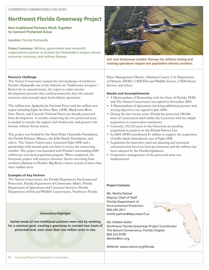
Jets over Greenway corridor–fl yways for military testing and training operations require low population density corridors.
Water Management District, Okaloosa County, U.S. Department of Defense (DOD), USDI Fish and Wildlife Service, USDA Forest Service, and others.
Results and Accomplishments• A Memorandum of Partnership with the State of Florida, DOD,
and The Nature Conservancy was signed in November 2003.• A Memorandum of Agreement involving additional partners and
setting objectives was signed in July 2004.• During the last twenty years, Florida has protected 100,686
acres of conservation land within the Greenway with fee simple acquisition or conservation easements.
• Currently, 152,523 acres in the Greenway are pending acquisition as projects on the Florida Forever List.
• In 2004, DOD contributed $1 million to support the acquisition of buffer lands immediately east of Eglin AFB.
• Legislation for innovative land use planning and increased communication between local governments and the military has been adopted by the Florida legislature.
• Cooperative management of the protected areas was implemented.
50 Faces and Places of Cooperative Conservation

Faces and Places of Cooperative Conservation 51
COOPERATIVE CONSERVATION CASE STUDY
Onslow Bight Conservation Forum
Conserving Ecosystems from Cape Lookout to Cape Fear
Location: Coastal North Carolina
Project Summary: Regional collaboration across nine counties on the Atlantic coastal plain to conserve saltwater marshes, long leaf savannahs, estuaries, wetlands, and pocosins.
Innovation/Highlight
The Forum represents a unique partnership between military units who are concerned about incompatible land use and
encroachment around their installations and traditional conservation organizations in the region.
Project Contacts
Mr. Fred AnnandAssociate Director of Conservation The Nature ConservancyNorth Carolina [email protected]
John TownsonNatural Resources ManagerU.S. Marine Corps Base Camp [email protected]
Resource ChallengeCoastal North Carolina’s Onslow Bight stretches from Cape Lookout to Cape Fear. A rich mosaic of saltwater marshes, wetlands, longleaf pine savannahs, and other coastal ecosystems, it supports several rare and endangered plant and animal species, including the Red-cockaded woodpecker. The region is developing rapidly and beginning to lose its rural character and ecological integrity.
The Onslow Bight Conservation Forum was jointly initiated by The Nature Conservancy and Camp Lejeune in response to encroachment issues at the military installation. Most of the partners own land in the region. Partners represent a broad spectrum of land managers and conservation advocates who are working to identify areas that should remain natural, develop political support for land acquisition, and work toward acquiring these lands.
Examples of Key Partners The Nature Conservancy North Carolina Chapter, North Carolina Coastal Federation, North Carolina Coastal Land Trust, Endangered Species Coalition, Wildlife Resources Commission, Department of Environment and Natural Resources, Marine Corps Base Camp Lejeune, Marine Corps Air Station Cherry Point, USDI Fish and Wildlife Service, Raleigh, USDA Forest Service Region 8.
A group of volunteers restore a marsh in the North River as part of the Coastal Federation’s ongoing efforts to restore wetlands.
Results and AccomplishmentsThe Onslow Bight Conservation Forum was instrumental in protecting 2,400 acres adjacent to the Camp Lejeune tank and rifl e ranges—land once slated for development with more than 3,000 housing units. Besides being a serious encroachment threat to the Marine Corps, the potential for noise complaints from homeowners was staggering. Development would have caused further habitat loss and placed greater demands on federal and state lands to maintain the region’s biodiversity. In 2003, The Nature Conservancy purchased the parcel using funds pooled from participants. In exchange for its contribution, the Marine Corps obtained a restrictive easement governing property development. For its contribution, the State of North Carolina obtained title to the property, which is now part of the state’s game preserve system, and open for public use.

Project Contact
Silmarie PadronPartners for Fish and Wildlife CoordinatorCaribbean Field Offi ce [email protected]
Websites:http://www.fws.gov/caribbean-ecoteam/shade_coffee_FS.pdf, http://www.haciendaverde.org/, http://www.haciendapellejas.com/
COOPERATIVE CONSERVATION CASE STUDY
Restoring Shaded Coffee Plantations in Puerto Rico
Sustainable Agriculture Supports Landscape-level Conservation
Location: Puerto Rico
Project Summary: Project provides incentives and assistance to coffee growers to return “sun” coffee plantations to shade, improving environment and wildlife habitat.
Innovation/Highlight
Encouraging coffee growers to return to more ecologically sound farming practices via cost-share incentives and
state-of-the-art technical assistance.
Resource ChallengeShaded coffee plantations are a simple but stable agro-ecosystem that can be an important wildlife management tool. A shaded canopy provides most of the ecological functions of the natural environment, including soil conservation, nutrient recycling, habitat for native, endemic and migratory birds, shelter for many plant and wildlife species, and buffer zones around protected areas. Most of Puerto Rico’s native and endemic species, such as the endangered Puerto Rican Boa, the Puerto Rican Vireo, the Puerto Rican Tody, and the Puerto Rican Screech owl use shaded coffee plantations for feeding, nesting, and shelter, as do Neotropical migrants that return to the continental United States.
The benefi ts of shaded coffee plantations are being lost due to “sun” coffee plantations—monocultures of plants without protection from native shade trees. Without shade trees, critical ecological processes are interrupted or eliminated, resulting in loss of habitat, sedimentation, water pollution, and loss of fertile soils and productive agricultural lands.
Although most farmers prefer shaded plantations because they last longer and produce higher quality beans, government subsidies are encouraging conversion to the sun plantations, which generally produce higher yields.
Examples of Key Partners USDI Fish and Wildlife Service (FWS, USDA Forest Service and USDA Natural Resources Conservation Service, Puerto Rico Departments of Natural Resources, Agriculture, and Extension Service; University of Puerto Rico, Hacienda Central Pellejas Inc.,
Harvesting shade-grown coffee in Ciales, Puerto Rico.
Hacienda Verde Inc., Hacienda Luisa Inc., Café del Alba Coffee Co., Puerto Rico Conservation Trust, EnviroSurvey Inc., Puerto Rico Association of Conservation Districts, and hundreds of coffee growers.
Results and AccomplishmentsThe Fish and Wildlife Service’s Partners for Fish & Wildlife Program is working with coffee growers in the Caribbean, encouraging them to voluntarily restore native shading canopy in coffee plantations. Specialists work with growers, explaining that although farmers get 20 percent fewer beans from shade plantations, the beans often weigh more, so the net weight is actually higher. Moreover, shaded plantations last a lifetime, while sun plantations must be replaced every eight to ten years. Finally, other crops such as bananas, avocados, and oranges can be grown to shade the coffee, producing more income.
Since restoration began in 2001, more than 1,000 acres of shaded habitat have been restored. The Puerto Rico Department of Natural Resources, FWS, and non-government organizations are providing the trees, as well as funds and/or technical assistance. Partnering corporations also help by promoting sustainable growing practices.
52 Faces and Places of Cooperative Conservation

Faces and Places of Cooperative Conservation 53
Project Contact
David LedfordSoutheast Initiative Program DirectorRocky Mountain Elk Foundation [email protected]
Website: www.rmef.org/bugle/pages/05MA/appalachian_1.html
COOPERATIVE CONSERVATION CASE STUDY
Southern Appalachian Elk Restoration
Returning Wild Elk to the East
Location: Kentucky, Tennessee, North Carolina
Project Summary: Restoration of elk to its historic eastern range is underway in the southern Appalachians, with elk populations in Kentucky now exceeding 5,550.
Innovation/Highlight
Successfully returned the elk to part of its former range in the eastern U.S.
Resource ChallengeThree hundred years ago, the Southern Appalachians were a place of mountains, oak savannahs, chestnut forests, and clear streams, where elk, bison, and white-tailed deer roamed in abundance. When European settlers arrived in the 1700s, they hunted without restraint. Bison were gone by 1800, followed by elk 50 years later. By 1900, even deer were scarce.
In 1988, the Great Smokey Mountains National Park began to study the possibility of returning elk to their native range. A decade later, the Kentucky Department of Fish and Wildlife Resources and the Rocky Mountain Elk Foundation released seven elk onto reclaimed coal mining lands. More than 3,500 people, including hundreds of schoolchildren, watched as elk made tracks in Kentucky soil for the fi rst time in seven generations. The state released another 1,500 elk at eight sites during the next fi ve years.
Examples of Key PartnersRocky Mountain Elk Foundation, Kentucky and Tennessee natural resources and wildlife agencies, USDI Offi ce of Surface Mining, USDA Forest Service, Tennessee Wildlife Federation, American Wildlife Conservation Partners, University of Tennessee, University of Kentucky, The Conservation Fund, Southeast Kentucky Tourism Development Association, Kentucky Coal Association, Friends of the Smokies, Campbell Outdoor Recreation Association, Middle Tennessee State University’s Offi ce of Instructional Technology and Center for Environmental Education.
View of Appalchian Mountains in the southeast United States, site of the Southern Appalachian Elk Restoration project.
Results and AccomplishmentsToday, east Kentucky’s elk population stands at about 5,500, and is growing by 15 percent annually. Tennessee has released 167 elk; Kentucky elk are already migrating there, mixing with and augmenting that population. The Great Smoky Mountains National Park began its experimental project in 2000, where the herd now stands at 60.
In 2001, elk hunting returned to Kentucky for the fi rst time in 160 years. Since then, hunters have taken about 200 wild elk and could be harvesting up to 1,500 elk per year within fi ve years.
As people have realized the connection between elk and the amount of suitable habitat, new conservation efforts have sprung up, including land acquisitions, conservation easements, habitat improvement projects, and changes in land management policy. Kentucky has been revising reclamation guidelines for coal surface mines to encourage creation of elk-friendly habitat. State natural resource agencies, coal mining organizations, and 25 conservation groups have been working on the revisions.
Elk are boosting local tourism, bringing economic development interests and rural communities into the partnership as they realize the need to conserve the habitat that supports the elk.

COOPERATIVE CONSERVATION CASE STUDY
South Florida Ecosystem Restoration
Cooperation Underlies Successes in Restoring the Everglades
Location: Kissimmee River Basin, Lake Okeechobee, the Everglades, and Florida Keys, Florida
Project Summary: Governments, tribes, NGO’s and others cooperate to restore the Everglades while addressing water supply and fl ood control needs of a rapidly developing region.
Innovation/Highlight
Orchestrating extensive cross-jurisdictional public and private cooperation to implement complex,
innovative water storage and wetlands treatment technologies to facilitate Everglades restoration.
Project Contact
Greg MayOffi ce of the Executive DirectorSouth Florida Ecosystem Restoration Task [email protected]
Website: www.sfrestore.org
Resource ChallengeSouth Florida is one of the most sensitive ecosystems in the world, its degradation a challenge of national signifi cance. The major cause is a massive drainage project, begun in the late 1800s and completed in the 1970s, which stretches from just south of Orlando to Florida Bay. It has delivered polluted runoff from agricultural and urban communities to the Everglades, over-drained the ecosystem, and destroyed millions of acres of wetlands. Challenges include how to recover the ability to store water that currently drains off the land, and how to clean up polluted runoff before it reaches sensitive water bodies such as the Everglades, Lake Okeechobee, the Florida Keys, and coastal estuaries.
Examples of Key PartnersCity of South Bay, Miami-Dade County, South Florida Water Management District, Miccosukee Tribe of Indians of Florida, Seminole Tribe of Florida, State of Florida and its associated agencies, the U.S. Environmental Protection Agency (EPA), the National Oceanic and Atmospheric Administration (NOAA), USDI, USDA, Department of Defense ( Army Corps of Engineers), U.S. Department of Transportation, the Justice Department, and others.
Results and AccomplishmentsThis complex, challenging restoration is being carried out by a combination of federal, state, local, and tribal initiatives. To facilitate the coordination of these initiatives, Congress established the intergovernmental South Florida Ecosystem Restoration Task Force in 1996. A Florida-based Working Group, a Science Coordination Group, and several other ad hoc advisory committees assist the Task Force in fulfi lling its responsibilities. These federal, state,
This Miccosukee Tribe Village on the Tamiami Trail is surrounded by wetlands.
local, and tribal representatives are working cooperatively and communicating with all stakeholders in an unprecedented, multi-decade conservation endeavor. Together, they are working to restore a healthy ecosystem that supports diverse, sustainable communities of plants, animals, and people, while meeting the water supply and fl ood control needs of the contiguous urban and agricultural communities.
Specifi c accomplishments include:
• Secured passage of the Comprehensive Everglades Restoration Plan (CERP) by Congress in 2000.
• Launched extensive land acquisition projects, including 107,000 acres to expand the Everglades National Park, and approximately 50 percent of the land needed for water management improvements called for in the CERP.
• Restored approximately one third of the Kissimmee River to its natural state.
54 Faces and Places of Cooperative Conservation

Faces and Places of Cooperative Conservation 55
COOPERATIVE CONSERVATION CASE STUDY
Suwannee River Partnership
Non-regulatory Best Management Practices Protect Water Quality
Location: North & Central Florida
Project Summary: The Partnership is working with producers to improve river water quality through a voluntary program of Best Management Practices (BMP) and verifi cation.
Innovation/Highlight
The Partnership developed “reasonable assurance” documentation showing that its non-regulatory watershed
management programs successfully improved water quality for the Suwannee River.
Project Contact
Jeffrey WoodsAssistant State Conservationist for ProgramsNatural Resources Conservation Service352-338-9515jeffrey.woods@fl .usda.gov
Resource ChallengeThe Suwannee River arises from the famous Okefenokee Swamp. From Georgia, the River fl ows through north Florida before emptying into the Gulf of Mexico. Along its path, it is fed by springs that bubble to the surface from the massive Floridian aquifer, which underlies all of Florida and South Georgia. The watershed spans nearly 10,000 square miles.
Formed in 1999, the Suwannee River Partnership began with 24 state, federal, and regional agencies, local governments, and private industry members. The Partnership’s focus was the Middle Suwannee Watershed, where in some areas, nitrates and nitrogen in groundwater and springs were well in excess of drinking water standards. In 2003, the Partnership expanded its work to include the Santa Fe River Basin.
The Partnership’s primary goal is to improve and protect water quality in the Suwannee and the dozens of crystal clear springs that feed it. They seek a balance between protecting natural resources and sustaining the region’s agricultural economy.
Fifty-three partners strong, the coalition has mobilized 89 percent of the dairies and 94 percent of the poultry farms in Florida’s Suwannee River Basin to participate in a voluntary conservation and nutrient management program.
Examples of Key PartnersUSDA Natural Resources Conservation Service (NRCS), Florida Department of Agriculture and Consumer Services, Florida Department of Environmental Protection, Florida Farm Bureau,
CARES (County Alliance for Responsible Environmental Stewardship) dinner and awards sponsored by the Suwannee River Partnership.
Suwannee River Water Management District, University of Florida, Institute of Foods and Agricultural Sciences.
Results and AccomplishmentsNoteworthy accomplishments of the Suwannee River Partnership include:
• The Partnership established a Quality Assurance Program that uses fi eld technicians to help farmers implement BMPs. Specialists verify and document that BMPs are applied properly, reporting results to the Partnership and tracking long-term success in reducing contamination.
• Thirty-nine of 44 dairies and 168 of 178 poultry producers are developing conservation plans and applying BMPs that meet or exceed state regulatory requirements. Primary tools are the PL-566 - Small Watershed Program and Environmental Quality Incentive Program.
• Under the PL 566 Small Watershed Program, $8.7 million in federal dollars have been pledged to poultry, dairy, and swine producers to develop on-farm waste management systems. In addition, $15.5 million in Environmental Quality Incentives Program (EQIP) dollars have been obligated to address confi ned livestock, plant and animal health, soil erosion, and water quality. Nearly 30,000 acres are enrolled in the Wetland Reserve Program, and 3,497 acres under Wildlife Habitat Incentive Program contracts.

Project Contact
Robert JosephPark ManagerTalbot Island State ParksFlorida State Park [email protected] .us
Website: www.nps.gov/timu/
COOPERATIVE CONSERVATION CASE STUDY
Timucuan Ecological and Historic Preserve
Joint Management Enhances 46,000-acre Wetland Preserve
Location: Jacksonville, Florida
Project Summary: Federal, state, and city agencies manage the 46,000-acre Timucuan Preserve and surrounding state and local parks as an integrated unit.
Innovation/Highlight
Created a cooperative management zone covering all of the Timucuan Preserve and surrounding city and state parks.
Resource ChallengeThe Timucuan Ecological and Historic Preserve protects one of the last unspoiled wetlands on the Atlantic Coast. Thousands of acres of marshes and creeks provide habitat for birds and fi sh as well as juvenile shrimp, crabs, and invertebrates. The Preserve also protects the area where fresh water enters the estuary and mixes with salt water, a zone that is particularly rich with species.
To conserve and protect Timucuan Preserve, managers are faced with two major challenges. The fi rst is how to conserve and protect the Preserve’s 46,000-acre core when the activities and management strategies of surrounding lands can—and do—affect its fragile ecosystem. The second issue is how to provide a quality, seamless recreational experience to the public in an environment of multiple land ownerships. These goals are particularly hard to achieve because Timucuan Preserve is surrounded by state and local jurisdictions with different management strategies and recreational policies, confusing to a user who sees a single resource, not intertwined jurisdictions.
Examples of Key PartnersCity of Jacksonville Department of Parks, Recreation and Entertainment; State of Florida Department of Environmental Protection-Coastal and Aquatic Managed Areas, State of Florida Division of Recreation and Parks, USDI National Park Service, and The Nature Conservancy.
The Kingsley Plantation includes the plantation house, a kitchen house, a barn, and the ruins of 25 of the original slave cabins.
Results and AccomplishmentsThe National Park Service, the State of Florida, and the city of Jacksonville signed an agreement establishing a cooperative management zone across the entire conservation landscape. The three parties agreed to collaboratively manage across their respective jurisdictions to enhance overall conservation and recreation management, to share staff and physical resources, and to co-manage visitor centers to provide seamless service, including conservation education to the visiting public. Through the partnership, land acquisition funds were leveraged among the various agencies to purchase lands for preservation and recreation. The partners prioritized purchases, which helped prevent agencies from working at cross purposes by trying to buy the same parcel of land. The group recently began a new partnership with the Florida Department of Environmental Protection-Coastal and Aquatic Managed Areas Division for long term water quality sampling. The Nature Conservancy has helped inventory and jointly manage 100 islands.
56 Faces and Places of Cooperative Conservation
Faces and Places of Cooperative Conservation 57
Project Contact
Michael BeanWildlife ChairEnvironmental Defense202-387-3500 [email protected]
COOPERATIVE CONSERVATION CASE STUDY
Enlisting Private Landowners and the Army for Endangered Species
Army and Landowners Embrace New Conservation Approaches
Location: Southeast
Project Summary: Safe Harbor Agreements and compatible use buffers used on and off Army bases contribute to the recovery of the endangered red-cockaded woodpecker.
Innovation/Highlight
Safe Harbor Agreements help more than two dozen endangered species on three million acres of privately-owned land.
Resource ChallengeThe red-cockaded woodpecker, an endangered species native to southeastern pine forests, lives on many military bases and on privately-owned lands, presenting challenges to both groups of landowners. For the military, the challenge is to continue to train troops effectively while meeting the requirements of the Endangered Species Act. For private landowners, the challenge is similar: forest management activities often create more woodpecker habitat—and more woodpeckers—which potentially subjects the landowner to increased regulation of his or her land. Also, if private landowners do not manage their forest land in ways that help the woodpecker, military bases are likely to support a growing percentage of an ever-declining woodpecker population in many areas.
Examples of Key PartnersU.S. Army, USDI Fish and Wildlife Service (FWS), Environmental Defense, state natural resource departments, and more than 200 landowners.
Results and AccomplishmentsStarting in the Sandhills region of North Carolina around Fort Bragg, FWS introduced the concept of endangered species “Safe Harbor Agreements.” Under these agreements, landowners who initiate forest management activities designed to improve conditions for the woodpecker, such as prescribed burning, selective tree harvests, and installing artifi cial nesting and roosting cavities, are assured of no new regulatory restrictions under the Endangered Species Act. Fort Bragg helped the FWS improve its outreach to landowners, and Environmental Defense helped design the program. Today, 91 Sandhills-area landowners, including owners of golf courses, horse
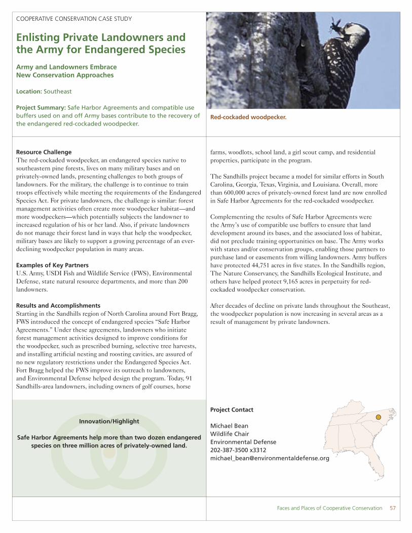
Red-cockaded woodpecker.
farms, woodlots, school land, a girl scout camp, and residential properties, participate in the program. The Sandhills project became a model for similar efforts in South Carolina, Georgia, Texas, Virginia, and Louisiana. Overall, more than 600,000 acres of privately-owned forest land are now enrolled in Safe Harbor Agreements for the red-cockaded woodpecker. Complementing the results of Safe Harbor Agreements were the Army’s use of compatible use buffers to ensure that land development around its bases, and the associated loss of habitat, did not preclude training opportunities on base. The Army works with states and/or conservation groups, enabling those partners to purchase land or easements from willing landowners. Army buffers have protected 44,751 acres in fi ve states. In the Sandhills region, The Nature Conservancy, the Sandhills Ecological Institute, and others have helped protect 9,165 acres in perpetuity for red-cockaded woodpecker conservation.
After decades of decline on private lands throughout the Southeast, the woodpecker population is now increasing in several areas as a result of management by private landowners.

Project Contact
Roger BanksChairmanWinyah Bay Focus Area Task [email protected]
COOPERATIVE CONSERVATION CASE STUDY
Winyah Bay Focus Area
Conserving the East’s Third Largest Coastal Estuary
Location: Winyah Bay, South Carolina
Project Summary: Broad-based coalition is conserving South Carolina’s coastal Winyah Bay watershed by land acquisitions, conservation easements, and wetland restoration.
Innovation/Highlight
Public/private coalition protects and restores coastal habitat.
Resource ChallengeWinyah Bay, the East coast’s third largest estuary, is fed by fi ve major rivers. The lower watershed, lazy with the slow, shallow, swampy marshes of the South, sustains 123,000 acres of forested wetlands and 23,000 acres of tidal freshwater marshes. Migratory songbirds, more than 40,000 wintering waterfowl, and six Federally-listed species fi nd vital habitat there. The region’s natural and historic assets, from its bays and salt marshes to the freshwater marshes of its former rice plantations, are drawing an increasing number of tourists, photographers, anglers, hunters, and naturalists.
Agriculture, industry, and other human activities, both past and present, have taken their toll. Nestled adjacent to the rapidly-developing Myrtle Beach area, urban growth and habitat fragmentation are threatening native upland, wetland, and dune communities, as well as threatened and endangered species such as the Red-cockaded woodpecker and Wood Stork.
The Winyah Bay Focus Area Task Force, a coalition of public and private organizations, was founded in 1992 under the Atlantic Coast Joint Venture of the North American Waterfowl Management Plan to seek landscape-level solutions to the watershed’s problems. Partners provide public information, donate staff time and funds, seek grants for projects, and provide technical expertise.
Examples of Key Partners USDI Fish and Wildlife Service, Historic Ricefi elds Association, South Carolina Department of Natural Resources, Ducks Unlimited,
Winyah Bay Focus Area partners at work restoring wetland vegetation.
The Nature Conservancy, Lowcountry Open Land Trust, 30 private landowners, and more than 100 businesses.
Results and AccomplishmentsAccomplishments of the Winyah Bay Focus Area Task Force include:
• Developed and built support for an innovative fee-based mitigation solution to compensate for the impacts of a major highway project on 200 acres of wetlands.
• Protected more than17,000 acres of forested fl oodplain and old growth longleaf pine using $12 million in public and private funds.
• Established the Waccamaw National Wildlife Refuge with community support.
• Protected 13,000 acres of private lands with permanent conservation easements.
• Enhanced or restored 4,000 acres of privately-held wetlands.• Established subcommittees to address local issues such as
migratory bird habitat and invasive plants. • Created an outreach program, including a Winyah Bay fi lm that
was a fi nalist at the International Wildlife Film Festival.• Protected a 9,000-acre portion of Sandy Island in Winyah Bay
in cooperation with federal and state agencies outside the Task Force.
Since the creation of the Task Force in 1992, its partners have protected more than 56,000 acres in the coastal wetlands of Winyah Bay.
58 Faces and Places of Cooperative Conservation