cartographic communication / its place in the theory of science
TRANSCRIPT
CARTOGRAPHIC COMMUNICATION / ITS PLACE IN THE THEORY OF SCIENCE
K A SALICHTCHEV
Moscow State University / Moscow Translated by James R Gibson / York University
ABSTRACT The author analyzes the view that the chief role of a map is the transmission of spatial information and that the task of cartography is restricted to the verification, elaboration, and the perfection of the methods of such transmission. It is asserted that the communication interpretation of cartography, although useful for the perfection of map language, cannot underlie the elaboration of a general theory of cartography. Modelling theory, based upon the dialectical-materialistic theory of reflection, affords a broader and more reliable basis for such a theory.
In the Soviet Union the conception of cartography has two aspects: the technical view, which sees cartography as the science of geographical maps and the methods of making and using them, and the broader view, which frequently sees cartography as a scientific method of understanding reality by means of geographical maps as graphic-symbolic spatial models of the real world.
At the same time in world cartography from the beginning of the 1970s there became widespread the view that the main role of geographical maps was communication, that is, the representation and transmission of spatial information by means of maps, and cartography's task was reduced to the verification, elaboration, and perfection of the methods of transmission.
Actually, in terms of graphicacy, objectivity, and localization maps are indispen-sible as repositors and transmitters of information on the distribution of features, phenomena, and processes and their condition, spatial links, relationships, and dynamics. On maps this information acquires an actual existence, and through maps it is disseminated and transmitted to posterity. This is the main purpose and value of widely-used maps (e.g., school, tourist, and many other maps) .
At the same time a great many maps, including the results of initial surveys and original research, as well as derivative scientific reference maps, provide investigators with a very effective means of acquiring new information. This leads to the natural conclusion that although cartography does relate to the interests of information specialists studying the processes of communication (that is, the presentation, transmission, and receipt of information), it is incorrectly regarded as a branch or subdivision of the study of information, since the latter does not set itself the task of evaluating the veracity and usefulness of information and does not devise methods for logically processing it with the aim of obtaining new information. Especially questionable, and in my view unacceptable, is the striving to base mapping processes as a whole upon a mathematical theory of information. This stems from ideas on the linear transmission of information along a channel of links with obstacles that cause distortion and loss of information. Such an approach reduces the tasks of cartography to merely the lessening of the loss of cartographic communication and excludes concern for the expansion of information.
I think that a clearer conception of mapping as a process of communication, based upon a mathematical theory of information, was expressed in 1972 at the Sixth International Cartographic Conference in Ottawa by Professor Joel Morrison,1 one of
The translation of this article, which was written expressly for The Canadian Cartographer, was prepared by JAMES R. GIB SON, Professor of Geography, Department of Geography, York University, Toronto, Canada.
1 Morrison, Joel L., "Changing Philosophical-Technical Aspects of Thematic Cartography," The American Cartographer, vol. 1 ( 1974), pp. 5-14.
THE CANADIAN CARTOGRAPHER Vol 15 No 2 December 1978 pp 93-99
the talented representatives of the cartographic school of the University of Wisconsin-Madison developed by Professor Arthur Robinson.
At the same time a similar view of cartography came from the late, well-knownPolish cartographer Lech Ratajski, 2 who headed the International CartographicAssociation's Commission V on Cartographic Communication, established in 1972 withthe aim of determining the principles of cartographic communication and facilitatingthe perfection of the means of cartographic communication. But the commissionexpanded its purview right up to the elaboration of a general theory of science andadopted the communication viewpoint of cartography on the basis of a mathematicaltheory of information as the foundation of theoretical research. 3
This position was criticized by me in 1973, specifically in an article in TheCanadian Cartographer; 4 and in 1975 I opposed the communication conception ofcartography in its evolved form as a particular scientific method of cognition. 5
Apparently this criticism prompted a definite change in the fundamental views of theadherents to the communication conception of cartography, and at the same timeevoked attempts to defend them. 6 It is not necessary to give a detailed account here ofthe substance of the discussion, since I have already done so in Tasks of Science andTechnology: Cartography. 7 In general the impression has been created that Com-mission V has made an about-face and has in essence drawn nearer to my conceptionof cartography as a cognitive science. In this connection I quote the commission'schairman, Professor Ratajski, who in 1976 explained the evolution of his views in thefollowing way: "One of its [the former conception's] most important deficiencies wasits too mechanistic approach which suggested the loss in information in the process ofits transmission, while an essential factor of the change in the quality of informationescaped general attention.... It seems that the cartographers, having been fascinatedtoo much by the theory of information, do not see quite clearly the role of cartographyin the categories of the theory of knowledge. "8
Similarly Morrison, who used to regard cartography as a science of com-munication, has come to believe that a cartographer must understand the essence ofthe phenomena being mapped, and he includes in the processes of communication
2 Ratajski, Lech, "The Research Structure of Theoretical Cartography, " International Yearbookof Cartography, vol. 13 (1973), pp. 2 17—228.3 Ratajski, Lech, "Commission v of IOA: The Tasks It Faces, " International Yearbook ofCartography, vol. 14 (1974), pp. 140—144.4 Salichtchev, K. A., "Some Reflections on the Subject and Method of Cartography after theSixth International Cartographic Conference, " The Canadian Cartographer, vol. 10 (1973), pp.106-111.5 Salichtchev, K. A., "O kartograficheskom metode poznaniya (analiz nekotorykh predstavleny okartografii)" ["Concerning the Cartographic Method of Cognition (An Analysis of CertainNotions of Cartography)"], Vestnik Moskovskovo universiteta: seriya geograficheskaya, vol. 16(1975). PP-3-10.0 The word "apparently" is used here because although Ratajski and Morrison in their subse-quent publications mention my articles in their sources, they do not refer to them directly as areason for the evolution of their views.7 Salichtchev, K. A., "Karty kak sredstvo kommunikatsii" ["Maps as a Means of Communication"],Itogi nauki i tekhniki: Kartografiya, vol. 8 (1978).8 Ratajski, Lech, "Cartology, its Developed Concept, " in Polish Cartography (Warsaw, 1976),PP- 7, 9.
CARTOGRAPHIC COMMUNICATION / ITS PLACE IN THE THEORY OF SCIENCE 95
the interpretation and analysis of information derived from the map, and this leadsto the acquisition of new knowledge.9
In general the notion that cartographic communication entails not only thetransmission but also the enrichment of information is now assumed in many carto-graphic schools. This notion was most fully expressed in 1976 by Arthur Robinson andBarbara Bartz Petchenik in the monograph The Nature of Maps.10 There was also anarticle by Professor Leonard Guelke of Canada with a convincing argument for thenecessity of a geographical basis for cartographic communication.11
All of this attests the fact that the vogue for the communication interpretation ofcartography, based as a whole upon a formal theory of information without considera-tion for the cognitive value of maps, is, like every vogue, gradually fading, and that ithas been replaced by a conception of cartography as a cognitive science that makeswide and sensible use of the varied achievements and methods of the study of informa-tion for the solution of specific tasks in the elaboration and perfection of the languageand content of geographical maps.
The shift in fundamental positions, however, has not been a smooth process. Inlife it often happens that there is a striving for partial retention of former positions(sometimes only in their phraseology) under the necessity of proceeding to othertheoretical lines. Just such a situation arose at a meeting in Hamburg on September15-17, 1977 of Commission V of the ICA.12 This event prompted renewed criticismof the narrow communication interpretation of cartography. At the Eighth Interna-tional Cartographic Conference in 1976 in Moscow the commission had been told thatits main task was the elaboration of models of cartographic communication, and a listof scientific research problems in this area had been presented. Proceeding to a resolu-tion of this task at Hamburg, the commission expanded the concept of cartographiccommunication to include — as an initial stage of communication — the study of realityby means of data collection and the interpretation of these data for possible representa-tion of this reality by cartographers, and - as a final stage - the interpretation of thedata by map readers. Neither stage is at all confined to the limits of information theory,and at the same time they lend an unjustified significance to the principles ofcartographic communication (based upon information theory) in the elaboration of ageneral theory of cartography. The latter is, as it were, a substitute for the theory ofcommunication.
In a keynote report at the meeting in Hamburg it was declared (with reference tothe Polish cartographer Jerzy Ostrowski) that there were several tendencies in currentelaborations of the theory of cartography.13 It was asserted that theoretical construc-
9 Morrison, Joel, "The Science of Cartography and its Essential Processes," International Year-book of Cartography, vol. 16 (1976), pp. 84-97.1() Robinson, Arthur H., and Barbara Bartz Petchenik, The Nature of Maps: Essays towardUnderstanding Maps and Mapping (Chicago, 1976).11 Guelke, Leonard, "Cartographic Communication and Geographic Understanding," TheCanadian Cartographer, vol. 13 (1976), pp. 107-122.12 All of the material of the Hamburg meeting was kindly given to me by Dr. Karl-Heinz Meine,the organizer of the meeting.13 Ratajski, Lech, "The Main Characteristics of Cartographic Communcation as a Part ofTheoretical Cartography," Material of the Meeting of Commission V of the ICA (Hamburg,1977)-
96 K A SALICHTCHEV
tions in cartography can be erected on different foundations — e.g., information theory,semiotics, modelling theory, metascience, epistemology — in accordance with thephilosophical views of the researcher. But these bases or, more properly, qualitativelydifferent conceptions, are of unequal significance and cannot oppose or replace eachother.
Epistemology is a philosophical discipline that investigates the nature of knowledgeand the relationship of knowledge to the real world. It has universal significance andis equally necessary to the correct orientation of research in any branch of science.
Metacartography (a little-used term, on the meaning of which there is noagreement) is in a special position. In the opinion of some cartographers it calls forthe determination of the essence and methods of cartography as a science and henceits organic adoption of theory.
As regards modelling, semiotics, and information theory, which pursue relativelyparticular ends, in their application to cartography they do not counteract (replace)but rather expediently supplement each other. Modelling — a cognitive method and aform of reflection of reality — is the essence of mapping as constructions of spatialgraphic-symbolic models of the real world. Semiotics investigates the characteristics ofsymbols and symbolic systems or, in its application to cartography, graphic map symbolsand systems of such symbols. Information theory studies and devises processes forstoring, transforming, and transmitting information; the totality of these processesconstitutes scientific communication. In cartography these processes proceed from theinitial devising of maps right up to and including the use of maps. Here there comesto mind the myth of the dispute of the three goddesses [over the apple of discord].Cartography should not emulate Paris by giving preference to one of them; it must takejudicious advantage of the gifts of each "goddess," each branch of science.
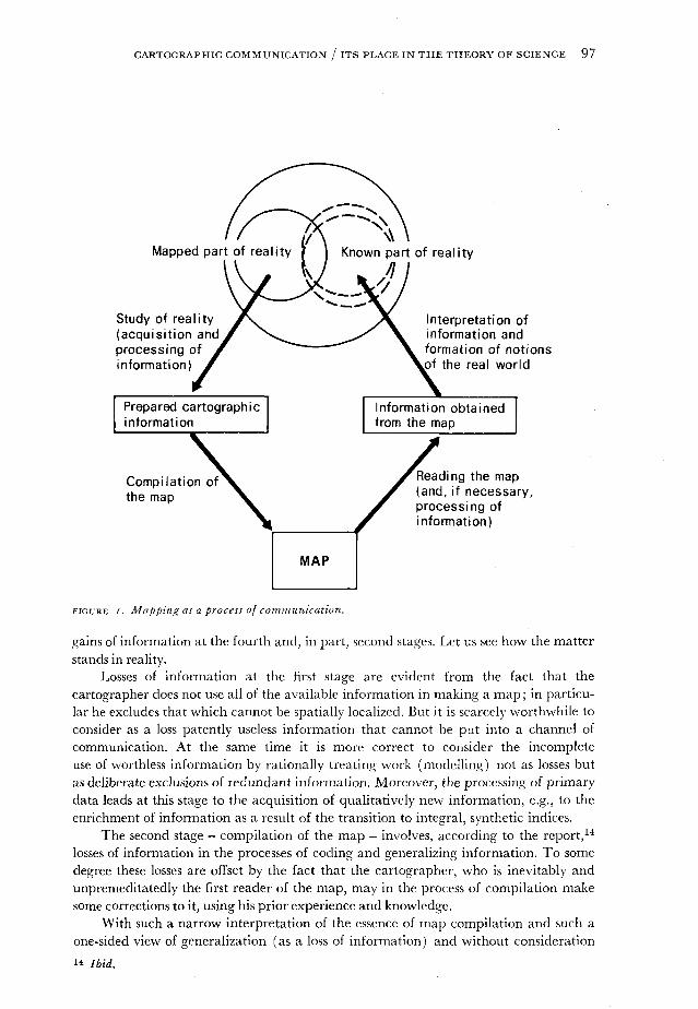
Meanwhile, in the aforementioned report mapping was as before discussedprimarily from the position of information theory as a process of communication, withthis process including all of the four stages of mapping (which are now widelyrecognized), namely: (i) the acquisition and processing of information as a result ofperception by the cartographer of fragments of reality of interest to him; (2) the com-pilation of the map as a bearer of information; (3) the perception (reading) of themap by a reader (if necessary, with additional processing of information, e.g., bymeans of cartometric work) ; and then (4) the interpretation of the informationobtained by the reader for the formation of his own ideas of the real world (Figure 1).
As is generally known, the mathematical theory of information in its pure formpresupposes at each stage of communication only losses of information, posing as itstask the reduction of such losses to a minimum. Now in examining these stages theaforementioned report also considered aspects of semiotics and modelling on theassumption that the application of semiotics to the second and third stages facilitatesthe perfection of map coding and decoding. But a glance at a map as a model of realitymakes clear an indisputable fact that is not explained by information theory, namely,the growth of information with the making and using of maps. This is fine. However,questions of the loss and gain of information are treated mainly from the standpoint ofinformation theory without heed for the essence of modelling, and this leads to incom-plete and partly incorrect notions. In the report it was pointed out that the losses ofinformation occur at the first, second, and third stages of communication, and the
CARTOGRAPHIC COMMUNICATION / ITS PLACE IN THE THEORY OF SCIENCE 97
FIGURE /. Mapping as a process of communication.
gains of information at the fourth and, in part, second stages. Let us see how the matterstands in reality.
Losses of information at the first stage are evident from the fact that thecartographer does not use all of the available information in making a map; in particu-lar he excludes that which cannot be spatially localized. But it is scarcely worthwhile toconsider as a loss patently useless information that cannot be put into a channel ofcommunication. At the same time it is more correct to consider the incompleteuse of worthless information by rationally treating work (modelling) not as losses butas deliberate exclusions of redundant information. Moreover, the processing of primarydata leads at this stage to the acquisition of qualitatively new information, e.g., to theenrichment of information as a result of the transition to integral, synthetic indices.
The second stage - compilation of the map - involves, according to the report,14
losses of information in the processes of coding and generalizing information. To somedegree these losses are offset by the fact that the cartographer, who is inevitably andunpremeditatedly the first reader of the map, may in the process of compilation makesome corrections to it, using his prior experience and knowledge.
With such a narrow interpretation of the essence of map compilation and such aone-sided view of generalization (as a loss of information) and without consideration
i* Ibid.
98 K A SALICHTCHEV
of the role of the mathematical factor, the spatial co-ordination of information is rootedin a basic defect of the communication model of mapping, namely, incomprehensionof the "sacraments" of map compilation. Two of them are especially important: firstly,the acquisition of qualitatively new information in the generalization of the originaldata, e.g., a geosystem of a higher hierarchical level following the transition to repre-sentation; and secondly, the formation of a spatial image of the phenomena beingmapped (for the first time, or at new hierarchical levels following research on newaspects of the phenomena, etc.). It is this very formation of a spatial image that explainsthe indisputable fact that the summary information given by the map can greatlyexceed the sum of information contained in the map's individual symbols, whichindicate the spatial situation, form, and certain characteristics of the depictedphenomena. The representation of spatial combinations and interrelationships and ofdistributional regularities provides this growth of information. This is precisely whystatistical banks of spatial data that are obtained for automatic processing in a computercannot replace geographical maps.
At the third stage - the stage of perception of the map by the reader - thereemerges all of the information contained in the individual symbols and their systemsbut it is not always fully utilized. Two reasons can be stated here: insufficient carto-graphic training of the reader and the reader's constructive exclusion of informationthat is useless to him. Only the first reason entails a real loss of information; the secondreason refers to the expedient filtration of information. In this connection it will beremembered that now topographic maps are often published in different variants thatpreserve these or those combinations of elements selected in accordance with the needsof a specific group of users. At the same time the processing of the extracted informa-tion by means (cartometry, mathematical-statistical analysis, and the like) used in thecartographic method of research can yield essentially new information on thephenomena being studied.
The fourth stage - interpretation of the information obtained from the map - hasas its chief aim the formation and expansion of ideas on mapped reality by enlistingthe reader's prior experience and knowledge. But experience and knowledge vary fromperson to person. This subjective factor explains the possible variations in the depthand the correctness of interpretation of reality (this is shown in Figure i as two dottednon-concentric circles). Evidently the fourth stage lies outside the limits of informationtheory.
Returning to the activities of Commission V of the ICA, it can be said with certaintythat its work will give a new impetus to research on the problem of cartographic com-munication. Familiarity with the material of the commission's meeting in Hamburgattests the variety and interest of the reports and opinions presented there.15 At thesame time they are prompting a vigorous expression of the view that is the conclusionof this article.
The communication interpretation of cartography, although useful for the per-15 For example, Karl-Heinz Meine emphasizes that the application of the principles of semioticsand modelling theory to cartography is unthinkable without generalization (K.H. Meine, "CertainAspects of Cartographic Communication in a System of Cartography as a Science," Material ofthe Meeting of Commission V of the ICA [Hamburg, 1977]). Meanwhile, generalization isexcluded from the conception of mapping as only a means of communication.
CARTOGRAPHIC COMMUNICATION / ITS PLACE IN THE THEORY OF SCIENCE 99
fection of map language, cannot underlie the elaboration of a general theory ofcartography, let alone replace it. Modelling theory, based upon the dialectical-materialistic theory of reflection, affords a broader and more reliable basis.
RÉSUMÉ L'auteur analyse le point de vue selon lequel le role principal d'une carte est la trans-mission de renseignements spatiaux et la tache du cartographe se borne a la verification, a1'elaboration et au perfectionnement des methodes de transmission. Il soutient que Interpretationde la cartographie axée sur la communication, malgré son utilité pour le perfectionnement dulangage cartographique, ne pent pas servir de base a 1'elaboration d'une theorie generale de lacartographie. La theorie de la modelisation, fondee sur la theorie de la reflexion du materialismedialectique, offre une base plus large et plus fiable pour la mise au point d'une theorie generalede la cartographie.
ZUSAMMENFASSUNG Der Verfasser analysiert die Ansicht, dass die Hauptrolle der Kartein der Ubermittlung raumlicher Informationen besteht und dass sich die Aufgabe der Karto-graphie auf die Uberprttfung, sorgfaltige Ausarbeitung und die Perfektion der Verfahren solcherUbermittlung beschrankt. Er stellt fest, dass diese Kommunikationsauslegung der Kartographie,obwohl brauchbar fiir die Perfektion der Kartensprache, nicht die Grundlage einer allgemeinenTheorie der Kartographie sein kann. Eine auf der dialektisch-materialistischen Reflektionstheorieaufgebaute Modellierungslehre liefert eine breitere und zuverlassigere Basis fiir eine solche Theorie.
RESUMEN El autor analiza el punto de vista de que el proposito principal de un mapa es latrasmision de informacion espacial y que la tarea de la cartografia se limite a la verificacion,elaboracion, y la perfeccion de los metodos de tal trasmision. Se declara que la definicion, de car-tografia como comunicacion, aunque sea litil para la perfeccion del idioma cartografico, nopuede subordinarse a la elaboracion de una teoria general de la cartografia. La teoria de modelo,basado en la teoria dialectico-materialistica de reflexion, ofrece una base mas amplia y de masconfianza para dicha teoria.