carter finley cemetery 2 relocation
TRANSCRIPT

FINAL REPORT
Historical and Archaeological Investigations at Carter-Finley Stadium Cemetery 2
(Archaeological Site 31WA1927**)
Raleigh, House Creek Township, Wake County, NC
Wake County NC PIN 0784366890/Real Estate ID 0232262
Prepared for
North Carolina State University
Raleigh, NC
Prepared by
Deborah Joy, MA, RPA, and Matthew I. Gill, MA
Legacy Research Associates
3333 Durham-Chapel Hill Blvd.
Suite A-100
Durham, NC 27707
2 July 2015

North Carolina State University Cemetery 2 Near Carter-Finley Stadium, 4600 Trinity Road
PIN 0784366890 Raleigh, House Creek Township, Wake County, NC 27606
Table of Contents
Introduction ...................................................................................................................................................................................................... 1
Scope of Work .............................................................................................................................................................................................. 2
Environmental Setting ............................................................................................................................................................................... 2
Cultural Context ............................................................................................................................................................................................ 5
Pioneer Model ........................................................................................................................................................................................... 6
Transitional Model ................................................................................................................................................................................. 6
African-American Cemetery Customs ....................................................................................................................................... 7
Modern Model ........................................................................................................................................................................................... 7
Previous Cemetery Research Near Carter-Finley Stadium .............................................................................................. 7
Historic Map Research ............................................................................................................................................................................. 9
Deed Research............................................................................................................................................................................................ 14
Chain of Title 1920 - Chamberlain to State Prison .................................................................................................. 14
Chain of Title 1912-1904 .............................................................................................................................................................. 16
Chain of Title 1902 - Andrews to Holderfield ............................................................................................................... 16
Chain of Title Pre-1902 Andrews Property in House Creek Township ......................................................... 17
Chain of Title for the 200 Acres Acquired 1886 ........................................................................................................ 18
Chain of Title for the 56.5 Acres Acquired 1888 ....................................................................................................... 18
Field Investigations ................................................................................................................................................................................... 19
Next of Kin Advertising Efforts ........................................................................................................................................................ 25
Summary of Investigations ................................................................................................................................................................. 26
Significance Evaluation .......................................................................................................................................................................... 27
Reinterment Site ........................................................................................................................................................................................ 27
References Cited ....................................................................................................................................................................................... 28
APPENDIX A – THE NORTH CAROLINA CEMETERY SURVEY ........................................................................................ 30
Page II

North Carolina State University Cemetery 2 Near Carter-Finley Stadium, 4600 Trinity Road
PIN 0784366890 Raleigh, House Creek Township, Wake County, NC 27606
List of Figures
Figure 1. Location of Carter-Finley Stadium west of Raleigh on present-day map. .................................................................... 3
Figure 2. Location of Cemetery 2 (Site 31WA1927**) on a contemporary aerial photograph that shows the wooded area surrounded by parking lots and the stadium. Note: The former location of Cemetery 1 and the Lincolnville AME Church Cemetery are also identified. ..................................................................................................... 4
Figure 3. Location of Cemetery 2 (Site 31WA1927**) on the Raleigh West, USGS topographic quadrangle map, 7.5-minute series. .................................................................................................................................................................................................. 4
Figure 4. Western edge of Cemetery 2 showing Gate 6, view north toward Carter-Finley Stadium. ............................. 5
Figure 5. Aerial photograph showing three cemeteries near Carter-Finley Stadium (Wake County iMAPS). ............. 8
Figure 6. Excerpt of the 1938 Camp Polk property map showing the location of the ¼-acre graveyard, now referred to as “Cemetery 2” (Wake County Plat Book 1938, page 5). .................................................................................... 9
Figure 7. Excerpt of Fendol Bever’s 1871 Map of Wake County, NC, showing the House Creek Township and the general project area (Reference URL: http://dc.lib.unc.edu/cdm/ref/collection/ncmaps/id/241). ......... 10
Figure 8. Excerpt of Shaeffer’s 1887 Map of Wake County, NC, showing the House Creek Township and the general project area (Reference URL: http://dc.lib.unc.edu/cdm/ref/collection/ncmaps/id/968). ................... 10
Figure 9. Excerpt of Clements 1904 School Map of Wake County, NC, showing the House Creek Township and the general project area (Reference URL: http://dc.lib.unc.edu/cdm/ref/collection/ncmaps/id/281).11
Figure 10. Excerpt of the Spoon’s 1911 Map of Wake County, NC, showing the House Creek Township and the general project area (Reference URL: http://dc.lib.unc.edu/cdm/ref/collection/ncmaps/id/419). ......... 11
Figure 11. Excerpt of the 1914 Wake County Soil Survey showing the general location of Carter-Finley Stadium that shows Cemetery 1, but no evidence of Cemetery 2 or the Lincolnville AME Church Cemetery. http://www2.lib.unc.edu/dc/ncmaps/interactive/MC_099_1914b.html. ........................................................... 12
Figure 12. 1971 Aerial photograph showing the small wooded area (Cemetery 2) east of Carter Stadium, as well as Cemetery 1 and the Lincolnville AME Church Cemetery (http://www2.lib.unc.edu/reference/gis/USDA/wake_1971/index.html). ................................................................................... 12
Figure 13. 1959 Aerial photograph of Carter Stadium showing the small wooded area (Cemetery 2) (http://www2.lib.unc.edu/reference/gis/USDA/wake_1959/index.html). ................................................................................... 13
Figure 14. 1938 Aerial photograph of Carter Stadium showing the small wooded area (Cemetery 2) (http://www2.lib.unc.edu/reference/gis/USDA/wake_1938/index.html). ................................................................................... 13
Figure 15. Identified Land Acquisition Records on the 1938 Camp Polk property map (see Figure 6). .................. 15
Figure 16. Excerpt of the 1920 land conveyance from JR Chamberlain and wife, HS Chamberlain, to State’s Prison (Wake County Deed Book 350, page 540). ................................................................................................................................ 15
Page III

North Carolina State University Cemetery 2 Near Carter-Finley Stadium, 4600 Trinity Road
PIN 0784366890 Raleigh, House Creek Township, Wake County, NC 27606
Figure 17. Excerpt of the 1902 land conveyance from Andrews to Holderfield (Wake County Deed Book 187,
page 372). ............................................................................................................................................................................................................................. 17
Figure 18. Excerpt of the 1888 land conveyance from Allen to Andrews (Wake County Deed Book 105, page 390). ........................................................................................................................................................................................................................................... 19
Figure 19. Cemetery 2, showing the general extent of the possible burials identified on a contemporary aerial photograph of Carter-Finley Stadium near Gate 6 (Wake County iMAPS). .......................................................................... 21
Figure 20. Cemetery 2 (Site 31WA1927**), plan map. .................................................................................................................................... 22
Figure 21. Cemetery 2 surface conditions and a potential Grave 2, view southeast toward the parking lot. .... 23
Figure 22. Cemetery 2 surface conditions and potential graves (pin flagged) with a quartz rock footstone at Grave 4, view east toward the RV parking lot. ......................................................................................................................................... 23
Figure 23. Grave 3 depression area with concrete mass, view west. .................................................................................................. 24
Figure 24. Close-up of Grave 4 with a quartz chunk that is a possible footstone. ................................................................ 24
Figure 25. Affidavit of Publication. .................................................................................................................................................................................. 25
List of Tables
Table 1. Summary of land conveyances from Chamberlain 1920 to Davis 1904. .............................................................. 16
Table 2. Holderfield Acquisition of ½-acre in House Creek Township. ........................................................................................ 16
Table 3. Andrews Property in House Creek Township Prior to 1902. ........................................................................................... 17
Table 4. Chain of Title for the 200 Acres Acquired in 1886. ............................................................................................................. 18
Table 5. W.M. Allen Property Chain of Title. ..................................................................................................................................................... 18
Page IV

North Carolina State University Cemetery 2 Near Carter-Finley Stadium, 4600 Trinity Road
PIN 0784366890 Raleigh, House Creek Township, Wake County, NC 27606
Grave Removal Petition Summary for the North Carolina State University Cemetery 2 near Carter-Finley Stadium
Current Address: 4600 Trinity Road, Raleigh, House Creek Township, Wake County, NC 27607
PIN Identification: 0784366890
The graveyard is located on 0.25 acres of land at 4600 Trinity Road that was acquired by the State of North Carolina on January 1, 1920, from J. R. (Joseph Redington) Chamberlain and wife, H. S. (Hope Summerell) Chamberlain (Wake County Deed Book 350:540).
See Figures 1-3 for the general cemetery location.
Number of Graves: Approximately 5
Approximately five graves were identified during the 2014 archaeological inspection (Figure 20). None of the possible graves had head or footstones.
Acreage: Approximately 0.25 acres
As a result of the investigation the cemetery size is determined to cover approximately 0.25 acres.
Advertising Efforts:
A legal notice of the intention to remove and reinter the graves at the unmarked cemetery was published in the Raleigh News & Observer on March 27, April 3, 10, and 17 of 2015. The advertisement was published in fulfillment of Section 65-106 of the General Statues of North Carolina and in an attempt to notify descendants and other interested parties. No response has been received.
See Figure 25 for a copy of the notarized affidavit of publication.
Relocation Address:
Oakwood Cemetery, 701 Oakwood Avenue, Raleigh, NC 27601
Parcel Identification Number 1714110503
Legacy Research Associates Page 1 of 30

North Carolina State University Cemetery 2 Near Carter-Finley Stadium, 4600 Trinity Road
PIN 0784366890 Raleigh, House Creek Township, Wake County, NC 27606
Introduction This technical report details the historic research and systematic archaeological exploration of a small unmarked cemetery identified as “Cemetery 2” on a ½ acre of wooded land adjacent to Carter-Finley Stadium in Raleigh, Wake County, NC. Historical documents refer to the cemetery within the ½ acre of land as comprising one-fourth of an acre. See Page 10 for a discussion of other cemeteries in this area. The work was conducted by Legacy Research Associates, in Durham, NC, for North Carolina State University (NCSU) in Raleigh, NC.
The stadium is part of the North Carolina State University (NCSU) campus and is located on Trinity Road approximately five miles west of downtown Raleigh (Figure 1). The stadium is home to the NCSU Wolfpack football team. It replaced Riddick Stadium (1907-1965) in 1966 and was originally named Carter Stadium in honor of Harry C. and Wilbert J. "Nick" Carter, both graduates of the University and major contributors to the original building of the stadium. It was renamed “Carter-Finley” in 1978 to honor Albert Earle Finley (1895-1985), another major contributor to the University.
Cemetery 2 is situated on land identified as Wake County Parcel Identification Number (PIN) 0784366890, Real Estate ID 0232262. It is southeast of the stadium and northwest of the intersection of Trinity Road and Peter Karmanos Jr Drive (Figure 2 and Figure 3).
Scope of Work The scope of work included conducting historic research that might provide information about the age of the cemetery and who may have been buried there and archaeological field investigations to identify and map possible burials. The purpose of the investigation was to provide historical and archaeological documentation of Cemetery 2 to NCSU for planning purposes.
NCSU plans to improve access to Carter-Finley Stadium near Gate 6, which is adjacent to Cemetery 2. The proposed improvements will expand the existing concourse area behind a new retaining wall and construct several new gates in order to (1) provide handicapped access to comply with the federal American with Disabilities Act, (2) improve gate admission efficiency, and (3) provide additional queuing for student access so as to eliminate pedestrian/automobile conflicts before and after football games and other events at the stadium."
Environmental Setting Cemetery 2 is located on a low-rising hilltop within a ½-acre wooded area that is surrounded by development associated with Carter-Finley Stadium. Immediately west of the hilltop are the entrance gates to the Carter-Finley Stadium and the southern end-zone (Figure 4). The hilltop appears to be frequently used as a pedestrian cut-through, as several footpaths cross through the wooded area. This pedestrian traffic and associated activity may be having an adverse effect on the graves. To the north, east, and south of the wooded area are multiple parking lots including a paved RV lot and rows of temporary game-day parking spots.
Soils within the wooded area are classified as Cecil clay loam, severely eroded. The upper portion of the hilltop is noted to be 2 to 6% slopes, while the areas on the north, west, and south have 6 to 10% slopes. These soils are typically situated on upland interfluves and side slopes with a parent material from
Legacy Research Associates Page 2 of 30

North Carolina State University Cemetery 2 Near Carter-Finley Stadium, 4600 Trinity Road
PIN 0784366890 Raleigh, House Creek Township, Wake County, NC 27606
saprolite derived from granite and gneiss. A typical profile includes roughly 8-inches of clay loam over 3-5 feet of clay.
The hilltop contains a mix of pine and oak trees with some dogwoods situated primarily on the more sun-exposed perimeter of the landform. Briars and poison ivy are common on the northeastern aspect of the hill.
Figure 1. Location of Carter-Finley Stadium west of Raleigh on present-day map.
Legacy Research Associates Page 3 of 30

North Carolina State University Cemetery 2 Near Carter-Finley Stadium, 4600 Trinity Road
PIN 0784366890 Raleigh, House Creek Township, Wake County, NC 27606
Figure 2. Location of Cemetery 2 (Site 31WA1927**) on a contemporary aerial photograph that shows the wooded area surrounded by parking lots and the stadium. Note: The former location of Cemetery 1 and
the Lincolnville AME Church Cemetery are also identified.
Figure 3. Location of Cemetery 2 (Site 31WA1927**) on the Raleigh West, USGS topographic quadrangle map, 7.5-minute series.
Legacy Research Associates Page 4 of 30

North Carolina State University Cemetery 2 Near Carter-Finley Stadium, 4600 Trinity Road
PIN 0784366890 Raleigh, House Creek Township, Wake County, NC 27606
Figure 4. Western edge of Cemetery 2 showing Gate 6, view north toward Carter-Finley Stadium.
Cultural Context The following summary information about historic cemeteries has been extracted and summarized from the website: http://www.sciway.net/hist/chicora/gravematters-1.html. Other references include Texas Cemeteries (Jordan 1982) and “The Southern Folk Cemetery in Piedmont North Carolina” (Clauser 1984). Some Southern cemetery traditions include wife-to-the-left burials, bordered family plots, and feet-to-the-east interments. Husband-to-the-right (or wife-to-the-left) is a traditional position of married couples in the Southern folk cemetery. This apparently derives from a British Christian belief that Eve was created from the left side of Adam. The basis of feet-to-the-east burials can be linked to sun worship cults found in Europe at the advent of Christianity. The Southern folk cemetery is characterized further by hilltop location, scraped ground surface, mounded graves, creative grave markers and decorations using materials readily available (not commercially produced), certain species of vegetation, the use of grave shelters, and the obvious devotion to God and/or parents and family with the graveyard workdays and monument dedications. The presence of most of these traits within one cemetery categorizes a cemetery as a folk cemetery. Since the regional distribution of this type of cemetery coincides with the Southern culture, this cemetery is known as “Southern Folk.”
Legacy Research Associates Page 5 of 30
North Carolina State University Cemetery 2 Near Carter-Finley Stadium, 4600 Trinity Road
PIN 0784366890 Raleigh, House Creek Township, Wake County, NC 27606
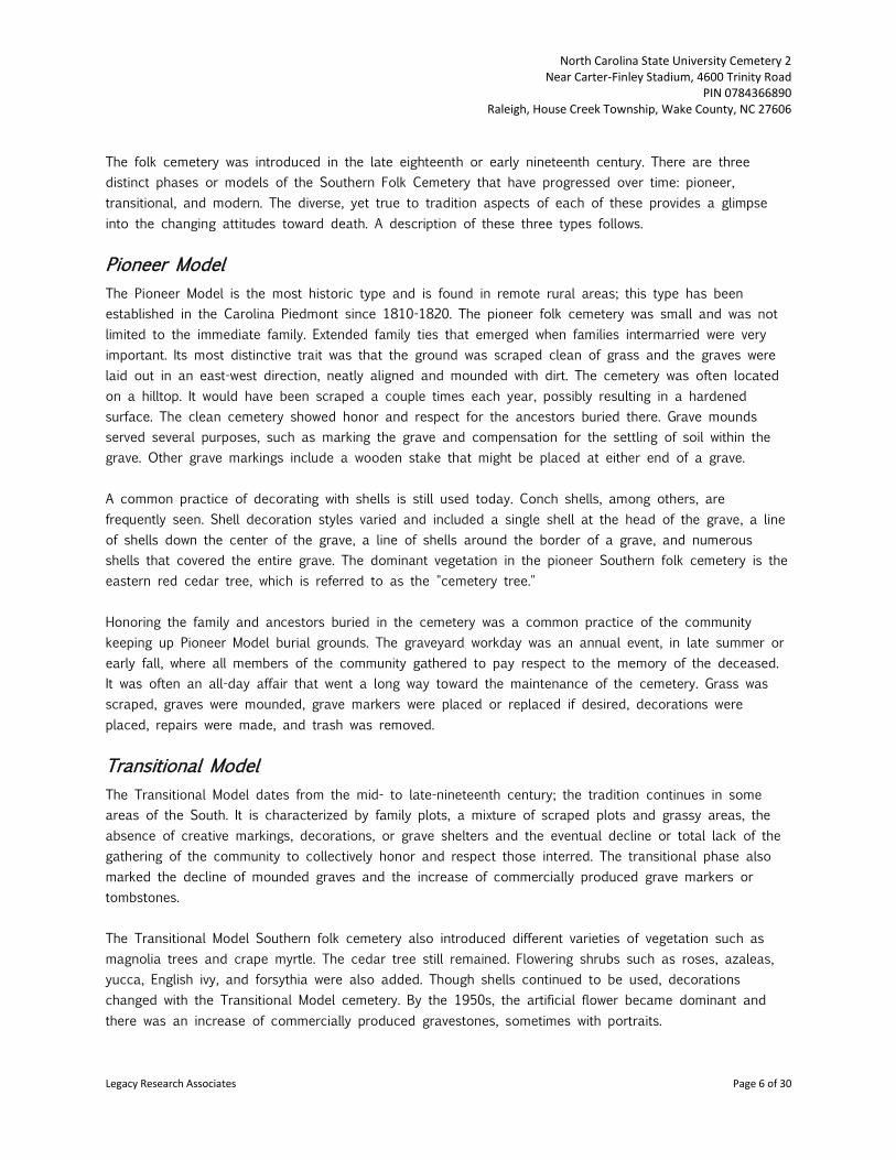
The folk cemetery was introduced in the late eighteenth or early nineteenth century. There are three distinct phases or models of the Southern Folk Cemetery that have progressed over time: pioneer, transitional, and modern. The diverse, yet true to tradition aspects of each of these provides a glimpse into the changing attitudes toward death. A description of these three types follows.
Pioneer Model The Pioneer Model is the most historic type and is found in remote rural areas; this type has been established in the Carolina Piedmont since 1810-1820. The pioneer folk cemetery was small and was not limited to the immediate family. Extended family ties that emerged when families intermarried were very important. Its most distinctive trait was that the ground was scraped clean of grass and the graves were laid out in an east-west direction, neatly aligned and mounded with dirt. The cemetery was often located on a hilltop. It would have been scraped a couple times each year, possibly resulting in a hardened surface. The clean cemetery showed honor and respect for the ancestors buried there. Grave mounds served several purposes, such as marking the grave and compensation for the settling of soil within the grave. Other grave markings include a wooden stake that might be placed at either end of a grave. A common practice of decorating with shells is still used today. Conch shells, among others, are frequently seen. Shell decoration styles varied and included a single shell at the head of the grave, a line of shells down the center of the grave, a line of shells around the border of a grave, and numerous shells that covered the entire grave. The dominant vegetation in the pioneer Southern folk cemetery is the eastern red cedar tree, which is referred to as the "cemetery tree." Honoring the family and ancestors buried in the cemetery was a common practice of the community keeping up Pioneer Model burial grounds. The graveyard workday was an annual event, in late summer or early fall, where all members of the community gathered to pay respect to the memory of the deceased. It was often an all-day affair that went a long way toward the maintenance of the cemetery. Grass was scraped, graves were mounded, grave markers were placed or replaced if desired, decorations were placed, repairs were made, and trash was removed.
Transitional Model The Transitional Model dates from the mid- to late-nineteenth century; the tradition continues in some areas of the South. It is characterized by family plots, a mixture of scraped plots and grassy areas, the absence of creative markings, decorations, or grave shelters and the eventual decline or total lack of the gathering of the community to collectively honor and respect those interred. The transitional phase also marked the decline of mounded graves and the increase of commercially produced grave markers or tombstones. The Transitional Model Southern folk cemetery also introduced different varieties of vegetation such as magnolia trees and crape myrtle. The cedar tree still remained. Flowering shrubs such as roses, azaleas, yucca, English ivy, and forsythia were also added. Though shells continued to be used, decorations changed with the Transitional Model cemetery. By the 1950s, the artificial flower became dominant and there was an increase of commercially produced gravestones, sometimes with portraits.
Legacy Research Associates Page 6 of 30

North Carolina State University Cemetery 2 Near Carter-Finley Stadium, 4600 Trinity Road
PIN 0784366890 Raleigh, House Creek Township, Wake County, NC 27606
African-American Cemetery Customs It is not known if this cemetery contains African-American burials; however, to better understand burial customs of the region, a description of African-American burials follows.
During the years before the Civil War, slaves were often buried in a designated place separate from the slave-owning family plot. Often only field rocks or wooden crosses, which soon decayed, marked these graves. After the Civil War, freed slaves established their own cemeteries that included gravemarkers that were made and inscribed by hand. Elaborate markers are rare in African-American cemeteries and may indicate customs based on religious beliefs or an acceptance of death and that sorrow cannot be relieved by expensive gravemarkers.
In comparison with Euro-American cemeteries, African-American cemeteries are not landscaped. They have depressions or mounds and no attempt was made to create special vegetation. Trees are native, not specially planted, and are neither encouraged nor discouraged. Rather than the park-like setting with formal landscaping often found in Euro-American cemeteries, the African-American cemetery does not attempt to romanticize death nor create an artificial landscape.
Family plots do not traditionally exist in African-American cemeteries and placement of graves seems random. Burials are identified by indentations and/or mounds that usually do not have markers. The markers may have disappeared over time or graves may never have been marked. While African-American cemeteries may appear to be neglected, this is often not an accurate assessment. Rather, it is a reflection of a philosophy about death and burial.
Probably the most commonly known African-American gravemarking practice was the use of "offerings" on top of the grave. One of most detailed discussions of this practice is provided by John Michael Vlach, in The Afro-American Tradition in Decorative Arts. He notes that the objects found on graves included not only pottery, but also "…cups, saucers, bowls, clocks, salt and pepper shakers, medicine bottles, spoons, pitchers, … toys, doll heads, bric-a-brac statues, light bulbs, tureens, flashlights, soap dishes, false teeth, syrup jugs, spectacles, cigar boxes, piggy banks, gun locks, razors, knives …".
Modern Model After World War II, the South began to experience a cultural change toward modernization that extended into burial customs, as evidenced by urban memorial gardens and perpetual-care mortuary complexes. Some memorial gardens continued to exhibit aspects of the traditional Southern folk cemetery with bordered and sometimes scraped family burial plots. However modernization included standardized and commercially produced markers, fewer epitaphs, and more plastic flowers.
Previous Cemetery Research Near Carter-Finley Stadium In addition to Cemetery 2, there are two other cemetery locations nearby. These are the Lincolnville AME Church Cemetery and Cemetery 1 (Figure 5). A description of these cemeteries and the previous archaeological work that has been conducted follows.
Legacy Research Associates Page 7 of 30

North Carolina State University Cemetery 2 Near Carter-Finley Stadium, 4600 Trinity Road
PIN 0784366890 Raleigh, House Creek Township, Wake County, NC 27606
Lincolnville AME Church Cemetery is located north of Cemetery 2. In July 2013, Archaeological Consultants of the Carolinas Inc. (ACC) surveyed the cemetery to identify burials and determine the “true” boundaries (O’Neal 2013a). The church had been located near the cemetery up until 1982 when it was relocated. The cemetery was recorded in 1998 by James C. Lloyd Jr., a volunteer for the Wake County Cemetery Survey. Twenty-five burials were recorded with dates between 1925 and 1994; in addition at least 100 depressions marked by rocks were within the cemetery at that time. The 2013 ACC survey identified 130 burials, of which 41 were identified by a permanent marker; the other 89 were identified by fieldstones. The cemetery has not been formerly recorded with the NC Office of State Archaeology. Cemetery 1 is located northeast of Cemetery 2. The burials in this cemetery were relocated in 2014 to the Lincolnville AME Church Cemetery, described above. Prior to relocation, the church cemetery had been surrounded by a chain link fence encompassing an area that was 75 feet by 50 feet. In 2013, Cemetery 1 was surveyed by ACC (O’Neal 2013b). One marker was observed during the survey; it was for Reverend John W. Dalton (1871-1943), who had been affiliated with the Lincolnville AME Church Cemetery, The ACC survey did not identify any other graves within the fenced church cemetery area. In March 2014, Of Grave Concerns, Inc. initiated a petition on behalf of NCSU for the relocation of Cemetery 1 (Rev. John Dalton Grave) in advance of construction for NCSU’s new indoor practice facility. Following certification to the Wake County Board of Commissioners that the removal of the graves was reasonably necessary for the university to perform its governmental functions and duties, Cemetery 1 (30 graves) was relocated to Lincolnville AME Church Cemetery by Sutton and Sutton Cemetery Relocation Services in Rocky Mount, NC.
Figure 5. Aerial photograph showing three cemeteries near Carter-Finley Stadium (Wake County iMAPS).
Legacy Research Associates Page 8 of 30

North Carolina State University Cemetery 2 Near Carter-Finley Stadium, 4600 Trinity Road
PIN 0784366890 Raleigh, House Creek Township, Wake County, NC 27606
Historic Map Research The search for recorded information about Cemetery 2 included a review of the site files at the North Carolina Office of State Archaeology (NCOSA) and the Cemetery Survey located in the State of North Carolina Archives to determine whether the cemetery had been previously recorded with the State of North Carolina Department of Cultural Resources. This search found that Cemetery 2 had been recorded at NCOSA as 31WA1927**.
A search of the Wake County Cemetery Survey Records from 1940 found no record that Cemetery 2 had been recorded. Furthermore, there was no record of the Lincolnville AME Church Cemetery or the Rev. Dalton (Cemetery 1) grave (http://digital.ncdcr.gov/cdm/compoundobject/collection/p15012coll1/id/23887/rec/93).
Historic maps and aerial photographs of Wake County were also reviewed for indications of a graveyard at the Cemetery 2 location. The 1938 plat map of the NCSU property that had been provided to assist with the research indicated the location of Cemetery 2 as a ½-acre graveyard (Figure 6).
Historic maps of Wake County that show the project area include the Fendol Bever’s 1871 map of Wake County (Figure 7), Shaeffer’s 1887 Map of Wake County (Figure 8), Clements 1904 School Map of Wake County (Figure 9), Spoon’s 1911 Map of Wake County (Figure 10), and the 1914 Soil Survey Map of Wake County (Figure 11). None of these maps indicates a cemetery at the Cemetery 2 location. The 1914 Soil Survey Map does indicate the presence of a cemetery nearby, but it appears to be Cemetery 1.
Figure 6. Excerpt of the 1938 Camp Polk property map showing the location of the ¼-acre graveyard, now referred to as “Cemetery 2” (Wake County Plat Book 1938, page 5).
Legacy Research Associates Page 9 of 30

North Carolina State University Cemetery 2 Near Carter-Finley Stadium, 4600 Trinity Road
PIN 0784366890 Raleigh, House Creek Township, Wake County, NC 27606
Figure 7. Excerpt of Fendol Bever’s 1871 Map of Wake County, NC, showing the House Creek Township and the general project area (Reference URL: http://dc.lib.unc.edu/cdm/ref/collection/ncmaps/id/241).
Figure 8. Excerpt of Shaeffer’s 1887 Map of Wake County, NC, showing the House Creek Township and the general project area (Reference URL: http://dc.lib.unc.edu/cdm/ref/collection/ncmaps/id/968).
Legacy Research Associates Page 10 of 30

North Carolina State University Cemetery 2 Near Carter-Finley Stadium, 4600 Trinity Road
PIN 0784366890 Raleigh, House Creek Township, Wake County, NC 27606
Figure 9. Excerpt of Clements 1904 School Map of Wake County, NC, showing the House Creek Township and the general project area (Reference URL: http://dc.lib.unc.edu/cdm/ref/collection/ncmaps/id/281).
Figure 10. Excerpt of the Spoon’s 1911 Map of Wake County, NC, showing the House Creek Township and the general project area (Reference URL: http://dc.lib.unc.edu/cdm/ref/collection/ncmaps/id/419).
Legacy Research Associates Page 11 of 30

North Carolina State University Cemetery 2 Near Carter-Finley Stadium, 4600 Trinity Road
PIN 0784366890 Raleigh, House Creek Township, Wake County, NC 27606
Figure 11. Excerpt of the 1914 Wake County Soil Survey showing the general location of Carter-Finley Stadium that shows Cemetery 1, but no evidence of Cemetery 2 or the Lincolnville AME Church Cemetery.
http://www2.lib.unc.edu/dc/ncmaps/interactive/MC_099_1914b.html.
Three historic (1971, 1959, and 1938) aerial photographs were located in the UNC North Carolina Maps website (Figure 12, Figure 13, and Figure 14). Figure 12 shows the wooded area for Cemetery 2 and a network of roads around Carter Stadium that opened in 1966. The aerials from 1938 and 1959 predate the construction of Carter-Finley Stadium, but it appears that Cemetery 2 is identifiable.
Figure 12. 1971 Aerial photograph showing the small wooded area (Cemetery 2) east of Carter Stadium, as well as Cemetery 1 and the Lincolnville AME Church Cemetery
(http://www2.lib.unc.edu/reference/gis/USDA/wake_1971/index.html).
Legacy Research Associates Page 12 of 30

North Carolina State University Cemetery 2 Near Carter-Finley Stadium, 4600 Trinity Road
PIN 0784366890 Raleigh, House Creek Township, Wake County, NC 27606
Figure 13. 1959 Aerial photograph of Carter Stadium showing the small wooded area (Cemetery 2) (http://www2.lib.unc.edu/reference/gis/USDA/wake_1959/index.html).
Figure 14. 1938 Aerial photograph of Carter Stadium showing the small wooded area (Cemetery 2) (http://www2.lib.unc.edu/reference/gis/USDA/wake_1938/index.html).
Legacy Research Associates Page 13 of 30

North Carolina State University Cemetery 2 Near Carter-Finley Stadium, 4600 Trinity Road
PIN 0784366890 Raleigh, House Creek Township, Wake County, NC 27606
Deed Research The 1938 “Camp Polk” map of the multiple land tracts that were acquired by the State of North Carolina shows the unmarked cemetery that is identified as “Cemetery 2.” This plan map was based on a 1920 survey and identifies 18 land conveyances that comprise the “NC State College,” the State Fair Grounds,” “Meredith College,” and the “Prison Farm” (Figure 15).
During World War I, the property had been acquired by the Federal government as a tank training facility, known as Camp Polk. It was one of three training camps built in North Carolina: the others were Camp Greene near Charlotte and Camp Bragg near Fayetteville. The Raleigh training facility was named after Col. William Polk, a decorated North Carolina officer in the Revolutionary War. After only limited construction work, the First World War ended leading the army to abandon the entire military installation. When the army abandoned the land, the State Prison acquired the property. A detailed research report on Camp Polk was prepared by Dennis Daniels in 2001 for the North Carolina Department of Cultural Resources. The purpose of the research was to assist in evaluating historical and cultural significance of the property. This document can be accessed online (http://www.raleighnc.gov/content/PlanUrbanDesign/Documents/BlueRidge/StateArchivesBlueRidgeHistory.pdf).
Further historical information about the “Birth and Death of a Camp: Armistice Puts an End to the Feverish War Activity of Camp Polk at Raleigh” by Fred A. Olds in 1919 is also available online at (http://docsouth.unc.edu/wwi/olds/olds.html). There are no references to a cemetery on the Camp Polk, later State Prison property, in this document.
Chain of Title 1920 - Chamberlain to State Prison A review of the 18 identified land conveyances listed on the 1938 Camp Polk property map (Figure 15) determined that the unmarked cemetery is located on property that was acquired by the State of North Carolina (State Prison) on January 1, 1920, from J. R. (Joseph Redington) Chamberlain and wife, H. S. (Hope Summerell) Chamberlain (Wake County Deed Book 350:540). Figure 16 is an excerpt of the land conveyance from J.R. Chamberlain and H.S. Chamberlain to the State of North Carolina in 1920. This deed identifies a ¼-acre cemetery that was not included in the land conveyance from Chamberlain to the State Prison. It is not clear how the ¼-acre cemetery that was not conveyed to the State Prison ultimately ended up as property owned by NCSU. A review of the Register of Deeds Grantor Book found nine land conveyances attributed to J.R. Chamberlain and his wife H.S. Chamberlain following the January 1, 1920, conveyance to the State Prison. All nine land conveyances were reviewed for an indication of who acquired the ¼-acre cemetery; none contained information about the cemetery or referenced the sale of a ¼-acre or ½-acre property. Note: the size of the cemetery property varies through time from ½ acre, to a ¼ acre; at present the cemetery property is defined as a ½-acre.
Legacy Research Associates Page 14 of 30

North Carolina State University Cemetery 2 Near Carter-Finley Stadium, 4600 Trinity Road
PIN 0784366890 Raleigh, House Creek Township, Wake County, NC 27606
Figure 15. Identified Land Acquisition Records on the 1938 Camp Polk property map (see Figure 6).
Figure 16. Excerpt of the 1920 land conveyance from JR Chamberlain and wife, HS Chamberlain, to State’s Prison (Wake County Deed Book 350, page 540).
Legacy Research Associates Page 15 of 30

North Carolina State University Cemetery 2 Near Carter-Finley Stadium, 4600 Trinity Road
PIN 0784366890 Raleigh, House Creek Township, Wake County, NC 27606
Chain of Title 1912-1904 Additional deed research resulted in tracing the ownership of the property from 1912 to 1904. Three land conveyances were filed with the Wake County Register of Deeds during this time period. Deed research traced the property ownership from JR and HS Chamberlain who acquired the land in 1912 to Jas. T. Holderfield and his wife, Sallie Holderfield who sold the land in 1904 to Everitt Davis (Table 1). The land conveyances between 1910 and 1920 reference a ¼-acre cemetery that was not included in the sale of land. There is no indication of who retained ownership of the cemetery. The 1904 conveyance from Jas. T. Holderfield and wife, Sallie Holderfield to Everitt Davis does not mention a ¼-acre cemetery; however, it does identify an ½-acre tract (Deed Book 187:371).
Table 1. Summary of land conveyances from Chamberlain 1920 to Davis 1904. Grantee Grantor Date Deed Book Description State Prison JR Chamberlain and
wife, HS Chamberlain 1 Jan 1920
350:540 Lot 5 (2.82 acres) in the division of the WL Davis land does not include the ¼-acre cemetery
JR and HS Chamberlain
WB Jones and wife, MS Jones
1 November 1912
268:570 Lot 5 (2.82 acres) in the division of the WL Davis land does not include the ¼-acre cemetery
WB and MS Jones
Everitt Davis 23 February 1910
248:132 Lot 5 (2.82 acres) in the division of the WL Davis land does not include the ¼-acre cemetery
Everitt Davis Jas. T. Holderfield and wife, Sallie Holderfield
7 March 1904
187:371 2 tracts of land (1 is a ½ acre and the 2nd is 2.82 acres)
Chain of Title 1902 - Andrews to Holderfield Tracking the acquisition of the ½-acre tract of land that Jas. T. Holderfield and his wife, Sallie Holderfield, sold to Everitt Davis in 1904 found that Jas. T. Holderfield had acquired a ½-acre in 1892 from Alexander B. Andrews and wife, Julia M. Andrews (Deed Book 187:372) in 1902. The ½-acre transaction does not reference the presence of a cemetery (Table 2 and Figure 17).
Table 2. Holderfield Acquisition of ½-acre in House Creek Township. Grantee Grantor Date Deed Book Description Jas. T. Holderfield A. (Alexander) B.
Andrews and wife, Julia M. Andrews
1 June 1902 187:372 ½ acre in House Creek Twp with no mention of a cemetery
Legacy Research Associates Page 16 of 30

North Carolina State University Cemetery 2 Near Carter-Finley Stadium, 4600 Trinity Road
PIN 0784366890 Raleigh, House Creek Township, Wake County, NC 27606
Figure 17. Excerpt of the 1902 land conveyance from Andrews to Holderfield (Wake County Deed Book 187, page 372).
Chain of Title Pre-1902 Andrews Property in House Creek Township A search for AB and Julia M. Andrews acquisition of the ½-acre of land in House Creek Township prior to 1902 did not result in identifying property that either contained a cemetery or was ½ to ¼ acre in size.
The Andrews acquired two large tracts of land in the House Creek Township between 1886 and 1888 (Table 3). The earliest dated 16 June 1886 consists of 200 acres of land described as being about four miles west of Raleigh on the Chapel Hill or Hillsboro Road near Trinity Road from Charles Latta and his wife, Mollie Latta (Deed Book 89:767). Then about two years later, the Andrews acquired 56.5 acres land in House Creek Township in 1888 from WM Allen and wife (Deed Book 105:390). Neither deed identifies the presence of a cemetery on the property.
Table 3. Andrews Property in House Creek Township Prior to 1902. Grantee Grantor Date Deed Book Description AB Andrews and wife, Julia
Charles Latta and wife, Mollie Latta
16 June 1886 89:767 200 acres about 4 miles west of Raleigh on Chapel Hill or Hillsboro Road near Trinity Road
AB Andrews and wife, Julia
WM Allen and wife, Jeanette Allen
19 December 1888
105:390 56.5 acres in House Creek Twp
Since neither property identified a cemetery on the property, further research was conducted following the chain of title for the 1886 and 1888 land acquisition to look for references that may not have been included in the 1886 or 1888 deeds.
Legacy Research Associates Page 17 of 30
North Carolina State University Cemetery 2 Near Carter-Finley Stadium, 4600 Trinity Road
PIN 0784366890 Raleigh, House Creek Township, Wake County, NC 27606
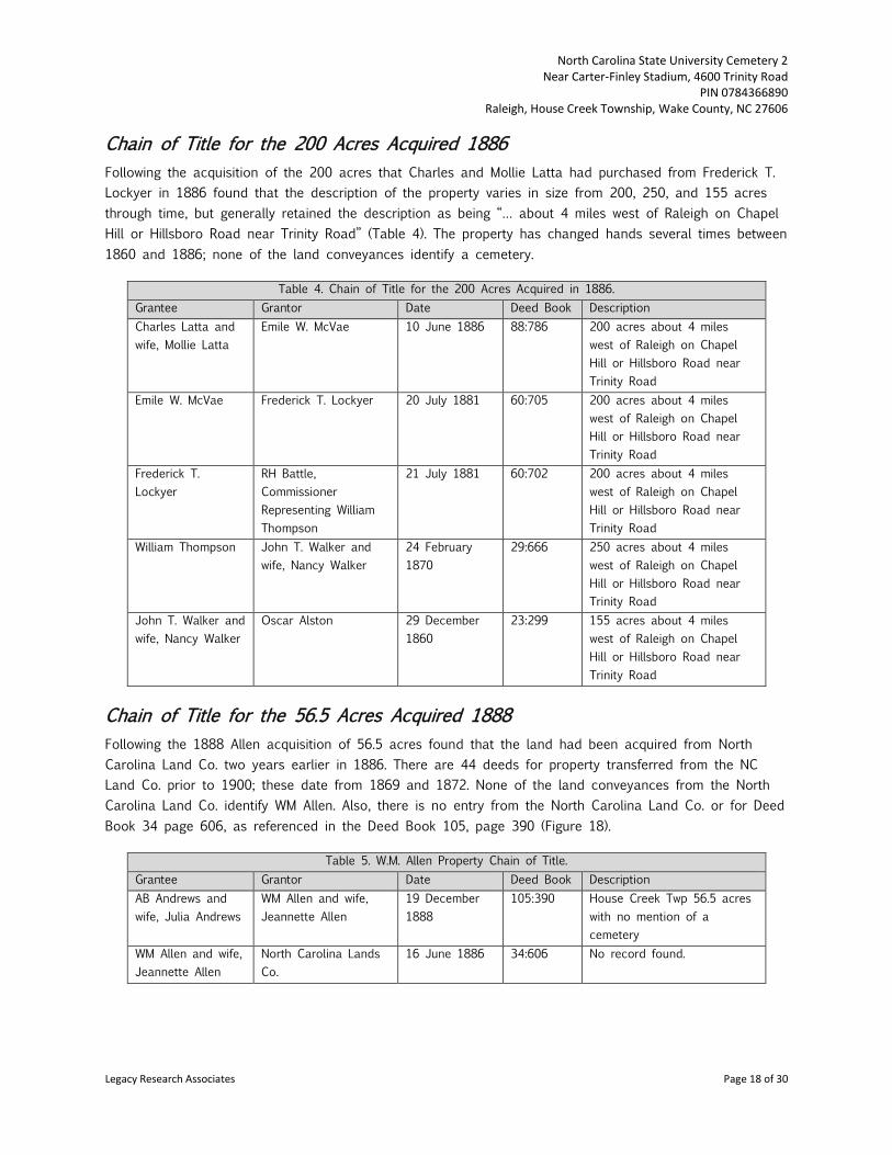
Chain of Title for the 200 Acres Acquired 1886 Following the acquisition of the 200 acres that Charles and Mollie Latta had purchased from Frederick T. Lockyer in 1886 found that the description of the property varies in size from 200, 250, and 155 acres through time, but generally retained the description as being “… about 4 miles west of Raleigh on Chapel Hill or Hillsboro Road near Trinity Road” (Table 4). The property has changed hands several times between 1860 and 1886; none of the land conveyances identify a cemetery.
Table 4. Chain of Title for the 200 Acres Acquired in 1886. Grantee Grantor Date Deed Book Description Charles Latta and wife, Mollie Latta
Emile W. McVae 10 June 1886 88:786 200 acres about 4 miles west of Raleigh on Chapel Hill or Hillsboro Road near Trinity Road
Emile W. McVae Frederick T. Lockyer 20 July 1881 60:705 200 acres about 4 miles west of Raleigh on Chapel Hill or Hillsboro Road near Trinity Road
Frederick T. Lockyer
RH Battle, Commissioner Representing William Thompson
21 July 1881 60:702 200 acres about 4 miles west of Raleigh on Chapel Hill or Hillsboro Road near Trinity Road
William Thompson John T. Walker and wife, Nancy Walker
24 February 1870
29:666 250 acres about 4 miles west of Raleigh on Chapel Hill or Hillsboro Road near Trinity Road
John T. Walker and wife, Nancy Walker
Oscar Alston 29 December 1860
23:299 155 acres about 4 miles west of Raleigh on Chapel Hill or Hillsboro Road near Trinity Road
Chain of Title for the 56.5 Acres Acquired 1888 Following the 1888 Allen acquisition of 56.5 acres found that the land had been acquired from North Carolina Land Co. two years earlier in 1886. There are 44 deeds for property transferred from the NC Land Co. prior to 1900; these date from 1869 and 1872. None of the land conveyances from the North Carolina Land Co. identify WM Allen. Also, there is no entry from the North Carolina Land Co. or for Deed Book 34 page 606, as referenced in the Deed Book 105, page 390 (Figure 18).
Table 5. W.M. Allen Property Chain of Title. Grantee Grantor Date Deed Book Description AB Andrews and wife, Julia Andrews
WM Allen and wife, Jeannette Allen
19 December 1888
105:390 House Creek Twp 56.5 acres with no mention of a cemetery
WM Allen and wife, Jeannette Allen
North Carolina Lands Co.
16 June 1886 34:606 No record found.
Legacy Research Associates Page 18 of 30

North Carolina State University Cemetery 2 Near Carter-Finley Stadium, 4600 Trinity Road
PIN 0784366890 Raleigh, House Creek Township, Wake County, NC 27606
Figure 18. Excerpt of the 1888 land conveyance from Allen to Andrews (Wake County Deed Book 105, page 390).
Field Investigations Field investigations to locate unmarked burials at Cemetery 2 near Carter-Finley Stadium were conducted on November 4 and 5, 2014, by Deborah Joy and Matthew Gill. Aside from knowing that the unmarked cemetery covered ¼-acre, as indicated on the 1938 map (see Figure 6) no specific area on the hilltop identified the space as a cemetery. No signs, fence lines, posts, or clearly defining gravemarkers were present. The area itself appears to be used as a walk-through to the stadium, or occasionally as a gathering spot judging by the crisscrossing paths and scattered litter (Figure 19).
The north and northwest slopes are fairly steep and have many large pine trees, as well as a few small dogwood trees, and small evergreen trees. One large oak tree is on the western side of the landform overlooking Carter-Finley Stadium. The east side of the woodland slopes gently toward the parking area and is covered with large pine trees and one large oak tree. The south, southwest, and west slopes are very steep.
The woodland area has very little ground cover except for a patch of English ivy near Grave 2 and three clumps of yucca.
The investigation consisted of a systematic and selective visual reconnaissance and subsurface investigations to determine the cemetery boundaries based on grave distribution. While the field methods used are a reasonable and prudent effort and meet or exceed present professional standards for cemetery studies. The only method to guarantee locating every burial in a cemetery requires complete excavation, which is beyond the scope of this present survey.
Initial investigation consisted of a clearing vegetation to provide a more detailed visual inspection of the hilltop attempting to determine if any head or footstones were present while also assessing the ground surface for depressions that may indicate the presence of previous soil disturbance. No obvious headstones were identified in this initial assessment although one quartz rock was identified on the ground surface and appeared unusual based on the paucity of other surface stones. This stone was related to a soil anomaly and could be a footstone associated with a grave (Grave 4). One circular depression was identified in the western area of the landform and was flagged as a potential grave (Grave 3).
Following a visual examination of the ground surface, a subsurface exploration was initiated that included the use of a metal ground-penetrating T-bar probe to assess soil compaction and thereby identify areas that may have been previously excavated for graves. Locations that were noticeably different from undisturbed soils, that is, where the T-bar sank into the ground with less effort than in areas that felt
Legacy Research Associates Page 19 of 30

North Carolina State University Cemetery 2 Near Carter-Finley Stadium, 4600 Trinity Road
PIN 0784366890 Raleigh, House Creek Township, Wake County, NC 27606
more compact, were identified as “potential gravesites,” flagged at each end, and sequentially numbered as they were encountered during the field investigation. Most of the probes encountered very compact soil in the upper 1-2 feet and then impenetrable compact clay subsoil. At five locations within the woodland the probing was able to easily pass through the upper compact 1-2 feet of soil and the underlying soil, which indicated that it had more than likely been disturbed in the past.
During examination of this unmarked cemetery, five potential burial locations were identified (Figures 19-20). In addition, several plantings found in the wooded area are consistent with historic vegetation found in North Carolina Piedmont region cemeteries. These include English ivy and yucca plants. The graves are oriented east-west and vary in length from 4.5 to 6 feet. Grave 2 had a small area with English ivy nearby (Figure 21). Grave 3 had a sunken area in the approximate center; within the sunken area was an amorphous chunk of concrete (Figure 22 and Figure 23). Grave 4 has a possible footstone that is a large piece of white quartz (Figure 24).
While five possible grave locations were identified during this investigation that number could be increased many times over if a full excavation of the area was to occur. Soil consistency and compaction in the area made subsurface probing difficult. Prior to full excavation of the ¼-acre, it may be prudent to conduct systematic mechanical excavation of parallel trenches to assess soil profiles and gain better insight and perhaps provide a more accurate grave count.
Legacy Research Associates Page 20 of 30

North Carolina State University Cemetery 2 Near Carter-Finley Stadium, 4600 Trinity Road
PIN 0784366890 Raleigh, House Creek Township, Wake County, NC 27606
Figure 19. Cemetery 2, showing the general extent of the possible burials identified on a contemporary aerial photograph of Carter-Finley Stadium near Gate 6 (Wake County iMAPS).
Legacy Research Associates Page 21 of 30

North Carolina State University Cemetery 2 Near Carter-Finley Stadium, 4600 Trinity Road
PIN 0784366890 Raleigh, House Creek Township, Wake County, NC 27606
Figure 20. Cemetery 2 (Site 31WA1927**), plan map.
.
Legacy Research Associates Page 22 of 30

North Carolina State University Cemetery 2 Near Carter-Finley Stadium, 4600 Trinity Road
PIN 0784366890 Raleigh, House Creek Township, Wake County, NC 27606
Figure 21. Cemetery 2 surface conditions and a potential Grave 2, view southeast toward the parking lot.
Figure 22. Cemetery 2 surface conditions and potential graves (pin flagged) with a quartz rock footstone at Grave 4, view east toward
the RV parking lot.
Legacy Research Associates Page 23 of 34

North Carolina State University Cemetery 2 Near Carter-Finley Stadium, 4600 Trinity Road
PIN 0784366890 Raleigh, House Creek Township, Wake County, NC 27606
Figure 23. Grave 3 depression area with concrete mass, view west.
Figure 24. Close-up of Grave 4 with a quartz chunk that is a possible footstone.
Legacy Research Associates Page 24 of 30

North Carolina State University Cemetery 2 Near Carter-Finley Stadium, 4600 Trinity Road
PIN 0784366890 Raleigh, House Creek Township, Wake County, NC 27606
Next of Kin Advertising Efforts
A legal notice of the intention to remove and reinter the graves at the unmarked cemetery was published in the Raleigh News & Observer on March 27, April 3, 10, and 17 of 2015 (Figure 25). The advertisement was published in fulfillment of Section 65-106 of the General Statues of North Carolina and in an attempt to notify descendants and other interested parties. No response was received.
Figure 25. Affidavit of Publication.
Legacy Research Associates Page 25 of 34

North Carolina State University Cemetery 2 Near Carter-Finley Stadium, 4600 Trinity Road
PIN 0784366890 Raleigh, House Creek Township, Wake County, NC 27606
Summary of Investigations The historical research found a record of the ½-acre graveyard in deeds that date back to 1910 when Everitt Davis sold WB and MS Jones Lot 5 of the division of the WL Davis land that specifically states that it does not include the ½-acre cemetery. It is not stated who retained ownership of the cemetery. The cemetery was not recorded in the late 1930s during the WPA Cemetery Survey and it is not included in the North Carolina Cemetery Census. Historic maps from 1871 to 1914 were examined for evidence of a cemetery. Only the 1914 map indicates a cemetery in the vicinity of present-day Carter-Finley Stadium, but it appears to be Cemetery 1. Historic aerial photographs from 1938 to 1971 show Cemetery 2, as well as Cemetery 1 and the Lincolnville AME Church Cemetery.
It appears that the cemetery dates to around 1910, although who has been buried there is unknown. Given the lack of any engraved tombstones, no genealogy research could be conducted in order to identify any living next of kin. There does not appear to be anything certain that can link the graves to any specific previous owner, although the purchase of the ½ acre lot seems to represent a purchase for a specific use, perhaps for a family cemetery perhaps for the Holderfield family who acquired the property in 1902 or the Davis family, who acquired it in 1904. No next-of-kin have been identified from deed research or genealogical research, which was limited by the absence of marked gravestones. At present, there is no evidence that the cemetery is maintained as a family burial ground.
Field investigations resulted in identifying only five locations that are possible burials. However, the soil is extremely compact in the woodland area and it is not conducive to yielding good results with probing. There was no clear evidence of gravemarkings, although Grave 3 has a possible depression and Grave 4 has a possible footstone (white quartz rock). Other evidence that the property has been used as a cemetery includes English ivy, and yucca plants. Although the archaeological investigations only identified five locations that are possible graves, given the size of the woodland it is very likely that more graves are present.
Legacy Research Associates Page 26 of 30

North Carolina State University Cemetery 2 Near Carter-Finley Stadium, 4600 Trinity Road
PIN 0784366890 Raleigh, House Creek Township, Wake County, NC 27606
Significance Evaluation Individual and collective burial places can reflect and represent in important ways the cultural values and practices of the past that help instruct us about who we are as a people. Yet for profoundly personal reasons, familial and cultural descendants of the interred often view graves and cemeteries with a sense of reverence and devout sentiment that can overshadow objective evaluation. Therefore, cemeteries and graves are among those properties that ordinarily are not considered eligible for inclusion in the National Register of Historic Places unless they meet special requirements. The National Register Criteria for Evaluation include considerations by which burial places may be eligible for inclusion in the National Register (US Department of Interior, National Park Service, 1992).
Four general significance criteria are used to determine eligibility of a property for inclusion in the National Register. Properties may be considered eligible for inclusion if they:
a) are associated with events that have made a significant contribution to the broad pattern of our history;
b) are associated with the lives of persons significant in our past;
c) embody the distinctive characteristics of a type, period, or method of construction; or represent the work of a master, or possess high artistic values, or represent a significant and distinguishable entity whose components lack individual distinction;
d) have yielded or may be likely to yield information important to our understanding of prehistory or history.
Carter-Finley Cemetery 2 is not eligible for inclusion in the National Register of Historic Places under criterion a, as it is not associated with events that have made a significant contribution to the broad patterns of our history. There is no suggestion that it is associated with the lives of persons significant to our past; therefore, criterion b does not apply. Criterion c evaluation finds that this cemetery does not represent the work of a master and it does not have high artistic values. Although it does embody distinctive characteristics of a type, namely the Southern Folk Cemetery, it is not so unusual as to qualify for the National Register. Under criterion d, there is a small likelihood for bone preservation sufficient for physical analysis; therefore, the cemetery is unlikely to yield information important to our understanding of the history or prehistory of the region.
Reinterment Site The proposed plan is to relocate the burials and historic gravesite markers at NCSU Cemetery 2 to the Oakwood Cemetery in Raleigh. This cemetery is located at 701 Oakwood Avenue; Parcel Identification Number 1714110503. This option provides complete use of the property, eliminates security and maintenance issues, and places the graves in an area that will receive perpetual care.
Legacy Research Associates Page 27 of 30

North Carolina State University Cemetery 2 Near Carter-Finley Stadium, 4600 Trinity Road
PIN 0784366890 Raleigh, House Creek Township, Wake County, NC 27606
References Cited Bevers, Fendol 1871 Map of Wake County, NC (Reference URL: http://dc.lib.unc.edu/cdm/ref/collection/ncmaps/id/241). Cawthorn, Joel W. 1970 Soil Survey of Wake County, North Carolina. U.S. Department of Agriculture, Soil Conservation
Service, North Carolina Agricultural Experiment Station. Clauser, John W. Jr. 1984 “The Southern Folk Cemetery in Piedmont North Carolina.” North Carolina Historic Preservation Office Newsletter.
Clements, W. G. 1904 School Map of Wake County, NC (Reference URL: http://dc.lib.unc.edu/cdm/ref/collection/ncmaps/id/281). Daniels, Dennis F. 2001 History of the Polk Prison Property, Blue Ridge Road. Prepared for the North Carolina Department of Cultural Resources. Accessed online at http://www.raleighnc.gov/content/PlanUrbanDesign/Documents/BlueRidge/StateArchivesBlueRidgeHistory.pdf.
Jordan, Terry G. 1982 Texas Graveyards: A Cultural Legacy. University of Texas Press, Austin.
Olds, Fred A. 1919 “Birth and Death of a Camp: Armistice Puts an End to the Feverish War Activity of Camp Polk at Raleigh.” Orphans' Friend and Masonic Journal, Vol. 43, no. 43 (Jan. 17, 1919). Accessed online at http://docsouth.unc.edu/wwi/olds/olds.html.
O’Neal, Michael Keith 2013a Burial Identification at the Lincolnville AME Church Cemetery, Carter-Finley Stadium Parking Lot, North Carolina State University, Raleigh, NC. 2013b Burial Identification at the Carter-Finley Stadium Cemetery 1, North Carolina State University, Raleigh, NC.
Shaeffer, A. Webster 1887 Map of Wake County, NC (Reference URL: http://dc.lib.unc.edu/cdm/ref/collection/ncmaps/id/968) Spoon, W. L. 1911 Map of Wake County, NC (Reference URL: http://dc.lib.unc.edu/cdm/ref/collection/ncmaps/id/419).
Legacy Research Associates Page 28 of 30

North Carolina State University Cemetery 2 Near Carter-Finley Stadium, 4600 Trinity Road
PIN 0784366890 Raleigh, House Creek Township, Wake County, NC 27606
US Department of Agriculture 1914 Wake County Soil Survey (Reference URL: http://www2.lib.unc.edu/dc/ncmaps/interactive/MC_099_1914b.html US Department of Interior, National Park Service 1992 National Register Bulletin 41: Guideline for Evaluating and Registering Cemeteries and Burial Places. Prepared by Elisabeth Walton Potter and Beth M. Boland. http://www.nps.gov/nr/publications/bulletins/nrb41/nrb41_4.htm
University of North Carolina – North Carolina Maps 1971 Aerial photograph of Carter Stadium (Source: http://www2.lib.unc.edu/reference/gis/USDA/wake_1971/index.html 1959 Aerial photograph of Carter Stadium (Source: http://www2.lib.unc.edu/reference/gis/USDA/wake_1959/index.html 1938 Aerial photograph of Carter Stadium (Source: http://www2.lib.unc.edu/reference/gis/USDA/wake_1938/index.html Vlach, John Michael 1978 The Afro-American Tradition in Decorative Arts. University of Georgia Press.
Wake County Register of Deeds Plat Books 1938 Camp Polk property map (Wake County Plat Book 1938, page 5 Deed Books
1920 Chamberlain to State’s Prison (Deed Book 350:540). 1912 Jones to Chamberlain (Deed Book 268:570). 1910 Davis to Jones (Deed Book 248:132). 1904 Holderfield to Davis (Deed Book 187:371). 1902 Alexander to Holderfield (Deed Book 187:372). 1888a Allen to Andrews (Deed Book 105:390). 1886 Latta to Andrews (Deed Book 89:767). 1886 McVae to Latte (Deed Book 88:786). 1881a Lockyer to McVae (Deed Book 60:705). 1881b Battle to Lockyer (Deed Book 60:702). 1870 Walker to Thompson (Deed Book 29:666). 1860 Alston to Walker (Deed Book 23:299).
Legacy Research Associates Page 29 of 30

North Carolina State University Cemetery 2 Near Carter-Finley Stadium, 4600 Trinity Road
PIN 0784366890 Raleigh, House Creek Township, Wake County, NC 27606
APPENDIX A – THE NORTH CAROLINA CEMETERY SURVEY The North Carolina Cemetery Survey is a program for recording vital statistics from the state's cemeteries. It operates at the county level and is coordinated through the State Archives at the state level. The program's objectives are:
1. Identifying, mapping, and describing existing cemeteries in North Carolina regardless of size, type, or physical characteristics. Since vital statistics were not kept officially until 1913, the emphasis of the survey is on those graveyards with burials before that date.
2. Permanently preserving historical, genealogical, sociological, demographic, and cultural data contained in abandoned or otherwise not-cared for cemeteries, including epitaphs and photographs whenever possible.
3. Providing more recent and comprehensive survey data than that available in earlier cemetery surveys, such as the one conducted by the Works Progress Administration (WPA) in the 1930s and 1940s.
RATIONALE
There has been a growing concern about the plight of the forgotten cemeteries that dot North Carolina's landscape. This concern resulted in the formation in 1978 of a legislative study committee (the Abandoned Cemeteries Study Committee) to look into the conditions of abandoned graveyards and to offer recommendations for their protection and preservation.
To assess these conditions, the North Carolina Department of Cultural Resources coordinated an effort using private individuals and organizations to locate and record cemetery data at the county level. The findings of that assessment were reported to the General Assembly in 1981. As a result, the information-gathering program has continued as the North Carolina Cemetery Survey, and the state's criminal and civil statutes pertaining to burial sites have been strengthened. They protect abandoned public graveyards from the threats posed by urban development, agricultural activity, lumbering operations, vandalism, and neglect.
NORTH CAROLINA STATUTES THAT PROTECT CEMETERIES
G.S. 14-148 and G.S. 14-149 outline the penalties for defacing and desecrating gravesites and for plowing over or covering up graves: Violation is a misdemeanor and a Class I felony respectively. The fine is up to $500, and imprisonment is between sixty days and a year. Both penalties may result.
G.S. 70-29 through G.S. 70-33 give the procedure for notifying the proper authorities upon the discovery of unmarked remains: Anyone who discovers unmarked burials, or suspects that they are being disturbed, must notify the county medical examiner or the state archaeologist immediately. There is then a period of forty-eight hours to make arrangements for the protection or removal of the graves. The North Carolina Department of Cultural Resources may obtain administrative inspection warrants for the purpose of gathering additional information as necessary.
Legacy Research Associates Page 30 of 30