carolina thread trail master plan for stanly county ... · carolina thread trail master plan. for...
TRANSCRIPT
1
c a rol in a t hr e a d t r a ilm a s t er pl a n
f or s ta n ly c ou n t y c om m u n i t i e s
adopted august 2010

2
3

4
5
Acknowledgements.................................................................................................................................................. 6Executive Summary ................................................................................................................................................. 9Chapter ¡. Introduction ........................................................................................................................................... 13Chapter 2. Greenway Benefits .................................................................................................................................. 15Chapter 3. Existing Conditions ................................................................................................................................ 19Chapter 4. Stakeholder And Public Outreach ............................................................................................................ 27Chapter 5. Greenway Master Plan Trail Routes ..........................................................................................................39Chapter 6. Recommended Actions For Implementation .............................................................................................53Chapter 7. Conclusion ............................................................................................................................................. 61Appendix I: Design Guidelines ................................................................................................................................63Appendix II: Maintenance and Management ...........................................................................................................101Appendix IIII: Overview of Funding Options .......................................................................................................... 103Appendix IV: Stakeholder And Focus Group Participants .........................................................................................119Footnotes ............................................................................................................................................................. 149
t a bl e of c on t e n t s
6
ack no w l e d ge m e n t s
Stanly County Comprehensive Recreation Plan Committee (SCCRP)
Toby ThorpeDirector, Albemarle Parks & Recreation Department, Chair
Ben DavisStanly County Schools/Albemarle resident
Floyd Wayne CarterPublic Works/Property Maintenance Supervisor, Badin
Dan SullivanPark & Recreation Director, Locust
Mike RiemannVillage of Misenheimer, Council Member
Dan PhillipsTown Council, New London
Buster ThompsonTown Council, Norwood
Larry BranchTown Administrator, Oakboro
Alan SmithOakboro
Kelly BrattainTown Council, Red Cross
Terry AlmondTown Council, Richfield
Bob HarveyTown Administrator, Stanfield
Kelly DombrowskiStanly County Schools
Lindsey DunevantCounty Commission & NCRRS
Travis MoreheadCommunity Coordinator, Carolina Thread Trail
The following organizations signed resolutions of support at the outset of this effort to work with neighboring
communities and with the Carolina Thread Trail to plan, design, and build trails that will connect our communities:
Town of Stanfield
City of Albemarle
Albemarle Downtown Development Corporation
Stanly County Schools
West Stanly Rotary International
Stanly County Chamber of Commerce
Stanly County Convention & Visitors Bureau
Town of Badin
City of Locust
Albemarle Rotary Club
Town of Norwood
Town of New London
Village of Misenheimer
Town of Oakboro
Town of Richfield
Stanly County Board of County Commissioners

7
Carolina Thread Trail Subcommittee
Ron BryantResident/landowner, Norwood
Nancy BryantResident/landowner, Norwood
Danny BurrisBoy Scouts of America, Locust
Billy McRaeProgram Supervisor,
Parks & Recreation Department, Albemarle
Ron CrawleyVice Chairman, Stanly County Planning Board, New London
Brian BristolOwner, Middle Ring Cycles, Albemarle
Peter AsciuttoUwharrie Running Club, Vac & Dash, Albemarle
Dana StoogenkeRocky River RPO, Albemarle
Brooks BarnhardtRocky River Organization for Preservation and Protection
Toby ThorpeDirector, Albemarle Parks & Recreation Department, Albemarle
Ron AnundsonMorrow Mountain, NCDENR, Albemarle
Beth ThroneburgCentral Park NC, Resident of Albemarle, NC
Consultant Team
Jeff OlsonAlta Planning + Design
John CockAlta Planning + Design
Steve DuhAlta Planning + Design
Randy AndersonAlta Planning + Design
Brian BurchfieldAlta Planning + Design
Maya AgarwalAlta Planning + Design
Anne Bothner-ByAlta Planning + Design
Bob HeuerTrust for Public Land
Amanda HugginsThe Lawrence Group
Tom Harrington, RLAThe Lawrence Group
Dave Malushizky, AIA, LEED APThe Lawrence Group
Bill ClarkURS Corporation
Dr. Ananda MitraMLL
Acknowledgements

8

9
e x e c u t i v e s u m m a r y
In 2008, The Stanly County Board of Commissioners and ten
municipalities in the County passed resolutions in support
of an update to the 1999 Stanly County Comprehensive
Recreation Master Plan for the period of 2010 to 2020.
The overall plan is intended to provide clear, logical, and
precise guidelines for future development and growth of
parks, park facilities, recreation programs and activities,
greenways, and trails throughout the county.
The current updates are arranged into two primary
components: an evaluation of and recommendations for
parks and recreation needs in Stanly County for the 2010-
2020 period; and a Carolina Thread Trail Greenway Master
Plan for Stanly County (referred to as the CTT Master Plan).
The Carolina Thread Trail is a regional network of gre-
enways, trails and conserved lands that will reach approxi-
mately 2.3 million citizens and effectively link people, places,
cities, towns and attractions. The scale of The Thread’s con-
nectivity is unparalleled and is based on certain guiding
principles and core values: Collaboration, Community Self-
Determination, Connectivity, Inclusivity, Leverage, and
Respect for the Land and Respect for the Landowners. The
recommended CTT route for Stanly County includes a total
of 109.2 miles of greenways and trails.
a d op t t h e p l a nAdopting the CTT Master Plan for Stanly County is a
critical step in identifying the County’s trail opportunities
and challenges. Once adopted, the plan will influence
County and municipal policy and decisions regarding
trail development in the County, as well as make the
County eligible for funding by various sources, helping to
ensure that the implementation of the trail moves forward
efficiently and effectively.
bu i l d p u bl ic s u p p or t f or t r a i l i m p l e m e n t a t ionA trail system such as the Carolina Thread Trail will
be most successful when supported by a county-wide
citizens’ group. Ultimately a group, such as a “Friends of
the Carolina Thread Trail” coalition, could work to ensure
that public and political interest in the Carolina Thread
Trail remains high and that the trails are successfully used
and maintained once built.
c om p l e t e t op p r ior i t y se gm e n t sIn light of the extensiveness of the Carolina Thread Trail
network, it is important that Stanly County prioritize
specific routes for development. That prioritization is
based on public support, the importance of the connection,
right-of-way availability, cost and available funding, and
ease of implementation. These criteria established seven
high priority Carolina Thread Trail routes which are
shown in Figure 1 on page 12. Table 12 provides a concise
summary of priority trail routes.
k n i t t o ge t h e r f u n di ng f r om a va r i e t y of s ou rce sA variety of potential funding sources are available to
help pay for the Carolina Thread Trail in Stanly County
including private, local, State, regional, and Federal
funding programs. Weaving the resources of these varying
sources together can assist in leveraging funds received
and meeting match requirements.
Currently, the Catawba Lands Conservancy is leading
a private fundraising effort to fund trail planning, design,
land acquisition, and construction for local governments

10
Based on the Carolina Thread Trail guiding principle of “Community Self-Determination”, the master planning process included citizen input
from all over the county.
Attendees at the public workshop in New London
Public meeting participants in Badin
Public workshop in Red Cross
c om m u n i t y i n p u t

11
A public workshop Public meeting participants in Badin
Participants at the 2nd round of public workshops.
Steering Committee Members Public comments on draft CTT map
c om m u n i t y i n p u t

12
Executive Summary
and communities that plan for and adopt greenway master
plans. Federal funds can be an essential component
of funding larger, more expensive trail projects. Each
category of funding is described in detail in Appendix III.
e va lu a t e l a n d or r igh t of wa y ac qu isi t ion op t ionsLand and right of way acquisition along the proposed
route will weigh heavily in assessing each segment’s
ease of implementation. Negotiations with railroads,
utility companies, municipal governments and agencies,
and private property owners will be required. The
recommended actions for implementation included in
Chapter six of this plan provide a clear guide for pursuing
appropriate options. In particular, land suitable for
a greenway along the Rocky River corridor should be
protected as opportunities arise with willing land owners.
de sign, c ons t ruc t a n d m a i n t a i n t r a i l sThe design, construction, and sustenance of new segments
of the Carolina Thread Trail will provide benchmarks for
progress toward completion of the proposed network.
Stanly County should qualitatively measure its successes
toward achieving the goals of the CTT Master Plan and
establish measurable indicators of advancement.
c onclu sionWith the guiding principles of the CTT Master Plan process
held constant, implementation of the Carolina Thread
Trail in Stanly County will help the region achieve a world-
class recreation and transportation system. Additionally,
it will help to achieve educational, environmental, health,
economic and community advantages.
Figure 1: Top priority trail segments.

13
ch a p t e r ¡ . i n t r oduc t ionc a r ol i n a t h r e a d t r a i l
p u r p o se a n d p l a n obj e c t i v e sThe Stanly County Board of Commissioners, along with the
municipalities of Albemarle, Badin, Locust, Misenheimer,
New London, Norwood, Oakboro, Richfield, Red Cross, and
Stanfield, passed resolutions during 2008 to support the
update of the 1999 Stanly County Comprehensive Recreation
Master Plan to provide a planning tool for the period 2010-
2020. The overall goal of the Plan update is to provide clear,
logical, and precise guidelines for the future development and
growth of parks and facilities, recreation programs and activi-
ties, greenways, and trails throughout the county. Specific Plan
objectives, developed by the project Steering Committee, and
confirmed through the public input process include:
• Enhance and expand local park facilities
• Provide walking and biking facilities and trails
• Use technology and county-wide marketing to increase
participation and access to programs/facilities
• Establish partnerships between communities for
facilities and programs
• Respond to new demands for recreation services
• Expand senior recreation facilities and access
• Provide outlets for youth recreation
The Plan updates and replaces the 1999 Plan, and
is formatted into two parts. The first part evaluates,
assesses, and makes recommendations regarding parks
and recreation needs in Stanly County for the 2010-2020
period. The second part of the Plan is this stand-alone
document entitled Carolina Thread Trail Greenway Master
Plan for Stanly County Communities, hence forth referred to
as the CTT Plan or the CTT Master Plan.
c a r ol i n a t h r e a d t r a i lThe Carolina Thread Trail is a regional network of greenways,
trails and conserved lands that will reach approximately 2.3
million citizens. It will link people, places, cities, towns and
attractions. The Thread will help preserve our natural areas
and will be a place for the exploration of nature, culture,
science and history, for family adventures and celebrations
of friendship. It will be for young, old, athlete and average.
This is a landmark project, and creates a legacy that will give
so much, to so many, for so long.
The scale of The Thread’s connectivity is unparalleled
and is based on certain guiding principles and core
values: Collaboration, Community Self-Determination,
Connectivity, Inclusivity, Leverage, and Respect for the
Land and Respect for the Landowners.
col l a bor ation a nd sel f-deter minationCollaboration and communication among the Stanly County
Communities is almost as important as connectivity. The Master
Plan aims to encourage a collaborative process by which green-
ways are conceived and designed in cooperation with adjoining
communities in such a way that a regional asset is created out of
a series of interrelated local decisions and actions.
c on n e c t i v i t y a n d i nclu si v i t yCreating connections between communities and histor-
ical, cultural and recreational attractions is important. The
Carolina Thread Trail seeks to create a region known for
its “ribbons of green” connecting people to each other and
to their heritage. In offering the vision of greater commu-
nity interaction, the program seeks to build bonds among
The Thread will help preserve our natural areas and will
be a place for the exploration of nature, culture, science
and history, for family adventures and celebrations of
friendship.

14
trails are built by assimilating parcels over time in this
fashion.
Through an inclusive, collaborative process, each
county and the communities within that county decide
where their local trail systems will connect and become
part of The Thread. However, not all local trails and
greenways will become part of the Carolina Thread Trail.
Analogous to our highway systems, The Thread will
develop as a “green interstate” focused on linking local
trails and regionally significant attractions. Other trails
will continue to exist or be planned but may not receive
the Carolina Thread Trail designation. Local trails will
retain their own identities, whether or not they are
designated as part of The Thread.
The look and feel of the Carolina Thread Trail may
vary from community to community and county to county.
Designation as the Carolina Thread Trail will signify that a
particular trail is part of a plan to create an interconnected
system, a plan created by local communities working
together with their neighbors to identify connection
points and to build trails that will grow together over time.
Collaboration and self-determination are principles of the CTT process.
diverse neighborhoods, as well as afford all residents
greater access to our natural surroundings. Through this
Master Plan, these goals are established.
l e v e r ageThe Plan’s success depends upon generating additional
investment of outside capital in our region’s natural
resources. Funding sources of the local, state and federal
level are included in Chapter 5.
r e sp e c t f or t h e l a n d a n d l a n d o w n e r sDuring the planning process, Stanly County communities
determined the location of their preferred segments of The
Thread by considering multiple alternative routes. Portions
of these routes included public lands or property owned
by interested landholders, including developers who may
want to offer this amenity to their neighborhoods. The
broad corridors featured present multiple opportunities,
and adjustments to the route will be incorporated as more
landowners are engaged. Expert trail builders indicate that
Chapter 1. Introduction
15
ch a p t e r 2 . gr e e n wa y be n e f i t s
Implementing the Carolina Thread Trail in Stanly County
will help the region achieve a world-class recreation and
transportation system. Multi-use trail facilities will result
in expanded recreation and mobility options for Stanly
County residents and visitors, especially those who seek to
integrate a healthy lifestyle into their daily activities. Given
the scenic beauty of the area, the trail will also offer impor-
tant recreational opportunities. Benefits can be found in a
number of categories, including: education, environment,
health, economics, and overall community rewards.
e duc a t ionTrails are excellent outdoor classrooms that allow trail users
to learn about the natural environment, develop an appre-
ciation for open spaces, and establish a conservation ethic.
An understanding of one’s natural environment can lead
to future efforts to preserve ecologically important areas.
Trails can also highlight historical and cultural sites and
encourage trail users to learn about the historical signifi-
cance and unique culture heritage of an area.
e n v i r on m e n t a lThe Federal Highway Administration (FHWA) conducted
a case study published in 1993 titled The Environmental
Benefits of Bicycling and Walking in the United States. This
study states that “…bicycle-riding and walking do not
contribute to the environmental damage inherent in
extracting, transporting, processing and burning petro-
leum or other fossil fuels”. The FHWA also reports that
Americans are willing to walk to destinations up to two
miles away and bicycle up to five miles away. Given that
nearly half of all trips taken are for a distance of five miles
or less1, encouraging bicycling and walking as a transpor-
tation option can reduce:
• Fossil fuel use
• CO2 (carbon dioxide), CO (carbon monoxide), NOx
(nitrogen oxides) and VOC (volatile organic compounds)
emissions
• Traffic congestion
• Vehicle miles traveled (VMT)
Connecting homes, schools, parks, downtown and
recreation destinations, along with cultural attractions
with a trail system can encourage local residents to walk
or bike to destinations. People choosing to ride or walk
rather than drive are typically replacing short automobile
trips, which contribute disproportionately high amounts
of pollutant emissions. These emission reductions benefit
all residents, whether they are trails users or not.
h e a l t hAmericans’ lack of physical activity is leading to an increase
in a variety of health conditions including hypertension,
cancer, heart disease, diabetes, and obesity, which will
soon eclipse tobacco as the number one preventable cause
of death in the United States. In 2005, less than half of U.S.
adults meet the Centers for Disease Control/American
College of Sports Medicine recommendations for daily
physical activity levels2.
gr e e n space c on t r i bu t e s t o h e a l t h y p l ace s t h r ough:• Stress reduction
• Air filtration
• Encouragement of physical activity
• Economic enhancement
• Carbon sequestration
16
The Surgeon General’s 1992 report, “Physical Activity
and Health,” determined that physical activity can help
reduce cardiovascular disease, lower the risk of colon
cancer, lower the risk of diabetes, lower the risk of
osteoporosis, reduce the risk of obesity, and relieve
symptoms of depression and anxiety. The report also
contains a 1991 Center for Disease Control study that
shows walking is the most common form of exercise for
44.1 percent of the population over 18 years of age.
Bicycling and walking offer a way to integrate physical
activity into busy schedules, and have been demonstrated
to improve these conditions as well as to contribute to
emotional well-being. Studies show that frequency of trail
use is directly proportional to the distance that one lives
from trail access points, and regular trail users see health
benefits. It logically follows that communities with greater
access to trail systems and recreational opportunities will
have healthier populations.
In addition to individual health benefits, physical
activity provides fiscal rewards to the entire community
with a reduction in health care costs and lost days of work.
The studies reviewed report an average annual per capita
health cost savings of $128.3
e c onom icAn integrated and consistent trail system can result in
significant economic benefits to the region. The types of
economic benefits include: increased property values,
tourism revenue, increased consumer spending, local
business expansion, public spending savings and house-
hold savings.
A number of studies show that home prices near
trails are higher than home prices farther away from
trails. Along the Little Miami Scenic Trail in Ohio, an
increased sales price of $7.05 for each foot closer to the
trail was recorded4. This study was conducted in response
to concerns by residents of property value decreases due
to an increase of crime, traffic and noise resulting from
the trail. In 2006, a study analyzed home values in seven
Massachusetts towns near the Minuteman Bikeway and
Nashua River Rail Trail. Homes near the trails sold at
99.3 percent of the listing price, compared to 98.1 percent
for other homes in these towns. Additionally, homes near
the trails sold in an average of 20 days faster compared to
other homes5.
Bicycle-related tourism has been shown to bring
in significant revenue to a region. Studies of bicycle
tourism in Colorado, Maine and the Outer Banks Region
of North Carolina estimate annual bicycle tourism
Chapter 2. Greenway Benefits
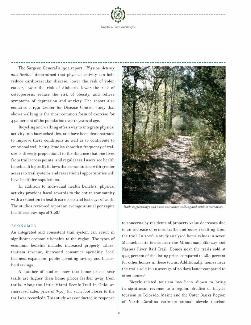
Trails in greenways and parks encourage walking and outdoor recreation.
17
Chapter 2. Greenway Benefits
revenues ranging from $15 million to $193 million in 1999
dollars6, 7, 8.
Bicycle and pedestrian facilities can also lead to
increased spending by consumers. A 1991 National Park
Service study found that long rural trails generated more
revenue per person than shorter urban trails. The study
estimated average expenditures of rail-trail users at $1.90
per person to $14.88 per person9.
A high-quality bicycling environment can bring
bicycle-related businesses to the region. Portland, Oregon’s
bicycle industry was worth approximately $90 million
in 2009, and a study of the economic impact of bicycling
in Colorado found that manufacturing contributes
$763 million and retail sales and service contribute up to
$193 million10, 6.
Bicycle and pedestrian infrastructure saves public
dollars as well. A lane of roadway will accommodate five to
ten times more pedestrian and bicycle traffic than driving
and the cost of bicycling and pedestrian infrastructure is
just a small fraction of that of building highways. Trails
and paths can also be efficient connections to transit,
reducing the need for expensive and land-gobbling park-
and-ride stations.
Household savings can be found by utilizing non-
motorized transportation. Transportation is second to
housing as a proportion of household budgets. Between
2002 and 2008, fuel costs rose from 3% of household
expenditures to 8.5%. Walking and/or bicycling can
help the community shave transportation expenses from
their budgets.
c om m u n i t yThe extent of bicycling and walking in a community has
been described as a barometer of how well that community
is advancing its citizens’ quality of life. Areas that are busy
with bicyclists and walkers are considered to be environ-
ments that work at a human scale, and foster a heightened
sense of neighborhood and community. These benefits are
impossible to quantify, but when asked to identify civic
places that they are most proud of, residents will most often
name places where walking and bicycling are common,
such as a popular greenway, a river front project, a neigh-
borhood market, Main Street, or downtown.
Walking and bicycling are also good choices for
families. A bicycle enables a young person to explore her
neighborhood, visit places without being driven by his
parents, and experience the freedom of personal decision-
making. More trips by bicycle and on foot mean fewer trips
by car. In turn, this means less traffic congestion in the
community. There are also more opportunities to speak
to neighbors and more “eyes on the street” to discourage
crime and violence. It is no accident that communities with
low crime rates and high levels of walking and bicycling
are generally attractive and friendly places to live.
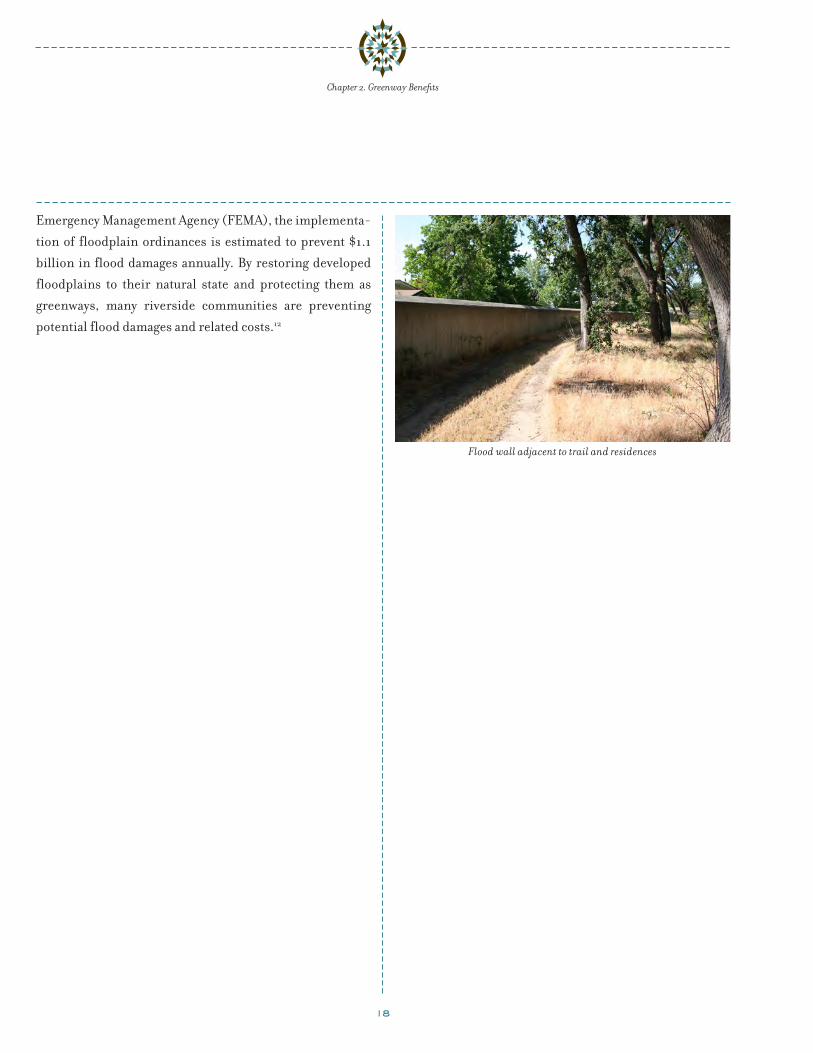
p r o t e c t i ng p e op l e a n d p r op e r t y f r om f l o od d a m age The protection of open spaces associated with trail and
greenway development often also protects natural flood-
plains along rivers and streams. According to the Federal
A comparison of GIS and medical record data show a
positive correlation between urban nature and health,
including:
• Respiratory disease
• Cardiovascular disease
• Mental health
• Musculoskeletal Pain
• Neurological disease
• Digestive complaints
(Mass et al, 2009)11
18
Chapter 2. Greenway Benefits
Emergency Management Agency (FEMA), the implementa-
tion of floodplain ordinances is estimated to prevent $1.1
billion in flood damages annually. By restoring developed
floodplains to their natural state and protecting them as
greenways, many riverside communities are preventing
potential flood damages and related costs.12
Flood wall adjacent to trail and residences

19
ch a p t e r 3. e x is t i ng c on di t ions
geogr a phy of the study a re a /l a nd cov erStanly County encompasses 399 square miles (255,360
acres) and is situated between the Blue Ridge Mountains and
the Coastal Plain. Stanly County is located 42 miles north-
east of Charlotte, North Carolina and 115 miles southwest
of Raleigh, North Carolina. There are nine incorporated
communities in the County: Badin, Locust, Misenheimer,
New London, Norwood, Oakboro, Red Cross, Richfield and
Stanfield. Albemarle, the County seat, is the most populous
area of the County. Overall, the County retains a rural flavor
that defines central North Carolina.
Stanly County is in the Piedmont region, which
includes a portion of the ancient Uwharrie Mountain range.
Flat terrain and gentle rolling hills typify the County’s
topography, with a land cover of forests, agricultural land
and surface water. Slopes within the County are generally
under ten percent. Sedimentary and volcanic rocks underlie
the soils, which support 89,048 acres of forest land and
104,517 acres of farmland. Farmlands are concentrated
primarily in the western and southern portion of Stanly
County. Man-made lakes (reservoirs) include, Tuckertown,
Narrows, Falls and Tillery. Reservoirs and the Yadkin-
Pee Dee River form the eastern boundary of the County.
The Rocky River demarks the southern County boundary.
Surface water covers about 6,638 acres of the County.
p op u l a t ionStanly County’s population has grown approximately 15%
over the past 20 years from a population of 51,765 in 1990 to
59,714 in 2008. While this growth rate is robust, the county,
on average, has grown only half as fast as that of the State of
North Carolina as a whole. Most notably, the pace of growth in
Stanly County had tapered to an annual rate of 0.3% between
2000 and 2008, compared to 1.8% annually for the state.
Table 1. Population Change: Stanly County & North Carolina State (1990-2008)
Jurisdiction 1990 2000 2008Stanly Count y 51,765 58,100 59,714
Percent change (‘90-’00) +12.2%
Percent change (‘00-’08) +2.8%
North Carolina 6,628,637 8,049,313 9,222,414
Percent change (‘90-’00) +21.4%
Percent change (‘00-’08) +14.6%
The North Carolina Office of State Budget and
Management produces population forecasts for counties
extending out to 2029. Using certified, state-based
population estimates for Stanly County and interpolating
between the forecasted population data points, the
following chart illustrates the potential population
forecast for Stanly County. Continued growth is expected
for Stanly County with an estimated 2029 population of
approximately 67,450.
Figure 2. Stanly County Population Forecast (2000-2029)
70,000
67,500
65,000
62,500
60,000
57,500
55,000
52,500
2000
2002
2004
2006
2008
2010
2012
2014
2016
2018
2020
2022
2024
2026
2028

20
One aspect to overall population change is the
distribution of age groups. The child and youth/teen age
groups within Stanly County, which include populations
less than 5 years of age and those less than 18 years of age
respectively, indicate slightly smaller populations of youth
and teens as compared to the state average. By 2006, a
larger percentage of Stanly County youth in their late teens
moved into an older age group than that of their peers
across the state. Additionally, the senior population (65
and over) is larger than the state average and is growing
at a faster rate. Between 2000 and 2006, Stanly County’s
senior population increased by 5.6%, which is 3 times faster
than the state experienced (1.7%) for the same period.
These age group distributions show that the County is
slightly older and has fewer children, which in turn may
place special demands on certain recreation facility types
or program options.
Household characteristics, such as size, income and
poverty levels, also provide insight into the community. As
compared to the state figures from the 2000 Census, Stanly
County households have a larger than average household
size, lower than average income and a higher percentage
of persons with disabilities (ages 5 and over). Additionally,
between 2000 and 2006 Stanly County has experienced
increasing family (up 2.4%) and household (up 5%) sizes,
as compared to the state.
Although the County’s population dynamics indicate
an aging cohort, fewer families now are below the poverty
Chapter 3. Existing Conditions
Table 2. Household and Age Group Comparisons
DemographicsStanly County
(2000)Stanly County
(2006 ACS)North Carolina
(2000)North Carolina
(2006 ACS)Population Characteristics
Population 58,100 59,110 8,049,313 9,036,449
Language other than English 4.7% NA 8.0% NA
Hispanic/Latino 2.1% 3.2% 4.7% 7.0%
Persons w/disabilities 11,949 NA 1,540,365 NA
Persons w/disabilities (%) 22.4% NA 21.1% NA
Household Characteristics
Median income $36,898 $44,988 $39,184 $46,107
Families below poverty level 8.1% 6.7% 9.0% 10.8%
Average household size 2.53 2.59 2.49 2.48
Average family size 3 3.15 2.98 3.04
Home ownership rate 76.3% 78.3% 69.4% 68.1%
Age Groups
Median age 36.9 38.8 35.3 36.8
Population under 5 years of age 6.2% 6.2% 6.7% 7.0%
Population under 18 years of age 25.0% 23.4% 24.4% 24.3%
Population over 65 years of age 14.2% 15.0% 12.0% 12.2%
Source: US Census 2000 & American Community Survey 2006; American FactFinder (factfinder.census.gov)
Note: Income figures in 1999 dollars (2000 Census) and in 2008 dollars (ACS)

21
Trails provide opportunities for physical activity and access to open space

22
Chapter 3. Existing Conditions
limit (down 17%) relative to Census 2000 data, and the
County has shown stronger growth in median income
than that of the state average. Additionally, the County had
witnessed an increase in home ownership rates (up 2.6%)
between 2000 and 2006, while statewide declines existed
(down -1.9%).
e c onom yHistorically, Stanly County’s strong agricultural economy
was supported by robust textile and aluminum industries.
Today, at 27.1 percent, the manufacture of non-durable
goods is the largest employment sector of the Stanly County
economy. The next two major employment sectors are retail
trade at 14.5 percent, and the manufacture of durable goods
at 13 percent. In recent years, tourism has emerged as an
important industry.
Protecting the agricultural economy has been
identified by the County and its citizens to be essential
to Stanly County’s future. In light of the importance of
farmland in Stanly County, a Farmland Preservation
Plan was adopted in late 2009 to guide land use policy.
In 2006, the cash receipts from farming activities in
Stanly County were estimated at 66 million dollars, while
only accounting for 2.1 percent of the County workforce.
Farmland is a natural resource and farmland preservation
can impact the economy indirectly. Preserving farmland
can help direct future development to existing population
centers where public infrastructure is available.
Preserving farmland can also preserve a local foodshed,
provide wildlife habitat, support the growth industry of
agritourism, and sustain the small-town atmosphere and
character desired by residents.
de v e l op m e n t t r e n d sStanly County is at the edge of the Charlotte metropolitan
region. Between 1990 and 2000, Stanly County’s popu-
lation has grown more than 20 percent. Growth and
development pressures are impacting the County, partic-
ularly near Locust, Oakboro, Red Cross and Stanfield.
Currently, 74 percent of the County workforce travels less
than 30 minutes to work. It is anticipated that as planned
road improvements are constructed, access between Stanly
County and the Charlotte metropolitan region will become
easier and the number of commuters, and thereby commute
times, will increase. This trend can change the dynamic of
Stanly County, as the County becomes more amenable to a
commuting workforce. Rural sprawl is an outcome of rapid
growth. “Leap-frog” development patterns are beginning
to occur in less developed areas, which can strain public
infrastructure systems.
e x is t i ng pa r k s a n d t r a i l sAbout 2.6 percent of land in Stanly County is covered by
park and recreation facilities. The County currently does
not provide recreation services. All recreation facilities
and programs are offered and maintained by the State,
local municipalities, private and non-profit groups, and
volunteers.
Residents of Stanly County benefit from a variety
of public parks and natural areas, including the Rocky
Photosimulation of a greenway on the Little Long Creek in Albemarle

23
Chapter 3. Existing Conditions
River, the Pee Dee River, and Badin and Tillery Lakes.
There are currently 608 acres of public parkland and
natural areas distributed among 33 municipally-owned
sites. Additionally, a number of other public and private
open spaces exist throughout Stanly County and add to the
county’s recreation resources, including the 4,742 acres at
Morrow Mountain State Park.
Morrow Mountain State Park is the largest public
recreation area in the County, with 32 miles of trails,
including 16 miles of equestrian trails.
Existing trails in Stanly County include a 1.5 mile
multi-use path in Albemarle and a 0.2 mile path in Oakboro
(connecting to an estimated 1.1 mile path within Oakboro
District Park). Morrow Mountain State Park has 30 miles
of hiking and equestrian Trails. The Town of Badin has
adopted a comprehensive pedestrian plan that includes a
proposed 8 mile trail along the Alcoa Loop and a boardwalk
along the shoreline of Badin Lake. Other proposed trail
projects include 12 miles of trails in Norwood and 27 miles
of multi-use paths in Albemarle.
NCDOT has documented 187 miles of bike routes along
existing roads in Stanly County. The City of Albemarle is in
the process of completing a Comprehensive Bicycle Plan.
r e v i e w of o t h e r c om m u n i t y p l a nsIn addition to the 1999 Stanly County Park & Recreation
Master Plan and to supplement public and stakeholder
outreach, other community plans were reviewed for policy
direction and goals as they pertain to the provision and
planning for parks, recreation, and trails in Stanly County.
The development of each plan reviewed below involved
public input and final adoption by the responsible legisla-
tive body.
Stanly County 2002 Land Use Plan
At the time of writing, the 2002 Land Use Plan was being
updated. Below are principles of the Land Use Plan that
pertain to parks and open space:
Principle Number 2Protect farming as an essential element of Stanly County’s future
in terms of culture, economy, and land use.
Principle Number 4Protect Stanly County‘s unique natural and cultural resources.
Principle Number 7The provision of parks, recreation, and open space needs to be an
element of future land use planning in Stanly County.
The 2002 Plan also includes a recommendation for
preserving land for a greenway along the Rocky River:
“The Rocky River Greenway presents a unique
opportunity to link southern Stanly County with a regional
greenway to Cabarrus, Mecklenburg, and Union Counties
and the Charlotte metropolitan area. A multi-purpose
NC138
NC 73
AUSTIN
NC740
MILLINGPO
RT
PLANK
STMARTIN
NC24-27
TITE
NC8
FORK
VALLEY
CANTON
US52
HWYS
NC200
CHAPELBIG
LICK
NC49
SAM
BUSTE
R
RIDGE
ROWLAND
FINK
NC205
ROGERS
RENE
EFO
RD
GOLDHILL
MAIN
HAZARD
SWIFT
RIVER
OLD
AQUADALE
OLD
SALIS
BURY
NC 731
AIRPORT
FINGER
EFIRD
NC 24-27-73
SMITH
DENNIS
SILVER
WHITL
EY
JOY
POLK FORD
TYSON
NC742OAK
GROVE
RIDGECRES
T
CEN
TRAL
KIRK
INDIANMOUND
LOVE
MILL
BRIDGE
SNUGGS
ENDY
FROG POND
FALLS
COTT
ONVILLE
MOUN
TAINCR
EEK
FIVE POINT
FIRST
TALLEY
OLD
DAV
IS
FRICK
COLEYSTORE
WILLIE
BILES
VICK
BARNHARDT
REAP
STRAND
POND
PAULS
CROSSING
BADIN
ELM
HEARNE
MCNE
IL
YOW
OLD
MILL
PENNINGTON
FLINTRIDG
E
LATON
HWY 4
9
ELLE
N
MILLER
HUGH
PAIGE
BOST
SWAR
INGEN
TOM
WEBB
HARDY
PLESSMILL
GENE
THIRD
RED CROSS
EIGHTH
STOKES FERRY
ALON
ZO
BOWERS
ROCKYRIVER
TOWER
RIDEN
HOUR
BYRD
LAMBE
RT
MCSWAIN
GOLD
BRANCH
SHOR
TCUT
BETHEL CHURCH
LOOP
ROCK HOLE
STONYGAP
GADD
IS
MABRY
MT ZION CHURCH
HARW
OOD
HILLTOP
POPLIN
COOPER
MISSIONCH
URCH
HATLEY
GRIFFIN-GREENE
PRINCE
COYLE
FOURTH
HAR
VELL
OLD W
HITNE
Y
HILL-FO
RD
OSCAR
SIDES
LOVE
BALDWIN
NEWSO
ME
MCLE
STER
CARTER
BANKS
SHAN
KLE
OAKRIDGE
CONCORD
BETHLEHEMCH
URCH
CULP
RUSHING
RILEY
STANLY SCHO
OL
GADD
YSFE
RRY
ODELL
NANCE
PARKER
HIGHROCK
HATLEY FARM
GLENMORE
PALESTINE
EUDY
CAR
RIKER
BARBE
E
GURLEY
OAK
HATLEY
-BURRI
S
FIFTH
BEAR CREEKCHURCH
BURLESON
SIXTH
BELL
DUSTY
GUARD
WESTE
RN
HILLS-VIEW
ALDRIDGE
BETHANY
PORTER
WYATT
BARBEESGR
OVE
LEE
RIDER
PICKLER
KENDALLS
CHURCH
MOSS
GEORGE
SNUGGSPAR
K
CAU
DLE
TA
LAKEWOO
D
US52
HWYN
ALLENTON
AREY
ESTH
ER
DAVIS
EARL
MOLLY
KENDALL
RYAN
LA
JD
STONY
SILVER SPRINGS
US52
NORTH
GOLD
LANIER
BOOG
ERHO
LLAR
OLD S
ANDB
AR
OLDCOT
TONVILL
E
DRYE-HILL
DUNLAP
OLDSCH
OOL
ROSS
BURRIS
SOUTHSIDE
DAN
VILLE
BRANCH
HEND
ERSO
N
MIDW
AY
IVY
HINSON
DEESE
CITYLA
KE
LEWIS
JOES
PALM
ERVILLE
JAY
JANA
WEST STANLY
STAT
E
SAW MILL
APRIL
HUBERT
SALISBURY
NINTH
ALPINE
FISHCAM
P
GOODMAN
JONES
BROOKS
LEONARD
REEVES
ISLAND
TEETER
LEDBE
TTER
CHEROKEE
PEEDEE
EDS
OLD CONCORD
WEST
SUNNYBRO
OK
CLE
TE
WOODHURST
BLALOC
K
LOWDER
SPRIN
GDAL
E
STSTE
PHENS
COLLIE
HELM
S
MORGAN
HARTSELL
EDDINS-POPLIN
BERRY
HILL
RICHAR
D-SAN
DY
PINEBLU
FF
HOWAR
D
SHOREFA
RM
FORREST
EURY
ARBOR
RHEA
HONEYCUTT
YADKIN
BRICK
MATH
FRED
SHADYR
EST
SIMPSO
N
TENTHTREECE
HORN
E
CHURCH
RUMMAGEHOBE
LIFE
WINERY
NAN
NY
NEWT
SUBSTATION
REDCRO
SS
KIMREY
LEDBETTER-FORD
BRIDGEPORT
TUCKER
BW
FOX
MAPLE
RANDOM
PINE
CILLE
VELLA
HOOPS
BRICKYARD
JASE
DUTCH
MOONSHINE
JOHNS
LONG
LISA
PECAN
ADAM
HALLIE
WADE
QUAIL RUN
RUSSELL
HUNTERS
CLAUDE
GREEN
E
ASH
ACCESS
IMPE
RIAL
KYLE
SUNSET
LAKE
SPRU
CE
HALF MILE
HILL
COBLE
FAULKNER
PEAC
EFU
L
BURLE
SONHILL
TERCHER
SCOUT
NELLS
PAGE
VONNIE
CREST
RED
BAR
N
MARY
GRAN
T
HILCO
PARK
MOSS SPRINGS
SPRING
MERNER
LONA
RED
AH
TALBERT
LAKE
VILLAGE
GREENVIEW
DELLA
REBA
KNOLLWOOD
GROVES
MANERS
BLAN
CHE
MONZA
SCOTT
DAIS
Y
MARTIN
MILLS
CLYDE
PIED
MON
T
CATFISH
VERNON
STTHO
MAS
BRIDLE
SCENIC
EMERY
DUNN
STOKER
WINDY HIL
L
NADA
FREE
DOM
FAMIL
Y
GRIFFIN-HILL
AMERON
NC 49
COBLE
ELM
MAIN
GOLDHILL
PARK
AUSTIN
CULP
MAIN
MAIN
STANLY UNION ANSON
CABARRUS
ROWAN
MONTGOMERY
DAVIDSON
RICHMOND
RANDOLPH
Legend
Route 6
Route 3
Route 2
Route 1
Un-Assigned Connectors
Stanly CountyBike Routes
Stanly County Bike Route Map

24
Chapter 3. Existing Conditions
greenway is recommended for this corridor, a greenway
that ultimately would link to the Yadkin-Pee Dee River at
Norwood.”
2003 Stanly County Thoroughfare Plan
This plan identifies state and county recommended on-road
bike routes for recreational cyclists.
2005 Albemarle/Stanly County Strategic Economic
Development Plan
The Target Industry Analysis identified five target industries
to stimulate growth in Stanly County: plastics, retirement
and health care services, fabricated metals and machinery,
transportation equipment, and tourism.
2009 City of Albemarle Land Use Plan
Albemarle recently adopted a new comprehensive land
use plan. The planning committee considered bicycle
and pedestrian friendly issues to be a top priority within
numerous categories of the plan, including transportation,
residential development, commercial development, open
space/recreation, downtown development, and commu-
nity appearance. The creation of the greenway system was
repeatedly mentioned as a top strength of the City. The plan
also emphasizes the need for connectivity between parks
and the need to preserve additional open space areas.
2007 Albemarle Comprehensive Pedestrian Plan
Along with identifying, pricing, and ranking 49 miles
of multi-use greenway paths, this transportation plan
Rocky River, Leiby Park (Source: T. Morehead, Carolina Thread Trail)
25
Chapter 3. Existing Conditions
recommended several guidelines and policy changes
related to recreation that would:
• set design guidelines for greenway trails;
• give project priority to pedestrian access to parks;
• incorporate aesthetics and landscaping into transporta-
tion design; and,
• require new development to set aside public green space.
2010 Albemarle Comprehensive Bicycle Plan
Recommendations in this plan will connect 11 miles of
proposed multi-use greenway paths (including recom-
mended routes for the Carolina Thread Trail) with
proposed on-street bike accommodations throughout the
City of Albemarle. In addition, guidelines suggested in the
Plan will help to determine the appropriate type of bicycle
facility on roadways according to their traffic volumes and
speeds. The plan includes recommendations for the acqui-
sition of land for on and off-road paths.
2007 Badin Comprehensive Pedestrian Plan
Recommendations for this plan include numerous walking
and biking paths, trails, and boardwalks connecting down-
town Badin with Badin Lake and the Alcoa Facility, along
with the design guidelines for these amenities. The plan
includes 8 miles of proposed trails as well as additional
mileage of new sidewalks.
2007 Norwood Comprehensive Pedestrian Plan
Recommendations for this plan include pedestrian and
bicycle paths that connect downtown Norwood with Lake
Tillery and Rocky River, along with the design guidelines
for these amenities. The plan includes 12 miles of proposed
trails as well as additional mileage of new sidewalks.
2003 Village of Misenheimer Land Use Plan
Principle # 5 of the Land Use Plan states: “Create public
spaces in which the community can gather and enjoy
recreational opportunities. In order to fulfill our desire to
place recreational facilities at the disposal of our citizens,
we need places where individuals can come together and
enjoy common pursuits. We need parks or similar spaces
in which to gather, exercise, play and compete. These sites
should be varied in size, function, and location in order
to fulfill the assorted tastes of our diverse population. The
Village should seek over time to create more public places
and social gathering places which ought to be scattered in
various neighborhoods throughout the Village.”
2007 Town of Red Cross Zoning Ordinance
In order to develop a system of quality open spaces and
recreation areas throughout the Town of Red Cross, new
developments need to account for a minimum percentage
of open space, depending on their density. Open space
shall include recreational areas, wooded areas, and envi-
ronmental open space. As an alternative to incorporating
required open space on a development site, the devel-
oper has the option of requesting that the town permit
the purchase of another piece of land more suitable to
conservation.
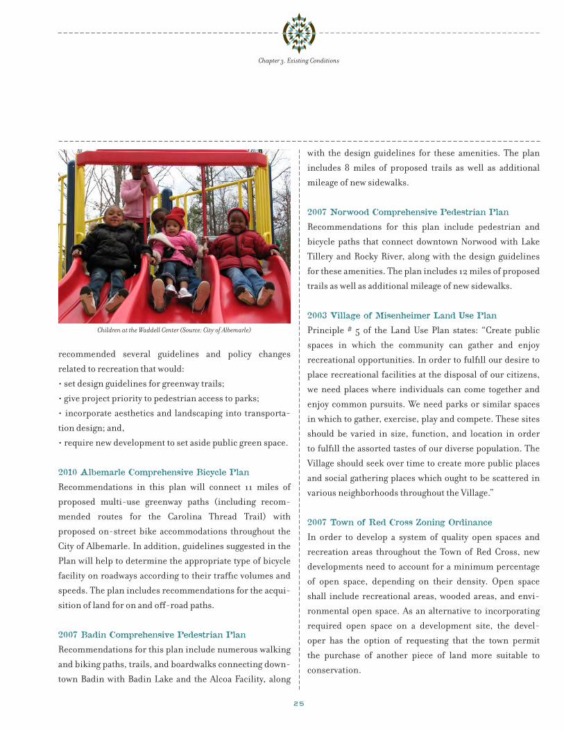
Children at the Waddell Center (Source: City of Albemarle)
26
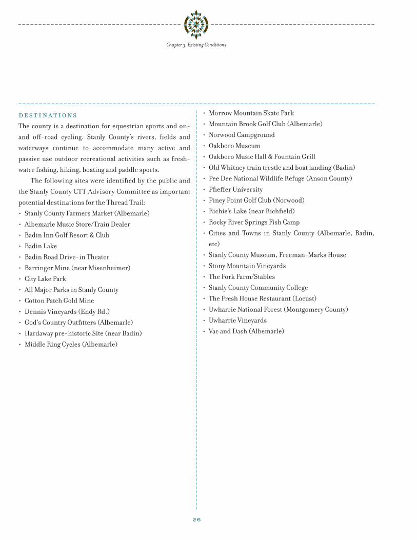
de s t i n a t ionsThe county is a destination for equestrian sports and on-
and off-road cycling. Stanly County’s rivers, fields and
waterways continue to accommodate many active and
passive use outdoor recreational activities such as fresh-
water fishing, hiking, boating and paddle sports.
The following sites were identified by the public and
the Stanly County CTT Advisory Committee as important
potential destinations for the Thread Trail:
• Stanly County Farmers Market (Albemarle)
• Albemarle Music Store/Train Dealer
• Badin Inn Golf Resort & Club
• Badin Lake
• Badin Road Drive-in Theater
• Barringer Mine (near Misenheimer)
• City Lake Park
• All Major Parks in Stanly County
• Cotton Patch Gold Mine
• Dennis Vineyards (Endy Rd.)
• God’s Country Outfitters (Albemarle)
• Hardaway pre-historic Site (near Badin)
• Middle Ring Cycles (Albemarle)
• Morrow Mountain Skate Park
• Mountain Brook Golf Club (Albemarle)
• Norwood Campground
• Oakboro Museum
• Oakboro Music Hall & Fountain Grill
• Old Whitney train trestle and boat landing (Badin)
• Pee Dee National Wildlife Refuge (Anson County)
• Pfieffer University
• Piney Point Golf Club (Norwood)
• Richie’s Lake (near Richfield)
• Rocky River Springs Fish Camp
• Cities and Towns in Stanly County (Albemarle, Badin,
etc)
• Stanly County Museum, Freeman-Marks House
• Stony Mountain Vineyards
• The Fork Farm/Stables
• Stanly County Community College
• The Fresh House Restaurant (Locust)
• Uwharrie National Forest (Montgomery County)
• Uwharrie Vineyards
• Vac and Dash (Albemarle)
Chapter 3. Existing Conditions

27
ch a p t e r 4. s t a k e hol de r a n d p u bl ic ou t r e ach
Citizen and stakeholder input was the cornerstone for
formulating the Carolina Thread Trail and Greenway
Master Plan recommendations. Community and stake-
holder input provided a clear framework for park, trail and
recreation planning that reflected the current priorities
of the community, while looking forward to the next ten
years. Most residents care deeply about the future of Stanly
County’s parks and open space system and appreciated the
opportunity to offer feedback in the development of this
Plan. Public outreach was local and grassroots-oriented,
with varied and extensive methods to involve the commu-
nity, specifically including:
• Creation of the Stanly County Comprehensive Recreation
Plan Steering Committee (SCCRP).
• Creation of a Stanly County Carolina Thread Trail Advisory
Sub-Committee
• Focus groups to develop a needs assessment and public
opinion questionnaire
• Eight Public Workshops held throughout the county
• Administration of a random sample countywide needs
assessment and public opinion survey between October
and December 2009
• Youth-specific survey distributed to schools throughout
the County
Stanly County Comprehensive Recreation Plan Steering
Committee (SCCRP)
Public outreach began with a Steering Committee meeting
in which members from each community in the County were
introduced to the recreation needs assessment process. The
project steering committee was created to assist in completing
the plan. The Stanly County Comprehensive Recreation Plan
Steering Committee (SCCRP) is a steering committee of
agency staff and citizens appointed by County Commissioners
and Municipal Councils. A list of the committee members is
included on page 6 in the acknowledgements section. The
committee provided information, ideas, and feedback during
the planning process, assisted in overcoming obstacles,
represented public, agency and organization interests and
policies, and assisted in building support for the plan process
and recommendations. The members provided ongoing feed-
back during the process to create a master plan which reflects
the real needs of Stanly County.
The steering committee met monthly or bi-monthly
over the course of the process, including five meetings
facilitated by the consultant team. Notes from the steering
committee meetings are contained in Appendix IV.
Stanly County Carolina Thread Trail (CTT) Advisory Sub-
Committee
The participating jurisdictions and SCCRP members estab-
lished a sub-committee of 12 representatives from across
the county and the region to provide oversight and guidance
in the development of the Carolina Thread Trail Plan for
Stanly County. A list of the committee members is included
on page 6 in the acknowledgements section. The committee
was sub-divided into a Technical Advisory Team (TAT) to
provide input on trail alignments and an Outreach Team to
help facilitate public awareness of the plan and process. The
committee met in person and via conference call throughout
the course of the project to establish project goals and objec-
tives and to recommend preliminary alignments for the CTT
based on local knowledge and public input.
The kickoff meeting of the Stanly County Advisory
CTT Sub-Committee was held on September 22, 2009
at the Stanly County Agri-Civic Center near Albemarle.
Below is a categorized list of committee feedback with
suggested overarching goal headings:
28
Chapter 4. Stakeholder and Public Outreach
CTT Advisory Committee Goals
Consider Broader Community Benefits in Trail Development• Healthier lifestyles; opportunities for walking/biking
• Appreciate natural, cultural heritage
• Utilization of farmland for tourism
Promote Trail Connections across County and Within Towns• Make connections: prioritized trails, well connected,
decent distances/length
• Encourage towns to connect to CTT
• Greenways along Rocky River tributaries into nearby
towns
• In-city trails
• Finish what has been started in towns re: greenways/
trails
• Establish/Improve blue trails along water ways
Establish Partnerships in Trail Network Development• Establish working relationships between groups:
railroads, utilities, landowners
• Get in touch with Fork Farms. Fork Farm connections
along Rocky River
Utilize Sensitive Trail Design Details• Pervious trail surfaces
• Keep natural feel; less urban; e.g., limited lighting
• Ready access for emergency responders
• Overnight facilities
• Set up parks at each bridge along the Rocky River for
access to trails
Parks
recreation
trails
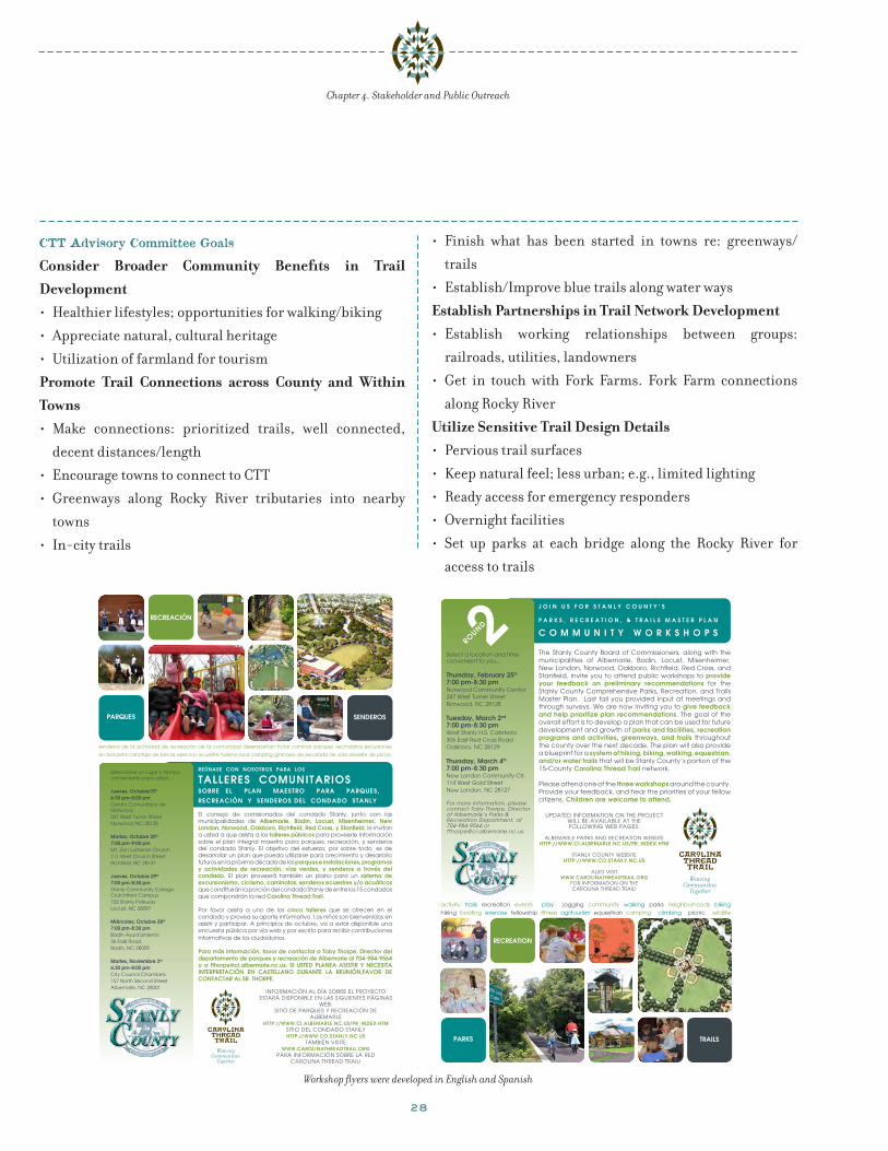
The Stanly County Board of Commissioners, along with the municipalities of Albemarle, Badin, Locust, Misenheimer, New London, Norwood, Oakboro, Richfield, Red Cross, and Stanfield, invite you to attend public workshops to provide your feedback on preliminary recommendations for the Stanly County Comprehensive Parks, Recreation, and Trails Master Plan. Last fall you provided input at meetings and through surveys. We are now inviting you to give feedback and help prioritize plan recommendations. The goal of the overall effort is to develop a plan that can be used for future development and growth of parks and facilities, recreation programs and activities, greenways, and trails throughout the county over the next decade. The plan will also provide a blueprint for a system of hiking, biking, walking, equestrian, and/or water trails that will be Stanly County’s portion of the 15-County carolina thread trail network.
Please attend one of the three workshops around the county. Provide your feedback, and hear the priorities of your fellow citizens. children are welcome to attend.
UPdaTed iNfORMaTiON ON The PROjeCT WiLL be avaiLabLe aT The fOLLOWiNg Web PageS:
aLbeMaRLe PaRkS aNd ReCReaTiON WebSiTe httP://www.ci.albemarle.nc.us/Pr_index.htm
STaNLy COUNTy WebSiTehttP://www.co.stanly.nc.us
aLSO viSiT www.carolinathreadtrail.org
fOR iNfORMaTiON ON The CaROLiNa ThRead TRaiL!
Select a location and time convenient to you...
thursday, February 25th
7:00 pm-8:30 pmNorwood Community Center 247 West Turner StreetNorwood, NC 28128
tuesday, march 2nd 7:00 pm-8:30 pmWest Stanly h.S. Cafeteria 306 east Red Cross RoadOakboro, NC 28129
thursday, march 4th
7:00 pm-8:30 pmNew London Community Ctr.114 West gold Street New London, NC 28127
For more information, please contact Toby Thorpe, Director of Albemarle’s Parks & Recreation Department, at 704-984-9564 or [email protected].
S ounty
j o i n u s F o r s t a n l y c o u n t y ’ s
P a r k s , r e c r e a t i o n , & t r a i l s m a s t e r P l a n
c o m m u n i t y w o r k s h o P s
activity trails recreation events play jogging community walking parks neighborhoods biking hiking boating exercise fellowship fitness agritourism equestrian camping climbing picnic wildlife
2round
reÚnase con nosotros para los
talleres comunitarios soBre el plan maestro para parQues, recreaciÓn y senDeros Del conDaDo stanly
Seleccione un lugar y tiempo conveniente para usted...
jueves, octubre15th
6:30 pm-8:00 pmCentro Comunitario de Norwood247 West Turner StreetNorwood, NC 28128
martes, octubre 20th 7:00 pm-9:00 pmMt. Zion Lutheran Church 111 West Church StreetRichfield, NC 28137
jueves, octubre 29th
7:00 pm-8:30 pmStanly Community College-Crutchfield Campus 102 Stanly ParkwayLocust, NC 28097
miércoles, octubre 28th
7:00 pm-8:30 pmBadin Ayuntamiento36 Falls RoadBadin, NC 28009
martes, noviembre 3rd
6:30 pm-8:00 pmCity Council Chambers 157 North Second StreetAlbemarle, NC 28001
El consejo de comisionados del condado Stanly, junto con las municipalidades de albemarle, Badin, locust, misenheimer, new London, Norwood, Oakboro, Richfield, Red Cross, y Stanfield, le invitan a usted a que asista a los talleres públicos para proveerle información sobre el plan integral maestro para parques, recreación, y senderos del condado Stanly. el objetivo del esfuerzo, por sobre todo, es de desarrollar un plan que pueda utilizarse para crecimiento y desarrollo futuros en la próxima década de los parques e instalaciones, programas y actividades de recreación, vías verdes, y senderos a través del condado. el plan proveerá también un plano para un sistema de excursionismo, ciclismo, caminatas, senderos ecuestres y/o acuáticos que constituirán la porción del condado Stanly de entre los 15 condados que compondrán la red carolina thread trail.
Por favor asista a uno de los cinco talleres que se ofrecen en el condado y provea su aporte informativo. los niños son bienvenidos en asistir y participar. a principios de octubre, va a estar disponible una encuesta pública por vía web y por escrito para recibir contribuciones informativas de los ciudadanos.
para más información, favor de contactar a toby thorpe, Director del departamento de parques y recreación de albemarle al 704-984-9564 o a [email protected]. si usteD planea asistir y necesita interpretaciÓn en castellano Durante la reuniÓn,faVor De contactar al sr. thorpe.
senderos de la actividad de recreación de la comunidad desempeñan trotar caminar parques vecindarios excursiones
en bicicleta canotaje de becas ejercicio ecuestre turismo rural camping gimnasio de escalada de vida silvestre de picnic
parQues
recreaciÓn
senDeros
INFORMaCIóN al día SObRe el PROyeCTO eSTaRá dISPONIble eN laS SIgUIeNTeS PágINaS
web:SITIO de PaRqUeS y ReCReaCIóN de
ALBEMArLE http://www.ci.alBemarle.nc.us/pr_inDex.htm
SITIO del CONdadO STaNly http://www.co.stanly.nc.us
TaMbIéN vISITe www.carolinathreaDtrail.org
PaRa INFORMaCIóN SObRe la Red CaROlINa ThRead TRaIl!
S ounty
Workshop flyers were developed in English and Spanish

29
Chapter 4. Stakeholder and Public Outreach
p u bl ic w or k shop s
First Round Public Workshops
In order to gain further insight into the public’s percep-
tions of the needed parks and recreation facilities in Stanly
County, the SCCRP held two rounds of public workshops for
the Carolina Thread Trail Greenway Master Plan project.
The first series of workshops were held during the fall of
2009 at:
• The Norwood Community Center in Norwood on October
15, 2009
• The Mt. Zion Lutheran Church in Richfield on October
20, 2009
• The Badin Town Hall in Badin on October 28, 2009
• The Stanly Community College, Crutchfield Campus, in
Locust on October 29, 2009
• The City Council Chambers in Albemarle on November 3,
2009
SCCRP members recruited attendance at the workshops
by posting flyers in public places and notices on public
websites. SCCRP also announced the meetings through
e-mail distribution lists and through personal contacts.
Nearly seventy participants attended the fall 2009
public workshops to learn about the project, engage
in group discussions and mapping exercises. These
participants represented a broad spectrum of County
residents, including youth, municipal staff and local
elected officials.
Each workshop began with an introductory
presentation on the Carolina Thread Trail and the park
and recreation planning processes. The presentation was
followed by a facilitated small group discussion on current
issues, future visions and opportunities for enhancing
and expanding park, recreation and trail facilities and
programs. The outcome of each meeting included detailed
recommendations of potential greenway and trail routes.
Public Workshop Comment Summary
The feedback from the first round of public meeting is
summarized as follows:
• Participants indicated that greenways and trails were
important to develop over the next twenty years. Trails
should be developed to link community and area
destinations. Trail planning efforts should be coordinated
with regional trail planning projects
• Trails should accommodate a wide range of users,
including pedestrians, bicyclists, equestrians, and
watercraft users
• Good access to trails (both land and water based trails)
was an important factor. Access included physical access
to trail and designing trails and access points to be ADA
compliant
• A number of trail support facilities, such as, water
fountains, restrooms, lighting, picnic shelters and
signage were listed as desirable. Other support facilities
mentioned were concession stands along long stretches
“Identify the issues…
Build consensus for solutions.”
Attendees at the 2nd round public meeting in Red Cross

30
Chapter 4. Stakeholder and Public Outreach
of trail and bike and water equipment rental facilities
with drop-off and pick-up options
• Design safety into trails and bikeways. Elements such
as lighting, emergency phones were noted as essential
safety features. Exposure to vehicular traffic was noted
as safety issue for non-motorized trail users and outdoor
enthusiasts.
• Preservation of green or open spaces was a meaningful
component of a greenways, blueways and trails plan
• Collaborate with organizers of local events such as “Run
the Loop”, “Run the Valley”, cross country events and
farmer’s markets.
Second Round Public Workshops
In February and March of 2010, the second round
of public meetings took place. These meetings were
conducted in:
• The Norwood Community Center in Norwood on February
25, 2010
• West Stanly High School cafeteria in Oakboro on March 2,
2010
• New London Community Center in New London on
March 4, 2010
Preliminary recommendations, based on the input
from earlier public meetings, were presented to attendees.
These meetings were attended by more than 90 citizens
and stakeholders, including elected officials, youth,
and local business owners and land owners. Many of the
attendees at the second round workshops had not attended
the first round workshops or participated in the prior
public outreach efforts. The attendees came with strong
opinions, especially regarding the potential alignments
of the CTT. This input proved very valuable in refining
the recommended CTT routes and developing the plan
priorities.
The following is a summary of the comments received
during the discussion and question and answer portion of
the public meetings.
• Support for trails in Stanly County:
• Trails and bikeways are among the most important
priorities for future park projects.
• Trails in other states have been very successful.
• Trails alongside roads and in other existing rights-
of-way might be more easily maintainable and more
publicly palatable.
• Preservation:
• The County should preserve land now before it can be
lost to development.
• There was also concern about the preservation of
agricultural lands for use in food production.
• Concerns about trails in Stanly County:
• Consensus that eminent domain should be avoided
for trails in Stanly County.
• Property owners may support trails going across
the frontage of a property but not along the rear of a
property.
• Perception of theft and trespassing along trails in
agricultural areas.
• Trails in areas used for hunting could be a liability.
Participants at the 2nd round public meeting in New London

31
Chapter 4. Stakeholder and Public Outreach
• Trails should not be located on private property
• Trails must be policed and maintained
• Concerns about lack of connectivity.
• Some felt that park and recreation facilities are more
important than trails.
• Trails could be damaging to the environment.
p u bl ic s u r v e y
Needs Assessment and Public Opinion Questionnaire
Focus Groups
Management Learning Laboratories (MLL) and the
consultant team led a series of local focus group meetings
to assist in designing a user needs assessment survey. The
design process included review, input, and pre-testing by
the SCCRP, staff, and other stakeholders. The focus groups
included County and municipal staff, elected officials, and
representatives of various county agencies, recreation orga-
nizations, and user groups (see Appendix IV for a complete
list of focus group participants).
Needs Assessment and Public Opinion Survey and
Report Overview
As a key component of the public input process, MLL
prepared a “comprehensive assessment of the recreation
needs, attitudes and opinions of the residents of the entire
community.” The needs assessment was based on “a statis-
tically viable and reliable random sampling procedure”. The
survey was administered between October and December
2009 through two separate efforts: a random sample survey
mailed to four thousand county households, and a self-
selected survey posted on the Internet.
Random Sample Survey
Due to cost constraints, it was not feasible to survey all
Stanly County residents about their recreational needs,
attitudes and opinions. In order to get survey results that
would reflect the community as a whole, a statistically viable
and reliable random sampling survey method was admin-
istered. Four thousand addresses were randomly selected
from all county addresses to receive the survey. Within
a small margin of error (3% to 5%) the sample is a reli-
able representation of the entire community. Of the 4,000
surveys mailed, 305 (or 8%) of the surveys were returned
and recorded.
Self-Selected Online Survey
The survey was also posted online. The online survey
allowed a group of “self-selected” individuals to have their
comments included in the survey results. Self-selected Priority CTT trail routes identified by second round public meeting participants.

32
individuals choose to participate in the survey and they tend
to be more familiar with the recreational opportunities in
Stanly County. Since familiarity can be a source of bias,
self-selected surveys are not statistically valid, although
they do provide additional insight.
The online survey netted nearly 200 responses.
Generally, the results of the online survey were very
close to the results of the random sample survey. One of
the significant differences between the respondents of
the mailed survey and the online survey was found in
the age group category. Online respondents in the 35
to 44 years age category outpaced the same age group in
the random sample survey response category by 16.9%
(Figure 3). Although, mail survey respondents in the 55 to
64 age category beat the online responders in the same age
category by 12.2%.
As the random sample survey results are unbiased
sampling, the following summary is based on trail and
greenway related answers from the random sample survey
results.
Figure 3. Random Sample Survey and Online Survey Respondent by Age Category
Mailed Survey Online Survey
0%
5%
10%
15%
20%
25%
30%
35%
18-24 25-34 35-44 45-54 55-64 65-69 70-74 Over 75
Table 3. Distribution of adult respondents by location
Do you live in the town/city limits of the following places?
Response Percent
Response Count
Albemarle 47.3% 140
Badin 0.3% 1
Gold Hill 0.3% 1
Kannapolis 0.3% 1
Locust 10.8% 32
Midland 0.3% 1
Mount Pleasant 0.7% 2
New London 6.8% 20
Norwood 12.5% 37
Oakboro 7.4% 22
Richfield 4.7% 14
Stanfield 8.5% 25
Total Responses 296
Skipped Question 8
Chapter 4. Stakeholder and Public Outreach

33
Chapter 4. Stakeholder and Public Outreach
Community Recreation Interest Recommendations
Survey respondents indicated that adventure activities,
special events, passive recreation opportunities, outdoor
fitness opportunities and gardening are the top five recre-
ational interests in Stanly County (see Figure 4.)
Figure 4. Random Sample Survey Respondents Top Recreational Interests
88%
86%
84%
82%
80%
78%
76%
74%
Adventure activity
Special events
Passive recreation
Outdoor fitness
Gardening
87% 87%86%
82%
78%
Personal Opinions Recommendations
Respondents were given the opportunity to evaluate 25
statements and rank them according to importance. The
top five issues are shown in Figure 5.
Figure 5. Personal Opinions of Random Sample Survey Respondents
0%
20%
40%
60%
80%
100%
Well-maintained parks add to the quality of life in the community.
Parks and Recreation is an essential service to the community.
It is important to maintain the existing facilities.
Stanly County needs to emphasize preservation and conservation.
There is a need for activities for the whole family.
97% 94% 93% 90%83%
Areas of Importance
Respondents were given a list of 62 facilities and programs
to consider. Respondents were asked to choose facilities
and programs were important to them and their house-
holds. Respondents were also asked to indicate if they
would support increased funding for the facilities and
programs. The top ten results are listed in Table 4 and are
recommended for implementation as they correlate with
the recreation interests demonstrated by the respondents.
Of the top ten results, many of the facilities or programs
indicated are related to trails and greenways facilities or
activities.
34
Chapter 4. Stakeholder and Public Outreach
Table 4. Top 10 Facilities and Programs Important to Random Sample Survey Respondents
Facility or ProgramImportance
Rating
Support Increased Funding
Natural areas 85% 15%
Walking trails 83% 14%
Picnic shelters 77% 9%
Playgrounds 77% 12%
Special events and festivals 75% 10%
Youth activities 74% 13%
Festivals for arts and crafts 72% 6%
Passive recreation opportunities 70% 7%
Signed bicycle walking routes 70% 9%
Surveillance in the parks *69% 18%
Youth leagues *69% 15%
*Tied for the tenth spot
Online Youth Survey Overview
A youth survey was conducted by the project team to
measure attitudes and interest in parks and recreation
facilities and programs. Respondents could respond to the
survey online or on a printed form. Five hundred and fifty
(550) local youths took the survey, with the largest number
of respondents (229) coming from Gray Stone Day School.
The highest percentage of respondents ranged between 13
years and 15 years in age (36.5%), with the respondents
in the 16 years to 18 years of age category (34.3%), close
behind (see Table 5). Female and male respondents were
nearly evenly split, with 51.8% female respondents and
48.2% male respondents.
Table 5. Youth respondents sorted by age rangeAge Range of Respondents
Response Percent Response Count
6-8 3.6% 20
9-12 25.6% 141
13-15 36.2% 199
16-18 34.0% 187
Unresponsive 0.50% 3
Total Responses 550
The largest percentage of the respondents live within
Albemarle’s boundaries (33.3%), followed closely by
respondents who live in unincorporated Stanly County
(30.5%). Table 6 shows the distribution of respondents by
location.
Table 6. Distribution of youth respondents by location
Do you live in the town/city limits of the following places?
Response Percent
Response Count
Albemarle 33.3% 179
Badin 11.3% 61
Locust 1.3% 7
Misenheimer 1.3% 7
New London 11.5% 62
Norwood 3.0% 16
Oakboro 2.0% 11
Red Cross 0.9% 5
Richfield 4.3% 23
Stanfield 1.7% 9
No, I do not live in any of these town/city limits. 30.5% 164
Total Responses 538
Skipped Question 12
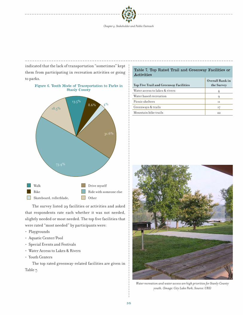
Given that most respondents (73.4%) are not of
driving age, it was indicated that they “ride with someone
else” to get to parks or recreational activities. Figure
6 shows modes of travel used by youth to get to parks in
Stanly County. Nearly half of the respondents (44.2 %)
35
Chapter 4. Stakeholder and Public Outreach
indicated that the lack of transportation “sometimes” kept
them from participating in recreation activities or going
to parks.
Figure 6. Youth Mode of Transportation to Parks inStanly County
Walk
Bike
Skateboard, rollerblade,scooter
Drive myself
Ride with someone else
Other
13.5%8.6%
31.6%
73.4%
18.5%4%
The survey listed 29 facilities or activities and asked
that respondents rate each whether it was not needed,
slightly needed or most needed. The top five facilities that
were rated “most needed” by participants were:
• Playgrounds
• Aquatic Center/Pool
• Special Events and Festivals
• Water Access to Lakes & Rivers
• Youth Centers
The top rated greenway-related facilities are given in
Table 7.
Water recreation and water access are high priorities for Stanly County youth. (Image: City Lake Park, Source: URS)
Table 7. Top Rated Trail and Greenway Facilities or Activities
Top Five Trail and Greenway FacilitiesOverall Rank in
the Survey
Water access to lakes & rivers 4
Water based recreation 9
Picnic shelters 11
Greenways & trails 17
Mountain bike trails 22
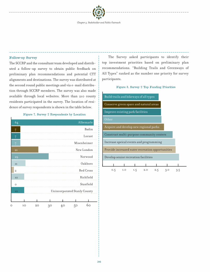
36
Follow-up Survey
The SCCRP and the consultant team developed and distrib-
uted a follow-up survey to obtain public feedback on
preliminary plan recommendations and potential CTT
alignments and destinations. The survey was distributed at
the second round public meetings and via e-mail distribu-
tion through SCCRP members. The survey was also made
available through local websites. More than 210 county
residents participated in the survey. The location of resi-
dence of survey respondents is shown in the table below.
Figure 7. Survey 2 Respondents by Location
0 10 20 30 40 50 60
Albemarle
Badin
Locust
Misenheimer
New London
Norwood
Oakboro
Red Cross
Richfield
Stanfield
Unincorporated Stanly County
64
7
7
7
21
29
11
2
10
0
10
The Survey asked participants to identify their
top investment priorities based on preliminary plan
recommendations. “Building Trails and Greenways of
All Types” ranked as the number one priority for survey
participants.
Figure 8. Survey 2 Top Funding Priorities
0.5 1.0 1.5 2.0 2.5 3.0 3.5
Build trails and bikeways of all types
Conserve green space and natural areas
Improve existing park facilities
Other
Acquire and develop new regional parks
Construct multi-purpose community centers
Increase speical events and programming
Provide increased water recreation opportunities
Develop senior recreation facilities
Chapter 4. Stakeholder and Public Outreach

37
Chapter 4. Stakeholder and Public Outreach
The survey also asked participants to rank destinations
for the Thread Trail in Stanly County. Morrow Mountain
ranked as the top destination for survey participants.
Other parks, Stanly County municipalities also ranked
high on the list. The top 10 destinations for the CTT as
ranked by survey participants is shown in the table below.
Figure 9. Survey 2 Top Ten Destinations
0 30 60 90 120 150
Morrow Mt State Park
Badin Lake
All Major Parks in County
City Lake Park
Cities and Towns in County
Uwharrie Nat’l Forest
The Fork Farm/Stables
Farmers Market (Albemarle)
Hardaway Site (Badin)
Old Whitney train trestle
146
118
112
110
107
99
86
75
63
62
Finally, the survey asked participants to rank segments
of potential CTT alignments. The rail corridor from Badin
to Old Whitney ranked as the top segment. Other top 10
indicated segments are shown on the map at right.
Figure 10: Greenway Segments with High Public Support

38
Chapter 4. Stakeholder and Public Outreach

39
ch a p t e r 5. gr e e n wa y m a s t e r p l a n t r a i l r ou t e s
The proposed Carolina Thread Trail route for Stanly County
is outlined in this chapter and reflects the community prior-
ities articulated through the public input process. Chapter
4 of this plan outlines the community input process that
informed the Carolina Thread Trail and Greenway Master
Plan recommendations. Public outreach was local and
grassroots-oriented, with varied and extensive methods to
involve the community.
The recommended route includes a total of 109.2
miles of greenways. Of this total, 13.1 miles of greenways
represent trails previously recommended in other local
planning efforts. The remaining 94.3 miles of newly-
proposed greenways are located along streams, utility
rights-of-way, and rail corridors. Other trails take
advantage of existing and proposed sidewalks, and existing
road rights-of-way. Trails on sidewalks are better suited
for pedestrians and children than for adult bicyclists. To
accommodate these users, it is assumed that the addition
of parallel bicycle facilities would be required. Although
they are not counted as part of the Carolina Thread Trail’s
mileage, the Master Plan proposes blueways along Rocky
River, Yadkin River, Long Creek, and Long Lake.
The proposed greenway routes connect the munici-
palities of Misenheimer, Richfield, New London, Albe-
marle, Oakboro, Locust, Stanfield, Norwood, and Badin.
In Table 9, which outlines the proposed Carolina
Thread Trail route, ID numbers refer to the segment
numbers on Figure 11.
Figure 11 depicts the location of the proposed trails.
The trails are identified with thick lines that represent
¼-mile corridors of land. It is not intended that the
Carolina Thread Trail would encompass an entire ¼-mile
corridor of land; rather, the ¼-mile corridor allows
flexibility in identifying the final alignment of a trail
when the alignments are studied in more detail.
Table 8 shows the mileage of proposed trails per Stanly
County community. The mileage does not reflect planned
or proposed local greenways per adopted local plans. The
mileage does also not reflect proposed blueways.
Tables 9 and 10 present a summary description of the
proposed CTT and other trail routes. The table outlines
trail types, lengths, connections made, and access.
The Carolina Thread Trail would connect 10 towns,
17 destinations, 22 schools, and tens of thousands of
residents.
Table 8: Trail Mileage by CommunityStanly County Carolina Thread Trail
JurisdictionsProposed
CTT RouteLocal
Opportunities
Albemarle 9.7 5.4
Badin 1.8 0.4
Locust 2.6 0.6
Misenheimer 1.9 0
New London 1.6 0.4
Norwood 3.4 0
Oakboro 1.3 0.5
Red Cross 0 0
Richfield 2.1 0.7
Stanfield 4.2 .2
Stanly County Unincorporated
80.6 44.6
Stanly County Total 109.2 52.8

40
Chapter 5. Greenway Master Plan Trail Routes
Figure 11: Proposed CTT Routes for Stanly County

41
Chapter 5. Greenway Master Plan Trail Routes

42
Table 9: Proposed Carolina Thread Trail RouteStanly County Greenway Connection Identification
ID TYPE DESCRIPTION MILES
A Creek Corridor Along Rocky River from segment L to segment M. 11.5
B Rail Corridor Connection between Stanfield and Norwood. 18.3
C Existing Sidewalk, New Trail, Creek Corridor
From Cabarrus County line along existing sidewalk in Locust; then south on new trail to East Prong Rock Hole Creek connecting to segment B.
4.1
D Creek Corridor New Trail From segment K south along Rocky River to the Fork ending at the Montgomery County line. 4.7
F Road ROW, Existing Sidewalk, Proposed Sidewalk, New Trail
From Cabarrus County line southeast along Lambert to Five Point to Ridgecrest. Then north onto Millingport and then east on Hatley Farm Rd. to Community Rd. to Treece Rd. to Fink Rd. Continue along Hwy 73 on proposed sidewalk and enter City Lake Park. Through City Lake Park on new trail and proposed trail connecting with Kingsley Rd. on proposed sidewalk and then Main Street on existing sidewalk. Connecting with segment G in Albemarle.
15.1
G Proposed Trail, Proposed Sidewalk, Road ROW, Existing Trail
From Segment F on Main Street follow proposed trail north on rail corridor and then east along Melchor Branch to proposed sidewalk on Moss Springs Rd. Then take NC 740 north to Morrow Mountain Road. Follow Morrow Mountain Road east to Morrow Mountain State Park entrance. Continue through the park, ending at the boat ramp.
11.3
H Proposed and Existing Trail, Proposed Sidewalk, Creek Corridor, Road ROW
From segment G follow proposed trail south from NC 740 to proposed sidewalk on Main Street and then along Anderson Road to Jacobs Creek corridor. Follow Jacobs Creek and then take Dennis Road to unnamed creek corridor going south to Pee Dee Road. Take Pee Dee Road to Norwood proposed trail ending on Norwood existing trail and connecting with segment B in Norwood.
12
K Rail Corridor, Proposed Trail
From segment B in Norwood south along rail corridor to proposed trail ending at the Rocky River.
3.0
L Creek Corridor South along Long Creek from segment B to the Rocky River. 1.6
M Creek Corridor From junction with segments B and C, south along East Prong Rock Hole Creek to Rock Hole Creek ending at the Rocky River.
4.2
N Creek Corridor, Proposed Trail
North from Morrow Mountain State Park along Little Mountain Creek connecting into Badin along proposed trail.
3.2
P Proposed Trail, Rail Corridor
From Badin north along proposed trail to rail corridor ending at Old Whitney. 4.9
Q Rail Corridor, Proposed Trail
From Old Whitney west along rail corridor to proposed trail ending at the junction with segments R and S.
5.8
R Utility Corridor, Road ROW
From segment Q and S; north along Hwy 52 to New London. Then west along Steakhouse Road. Follow utility corridor north along Town Creek into Richfield. Then connect to existing sidewalk on Church Street to Main Street. Take Curl Tail Creek west into Richfield Community Park and connect to utility corridor. Take utility corridor to Pfeiffer Road to existing sidewalk on Hwy 52. Take Lions Club to Glenmore ending at the Cabarrus County line.
9.2
Chapter 5. Greenway Master Plan Trail Routes

43
Table 10: Proposed Other Connection Opportunities (Green Routes) Stanly County Greenway Connection Identification
E Road ROW, New Trail Connection from Rocky River to segment M via new trail. 2.7
I Creek Corridor Proposed Trail
From Albemarle take proposed trail south to Long Creek. Follow Long Creek south to Hartsell Rd.; then take St Martin Rd. connecting to segment W.
9.7
J Creek Corridor Road ROW
From Junction with segment B south along Hardy Creek ending at the Rocky River. Optional route from Hardy Creek along Mt. Zion Road to Plank Road ending at Plank Road bridge at the Rocky River
7.7
O Proposed Trail, New Trail
From Badin follow proposed trail east to new trail that connects to Morrow Mountain State Park.
5.0
S Proposed Trail From junction with segment G in Albemarle north along proposed trail to junction with segments Q and R.
4.2
T Creek Corridor From junction with segment R in Richfield follow Curl Tail Creek to junction with blueway segment BB.
2.3
U Road ROW, Utility Corridor
From junction with segment G south along utility corridor to Strand Road to Fox Road to Tar Heel road ending at the Hwy 24/27 bridge and the Montgomery County line.
5.5
V Creek Corridor From junction with segment B in Aquadale south along Alligator Branch to the Rocky River. 2.5
W Road ROW, Existing Sidewalk
From junction with segment F south along Ridgecrest Road to Frog Pond Road to Hazard Road and connect to segment B.
9.0
X Utility Corridor, Creek Corridor
From junction with segment B in Oakboro south along utility corridor to Coldwater Branch ending at the Rocky River.
3.6
Y Existing Sidewalk From junction segments C in Locust travel east on existing sidewalk to Locust City Park 0.6
Proposed Blueway Opportunities (Blue Routes)
A A Blueway Rocky River from Cabarrus County to the Fork 39.7
BB Blueway Blueway along Riles Creek/Yadkin River to Roan County line. 1.8
CC Blueway Blueway south along Long Creek to Long Lake 2.0
DD Blueway Blueway south from Roan County line to Anson County line 31.4
Chapter 5. Greenway Master Plan Trail Routes
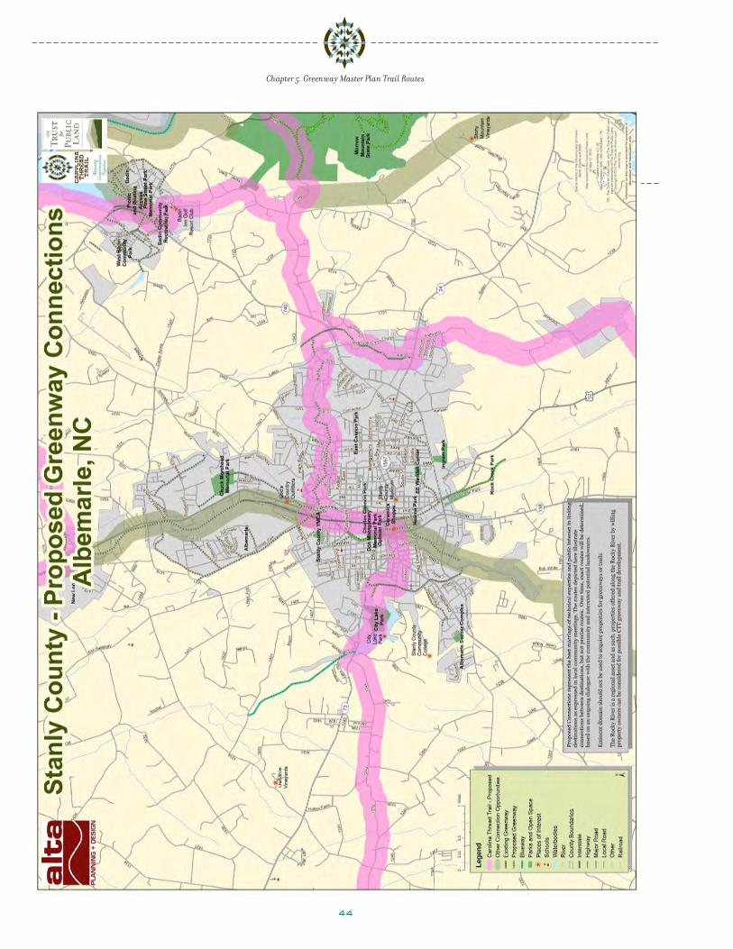
44
Chapter 5. Greenway Master Plan Trail Routes

45
Chapter 5. Greenway Master Plan Trail Routes
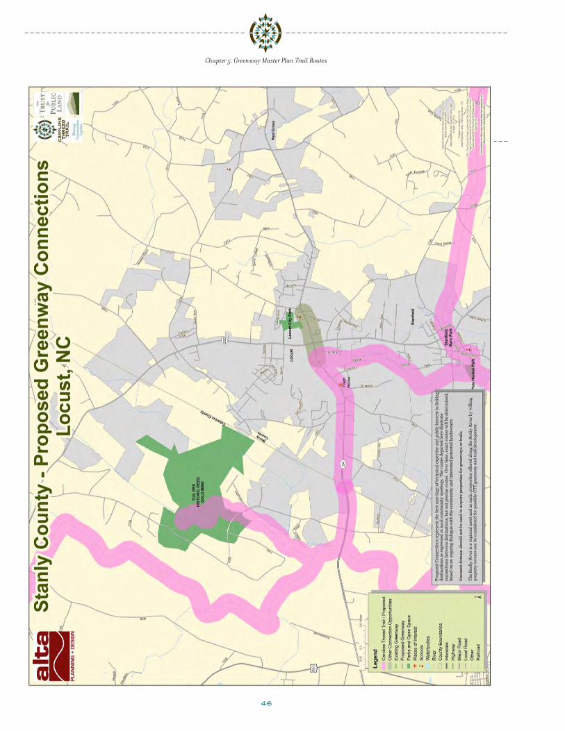
46
Chapter 5. Greenway Master Plan Trail Routes

47
Chapter 5. Greenway Master Plan Trail Routes
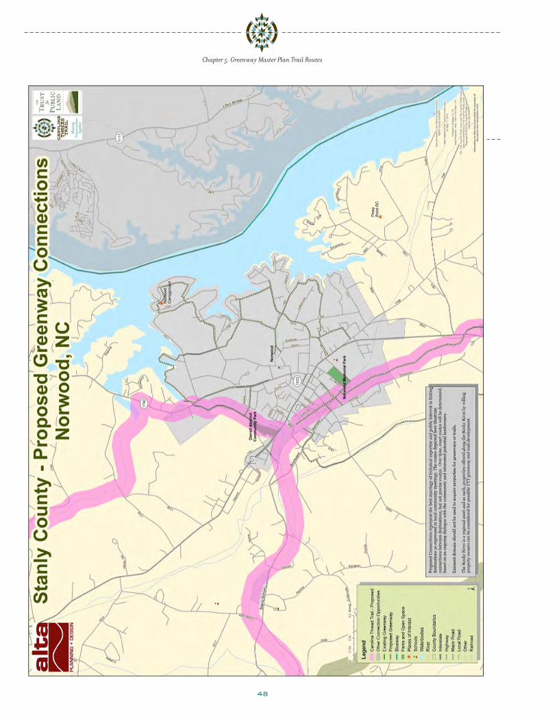
48
Chapter 5. Greenway Master Plan Trail Routes

49
Chapter 5. Greenway Master Plan Trail Routes

50
Chapter 5. Greenway Master Plan Trail Routes
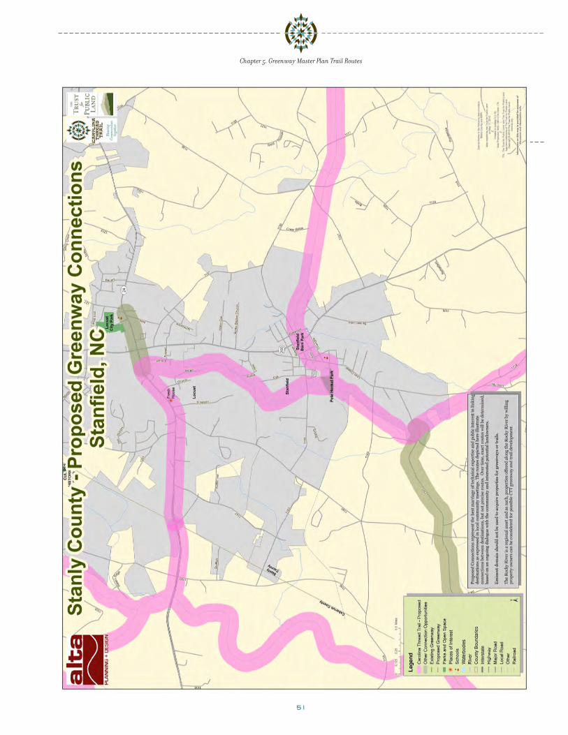
51
Chapter 5. Greenway Master Plan Trail Routes
52
Chuck Morehead Memorial Park, Albemarle (photo: City of Albemarle)

53
a d op t t h e p l a nThe Carolina Thread Trail Greenway Master Plan for Stanly
County Communities will be an important tool for County
and municipal residents, boards, and officials as the
community makes decisions about economic develop-
ment, land use, transportation, open space preservation,
environmental protection, and recreation development
in Stanly County. Adopting the Carolina Thread Trail Plan
for Stanly County is a critical first step in identifying the
County’s trail opportunities and challenges and will influ-
ence County and municipal policy and decisions regarding
trail development in the County. Adopting the Master Plan
will help Stanly County get the Carolina Thread Trail built,
by making the County eligible for funding by CTT and other
sources and provide key political and public support for this
visionary effort.
bu i l d p u bl ic s u p p or t
Establish a “Friends of the Carolina Thread Trail”
Organization
A trail system such as the Carolina Thread Trail will be
most successful when supported by a county-wide citizens’
group. Stanly County communities have tremendous social
capital that should be tapped to provide implementation
opportunities for the Carolina Thread Trail. The primary
purpose of a Friends group would be to generate support
and interest in the Carolina Thread Trail among local and
regional partners. Ultimately, such a group should work
to ensure that public and political interest in the Carolina
Thread Trail remains high and that the trails are success-
fully used and maintained once built.
A Friends group could organize events that improve
the trail corridors, including tree plantings, clean-up
ch a p t e r 6. r e c om m e n de d ac t ions f or i m p l e m e n t a t ion
activities, trail monitoring, bridge building, and invasive
plant removal. The group could work with other civic
organizations and local businesses to get in-kind donations
for cleaning up trail corridors (e.g., a local hauling service
could donate a truck to haul away debris or a local nursery
could donate native plants for enhancement activities).
The group could also work with local artists and designers,
as well as students from local schools, colleges, and
universities, to develop user maps and signs, interpretive
illustrations, and functional artwork for the corridor. The
group could also perform fundraising activities for trail
enhancements, such as interpretive sites in the County.
Additionally, the group could be responsible for assisting
the County and municipalities with grant writing efforts
to secure state funding for the next phases of development.
Develop a Trail Identity for Stanly County
A unique and identifiable image for trail and greenway signs
in the county will create a sense of continuity and consis-
tency throughout the trail corridors, especially on local
greenways that tie into the Carolina Thread Trail. Project
partners could coordinate with local schools, artists, and
college and university students to develop an image or
concept that embodies the trail and greenway corridors
for trail signs, interpretive areas, and maps and that ties in
with the overall CTT identity and logo elements. Potential
themes include:
• Dominant landscape elements – creeks, the lakes, Rocky
River, hills and mountains, vegetation
• Walking and bicycling elements – silhouettes of people
walking and riding, equipment
• Place names – community names; creek, river, or lake
name
• Historic elements – pioneers, Native American cultures,
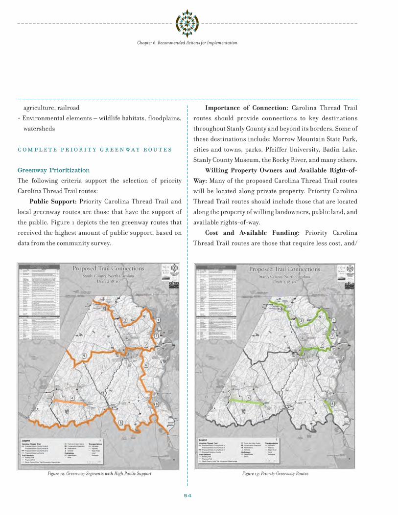
54
agriculture, railroad
• Environmental elements – wildlife habitats, floodplains,
watersheds
c om p l e t e p r ior i t y gr e e n wa y r ou t e s
Greenway Prioritization
The following criteria support the selection of priority
Carolina Thread Trail routes:
Public Support: Priority Carolina Thread Trail and
local greenway routes are those that have the support of
the public. Figure 1 depicts the ten greenway routes that
received the highest amount of public support, based on
data from the community survey.
Importance of Connection: Carolina Thread Trail
routes should provide connections to key destinations
throughout Stanly County and beyond its borders. Some of
these destinations include: Morrow Mountain State Park,
cities and towns, parks, Pfeiffer University, Badin Lake,
Stanly County Museum, the Rocky River, and many others.
Willing Property Owners and Available Right-of-Way: Many of the proposed Carolina Thread Trail routes
will be located along private property. Priority Carolina
Thread Trail routes should include those that are located
along the property of willing landowners, public land, and
available rights-of-way.
Cost and Available Funding: Priority Carolina
Thread Trail routes are those that require less cost, and/
Figure 12: Greenway Segments with High Public Support Figure 13: Priority Greenway Routes
Chapter 6. Recommended Actions for Implementation
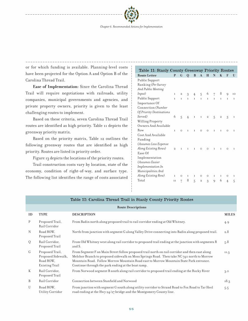
55
or for which funding is available. Planning-level costs
have been projected for the Option A and Option B of the
Carolina Thread Trail.
Ease of Implementation: Since the Carolina Thread
Trail will require negotiations with railroads, utility
companies, municipal governments and agencies, and
private property owners, priority is given to the least
challenging routes to implement.
Based on these criteria, seven Carolina Thread Trail
routes are identified as high priority. Table 11 depicts the
greenway priority matrix.
Based on the priority matrix, Table 12 outlines the
following greenway routes that are identified as high
priority. Routes are listed in priority order.
Figure 13 depicts the locations of the priority routes.
Trail construction costs vary by location, state of the
economy, condition of right-of-way, and surface type.
The following list identifies the range of costs associated
Table 12: Carolina Thread Trail in Stanly County Priority Routes
Route Descriptions
ID TYPE DESCRIPTION MILES
P Proposed Trail, Rail Corridor
From Badin north along proposed trail to rail corridor ending at Old Whitney. 4.9
N Road ROW, Proposed Trail
North from junction with segment G along Valley Drive connecting into Badin along proposed trail. 2.8
Q Rail Corridor, Proposed Trail
From Old Whitney west along rail corridor to proposed trail ending at the junction with segments R and S.
5.8
G Proposed Trail, Proposed Sidewalk, Road ROW, Existing Trail
From Segment F on Main Street follow proposed trail north on rail corridor and then east along Melchor Branch to proposed sidewalk on Moss Springs Road. Then take NC 740 north to Morrow Mountain Road. Follow Morrow Mountain Road east to Morrow Mountain State Park entrance. Continue through the park ending at the boat ramp.
11.3
K Rail Corridor, Proposed Trail
From Norwood segment B south along rail corridor to proposed trail ending at the Rocky River 3.0
B Rail Corridor Connection between Stanfield and Norwood 18.3
U Road ROW, Utility Corridor
From junction with segment G south along utility corridor to Strand Road to Fox Road to Tar Heel road ending at the Hwy 24/27 bridge and the Montgomery County line.
5.5
Table 11: Stanly County Greenway Priority RoutesRoute Letter P G Q B A H N K F UPublic Support Ranking (Per Survey And Public Meeting Input) 1 2 3 4 5 6 7 8 9 10Public Support 1 1 1 1 1 1 1 1 1 1Importance Of Connection (Number Of Priority Destinations Served) 6 5 4 1 1 2 5 2 3 1Willing Property Owners And Available Row 1 0 1 1 0 0 1 1 0 1Cost And Available Funding(Assumes Less Expense Along Existing Rows) 2 1 1 1 0 0 1 1 0 1Ease Of Implementation (Assumes Easier Implementation In Municipalities And Along Existing Row) 1 0 1 1 0 0 1 1 0 1Total 11 7 8 5 2 3 9 6 4 5
Chapter 6. Recommended Actions for Implementation

56
with different trail surface types. These costs are
based on local construction sources, as well as national
sources (including the Rails-to-Trails Conservancy) and
experience in other regions. Costs are given per mile, and
do not include land acquisition.
Asphalt - $100K - $750K
Concrete - $300K - $500K
Crushed/granular stone - $60K - $130K
Soil cement - $60K - $100K
Resin-based stabilized material – varies
Boardwalk - $1.5 mil – $2 mil
i n i t i a t e o t h e r p r ior i t y ac t ion s t e p s a n d p ol ic y r e c om m e n d a t ionsThis Carolina Thread Trail Greenway Master Plan for Stanly
County Communities is intended to serve as a point of
beginning in developing a network of trails in Stanly County
with connections to the surrounding region. The steps
required to implement the trails identified in this plan
will vary by project and by municipality. The goals, recom-
mended policies, and action steps listed below supply the
policy and implementation framework for the Master Plan
at the county and municipal level.
The aspirations of county residents and other
stakeholders expressed during the planning process are
directly reflected in the recommended action steps. The
recommendations are a composite of feedback from focus
groups and stakeholders, Steering Committee input,
the county-wide park and recreation needs assessment
survey, youth survey, a follow-up survey, as well as eight
public meetings during the planning phase of the project.
Throughout all of the public outreach efforts, trails were a
top priority for Stanly County residents.
This master planning process is ongoing, and will
require continual re-examination of goals and priorities
to reflect shifts in user patterns, community desires,
demographics, availability of land and availability of
financial resources. As such, the recommendations
addressed in this master plan should be regularly reviewed
and updated.
The following action steps and policy recommendations
should be considered in planning and implementing
future Carolina Thread Trail improvements in Stanly
County.
Action Step #1
Strategically pursue trail projects to maximize results and
minimize costs.
1.1 Study for feasibility and develop the proposed Carolina
Thread Trail routes (approximately 90 miles) and other
recommended local greenways/trails as reflected in the
adopted Carolina Thread Trail Greenway Master Plan for
Stanly County Communities as well as locally adopted
pedestrian, bicycle, and greenway plans.
1.2 Pursue land and/or easements and funding for higher-
priority trail projects first.
1.3 Work with local agencies and private landholders to
secure trail easements and access to greenspace for trail
connections.
1.3.1 As opportunities arise with willing land owners, protect
land for a greenway along the Rocky River corridor, as
recommended in the Stanly County Land Use Plan.
1.3.2 Coordinate with local railroad owners and operators
for potential rail-with-trail or rail-to-trail opportunities.
1.3.3 Provide coordination with other trail development
efforts in the region (e.g., PTCOG plan for Piedmont
counties; Mountain to Sea Trail; Uwharrie trails;
surrounding counties).
1.3.4 Coordinate with NCDOT and the Rocky River RPO for
opportunities to fund and develop Carolina Thread Trail
routes.
1.4 In the case where grant requirements or construction
in conjunction with another project make construction
of a lower priority trail project possible, pursue funding
Chapter 6. Recommended Actions for Implementation
57
sources for that trail project regardless of priority.
1.5 Publish a public report documenting the status and
ongoing actions for all trail projects at the end of each
fiscal year.
Action Step # 2
Ensure that the Carolina Thread Trail Master Plan for Stanly
County project list is current and relevant.
2.1 Review and update the Carolina Thread Trail Greenway
Master Plan for Stanly County Communities as needed,
within a minimum of every ten years, with input from
the SCCRP, Carolina Thread Trail Subcommittee, local
advocacy groups, and land use agencies.
2.2 Share updated Carolina Thread Trail Master Plan project
list with the public and the municipalities.
Action Step # 3
Integrate Carolina Thread Trail planning and construction
into the municipalities’ day-to-day activities of plan-
ning, designing, funding, constructing and maintaining
infrastructure.
3.1 Promote recreation easements and open space corridors
through existing and future development areas for use as
linear parks and trails. Integrate the siting of proposed
trail segments into the development review process.
3.2 Install approved trail projects simultaneous with road,
stormwater, or utility improvements projects scheduled
in the same area, regardless of the priority placed upon a
trail project.
3.3 Adopt policies that promote walking and bicycling.
3.4 Adopt a Complete Streets Policy to ensure that
consideration of bicycle and pedestrian facilities are
included in all major construction and reconstruction
projects. Bicycle and pedestrian facilities should be
addressed at the project scoping stage.
Action Step # 4
Encourage private donors to support the Carolina Thread
Trail
4.1 Institute an “Adopt a Trail” program to encourage
corporations, institutions and individual private donors
to support the Carolina Thread Trail system.
4.2 Leverage this program to enhance maintenance
through volunteer work to can connect philanthropy with
fundraising to sustain the system.
4.3 Evaluate the opportunities for establishing a
philanthropic giving program that can be used to support
the construction and maintenance of Stanly County’s
Carolina Thread Trail.
Action Step #5
Qualitatively measure Stanly County’s progress toward
implementing the Carolina Thread Trail Master Plan
5.1 Establish measures of effectiveness to evaluate the
County’s progress toward meeting the goal outlined in
this Carolina Thread Trail Master Plan.
5.2 Include measurable indicators of progress and time-
sensitive targets for the County to meet.
f u n d t r a i l i m p l e m e n t a t ion
Funding for the Carolina Thread Trail and Local
Greenways
A variety of potential funding sources are available to
help pay for the Carolina Thread Trail in Stanly County,
including private, local, State, regional, and Federal funding
programs. Many of these involve the completion of exten-
sive applications with clear documentation of the project
need, costs, and benefits, and which compete with similar
applications from other communities.
A summary of potential public funding sources for trail
projects is provided in Appendix III. Some are restricted
to specific types of improvements. It is important to note
Chapter 6. Recommended Actions for Implementation
58
that many of the funding sources are highly competitive
and it is impossible to determine exactly which projects
will be funded by which funding sources. It is also difficult
to pinpoint the timing of projects, due to dependence
on competitive funding sources, timing of related
infrastructure and development projects, and the overall
economy.
Right-Of-Way Acquisition Strategies For Trails
The relationship of the parties in a trail corridor will be
driven to a great extent by which entity holds the domi-
nant property interest. The type of property acquisition
influences both the ease of implementing the project
and the liability burden. There are four types of property
acquisition: purchases, landowner incentive measures,
conservation easements, and licenses.
Purchases
Market Value PurchaseThrough a written purchase and sale agreement, a
local government purchases land at the present market
value based on an independent appraisal. Timing, payment
of real estate taxes and other contingencies are negotiable.
Partial Value Purchase (or Bargain Sale)In a bargain sale, the landowner agrees to sell for
less than the property’s fair market value. A landowner’s
decision to proceed with a bargain sale is unique and
personal; landowners with a strong sense of civic pride,
long community history or concerns about capital gains are
possible candidates for this approach. In addition to cash
proceeds upon closing, the landowner may be entitled to
a charitable income tax deduction based on the difference
between the land’s fair market value and its sale price.
Option to Purchase AgreementThis is a binding contract between a landowner and the local
government that would only apply according to the condi-
tions of the option and limits the seller’s power to revoke
an offer. Once in place and signed, the Option Agreement
may be triggered at a future, specified date or upon the
completion of designated conditions. Option Agreements
can be made for any time duration and can include all of the
language pertinent to closing a property sale.
Right of First RefusalIn this agreement, the landowner grants the local
government the first chance to purchase the property
once the landowner wishes to sell. The agreement does
not establish the sale price for the property, and the
landowner is free to refuse to sell it for the price offered
by the government agency. This is the weakest form of
agreement between an owner and a prospective buyer.
Life Estates & BequestsIn the event a landowner wishes to remain on the
property for a long period of time or until death, several
variations on a sale agreement exist. In a life estate
agreement, the landowner may continue to live on the land
by donating a remainder interest and retaining a “reserved
life estate.” Specifically, the landowner donates or sells the
property to the local government, but reserves the right for
the seller or any other named person to continue to live on
and use the property. When the owner or other specified
person dies or releases his/her life interest, full title
and control over the property will be transferred to the
local government. By donating a remainder interest, the
landowner may be eligible for a tax deduction when the gift
is made. In a bequest, the landowner designates in a will
or trust document that the property is to be transferred to
the local government upon death. While a life estate offers
the local government some degree of title control during
the life of the landowner, a bequest does not. Unless the
intent to bequest is disclosed to and known by the local
government in advance, no guarantees exist with regard
to the condition of the property upon transfer or to any
liabilities that may exist.
Chapter 6. Recommended Actions for Implementation
59
Landowner Incentive Measures
The following tools should be considered by the County and
local municipalities as a means to incentivize developer
participation in the development of the Carolina Thread
Trail and local greenway network.
Density BonusesDensity bonuses are a planning tool used to encourage
a variety of public land use objectives, usually in urban
areas. They offer the incentive of being able to develop
at densities beyond current regulations in one area, in
return for concessions in another. Density bonuses are
applied to a single parcel or development. An example
is allowing developers of multi-family units to build at
higher densities if they provide a certain number of low-
income units or public open space. For density bonuses
to work, market forces must support densities at a higher
level than current regulations.
IRC 1031 ExchangeIf the landowner owns business or investment
property, an IRC Section 1031 Exchange can facilitate
the exchange of like-kind property solely for business or
investment purposes. No capital gain or loss is recognized
under Internal Revenue Code Section 1031 (see www.irc.
gov for more details).
Conservation Easements
In most instances, full ownership acquisition is not
necessary for trail development, and, in many cases, is not
really an option. Easements typically are acquired when
the landowner is willing to forego use of the property
and development rights for an extended period. Through
a conservation easement, a landowner voluntarily agrees
to sell or donate certain rights associated with his or
her property – often the right to subdivide or develop
– and a private organization or public agency agrees to
hold the right to enforce the landowner’s promise not to
exercise those rights. In essence, the rights are forfeited
and no longer exist. This is a legal agreement between
the landowner and the local government (or private
organization) that permanently limits uses of the land in
order to conserve a portion of the property for public use
or protection.
Typically, this approach is used to provide trail
corridors where only a small portion of the land is needed
or for the strategic protection of natural resources and
habitat. The landowner still owns the property, but the
use of the land is restricted. Conservation easements may
result in an income tax deduction and reduced property
taxes and estate taxes. The preservation and protection of
habitat or resources lands may best be coordinated with
the local land trust or conservancy, since that organization
will likely have staff resources, a systematic planning
approach and access to non-governmental funds to
facilitate aggressive or large scale transactions.
The list below provides an overview of easement
agreement issues.
Easement AgreementA model easement agreement should:
• Guarantee exclusive use or uses compatible.
• Be granted in perpetuity.
• Include air rights if there is any possible need for a
structure.
• Broadly define purpose of the easement and identify all
conceivable activities, uses, invitees, and vehicular types
allowed to avoid any need to renegotiate with fee interest
owner in future.
• State that all structures and fixtures installed as part of a
trail are property of grantee.
• Include subsurface rights for use by utility franchises.
It is also understood that major landowners would
want an easement agreement to address issues on their
side. Through cooperative negotiation, the following
issues should be addressed in an easement agreement:
• Access needs related to maintenance, etc.
Chapter 6. Recommended Actions for Implementation
60
• Trail management plan.
• Future improvements or modifications to the trail.
Licenses
A license is usually a fixed-term agreement that provides
limited rights to the licensee for use of the property.
Typically, these are employed in situations when the prop-
erty cannot be sold (e.g., a publicly owned, active electrical
utility corridor), or the owner wants to retain use of and
everyday control over the property. The trail manage-
ment authority obtains permission to build and operate a
trail. However, it will have little control over the property,
and may be subject to some stringent requirements that
complicate trail development and operation. The list below
provides an example of model license agreement language.
License AgreementA model license agreement should:
• Provide an acceptable term length with an option to
renew.
• Identify all conceivable activities, uses, invitees, and
vehicular types.
• Provide clarity on maintenance responsibilities.
• Specify limits on other uses of license property.
As with easement agreements, property owners would
want a license agreement to address issues on their side.
Through cooperative negotiation, the following issues
should be addressed in a license agreement:
• Access needs related to maintenance, etc.
• Trail management plan.
• Future improvements or modifications to the trail.
Chapter 6. Recommended Actions for Implementation

61
ch a p t e r 7. c onclu sion
Through a collaborative planning process commu-
nity members in Stanly County articulated a sense of place
and showed excitement about honoring special landscapes
and destinations for economic, psychological, cultural and
health reasons by connecting them and interacting with
them on foot, on horseback, on bicycle and other modes.
Given the rate of growth in Stanly County, this proposal
is not for a luxury good but a necessary good. This report
outlines an ambitious plan for developing a comprehensive
network of trails across Stanly County.
The many community partners who have been involved
in the planning process recognize the urgency of starting a
county-wide and region-wide linear park system now, while
opportunities still exist for making connections and linking
important places. They also recognize that this plan will not
be implemented overnight, and that while segments should
begin appearing soon, it will take years, if not decades, to
link them all together. The time to start is now.

62
Chapter 7. Conclusion

63
a p p e n di x i:de sign gu ide l i n e s
The Carolina Thread Trail system will accommodate a
wide range of users including: pedestrians, bicyclists,
equestrians, kayakers, canoers, and persons with mobility
impairments. The Carolina Thread Trail system will also
pass through a number of different landscapes in Stanly
County. Trail character will vary in response to the land-
scape or built environment in which is located.
There are a number of federal, state and local
guidelines that apply to pedestrian and bicycle facilities.
While these documents are not absolute standards, public
agencies may require projects to meet the guidelines as a
minimum condition for key dimensions including slope,
horizontal and vertical clearances, surface conditions,
signage and pavement markings.
This section presents trail design guidelines for typical
facilities that may occur in Stanly County, including:
• Paved Multi-Use Paths and Bikeways
• Natural Surface Trails
• Rails-with-Trails
• Unique Trail Applications
• Accessible Trails
• Trails and Roadway Crossings
• Signs and Way-finding
• Trail Amenities
• Drainage and Erosion Control
These design guidelines are based on applicable
mandatory or advisory state and federal standards and
are not engineering specifications. Design engineering
should be conducted by licensed professionals and should
meet all local design and construction standards.
r e f e r e nce m a t e r i a l sReference materials used to support the design guideline
recommendations include:
AASHTO Guidelines for the Development of Bicycle
Facilities, 1999
A new version of the AASHTO Guide is anticipated to be
released in 2010. The current version of this nationally
recognized document is the 3rd Edition, dated 1999. The
new guide is anticipated to be nearly three times larger than
the 1999 edition, with significant alterations. Additional
content includes over seventy pages on the design of
on-street bicycle facilities. The new guidelines should be
used to update the design guidelines when they become
available.
Manual of Uniform Traffic Control Devices (MUTCD),
2009
The 2009 Federal MUTCD includes
Part 9: Traffic Controls for Bicycle
Facilities, along with detailed guide-
lines for pedestrian facilities
crossings available, and is available
online at: http://mutcd.fhwa.dot.
gov/kno_2009.htm.
Equestrian Design Guidebook for Trails, Trailheads
and Campgrounds
The needs of equestrians require specific design treat-
ments. The Equestrian Design
Guidebook for Trails, Trailheads
and Campgrounds was devel-
oped for the U.S. Forest
Service in cooperation with

64
the Recreational Trails Program of the Federal Highway
Administration in 2007. This guide provides practical
strategies and models for developing recreation opportuni-
ties for equestrians, including trail and amenity design.
North Carolina Department of Transportation
(NCDOT) Guidelines and Resources
In North Carolina, bicycles are legally defined as vehicles.
NCDOT publishes “A Guide to North Carolina Bicycle
and Pedestrian Laws” as a reference document for plan-
ners, citizens and law enforcement officials, available on
NCDOT’s website. Other documents available on the website
are the Greenways Administrative Process and the Bicycle and
Bikeways Act. The website can be accessed at: http://www.
ncdot.org/transit/bicycle/laws/laws_intro.html
NCDOT also publishes the Bicycle Facilities
Planning and Design Guidelines. Published in 1994, this
comprehensive manual outlines detailed planning and
design considerations specific to North Carolina.
Rails-with-Trails: Lessons Learned
This report was prepared
at the direction of the
U.S. Department of
Transportation for the
purpose of examining safety,
design, and liability issues
associated with the develop-
ment of shared use paths and
other trails within or adja-
cent to active railroad and
transit rights-of-way. This
document is intended to explore lessons learned from the
experience of Rails-with-Trails (RWTs), and suggest prac-
tices to enhance safety and security for railroads, transit,
and trail users.
Universal Design/ADA
Access
Good design for the Caro-
lina Thread Trail will ensure
universal access for all. In
addition, all greenway paths
and other trails that re-
ceive funding from state or federal sources must conform
to Americans with Disabilities Act (ADA) guidelines. The
Federal Highway Administration publishes a guidebook
entitled Designing Sidewalks and Trails for Access. Chapter 5,
Trail Design for Access is the most relevant portion of the
report and is available online at: http://www.fhwa.dot.gov/
environment/sidewalks/chap5a.htm
Another good resource is Universal Access to Outdoor
Recreation: A Design Guide, which details the systems and
elements needed to ensure universal access to recreation
sites. The guide helps users determine the appropriate
level of access for a range of outdoor sites.
Blueway Design Guidelines
The Carolina Thread Trail in Stanly County may include
designated Blueways to accommodate the growing interest
in the use of small paddlecrafts (i.e. kayaks and canoes)
to experience waterways along the trail. To assist with
designing this important element within the greenway, the
following resources can provide step-by-step guidelines
for planning, building and managing water trails:
• Water Trail Toolbox: How to Plan, Build and Manage a
Water Trail, published by the non-profit Chesapeake Bay
Gateways Network. This report can be found online at:
http://www.baygateways.net/watertrailtools.cfm.
• Blueways: A Water Trail Network for Northwestern Indiana
(Chapter Three) published by The Northwestern Indianan
Regional Planning Commission & Openland Project.
This report can be found online at: http://www.nirpc.org/
Appendix I. Design Guidelines
U.S. Department of Transportation
Federal Highway AdministrationFederal Railroad AdministrationNational Highway Traffic Safety AdministrationFederal Transit Administration
Rails-with-Trails: Lessons Learned Literature Review, Current Practices, Conclusions
August 2002
FTA-MA-26-0052-04-1

65
Appendix I. Design Guidelines
OldNirpc/pdf/Chapter%203,%20Blueways%20-%20
Part%201.pdf
t h e de sign gu i de l i n e s a r e org a n i z e d i n t o t h e f ol l o w i ng se c t ions:
Paved Multi-Use Paths and Bikeways
Paved multi-use paths and bikeways, for purposes of this
plan, include trails that meet or are proposed to meet the
dimensional, geometric and functional standards set forth
by NCDOT and AASHTO. They are paved surface multi-use
pathways, bicycle lanes, bicycle routes and bicycle boule-
vards that serve a variety of commuter trips, utilitarian
trips, and recreational trips.
Natural Surface Trails
Natural surface trails are primarily recreational trails that
serve a variety of recreational user groups. Natural surface
trails may occasionally serve transportation needs such as:
school access, commuter use, or local errands. There is no
one set of standards for natural surface trails, but there are
many resources available for constructing successful trails.
Rails-With-Trails
The linear nature of rail corridors offers trail connec-
tion opportunities that might not otherwise be available.
Railroad companies own wide rights-of-ways that often
can accommodate a trail. Trails in active rail corridors
must be designed to meet both the operational needs of
the railway system and road systems, as well as the safety of
trail users. National design standards have not been devel-
oped for Rails-With-Trails, although guidelines have been
developed from studies conducted by the Federal Highway
Administration and the Rails-To-Trails Conservancy.
Unique Trail Applications
This section will cover special trail design treatments
that may be required to complete the trail connections,
including trails in a floodplain, boardwalks, water trails and
the accommodation of non-compatible users (i.e. eques-
trians and bicyclists) in the same trail corridor. These trail
will require special attention to trail planning, design and
construction.
Accessible Trail Design
Accessible trail design is important to both recreational and
transportation trails and the standards for accessibility are
generally established by the United States Access Board and
the U.S. Department of Transportation, Federal Highway
Administration, Recreational Trails Program Guidance.
The discussion included in this section introduces the basic
concepts of accessible trail design which provide for the
needs of people with varied mobility requirements.
Trail and Roadway Crossings
The design of trail crossings of streets, roads, highways,
railroads and driveways must account for a variety of factors
and always requires site specific traffic engineering and
safety analysis. The framework presented here introduces
the key variables that influence trail crossings.
Signs and Way-Finding
A comprehensive sign system increases user safety,
comfort and helps make a trail system memorable. This
section covers regulatory, etiquette, way-finding and iden-
tity, informational and interpretive, and striping signs and
markings.
Trail Amenities
Trail support facilities should provide trail users with
the accommodations they need and encourage use of the
facilities.
Drainage and Erosion Control
Design of trails to maximize drainage, minimize erosion,
and ensure long-term sustainability is critically important
to trail and resource managers. This section introduces
basic drainage and erosion control concepts.

66
• A yellow centerline stripe is standard for multi-use
paths in many regions, especially at: blind corners, high
traffic areas, areas of narrow path width, intersection
approaches, and/or areas where nighttime riding is
expected with limited lighting.
Potential Applications
• Regional trails and local access trails to schools, parks,
and neighborhoods
• Some community connector trails and pathways.
Appendix I. Design Guidelines
pav e d m u l t i-u se pa t hs a n d bi k e wa y s
Multi-Use Paths
Multi-use paths typically have their own right-of-way and
are designed for two-way bicycle and pedestrian traffic.
These paths are also designed to accommodate mainte-
nance and emergency vehicles. This type of path should not
be used if there are numerous driveway and intersection
conflicts.
Standards
According to American Association of State and Highway
Transportation Officials (AASHTO) design standards,
two-way multi-use paths should be designed to be a
minimum of 8 feet in width. However, 8 foot wide sections
should be reserved for pinch points that have physical or
environmental constraints.
• A width of 10-12 feet is the preferred recommendation,
allowing for maintenance vehicles. Paved paths less than
12 feet have been found to break up along the edges due to
vehicle loads.
• A 10 foot vertical clearance should be maintained on
multi-use trails. This area should be free from tree
limbs and any other obstructions that may interfere with
pathway use.
• Stopping sight distance on horizontal curves and lateral
clearance can be calculated using the equations in the
AASHTO Guide 1999.
• The minimum design speed for bike paths is 20 miles per
hour, except on sections where there are long downgrades
(not applicable to grades steeper than 4% and longer than
500 feet). Speed bumps or other surface irregularities or
obstacles should never be used to slow bicycles.
10’ min vertical clearance
10’-12’ preferred 2’2’

67
Appendix I. Design Guidelines
Multi-Use Paths Adjacent to Roadways
Pathways adjacent to roadways can provide critical links
in regional trail systems where a local or NCDOT public
right-of-way is the only viable alignment alternative. These
pathway types are used where it is desirable to completely
separate multiple user groups from high speed or high
volume car traffic. Particular design attention is required
at intersections, including driveways, where motorists may
not expect bicyclists to enter the intersection. Guidance
on appropriate pathway design, warning and regula-
tory signage, and intersection control devices is available
in a variety of technical manuals (AASHTO Guidebook for
Development of Bicycle Facilities, and MUTCD) and profes-
sional engineering judgment must be applied.
Standards
• Separation from automobile traffic by a 5 foot (min.)
separation
• Trail widths of 10 feet to 12 feet (8 foot min.) to avoid
conflicts between users
• Asphalt or concrete paved surface to minimize
maintenance requirements
• Longitudinal grades of less than 5%. 2% to 3% preferred
where possible
• Cross slopes of 2% or less
• 10 foot vertical clearance
Potential Applications
• Publicly-owned easements and right-of-ways that
connect major community destinations or connect
independent communities and may provide a
non-motorized commute facility
• Rights-of-way where a separated path is feasible and
complimentary to the existing State Route transportation
function

68
Appendix I. Design Guidelines
Bike Lanes
Bike Lanes are a marked space along the length of a roadway
for exclusive use of cyclists. Bike lanes create a visual sepa-
ration between bicycle and automobile facilities, thereby
increasing bicyclist’s comfort and confidence. Bike lanes
are typically used on major through streets with average
daily traffic (ADT) counts of 3,000 or higher and should
be one-way facilities that carry bicycle traffic in the same
direction as motor vehicle traffic.
Standards
• A 5 foot width is recommended for bike lanes without
on-street parking. This width allows for added separation
between bicyclists and vehicles.
• A 5 foot minimum with normal gutter, measured from
curb face with vertical curb; or 5 feet measured from the
gutter pan seam where curb and gutter are used
• A 4 foot width minimum if no gutter exists, measured
from edge of pavement
• If adjacent to on-street parking, 5 foot width minimum.
Parking bays may vary in width up to 9 feet wide
• 10 foot vertical clearance
Potential Applications
• Streets and roads that provide connections to community
destinations, e.g. shopping, schools, library, and
employment centers.

69
Appendix I. Design Guidelines
Bike Routes
A bike route is a signed route on a road, street or path and
does not require that the road include any special bicycle
facilities. According to AASHTO, bike routes suggest to
bicyclists that a particular route has advantages over other
alternate routes. Further, AASHTO indicates that bike
routes serve one of two purposes: To provide continuity
to other bicycle facilities (usually bike lanes) or to desig-
nate preferred routes through high demand corridors. Bike
routes are typically found on lower volume streets and can
provide directional wayfinding signage to assist the bicy-
clist in navigating.
Standards
• AASHTO recommends 10- to 12-foot lanes on rural and
urban arterials (“Green Book”, 2004).
• Bicycle Route Signage installed at decision points along
designated bicycle routes and at regular intervals.
Intervals should consider the location of the bike route,
i.e. longer intervals for regional routes and shorter
intervals for local routes.
Potential Applications
• Local streets and streets without adequate width for bike
lanes
• Regional roadways where safe and convenient bicycle
travel is prioritized
• Can incorporate pavement markings,
traffic calming and other streetscape
treatments, depending on traffic volumes,
vehicle and bicycle circulation patterns,
street connectivity, street width, physical
constraints, and other parametersPavement marking

70
Bicycle Boulevards
Bicycle boulevards are bike routes on low-volume and low-
speed streets that have been optimized for bicycle travel
through treatments such as traffic calming and traffic
reduction, signage and pavement markings, and intersec-
tion crossing treatments. These treatments allow through
movements for cyclists while discouraging similar through
trips by non-local motorized traffic. Motor vehicle access to
properties along the route is maintained.
Bicycle Boulevard treatments have five main “application
levels” based on the level of physical intensity desired.
Level 1 represents the least physically-intensive treatments
that can be implemented at relatively low cost. Identifying
appropriate application levels for individual bicycle boule-
vard corridors provides a basis for selecting appropriate
site-specific improvements. The five bicycle boulevard
application level treatments include the following:
• Level 1: Signage
• Level 2: Pavement markings
• Level 3: Intersection treatments
• Level 4: Traffic calming
• Level 5: Traffic diversion
Standards
• Supplemental arrows to indicate approaching turns
• Install markings just after each intersection and in
intervals of approximately 200 feet
• Install markings near high volume driveways or other
conflict points to alert drivers.
• Pavement marking signs can range from 12 to 24 inches
in diameter (Portland, Oregon) to 30 feet long by 6 feet
wide (Berkeley, California)
• Size and placement guidance for pavement markings are
Appendix I. Design Guidelines
Frequent pavement markings act as a “breadcrumb trail” for cyclists.
Bicycle boulevard sign in Portland, Oregon.
provided in the California MUTCD.
• Apply markings with paint or thermoplastic.
Thermoplastic tends be longer lasting.
• Increase the skid resistance and retro-reflectivity by
using glass beads.
• Do not use bicycle boulevard markings or shared lane
markings within bicycle lanes.

71
Appendix I. Design Guidelines
As the route evolves and becomes more popular,
further analysis and engineering should be conducted to
determine if enhanced treatments are needed.
Potential Applications
• Low-volume and low-speed streets
• On corridors where other bikeway treatment may not be
feasible due to right-of-way of funding constraints
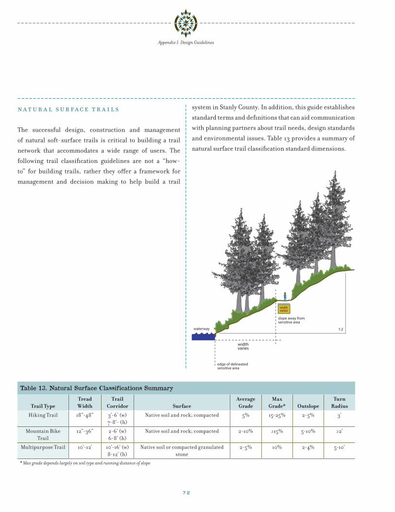
72
Appendix I. Design Guidelines
Table 13. Natural Surface Classifications Summary
Trail TypeTread Width
Trail Corridor Surface
Average Grade
Max Grade* Outslope
Turn Radius
Hiking Trail 18”-48” 3’-6’ (w)7-8’- (h)
Native soil and rock; compacted 5% 15-25% 2-5% 3’
Mountain Bike Trail
12”-36” 2-6’ (w)6-8’ (h)
Native soil and rock; compacted 2-10% ≥15% 5-10% ≥2’
Multipurpose Trail 10’-12’ 10’-16’ (w)8-12’ (h)
Native soil or compacted granulated stone
2-5% 10% 2-4% 5-10’
* Max grade depends largely on soil type and running distance of slope
n a t u r a l s u r face t r a i l s
The successful design, construction and management
of natural soft-surface trails is critical to building a trail
network that accommodates a wide range of users. The
following trail classification guidelines are not a “how-
to” for building trails, rather they offer a framework for
management and decision making to help build a trail
system in Stanly County. In addition, this guide establishes
standard terms and definitions that can aid communication
with planning partners about trail needs, design standards
and environmental issues. Table 13 provides a summary of
natural surface trail classification standard dimensions.
1:2
slope away fromsensitive area
waterway
edge of delineated sensitive area
widthvaries
widthvaries
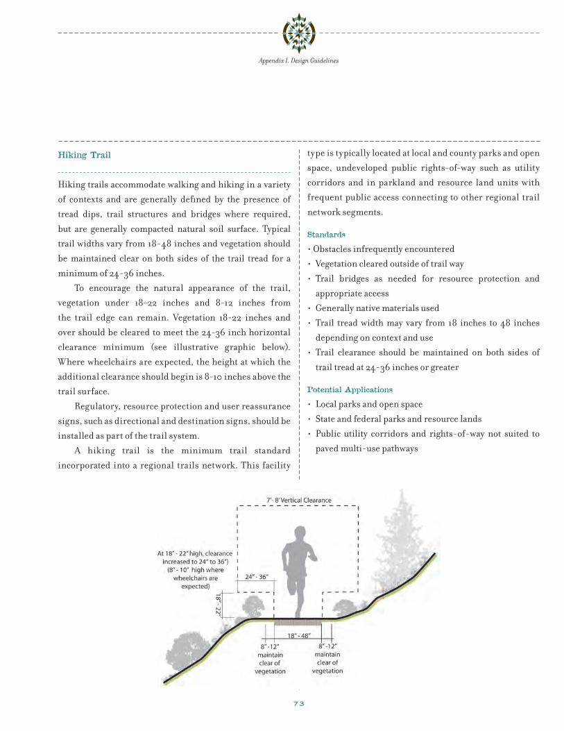
73
Appendix I. Design Guidelines
Hiking Trail
Hiking trails accommodate walking and hiking in a variety
of contexts and are generally defined by the presence of
tread dips, trail structures and bridges where required,
but are generally compacted natural soil surface. Typical
trail widths vary from 18-48 inches and vegetation should
be maintained clear on both sides of the trail tread for a
minimum of 24-36 inches.
To encourage the natural appearance of the trail,
vegetation under 18-22 inches and 8-12 inches from
the trail edge can remain. Vegetation 18-22 inches and
over should be cleared to meet the 24-36 inch horizontal
clearance minimum (see illustrative graphic below).
Where wheelchairs are expected, the height at which the
additional clearance should begin is 8-10 inches above the
trail surface.
Regulatory, resource protection and user reassurance
signs, such as directional and destination signs, should be
installed as part of the trail system.
A hiking trail is the minimum trail standard
incorporated into a regional trails network. This facility
type is typically located at local and county parks and open
space, undeveloped public rights-of-way such as utility
corridors and in parkland and resource land units with
frequent public access connecting to other regional trail
network segments.
Standards
• Obstacles infrequently encountered
• Vegetation cleared outside of trail way
• Trail bridges as needed for resource protection and
appropriate access
• Generally native materials used
• Trail tread width may vary from 18 inches to 48 inches
depending on context and use
• Trail clearance should be maintained on both sides of
trail tread at 24-36 inches or greater
Potential Applications
• Local parks and open space
• State and federal parks and resource lands
• Public utility corridors and rights-of-way not suited to
paved multi-use pathways

74
Appendix I. Design Guidelines
Mountain Bike Trail
Mountain bicyclists have a broad range of riding
abilities. This guideline for single track mountain bike
only trails focuses on recreational experience and a range
of technical challenge. The International Mountain Bike
Association (IMBA) has developed a classification system
similar to ski runs, which is indicated by the colored
symbols below. These symbols may accompany wayfinding
Table 14: Mountain Bike Trail Standards
Skill Level Tread Width SurfaceAverage
Grade Max
Grade Unavoidable
Obstacles
Easiest ≥ 72” Hardened or surfaced <5% 10% None
Easy ≥ 30” Firm and stable 5% 15% 2”
Moderate ≥ 18” Mostly stable; some variability 10% 15% 8”
Difficult ≥ 12” Variable 15% 15% 15”
Extremely Difficult ≥ 6” Widely variable & unpredictable 20% 20% 15”
and warning signage to alert bikers of upcoming trail
conditions. In addition, mountain bicyclists are typically
permitted on shared-use trails (described in the following
guideline) and should be aware that they must yield to all
other users.
Potential Applications
• Mountain bike only segments of the regional trail
network
• Topographically varied terrain

75
Appendix I. Design Guidelines
Multi-Purpose Natural Surface Trail
Unless designated otherwise, all recreation trails are
considered shared use trails. For instance, many mountain
bike trails are also open to hikers. Multi-purpose trails are
designed and managed for all types of users.
Anticipated levels of use, local public opinion and
site evaluations should be used to determine whether
or not a multipurpose trail is an appropriate solution.
Multipurpose trails are wide enough to accommodate
divergent user groups. As the width of the trail increases,
the less technical the trail can be. Regulatory signs should
be installed to alert trail users to their limitations and
responsibilities for sharing the trail.
Standards
• Tread width 8 feet to 12 feet
• Allowance for passing
• Native materials or crushed rock
• Very few obstacles
• Prevailing grade 5% or less, with limited steeper segments
• Visibility and trail clearance are an important design
consideration
Potential Applications
• Local parks and open space
• Low use areas of state and federal parks and resource
lands
• Public utility corridors and rights-of-way not suited to
paved multi-use pathways
• Not recommended as a high speed transportation facility
for cyclists

76
also providing a comfortable passing distance. This is a
common configuration for moderately developed trails in
rural settings where right-of-way is available.
Appendix I. Design Guidelines
Equestrian Trails
Trails reserved exclusively for equestrians are also called
bridle trails, bridle paths, or bridleways. The needs of eques-
trian trail users are unique, due to the natural flight instinct
of equine when startled. As with any trail design, the design
of an equestrian trail facility should respond to the setting,
needs of the trail users, level of use, and safety issues. Less
developed or rural equestrian trail settings include: rivers,
open spaces, and drainages among others. Safety concerns
for riders in rural settings involve: visibility, interactions
with other trail users and natural hazards. Urban settings
include developed or congested areas.
Equestrians include youth, elders, leisure riders,
professional riders, organized groups, novices, and
people with disabilities. Riders may recreate individually
or in groups for pleasure, exercise or challenge. While
some equestrians prefer wide, gentle trails, others seek a
technically challenging route.
Trail facilities should provide enough space so that a
horse feels at ease. Horses prefer to travel away from walls
or barriers that they cannot see through or over and are
most comfortable traveling in the tread that other stock
have traveled.
Horizontal trail clearance will vary based on the trail
setting. USDA/FHWA suggested widths, with clearance
tolerances for a standard single- and double-track horse
trails are shown in Table 15. A horse on a single-track will
often travel 18 inches from a trail edge or tread surface.
Single track treads vary from 1.5 feet in open areas to 8
feet in urban areas. Double-tracked equestrian trails are
designed to be 5 feet to 6 feet wide in open areas and are
often 8 feet to 12 feet wide in developed areas. A double-
track tread allows for equestrians to ride side by side while
Equestrians often like to travel side-by-side

77
Appendix I. Design Guidelines
Recommended guidelines for an equestrian-only trail. Source: USDA/FHWA, Equestrian Design Guidebook for Trails, Trailheads, and Campgrounds
Table 15: Suggested Widths and Clearance for a Standard, Single-Track Horse Trail
Trail Element Low development (feet)
Moderate development (feet)
High development (feet)
Trail width 1.5 to 2 3 to 6 8 to 12
Clearing width(horizontal)
5.5 to 8(Tread plus 2’ to 3’ each side)
9 to 12 (Tread plus 3’ each side)
14 to 18(Tread plus 3’ each side)
Vertical clearance (vertical)
10 10 to 12 10 to 12
Suggested Widths and Clearance for a Standard, Double-Track Horse Trail
Trail width 5 to 6 8 to 12
Clearing width(horizontal)
10 to 12(Tread plus 2’ to 3’ each side)
14 to 18 (Tread plus 3’ each side)
Vertical clearance (vertical)
10 10 to 12
Source: USDA/FHWA Equestrian Design Guidebook for Trails, Trailheads, and Campgrounds

78
Appendix I. Design Guidelines
r a i l s-w i t h-t r a i l s
Railroad rights-of-way can present opportunities for path
and trail construction. Typically, railroads follow favor-
able topography for bicycling and hiking and are located in
scenic areas. However, they also present a range of security
and safety issues for trail users that should be addressed
through planning and design processes. National design
standards have not been developed for rails with trails.
Setback is measured from the nearest edge of the trail
to the centerline of the nearest railroad track. A review of
65 existing trails as part of the “Rails-with-Trails: Lessons
Learned” study shows wide variance in the setback
distance used today. Researchers attempted to determine
if narrower setback distances have a direct correlation
to safety problems. However, based on the almost non-
existent record of claims, crashes, and other problems
on these RWTs, they were unable to conclude a strong
correlation between setback and safety. At an absolute
minimum, the setback must keep trail users outside the
“dynamic envelope” of the trains, defined as “the clearance
required for the train and its cargo overhang due to any
combination of loading, lateral motion, or suspension
Springwater Trail, Portland, Oregon
failure.” Additionally, in corridors with regular use of
maintenance equipment that operates outside the dynamic
envelope, the setback distance should allow adequate
clearance between the maintenance equipment and the
trail.
The Federal Railroad Administration (FRA) publishes
minimum setback standards for fixed objects next to
active railroad tracks, the distance between two active
tracks, and adjacent walkways (for railroad switchmen).

79
Appendix I. Design Guidelines
These published setbacks represent the legal minimum
setbacks based on the physical size of the railroad cars,
and are commonly employed along all railroads and at all
public grade crossings. Most Public Utilities Commissions
(PUCs), which regulate railroad activities within states,
also have specific minimum setbacks for any structures
or improvements adjacent to railroads, including any
sidewalk or trail that parallels active railroad tracks.
The Rails-with-Trails: Lessons Learned study outlines
preferred setback distances, with encouragement toward
as much setback distance as possible. The study details
circumstances under which a RWT can be set back
a minimum of 10 feet, with greater width preferred.
Rail operators often prefer that reduced setbacks are
accompanied by increased safety measures such as
fencing.
The standards presented below are result of studies
completed by the Federal Highway Administration
and Rails with Trails Conservancy, along with the PUC
guidelines. Other useful sources include AASHTO, and
AADAG.
Standards • A 12 foot path is strongly recommended, as these paths
often provide access for maintenance and emergency
vehicles. Paths less than 12 feet wide can crack along the
edges due to vehicle loads.
• Setbacks should be maximized and correlate with train
type, speed, frequency, and separation technique, varying
from 8.5 feet (9.5 feet on curves) to 100 feet.
• Less setback may be needed if the trail is vertically
separated
• Fencing and barriers should meet the requirements of
the railroad company
• 5 feet to 6 feet high fencing is adequate for separation in
most instances
• Vegetation may grow on fencing to buffer noise
• Storm and irrigation water from the trail should not flow
or collect in the railroad right-of-way
• At-grade trail crossings of the railroad should be
minimized
Rail with Trail, Portland, Oregon

80
Appendix I. Design Guidelines
u n iqu e t r a i l a p p l ic a t ionsSpecial trail design treatments may be required on
segments of the Carolina Thread Trail to complete the trail
system. These trails may be constructed along a creek,
within the floodplain or through sensitive biological areas
or wetlands. Additionally, there may be situations where
the available rights-of-way may require that non-compat-
ible users (i.e. equestrians and bicyclists) share the same
trail corridor. In these circumstances, special attention
should be made in the planning, design and construction
phases.
Floodway and Floodplain Trails
Trails that are developed in the floodway and floodplain
due to right-of way constraints and channelized streams
present challenges for the trail managing agency. The
main conditions in which creek and floodplain trails
occur in Stanly County are: on top of the creek bank in the
floodway and on a slope in the floodplain. These condi-
tions affect how each trail is constructed, although there
are common standards that apply to both conditions.
Floodway and Floodplain Trail Standards
• Where feasible, trails should be located outside of the
riparian forest buffer zone and active stream channel as
defined by the Natural Resource Conservation Service
of North Carolina to protect water quality and reduce
erosion of stream banks
• A width of 12 feet is the preferred recommendation,
allowing for maintenance vehicles. Paved paths less
than 12 feet have been found to break up along the edges
due to vehicle loads.
• Trails that are developed in the floodway are
recommended to be constructed of concrete, as these
trails are prone to flooding. Concrete paths are better
suited to withstand high-velocity stream flows that other
surface materials. Concrete surfaces are expensive,
however, concrete is a better community investment as it
lasts much longer than asphalt and is easier to maintain.
When properly installed, concrete will last 25 years or
longer and will need little maintenance. In wetland
areas or perennially wet areas, boardwalk or elevated
trails should be installed.
Paved multi-use path in a floodway
Paved multi-use path on a bank
Retaining wall doubles as seating

81
Appendix I. Design Guidelines
• Where the trails are located in drainage areas, and are
expected to be inundated on an annual basis, the trail
should be constructed of concrete of sufficient thickness
to allow for regular blading (cleaning) of the surface by
equipment.
• Trail shoulders should be a minimum of 2 feet
• The trail should have a 2% cross slope to direct water to a
sub drainage or swale
• The trail should be designed to discourage trespass
into environmentally sensitive areas by using natural
barriers such as split rail fencing, rocks, and native
vegetation buffers to steer people away from sensitive
areas. Interpretive signs should be installed to explain
why areas are sensitive
• Where trails are located in narrow corridors, they should
be complemented by frequent nodes to create greater
diversity of the linear experience
• Trail amenities (benches, signage, and trash receptacles)
in floodways should be carefully considered. Where
amenities are appropriate or necessary they should be
installed to withstand high velocity flows
• Retaining walls can double as seating areas and increase
pedestrian comfort along trails
• Concrete trail surfaces should be broom finished for
traction
• Joints should be saw-cut to reduce bumps.
• Concrete may be dyed any color to complement the
surrounding environment, if desired
Trails in the Floodway
The trail elevation in floodways should be set to minimized
flooding impacts. The top of the creek bank is generally
a good location for a creek trail. The top of the bank (or a
bench on a slope) is generally flat and can provide a good
platform for a trail. Because these areas are flat, grading
is kept to a minimum and existing vegetation can be
preserved. Erosion and bank stabilization problems are
also minimized. However, flooding frequency and high
water lines may require trail elevations to be set above the
creek bank. A geotechnical engineer should be consulted
to assess flood elevation levels, soil conditions and a
determination of appropriate trail profile materials and
quantities.
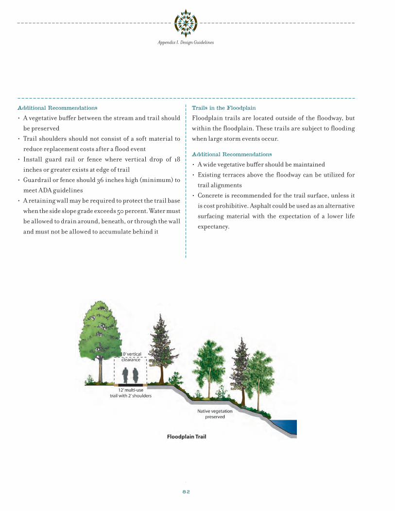
82
Appendix I. Design Guidelines
Additional Recommendations
• A vegetative buffer between the stream and trail should
be preserved
• Trail shoulders should not consist of a soft material to
reduce replacement costs after a flood event
• Install guard rail or fence where vertical drop of 18
inches or greater exists at edge of trail
• Guardrail or fence should 36 inches high (minimum) to
meet ADA guidelines
• A retaining wall may be required to protect the trail base
when the side slope grade exceeds 50 percent. Water must
be allowed to drain around, beneath, or through the wall
and must not be allowed to accumulate behind it
Trails in the Floodplain
Floodplain trails are located outside of the floodway, but
within the floodplain. These trails are subject to flooding
when large storm events occur.
Additional Recommendations
• A wide vegetative buffer should be maintained
• Existing terraces above the floodway can be utilized for
trail alignments
• Concrete is recommended for the trail surface, unless it
is cost prohibitive. Asphalt could be used as an alternative
surfacing material with the expectation of a lower life
expectancy.
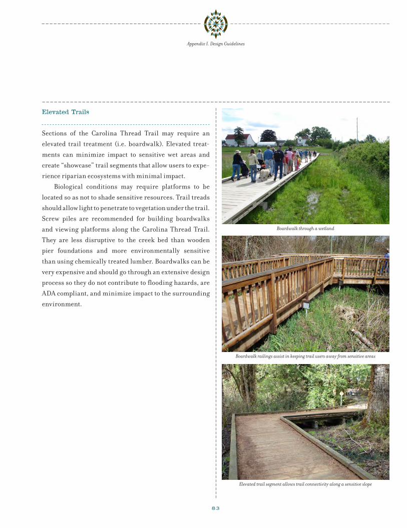
83
Appendix I. Design Guidelines
Elevated Trails
Sections of the Carolina Thread Trail may require an
elevated trail treatment (i.e. boardwalk). Elevated treat-
ments can minimize impact to sensitive wet areas and
create “showcase” trail segments that allow users to expe-
rience riparian ecosystems with minimal impact.
Biological conditions may require platforms to be
located so as not to shade sensitive resources. Trail treads
should allow light to penetrate to vegetation under the trail.
Screw piles are recommended for building boardwalks
and viewing platforms along the Carolina Thread Trail.
They are less disruptive to the creek bed than wooden
pier foundations and more environmentally sensitive
than using chemically treated lumber. Boardwalks can be
very expensive and should go through an extensive design
process so they do not contribute to flooding hazards, are
ADA compliant, and minimize impact to the surrounding
environment.
Boardwalk through a wetland
Boardwalk railings assist in keeping trail users away from sensitive areas
Elevated trail segment allows trail connectivity along a sensitive slope
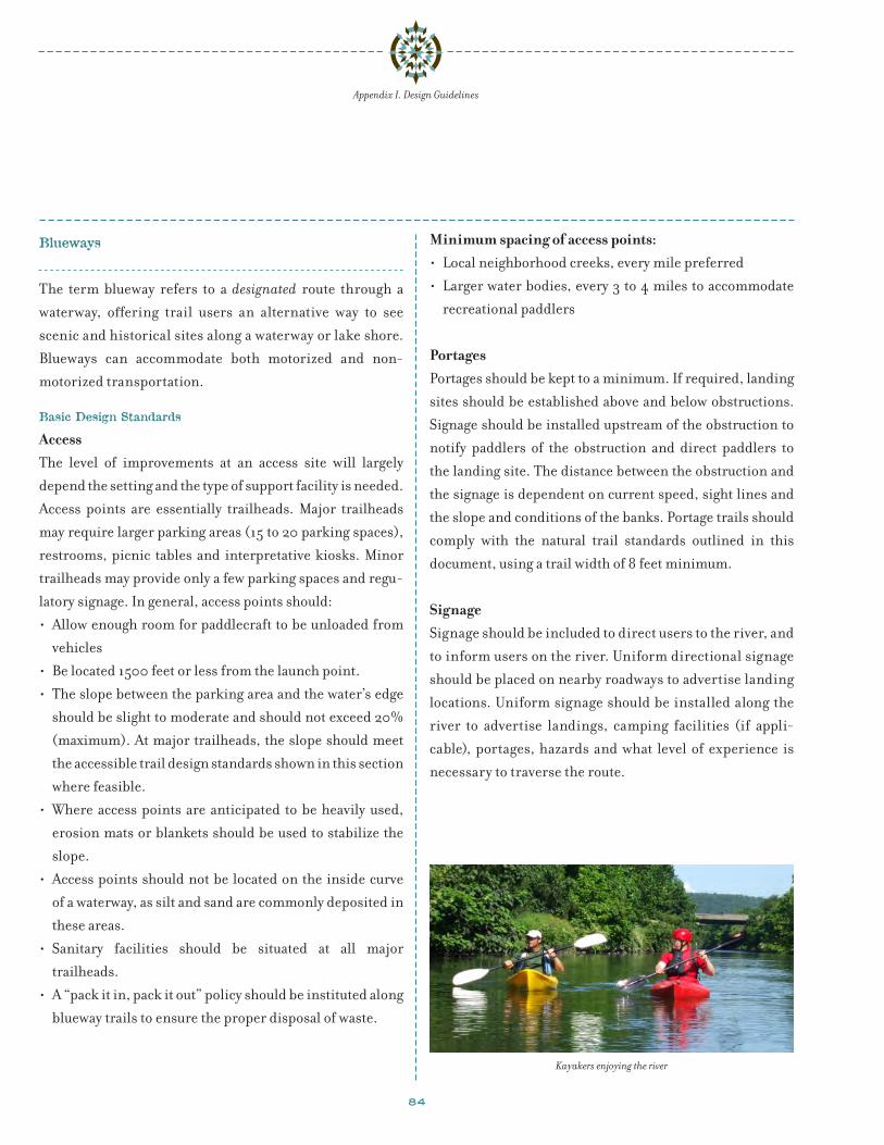
84
Blueways
The term blueway refers to a designated route through a
waterway, offering trail users an alternative way to see
scenic and historical sites along a waterway or lake shore.
Blueways can accommodate both motorized and non-
motorized transportation.
Basic Design Standards
AccessThe level of improvements at an access site will largely
depend the setting and the type of support facility is needed.
Access points are essentially trailheads. Major trailheads
may require larger parking areas (15 to 20 parking spaces),
restrooms, picnic tables and interpretative kiosks. Minor
trailheads may provide only a few parking spaces and regu-
latory signage. In general, access points should:
• Allow enough room for paddlecraft to be unloaded from
vehicles
• Be located 1500 feet or less from the launch point.
• The slope between the parking area and the water’s edge
should be slight to moderate and should not exceed 20%
(maximum). At major trailheads, the slope should meet
the accessible trail design standards shown in this section
where feasible.
• Where access points are anticipated to be heavily used,
erosion mats or blankets should be used to stabilize the
slope.
• Access points should not be located on the inside curve
of a waterway, as silt and sand are commonly deposited in
these areas.
• Sanitary facilities should be situated at all major
trailheads.
• A “pack it in, pack it out” policy should be instituted along
blueway trails to ensure the proper disposal of waste.
Appendix I. Design Guidelines
Minimum spacing of access points:• Local neighborhood creeks, every mile preferred
• Larger water bodies, every 3 to 4 miles to accommodate
recreational paddlers
PortagesPortages should be kept to a minimum. If required, landing
sites should be established above and below obstructions.
Signage should be installed upstream of the obstruction to
notify paddlers of the obstruction and direct paddlers to
the landing site. The distance between the obstruction and
the signage is dependent on current speed, sight lines and
the slope and conditions of the banks. Portage trails should
comply with the natural trail standards outlined in this
document, using a trail width of 8 feet minimum.
SignageSignage should be included to direct users to the river, and
to inform users on the river. Uniform directional signage
should be placed on nearby roadways to advertise landing
locations. Uniform signage should be installed along the
river to advertise landings, camping facilities (if appli-
cable), portages, hazards and what level of experience is
necessary to traverse the route.
Kayakers enjoying the river
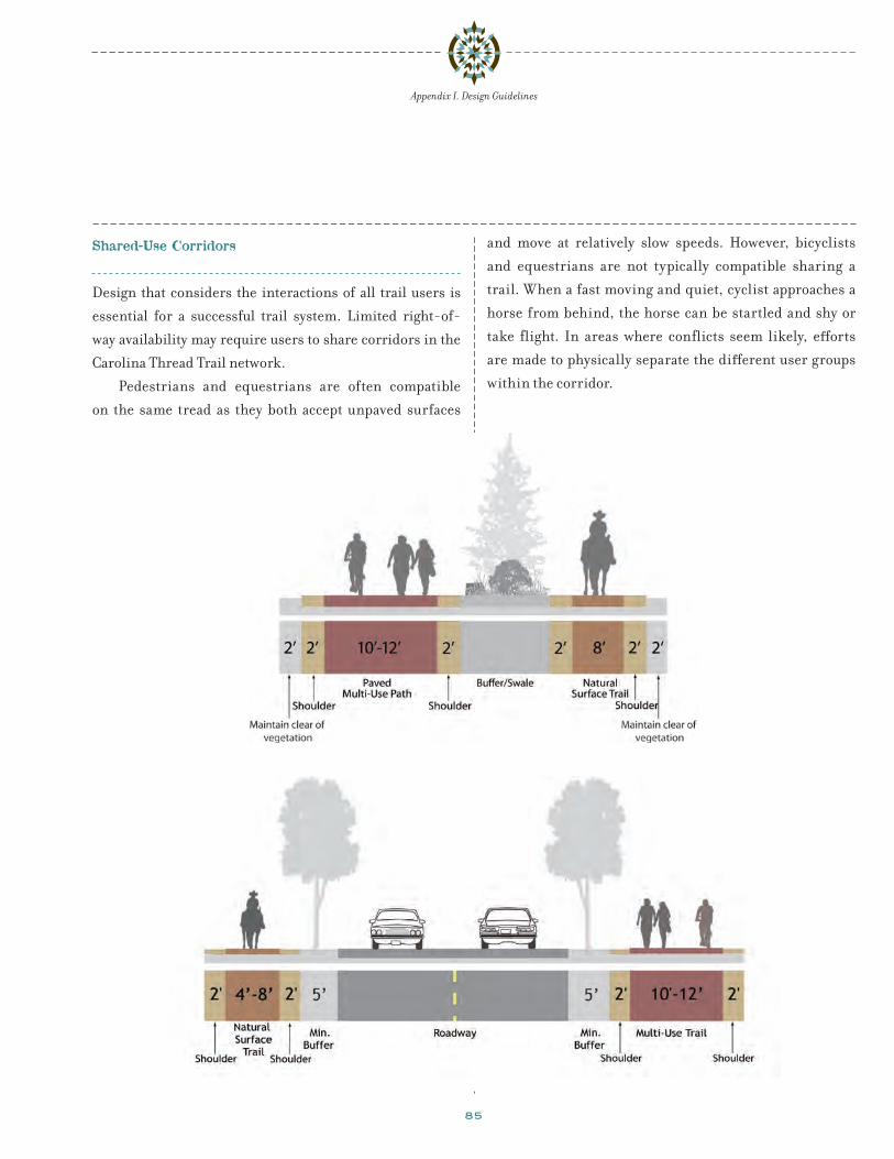
85
Appendix I. Design Guidelines
Shared-Use Corridors
Design that considers the interactions of all trail users is
essential for a successful trail system. Limited right-of-
way availability may require users to share corridors in the
Carolina Thread Trail network.
Pedestrians and equestrians are often compatible
on the same tread as they both accept unpaved surfaces
and move at relatively slow speeds. However, bicyclists
and equestrians are not typically compatible sharing a
trail. When a fast moving and quiet, cyclist approaches a
horse from behind, the horse can be startled and shy or
take flight. In areas where conflicts seem likely, efforts
are made to physically separate the different user groups
within the corridor.

86
Appendix I. Design Guidelines
ac ce s si bl e t r a i l de sign
General guidelines have been created in response to the
American with Disabilities Act (ADA) for accessible trails.
Constructing outdoor trails may have limitations that make
meeting ADA guidelines difficult and sometimes prohibi-
tive. Prohibitive impacts include: harm to significant
cultural or natural resources, a significant change in the
intended purpose of the trail, requirements of construction
methods that are against federal, state or local regulations,
or terrain characteristics that prevent compliance. The
following standards serve to accommodate persons with
disabilities in feasible situations.Non-paved surfaces can meet the needs of users with
disabilities when properly constructed
Table 16: Accessible Trail Design StandardsTrail Surface Hard surface such as, asphalt, concrete, wood,
compacted gravelProvide smooth surface that accommodates wheelchairs
Trail Gradient Less than 5% maximum without landings
Less than 8.33% maximum with landings
Greater than 5% is too strenuous for wheelchair users
Trail Cross Slope 2% maximum Provide positive trail drainage, avoid excessive gravitational pull to side of trail
Trail Width 5’ minimum Accommodate a wide variety of users and allows for the passage of two wheelchairs
Trail Amenities, phones, drinking fountains and pedestrian- actuated buttons
Place no higher than 4’ off ground Provide access within reach of wheelchair users
Detectable pavement changes at curb ramp approaches
Place at top of ramp before entering roadways Provide visual and/or tactile queues for visually impaired users
Trailhead Signage Accessibility information such as trail gradient/profile, distances, tread conditions, location of drinking fountains and rest stops
User convenience and safety
Parking Provide at least one accessible parking area per every 25 vehicles spaces at each trailhead
User convenience and safety
Rest Areas On trails specifically designated as accessible, provide rest areas or widened areas on the trail optimally at every 300 feet
User convenience and safety

87
Appendix I. Design Guidelines
t r a i l a n d r o a d wa y cr o s si ng s
Trail / Roadway Crossings
It is highly desirable to minimize the number of potential
vehicle-trail user conflicts. As a general rule, when roadway
crossings are required, they should occur at established
pedestrian crossings, or at locations completely away from
the influence of intersections.
Trail approaches at roadways should always have
Stop or Yield signs to minimize conflicts with autos.
Bike crossing stencils may be placed in advance of trail
crossings to alert motorists. Curb ramps should be
designed to accommodate the range and number of users.
When considering a proposed off-street multi-use
path and required at-grade crossings of roadways, it is
important to remember two items: 1) trail users will be
enjoying an auto-free experience and may enter into an
intersection unexpectedly; and 2) motorists may not
anticipate bicyclists riding out from a perpendicular trail
into the roadway. However, in most cases, an at-grade trail
can be properly designed to a reasonable degree of safety
and meet existing traffic engineering standards.
Evaluation of multi-use trail crossings should involve
an analysis of vehicular traffic patterns, as well as the
behavior of trail users. This includes traffic speeds,
street width, traffic volumes (average daily traffic and
peak hour traffic), line of sight, and trail user profile (age
distribution, range of mobility, destinations). A traffic
safety study should be conducted as part of the actual civil
engineering design of the proposed crossings to determine
the most appropriate design features. This study would
identify the most appropriate crossing options given
available information, which must be verified and/or
refined through the actual engineering and construction
document stage.
Type 1: Unprotected/Marked Crossings
An unprotected crossing (Type 1) consists of a crosswalk,
signing, and often no other devices to slow or stop traffic.
The approach to designing crossings at mid-block loca-
tions depends on an evaluation of vehicular traffic, line of
sight, trail traffic, use patterns, vehicle speed, road type
and width, and other safety issues such as the proximity of
schools. Unprotected crossings may be acceptable when the
following thresholds are met:
Install crosswalks at all trail-roadway crossings
Maximum traffic volumes:
• Up to 15,000 ADT on two-lane roads, preferably with a
median.
cr o s si ng p r o t o t y p e sIntersection approaches are based on established
standards, published technical reports, and the expe-
riences from existing facilities. Virtually all crossings
fit into one of four basic categories:
Type 1: Unprotected/Marked
• Unprotected/marked crossings include trail
crossings of residential, collector, and sometimes
major arterial streets or railroad tracks.
Type 2: Route Users to Existing Intersection
• Trails that emerge near existing intersections may
be routed to these locations, provided that sufficient
protection is provided at the existing intersection.
Type 3: Signalized/Controlled
• Trail crossings that require signals or other control
measures due to traffic volumes, speeds, and trail
usage.
Type 4: Grade-Separated
• Bridges or under-crossings provide the maximum
level of safety but also generally are the most
expensive and have right-of-way, maintenance, and
other public safety considerations.

88
crossings are simply part of the existing intersection and
are not a significant obstacle for trail users.
Type 3: Signalized/Controlled Crossings
New signalized crossings are recommended for crossings
more than 250 feet from an existing signalized intersection
and where the 85th percentile of travel speeds are 40 mph
and above and/or average daily traffic counts (ADT) exceeds
15,000 vehicles. Each crossing, regardless of traffic speed or
volume, requires additional review by a registered engineer
to identify sight lines, potential impacts on traffic progres-
sion, timing with adjacent signals, capacity and safety.
Trail signals are normally activated by push buttons,
but also may be triggered by motion detectors or weight
sensors. The maximum delay for activation of the signal
Appendix I. Design Guidelines
• Up to 12,000 ADT on four-lane
Maximum travel speed
• 35 mi/h
Minimum line of sight:
• 25 mi/h zone: 250 feet
• 35 mi/h zone: 350 feet
• 45 mi/h zone: 450 feet
On two lane residential and collector roads below
15,000 ADT with average vehicle speeds of 35 mph or less,
crosswalks and warning signs (“Bike Xing”) should be
provided to warn motorists, and stop signs and slowing
techniques (bollards/geometry) should be used on the
trail approach. Care should be taken to keep vegetation and
other obstacles out of the sight line for motorists and trail
users. Engineering studies should be done to determine
the appropriate level of traffic control and design.
A flashing yellow beacon or embedded pavement
lights, may be used with a marked crosswalk, preferably
one that is activated by the trail user rather than operating
continuously. Some jurisdictions have successfully
used flashing lights activated by motion detectors on
the trail, triggering the lights as trail users approach
the intersection. This equipment, while slightly more
expensive, informs motorists about the presence of trail
users. This type of added warning would be especially
important at locations with restricted sight distance.
Type 2: Route Users to Existing Intersection
Crossings within 250 feet of an existing signalized intersec-
tion with pedestrian crosswalks are often diverted to the
signalized intersection for safety purposes. For this option
to be effective, barriers and signs may be needed to direct
trail users to the signalized crossings. In most cases, signal
modifications would be made to add pedestrian detection
and to comply with ADA recommendations. In many cases,
such as on most community trails parallel to roadways,
Type 1 crossing improvements are recommended at trail intersections with major roads.
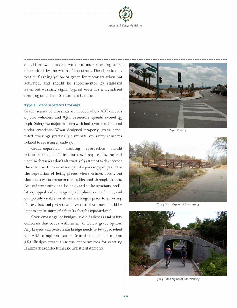
89
Appendix I. Design Guidelines
should be two minutes, with minimum crossing times
determined by the width of the street. The signals may
rest on flashing yellow or green for motorists when not
activated, and should be supplemented by standard
advanced warning signs. Typical costs for a signalized
crossing range from $150,000 to $250,000.
Type 4: Grade-separated Crossings
Grade-separated crossings are needed where ADT exceeds
25,000 vehicles, and 85th percentile speeds exceed 45
mph. Safety is a major concern with both overcrossings and
under-crossings. When designed properly, grade-sepa-
rated crossings practically eliminate any safety concerns
related to crossing a roadway.
Grade-separated crossing approaches should
minimize the out-of-direction travel required by the trail
user, so that users don’t alternatively attempt to dart across
the roadway. Under-crossings, like parking garages, have
the reputation of being places where crimes occur, but
these safety concerns can be addressed through design.
An undercrossing can be designed to be spacious, well-
lit, equipped with emergency cell phones at each end, and
completely visible for its entire length prior to entering.
For cyclists and pedestrians, vertical clearance should be
kept to a minimum of 8 feet (12 feet for equestrians).
Over-crossings, or bridges, avoid darkness and safety
concerns that occur with an at- or below-grade option.
Any bicycle and pedestrian bridge needs to be approached
via ADA compliant ramps (running slopes less than
5%). Bridges present unique opportunities for creating
landmark architectural and artistic statements.
Type 4 Grade-Separated Overcrossing
Type 3 Crossing
Type 4 Grade-Separated Undercrossing

90
Appendix I. Design Guidelines
MUTCD example of signing and marking for shared-use path / railroad crossing
Railroad Crossings
The preferred Carolina Thread Trail alignment may include
at-grade crossings of the railroad tracks. New pedestrian
railroad crossing flashers are typically not required for
sidewalk crossings at legal crossings as they are redundant
with adjacent vehicle crossing warning equipment.
Efforts should be made to have multi-use trails cross
railroad tracks at as close to a 90 degree angle as possible.
As crossing angles deviate from perpendicular angles,
possibilities increase for a bicycle wheel to become trapped
in the flangeway, or for cyclists to lose traction on wet rails.
AASHTO guidelines do not specify a minimum crossing
angle; however, they do recommend that any crossing that
is less than a 45 degree angle should be accompanied by a
widening in the trail or shoulder area in order to permit
a cyclist to cross the track at a safer angle, preferably
perpendicular.
Standard concrete railroad crossings with
compressible flangeway fillers permit rail operations
while creating a smooth or subtle bump for cyclists.
Crossing materials should be skid resistant. Colored
surfaces also help alert cyclists to potential conflict points.
Rubber and concrete materials require less maintenance
and have a longer lifespan than wood or asphalt.
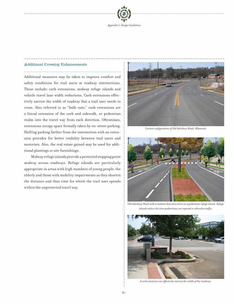
91
Appendix I. Design Guidelines
A curb extension can effectively narrow the width of the roadway.
Current configuration of Old Salisbury Road, Albemarle
Old Salisbury Road with a median that also serves as a pedestrian refuge island. Refuge
islands reduce the time pedestrians are exposed to vehicular traffic.
Additional Crossing Enhancements
Additional measures may be taken to improve comfort and
safety conditions for trail users at roadway intersections.
These include: curb extensions, midway refuge islands and
vehicle travel lane width reductions. Curb extensions effec-
tively narrow the width of roadway that a trail user needs to
cross. Also referred to as “bulb-outs,” curb extensions are
a literal extension of the curb and sidewalk, or pedestrian
realm into the travel way from each direction. Oftentimes,
extensions occupy space formally taken by on-street parking.
Shifting parking farther from the intersection with an exten-
sion provides for better visibility between trail users and
motorists. Also, the real estate gained may be used for addi-
tional plantings or site furnishings.
Midway refuge islands provide a protected stopping point
midway across roadways. Refuge islands are particularly
appropriate in areas with high numbers of young people, the
elderly and those with mobility impairments as they shorten
the distance and thus time for which the trail user spends
within the unprotected travel way.
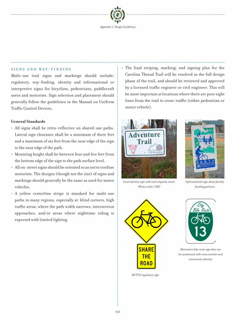
92
Appendix I. Design Guidelines
signs a n d wa y-f i n di ngMulti-use trail signs and markings should include:
regulatory, way-finding, identity and informational or
interpretive signs for bicyclists, pedestrians, paddlecraft
users and motorists. Sign selection and placement should
generally follow the guidelines in the Manual on Uniform
Traffic Control Devices.
General Standards• All signs shall be retro-reflective on shared-use paths.
Lateral sign clearance shall be a minimum of three feet
and a maximum of six feet from the near edge of the sign
to the near edge of the path.
• Mounting height shall be between four and five feet from
the bottom edge of the sign to the path surface level.
• All on-street signs should be oriented so as not to confuse
motorists. The designs (though not the size) of signs and
markings should generally be the same as used for motor
vehicles.
• A yellow centerline stripe is standard for multi-use
paths in many regions, especially at: blind corners, high
traffic areas, where the path width narrows, intersection
approaches, and/or areas where nighttime riding is
expected with limited lighting.
• The final striping, marking, and signing plan for the
Carolina Thread Trail will be resolved in the full design
phase of the trail, and should be reviewed and approved
by a licensed traffic engineer or civil engineer. This will
be most important at locations where there are poor sight
lines from the trail to cross-traffic (either pedestrian or
motor vehicle).
MUTCD regulatory sign
Alternative bike route sign that can
be customized with route number and
community identity
Local identity sign with trail etiquette insert.
(Photo credit: URS)
Informational sign about facility
funding partners

93
Appendix I. Design Guidelines
Regulatory
Regulatory signs should state the rules and regulations
associated with trail usage, as well as the managing agency,
organization or group. The purpose of trail regulations is
to promote user safety and enhance the enjoyment of all
users. It is imperative that before the trail is opened, trail
use regulations are developed and posted at trailheads and
key access points. Trail maps and informational materials
might include these regulations as well. Establishing that
the trail facility is a regulated traffic environment just like
other public rights of way is critical for compliance, and
often results in a facility requiring minimal enforcement.
Be sure to have an attorney review the trail regulations for
consistency with existing ordinances and enforceability. In
some locations, it may be necessary to pass additional ordi-
nances to implement trail regulations.
Below is a sample of the most common items that should be
covered in trail regulations:
• Hours of use
• Motorized vehicles, other than power-assisted
wheelchairs, are prohibited
• Keep to the right except when passing
• Yield to on-coming traffic when passing
• Bicyclists yield to pedestrians
• Give an audible warning when passing
• Pets must always be on short leashes
• Travel no more than two abreast
• Alcoholic beverages are not permitted on the trail
• Do not wander off of trail onto adjacent properties
In addition, other warning signs informing users of
approaching intersections and crossings of driveways will
need to be installed.
MUTCD sign for narrow travel lanes that
require sharing
A MUTCD approved combined
pedestrian and bicycle trail
crossing sign

94
Information Kiosk
Appendix I. Design Guidelines
Way-Finding and Identity
A comprehensive sign system makes a trail system memo-
rable. Informational kiosks with maps at trailheads and
other pedestrian generators can provide enough infor-
mation for someone to use the trail system with little
introduction. A trail way-finding map typically includes:
current location, nearby destinations and prominent
natural and built features.
Trail legibility and identity is enhanced by having
a consistent, unique logo or design that will help guide
people to and on the trail. Gateways or entry markers at
major access points with trail identity information further
augments the trail experience. They should be visually
clear and distinctive while maintaining consistency with
other sign features found on the trail.
Clear, pedestrian-scaled, signs and markers will
aid in way-finding and separation of user groups. Signs
should be consolidated to avoid clutter and sign fatigue. In
addition to a trail logo being posted on bollards, gates and
at the trailheads, way-finding markers and signs should
be placed at key decision points. Distances may also be
marked periodically so that trail users who wish to pace
themselves have a means of doing so.
Informational and Interpretive
Interpretive installations and signs enhance the trail experi-
ence by providing information about the history, environ-
ment and culture of the area. Installations may provide edu-
cational information while creating a unique and memorable
experience. Interpretive signs should use similar materials,
forms and colors as other sign elements found throughout
the trail in order to provide a unified trail experience.

95
Appendix I. Design Guidelines
Trail Etiquette
Informing trail users of acceptable trail etiquette is a
common issue when multiple user types are anticipated.
Yielding the right-of-way is a courtesy and yet a neces-
sary part of a safe trail experience involving multiple trail
users. Trail right-of-way information should be posted at
trail access points and along the trail. The message must
be clear and easy to understand. The most common trail
etiquette systems involve yielding of cyclists to pedes-
trians and equestrians and the yielding of pedestrians to
equestrians. The education of trail users is a critical part
of creating a safe trail environment for all trail users. Not
everyone understands the innate flight sense of a horse.
Guidelines should be clearly posted at trail access points.
Education curriculums, similar to the “Safe Routes to
Schools” Programs, could be used to encourage safe prac-
tices around equestrians on the trail.
User etiquette sign for a bridge
A commonly used multi-use
trail etiquette sign
Trail etiquette signage advises trail
users about proper interactions to
minimize conflicts.

96
User Conflict Reduction Strategies
There are many means of separating trail users including:
time, distance, screening, and barriers. Time separation
applies when different user groups are expected to use
a corridor at different times of the day or week (such as
cyclists during weekday commute hours and equestrians
during evenings or weekends only).
In corridors where adequate right-of-way is available,
trail users may be separated by physical space. Vegetated
buffers or barriers have successfully been used in many
trail scenarios. Elevation changes are another means of
effectively physically and visually separating different
use corridors. Differing surfaces suitable to each user
group, also help foster visual separation and clarity of
where each user group should be. When trail corridors
are constrained, the approach is often to locate the two
different trail surfaces side by side with no separation.
Oftentimes, an expanded trail shoulder serves the role of
the equestrian facility.
When barriers are considered necessary to
separate user types, options include: vegetation, walls,
fences, railings and bollards. The accepted height for
most equestrian barriers is 54 inches. Solid barriers
significantly limit an animal’s peripheral vision and sense
of security and thus are not recommended. When solid
walls are necessary, vegetation should be used to soften
the structure’s appearance.
Railings or safety barriers are recommended when a
trail occurs within six feet of a steep slope (more than 3:1)
with a vertical grade change or drop off of more than 30
inches.
An example of a trail system that clearly separates trail users
A motorized vehicle barrier that allows for equestrian passage
Appendix I. Design Guidelines

97
Appendix I. Design Guidelines
Trailheads
Clearly defined trail access points are crucial to making
trails inviting. Trail access points should provide the
appropriate facilities to accommodate the permitted user
types and expected user volumes. The graphic below
is an example of a major trailhead access point to a trail
that allows hikers, equestrians and bikers. This trail also
provides ADA access as indicated by the accessible parking
stall nearest the entrance.
Trailheads should:
• Provide signage displaying permitted uses, regulations
and emergency contact information
• Provide wayfinding and informational signage
• Provide the appropriate number of automobile, bike,
and horse parking stalls based on the expected user
volume
• For major trail heads, provide restrooms and drinking
fountains
A major trailhead that accommodates equestrians

98
t r a i l a m e n i t i e sTrails with high user volumes, particularly those that access
a destination point and drive-in access, should provide
amenities to support users. Amenities include trash and
recycling receptacles, benches, restrooms, and an infor-
mational kiosk. Trails that restrict biker or equestrian use
should provide parking stalls for bikes and horses at their
entrances.
Seating and Tables
Providing benches at key rest areas and other appropriate
locations encourages people of all ages to use the trail by
ensuring that they have a place to rest along the way. Benches
can be simple with wood slates or more ornate with stone,
wrought iron, and concrete. Benches should ideally utilize
shady areas to provide trail users relief from the sun. Tables
provide picnicking opportunities and should be installed in
easily accessible areas near trailheads and parks. This will
encourage both trail users and non-trail users to picnic.
Trash receptacles should be installed accordingly.
Drinking Fountains
Drinking fountains provide relief to trail users and their
pets. They should be installed in combination with seating
where the topography requires extra exertion from the trail
user. A spigot can be installed at lower levels, with a catch
basin for watering dogs.
Trash Receptacles
Trash and dog waste receptacles help encourage trail users
to keep the trail and trailheads free from debris. It is
recommended that both types of receptacles be placed at
trailheads and key access points along the trail. However,
the National Park Service’s ethic of “pack it in, pack it out”
should be encouraged.
Bicycle Parking
Bicycle parking allows trail users to safely park their bicy-
cles if they wish to stop along the way or leave their bicycle
at trailheads while they hike. Bicycle parking may be
installed at trailheads, bicycle trail intersections with trails
that prohibit bicycle use, and at popular destinations along
a trail.
Lighting
Lighting improves the safety of the trail or path user by
increasing visibility during non-daylight hours. Lighting
should consider the surrounding land use to minimize
light pollution in unwanted areas such as residential areas.
Lighting fixtures should be pedestrian scale and installed
near benches, drinking fountains, bicycle racks, trailheads,
and roadway crossings. Lighting is typically most appro-
priate along Class I multi-use paths used for transportation
purposes.
Appendix I. Design Guidelines
Clockwise from top left: Pedestrian-scaled lighting along a paved path; bicycle racks
encourage bicycle use; shaded seating increases trail users comfort and encourages trail
use; seating and trash receptacle surround made from wood.

99
Appendix I. Design Guidelines
p u bl ic a r tPublic art along a trail provides an opportunity to add
interest to the trail experience and, depending on the
scale and form, can become an “event” in itself and serve
as a public draw. Public art can be aesthetic or functional,
doubling as sitting or congregation areas. Local artists
should be encouraged to produce artwork in a variety of
materials for sites along the Carolina Thread Trail corridor
that reflect the communities in Stanly County.
Interpretive panels on a decorative wall
Art installation on a retaining wall
Art installation along a trail in Lincoln, Nebraska
Art installation on a bikeway

100
erosion on sustainable trails. A general rule-of-thumb is
to incorporate a grade reversal every 20 to 50 linear feet
along the trail to divide the trail into smaller watersheds
so the drainage characteristics from one section won’t
affect another section. Water flowing along a segment of
trail that is deeply compacted will be trapped on the trail a
short distance before it can drain.
Grade reversals have the added benefit of adding
interest to any trail. All trail users appreciate the short
downhill break during a long climb, or the opportunity to
‘let off their brakes’ for a bit during a long downhill trek.
Rolling grade and grade
reversals are preferred
to other mechanical
methods of routing
water off of trails such as
water bars, check dams
and culverts because
they do not present a
barrier to users.
dr a i n age a n d e r o sion c on t r olErosion control is necessary to maintain a stable walkway
and trail surface. Following land contours helps reduce
erosion problems, minimizes maintenance and increases
comfort levels on all trail types.
Paved Surfaces: A 2% cross slope will resolve most
drainage issues on a paved path and should be used for
both the trail and its shoulders. A maximum 1:6 slope may
be used for the shoulders although 2% is preferred. For
sections of cut where uphill water is collected in a ditch and
directed to a catch basin, water should be directed under
the trail in a drainage pipe of suitable dimensions. Per
NCRA guidelines, water should always be directed away
from rail tracks. During trail construction, local erosion
control best practices should be followed.
Natural Surfaces: Erosion will occur on natural
surface trails. Natural surface trails should be designed
to accommodate erosion by shaping the tread to limit how
much erosion occurs and to maintain a stable walkway and
trail surface. The goal is to outslope the trail so that water
sheets across, instead of down, its tread. Even the most
well built trails will break down over time from forces
such as compaction and displacement.
Designing trails with rolling grades is the preferred
way to build sustainable natural surface trails. “Rolling
grade” describes the series of dips, crests, climbs and
drainage crossings linked in response to the existing
landforms on the site to form a sustainable trail. The
tread of the trail must be able to drain to a point lower
than the trail at all times. When a natural rolling grade
cannot be developed, grade reversals (sometimes known
as grade dips, grade breaks, drain dips or rolling dips)
are constructed to create trail undulations. Frequent
grade reversals (grade dips, grade brakes, drain dips
or rolling dips) are a critical element for controlling Water erosion undercuts an asphalt trail surface, posing a safety issue for trail users
and costly maintenance repairs.
Debris on an asphalt paved trail due to
improper drainage design
Appendix I. Design Guidelines

101
a p p e n di x ii:m a i n t e n a nce a n d m a n age m e n t
Trail Maintenance
Effective trail maintenance is critical to the overall
success and safety of any trail system. Maintenance activi-
ties typically include: pavement stabilization, landscape
maintenance, facility upkeep, sign replacement, pruning,
litter removal and painting. A successful maintenance
program requires continuity and often involves a high
level of citizen participation. Routine maintenance on
a year-round basis will not only improve trail safety, but
will also prolong the life of the trail. The benefits of a good
maintenance program are far-reaching, including:
• A high standard of maintenance is an effective
advertisement to promote the trail as a local and regional
recreational resource.
• Good maintenance can be an effective deterrent to
vandalism, litter, and encroachments.
• A regular maintenance routine is necessary to preserve
positive public relations between the adjacent land
owners and managing agency.
• Good maintenance can make enforcement of regulations
on the trail more efficient. Local clubs and interest
groups will take pride in “their” trail and will be more
apt to assist in protection of the trail.
• A proactive maintenance policy will help improve safety
along the trail.
Ongoing trail maintenance likely includes some, if
not all, of the following activities:
Inspections
A good maintenance program begins with a means of locat-
ing and identifying problems, such as erosion, vandalism,
safety issues and plant replacement needs. Regular inspec-
tions can also alert staff to sections of trail that may need to
be realigned to avoid on-going repairs in problem spots.
Vegetation
In general, plants should be allowed to grow in their
natural state. Plantings along the trailside should be sited
to maintain visibility between plantings and to avoid
creating the feeling of an enclosed space. This will give
trail users good, clear views of their surroundings, which
enhances the aesthetic experience. Under-story vegeta-
tion within the trail right-of-way should not be allowed
to grow higher than 36 inches. Selection and placement of
trees should minimize vegetative litter on the trail as well
as root uplifting of pavement. Vertical clearance along the
trail should be periodically checked, and any overhanging
branches should be pruned to a minimum vertical clear-
ance of 10 feet (12 feet for equestrians).
Planted vegetation should be inspected during
scheduled maintenance periods (Table 17 on the following
page) to identify plants in need of replacement.
Surfacing
Asphalt
Recommended surface material for the multi-use
segments. Cracks, ruts and water damage will need to be
repaired periodically.
Where drainage problems exist along the trail,
concrete construction and drainage pipes may need to be
installed. Ditches and drainage structures need to be kept
clear of debris to prevent wash outs and maintain positive
drainage flow. Maintenance checks should be conducted
immediately after each storm that causes localized
flooding. Maintenance staff should inspect for erosion of
the trail and trail shoulders. Erosion problems should be
corrected as soon as possible.
The trail surface should be kept free of debris,
especially broken glass and other sharp objects, loose

102
gravel, leaves and stray branches. Trail surfaces should
be swept periodically. Soft shoulders should be well
maintained to maximize their usability. Typical installation
practices include two applications of herbicide when laying
and installing granular surfaces and plant material.
Natural Surface Trails
Light maintenance of natural trails is recommended semi-
annually. Maintenance would include cleaning and servicing
water bars and drains, raking loose rock, tightening signs
and make sure posts are secure and upright. Inspection
during regular light maintenance will assist staff in deter-
mining when heavy maintenance will be required.
Heavy maintenance activities may encompass
installation or repair of drainage systems, re-establishing
the cant of the trail through cut and fill, removing large
embedded rocks and major corridor clearing. A heavy
maintenance schedule will occur as needed.
Pest and Vegetation Management
Basic measures should be taken to protect the trail invest-
ment. This includes a bi-annual pruning along both sides of
the trail to prevent invasion of plants into the pavement and
shoulder areas. The recommended time of year for pruning
is fall and spring. Wherever possible, vegetation control
should be accomplished by mechanical means or hand labor.
Some species may require spot application of state-approved
herbicide.
Litter and Illegal Dumping
Staff or volunteers should remove litter along the trail.
Litter receptacles should be placed at primary access
points such as trailheads.
Illegal dumping should be controlled by vehicle
barriers, regulatory signage and fines as much as possible.
When it does occur, it should be removed as soon as possible
in order to prevent further dumping. Neighborhood
volunteers, friends groups, alternative community service
crews and inmate labor should be considered in addition to
maintenance staff.
Signage
Signs should be replaced along the trail on an as-needed
basis.
Flooding
Portions of trail may be subjected to periodic flooding.
Debris accumulated on the trail surface should be removed
after each recession of water. Debris should be periodically
removed from the waterway under any bridge structure.
Typical maintenance vehicles for the trail will be light
pick-up trucks and occasionally heavy dump trucks and
tractors. A mechanical sweeper is recommended to keep the
trail clear of loose gravel and other debris. Care should be
taken when operating heavier equipment on the trail to warn
trail users and to avoid breaking the edge of the trail surface.
Table 17. Maintenance RecommendationsItem Suggested Frequency
Sign replacement/repair 1-3 years
Pavement marking replacement 1-3 years
Planted Tree, Shrub, trimming/fertilization/replacement
5 months -1 year
Pavement sealing/potholes 5-15 years
Natural surface trails light maintenance Bi-annually
Clean drainage system After a storm event
Pavement sweeping Monthly
Shoulder pruning* Bi-annually (fall/spring)
Trash disposal As needed, twice a week
Graffiti removal Weekly/or as reported
Maintain benches, site amenities 1 year, or as needed
Pruning to maintain vertical clearance 1-4 years
Remove fallen trees As needed
Weed control Monthly
Water plants As needed
* Additional maintenance may be required.
Appendix II. Maintenance and Management
103
Acquiring funding for projects and programs is consid-
erably more likely if it can be leveraged with a variety of
local, state, federal and public and private sources. This
chapter identifies potential matching and major funding
sources available for trail projects and programs as well as
their associated need and criteria.
Private Funding - Private funding from citizens, philan-
thropic organizations, non-profits and local businesses
should be used to build segments of the Stanly County
Greenway system and the Carolina Thread Trail. The
Catawba Lands Conservancy (CLC) is leading a private
fundraising effort to fund to fund trail planning, design,
land acquisition, and construction for local governments
and communities that plan for and adopt greenway master
plans. These grant funds can be supplemented with other
local, private sector monies to support future implemen-
tation of this master plan.
Public Funding - A variety of public funding dollars are
available to support future development of the Stanly
County trails.
• Federal Funding - Federal funding is a key source of
funding for larger or more expensive trail projects.
Some federal funds are direct appropriations to States
and are therefore distributed and managed by a state
agency. Other funds are distributed directly from the
federal program. Federal funding programs described
in greater detail following.
• State Funding - Most state funding for greenway
acquisition and development in North Carolina comes
from NCDOT and trust funds. Local governments must
provide matching funds for many of these sources,
therefore Stanly County should consider establishing
a dedicated, recurring source of revenue for greenway
acquisition and development.
a p p e n di x ii i:o v e r v i e w of f u n di ng op t ions
• Local Funding Options - Local governments generally
use discretionary annual spending (General Fund),
dedicated funding, and debt financing. Funding varies
by community dependent on taxing capacity, budgetary
resources, voter preference, and political will. The
ability to establish dedicated funding sources may also
depend on enabling authority. North Carolina has given
local governments a limited number of options to fund
land conservation and trail projects.
o v e r v i e w of l o c a l f u n di ng op t ions
Revenue Bonds
The county could issue revenue bonds to fund bicycle and/
or pedestrian improvements. This would spread the cost of
the improvements over the life of the bonds. Certain types
of bonds would require voter approval. The debt would
have to be retired, so funding for repayment on the bond
and the interest would be required.
A bond issued in Denver, Colorado funded $5 million
for trail development and also funded the city’s bike
planner for several years. The City of Albuquerque, New
Mexico and Bernalillo County have a 5 percent set-aside
of street bond funds for trails and bikeways. This has
amounted to approximately $1.2 million for the City every
two years.
General Obligation Bonds (GOB)
General obligation bonds are issued with the underlying
belief that a municipality will be able to repay its debt
obligation through taxation or revenue from projects. This
financial commitment does not require assets to be used
as collateral, but is issued as “good faith debt”. A GOB is a
bond sold by a specified jurisdiction to investors to raise

104
money. Typically, money is raised for capital improve-
ment projects and general improvements (i.e. open space
acquisition and/or park and greenway construction); this
depends on the local and state laws which are subject to
change. A GOB requires a referendum approval before it
is issued. This portion of the process is time sensitive as
referenda are approved or denied during election years.
Special Assessment Bonds
A Special Assessment Bond is a special type of municipal
bond used to fund a development project. Interest owed to
lenders is paid by taxes levied on the community benefiting
from the particular bond-funded project. For example, if
a bond of this sort were issued to pay for sidewalks to be
re-paved in a certain community, an additional tax would
be levied on homeowners in the area benefiting from this
project. Area homeowners get nicer walking paths, and
they will probably see the value of their property increase
accordingly, but this comes at a price. Their property taxes
will increase to pay the interest owed to the bondholders
by the municipality. Source: http://www.investopedia.com
State Revolving Bonds
There are a variety of revolving loan funds offered through
the State for water pollution control and environmental
protection. These revolving loan funds are available for
local communities and act similar to revenue bonds which
require upfront revenue repayment sources, limited
repayment terms and low interest rates.
Installment Purchase Agreement (IPA)
An installment purchase agreement is basically a payment
plan to compensate property owners for restrictions on the
future use of their land. IPAs spread out payments so that
landowners receive tax exempt interest over a period up to
30 years. The principal of the sales amount is due at the
end of the agreed upon term thus making the agreement
favorable in terms of property taxes. However, because
installment purchase agreements are essentially long-
term debt, the agreements generally require the same
approvals as general obligation bonds and require a dedi-
cated funding source to be in place (American Farmland
Trust, 2000).
Street User/Street Utility Fees
The County could administer street user fees through
residents’ monthly water or other utility bills. The revenue
generated by the street user fee is used for operations and
maintenance of the street system. Revenue from this fund
could be used to maintain on-street bicycle and pedestrian
facilities, including routine sweeping of bicycle lanes and
other designated bicycle routes. Additionally, this type of
fee may free up more general fund money for off-street
projects. Implementation of street user fees would require
a public vote.
Impact Fee / Developer Contribution
Another potential local source of funding is developer
impact fees, typically tied to trip generation rates and
traffic impacts produced by a proposed project. A devel-
oper may reduce the number of trips (and hence impacts
and cost) by paying for on- and off-site bikeway and
pedestrian improvements that will encourage residents
to bicycle and walk rather than drive. Establishing a clear
nexus or connection between the impact fee and the proj-
ect’s impacts is critical in avoiding a potential lawsuit.
Mitigation Banking
Mitigation banking involves the creation, preservation, or
enhancement of wetlands. This happens only when wetland
losses are unavoidable in advance of development actions,
when the wetland cannot be compensated for within the
development’s parameters, or when the wetland would not
be as environmentally beneficial. It typically involves the
Appendix III. Funding and Financing
105
consolidation of small, fragmented wetland mitigation
projects into one large contiguous site. Units of restored,
created, enhanced or preserved wetlands are expressed as
“credits” which may subsequently be withdrawn to offset
“debits” incurred at a project development site.
Private Individual Donations
Private individual donations can come in the form of
liquid investments (i.e. cash, stock, bonds) or land.
Municipalities typically create funds to facilitate and
simplify a transaction from an individual’s donation to the
given municipality. Donations are mainly received when a
widely supported capital improvement program is imple-
mented. Such donations can improve capital budgets and/
or projects.
Corporate Donations
Corporate donations are often received in the form of
liquid investments (i.e. cash, stock, bonds) and in the form
of land. Municipalities typically create funds to facilitate
and simplify a transaction from a corporation’s donation
to the given municipality. Donations are mainly received
when a widely supported capital improvement program is
implemented. Such donations can improve capital budgets
and/or projects.
Corporate Sponsorships
Corporate sponsorships are often delivered in the form
of services, personnel volunteers, liquid investments
(cash or stock) or land. Municipalities often team with
corporations for necessary and/or alternative funding. A
sponsorship, which is the equivalent of a donation, usually
involves some marketing elements or recognition in one
form or another. The benefits of marketing often improve
the image of the given corporation and are often thought to
benefit both parties.
Foundation Grants
Foundation grants are provided by corporations, individ-
uals, or organizations with a specific mission. The process
involves an application which requires the municipality
to explain the direct relation between the foundation’s
mission and the applicant’s reason for the funding needs.
Foundation grants can offer a wide range of awards
from a thousand dollars to a million dollars. The award
amounts depend on the foundation’s funding capacity and
allocation decision.
Local Grants
Municipalities oftentimes offer a variety of grants, each
with specific purposes. Local grants are limited to areas
within the specific municipality’s border. These grants
range from capital improvement projects to economic
revitalization purposes. The award amounts of these
grants depend on the local municipality’s funding capacity
and allocation decisions. These grants are typically much
lower than federal grants and state grants.
Fundraising / Campaign Drives
Organizations and individuals can participate in a fund-
raiser or a campaign drive. It is essential to market the
purpose of a fundraiser to rally support and financial
backing. Oftentimes fundraising satisfies the need for
public awareness, public education, and financial support.
Land Trust Acquisition and Donation
Land trusts are held by a third party other than the primary
holder and the beneficiaries. This land is oftentimes held
in a corporation for facilitating the transfer between two
parties. For conservation purposes, land is often held in a
land trust and received through a land trust. A land trust
typically has a specific purpose such as conservation and
is used so land will be preserved as the primary holder had
originally intended.
Appendix III. Funding and Financing

106
Greenway Specific Trust Fund
A greenway specific trust fund is a holding company
designated to shelter land for the purpose of greenway
usage. This land should be preserved as intended and is
protected by law. The trust can accept land, funding, or
both. The land can be utilized for the actual greenway or
for a potential land swap, which depends on the donor’s
specifications. Funding can be used for infrastruc-
ture, land acquisition, maintenance, and/or services.
Examples of similarly specific funds can be found in the
North Carolina Natural Heritage Trust Fund (www.ncnhtf.
org) and the North Carolina Agriculture Development and
Farmland Preservation Trust Fund (www.ncadfp.org).
Capital Budget Increase
An increase in the capital budget increases the financial
capacity for capital improvements. This option is rarely
exercised unless there is a specific use for the capital real-
location. Capital budget changes originate in the capacity
of the federal government, state, county, town or city. It
is possible for a jurisdiction to ask for a change in capital
budget from more than one entity to obtain funding for a
project.
Local Budget Yearly Contributions
Local governments may choose to contribute to capital
improvement projects on an annual basis as opposed to a
one-time budget allocation. A funding change such as this
offers a project a financial perpetuity which is a contin-
uous stream of funding. This is especially beneficial when
a project requires additional funding for maintenance,
operations, salaries, or scheduled enhancements.
Tax Increment Financing/Project Development Financing
Tax Increment Financing (TIF) is a tool to use future gains
in taxes to finance the current improvements that will
create those gains. When a public project (e.g., shared-use
path) is constructed, surrounding property values gener-
ally increase and encourage surrounding development or
redevelopment. The increased tax revenues are then dedi-
cated to finance the debt created by the original public
improvement project.
Developer Impact Fees
Another potential local source of funding is developer
impact fees, typically tied to trip generation rates and
traffic impacts produced by a proposed project. A devel-
oper may reduce the number of trips (and hence impacts
and cost) by paying for on- and off-site bikeway and
pedestrian improvements that will encourage residents
to bicycle and walk rather than drive. Establishing a clear
nexus or connection between the impact fee and the proj-
ect’s impacts is critical in avoiding a potential lawsuit.
In Lieu of Fees
Developers often dedicate open space or greenways in
exchange for waiving fees associated with park and open
space allocation requirements in respect to proposed
development. These types of requirements are presented
within local municipal codes and ordinances.
Utility Lease Revenue
A method to generate revenues from land leased to utilities
for locating utility infrastructure on municipally owned
parcels. This can improve capital budgets and support
financial interest in property that would not otherwise
create revenue for the government.
o v e r v i e w of f e de r a l f u n di ng s ou rce s Federal funding is primarily distributed through a
number of different programs established by the Federal
Transportation Act. The latest federal transportation act,
The Safe, Accountable, Flexible, Efficient Transportation
Equity Act – a Legacy for Users (SAFETEA-LU) was
Appendix III. Funding and Financing

107
enacted August 2005, as Public Law 109-59. SAFETEA-LU
authorizes the Federal surface transportation programs
for highways, highway safety, and transit for the five year
period 2005-2009. The current SAFETEA-LU legisla-
tion is in the process of reauthorization. Funding has
been extended until December 2010. It will be important
for Stanly County and the CTT to continue monitoring
the development of new legislation, including federal
stimulus funds,new federal Livability initiatives and the
SAFETEA-LU reauthorization process.
Federal funding is administered through the state
(North Carolina State Department of Transportation) and
regional planning agencies. Most, but not all, of these
funding programs are oriented toward transportation
versus recreation, with an emphasis on reducing auto
trips and providing inter-modal connections. Federal
funding is intended for capital improvements, and safety,
educational programs, and trail projects must relate to the
surface transportation system.
Surface Transportation Act (SAFETEA LU)
On August 10, 2005, the President signed into law the Safe,
Accountable, Flexible, Efficient Transportation Equity
Act: A Legacy for Users (SAFETEA-LU). With guaran-
teed funding for highways, highway safety, and public
transportation totaling $244.1 billion, SAFETEA-LU
represents the largest surface transportation invest-
ment in our Nation’s history. The two landmark bills that
brought surface transportation into the 21st century—the
Intermodal Surface Transportation Efficiency Act of 1991
(ISTEA) and the Transportation Equity Act for the 21st
Century (TEA-21)—shaped the highway program to meet
the Nation’s changing transportation needs. SAFETEA-LU
builds on this firm foundation, supplying the funds and
refining the programmatic framework for investments
needed to maintain and grow our vital transportation
infrastructure.
Source: Federal Highway Administration Office
of Legislation and Intergovernmental Affairs
Program Analysis Team
Enhancements Unit
Department of Transportation
1534 Mail Service Center
Raleigh, NC 2766-1534
Tel: 919-733-2039
Surface Transportation Program – Transportation
Enhancement Activities
The Surface Transportation Program (STP) provides states
with flexible funds which may be used for a wide variety
of projects on any Federal-aid Highway including the
National Highway System, bridges on any public road, and
transit facilities.
Eligible bicycle improvements include on-street
facilities, off-road shared-use paths, sidewalks,
crosswalks, bicycle and pedestrian signals, parking, and
other ancillary facilities. SAFETEA LU also specifically
clarifies that the modification of sidewalks to comply with
the requirements of the Americans with Disabilities Act
is an eligible activity. As an exception to the general rule
described above, STP-funded bicycle facilities may be
located on local and collector roads which are not part of the
Federal-aid Highway System. In addition, bicycle-related
non-construction projects, such as maps, coordinator
positions, and encouragement programs, are eligible for
STP funds.
Source: www.fhwa.dot.gov/environment/te &
www.enhancements.org
Department of Transportation
1534 Mail Service Center
Raleigh, NC 2766-1534
Tel: 919-733-2039
Appendix III. Funding and Financing

108
Federal Lands Highway Program
Federal Lands Highway Program (FLHP) funds may be
used to construct roads and trails within (or, in some cases,
providing access to) Federal lands. FLHP funds total about
$800 million per year. Recreation interests often benefit
from FLHP funds.
There are four categories of FLHP funds: Indian
Reservation Roads, Public Lands Highways, Park Roads
and Parkways, and Refuge Roads. Funds available to the US
Forest Service may be used for forest development roads
and trails. Funds available to the US Fish and Wildlife
Service also may be used for trails (up to 5 percent). To be
eligible for funding, projects must be open to the public
and part of an approved Federal land management agency
general management plan.
FLHP funds appropriated to a Federal land
management agency may be used to pay the non-Federal
share of the cost of any Federal-aid highway project that
provides access to or within Federal or Indian lands.
This allows Federal agencies to use FLHP funds to match
Transportation Enhancement, Recreational Trails, or
Scenic Byways funds.
Source: www.fhwa.dot.gov
Contact: Federal Highway Administration
400 Seventh Street, SW
Washington, DC 20590
Recreational Trails Program (RTP)
The Recreational Trails Program of the Federal
Transportation Bill provides funds to states to develop and
maintain recreational trails and trail-related facilities for
both non-motorized and motorized recreational trail uses.
Examples of trail uses include hiking, bicycling, in-line
skating, equestrian use, and other non-motorized and
motorized uses. These funds are available for both paved
and unpaved trails, but may not be used to improve roads
for general passenger vehicle use or to provide shoulders
or sidewalks along roads.
Recreational Trails Program funds may be used for:
• Maintenance and restoration of existing trails
• Purchase and lease of trail construction and maintenance
equipment
• Construction of new trails, including unpaved trails
• Acquisition or easements of property for trails
• State administrative costs related to this program
(limited to seven percent of a State’s funds)
• Operation of educational programs to promote safety
and environmental protection related to trails (limited
to five percent of a State’s funds)
Source: http://www.fhwa.dot.gov/environment/
rectrails
Contact: Darrell L McBane, State Trails Coordinator
NC Division of Parks & Recreation
MSC 1615
Raleigh NC 27699-1615
Tel: 919-715-8699
Fax :919-715-3085
Email: [email protected]
Surface Transportation Program (STP)
The Surface Transportation Program provides flexible
funding that may be used by States and localities for proj-
ects on any Federal-aid highway, including the National
Highway System, bridge projects on any public road,
transit capital projects, and intracity and intercity bus
terminals and facilities.
Funds are subject to the overall Federal-aid obligation
limitation. Apportioned funds are to be distributed based
on the following factors:
• 25% based on total lane miles of Federal-aid highways
• 40% based on vehicle miles traveled on lanes on
Federal-aid highways
• 35% based on estimated tax payments attributable to
highway users in the States into the Highway Account
Appendix III. Funding and Financing

109
of the Highway Trust Fund (often referred to as
“contributions” to the Highway Account)
The Federal share is generally 80 percent, subject to
the sliding scale adjustment. When the funds are used
for Interstate projects to add high occupancy vehicle or
auxiliary lanes, but not other lanes, the Federal share may
be 90 percent, also subject to the sliding scale adjustment.
Source: www.fhwa.dot.gov
Enhancements Unit
Department of Transportation
1534 Mail Service Center
Raleigh, NC 2766-1534
Tel: 919-733-2039
Highway Safety Improvement Program (HSIP)
This program funds projects designed to achieve signifi-
cant reductions in traffic fatalities and serious injuries on
all public roads, bikeways and walkways. This program
includes the Railway-Highway Crossings Program and the
High Risk Rural Roads Program. This program replaces
the Hazard Elimination Program from TEA-21.
Source: www.fhwa.dot.gov
Enhancements Unit
Department of Transportation
1534 Mail Service Center
Raleigh, NC 2766-1534
Tel: 919-733-2039
National Scenic Byways Program
The National Scenic Byways Program provides for the
designation by the Secretary of Transportation of roads
that have outstanding scenic, historic, cultural, natural,
recreational, and archaeological qualities as All-American
Roads or National Scenic Byways. To be considered for the
designation as an All-American Road or National Scenic
Byway, a road must be nominated by a State, Indian Tribe,
or a Federal land management agency and must first be
designated as a State scenic byway or, in the case of a road
on Indian or Federal land, as a Tribal byway or a Federal
land management agency byway.
The program also provides discretionary grants for
scenic byway projects on All-American Roads, National
Scenic Byways, or State-designated scenic byways, and for
planning, designing, and developing State scenic byway
programs.
The normal Federal share is 80 percent, with a 20
percent non-Federal share required. However, Federal
land management agencies may provide matching funds
for projects on Federal or Indian lands. Projects must be
developed through each State DOT. In making grants,
priority is given to:
• Each eligible project associated with a highway that
has been designated as a National Scenic Byway or All
American Road and that is consistent with the corridor
management plan for the byway;
• Each eligible project along a State designated scenic
byway that is consistent with the corridor management
plan for the byway, or is intended to foster the
development of a plan, and is carried out to make the
byway eligible for designation as a National Scenic
Byway or All American Road; and
• Each eligible project that is associated with the
development of a State scenic byway program or an
activity related to the planning, design, or development
of a State scenic byway program.
Types of improvements include:
• Construction along a scenic byway of a facility for
pedestrians and bicyclists, rest area, turnout, highway
shoulder improvement, passing lane,overlook, or
interpretive facility.
• An improvement to a scenic byway that will enhance
access to an area for the purpose of recreation, including
water-related recreation.
• Protection of scenic, historical, recreational, cultural,
natural, and archaeological resources in an area adjacent
Appendix III. Funding and Financing

110
to a scenic byway.
• Development and provision of tourist information to
the public, including interpretive information about a
scenic byway.
• Development and implementation of a scenic byway
marketing program
Source: http://www.bywaysonline.org/grants/
Contact: Tel: 1-800-429-9297, option 3, option 5
E-mail: [email protected]
Safe Routes to School Program (SRTS)
The purpose of the Safe Routes to Schools (SRTS) program
is to provide children a safe, healthy alternative to riding
the bus or being driven to school. The SRTS Grants were
established to address pedestrian and bicycle mobility and
safety near schools. Application for these funds is open to
any public agency. Agencies providing a funding match
will be given preference.
Eligible projects may include three elements:
• Engineering Improvements. These physical improve-
ments are designed to reduce potential bicycle and
pedestrian conflicts with motor vehicles. Physical
improvements may also reduce motor vehicle traffic
volumes around schools, establish safer and more
accessible crossings, or construct walkways, trails or
bikeways. Eligible improvements include sidewalk
improvements, traffic calming/speed reduction,
pedestrian and bicycle crossing improvements, on-street
bicycle facilities, off-street bicycle and pedestrian
facilities, and secure bicycle parking facilities.
• Education and Encouragement Efforts. These
programs are designed to teach children safe bicycling
and walking skills while educating them about the
health benefits, and environmental impacts. Projects
and programs may include creation, distribution and
implementation of educational materials; safety based
field trips; interactive bicycle/pedestrian safety video
games; and promotional events and activities (e.g.,
assemblies, bicycle rodeos, walking school buses).
• Enforcement Efforts. These programs aim to ensure that
traffic laws near schools are obeyed. Law enforcement
activities apply to cyclists, pedestrians and motor
vehicles alike. Projects may include development of a
crossing guard program, enforcement equipment, photo
enforcement, and pedestrian sting operations.
All projects must be within two miles of primary or middle
schools (K-8). Project proposals are due in early May.
Source: www.fhwa.dot.gov
Enhancements Unit
Department of Transportation
1534 Mail Service Center
Raleigh, NC 2766-1534
Tel: 919-733-2039
High Priority Projects
The High Priority Projects Program provides designated
funding for specific projects identified in SAFETEA-LU.
A total of 5,091 projects are identified, each with a speci-
fied amount of funding over the 5 years of SAFETEA-LU.
[1701] The funds designated for a project in section 1702
are available only for that project with the following excep-
tion: Funds allocated for a project specified below may be
obligated for any other of these projects in the same State:
High Priority Projects listed in section 1702 and numbered
3677 or higher; Projects of National and Regional
Significance listed in section 1301 and numbered 19 or
higher; National Corridor Infrastructure Improvement
Program projects listed in section 1302 and numbered 28
or higher.
The Federal share remains at 80%, except in the States
of Alaska, Montana, Nevada, North Dakota, Oregon, and
South Dakota.
Source: www.fhwa.dot.gov
Enhancements Unit
Appendix III. Funding and Financing

111
Department of Transportation
1534 Mail Service Center
Raleigh, NC 2766-1534
Tel: 919-733-2039
Land and Water Conservation Fund (LWCF)
Land and Water Conservation Fund is a federally funded
program that provides grants for planning and acquiring
outdoor recreation areas and facilities, including trails.
Funds can be used for right-of-way acquisition and
construction.
Grant recipients must provide at least 50% matching
funds in either cash or in-kind contributions. Applications
are to be evaluated in a competitive process by a team of
experts, with criteria developed by a citizen advisory
committee. A portion of Federal revenue is derived
from sale or lease of off-shore oil and gas resources.
The program is administered by the US Department of
the Interior through the National Park Service and the
Intergovernmental Advisory Committee.
Source: http://www.nps.gov/
Contact: Division of Parks and Recreation
Dept. of Environmental and Natural Resources
P.O. Box 27687
Raleigh, NC 27611-7687
Tel: 919-733-4181
Environmental Protection Agency (EPA) -
Environmental Education Grants Program
The Grants Program sponsored by EPA’s Environmental
Education Division (EED), Office of Children’s Health
Protection and Environmental Education, supports envi-
ronmental education projects that enhance the public’s
awareness, knowledge, and skills to help people make
informed decisions that affect environmental quality.
EPA awards grants each year based on funding appropri-
ated by Congress. Annual funding for the program ranges
between $2 and $3 million. More than 75 percent of the
grants awarded by this program receive less than $15,000.
Source: http://www.epa.gov/enviroed/grants.html
Contact: Alice Chastain
U.S. EPA, Region 4
Environmental Education Grants
Office of Public Affairs
61 Forsyth Street SW
Atlanta, GA 30303
Email: [email protected]
Community Block Development Grant Program
(HUD-CBDG)
The Community Development Block Grants program
provides money for streetscape revitalization, which may
be largely comprised of pedestrian improvements. Federal
Community Development Block Grant grantees may use
funds for the following activities:
acquiring real property; reconstructing or rehabilitating
housing and other property; building public facilities and
improvements, such as streets, sidewalks, community and
senior citizen centers and recreational facilities; paying for
planning and administrative expenses, such as costs related
to developing a consolidated plan and managing Community
Development Block Grants funds; provide public services for
youths, seniors, or the disabled; and initiatives such as neigh-
borhood watch programs.
Contact: Greensboro Field Office
Asheville Building
1500 Pinecroft Road, Suite 401
Greensboro, NC 27407-3838
Tel: 336-547-4001 (Field Office Director)
Fax: 336-547-4138
Congestion Mitigation/Air Quality Improvement
Program
The Congestion Mitigation/Air Quality Improvement
Appendix III. Funding and Financing

112
Program (CMAQ) provides funding for projects and
programs in air quality non-attainment and maintenance
areas for ozone, carbon monoxide, and particulate matter
which reduce transportation related emissions. These
federal funds can be used to build bicycle and pedestrian
facilities that reduce travel by automobile.
Eligible bicycle and pedestrian facilities and programs
include:
• Constructing bicycle and pedestrian facilities (paths,
bike racks, support facilities, etc.) that are not exclusively
recreational and reduce vehicle trips
• Non-construction outreach related to safe bicycle use
• Establishing and funding State bicycle/pedestrian
coordinator positions for promoting and facilitating
nonmotorized transportation modes through public
education, safety programs, etc. (Limited to one full-
time position per State)
States may choose to transfer a limited portion of
their CMAQ apportionment to the following Federal-aid
highway programs: Surface Transportation Program (STP),
National Highway System (NHS), Highway Bridge Program
(HBP), Interstate Maintenance (IM), Recreational Trails
Program (RTP), and the Highway Safety Improvement
Program (HSIP).
o v e r v i e w of nor t h c a r ol i n a f u n di ng s ou rce s
North Carolina DOT – Bicycle and Pedestrian Program
The North Carolina General Assembly enacted legislation
(G.S. 136-71.12 Funds) that authorizes the North Carolina
Department of Transportation (NCDOT) to spend any
federal, state, local, or private funds available to the
Department and designated for the accomplishment of
Article 4A, Bicycle and Bikeway Act of 1974. In addition, the
2005 Safe, Accountable, Flexible, Efficient Transportation
Equity Act: A Legacy for Users (SAFETEA-LU) requires
the Department to set aside federal funds from eligible
categories for the construction of bicycle and pedestrian
transportation facilities”
State Construction Funds – State roadway construction
funds (not including the Highway Trust Fund for Urban
Loops and Interchanges) may be used for the construction
of sidewalks and bicycle accommodations that are a part of
roadway improvement projects. Governor’s Highway Safety
Program (GHSP) – GHSP funding is provided through
an annual program, upon approval of specific project
requests, to undertake a variety of pedestrian and bicycle
safety initiatives. Amounts of GHSP funds vary from year
to year, according to the specific amounts requested.
Independent Projects – $6 million is set aside annu-
ally for the construction of bicycle improvements that are
independent of scheduled highway projects in communi-
ties throughout the state. Eighty percent of these funds
are from STP Enhancement funds, while state funds
provide the remaining 20 percent. Currently, $1.4 million
is set aside annually for pedestrian hazard elimination
projects in the 14 NCDOT highway divisions across the
state; $200,000 is allocated to the Division of Bicycle and
Pedestrian Transportation for projects such as training
workshops, pedestrian safety and research projects, and
other pedestrian needs statewide.
Incidental Projects – Bicycle accommodations such as bike
lanes, widened paved shoulders and bicycle-safe bridge
design are frequently included as incidental features
of highway projects. In addition, bicycle-safe drainage
grates are a standard feature of all highway construction.
Most pedestrian safety accommodations built by NCDOT
are included as part of scheduled highway improvement
projects funded with a combination of federal and state
roadway construction funds.
For all the above funding sources contact
www.ncdot.org
Contact: Robert Mosher, Division of Bicycle and
Appendix III. Funding and Financing

113
Pedestrian Transportation
(Mail) 1552 Mail Service Center
(Delivery) 401 Oberlin Road, Suite 250
Raleigh, NC 27605
Raleigh, NC 27699-1552
Tel: 919-807-0777 (Main Office)
Fax 919-807-0768
Email: [email protected]
North Carolina’s Clean Water Management Trust
Fund (CWMTF)
North Carolina’s Clean Water Management Trust Fund
(CWMTF) receives a direct appropriation from the
General Assembly in order to issue grants to local govern-
ments, state agencies and conservation nonprofits to help
finance projects that specifically address water pollution
problems. The 21-member, independent, CWMTF Board
of Trustees has full responsibility over the allocation of
moneys from the Fund.
CWMTF funds projects that:
• Enhance or restore degraded waters;
• Protect unpolluted waters; and/or
• Contribute toward a network of riparian waters.
Source: http://www.cwmtf.net
Contact: Western Piedmont Field Representative:
Bern Schumak
Tel: 336-366-3801
Email: [email protected].
North Carolina Parks and Recreation Trust Fund
(PARTF)
The North Carolina General Assembly established
the Parks and Recreation Trust Fund (PARTF) to fund
improvements in the state’s park system, to fund grants
for local governments and to increase the public’s access
to the state’s beaches. The Parks and Recreation Authority,
an eleven-member appointed board, was also created to
allocate funds from PARTF to the state parks and to the
grants program for local governments.
PARTF is the primary source of funding for building
and renovating facilities in the state parks as well as
for buying land for new and existing parks. The PARTF
program also provides dollar-for-dollar grants to local
governments. Recipients use the grants to acquire land
and/or to develop parks and recreational projects that
serve the general public.
Source: http:// www.partf.net
Contact: John Poole, Program Manager
1615 MSC
Raleigh, NC 27699-1615
Tel: 919-715-2662
Email: [email protected]
North Carolina Farmland Preservation Trust Fund
The North Carolina Farmland Preservation Trust Fund
supports the purchase of agricultural conservation ease-
ments, including transaction costs. Fund public and
private enterprise programs that will promote profitable
and sustainable farms by assisting farmers in devel-
oping and implementing plans for the production of food,
fiber and value-added products, agritourism activities,
marketing and sales of agricultural products produced
on the farm, and other agriculture-related business
activities. The legislation also established a Trust Fund
Advisory Committee to advise Commissioner Troxler on
the prioritization and allocation of funds, the develop-
ment of criteria for awarding funds, program planning,
and other areas for the growth and development of family
farms in North Carolina.
Source: http://www.agr.state.nc.us/paffairs/
farmlandpreservation.htm
Contact: North Carolina Department of Agriculture &
Consumer Services
(Mail) 1001 Mail Service Center
Appendix III. Funding and Financing
114
(Delivery) 2 West Edenton Street, Raleigh, NC 27601
Raleigh, NC 27699-1001
Tel: 919-733-7125
North Carolina Natural Heritage Trust Fund
The North Carolina Natural Heritage Trust Fund provides
funding to select state agencies for the acquisition and
protection of important natural areas, to preserve the
state’s ecological diversity and cultural heritage, and to
inventory the natural heritage resources of the state. The
trust fund is supported by 25% of the state’s portion of the
tax on real estate deed transfers and by a portion of the
fees for personalized license plates. These sources now
generate about $19 million each year. Since its creation,
the trust fund has contributed more than $136 million
through 345 grants to support the conservation of more
than 217,000 acres.
Source: http://www.ncnhtf.org/
Contact: Lisa Riegel, Executive Director
MSC 1601
Raleigh, NC 27699-1601
Tel: 919-715-8014
Fax : 919-715-3060
Email: [email protected]
North Carolina Conservation Income Tax Credit
Program
The Income Tax Credit Program assists land-owners to
protect the environment and the quality of life. A Credit
is allowed against individual and corporate income taxes
when real property is donated for conservation purposes.
Interests in property that promote specific public benefits
may be donated to a qualified recipient. Such conservation
donations qualify for a substantial tax credit.
Source: http://www.enr.state.nc.us/
conservationtaxcredit/
Contact: N.C. Department of Revenue
Tel: 919-733-4684 for individual income taxes
Fax: 919-733- 3166 for corporate income taxes
North Carolina Adopt-A-Trail Grants
The Adopt-A-Trail Grant Program (AAT) awards $108,000
annually to government agencies, nonprofit organiza-
tions and private trail groups for trails projects. The funds
can be used for trail building, trail signage and facilities,
trail maintenance, trail brochures and maps, and other
related uses. This grant requires no local match or in-kind
services.
Source: http://www.ncparks.gov/About/grants/
trailsmain.php
Contact: Darrell McBane
N.C. Division of Parks and Recreation
State Trails Program
1615 Mail Service Center
Raleigh, NC 27699-1615
Tel: 919-715-8699
Email: [email protected]
North Carolina Division of Water Quality -
319 Program Grants
By amendment to the Clean Water Act Section in 1987,
the Section 319 Grant program was established to provide
funding for efforts to curb non-point source (NPS) pollu-
tion, including that which occurs though storm water
runoff. The U.S. Environmental Protection Agency
provides funds to state and tribal agencies, which are
then allocated via a competitive grant process to organiza-
tions to address current or potential NPS concerns. Funds
may be used to demonstrate best management practices
(BMPs), establish Total Maximum Daily Load (TMDL) for
a watershed, or to restore impaired streams or other water
resources. In North Carolina, the 319 Grant Program
is administered by the Division of Water Quality of the
Department of Environment and Natural Resources.
Appendix III. Funding and Financing

115
Each fiscal year North Carolina is awarded nearly 5
million dollars to address non-point source pollution
through its 319 Grant program. Thirty percent of the
funding supports ongoing state non-point source
programs. The remaining seventy percent is made
available through a competitive grants process. At the
beginning of each year (normally by mid-February), the
NC 319 Program issues a request for proposals with an
open response period of three months. Grants are divided
into two categories: Base and Incremental. Base Projects
concern research-oriented, demonstrative, or educational
purposes for identifying and preventing potential NPS
areas in the state, where waters may be at risk of becoming
impaired. Incremental projects seek to restore streams or
other portions of watersheds that are already impaired and
not presently satisfying their intended uses.
State and local governments, interstate and intrastate
agencies, public and private nonprofit organizations, and
educational institutions are eligible to apply for Section 319
monies. An interagency workgroup reviews the proposals
and selects those of merit to be funded.
Source: http://h2o.enr.state.nc.us/nps/Section_319_
Grant_Program.htm
Contact: Mooresville Regional Office
610 East Center Ave
Suite 301
Mooresville, NC 28115
Tel: 704-663-1699
Fax: 704-663-6040
North Carolina Ecosystem Enhancement Program (EEP)
Clean water, clean air and thriving natural habitats
are fundamental indicators of a healthy environment.
Protecting North Carolina’s ecosystems is critical to
maintaining the state’s quality of life, continuing its
economic growth, and ensuring the health and well-being
of its citizens. According to the three-party Memorandum
of Agreement that established the initiative’s procedures
in July 2003, the mission of the Ecosystem Enhancement
Program is to “restore, enhance, preserve and protect the
functions associated with wetlands, streams and riparian
areas, including but not limited to those necessary for the
restoration, maintenance and protection of water quality
and riparian habitats throughout North Carolina.”
EEP provides:
• High-quality, cost-effective projects for watershed
improvement and protection;
• Compensation for unavoidable environmental impacts
associated with transportation infrastructure and
economic development; and
• Detailed watershed-planning and project
implementation efforts within North Carolina’s
threatened or degraded watersheds.
Source: http://www.nceep.net
Contact: MAIN OFFICE
(Mail) 1652 Mail Service Center
Raleigh, NC 27699-1652
(Delivery) 2728 Capital Blvd, Suite 1H 103
Raleigh NC 27604
Tel: 919-715-0476
Fax: 919-715-2219
North Carolina Wetlands Restoration Program
(NCWRP)
Established by the General Assembly in 1996, the North
Carolina Wetlands Restoration Program (NCWRP) is an
innovative, non regulatory initiative to restore wetlands,
streams and nonwetland riparian areas throughout
the state. The Department of Environment and Natural
Resources – Division of Water Quality oversees the
program. The goals of NCWRP are:
• To restore functions and values lost through historic,
current and future wetland and stream impacts.
• To achieve a net increase in wetland acres, functions and
Appendix III. Funding and Financing
116
values in all of North Carolina’s major river basins.
• To provide a consistent approach to address mitigation
that may be required by law when dredging or filling
wetlands, or altering of streams, is authorized.
• To increase the ecological effectiveness of required
wetlands and stream mitigation.
• To promote a comprehensive approach to the protection
of natural resources.
The NCWRP actively seeks land owners who have
restorable wetland, riparian and stream sites.
Source: http://h2o.enr.state.nc.us
Contact: Bonnie Mullen
North Carolina Wetlands Restoration
NCWRP
Tel: 919-733-5208
Urban and Community Forestry Assistance Program
Urban and Community Forestry begins to address
the stewardship of urban natural resources where 80
percent of the Nation lives. Important connections exist
between the quality of life in metropolitan areas and land
consumption associated with sprawl. In addition there
is a strong economic case for conservation of green open
space to guide growth and revitalize city centers and older
suburbs. The Urban and Community Forestry Program
responds to these needs by maintaining, restoring, and
improving the health of urban trees, forests, greens-
paces and sustainable forest ecosystems for more than 70
million acres of America’s urban and community forest
resources. Through these efforts the Program encour-
ages and promotes the creation of healthier, more livable
urban environments across the Nation. The Program
will continue to expand partnerships with non-govern-
mental organizations to restore natural resources in older,
declining cities and towns.
Source: http://www.fs.fed.us/ucf/
Contact: Ed Macie (R-8)
USDA Forest Service
1720 Peachtree Road, NW, Suite 850S
Atlanta, GA 30367
Tel: 404-347-1647
Fax: 404-347-2776
Email: [email protected]
Water Resources Development Grant Program
This program is designed to provide cost-share grants
and technical assistance to local governments throughout
North Carolina. Applications for grants are accepted
for seven purposes: General Navigation, Recreational
Navigation, Water Management, Stream Restoration, Beach
Protection, Land Acquisition and Facility Development for
Water-Based Recreation, and Aquatic Weed Control. There
are two grant cycles per year. The application deadlines are
January 1st and July 1st.
Contact John Sutherland, Jeff Bruton or
Darren England for additional information.
Source: http://www.ncwater.org/Financial_
Assistance/
Contact: NC Division of Water Resources, DENR
1611 Mail Service Center
Raleigh, NC 27699-1611
Tel: 919-733-4064
Fax: 919-733-3558
Blue Cross Blue Shield Mini Grant
The BCBSNC Foundation developed the Mini-Grants cate-
gory in order to provide funding opportunities for counties
that are experiencing greater levels of economic distress.
The Foundation is also interested in supporting smaller
non-profit organizations that provide direct services
within the specified geographic region. Specifically,
funding is restricted to the 85 designated rural counties
across the state. Organizations with an annual operating
budget of less than $500,000 are eligible to apply.
Appendix III. Funding and Financing

117
The BCBSNC Foundation funds programs that align
with its mission and established focus areas. Applicants
in the Mini-Grants category will engage in a competitive
process for funding. The typical range is between $1,500
-$5,000.
Source: http://www.bcbsnc.com/foundation/
minigrants.html
Contact: (Mail) P.O. Box 2291
Durham, NC 27702
Tel: 919-765-7347
Fax: 919-765-2433
Email: [email protected]
Blue Cross Blue Shield Grant
The BCBSNC Foundation funds programs that align with
its mission and established focus areas. Applicants in
the Grants up to $25,000 category, engage in a two-step,
competitive process to identify those projects that meet
all required eligibility criteria and present the most
compelling
case for funding. The typical range is between $5,000
- $15,000.
Source: http://www.bcbsnc.com/foundation/grants.
html#four
Contact: Mailing Address:
P.O. Box 2291
Durham, NC 27702
Tel: 919-765-7347
Fax: 919-765-2433
Email: [email protected]
o v e r v i e w of p r i va t e f u n di ngMany communities have solicited greenway funding
assistance from private foundations and other conser-
vation-minded benefactors. Below are a few examples of
private funding opportunities available in North Carolina.
American Greenways Program
Administered by The Conservation Fund, the American
Greenways Program provides funding for the planning
and design of greenways. Applications for funds can be
made by local regional or state-wide non-profit organiza-
tions and public agencies. The maximum award is $2,500,
but most range from $500 to $1,500. American Greenways
Program monies may be used to fund unpaved trail
development.
Bikes Belong Grant Program
The Bikes Belong Coalition of bicycle suppliers and
retailers has awarded $1.2 million and leveraged an
additional $470 million since its inception in 1999. The
program funds corridor improvements, mountain bike
trails, BMX parks, trails, and park access. It is funded by
the Bikes Belong Employee Pro Purchase Program.
Foundation for the Carolinas
The Foundation provides strategic leadership in the
community by convening stakeholders on critical issues
related to the civic, social, environmental and economic
health of the region. It also assists community leaders
in better understanding the challenges confronting
the region and helps find solutions to many of our most
pressing community issues.
Source: http://www.fftc.org/affiliates/community/nc/
charlotte/
Contact: Foundation For The Carolinas
217 S. Tryon Street
Charlotte, NC 28202.
Tel: 704-973-4500 / 800-973-7244
North Carolina Community Foundation (NCCF)
The North Carolina Community Foundation serves philan-
thropic donors and supports not-for-profit organizations
Appendix III. Funding and Financing

118
throughout North Carolina. The NCCF makes grants from
charitable funds established by individuals, families,
corporations, and non-profit organizations. Donors make
grants from over 800 funds that serve the following areas
of interest:
• Arts and Humanities
• Community Service
• Education
• Environment
• Health
• Historic Preservation
• Religion
• Science
• Social Services
• Youth
Source: http://www.nccommunityfoundation.org/
Contact: 4601 Six Forks Road, Suite 524
Raleigh, North Carolina 27609
Tel: 919-828-4387 / 800-201-9533
Fax: 919-828-5495
The Cinergy Foundation
The Cinergy Foundation places special emphasis on
projects that help communities help themselves. The
Foundation supports local community, civic and lead-
ership development projects. The Cinergy Foundation
also views community foundations as positive vehicles
for sustaining the long-term health of a community and
promoting philanthropic causes. Infrastructure needs by
a community will not be considered.
The Cinergy Foundation supports health and social
service programs which promote healthy life styles and
preventative medical care. United Way campaigns are
included in Health and Social Services funding.
Source: http://www.cinergy.com/foundation/
categories.asp
Contact: Rachelle Caldwell, Manager
Cinergy Foundation
Tel: 513-287-2363 / 800-262-3000 x 2363
The Cinergy Foundation
139 E. Fourth St.; EA029
Cincinnati, Ohio 45202
American Greenways Eastman Kodak Awards
Eastman Kodak, The Conservation Fund, and the National
Geographic Society provide small grants to stimulate
the planning and design of greenways in communities
throughout America. The annual grants program was
instituted in response to the President’s Commission
on Americans Outdoors recommendation to establish
a national network of greenways. Made possible by a
generous grant from Eastman Kodak, the program also
honors groups and individuals whose ingenuity and
creativity foster the creation of greenways. The program
goals include:
• Develop new, action-oriented greenway projects
• Assist grassroots greenway organizations
• Leverage additional money for conservation and
greenway development
• Recognize and encourage greenway proponents and
organizations
Source: http://www.conservationfund.org
Contact: The Conservation Fund
Tel: 703-525-6300
Email: [email protected]
Appendix III. Funding and Financing

119
a p p e n di x i v :s t a k e hol de r a n d f o c u s gr ou p pa r t ici pa n t s
FOCUS GROUP PARTICIPANTS – SEPTEMBER 10, 2009
NAME AFFILIATION(S)
Payne Caulder City of Albemarle Parks & Rec Staff
Oliver Webster City of Albemarle Parks & Rec Staff
Brian Hinson City of Albemarle Parks & Rec Staff
Mandy Vari City of Locust Planning & Zoning
Tim Flieger City of Locust Public Works
Dan Sullivan City of Locust Parks & Recreation
Larry Branch Oakboro Town Administrator
Jay Almond Badin Town Administrator
Wayne Carter Badin Public Works
Deloris Chambers Badin Town Council
Allen, Ray Albemarle City Manager
Jeannette Napier Albemarle City Council
Judy Holcomb Albemarle City Council
Lindsey Dunevant Stanly County Commission; NC RRS
Jenny Allen Stanly County Public Library
Karen Lowder Retired Teacher; Badin Resident
Denise B. Ross Stanly Community College
Jerry Hudson Badin Resident
Daisy Washington Badin Resident
Charles McComas Uwharrie Wheelmen Bicycle Club
Keith Hinson County Resident, Coach, Tennis Enthusiast
Derek Hill County Resident, Basketball Enthusiast
Brett Speight New London Resident, Softball Enthusiast
Brian Taylor Stanly County Safe Kids Coalition
Ron Crawley Stanly County Planning and Zoning Board
Mike Blanton AP&R Advisory Board; Youth Sports Coach
Kathy Odell Pfeiffer University; Stanly Special Olympics
Barrett Eatman NCDOT; Volleyball Enthusiast
Toby Thorpe Albemarle Parks & Recreation Director
Elaine Plowman AP&R Advisory Board
Bob Hinkle Badin Resident

148
New Photo?
Rocky River near Leiby Park, Stanfield (photo: T. Morehead, CTT)
149
1. FHWA. 2006. Federal Highway Administration University Course on Bicycle and Pedestrian Transportation: Student Workbook (second edition). Report No. HRT- 05-133.
2. Haskell, W. L., I. Lee, R. R. Pate, K. E. Powell, S. N. Blair, B. A. Franklin, C. A. Macera, G. W. Heath, P. D. Thompson and A. Bauman. (2007). Physical Activity and Public Health: Updated Recommendation for Adults From the American College of Sports Medicine and the American Heart Association. Circulation: Journal of the American Heart Association, 116, 1081-1093. Dallas: American Heart Association. Retrieved June 4, 2009, from http://circ.ahajournals.org/cgi/reprint/CIRCULATIONAHA.107.185649
3. Transportation Research Board for the National Cooperative Highway Research Program. (2006). Guidelines for the Analysis of Investment in Bicycle Facilities (NCHRP Report 552, Appendix E: User Health Benefits). Washington D.C.: Transportation Research Board. Retrieved June 4, 2009, from: http://onlinepubs.trb.org/Onlinepubs/nchrp/nchrp_rpt_552.pdf
4. Karadeniz, D. (2008). The Impact of the Little Miami Scenic Trail on Single Family Residential Property Values. Unpublished master’s thesis, University of Cincinnati. Retrieved June 2, 2009, from: http://atfiles.org/files/pdf/LittleMiamiPropValue.pdf
5. Los Angeles County Metropolitan Transportation Authority. (2007). Bicycle Paths: Safety Concerns and Property Values. Retrieved July 8, 2009, from: http://www.greenway.org/pdf/la_bikepath_safety.pdf
6. Colorado Dept. of Transportation and the Center for Research in Economic and Social Policy at the Univ. Colorado – Denver. (1999). The Economic Impact of Bicycling in Colorado. Retrieved June 1, 2009, from http://atfiles.org/files/pdf/CObikeEcon.pdf
7. Lawrie, J., J. Guenther, T. Cook, M. P. Meletiou, S. W. O’Brien of the Institute for Transportation Research and Education for the North Carolina Department of Transportation. (2004). The Economic Impact of Investments in Bicycle Facilities: A Case Study of the Northern Outer Banks.
http://www.ncdot.org/transit/bicycle/safety/Economic_Impact_Study_PDFs/OBX%20EIS%20Tech%20Rprt%20Full.pdf
8. Wilbur Smith Associates in association with Buxton Communications and Bicycle Federation of America for Office of Passenger Transportation: Maine Department of Transportation. (April 2001). Bicycle Tourism in Maine: Economic Impacts and Marketing.
9. Center for International Public Management, Inc. for the Florida Dept. of Environmental Protection, Office of Greenways and Trails. (1998). Thinking Green: A Guide to the Benefits and Costs of Greenways and Trails. Retrieved June 1, 2009, from: http://www.dep.state.fl.us/gwt/community/refguide/pdf/thinkgreen.pdf
10. Alta Planning and Design. (September 2008). The Value of the Bicycle-Related Industry in Portland. Retrieved July 13, 2009, from: http://www.altaplanning.com/App_Content/
11 Maas, J., Verheij, R., de Vries, S., Spreeuwenberg, P., Schellevis, F., & Groenewegen, P. (2009). Morbidity is related to a green living environment. Journal of Epidemiology & Community Health , 63 (12), 967-973.
12 Federal Emergency Management Agency. (2005) Building Stronger: State and Local Mitigation Planning
f o o t no t e s

150
Footnotes
151