career clusters geo integrating... · –project management ... –geospatial skills will be...
TRANSCRIPT

Geospatial Technology and Career Clusters
Eddie Hanebuth
Digital Quest
EIGS
MsET
MBA

Geospatial Technology is Problem Solving
• Geospatial Technology is the problem solver of our time.
• Spatial Information as the new weak link
• Just in the past month’s big spatial news stories:– Which Flood gates do we open? (Government & Public Administration)
• How will the closing of I-40 affect supply chains? (Transportation/Logistics)
• Which populations do we evacuate (Law, Public Safety…)
– Where is the AZ Fire spreading? (Multiple Clusters)
– Candidates vying for Iowa and New Hampshire (Gov’t/Marketing)
– Which states will take High Speed Rail funds? (Transportation,Government, Hospitality)
– Where is the German e. coli source? (Health Science/ AGFNR/Transportation)
Geospatial technology helps you to answer How?, Where?, and Why?….
Like……..
How Does Geospatial Technology Impact These Stories and Your Career Clusters?

Where is?
My house The local high school
The Fire Ant PopulationIn the United States
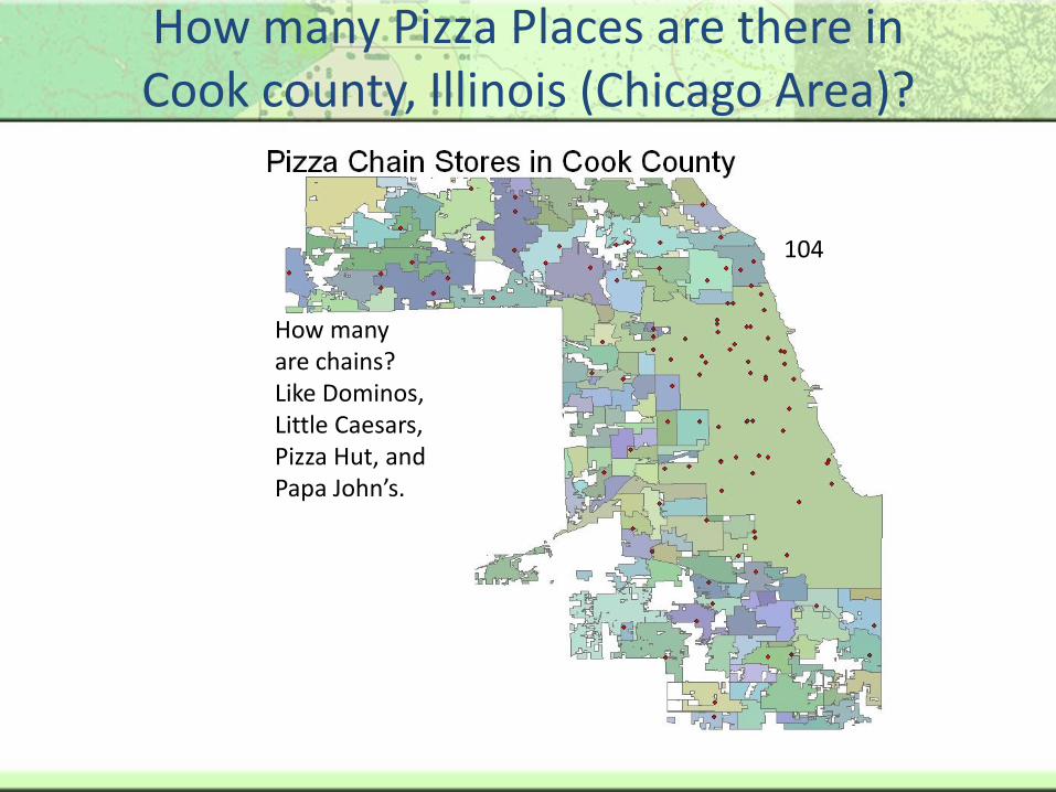
How many Pizza Places are there in Cook county, Illinois (Chicago Area)?
646
How many do you think?
How many are chains?Like Dominos, Little Caesars, Pizza Hut, and Papa John’s.
104

Hard to tell…
Helps you see patterns. Is there a pattern…to the locations of Volcanoes?

Is there a relationship between Education and Income?
Education Level of the residents in Washington, DC… The darker areas represent the more educated residents.
Income Level … again the darker areas represent higher income levels.


What is Geospatial Technology?
• GIS (Geographic Information Systems)
• Remote Sensing
• GPS (Global Positioning System)
• Surveying
GIS
Remote Sensing
Surveying
GPS

Geographic Information System (GIS)
Geographic
Information
System
Dealing with Locations, interactions and distributionof people, places and/or things.
All types of spatial information available for use: people, places, events, databases, images, GPS data
The GIS Operator, the computer, the data, and the software working together.

GIS & The Bigger Picture
• Maps are not new…Why now?
• Companies & Organizations use GIS for 3 Reasons:
1. Decision Making Support - GIS allows these organizations to have spatial databases … pages of charts and spreadsheets become interactive maps
2. Promotes Efficiency – Organizations can see problems before they arise
3. Cost Saving – Effective use of 1 and 2 lead to making the least costly decision the first time.
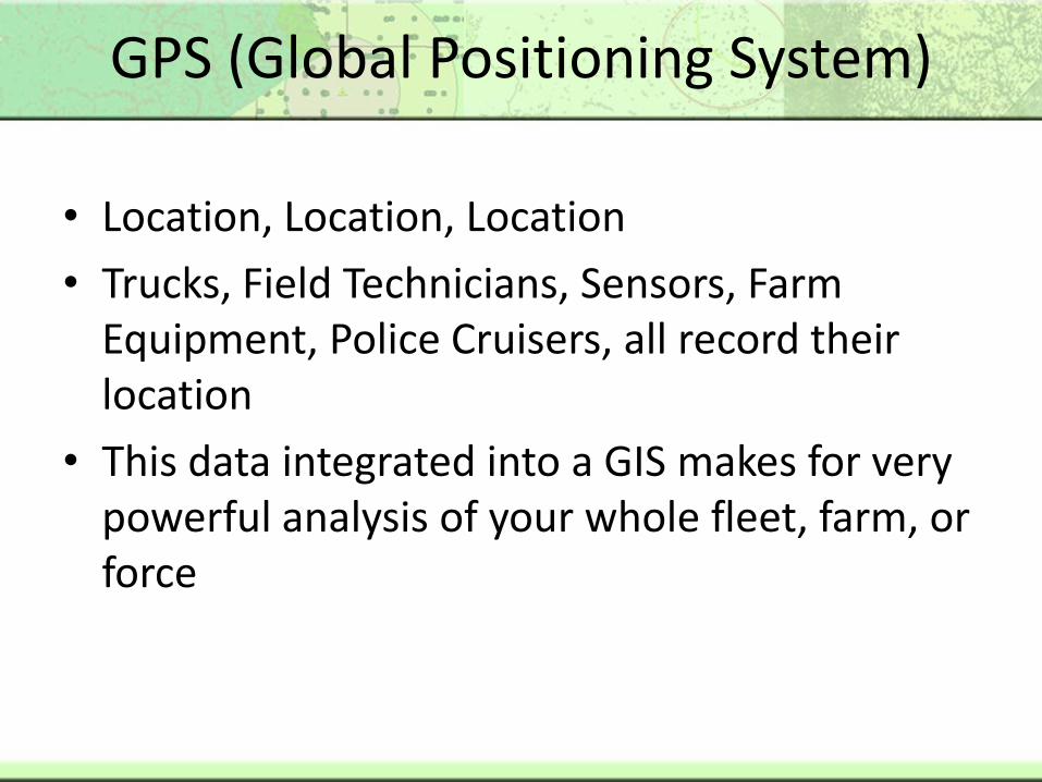
GPS (Global Positioning System)
• Location, Location, Location
• Trucks, Field Technicians, Sensors, Farm Equipment, Police Cruisers, all record their location
• This data integrated into a GIS makes for very powerful analysis of your whole fleet, farm, or force

Remote Sensing
• Remote Sensing provides data over wide areas without being at that location
• Fire Management, Forest Management, Agriculture studies, Weather Systems, Utility Networks
• Allows for wide area studies in a GIS

Surveying Technology
•Oldest of the Geospatial Technologies.
•Measure distances, directions, and angles between points and elevations of points, lines, and contours on, above, and below the earth’s surface.
•Highly precise and useful when millimeters count: legal battles, parcel boundaries, planning new construction or transportation networks
•Easily updated and managed in a GIS
•George Washington, Lewis and Clark were all Surveyors

Geospatial Technology is here…to stay!
The US Department of Labor researched the
emerging job markets in the United States
The top three are….
– Biotechnology
– Nanotechnology
– Geospatial Technology
• 35% Growth in Private Sector (US News & World Report)

Technology Growth in Career Clusters
11
16
33.2
20.919
11
16
0
5
10
15
20
25
30
35
Percentage Job Growth of Selected Sectors/Sub-Sectors 2008 - 2018
Source: National Employment Matrix from US Bureau of Labor and Statistics

Technology Growth in Career Clusters
0102030405060708090
100
Percentage Employment Growth of Selected Sectors/Sub-Sectors 2008 –2018 That Use Geospatial Technology
Source: National Employment Matrix from US Bureau of Labor and Statistics

Benefits of Teaching Geospatial Technology
• Teaching Job Skills that will be essential to a career cluster
• Cross Curricular: In addition to Career Cluster relevant “buttonology”, teaching geospatial sharpens:– Analytical Abilities
– Project Management
– Writing Skills
• Students learn skills that can lead to multiple career paths within and beyond their career cluster– Geospatial Skills will be relevant in all career clusters or geospatial
research

What if your student wants to work with geospatial technology research?
147
70 77
27.6
11.915.7
All Geospatial Jobs Surveyors, cartographers, and photogrammetrists
Surveying and mapping technicians
Geospatial Job Employment Outlook 2008 – 2018 (in Thousands of jobs)
2018 Levels
2008 Levels
Source: National Employment Matrix from US Bureau of Labor and Statistics

How do you get there?
• Build Your Program Around Certification!
• Available Geospatial Certifications are tied to the Geospatial Competency Training Model
• Certification provides means to show measured skills
• Geospatial Certifications are available that allow for continuing education from secondary education through professional development

Industry Backed Entry Level Certifications
SPACE Certification
• 180 Hours
• From Secondary
• Based on Examination
• GIS User Recognition
STARS Certification
• 360 Hours
• From Secondary
• Based on Examination/Capstone
• Geospatial Technician Recognition

SPACE Certifications for Career Clusters
Get Industry Backed Geospatial Certification with
recognition of a career cluster focus

SPACE & STARS Sponsors
• EIGS – Enterprise for Innovative Geospatial Solutions
• MsET - Mississippi Enterprise for Technology
• STARS GeoAP – Geospatial Apprenticeship Program Sponsored by Department of Labor
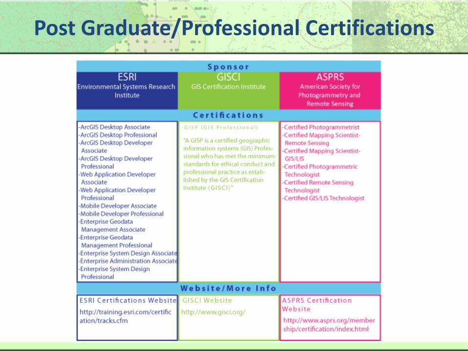
Post Graduate/Professional Certifications

Examples of Geospatial Technology Applied to Career Clusters
Agriculture, Food, & Natural Resources (7 Pathways)
– Food Products and Processing Systems
– Plant Systems
– Animal Systems
– Power, Structural, & Technical Systems
– Natural Resources Systems
– Environmental Systems
– Agribusiness Systems
– 8 Pathways including biotechnology

Food Products and Processing Systems
Mapping Poultry Processing Infrastructure
Source: Digital Quest

Plant SystemsManaging Chemical Application and limiting to necessary soil types
Source: Digital Quest

Animal SystemsCreating Virtual Fencing - Geospatially controlled using Directional Virtual Fencing (DVFTM)
Source: Digital Quest

Power, Structural, and Technical SystemsPrecision Farming – Evaluating AutoSteer technology impact on crop yield
Source: Digital Quest
Potential Yield Loss
Average Yield Average Yield Less Gaps
AverageYield
450400350300250200150100500
Bushels Per Acre
Bushels Per Field
AutoSteer
Traditional
The Price of Overlaps
CostPerAcre CostPerField
In D
olla
rs
1,200
1,000
800
600
400
200
0
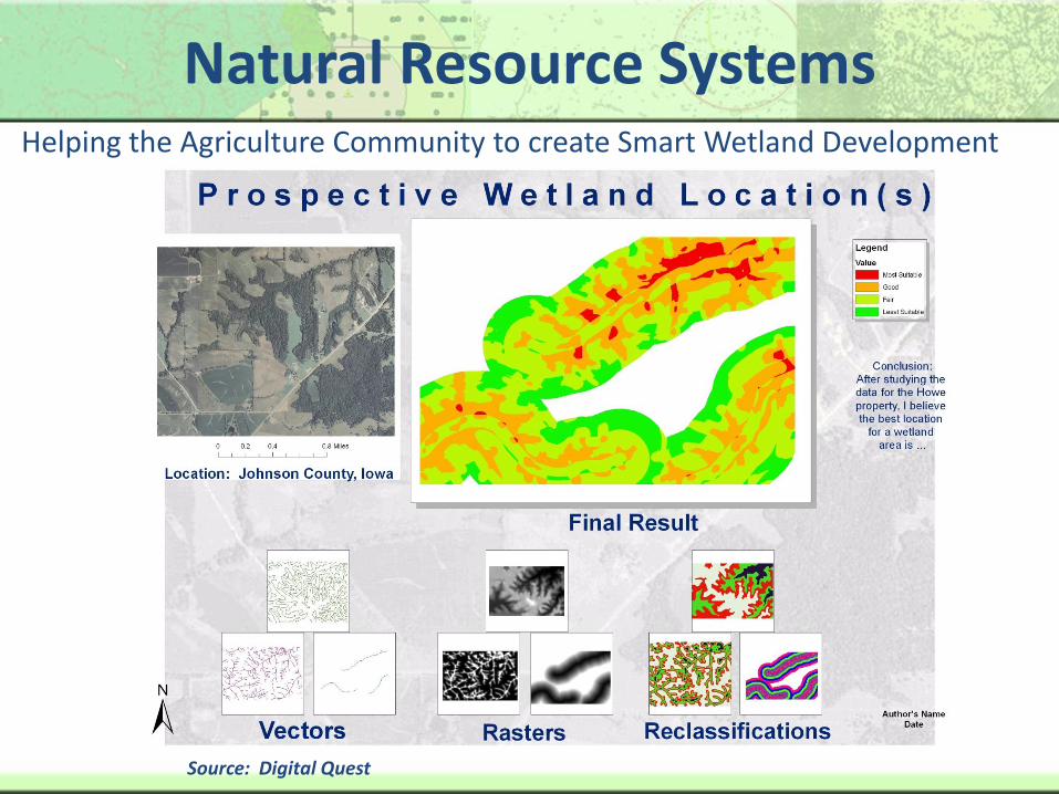
Natural Resource SystemsHelping the Agriculture Community to create Smart Wetland Development
Source: Digital Quest

Environmental Service Systems
Mitigating Nitrates in Beef Feedlot
Source: Digital Quest

Agribusiness Systems
Creating an Inventory of Agribusiness Locations
Source: Digital Quest

Plant Systems/BiotechnologyManaging genetic crops and measuring their yield
Source: Digital Quest

Overview of Application in Government and Public Administration
Homeland Security Applications
Source: Digital Quest

Overview of Application in MarketingEconomic Development/Gardening Applications
Source: Digital Quest

Overview of Application in Transportation, Distribution, & Logistics
Logistics/Routing Applications
Source: Digital Quest

Overview of Application in STEM
Environmental Science Applications
Source: Digital Quest

What are Students Doing After Certification?
• Gulfport High School - Gulfport, MS – Internships at NASA and MsET companies, looking at cross curricular research with social sciences department
• Michael Berry Career Center – Dearborn, MI – city internships for students and teacher mapping city sewer infrastructure
• Sandalwood High School – Jacksonville, FL– Local summer internships

What are Students Doing After Certification?
• Pearce High School - Richardson, TX – presenting to local council on water quality

What are Students Doing After Certification?
• Joppatowne High School – Joppatowne, MD – headline making program in Geospatial Technology and Homeland Security; top 2 places in state GIS competition
• York, PA – Student became certified in high school was accepted in the architectural program, New Jersey Institute of Technology. During his first semester, student’s advisor was so impressed with his technical knowledge of GIS and the ESRI ArcGIS software application, that he was asked to teach the fundamentals of ArcGIS to has classmates, and used this software in the freshman classes’ first group project. Student is also working as an intern for an architectural firm doing work for New York City’s Department of Planning.

How Do You Get Started?
• School/County Level
– Begin Exploring Curriculum Options that lead to certification
– See what state standards are available
• State Level
– Implement State Standards
– See if certifications are available for your state• Florida Sunshine Standards/FTE/CAPE

Wrap Up
Geospatial Technology is your world at work for you and your career clusters employers will be looking to
you to make it work for them!
Questions?
Thanks!