cape may to fenwick island - quick links · bookletchart cape may to fenwick island . noaa chart...
TRANSCRIPT

BookletChart™ Cape May to Fenwick Island NOAA Chart 12214
A reduced-scale NOAA nautical chart for small boaters When possible, use the full-size NOAA chart for navigation.

2
Published by the National Oceanic and Atmospheric Administration
National Ocean Service Office of Coast Survey
www.NauticalCharts.NOAA.gov 888-990-NOAA
What are Nautical Charts?
Nautical charts are a fundamental tool of marine navigation. They show water depths, obstructions, buoys, other aids to navigation, and much more. The information is shown in a way that promotes safe and efficient navigation. Chart carriage is mandatory on the commercial ships that carry America’s commerce. They are also used on every Navy and Coast Guard ship, fishing and passenger vessels, and are widely carried by recreational boaters.
What is a BookletChart?
This BookletChart is made to help recreational boaters locate themselves on the water. It has been reduced in scale for convenience, but otherwise contains all the information of the full-scale nautical chart. The bar scales have also been reduced, and are accurate when used to measure distances in this BookletChart. See the Note at the bottom of page 5 for the reduction in scale applied to this chart.
Whenever possible, use the official, full scale NOAA nautical chart for navigation. Nautical chart sales agents are listed on the Internet at http://www.NauticalCharts.NOAA.gov.
This BookletChart does NOT fulfill chart carriage requirements for regulated commercial vessels under Titles 33 and 44 of the Code of Federal Regulations.
Notice to Mariners Correction Status
This BookletChart has been updated for chart corrections published in the U.S. Coast Guard Local Notice to Mariners, the National Geospatial Intelligence Agency Weekly Notice to Mariners, and, where applicable, the Canadian Coast Guard Notice to Mariners. Additional chart corrections have been made by NOAA in advance of their publication in a Notice to Mariners. The last Notices to Mariners applied to this chart are listed in the Note at the bottom of page 7. Coast Pilot excerpts are not being corrected.
For latest Coast Pilot excerpt visit the Office of Coast Survey website at http://www.nauticalcharts.noaa.gov/nsd/searchbychart.php?chart=12214
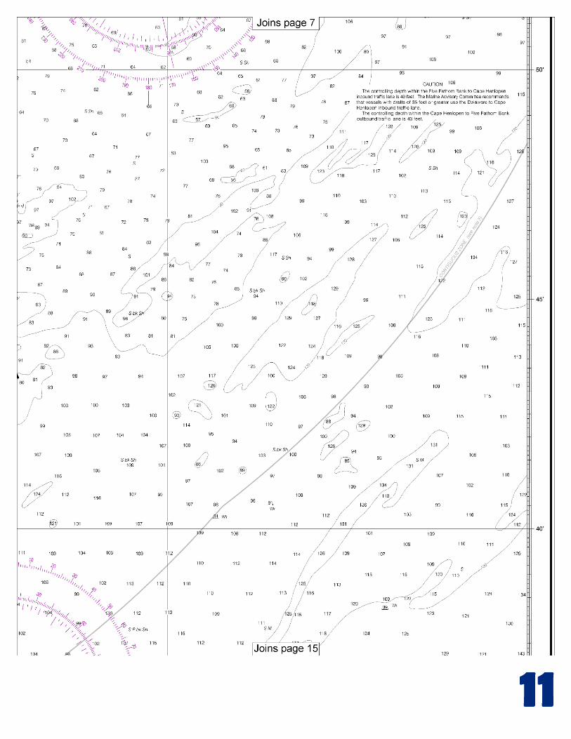
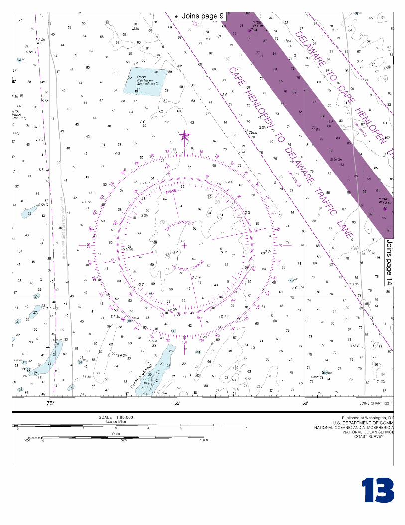
(Selected Excerpts from Coast Pilot) Delaware Bay and Delaware River form the boundary between the State of New Jersey on the east and the States of Delaware and Pennsylvania on the west. The bay is an expansion of the lower part of Delaware River; the arbitrary dividing line, 42 miles above the Delaware Capes, extends from Liston Point, Del., to Hope Creek, N.J. Deep-draft vessels use the Atlantic entrance, which is about 10 miles wide between Cape May on the northeast and Cape Henlopen
on the southwest. Vessels with drafts less than 33 feet can enter Delaware River from Chesapeake Bay through the Chesapeake and Delaware Canal 7.
Cape May is the extensive peninsula on the northeast side of the entrance to Delaware Bay. Cape May Light (38°55'59"N., 74°57'37"W.), 165 feet above the water, is shown from a white tower with a red cupola and two white dwellings nearby on Cape May Point. The shoals off Cape May are mixed clay and sand and have the consistency of hardpan; the ridges run in approximately the same directions as the currents. Cape May Channel, 1 mile southwest of the cape, is an unmarked passage between shoals, with depths from 2 to 4 feet on either side. The channel is seldom used, and then only by fishing vessels and pleasure craft; local knowledge is required for safe passage. The channels have strong currents, and many tide rips form near Prissy Wicks Shoal, which has depths as little as 2 feet about 2 miles south of Cape May Light. In Cape May Channel, the current velocity is 1.5 knots on the flood and 2.3 knots on the ebb. Vessel Draft Inbound.–1. Vessels less than 32’-06” FW may transit on any stage of the tide or current. 2. Vessels 32’-06” FW or greater up to 35’-00” FW in draft should arrive in Philadelphia harbor no later than 9 hours and 15 minutes, or earlier than 5 hours and 45 minutes from slack flood current at Cape Henlopen. 3. Vessels 35’-01”FW or greater up to 38’-06” FW in draft should arrive in Philadelphia harbor no later than 8 hours and 15 minutes, or earlier than 5 hours and 45 minutes from slack flood current at Cape Henlopen. 4. Vessels 32’-06” FW or greater up to 38’-06” FW in draft shall avoid meeting outbound shipping traffic above the Delair Railroad Bridge. North Atlantic Right Whales.–Endangered North Atlantic right whales may occur within 30 miles of the Delaware coast in the approaches to Delaware Bay and ports of Philadelphia (peak season: Nov. through Apr., although right whales have been sighted in the area year-round). (See North Atlantic Right Whales, indexed in chapter 3, for more information on right whales and recommended measures to avoid collisions.) All vessels 65 feet or greater in length overall (L.O.A.) and subject to the jurisdiction of the United States are restricted to speeds of 10 knots or less in a Seasonal Management Area existing around Delaware Bay between November 1 and April 30. The area is defined as waters within a 20-nm radius of 38°52’27.4”N., 75°01’32.1”W. (See 50 CFR 224.105 in chapter 2 for regulations, limitations, and exceptions.) Anchorages.–In 1993, the NOAA ship WHITING reported vessels waiting offshore before taking on pilots and proceeding into Delaware Bay often anchor in the area between the Eastern Directed Traffic Area and Southeastern Directed Traffic Area. The area has a mostly sand bottom and offers good holding ground in depths of 31 to over 100 feet. Deep-draft vessels sometimes anchor in various places along the dredged channel through the lower bay, but usually continue to more sheltered areas in the upper bay and river. General, explosives, quarantine, and naval anchorages are in Delaware Bay and Delaware River. (See 110.1 and 110.157, chapter 2, for limits and regulations.) Mariners are warned that submarine cables are in the north corner of the anchorage on the northeast side of New Castle Range. Furthermore, submerged pipelines are in the southwest part of the anchorage on the southeast side of Marcus Hook Range and in the middle of the anchorage southeast of Mifflin Range. In December 1983, shoaling to 34 feet was reported in the northeast corner of the anchorage off Mispillion River in about 39°01’12”N., 75°13’42”W. In bad weather, tows and small craft sometime anchor behind the breakwaters north and west of Cape Henlopen.
U.S. Coast Guard Rescue Coordination Center 24 hour Regional Contact for Emergencies
RCC Norfolk Commander 5th CG District (575) 398-6231 Norfolk, VA
G
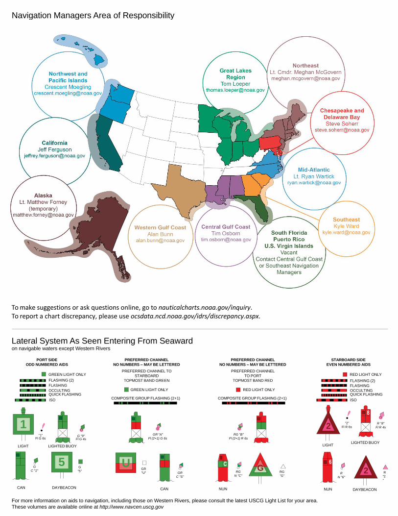
NOAA’s navigation managers serve as ambassadors to the maritime community. They help identify navigational challenges facing professional and recreational mariners, and provide NOAA resources and information for safe navigation. For additional information, please visit nauticalcharts.noaa.gov/service/navmanagers
To make suggestions or ask questions online, go to nauticalcharts.noaa.gov/inquiry. To report a chart discrepancy, please use ocsdata.ncd.noaa.gov/idrs/discrepancy.aspx.
Lateral System As Seen Entering From Seaward on navigable waters except Western Rivers
PORT SIDE
ODD NUMBERED AIDS
GREEN LIGHT ONLY
FLASHING (2)
PREFERRED CHANNEL
NO NUMBERS – MAY BE LETTERED
PREFERRED CHANNEL TO
STARBOARD
TOPMOST BAND GREEN
PREFERRED CHANNEL
NO NUMBERS – MAY BE LETTERED
PREFERRED CHANNEL
TO PORT
TOPMOST BAND RED
STARBOARD SIDE
EVEN NUMBERED AIDS
RED LIGHT ONLY
FLASHING (2)
FLASHING FLASHING
OCCULTING GREEN LIGHT ONLY RED LIGHT ONLY OCCULTING QUICK FLASHING QUICK FLASHING
ISO COMPOSITE GROUP FLASHING (2+1) COMPOSITE GROUP FLASHING (2+1) ISO
"1"
Fl G 6s
G "9"
Fl G 4s
GR "A"
Fl (2+1) G 6s
RG "B"
Fl (2+1) R 6s
"2"
Fl R 6s
8
R "8"
Fl R 4s
LIGHT
G
C "1"
LIGHTED BUOY
G
"5"
GR
"U"
GR
C "S"
RG
N "C"
RG
"G"
LIGHT
6
R
N "6"
LIGHTED BUOY
R
"2
"
CAN DAYBEACON
CAN NUN NUN
DAYBEACON
For more information on aids to navigation, including those on Western Rivers, please consult the latest USCG Light List for your area.
These volumes are available online at http://www.navcen.uscg.gov
Navigation Managers Area of Responsibility
Northeast
Lt. Meghan McGovern
Northwest and
Pacific Islands
Crescent Moegling
Great Lakes Region
Tom Loeper
Chesapeake and
Delaware Bay
Steve Soherr
California
Jeff Ferguson
[email protected] Mid-Atlantic
Lt. Ryan Wartick
Alaska
Lt. Timothy M. Smith
Western Gulf Coast
Alan Bunn
Central Gulf Coast
Tim Osborn
[email protected] South Florida
Puerto Rico
U.S. Virgin Islands
Michael Henderson
Southeast
Kyle Ward
2
2 C U 5
1


VHF Marine Radio channels for use on the waterways:Channel 6 – Inter-ship safety communications.Channel 9 – Communications between boats and ship-to-coast.Channel 13 – Navigation purposes at bridges, locks, and harbors.Channel 16 – Emergency, distress and safety calls to Coast Guard and others, and to initiate calls to other
vessels. Contact the other vessel, agree to another channel, and then switch.Channel 22A – Calls between the Coast Guard and the public. Severe weather warnings, hazards to navigation and safety warnings are broadcast here.Channels 68, 69, 71, 72 and 78A – Recreational boat channels.
Getting and Giving Help — Signal other boaters using visual distress signals (flares, orange flag, lights, arm signals); whistles; horns; and on your VHF radio. You are required by law to help boaters in trouble. Respond to distress signals, but do not endanger yourself.
EMERGENCY INFORMATION
Distress Call Procedures
• Make sure radio is on.• Select Channel 16.• Press/Hold the transmit button.• Clearly say: “MAYDAY, MAYDAY, MAYDAY.”• Also give: Vessel Name and/or Description;Position and/or Location; Nature of Emergency; Number of People on Board.• Release transmit button.• Wait for 10 seconds — If no responseRepeat MAYDAY call.
HAVE ALL PERSONS PUT ON LIFE JACKETS!
This Booklet chart has been designed for duplex printing (printed on front and back of one sheet). If a duplex option is not available on your printer, you may print each sheet and arrange them back-to-back to allow for the proper layout when viewing.
QR
Quick ReferencesNautical chart related products and information - http://www.nauticalcharts.noaa.gov
Interactive chart catalog - http://www.charts.noaa.gov/InteractiveCatalog/nrnc.shtmlReport a chart discrepancy - http://ocsdata.ncd.noaa.gov/idrs/discrepancy.aspx
Chart and chart related inquiries and comments - http://ocsdata.ncd.noaa.gov/idrs/inquiry.aspx?frompage=ContactUs
Chart updates (LNM and NM corrections) - http://www.nauticalcharts.noaa.gov/mcd/updates/LNM_NM.html
Coast Pilot online - http://www.nauticalcharts.noaa.gov/nsd/cpdownload.htm
Tides and Currents - http://tidesandcurrents.noaa.gov
Marine Forecasts - http://www.nws.noaa.gov/om/marine/home.htm
National Data Buoy Center - http://www.ndbc.noaa.gov/
NowCoast web portal for coastal conditions - http://www.nowcoast.noaa.gov/
National Weather Service - http://www.weather.gov/
National Hurrican Center - http://www.nhc.noaa.gov/
Pacific Tsunami Warning Center - http://ptwc.weather.gov/
Contact Us - http://www.nauticalcharts.noaa.gov/staff/contact.htm
NOAA’s Office of Coast Survey The Nation’s Chartmaker
For the latest news from Coast Survey, follow @NOAAcharts
NOAA Weather Radio All Hazards (NWR) is a nationwide network of radio stations broadcasting continuous weather information directly from the nearest National Weather Service office. NWR broadcasts official Weather Service warnings, watches, forecasts and other hazard information 24 hours a day, 7 days a week. http://www.nws.noaa.gov/nwr/