canterbury bankstown chapter 2 site considerations 2.1
TRANSCRIPT
_____________________________________________________________________________ Canterbury Bankstown DCP 2021–Chapter 2.1 Page | 1 DRAFT December 2020
Canterbury Bankstown Development Control Plan 2021 Chapter 2 Site Considerations 2.1 Site Analysis DRAFT December 2020

_____________________________________________________________________________ Canterbury Bankstown DCP 2021–Chapter 2.1 Page | 2 DRAFT December 2020
SECTION 1–SITE ANALYSIS PLANS Explanation Canterbury Bankstown Local Environmental Plan 2021 and Canterbury Bankstown Development Control Plan 2021 combine to regulate effective and orderly development, consistent with Connective City 2036. Canterbury Bankstown Local Environmental Plan 2021 is Council's principal planning document. It provides objectives, zones and development standards such as lot sizes, floor space ratios and building heights. Canterbury Bankstown Development Control Plan 2021 supports the LEP by requiring site analysis plans for certain development. Understanding the site is the first step in designing a development and is a mandatory part of the assessment process. The purpose of a site analysis is to identify how a development responds to the opportunities and constraints of a site and the surrounding streetscape. Objectives O1 To ensure site analysis plans identify the site features (opportunities and constraints). O2 To ensure site layouts:
(a) provide a pleasant, attractive, and resource–efficient living environment; (b) provide buildings, front fences, and landscaped areas that contribute positively to
the streetscape; (c) retain any item of identified conservation or heritage value; and (d) take into account site features such as topography, views, landmarks, trees,
vegetation, structures, drainage, services, access, orientation and microclimate. Development Controls 1.1 Development for the following purposes must submit a site analysis plan:
(a) attached dwellings; (b) boarding houses; (c) manor houses; (d) multi dwelling housing; (e) multi dwelling housing (terraces); (f) residential flat buildings; (g) serviced apartments; (h) shop top housing;

_____________________________________________________________________________ Canterbury Bankstown DCP 2021–Chapter 2.1 Page | 3 DRAFT December 2020
(i) housing estates; (j) mixed use development containing dwellings; (k) Torrens Title subdivision that proposes three or more lots.
1.2 The results of the site analysis must illustrate the following principles in the form of a
site analysis plan:
Principle 1: Context
Good design responds and contributes to its context. Responding to context involves identifying the desirable elements of a location’s current character or, in the case of precincts undergoing a transition, the desired future character as stated in planning and design policies. This will help a new building to contribute to the quality and identity of an area.
Principle 2: Scale
Good design provides an appropriate scale in terms of the bulk and height that suits the scale of the street and the surrounding buildings. Establishing an appropriate scale requires a considered response to the scale of existing development in the street. In precincts undergoing a transition, the proposed bulk and height needs to achieve the scale identified for the desired future character of the area.
Principle 3: Built form
Good design achieves an appropriate built form for a site and the building’s purpose in terms of building alignments, proportions, building type, and building elements. Appropriate built form defines the public domain, contributes to the character of streetscapes and parks, and provides internal amenity and outlook.
Principle 4: Density
Good design has a density appropriate for a site and its context in terms of floor space yields (or number of units). Appropriate densities are sustainable and consistent with the existing density in an area or, in precincts undergoing a transition, are consistent with the stated desired future density. In some cases, a sustainable density may mean a development will not achieve the maximum floor space ratio or density if it is to provide an environmental quality appropriate to the site.

_____________________________________________________________________________ Canterbury Bankstown DCP 2021–Chapter 2.1 Page | 4 DRAFT December 2020
Principle 5: Resource, energy, and water efficiency Good design makes efficient use of natural resources, energy, and water throughout its full life cycle. Sustainability is integral to the design process. Aspects include selection of appropriate and sustainable materials, layouts and built form, passive solar design principles, soil zones for vegetation, and reuse of water.
Principle 6: Landscape
Good design recognises the integration of landscape and buildings results in greater aesthetic quality and amenity for occupants and the adjoining public domain. Landscape design builds on the existing site’s natural and cultural features in responsible and creative ways. It enhances microclimate, tree canopy and habitat values, positive image to the streetscape and neighbourhood character, privacy, and respect for neighbours’ amenity.
Principle 7: Amenity
Good design provides amenity through the physical, spatial and environmental quality of a development. Optimising amenity requires appropriate room dimensions and shapes, access to sunlight, natural ventilation, visual and acoustic privacy, storage, indoor and outdoor space, efficient layouts and service areas, outlook, and ease of access for all age groups and degrees of mobility.
Principle 8: Safety and security
Good design optimises safety and security, both internal to the development and for the public domain. This is achieved by maximising overlooking of public and communal spaces while maintaining internal privacy, maximising activity on streets, providing clear access, providing quality public spaces that cater for desired recreational uses, providing lighting appropriate to the location, and clear definition between public and private spaces.
Principle 9: Social dimensions
Good design responds to the social context and needs of the local community in terms of lifestyles, affordability, and access to social facilities. New developments should optimise the provision of housing to suit the social mix and needs in the neighbourhood or, in the case of precincts undergoing transition, provide for the desired future community.

_____________________________________________________________________________ Canterbury Bankstown DCP 2021–Chapter 2.1 Page | 5 DRAFT December 2020
Principle 10: Aesthetics
Good design achieves a built form that has good proportions and a balanced composition of elements, reflecting the internal layout and structure. Good design uses a variety of materials, colours and textures. The visual appearance of well–designed development responds to the desirable elements of the existing streetscape or, in precincts undergoing transition, contribute to the desired character of the area.

_____________________________________________________________________________ Canterbury Bankstown DCP 2021–Chapter 2.2 Page | 1 DRAFT December 2020
Canterbury Bankstown Development Control Plan 2021 Chapter 2 Site Considerations 2.2 Flood Risk Management DRAFT December 2020

_____________________________________________________________________________ Canterbury Bankstown DCP 2021–Chapter 2.2 Page | 2 DRAFT December 2020
CONTENTS Section 1 Introduction………………………………………………………...……………………….. 3 Section 2 Criteria for Determining Applications…………………………………………..… 5 Section 3 Development Controls………………………………………………………..…………. 7 Section 4 Special Considerations…………………………………………………………..………. 10 Section 5 Fencing............................................................................................... 16 Section 6 Schedules………………….…………………………………………………………………... 17 Section 7 Explanatory Notes on Lodging Applications…………………………………… 70 Section 8 Definitions………………….…………………………………………………………………. 73
_____________________________________________________________________________ Canterbury Bankstown DCP 2021–Chapter 2.2 Page | 3 DRAFT December 2020
SECTION 1–INTRODUCTION Explanation Canterbury Bankstown Local Environmental Plan 2021 and Canterbury Bankstown Development Control Plan 2021 combine to regulate effective and orderly development, consistent with Connective City 2036. Canterbury Bankstown Local Environmental Plan 2021 is Council's principal planning document. It provides objectives, zones and development standards such as lot sizes, floor space ratios, building heights and flood planning. Canterbury Bankstown Development Control Plan 2021 supports the LEP by providing additional objectives and development controls to control the development of flood liable land in Canterbury Bankstown. Objectives O1 To reduce the risk to human life and damage to property caused by flooding through
controlling development on land affected by potential floods. O2 To control development and other activity within each of the individual floodplains in
Canterbury Bankstown having regard to the characteristics and level of information available for each of the floodplains.
O3 To assess applications for development on land that could be flood affected in
accordance with the principles included in the Floodplain Development Manual, issued by the NSW Government.
Land to which Chapter Applies Chapter 2.2 of this DCP applies to flood liable land in Canterbury Bankstown: (a) Catchments affected by floodplain risk management plans and flood studies
The floodplain risk management plans and flood studies adopted by Council identify flood liable land, and maps showing flood liable land will be held in the office of Council.
_____________________________________________________________________________ Canterbury Bankstown DCP 2021–Chapter 2.2 Page | 4 DRAFT December 2020
(b) Other flood liable land
Other flood liable land for catchments that are affected by riverine or stormwater flooding will be identified through an ongoing floodplain risk management process but may also be identified through a site specific flood study. The habitable floor levels of development are to be a minimum 500mm above the 100–year flood level.
Note: If a catchment is affected by riverine or stormwater flooding and Council is yet to adopt a draft floodplain risk management plan or flood study, all sites in that catchment must be regarded as being flood liable and are defined as a flood lot for the purposes of the State Environmental Planning Policy (Exempt and Complying Development Codes) 2008.

_____________________________________________________________________________ Canterbury Bankstown DCP 2021–Chapter 2.2 Page | 5 DRAFT December 2020
SECTION 2–CRITERIA FOR DETERMINING APPLICATIONS Explanation The criteria for determining applications for proposals potentially affected by flooding are structured in recognition that different controls are applicable to different land uses and levels of potential flood inundation and hazard. The procedure to determine what controls apply to proposed development involves:
• Schedule 2 identifies the land use category of the development.
• Determine which floodplain and which flood risk precinct the land is located within (refer to this section and relevant flood risk mapping).
• Apply the controls outlined in Section 3.
• Section 4 identifies special considerations which will apply only to some development in specific circumstances.
• Section 5 provides controls for fencing in the floodplain.
• Section 6 includes details of schedules identified in Section 3. Land Use Categories 2.1 Council has adopted eight major land use categories which are identified as:
• Critical uses and facilities
• Sensitive uses and facilities
• Subdivision
• Residential
• Commercial or industrial
• Tourist related development
• Recreation or non–urban uses
• Concessional development.
The specific uses, as defined by the applicable environmental planning instruments, which may be included in each category, are listed in Schedule 2.

_____________________________________________________________________________ Canterbury Bankstown DCP 2021–Chapter 2.2 Page | 6 DRAFT December 2020
Flood Risk Precincts 2.2 Based on the different levels of potential flood risk, each of the floodplains in
Canterbury Bankstown is divided into four categories of flood risk precinct. The relevant Flood Risk Precincts for each of the floodplains are outlined below.
(a) High flood risk precinct
High Flood Risk Precinct is the area of land below the 100–year flood that is either subject to a high hydraulic hazard or where there are significant evacuation difficulties. Most development should be restricted in this precinct as development in high flood risk precinct is associated with higher risk to life and evacuation difficulties during the event of flood. In this precinct, there would be a significant risk of flood damages without compliance with flood related building and planning controls.
(b) Medium flood risk precinct
Medium Flood Risk Precinct is land below the 100–year flood that is not subject to a high hydraulic hazard and where there are no significant evacuation difficulties. There would still be a significant risk of flood damage in this precinct. However, these damages can be minimised by the application of appropriate development controls.
(c) Overland flow risk precinct
Overland Flow Risk Precinct is areas of shallow overland flow, typically less than 0.25 metres in depth in a 100–year flood and distant from a recognised watercourse or major drainage system.
(d) Low flood risk precinct
Low Flood Risk Precinct is defined as all other land within the floodplain (within the extent of the probable maximum flood) but not identified within either the High Flood Risk or the Medium Flood Risk Precinct. The risk of damages due to flood event in low flood risk precinct is low for most of the land uses.

_____________________________________________________________________________ Canterbury Bankstown DCP 2021–Chapter 2.2 Page | 7 DRAFT December 2020
SECTION 3–DEVELOPMENT CONTROLS Explanation The development controls are graded relative to the severity and frequency of potential floods, having regard to categories determined by the relevant Floodplain Risk Management Study and Plan or, if no such study or plan exists, Council’s interim considerations. The development controls applicable to each floodplain are included within the planning matrices contained in the following schedules:
• Schedule 3–Georges River Floodplain generally but excluding sections of floodplain referred to separately.
• Schedules 4A, 4B and 4C–The Carinya Road area. The Carinya Road area has been excluded from the main schedule applying to the Georges River, as it has always been considered a special case, as indicated by the fact that this area has been subject to its own DCP (DCP 9D). As an outcome of the Georges River Floodplain Management Study, the controls for this area have been reviewed, although in general the controls that were first included in DCP 9D have largely been retained.
• Schedule 5–Catchments affected by Stormwater Flooding. This schedule defines development controls for flood liable land in catchments affected by stormwater flooding. Flood liable land is identified through:
• Council's ongoing flood study and flood risk management process.
• Site specific flood studies, in cases where a flood study or floodplain risk management plan has not been finalised and adopted by Council.
Where floodplain risk management plans and flood studies are adopted by Council, maps showing flood liable land will be held in the office of Council.
Note: If a catchment is affected by riverine or stormwater flooding and Council is yet to adopt a draft floodplain risk management plan or flood study:
• Flood liable land in these catchments will be identified through an ongoing floodplain risk management process but may also be identified through a site specific flood study. The habitable floor levels of development are to be a minimum 500mm above the 100–year flood level.
• All sites in that catchment must be regarded as being flood liable and are defined as a flood lot for the purposes of the State Environmental Planning Policy (Exempt and Complying Development Codes) 2008.

_____________________________________________________________________________ Canterbury Bankstown DCP 2021–Chapter 2.2 Page | 8 DRAFT December 2020
Objectives O1 To require development with high sensitivity to flood risk to be designed so that they
are subject to minimal risk. O2 To allow development with a lower sensitivity to the flood hazard to be located within
the floodplain, provided the risk of harm and damage to property is minimised. O3 To minimise the intensification of the High Flood Risk Precinct or floodway, and if
possible, allow for their conversion to natural waterway corridors. O4 To ensure design and siting controls required to address the flood hazard do not result
in unreasonable social, economic or environmental impacts upon the amenity or ecology of an area.
O5 To minimise the risk to life by ensuring the provision of reliable access from areas
affected by flooding. O6 To minimise the damage to property (including motor vehicles) arising from flooding. O7 To ensure the proposed development does not expose existing development to
increased risks associated with flooding. Development Controls Performance criteria 3.1 The proposed development should not result in any significant increase in risk to human
life, or in a significant increase in economic or social costs as a result of flooding. 3.2 The proposal should only be permitted where effective warning time and reliable access
is available to an area free of risk from flooding, consistent with any relevant Flood Plan or flood evacuation strategy.
3.3 Development should not significantly increase the potential for damage or risk other
properties either individually or in combination with the cumulative impact of development that is likely to occur in the same floodplain.
3.4 Motor vehicles are able to be relocated, undamaged, to an area with substantially less
risk from flooding, within effective warning time.

_____________________________________________________________________________ Canterbury Bankstown DCP 2021–Chapter 2.2 Page | 9 DRAFT December 2020
3.5 Procedures would be in place, if necessary, (such as warning systems, signage or
evacuation drills) so that people are aware of the need to evacuate and relocate motor vehicles during a flood and are capable of identifying the appropriate evacuation route.
3.6 To minimise the damage to property, including motor vehicles arising from flooding. 3.7 Development should not result in significant impacts upon the amenity of an area by
way of unacceptable overshadowing of adjoining properties, privacy impacts (e.g. by unsympathetic house–raising) or by being incompatible with the streetscape or character of the locality.
Prescriptive controls 3.8 Schedules 3 and 4 outline the controls relevant to each of the floodplains to which
Chapter 2.2 of this DCP applies.

_____________________________________________________________________________ Canterbury Bankstown DCP 2021–Chapter 2.2 Page | 10 DRAFT December 2020
SECTION 4–SPECIAL CONSIDERATIONS Explanation When assessing proposals for development or other activity within the area to which Chapter 2.2 of this DCP applies, Council will take into consideration the following specific matters: (a) Proposals for house raising must demonstrate that the raised structure will not be at
risk of failure from the forces of floodwaters and will not result in significant adverse impacts upon the amenity and character of an area.
(b) Notwithstanding any other provision where a site is identified within a Voluntary Acquisition Scheme area, Council will only consent to: (i) development for minor works such as small awnings over existing floor balconies
or in–ground swimming pools; and (ii) capital investment intended for the property is not greater than the minimum
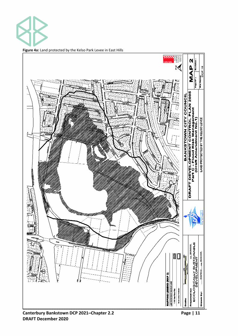
required to provide an acceptable proposal. Note: Council will not permit any type of development which would be inconsistent with the objective of not intensifying further development in areas of high risk and with Council's commitment to the Voluntary Acquisition Scheme. Development Controls Kelso Park, East Hills Levee Floodplain 4.1 This clause applies to land protected by the Kelso Park Levee, East Hills as shown in
Figure 4a.
The Kelso Park Levee was constructed for the purpose of protecting the properties behind the Levee from flooding from the Georges River. The levee provides protection for floods at least as high as the 100–year flood. However, some of the properties protected by the Levee may still be inundated by local stormwater flooding, though to a lesser degree. This would result from the escape of local stormwater being prevented by the Levee and the closure of floodgates in the Levee during flooding of the Georges River, or by levee failure and/ or overtopping in rare events.
Any approval for the erection or extension of a dwelling or other building on land to which this clause applies shall be accompanied by the following advice: “A Levee known as the Kelso Park Levee has been constructed for the purpose of protecting this property and a large number of other properties behind the Levee from flooding from the Georges River. The Levee could be overtopped in floods greater than the 100 year event”.
_____________________________________________________________________________ Canterbury Bankstown DCP 2021–Chapter 2.2 Page | 11 DRAFT December 2020
Figure 4a: Land protected by the Kelso Park Levee in East Hills
_____________________________________________________________________________ Canterbury Bankstown DCP 2021–Chapter 2.2 Page | 12 DRAFT December 2020
East Hills Floodplain 4.2 This clause applies to land at East Hills as shown in Figure 4b. All new dwellings, raised
dwellings, relocated dwelling houses, major additions and dual occupancies shall have direct fail–safe pedestrian access to land above the 100–year flood level.
4.3 Notwithstanding 4.2 above, the construction of an external staircase to the street
boundary will be accepted as satisfactory access for 528 to 558 Henry Lawson Drive for new dwellings, dual occupancies, raised dwellings, relocated dwelling houses and major additions provided the dwelling stands on the 5.5 metre building line. However, dual occupancies will only be permitted where the proposed flood mitigation works have been completed and after considering the effectiveness of proposed flood evacuation measures.

_____________________________________________________________________________ Canterbury Bankstown DCP 2021–Chapter 2.2 Page | 13 DRAFT December 2020
Figure 4b: East Hills Floodplain

_____________________________________________________________________________ Canterbury Bankstown DCP 2021–Chapter 2.2 Page | 14 DRAFT December 2020
Carinya Road, Picnic Point 4.4 This clause applies to land subject to the high and medium flood risk in the Carinya Road
area in Picnic Point as shown in Figure 4c.
(a) Subdivision and density controls (i) Proposed development must comply with the following residential density
controls: Area Maximum residential dwelling density
East of the boatshed 1 dwelling/ 650m2 of site area
West of the boatshed 1 dwelling/ 500m2 of site area
(ii) Other development controls for this area are included in Schedules 4B and
4C. The controls included in Schedule 4A also apply to this area, and to the land subject to a low flood risk as well.
(b) Scenic quality and amenity considerations
(i) The maximum height of buildings shall not exceed 9 metres to the topmost point of the structure from the existing ground level below.
(ii) The relevant flood risk management related development controls are provided in Schedule 4.
(iii) Where the proposed buildings are required to be elevated, the building needs to be designed to conform with the scale and character of existing development in the area.
(iv) The design of elevated walkways will need to address: privacy, overshadowing and impact on the scenic quality of the area. The length of the walkways should be minimised by locating dwellings as close as possible to Carinya Road.
(c) Prohibited land uses
(i) The following specific land uses normally permitted in the residential zone are prohibited within the Carinya Road area shown on Figure 4c: Child care centres, educational establishments, hospitals, residential flat buildings for aged persons not exceeding two storeys, places of assembly, places of public worship, dual occupancies, and seniors housing.

_____________________________________________________________________________ Canterbury Bankstown DCP 2021–Chapter 2.2 Page | 15 DRAFT December 2020
Figure 4c: Land subject to flood risk in the Carinya Road area in Picnic Point

_____________________________________________________________________________ Canterbury Bankstown DCP 2021–Chapter 2.2 Page | 16 DRAFT December 2020
SECTION 5–FENCING Objectives O1 To ensure that fencing does not result in the undesirable obstruction of the free flow of
floodwaters. O2 To ensure that fencing does not become unsafe during floods so as to threaten the
integrity of structures or the safety of people. Development Controls Performance criteria 5.1 Fencing is to be constructed in a manner which does not significantly increase flood
damage or risk on surrounding land. 5.2 Fencing shall be certified by a suitably qualified engineer, that the proposed fencing is
adequately constructed so as to withstand the forces of floodwaters, or collapse in a controlled manner to prevent the undesirable impediment of floodwaters.
Prescriptive controls 5.3 All fencing within a High flood risk precinct, and all fencing in other risk precinct that
obstructs flood flow will require a development application. 5.4 An applicant will need to demonstrate that the fence (new or replacement fence) would
create no impediment to the flow of floodwaters. Appropriate fences must satisfy the following: (a) an open collapsible hinged fence structure or pool type fence, or louver fencing; (b) other than a brick or other masonry type fence (which will generally not be
permitted); or (c) a fence type and siting criteria as prescribed by Council.

_____________________________________________________________________________ Canterbury Bankstown DCP 2021–Chapter 2.2 Page | 17 DRAFT December 2020
SECTION 6–SCHEDULES Schedule 1–Flood Compatible Materials
Building Component
Flood Compatible Material
Doors • solid panel with water proof adhesives
• flush door with marine ply filled with closed cell foam
• painted metal construction
• aluminium or galvanised steel frame
Floor Covering • clay tiles
• concrete, precast or in situ
• concrete tiles
• epoxy, formed–in–place
• mastic flooring, formed–in–place
• rubber sheets or tiles with chemical-set adhesives
• silicone floors formed–in–place
• vinyl sheets or tiles with chemical–set adhesive
• ceramic tiles, fixed with mortar or chemical–set adhesive
• asphalt tiles, fixed with water resistant adhesive
Flooring and Sub–floor Structure
• concrete slab–on–ground monolith construction
• suspension reinforced concrete slab
Insulation Windows
• foam (closed cell types)
• aluminium frame with stainless steel rollers or similar corrosion and water resistant material
Nails, Bolts, Hinges and Fittings
• brass, nylon or stainless steel
• removable pin hinges
• hot dipped galvanised steer wire nails or similar
Roofing Structure (for Situations Where the Relevant Flood Level is Above the Ceiling)
• reinforced concrete construction
• galvanised metal construction

_____________________________________________________________________________ Canterbury Bankstown DCP 2021–Chapter 2.2 Page | 18 DRAFT December 2020
Building Component
Flood Compatible Material
Wall Structure
• solid brickwork, blockwork, reinforced, concrete or mass concrete
Wall and Ceiling Linings
• fibro–cement board
• brick, face or glazed
• clay tile glazed in waterproof mortar
• concrete
• concrete block
• steel with waterproof applications
• stone, natural solid or veneer, waterproof grout
• glass blocks
• glass
• plastic sheeting or wall with waterproof adhesive

_____________________________________________________________________________ Canterbury Bankstown DCP 2021–Chapter 2.2 Page | 19 DRAFT December 2020
Building Component
Flood Compatible Material
Ducting All ductwork located below the relevant flood level should be provided with openings for drainage and cleaning. Self–draining may be achieved by constructing the ductwork on a suitable grade. Where ductwork must pass through a watertight wall or floor below the relevant flood level, the ductwork should be protected by a closure assembly operated from above relevant flood level.
Electrical and Mechanical Equipment
For dwellings constructed on land to which this Policy applies, the electrical and mechanical materials, equipment and installation should conform to the following requirements.
Equipment All equipment installed below or partially below the relevant flood level should be capable of disconnection by a single plug and socket assembly.
Fuel Heating systems using gas or oil as a fuel should have a manually operated valve located in the fuel supply line to enable fuel cut–off.
Heating and Air Conditioning Systems
Heating and air conditioning systems should, to the maximum extent possible, be installed in areas and spaces of the house above the relevant flood level. When this is not feasible every precaution should be taken to minimise the damage caused by submersion according to the following guidelines.
Installation The heating equipment and fuel storage tanks should be mounted on and securely anchored to a foundation pad of sufficient mass to overcome buoyancy and prevent movement that could damage the fuel supply line. All storage tanks should be vented to an elevation of 600 millimetres above the relevant flood level.
Main power supply
Subject to the approval of the relevant authority the incoming main commercial power service equipment, including all metering equipment, shall be located above the relevant flood level. Means shall be available to easily disconnect the dwelling from the main power supply.
Reconnection Should any electrical device and/ or part of the wiring be flooded it should be thoroughly cleaned or replaced and checked by an approved electrical contractor before reconnection.
Wiring All wiring, power outlets, switches and the like should, to the maximum extent possible, be located above the relevant flood level. All electrical wiring installed below the relevant flood level should be suitable for continuous submergence in water and should contain no fibrous components. Earth core linkage systems (or safety switches) are to be installed. Only submersible–type splices should be used below the relevant flood level. All conduits located below the relevant designated flood level should be so installed that they will be self–draining if subjected to flooding.

_____________________________________________________________________________ Canterbury Bankstown DCP 2021–Chapter 2.2 Page | 20 DRAFT December 2020
Schedule 2–Land Use Categories
Critical Uses and Facilities
Community facilities which may provide an important contribution to the notification or evacuation of the community during flood events; hospitals; nursing homes
Sensitive Uses and Facilities
Correctional centres; liquid fuel depots; offensive storage establishments; seniors housing; telecommunications facilities; waste disposal facilities; public utility undertakings (including generating works) which are essential to evacuation during periods of flood or if affected would unreasonably affect the ability of the community to return to normal activities after flood events
Subdivision Subdivision of land which involves the creation of new allotments, with potential for further development
Residential Attached dwellings; bed and breakfast establishments; boarding houses; camp sites or caravan parks (long–term sites(2) only); centre–based child care facilities; community facilities (other than sensitive uses and facilities); dual occupancies; dwellings; dwelling houses; educational establishments; family day care centres; health consulting rooms; home based child care; home businesses; home occupations; group homes; manor houses; multi dwelling housing; multi dwelling housing (terraces); residential flat buildings; secondary dwellings; semi–detached dwellings; serviced apartments; utility installations (other than critical utilities)
Commercial or Industrial
Amusement centres; business premises; car parks; depots; entertainment facilities; freight transport terminals; heliports; highway service centre; hotel or motel accommodation; industries; junkyards; light industries; material recycling yards; medical centres; neighbourhood shops; offensive industries; offensive storage establishments; office premises; passenger transport terminals; places of public worship; public administration buildings; pubs; recreation facilities (major); recreation facilities (indoor); registered clubs; research stations; restaurants; restricted premises; roadside stalls; service stations; sex services premises; shops; specialised retail premises; transport depots; vehicle body repair workshops; vehicle repair stations; vehicle sales or hire premises; veterinary hospitals; warehouse or distribution centres
Tourist Related Development
Camp sites or caravan parks (short–term sites(1) only)

_____________________________________________________________________________ Canterbury Bankstown DCP 2021–Chapter 2.2 Page | 21 DRAFT December 2020
Recreation or Non–Urban Uses
Agriculture; animal boarding or training establishments; boatsheds; dams; extractive industries; helipads; jetties; marinas; mines; recreation areas and minor ancillary structures (e.g. toilet blocks or kiosks/ cafes); recreation facilities (indoor and outdoor) other than those categorised under ‘commercial or industrial’; plant nurseries; sanctuaries; swimming pools; turf farming
Concessional Development
Residential development: (i) An addition or alteration to an existing dwelling of not more
than 50m2 to the habitable floor area which existed at the date of commencement of the former DCP on 5 March 2015;
(ii) The construction of an outbuilding with a maximum floor area of 30m2; or
(iii) Rebuilt dwellings which substantially reduce flood risk having regard to property damage and personal safety; or
(iv) A change of use which does not increase flood risk having regard to property damage and personal safety.
Other developments: (i) An addition to existing premises of not more than 10% of the
floor area which existed at the date of commencement of the former DCP on 5 March 2015;
(ii) Rebuilding of a development which substantially reduces the extent of flood effects to the existing development;
(iii) A change of use which does not increase flood risk having regard to property damage and personal safety; or
(iv) Subdivision which does not involve the creation of new allotments with potential for further development.
(1) As defined by the Local Government (Caravan Park and Camping Grounds) Transitional
Regulation 1993. (2) As defined by the Local Government (Caravan Park and Camping Grounds) Transitional
Regulation 1993.
_____________________________________________________________________________ Canterbury Bankstown DCP 2021–Chapter 2.2 Page | 22 DRAFT December 2020
SCHEDULE 3–GEORGES RIVER FLOODPLAIN
Planning Consideration
Flood Risk Precincts (FRPs)
Low Flood Risk Medium Flood Risk High Flood Risk C
riti
cal U
ses
& F
acil
itie
s
Sen
siti
ve
Use
s &
F
acil
itie
s
Su
bd
ivis
ion
Res
iden
tial
Co
mm
erci
al
& I
nd
ust
rial
To
uri
st
Rel
ated
D
evel
op
men
t R
ecre
atio
n &
N
on
-Urb
an
Co
nce
ssio
nal
D
evel
op
men
t
Cri
tica
l Use
s &
Fac
ilit
ies
Sen
siti
ve
Use
s &
F
acil
itie
s
Su
bd
ivis
ion
Res
iden
tial
Co
mm
erci
al
& I
nd
ust
rial
To
uri
st
Rel
ated
D
evel
op
men
t R
ecre
atio
n &
N
on
-Urb
an
Co
nce
ssio
nal
D
evel
op
men
t
Cri
tica
l Use
s &
Fac
ilit
ies
Sen
siti
ve
Use
s &
F
acil
itie
s S
ub
div
isio
n
Res
iden
tial
Co
mm
erci
al
& I
nd
ust
rial
To
uri
st
Rel
ated
D
evel
op
men
t
Rec
reat
ion
&
No
n-U
rban
Co
nce
ssio
nal
D
evel
op
men
t
Floor Level 3 2 2 2 1,6 4,7 2,6,7 5,6,7 2,6,7 1,6 4,7 1,6 4,7
Building Components 2 1 1 1 1 1 1 1
Structural Soundness 3 1 1 1 1 1 1 1
Flood Effects 2 3 3 3 3 3 3 1 2 2 2 2 2 1 1
Car Parking & Driveway Access 1,3,5,6,7 9 9 9 9 9 1,3,5,6,7 1,3,5,6,7 1,3,5,6,7 2,4,6,7 6,7,8 2,4,6,7 6,7,8
Evacuation 2,3,4 7 7 7 7 7 6 2,3 1,3 2,3 4,3 2,3 4,3 2,3
Management & Design 4,5 1 2,3,5 2,3,5 2,3,5 2,3,5 2,3,5 2,3,5
General Notes and Controls COLOUR LEGEND: Not Relevant Potentially Unsuitable Land Use
1 Freeboard equals an additional height of 500mm.
2 The relevant environmental planning instruments (generally the Local Environmental Plan) identify development permissible with consent in various zones in the LGA. Notwithstanding, constraints specific to individual sites may preclude Council granting consent for certain forms of development on all or part of a site. This matrix identifies where certain development types will be considered "potentially unsuitable" due to flood risks.
3 Council can consider a DA for a "potentially unsuitable use" that clearly complies with the objectives of this DCP and with the performance criteria. In this case, prescriptive controls will be applied on a DA specific.
3 Filling of the site, where acceptable to Council, may change the FRP considered to determine the controls applied in the circumstances of individual applications.
4 Refer to Section 5 of this DCP for planning considerations for proposals involving only the erection of a fence. Any fencing that forms part of a proposed development is subject to the relevant flood effects and structural soundness planning considerations of the applicable land use category.
5 Terms in italics are defined in the DCP and Schedule 2 specifies development types included in each land use category. These development types are generally as defined within Environmental Planning Instruments applying to the LGA.
6 From time to time, Council may adopt mapping showing the Boundary of Significant Flow and/or Flood Storage Areas for this floodplain. Refer to Council to find out if these areas have been defined and mapped for this floodplain.

_____________________________________________________________________________ Canterbury Bankstown DCP 2021–Chapter 2.2 Page | 23 DRAFT December 2020
Floor Level
1 All floor levels to be no lower than the 20-year flood unless justified by site-specific assessment.
2 Habitable floor levels to be no lower than the 100-year flood level plus freeboard.
3 Habitable floor levels to be no lower than the PMF level. Non-habitable floor levels to be no lower than the PMF level unless justified by a site-specific assessment.
4 Floor levels to be no lower than the design floor level. Where this is not practical due to compatibility with the height of adjacent buildings, or compatibility with the floor level of existing buildings, or the need for access for persons with disabilities, a lower floor level may be considered. In these circumstances, the floor level is to be a+B46s high as practical and when undertaking alterations and additions, no lower than the existing floor level.
5 The level of habitable floor areas to be equal to or greater than the 100-year flood level plus freeboard. If this level is impractical for a development in a Business zone, the floor level should be as high as possible.
6 Non-habitable floor levels to be no lower than the 20-year flood unless justified by site-specific assessment.
7 A restriction is to be placed on the title of the land, pursuant to S.88B of the Conveyancing Act, where the lowest habitable floor area is elevated more than 1.5m above finished ground level, confirming that the undercroft area is not to be enclosed. The use of roller shutters or similar measures (such as hit and miss brickwork) to enclose this area is however permissible.
Building Components & Method
1 All structures to have flood compatible building components below the 100-year flood level plus freeboard.
2 All structures to have flood compatible building components below the PMF level.
Structural Soundness
1 Engineer's report to certify that the structure can withstand the forces of floodwater, debris and buoyancy up to and including a 100-year flood plus freeboard.
2 Applicant to demonstrate that the structure can withstand the forces of floodwater, debris and buoyancy up to and including a 100-year flood plus freeboard. An engineer's report may be required.
3 Applicant to demonstrate that any structure can withstand the forces of floodwater, debris and buoyancy up to and including a PMF. An engineer’s report may be required.
Flood Effects
1 Engineer's report required to certify that the development will not increase flood effects elsewhere, having regard to: (i) loss of flood storage; (ii) changes in flood levels and velocities caused by alterations to the flood conveyance; and (iii) the cumulative impacts of multiple developments in the floodplain.
2 The flood impact of the development to be considered to ensure that the development will not increase flood effects elsewhere, having regard to: (i) loss of flood storage; (ii) changes in flood levels and velocities caused by alterations to the flood conveyance and (iii) the cumulative impacts of multiple potential developments in the floodplain. An engineer’s report may be required.
3 Flood impacts to be considered in the case of major development if Council advise that the development may generate flood impact, such as significant loss of storage or conveyance. Any assessment may also be asked to demonstrate that the proposed development is structurally sound.
Note: (1) If a Boundary of Significant Flow has been defined for this floodplain, any development inside this area will normally be unacceptable as it will reduce flood conveyance and increase flood effects elsewhere. (2) If a Flood Storage Area has been defined for this floodplain any filling of the floodplain inside this area (except where this occurs by compensatory evacuation), will normally be unacceptable as it will reduce the volume of flood storage available on the floodplain and increase flood effects elsewhere. (3) Even where a boundary of significant flow and or a storage area have been identified, developments outside these areas may still increase flood impacts elsewhere and therefore be unacceptable.
Car Parking and Driveway Access
1 The minimum surface level of open car parking spaces or carports shall be as high as practical, but no lower than the 20-year flood or the level of the crest of the road at the location where the site has access. In the case of garages, the minimum surface level shall be as high as practical, but no lower than the 20-year flood.
2 The minimum surface level of open car parking spaces, carports or garages, shall be as high as practical.
3 Garages capable of accommodating more than 3 motor vehicles on land zoned for urban purposes, or enclosed car parking, must be protected from inundation by floods up to the 100-year flood.
4 The driveway providing access between the road and parking space shall be as high as practical and generally rising in the egress direction.

_____________________________________________________________________________ Canterbury Bankstown DCP 2021–Chapter 2.2 Page | 24 DRAFT December 2020
5 The level of the driveway providing access between the road and parking space shall be no lower than 0.3m below the 100-year flood or such that the depth of inundation during a 100-year flood is not greater than either the depth at the road or the depth at the car parking space. A lesser standard may be accepted for single detached dwelling houses where it can be demonstrated that risk to human life would not be compromised.
6 Enclosed car parking and car parking areas accommodating more than 3 vehicles (other than on Rural zoned land), with a floor level below the 20-year flood or more than 0.8m below the 100-year flood level, shall have adequate warning systems, signage and exits.
7 Restraints or vehicle barriers to be provided to prevent floating vehicles leaving a site during a 100-year flood.
8 Driveway and parking space levels to be no lower than the design ground/floor levels. Where this is not practical, a lower level may be considered. In these circumstances, the level is to be as high as practical, and, when undertaking alterations or additions, no lower than the existing level.
9 Flood related parking and access requirements to be advised by Council if necessary. Contact Council for advice as early as possible.
Note: (1) A flood depth of 0.3m is sufficient to cause a typical vehicle to float. (2) Enclosed car parking is defined in the DCP and typically refers to carparks in basements.
Evacuation
1 Reliable access for pedestrians or vehicles required during a 100-year flood.
2 Adequate flood warning is available to allow safe and orderly evacuation without increased reliance upon the SES or other authorised emergency services personnel.
3 The development is to be consistent with any relevant flood evacuation strategy, Flood Plan adopted by Council or similar plan.
4 The evacuation requirements of the development are to be considered. A report from a suitably qualified and experienced person will be required if circumstances are possible where the evacuation of persons might not be achieved within the effective warning time.
5 Reliable access for pedestrians or vehicles required to a publicly accessible location above the PMF.
6 Applicant to demonstrate that evacuation in accordance with the requirements of this DCP is available for the potential development flowing from the subdivision proposal.
7 Evacuation requirements to be advised by Council if necessary. Contact Council for advice as early as possible.
Management and Design 1 Applicant to demonstrate that potential development as a consequence of a subdivision proposal can be undertaken in accordance with this DCP. 2 Site Emergency Response Flood Plan required where floor levels are below the design floor level, (except for single dwelling-houses). 3 Applicant to demonstrate that area is available to store goods above the 100-year flood level plus freeboard. 4 Applicant to demonstrate that area is available to store goods above the PMF level. 5 No storage of materials below the design floor level which may cause pollution or be potentially hazardous during any flood.

_____________________________________________________________________________ Canterbury Bankstown DCP 2021–Chapter 2.2 Page | 25 DRAFT December 2020
Sensitiv
e U
ses &
Facili
ties
Critical U
tilit
ies &
Uses
Subdiv
isio
n
Resid
ential (G
enera
l
inclu
din
g n
ew
& r
ebuilt
dw
elli
ngs)
Resid
ential (a
ltera
tions &
additio
ns o
ther
than
concessio
nal develo
pm
ent)
Resid
ential (h
ouse r
ais
ing)
Resid
ential (o
utb
uild
ings e
g.
Gara
ges,
carp
ort
s,
gard
en
sheds,
sw
imm
ing p
ools
)
Recre
ation &
Non-U
rban
Concessio
nal D
evelo
pm
ent
3 6 2,5 2 2,4 6 2,5 2 2 5 1 2 or 4
2 1 1 1 1 1 1 1 1 1
3 2 1 1 1 1#,2 2 1#,2
2 2 2,3 2 1 2,3 1,3 1,3 1,3 2 1,3
3,5 1,2 * 1,2,4 1,4 1,2 * 1,2,4 1#,4 1,4 3,4
4,5 1,7 1,7 2,3,5,6,7,8 2,5,6,7,8 2,5,6,8 5,6 2,3,5 3,5,8
Not Relevant Potentially Unsuitable Land Use
Freeboard equals an additional height of 500mm
*
Floor Level1
2
3
4
5
6
Flood
& High
All Floor Levels to be equal to or greater than the 20 year flood level plus freeboard unless justified by site specific assessment
Refer to 'Management & Design' planning
consideration for subdivision
Desirable but not mandatory. Will be considered
by Council on the merits of each application
Note: 1.Filling of the site, where acceptable to Council, may change the FRP considered to determine the
controls applied in the circumstances of individual applications.
2. Terms in italics are defined in the glossary of this plan and Schedule 2 specifies development types
included in each land use category. These development types are generally as defined within
Environmental Planning Instruments applying to the local go
3. Alterations & additions (except concessional development) are not permitted for existing dwellings which
have habitable floor areas below the 100 year flood level plus 0.5m freeboard .
Structural Soundness
#
Habitable floor levels to be equal to or greater than the 100 year flood level plus freeboard
All Floor Levels to be equal to or greater than the PMF flood level plus freeboard
Floor levels to be as close to the design floor level as practical & no lower than the existing floor level when undertaking alterations or additions
Restrictions to be placed on title advising of minimum floor levels required relative to flood level.
Evacuation
Medium
On allotments west of the boat shed with vehicle access to Carinya Road, which have new or additional dwellings constructed after the date of commencement of this Plan,
garages/carports/carspaces/driveways to have ground/floor levels equal to or greater t
Risk
Flood Risk Precincts (FRP's)
4. The relevant environmental planning instruments (generally the Local Environmental Plan) identify
development permissible with consent in various zones in the LGA. Notwithstanding, constraints specific to
individual sites may preclude Council granting
Planning and Development Controls
SCHEDULE 4A–CARINYA ROAD, PICNIC POINT FLOODPLAIN
Management & Design
Planning
Consideration
Low Flood Risk
Floor Level
Building Components
Flood Affectation
1
2
1
2
3
Flood Effects
1
2
3
1
2
3
4
Management and Design1
2
3
4
5
Engineers report required to certify that the development will not increase flood effects elsewhere, if proposed filling covers more than 200sq.m and extends more than 25m from the Carinya Road
frontage.
The impact of the development on flooding elsewhere to be considered
All structures to have flood compatible building components below or at the 100 year flood level plus freeboard
Reliable access for pedestrians and vehicles required during a PMF flood
1. Loss of storage area in the floodplain
Engineers report to certify that any structure can withstand the forces of floodwater, debris & buoyancy up to & including a 100 year flood plus freeboard
Structural Soundness
Note: When assessing flood effects the following must be considered:
Building Components & Method
All structures to have flood compatible building components below or at the PMF level plus freeboard
Applicant to demonstrate that any structure can withstand the forces of floodwater, debris & buoyancy up to & including a PMF flood plus freeboard
Applicant to demonstrate that any structure can withstand the forces of floodwater, debris & buoyancy up to & including a 100 year flood plus freeboard
No external storage of materials below the 100 year flood level plus freeboard, which may cause pollution or be potentially hazardous during a flood
Applicant to demonstrate that area is available to store goods above the PMF level plus freeboard
Reliable and failsafe access for vehicles (eg. garage, carport, driveway or carsoace) required at or above the 100 year flood level for allotments with frontage to Carinya Road and west of the boat
shed, which have new or additional dwellings constructed
2. Changes in flood levels & velocities caused by alteration of conveyance of flood waters
Limited filling will be considered for new dwellings in the area between new dwellings/garages and Carinya Road
Reliable and failsafe access for pedestrians required at or above the 100 year flood level, and not more than 0.5m below the highest floor level. This access is to be adjacent the side boundary.
Granting a R.O.W. to the adjoining owner is encouraged. In t
Evacuation
Applicant to demonstrate that area is available to store goods above the 100 year flood level plus freeboard
Site Emergency Response Flood plan required.
Applicant to demonstrate that potential development as a consequence of a subdivision proposal can be undertaken in accordance with this Plan
The development is to be consistent with any relevant flood evacuation strategy or similar plan

_____________________________________________________________________________ Canterbury Bankstown DCP 2021–Chapter 2.2 Page | 26 DRAFT December 2020
SCHEDULE 4B–CARINYA ROAD, PICNIC POINT FLOODPLAIN: Compilation of Development Controls for Residential Development
Type of Development Requirements
1. Additions to an existing dwelling whose floor level is already raised at least 0.5m above the 100 year flood level
• Habitable floor area extensions permitted at or above 100- year flood level plus 0.5m.
• Non-habitable floor area extensions permitted below 100- year flood level plus 0.5m.
• Outbuildings (garages, carports, sheds) permitted below the 100- year flood level, except for garages, driveways, carports, etc. on allotments west of the boat shed, with frontage to Carinya Road. Refer to Section below.
• Failsafe pedestrian access (walkways and stairs) encouraged but not mandatory.
• Failsafe vehicular access (driveways and car space) generally encouraged but not mandatory. However, new or improved garages, carports, driveways, car spaces, etc. on allotments west of the boat shed and with frontage to Carinya Road, must have ground/floor levels at or above the 100-year flood level.
• Construction methods for non-habitable areas used below the 100-year flood level plus 0.5m must preclude the area from being converted into a habitable room. Acceptable methods include single brick walls with roller shutter doors at opposite sides, lattice walling and the like. These construction methods will also assist in reducing damage during floods and will
_____________________________________________________________________________ Canterbury Bankstown DCP 2021–Chapter 2.2 Page | 27 DRAFT December 2020
Note: In the event of inconsistencies between Schedule 4A and Schedule 4B, Schedule 4A applies.
facilitate cleaning after a flood event.
• Construction materials used below the 100-year flood level plus 0.5m must comply with Schedule 3.
• Applications must include a certificate from a practising Structural Engineer verifying that the structure can withstand the force of flood waters (from debris and buoyancy) from a flood up to 1m above the 100-year level.
• Planning certificates to notify affectation by the 100-year flood.
• No external storage of materials (which may be hazardous during floods) below the 100- year flood level plus 0.5m.
• Allotment stormwater drainage to be designed to avoid adverse impact on adjoining properties.

_____________________________________________________________________________ Canterbury Bankstown DCP 2021–Chapter 2.2 Page | 28 DRAFT December 2020
SCHEDULE 4B–CARINYA ROAD, PICNIC POINT FLOODPLAIN: Compilation of Development Controls for Residential Development
Type of Development Requirements
2. Additions to an existing dwelling NOT already raised at least 0.5m above the 100-year flood level, including house raising
ADDITIONS ARE NOT PERMITTED, EXCEPT FOR MINOR ADDITIONS AND HOUSE RAISING
• Desirably, habitable floor levels to be equal to or above the 100 year flood level plus 0.5m. The floor level of minor additions are permitted below this level (but not below the existing floor level).
• Non-habitable floor area extensions are permitted below the 100-year flood level plus 0.5m.
• Outbuildings (garages, carports, sheds) permitted below the 100-year flood level, except for garages, driveways, carports, etc. on allotments west of the boat shed, with frontage to Carinya Road. Refer Section below.
• Failsafe pedestrian access (walkways and stairs) is required for house raising. For minor additions, such access is encouraged but is not mandatory.
• Failsafe vehicular access (driveways and car space) generally encouraged but not mandatory.
• Construction methods for non-habitable areas used below the 100-year flood level plus 0.5m must preclude the area from being converted into a habitable room. Acceptable methods include single brick walls with roller shutter doors at opposite sides, lattice walling and the like. These construction methods will also assist in reducing damage during floods and will facilitate cleaning after a flood event.
• Construction materials used below the 100-year flood level must comply with Schedule 3.

_____________________________________________________________________________ Canterbury Bankstown DCP 2021–Chapter 2.2 Page | 29 DRAFT December 2020
SCHEDULE 4B–CARINYA ROAD, PICNIC POINT FLOODPLAIN: Compilation of Development Controls for Residential Development
Type of Development Requirements
• Applications must include a certificate from a practising Structural Engineer verifying that the structure can withstand the force of flood waters (from debris and buoyancy) from a flood up to 1m above the 100-year level.
• Planning certificates to notify affectation by 100-year flood.
• No external storage of materials (which may be hazardous during floods) below 100 year flood level plus 0.5m.
• Allotment stormwater drainage to be designed to avoid adverse impact on adjoining properties.
Note: In the event of inconsistencies between Schedule 4A above and Schedule 4B, Schedule 4A applies.

_____________________________________________________________________________ Canterbury Bankstown DCP 2021–Chapter 2.2 Page | 30 DRAFT December 2020
SCHEDULE 4B–CARINYA ROAD, PICNIC POINT FLOODPLAIN: Compilation of Development Controls for Residential Development
Type of Development Requirements
3. Rebuilt dwellings
• Habitable floor levels to be equal to or above the 100 year flood level plus 0.5m.
• Non-habitable floor area extensions are permitted below the 100-year flood level plus 0.5m.
• Outbuildings (garages, carports, sheds) permitted below the 100-year flood level, except for garages, driveways, carports, etc on allotments west of the boat shed, with frontage to Carinya Road. Refer to section below.
• Failsafe pedestrian access (walkways and stairs) is required.
• Failsafe vehicular access (garages, carports, driveways, car spaces, etc) is required for allotments west of the boat shed and with frontage to Carinya Road, and must have ground/floor levels at or above the 100-year flood level. On other allotments, such access is encouraged but is not mandatory.
• Construction methods for non-habitable areas used below the 100-year flood level plus 0.5m must preclude the area from being converted into a habitable room. Acceptable methods include single brick walls with roller shutter doors at opposite sides, lattice walling and the like. These construction methods will also assist in reducing damage during floods and will facilitate cleaning after a flood event.
• Construction materials used below the 100-year flood level plus 0.5m must comply with Schedule 3.
• Applications must include a certificate from a practising Structural Engineer verifying that the structure can withstand the force of
_____________________________________________________________________________ Canterbury Bankstown DCP 2021–Chapter 2.2 Page | 31 DRAFT December 2020
SCHEDULE 4B–CARINYA ROAD, PICNIC POINT FLOODPLAIN: Compilation of Development Controls for Residential Development
Type of Development Requirements
flood waters (from debris and buoyancy) from a flood up to 1m above the 100-year level.
• Planning certificates to notify affectation by 100-year flood.
• No external storage of materials (which may be hazardous during floods) below 100-year flood level plus 0.5m.
• Allotment stormwater drainage to be designed to avoid adverse impact on adjoining properties.
• Consideration should be given to locating new dwellings close to Carinya Road to minimise the impact of walkways and filling.
Note: In the event of inconsistencies between Schedule 4A and Schedule 4B, Schedule 4A applies.

_____________________________________________________________________________ Canterbury Bankstown DCP 2021–Chapter 2.2 Page | 32 DRAFT December 2020
SCHEDULE 4B–CARINYA ROAD, PICNIC POINT FLOODPLAIN: Compilation of Development Controls for Residential Development
Type of Development Requirements
4. Additional dwellings
• Habitable floor levels to be equal or above the 100-year flood level plus 0.5m.
• Non-habitable floor areas are permitted below the 100-year flood level plus 0.5m.
• Outbuildings (garages, carports, sheds) permitted below the 100-year flood level, except for garages, driveways, carports, etc on allotments west of the boat shed, with frontage to Carinya Road. See Section below.
• Failsafe pedestrian access (walkways and stairs) is required.
• Failsafe vehicular access (garages, carports, driveways, car spaces, etc) is required for allotments west of the boat shed and with frontage to Carinya Road, and must have ground/floor levels at or above the 100-year flood level. On other allotments, such access is encouraged but is not mandatory.
• Construction methods for non-habitable areas used below the 100-year flood level plus 0.5m must preclude the area from being converted into a habitable room. Acceptable methods include single brick walls with roller shutter doors at opposite sides, lattice walling and the like. These

_____________________________________________________________________________ Canterbury Bankstown DCP 2021–Chapter 2.2 Page | 33 DRAFT December 2020
SCHEDULE 4B–CARINYA ROAD, PICNIC POINT FLOODPLAIN: Compilation of Development Controls for Residential Development
Type of Development Requirements
construction methods will also assist in reducing damage during floods and will facilitate cleaning after a flood event.
• Construction materials used below the 100-year flood level plus 0.5m must comply with Schedule 3.
• Applications must include a
certificate from a practising Structural Engineer verifying that the structure can withstand the force of flood waters (from debris and buoyancy) from a flood up to 1m above the 100-year level.
• Planning certificates to notify
affectation by 100-year flood. • No external storage of
materials (which may be hazardous during floods) below 100-year flood level plus 0.5m.

_____________________________________________________________________________ Canterbury Bankstown DCP 2021–Chapter 2.2 Page | 34 DRAFT December 2020
SCHEDULE 4B–CARINYA ROAD, PICNIC POINT FLOODPLAIN: Compilation of Development Controls for Residential Development
Type of Development Requirements
4. Additional dwellings (cont.) • Allotment stormwater drainage to be designed to avoid adverse impact on adjoining properties.
• Limited filling will be
considered in the area between new dwellings/garages and Carinya Road subject to – • It providing failsafe
pedestrian and/or vehicular access.
• A maximum filled area of 200m2.
• Filling not to extend more than 25m from the Carinya Road frontage.
• Any additional filling will only be considered if a flood effects statement is submitted demonstrating minimal impact.
• Provide a site flood plan. • Provide an area 0.5m above
100-year flood level for storage of goods.
• Proposals should involve
minimal impact on streetscape and adjoining properties. Plans and elevations showing visual impact on the streetscape and the impact on the amenity of adjoining properties will be required.
• Consideration should be given
to locating new dwellings close to Carinya Road to minimise the impact of walkways and filling.

_____________________________________________________________________________ Canterbury Bankstown DCP 2021–Chapter 2.2 Page | 35 DRAFT December 2020
SCHEDULE 4C–CONTROLS FOR SUBDIVISION IN CARINYA ROAD This Schedule specifies the development controls with which applications for subdivision must comply. The primary control for subdivision is the site area requirement, included in clause 4.4. This Schedule includes additional controls for subdivision, which apply to the properties that are known to comply with the site area requirements. Applications for subdivisions made in relation to the property referred to in Column 1 shall only be approved if it complies with the development control specified in Column 2. An application to subdivide a particular allotment will need to satisfy the requirements for both allotments that will be created from the subdivision. Requirements are outlined separately in the following table for top allotment closest to Carinya Road and the lower allotment away from Carinya Road. It should be noted that other controls may also be relevant to the consideration of an application for subdivision.
Property Address
Development Controls for Subdivision in Carinya Road
(1) 3 Carinya Road (a) Top Allotment
(i) Minimum site area is 650 square metres. (ii) Access shall be directly off Carinya Road.
(iii) There should be a minimum 5.5 metre setback from the
front boundary and a minimum of 900mm from each side boundary.
(iv) A minimum building envelope of 15 metres by 10
metres should be identified on the site. Any future building must be located within this area. This building envelope must not include the setbacks specified in (iii) above.
(v) Any new dwelling built on this lot must be located
above the 100-year flood line. However, a dwelling can partially locate below this level to satisfy the building envelope requirement. In this situation the usual floor level requirement (100 year flood plus half a metre) will still apply;

_____________________________________________________________________________ Canterbury Bankstown DCP 2021–Chapter 2.2 Page | 36 DRAFT December 2020
(vi) Any new garage and /or parking area must be located above the 100 year flood level;
(vii) An area shall be identified on the site to accommodate
a permanent flood free access way from the lower allotment created by this subdivision extending from the lower boundary of the lot to above the 100 year flood line and thence to Carinya Rd. The construction of the accessway can be deferred until such time as a dwelling is constructed, but its location should be identified at subdivision stage and included in a sec 88B Notation on the Certificate of Title. Its location shall be considered in relation to it being used by future occupants of the lower allotment that would be created by this subdivision, and the present occupants of Nos 3A and the adjoining lots at No 5 Carinya Rd.
(viii) The accessway referred to above must be constructed
when a dwelling is built. It shall be designed to minimize loss of visual amenity, including by way of the following:
• Keeping the accessway as short as possible;
• Appropriate design to minimize visual impact;
• Integrating with the design of the dwelling; (ix) The accessway shall also be built to:
• Withstand forces of floodwater. A report from a qualified structural/hydraulic engineer is required to substantiate this.
• Built to appropriate safety standards to ensure that no one can fall off it;
• Not facilitate unauthorized access to the dwellings.
(x) Easements shall be created over the property in favour
of the 2 allotments below (being Nos 3 and 3A Carinya Rd) providing for permanent flood free access for pedestrians from these properties over this property to Carinya Rd. A driveway will satisfy this access requirement above the 100-year flood level.
(xi) This easement should if possible be located on the
western side of the property to facilitate sharing of the access way with residences at No 5, 5A and 5B Carinya

_____________________________________________________________________________ Canterbury Bankstown DCP 2021–Chapter 2.2 Page | 37 DRAFT December 2020
Rd. The easement should be registered and included as a sec 88b Notation on the Certificate of Title.
(xii) Limited filling will be considered in the area between
any new dwelling and/or garage and Carinya Rd subject to:
• It providing failsafe pedestrian or vehicular access;
• Filling not to extend more than 25 metres from the Carinya Rd frontage;
• There is a maximum filled area of 200 sq metres; Larger volumes may be considered if compensatory fill removal occurs elsewhere on the site; and
• A report is submitted from a suitably qualified and experienced person demonstrating minimal flood impact.
(b) Lower Allotment
(i) Minimum site area is 650 square metres.
(ii) Vehicle access shall be from Reserve Rd. An access handle of 3.5 metres width must also be provided from Reserve Rd. (See note 1 at end of this Schedule)
(iii) There should be a minimum setback from the side
boundaries of 900mm.
(iv) A minimum building envelope of 15 metres by 10 metres should be identified on the site. Any future building must be located within this area. This building envelope must not include the setbacks specified in (iii) above.
(v) Where the above requirement permits, and where
feasible due to other site constraints, any new dwelling on this allotment shall be built a maximum of 10 metres from the northern boundary of this allotment.
(vi) Future development of this lot must provide for
permanent failsafe flood free pedestrian access from the dwelling. It should start from the floor level of the dwelling, and extend over the allotment and link with the easement and/or accessway created over the top allotment. It should also be constructed to enable its use by the current occupants of Nos 3A and 5, 5B and 5A Carinya Rd. Construction can be deferred until

_____________________________________________________________________________ Canterbury Bankstown DCP 2021–Chapter 2.2 Page | 38 DRAFT December 2020
dwelling construction, but its location must be identified and specified on a sec 88B Restriction as to user Notation on the Certificate of Title.
(vii) Easements shall be created over the property in favour
of the allotment below (being No 3A Carinya Rd) as well as the property at 5, 5A and 5B Carinya Rd that provides for permanent flood free access for pedestrians over this property to the adjoining allotment to the north and thence to Carinya Rd. The easement should be registered and included as a sec 88b Notation on the Certificate of Title.
(viii) The flood free access referred to above must be
constructed when a dwelling is built. It must be designed to minimize loss of visual amenity, including by way of the following:
• Keeping the accessway as short as possible, by building the dwelling close to the northern allotment boundary;
• Appropriate design to minimize visual impact;
• Integrating with the design of the dwelling; (ix) The accessway shall also be built to:
• Withstand forces of floodwater. A report from a qualified structural/hydraulic engineer is required to substantiate this.
• Be safe and ensure that no one can fall off it;
• Not facilitate unauthorized access to the dwellings.
(x) Limited filling will be considered in this allotment
subject to:
• It being used to help provide failsafe pedestrian access;
• There is a maximum filled area of 200 sq metres; Larger volumes may be considered if compensatory fill removal occurs elsewhere on the site; and
• A report is submitted from a suitably qualified and experienced person demonstrating minimal flood impact.
_____________________________________________________________________________ Canterbury Bankstown DCP 2021–Chapter 2.2 Page | 39 DRAFT December 2020
(2) 13a Carinya Road (a) Top Allotment
(i) Minimum site area is 650 square metres.
(ii) Vehicle access shall be from Carinya Rd.
(iii) There should be a minimum 5.5 metre setback from the front boundary and a minimum of 900mm from each side boundary.
(iv) A minimum building envelope of 15 metres by 10 metres should be identified on the site. Any future building must be located within this area. This building envelope must not include the setbacks specified in (iii) above.
(v) Where permitted by the above requirement, any new
dwelling built on this lot must be located above the 100-year flood line unless this is not possible due to the topography or other site constraints (such as bushfire issues or vegetation clearing. However, a dwelling can partially locate below this level if necessary to satisfy the building envelope requirement. In this situation the usual floor level requirement (100 year flood plus half a metre) will still apply.
(vi) Any new garage and /or parking area must be located
above the 100-year flood level.
(vii) An area shall be identified on the site to accommodate a permanent flood free access way from the southern allotment boundary extending to above the 100-year flood line and thence to Carinya Rd. The construction of the accessway can be deferred until such time as a dwelling is constructed, but its location should be identified at subdivision stage and included in a sec 88B Notation on the Certificate of Title. Its location shall be considered in relation to it being used by future occupants of the lower allotment that would be created by this subdivision, and the present occupants of Nos 13 and 15 Carinya Rd.
(viii) The accessway referred to above must be constructed
when a dwelling is built.
(ix) Easements shall be created over the property in favour of the 2 allotments below (being No 13A Carinya Rd as well as the allotment created by this subdivision) that provides for permanent flood free access for

_____________________________________________________________________________ Canterbury Bankstown DCP 2021–Chapter 2.2 Page | 40 DRAFT December 2020
pedestrians over this property to Carinya Rd. A driveway will satisfy this access requirement above the 100-year flood level. This easement should if possible be located on the western side of the property to facilitate sharing of the flood free access way access with residence at 15 Carinya Rd. The easement should be registered and included as a sec 88b Notation on the Certificate of Title.
(x) Any flood free access shall be designed to minimize loss
of visual amenity, including by way of the following:
• Keeping the accessway as short as possible;
• Appropriate design to minimize visual impact;
• Integrating with the design of the dwelling; (xi) The walkway shall also be built to:
• Withstand forces of floodwater. A report from a qualified structural/hydraulic engineer is required to substantiate this.
• Built to appropriate safety standards to ensure that no one can fall off it;
• Not facilitate unauthorized access to the dwellings.
(xii) Limited filling will be considered in the area between
any new dwelling and/or garage and Carinya Rd subject to:
• It providing failsafe pedestrian or vehicular access;
• Filling not to extend more than 25 metres from the Carinya Rd frontage;
• There is a maximum filled area of 200 sq metres; Larger volumes may be considered if compensatory fill removal occurs elsewhere on the site; and
• A report is submitted from a suitably qualified and experienced person demonstrating minimal flood impact.
_____________________________________________________________________________ Canterbury Bankstown DCP 2021–Chapter 2.2 Page | 41 DRAFT December 2020
(b) Lower Allotment
(i) Minimum site area is 650 square metres. (ii) Vehicle access shall be from Reserve Rd. An access handle
of 3.5 metres width must also be provided from Reserve. (See note 1 at end of this Schedule)
(iii) There should be a minimum 5.5 metre setback from the
front boundary and a minimum of 900mm from each side boundary.
(iv) A minimum building envelope of 15 metres by 10 metres
should be identified on the site. Any future building must be located within this area. This building envelope must not include the setbacks specified in (iii) above.
(v) Where the above requirement permits, and where feasible due to other site constraints, any new dwelling on this allotment shall be built a maximum of 10 metres from the northern boundary of this allotment.
(vi) Future development of this lot must provide for permanent
failsafe flood free pedestrian access from the dwelling. It should start from the floor level of the dwelling, and extend over the allotment and link with the easement and/or accessway created over the top allotment. It should also be constructed to enable its use by the current occupants of Nos 13A and 15 Carinya Rd. Construction can be deferred until dwelling construction, but its location must be identified and specified on a sec 88B Restriction as to user Notation on the Certificate of Title.
(vii) Easements shall be created over the property in favour of
the allotment below (being No 13A Carinya Rd) as well as the property at 15 Carinya Rd that provides for permanent flood free access for pedestrians over this property to Carinya Rd. The easement should be registered and included as a sec 88b Notation on the Certificate of Title.
(viii) The flood free access referred to above must be constructed
when a dwelling is built. It must be designed to minimize loss of visual amenity, including by way of the following:

_____________________________________________________________________________ Canterbury Bankstown DCP 2021–Chapter 2.2 Page | 42 DRAFT December 2020
• Keeping the accessway as short as possible, by building the dwelling close to the northern allotment boundary;
• Appropriate design to minimize visual impact;
• Integrating with the design of the dwelling; (ix) The accessway shall also be built to:
• Withstand forces of floodwater. A report from a qualified structural/hydraulic engineer is required to substantiate this.
• Be safe and ensure that no one can fall off it;
• Not facilitate unauthorized access to the dwellings (x) Limited filling will be considered in this allotment
subject to:
• It being used to help provide failsafe pedestrian access;
• There is a maximum filled area of 200 sq metres; Larger volumes may be considered if compensatory fill removal occurs elsewhere on the site; and
• A report is submitted from a suitably qualified and experienced person demonstrating minimal flood impact.
(3) 23 Carinya Road (a) Top Allotment
(i) Minimum site area is 650 square metres. (ii) Access shall be directly off Carinya Rd. (iii) There should be a minimum 5.5 metre setback from the
front boundary and a minimum of 900mm from each side boundary.
(iv) A minimum building envelope of 15 metres by 10
metres should be identified on the site. Any future building must be located within this area. This building envelope must not include the setbacks specified in (iii) above.
(v) Where the above requirement permits, any new
dwelling must be located above the 100 year flood line where this is possible having regard to other site constraints. However, a dwelling can partially locate below this level if necessary to satisfy the building envelope requirement. In this situation the usual floor

_____________________________________________________________________________ Canterbury Bankstown DCP 2021–Chapter 2.2 Page | 43 DRAFT December 2020
level requirement (100-year flood plus half a metre) will still apply;
(vi) Any garage/car parking area should be built above the
100-year flood line. (vii) For any part of the site below the 100-year flood level,
an area shall be identified to accommodate a permanent flood free access way extending to above the 100-year flood line and thence to Carinya Rd. Its location shall be identified and included in a sec 88B Notation on the Certificate of Title;
(viii) The flood free accessway referred to directly above
should be constructed as part of any new dwelling. (ix) An easement shall be created over the property in
favour of the lower allotment that would be created by this subdivision that provides for residents of this property to use the flood free access way referred to above, over this property to Carinya Rd. This accessway can be a driveway above the 100-year flood level. The easement should be registered and included as a sec 88b Notation on the Certificate of Title.
(x) Any accessway should be conform to the following:
• Keeping it as short as reasonably possible, by building the dwelling above the 100 year flood line if possible;
• Appropriate design to minimize visual impact;
• Integrating with the design of the dwelling; (xi) The accessway shall also be built to:
• Withstand forces of floodwater. A report from a qualified structural/hydraulic engineer is required to substantiate this.
• Built to appropriate safety standards to ensure that no one can fall off it;
• Not facilitate unauthorized access to the dwellings.
(xii) Limited filling will be considered for this allotment subject
to:
• It providing failsafe pedestrian or vehicular access;
• Filling not to extend more than 25 metres from the Carinya Rd frontage;

_____________________________________________________________________________ Canterbury Bankstown DCP 2021–Chapter 2.2 Page | 44 DRAFT December 2020
• There is a maximum filled area of 200 sq metres. More can be considered if fill is removed below the 100 year flood line to compensate;
• A report is submitted from a suitably qualified and experienced person demonstrating minimal flood impact.
(b) Lower Allotment
(i) Minimum site area is 650 square metres. (ii) Vehicle access shall preferably be from Reserve Rd. (See
note 1 at end of this Schedule) (iii) There should be a minimum 5.5 metre setback from the
front boundary and a minimum of 900mm from each side boundary.
(iv) A minimum building envelope of 15 metres by 10
metres should be identified on the site. Any future building must be located within this area. This building envelope must not include the setbacks specified in (iii) above.
(v) Where the above requirement permits, and where
feasible due to other site constraints, any new dwelling on this allotment shall be built a maximum of 10 metres from the northern boundary of this allotment.
(vi) Future development of this lot must provide for
permanent failsafe flood free pedestrian access from the dwelling to Carinya Rd. This access should start from the floor level of the dwelling, and extend over the allotment and link with the easement and/or accessway created over the top allotment. Construction of the access way can be deferred until dwelling construction, but the location and type of access way must be considered at subdivision stage, and specified on a sec 88B Restriction as to user Notation on the Certificate of Title.
(vii) The flood free access referred to above must be
constructed when a dwelling is built. It must be designed to minimize loss of visual amenity, including by way of the following:

_____________________________________________________________________________ Canterbury Bankstown DCP 2021–Chapter 2.2 Page | 45 DRAFT December 2020
• Keeping the accessway as short as possible, by building the dwelling close to the northern allotment boundary;
• Appropriate design to minimize visual impact;
• Integrating with the design of the dwelling;
The accessway shall also be built to:
• Withstand forces of floodwater. A report from a qualified structural/hydraulic engineer is required to substantiate this.
• Be safe and ensure that no one can fall off it;
• Not facilitate unauthorized access to the dwellings (viii) Limited filling will be considered in this allotment subject to:
• It being used to help provide failsafe pedestrian access;
• There is a maximum filled area of 200 sq metres; Larger volumes may be considered if compensatory fill removal occurs elsewhere on the site; and
• A report is submitted from a suitably qualified and experienced person demonstrating minimal flood impact.
(4) 57 Carinya Road (a) Top Allotment
(i) Minimum site area is 500 square metres. (ii) Vehicle access shall be directly off Carinya Rd. (iii) There should be a minimum 5.5 metre setback from the
front boundary, a maximum setback of 10 metres from this boundary and a minimum of 900mm from each side boundary.
(iv) A minimum building envelope of 15 metres by 10
metres should be identified on the site. Any future building must be located within this area. This building envelope must not include the setbacks specified in (iii) above.
(v) Minimum floor levels should be the 100 year flood level
plus 0.5 metre freeboard; (vi) Failsafe vehicular access (driveways and car space) is
required.

_____________________________________________________________________________ Canterbury Bankstown DCP 2021–Chapter 2.2 Page | 46 DRAFT December 2020
(vii) The subdivision should include provisions for failsafe
pedestrian access to Carinya Rd (walkways, landscaping etc). Construction can be deferred until the dwelling is built, but the location of the proposed accessway should be identified and included on the Certificate of Title by way of a Sec 88B Notation. It should be located on or as close as practicable to the boundary with No 59 Carinya Rd so that it can be shared with any future redevelopment of this property, as well as with the lower allotment created from this subdivision.
(viii) Future dwellings built on this lot shall include the permanent failsafe flood free access between the dwelling and Carinya Rd. The commencing level of the accessway shall be at the floor level of the dwelling. It shall be designed so that it can be shared with any future dwelling built on the lower allotment, as well as No 59 Carinya Rd, and any future subdivisions of this property.
(ix) An easement shall be created over the property in
favour of the lower allotment, (and also No 59 Carinya Rd) that provides for residents to use the flood free accessway referred to above. The easement should be registered and included as a sec 88b Notation on the Certificate of Title.
(x) Any flood free access shall be designed to minimise loss
of visual amenity, including:
• Keeping the accessway as short as possible, by building the dwelling close to the Carinya Rd end;
• Appropriate design to minimize visual impact;
• Integrating with the design of the dwelling; (xi) The accessway shall also be built to:
• Withstand forces of floodwater. A report from a qualified structural/hydraulic engineer is required to substantiate this.
• Be safe and ensure that no one can fall off it;
• Not facilitate unauthorized access to the dwellings

_____________________________________________________________________________ Canterbury Bankstown DCP 2021–Chapter 2.2 Page | 47 DRAFT December 2020
(xii) Limited filling will be considered in the area between any new dwelling and/or garage and Carinya Rd subject to:
• It providing failsafe pedestrian or vehicular access;
• Filling not to extend more than 25 metres from the Carinya Rd frontage;
• There is a maximum filled area of 200 sq metres; Larger volumes may be considered if compensatory fill removal occurs elsewhere on the site; and
• A report is submitted from a suitably qualified and experienced person demonstrating minimal flood impact.
(b) Lower Allotment
(i) Minimum site area is 500 square metres. (ii) Access shall be from Reserve Rd. (See note 1 at end of
this Schedule) (iii) There should be a minimum 5.5 metre setback from the
front boundary and a minimum of 900mm from each side boundary.
(iv) A minimum building envelope of 15 metres by 10
metres should be identified on the site. Any future building must be located within this area. This building envelope must not include the setbacks specified in (iii) above.
(v) Where the above requirement permits, and where
feasible due to other site constraints, any new dwelling on this allotment shall be built a maximum of 10 metres from the northern boundary of this allotment.
(vi) Future development of this lot must provide for
permanent failsafe flood free pedestrian access from the dwelling to Carinya Rd. This access should start from the floor level of the dwelling, and extend over the allotment and link with the easement and/or accessway created over the top allotment. Construction of the access way can be deferred until dwelling construction, but its location and type of access way must be considered at subdivision stage, and specified on a sec 88B Restriction as to user Notation on the Certificate of Title. It should be designed so that it can facilitate
_____________________________________________________________________________ Canterbury Bankstown DCP 2021–Chapter 2.2 Page | 48 DRAFT December 2020
sharing between the occupants (present and future) of No 59 Carinya Rd, including future subdivisions of this property.
(vii) The flood free access referred to above must be
constructed when a dwelling is built. It must be designed to minimize loss of visual amenity, including by way of the following:
• Keeping the accessway as short as possible, by building the dwelling close to the northern allotment boundary;
• Appropriate design to minimize visual impact;
• Integrating with the design of the dwelling; (viii) The accessway shall also be built to:
• Withstand forces of floodwater. A report from a qualified structural/hydraulic engineer is required to substantiate this.
• Be safe and ensure that no one can fall off it;
• Not facilitate unauthorized access to the dwellings (ix) Limited filling will be considered in this allotment
subject to:
• It being used to help provide failsafe pedestrian access;
• There is a maximum filled area of 200 sq metres; Larger volumes may be considered if compensatory fill removal occurs elsewhere on the site; and
• A report is submitted from a suitably qualified and experienced person demonstrating minimal flood impact.
(5) 59 Carinya Road (a) Top Allotment
(i) Minimum site area is 500 square metres. (ii) Vehicle access shall be directly off Carinya Rd. (iii) There should be a minimum 5.5 metre setback from the
front boundary, a maximum setback of 10 metres from this boundary and a minimum of 900mm from each side boundary.
(iv) A minimum building envelope of 15 metres by 10
metres should be identified on the site. Any future

_____________________________________________________________________________ Canterbury Bankstown DCP 2021–Chapter 2.2 Page | 49 DRAFT December 2020
building must be located within this area. This building envelope must not include the setbacks specified in (iii) above.
(v) Minimum floor levels should be the 100 year flood level
plus 0.5 metre freeboard; (vi) Failsafe vehicular access (driveways and car space) is
required. (vii) The subdivision should include provisions for failsafe
pedestrian access to Carinya Rd (walkways, landscaping etc). Construction can be deferred until the dwelling is built, but the location of the proposed accessway should be identified and included on the Certificate of Title by way of a Sec 88B Notation. It should be located on or as close as practicable to the boundary with No 57 Carinya Rd so that it can be shared with any future redevelopment of this property, as well as with the lower allotment created from this subdivision.
(viii) Future dwellings built on this lot shall include the
permanent failsafe flood free access between the dwelling and Carinya Rd. The commencing level of the accessway shall be at the floor level of the dwelling. It shall be designed so that it can be shared with any future dwelling built on the lower allotment, as well as No 57 Carinya Rd, and any future subdivisions of this property.
(ix) An easement shall be created over the property in
favour of the lower allotment, (and also No 57 Carinya Rd) that provides for residents to use the flood free accessway referred to above. The easement should be registered and included as a sec 88b Notation on the Certificate of Title.
(x) Any flood free access shall be designed to minimise loss
of visual amenity, including:
• Keeping the accessway as short as possible, by building the dwelling close to the Carinya Rd end;
• Appropriate design to minimize visual impact;
• Integrating with the design of the dwelling; (xi) The accessway shall also be built to:

_____________________________________________________________________________ Canterbury Bankstown DCP 2021–Chapter 2.2 Page | 50 DRAFT December 2020
• Withstand forces of floodwater. A report from a qualified structural/hydraulic engineer is required to substantiate this.
• Be safe and ensure that no one can fall off it;
• Not facilitate unauthorized access to the dwellings (xii) Limited filling will be considered in the area between
any new dwelling and/or garage and Carinya Rd subject to:
• It providing failsafe pedestrian or vehicular access;
• Filling not to extend more than 25 metres from the Carinya Rd frontage;
• There is a maximum filled area of 200 sq metres; Larger volumes may be considered if compensatory fill removal occurs elsewhere on the site; and
• A report is submitted from a suitably qualified and experienced person demonstrating minimal flood impact.
(b) Lower Allotment
(i) Minimum site area is 500 square metres. (ii) Access shall be from Reserve Rd. (See note 1 at end of
this Schedule) (iii) There should be a minimum 5.5 metre setback from the
front boundary and a minimum of 900mm from each side boundary.
(iv) A minimum building envelope of 15 metres by 10
metres should be identified on the site. Any future building must be located within this area. This building envelope must not include the setbacks specified in (iii) above.
(v) Where the above requirement permits, and where
feasible due to other site constraints, any new dwelling on this allotment shall be built a maximum of 10 metres from the northern boundary of this allotment.
(vi) Future development of this lot must provide for
permanent failsafe flood free pedestrian access from the dwelling to Carinya Rd. This access should start from the floor level of the dwelling, and extend over the allotment and link with the easement and/or accessway created over the top allotment. Construction of the
_____________________________________________________________________________ Canterbury Bankstown DCP 2021–Chapter 2.2 Page | 51 DRAFT December 2020
access way can be deferred until dwelling construction, but its location and type of access way must be considered at subdivision stage, and specified on a sec 88B Restriction as to user Notation on the Certificate of Title. It should be designed so that it can facilitate sharing between the occupants (present and future) of No 57 Carinya Rd, including future subdivisions of this property
(vii) The flood free access referred to above must be
constructed when a dwelling is built. It must be designed to minimize loss of visual amenity, including by way of the following:
• Keeping the accessway as short as possible, by building the dwelling close to the northern allotment boundary;
• Appropriate design to minimize visual impact;
• Integrating with the design of the dwelling; (viii) The accessway shall also be built to:
• Withstand forces of floodwater. A report from a qualified structural/hydraulic engineer is required to substantiate this.
• Be safe and ensure that no one can fall off it;
• Not facilitate unauthorized access to the dwellings (ix) Limited filling will be considered in this allotment
subject to:
• It being used to help provide failsafe pedestrian access;
• There is a maximum filled area of 200 sq metres; Larger volumes may be considered if compensatory fill removal occurs elsewhere on the site; and
• A report is submitted from a suitably qualified and experienced person demonstrating minimal flood impact.

_____________________________________________________________________________ Canterbury Bankstown DCP 2021–Chapter 2.2 Page | 52 DRAFT December 2020
(6) 65 Carinya Road (a) Top Allotment
(i) Minimum site area is 500 square metres. (ii) Vehicle access shall be directly off Carinya Rd. (iii) There should be a minimum 5.5 metre setback from the
front boundary, a maximum setback of 10 metres from this boundary and a minimum of 900mm from each side boundary.
(iv) A minimum building envelope of 15 metres by 10
metres should be identified on the site. Any future building must be located within this area. This building envelope must not include the setbacks specified in (iii) above.
(v) Minimum floor levels should be the 100 year flood level
plus 0.5 metre freeboard; (vi) Failsafe vehicular access (driveways and car space) is
required. (vii) The subdivision should include provisions for failsafe
pedestrian access to Carinya Rd (walkways, landscaping etc). Construction can be deferred until a dwelling is built, but the location and type of accessway should be identified at subdivision stage and included on the Certificate of Title by way of a Sec 88B Notation. It should be located on or as close as practicable to the boundary with No 67 Carinya Rd so that it can be shared with any future redevelopment of this property, as well as with the lower allotment created from this subdivision.
(viii) Future dwellings built on this lot shall include the
permanent failsafe flood free access between the dwelling and Carinya Rd. The commencing level of the accessway shall be at the floor level of the dwelling. It shall be designed so that it can be shared with any future dwelling built on the lower allotment, as well as with No 67 Carinya Rd, and any future subdivisions of this property.
(ix) An easement shall be created over the property in
favour of the lower allotment, (and also No 67 Carinya Rd) that provides for residents to use the flood free accessway referred to above. The easement should be

_____________________________________________________________________________ Canterbury Bankstown DCP 2021–Chapter 2.2 Page | 53 DRAFT December 2020
registered and included as a sec 88b Notation on the Certificate of Title.
(x) Any flood free access shall be designed to minimise loss
of visual amenity, including:
• Keeping the accessway as short as possible, by building the dwelling close to the Carinya Rd end;
• Appropriate design to minimize visual impact;
• Integrating with the design of the dwelling; (xi) The accessway shall also be built to:
• Withstand forces of floodwater. A report from a qualified structural/hydraulic engineer is required to substantiate this.
• Be safe and ensure that no one can fall off it;
• Not facilitate unauthorized access to the dwellings.
(xii) Limited filling will be considered in the area between
any new dwelling and/or garage and Carinya Rd subject to:
• It providing failsafe pedestrian or vehicular access;
• Filling not to extend more than 25 metres from the Carinya Rd frontage;
• There is a maximum filled area of 200 sq metres; Larger volumes may be considered if compensatory fill removal occurs elsewhere on the site; and
• A report is submitted from a suitably qualified and experienced person demonstrating minimal flood impact.
(b) Lower Allotment
(i) Minimum site area is 500 square metres. (ii) Access shall be from Reserve Rd. (See note 1 at end of
this Schedule) (iii) There should be a minimum 5.5 metre setback from the
front boundary and a minimum of 900mm from each side boundary.
(iv) A minimum building envelope of 15 metres by 10
metres should be identified on the site. Any future
_____________________________________________________________________________ Canterbury Bankstown DCP 2021–Chapter 2.2 Page | 54 DRAFT December 2020
building must be located within this area. This building envelope must not include the setbacks specified in (iii) above.
(v) Where the above requirement permits, and where
feasible due to other site constraints, any new dwelling on this allotment shall be built a maximum of 10 metres from the northern boundary of this allotment.
(vi) Future development of this lot must provide for
permanent failsafe flood free pedestrian access from the dwelling to Carinya Rd. This access should start from the floor level of the dwelling, and extend over the allotment and link with the easement and/or accessway created over the top allotment. Construction of the access way can be deferred until dwelling construction, but its location and type of access way must be considered at subdivision stage, and specified on a sec 88B Restriction as to user Notation on the Certificate of Title. It should be designed so that it can facilitate sharing between the occupants (present and future) of No 67 Carinya Rd
(vii) The flood free access referred to above must be
constructed when a dwelling is built. It must be designed to minimize loss of visual amenity, including by way of the following:
• Keeping the accessway as short as possible, by building the dwelling close to the northern allotment boundary;
• Appropriate design to minimize visual impact;
• Integrating with the design of the dwelling; (viii) The accessway shall also be built to:
• Withstand forces of floodwater. A report from a qualified structural/hydraulic engineer is required to substantiate this.
• Be safe and ensure that no one can fall off it;
• Not facilitate unauthorized access to the dwellings.
(ix) Limited filling will be considered in this allotment
subject to:

_____________________________________________________________________________ Canterbury Bankstown DCP 2021–Chapter 2.2 Page | 55 DRAFT December 2020
• It being used to help provide failsafe pedestrian access;
• There is a maximum filled area of 200 sq metres; Larger volumes may be considered if compensatory fill removal occurs elsewhere on the site; and
• A report is submitted from a suitably qualified and experienced person demonstrating minimal flood impact.
(7) 67 Carinya Road (a) Top Allotment
(i) Minimum site area is 500 square metres (ii) Vehicle access shall be directly off Carinya Rd. (iii) There should be a minimum 5.5 metre setback from the
front boundary, a maximum setback of 10 metres from this boundary and a minimum of 900mm from each side boundary.
(iv) A minimum building envelope of 15 metres by 10
metres should be identified on the site. Any future building must be located within this area. This building envelope must not include the setbacks specified in (iii) above.
(v) Minimum floor levels should be the 100 year flood level
plus 0.5 metre freeboard; (vi) Failsafe vehicular access (driveways and car space) is
required. (vii) The subdivision should include provisions for failsafe
pedestrian access to Carinya Rd (walkways, landscaping etc). Construction can be deferred until a dwelling is built, but the location and type of accessway should be identified at subdivision stage and included on the Certificate of Title by way of a Sec 88B Notation. It should be located on or as close as practicable to the boundary with No 65 Carinya Rd so that it can be shared with any future redevelopment of this property, as well as with the lower allotment created from this subdivision.
(viii) Future dwellings built on this lot shall include the
permanent failsafe flood free access between the dwelling and Carinya Rd. The commencing level of the

_____________________________________________________________________________ Canterbury Bankstown DCP 2021–Chapter 2.2 Page | 56 DRAFT December 2020
accessway shall be at the floor level of the dwelling. It shall be designed so that it can be shared with any future dwelling built on the lower allotment, as well as No 65 Carinya Rd, and any future subdivisions of this property.
(ix) An easement shall be created over the property in
favour of the lower allotment, (and also No 65 Carinya Rd) that provides for residents to use the flood free accessway referred to above. The easement should be registered and included as a sec 88b Notation on the Certificate of Title.
(x) Any flood free access shall be designed to minimise loss
of visual amenity, including:
• Keeping the accessway as short as possible, by building the dwelling close to the Carinya Rd end;
• Appropriate design to minimize visual impact;
• Integrating with the design of the dwelling; (xi) The accessway shall also be built to:
• Withstand forces of floodwater. A report from a qualified structural/hydraulic engineer is required to substantiate this.
• Be safe and ensure that no one can fall off it;
• Not facilitate unauthorized access to the dwellings (xii) Limited filling will be considered in the area between
any new dwelling and/or garage and Carinya Rd subject to:
• It providing failsafe pedestrian or vehicular access;
• Filling not to extend more than 25 metres from the Carinya Rd frontage;
• There is a maximum filled area of 200 sq metres; Larger volumes may be considered if compensatory fill removal occurs elsewhere on the site; and
• A report is submitted from a suitably qualified and experienced person demonstrating minimal flood impact
• May be considered if compensatory fill removal occurs elsewhere on the site; and

_____________________________________________________________________________ Canterbury Bankstown DCP 2021–Chapter 2.2 Page | 57 DRAFT December 2020
• A report is submitted from a suitably qualified and experienced person demonstrating minimal flood impact.
(b) Lower Allotment
(i) Minimum site area is 500 square metres. (ii) Access shall be from Reserve Rd. (See note 1 at end of
this Schedule) (iii) There should be a minimum 5.5 metre setback from the
front boundary and a minimum of 900mm from each side boundary.
(iv) A minimum building envelope of 15 metres by 10
metres should be identified on the site. Any future building must be located within this area. This building envelope must not include the setbacks specified in (iii) above.
(v) Where the above requirement permits, and where
feasible due to other site constraints, any new dwelling on this allotment shall be built a maximum of 10 metres from the northern boundary of this allotment.
(vi) Future development of this lot must provide for
permanent failsafe flood free pedestrian access from the dwelling to Carinya Rd. This access should start from the floor level of the dwelling, and extend over the allotment and link with the easement and/or accessway created over the top allotment. Construction of the access way can be deferred until dwelling construction, but its location and type of access way must be considered at subdivision stage, and specified on a sec 88B Restriction as to user Notation on the Certificate of Title. It should be designed so that it can facilitate sharing between the occupants (present and future) of No 65 Carinya Rd
(vii) The flood free access referred to above must be
constructed when a dwelling is built. It must be designed to minimize loss of visual amenity, including by way of the following:
• Keeping the accessway as short as possible, by building the dwelling close to the northern allotment boundary;

_____________________________________________________________________________ Canterbury Bankstown DCP 2021–Chapter 2.2 Page | 58 DRAFT December 2020
• Appropriate design to minimize visual impact;
• Integrating with the design of the dwelling; (viii) The accessway shall also be built to:
• Withstand forces of floodwater. A report from a qualified structural/hydraulic engineer is required to substantiate this.
• Be safe and ensure that no one can fall off it;
• Not facilitate unauthorized access to the dwellings (ix) Limited filling will be considered in this allotment
subject to:
• It being used to help provide failsafe pedestrian access;
• There is a maximum filled area of 200 sq metres; Larger volumes may be considered if compensatory fill removal occurs elsewhere on the site; and
• A report is submitted from a suitably qualified and experienced person demonstrating minimal flood impact.
(8) 69 Carinya Road (a) Top Allotment
(i) Minimum site area is 500 square metres. (ii) Vehicle access shall be directly off Carinya Rd. (iii) There should be a minimum 5.5 metre setback from the
front boundary, a maximum setback of 10 metres from this boundary and a minimum of 900mm from each side boundary.
(iv) A minimum building envelope of 15 metres by 10
metres should be identified on the site. Any future building must be located within this area. This building envelope must not include the setbacks specified in (iii) above.
(v) Minimum floor levels should be the 100 year flood level
plus 0.5 metre freeboard; (vi) Failsafe vehicular access (driveways and car space) is
required. (vii) The subdivision should include provisions for failsafe
pedestrian access to Carinya Rd (walkways, landscaping

_____________________________________________________________________________ Canterbury Bankstown DCP 2021–Chapter 2.2 Page | 59 DRAFT December 2020
etc). Construction can be deferred until a dwelling is built, but the location and type of accessway should be identified at subdivision stage and included on the Certificate of Title by way of a Sec 88B Notation. It should be located on or as close as practicable to the boundary with No 71 Carinya Rd so that it can be shared with any future redevelopment of this property, as well as with the lower allotment created from this subdivision.
(viii) Future dwellings built on this lot shall include the
permanent failsafe flood free access between the dwelling and Carinya Rd. The commencing level of the accessway shall be at the floor level of the dwelling. It shall be designed so that it can be shared with any future dwelling built on the lower allotment, as well as No 71 Carinya Rd, and any future subdivisions of this property.
(ix) An easement shall be created over the property in
favour of the lower allotment, (and also No 71 Carinya Rd) that provides for residents to use the flood free accessway referred to above. The easement should be registered and included as a sec 88b Notation on the Certificate of Title.
(x) Any flood free access shall be designed to minimise loss
of visual amenity, including:
• Keeping the accessway as short as possible, by building the dwelling close to the Carinya Rd end;
• Appropriate design to minimize visual impact;
• Integrating with the design of the dwelling; (xi) The accessway shall also be built to:
• Withstand forces of floodwater. A report from a qualified structural/hydraulic engineer is required to substantiate this.
• Be safe and ensure that no one can fall off it;
• Not facilitate unauthorized access to the dwellings (xii) Limited filling will be considered in the area between
any new dwelling and/or garage and Carinya Rd subject to:

_____________________________________________________________________________ Canterbury Bankstown DCP 2021–Chapter 2.2 Page | 60 DRAFT December 2020
• It providing failsafe pedestrian or vehicular access;
• Filling not to extend more than 25 metres from the Carinya Rd frontage;
• There is a maximum filled area of 200 sq metres; Larger volumes may be considered if compensatory fill removal occurs elsewhere on the site; and
• A report is submitted from a suitably qualified and experienced person demonstrating minimal flood impact.
(b) Lower Allotment
(i) Minimum site area is 500 square metres. (ii) Access shall be from Reserve Rd. (See note 1 at end of
this Schedule) (iii) There should be a minimum 5.5 metre setback from the
front boundary and a minimum of 900mm from each side boundary.
(iv) A minimum building envelope of 15 metres by 10
metres should be identified on the site. Any future building must be located within this area. This building envelope must not include the setbacks specified in (iii) above.
(v) Where the above requirement permits, and where
feasible due to other site constraints, any new dwelling on this allotment shall be built a maximum of 10 metres from the northern boundary of this allotment.
(vi) Future development of this lot must provide for
permanent failsafe flood free pedestrian access from the dwelling to Carinya Rd. This access should start from the floor level of the dwelling, and extend over the allotment and link with the easement and/or accessway created over the top allotment. Construction of the access way can be deferred until dwelling construction, but its location and type of access way must be considered at subdivision stage, and specified on a sec 88B Restriction as to user Notation on the Certificate of Title. It should be designed so that it can facilitate sharing between the occupants (present and future) of No 71 Carinya Rd

_____________________________________________________________________________ Canterbury Bankstown DCP 2021–Chapter 2.2 Page | 61 DRAFT December 2020
(vii) The flood free access referred to above must be constructed when a dwelling is built. It must be designed to minimize loss of visual amenity, including by way of the following:
• Keeping the accessway as short as possible, by building the dwelling close to the northern allotment boundary;
• Appropriate design to minimize visual impact;
• Integrating with the design of the dwelling; (viii) The accessway shall also be built to:
• Withstand forces of floodwater. A report from a qualified structural/hydraulic engineer is required to substantiate this.
• Be safe and ensure that no one can fall off it;
• Not facilitate unauthorized access to the dwellings
(ix) Limited filling will be considered in this allotment
subject to:
• It being used to help provide failsafe pedestrian access;
• There is a maximum filled area of 200 sq metres; Larger volumes may be considered if compensatory fill removal occurs elsewhere on the site; and
• A report is submitted from a suitably qualified and experienced person demonstrating minimal flood impact.
Note 1: At the time of writing, the lower section of Carinya Rd (referred to in Schedule 4C as Reserve Rd) was part of a Reserve under the control of the Lands Department and cannot generally be used for legal access, as is required in Schedule 4C for some newly created allotments. Council is presently negotiating the status of this "road" with a view to having it transferred to Council for use as road, as this will make it easier for people to comply with this requirement. Alternatively, it is a matter for applicants to negotiate individually with the Lands Dept regarding access from this road to their properties.
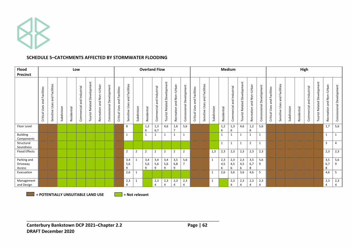
_____________________________________________________________________________ Canterbury Bankstown DCP 2021–Chapter 2.2 Page | 62 DRAFT December 2020
SCHEDULE 5–CATCHMENTS AFFECTED BY STORMWATER FLOODING
Flood Precinct
Low Overland Flow Medium High
Cri
tica
l Use
s an
d F
acili
ties
Sen
siti
ve U
ses
and
Fac
iliti
es
Sub
div
isio
n
Res
iden
tial
Co
mm
erci
al a
nd
Ind
ust
rial
Tou
rist
Rel
ated
De
velo
pm
ent
Rec
reat
ion
an
d N
on
–Urb
an
Co
nce
ssio
nal
De
velo
pm
ent
Cri
tica
l Use
s an
d F
acili
ties
Sen
siti
ve U
ses
and
Fac
iliti
es
Sub
div
isio
n
Res
iden
tial
Co
mm
erci
al a
nd
Ind
ust
rial
Tou
rist
Rel
ated
De
velo
pm
ent
Rec
reat
ion
an
d N
on
–Urb
an
Co
nce
ssio
nal
De
velo
pm
ent
Cri
tica
l Use
s an
d F
acili
ties
Sen
siti
ve U
ses
and
Fac
iliti
es
Sub
div
isio
n
Res
iden
tial
Co
mm
erci
al a
nd
Ind
ust
rial
Tou
rist
Rel
ated
De
velo
pm
ent
Rec
reat
ion
an
d N
on
–Urb
an
Co
nce
ssio
nal
De
velo
pm
ent
Cri
tica
l Use
s an
d F
acili
ties
Sen
siti
ve U
ses
and
Fac
iliti
es
Sub
div
isio
n
Res
iden
tial
Co
mm
erci
al a
nd
Ind
ust
rial
Tou
rist
Rel
ated
De
velo
pm
ent
Rec
reat
ion
an
d N
on
–Urb
an
Co
nce
ssio
nal
De
velo
pm
ent
Floor Level
8 1,2 6
1,3 6,7
4,6 1,6 7
5,6 1,2 6
1,3 6
4,6 1,2 6
5,6 1,7 5,6
Building Components
1 1 1 1 1 1 1 1 1 1 1 1 1
Structural Soundness
1 1 1 2 1 3 4
Flood Effects
2 2 2 2 2 2 2 1,3 2,3 2,3 2,3 2,3 2,3 2,3 2,3
Parking and Driveway Access
3,4 5,6 9
1 3,4 5,6 9
3,4 5,6 9
3,4 5,6 9
3,5 6,8 9
5,6 7
1 2,3 4,5 6
2,3 4,5 6
2,3 4,5 6
3,5 6,7 8
5,6 9
3,5 6,7 8
5,6 9
Evacuation
2,6 1 1 2,6 3,6 3,6 4,6 5 4,6 5
Management and Design
2,3 4
1 2,3 4
2,3 4
2,3 4
2,3 4
1 2,3 4
2,3 4
2,3 4
2,3 4
2,3 4
2,3 4
= POTENTIALLY UNSUITABLE LAND USE = Not relevant

_____________________________________________________________________________ Canterbury Bankstown DCP 2021–Chapter 2.2 Page | 63 DRAFT December 2020
Notes to Table 1. Freeboard: Freeboard equals an additional height of 500mm in the low, medium and high flood risk precincts. Freeboard equals an
additional height of 300mm in the overland flow flood risk precinct. 2. Permissibility of Development: The relevant environmental planning instrument (generally the LEP) identifies development permissible
with consent in various zones in Canterbury Bankstown. However, constraints specific to individual sites may preclude Council granting consent for development on all or part of a site, whether or not there is compliance with Chapter 2.2 of this DCP, and whether or not the use is permissible under the LEP. The above matrix identifies where certain development types will be considered unsuitable due to flood related risks. If development consent is granted, compliance with the controls in Chapter 2.2 of this DCP may also lead to design constraints that could reduce the development yield for the site.
3. Unsuitable Land Uses: Uses identified as "potentially unsuitable" will generally not be considered as a result of their overall
incompatibility with flood risk. Such uses may however be considered where they show compliance with the objectives and the performance criteria of Chapter 2.2 of this DCP. In such cases, these uses will also need to comply with controls as specified by Council.
4. Filling: Filling of a site that is partially affected by flooding (if acceptable to Council) may change the flood risk precinct, and the associated
development controls that apply to development on the site. 5. Multiple Flood Risk Precincts: Development controls relate to the flood risk precinct identified for the site. Where a site has two or more
flood risk categories the relevant sets of controls apply. 6. Fencing: Refer to section 5 of Chapter 2.2 of this DCP for planning considerations involving only the erection of a fence. Any fencing that
forms part of a proposed development is subject to the relevant flood effect and structural soundness considerations of the relevant category.

_____________________________________________________________________________ Canterbury Bankstown DCP 2021–Chapter 2.2 Page | 64 DRAFT December 2020
7. Critical Uses and Facilities: Uses defined as "critical uses and facilities" are considered "potentially unsuitable" in the high and medium
precinct and on all land up to the edge of the floodplain. 8. Flowpaths: Council may have undertaken mapping showing "major overland flowpaths" (see definitions) in some areas. This mapping is
not exhaustive, and in some cases a site specific flood study may be necessary to determine the presence of overland flow paths. Council may require that these flowpaths remain undeveloped completely or partially, to provide for the conveyance of floodwaters. Some overland flow paths are protected by an easement, and in these cases, development would not be permitted over the easement. Refer to Council to determine whether these areas have been mapped for particular catchments and/ or properties.
9. Floor Levels for Commercial and Industrial Uses: Regarding the floor level control for commercial and industrial uses, it is generally
expected that the habitable floor level should be at the 100-year flood level plus freeboard. A lower floor level could be considered where compliance with this standard would result in complications with designing and operating the development, as well as any significant inconsistencies with the floor levels of existing developments.

_____________________________________________________________________________ Canterbury Bankstown DCP 2021–Chapter 2.2 Page | 65 DRAFT December 2020
Floor Level 1. Non–habitable floor levels should be no lower than the 20–year flood unless justified by
a specific assessment. 2. All habitable floor levels to be equal to or greater than the 100–year flood level plus
freeboard. 3. The level of habitable floor areas to be equal to or greater than the 100–year flood level
plus freeboard. If this is impractical for development in a Business zone the floor level should be as high as possible.
4. All floor levels to be equal to or greater than the 20–year flood unless justified by
specific assessment; 5. Floor levels to be greater than or equal to the prescribed floor level (which is the floor
level that applies to that particular type of development). Where this is not practical due to the compatibility with the height of adjacent buildings, or with the floor level of existing buildings, or the need for access by persons with disabilities, a lower floor level may be considered. In these circumstances, the floor level is to be as high as practical. When undertaking alterations or additions, the floor level can be the same as the existing floor level. However in all cases, any storage of dangerous goods, plant etc. should be above the prescribed floor level.
6. A restriction on the use of the land is to be registered on the Certificate of Title where
the lowest floor level is elevated more than 1.5 metres above finished ground level, requiring that the undercroft area is not to be enclosed. The use of roller shutters, hit and miss brickwork and similar methods is however permissible where there is no significant flood impact. Non–habitable uses (laundry, toilet, bathroom and similar uses) can be enclosed where there is no significant flood impact.
7. Habitable floor levels to be equal to or greater than the 100–year flood level plus
freeboard where possible or otherwise no lower than the 20–year flood unless justified by specific assessment
Building Components 1. All structures to have flood compatible building components below the 100–year flood
level plus freeboard.
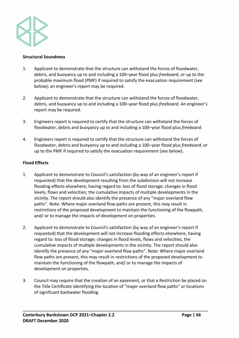
_____________________________________________________________________________ Canterbury Bankstown DCP 2021–Chapter 2.2 Page | 66 DRAFT December 2020
Structural Soundness 1. Applicant to demonstrate that the structure can withstand the forces of floodwater,
debris, and buoyancy up to and including a 100–year flood plus freeboard, or up to the probable maximum flood (PMF) if required to satisfy the evacuation requirement (see below); an engineer’s report may be required.
2. Applicant to demonstrate that the structure can withstand the forces of floodwater,
debris, and buoyancy up to and including a 100–year flood plus freeboard. An engineer’s report may be required.
3. Engineers report is required to certify that the structure can withstand the forces of
floodwater, debris and buoyancy up to and including a 100–year flood plus freeboard. 4. Engineers report is required to certify that the structure can withstand the forces of
floodwater, debris and buoyancy up to and including a 100–year flood plus freeboard, or up to the PMF if required to satisfy the evacuation requirement (see below).
Flood Effects 1. Applicant to demonstrate to Council's satisfaction (by way of an engineer’s report if
requested) that the development resulting from the subdivision will not increase flooding effects elsewhere, having regard to: loss of flood storage; changes in flood levels, flows and velocities; the cumulative impacts of multiple developments in the vicinity. The report should also identify the presence of any "major overland flow paths". Note: Where major overland flow paths are present, this may result in restrictions of the proposed development to maintain the functioning of the flowpath, and/ or to manage the impacts of development on properties.
2. Applicant to demonstrate to Council's satisfaction (by way of an engineer’s report if
requested) that the development will not increase flooding effects elsewhere, having regard to: loss of flood storage; changes in flood levels, flows and velocities; the cumulative impacts of multiple developments in the vicinity. The report should also identify the presence of any "major overland flow paths". Note: Where major overland flow paths are present, this may result in restrictions of the proposed development to maintain the functioning of the flowpath, and/ or to manage the impacts of development on properties.
3. Council may require that the creation of an easement, or that a Restriction be placed on
the Title Certificate identifying the location of "major overland flow paths" or locations of significant backwater flooding.

_____________________________________________________________________________ Canterbury Bankstown DCP 2021–Chapter 2.2 Page | 67 DRAFT December 2020
Parking and Driveway Access 1. Applicant to show that car parking and driveway access for any development resulting
from the subdivision can be provided in accordance with this DCP. 2. The minimum surface level of open car parking spaces or carports shall be as high as
practical, and not below: (a) the 20 year flood level; or (b) the level of the crest of the road at the location where the site has access
(whichever is the lower).
In the case of garages, the minimum surface level shall be as high as practical but no lower than the 20–year flood. Surface levels should also be determined having regard to the control Number 4 below relating to depths of inundation over driveways.
3. Garages capable of accommodating more than 3 vehicles on land zoned for urban
purposes, or enclosed car parking must be protected from inundation from the 100 year flood.
4. The level of the driveway providing access between the road and the parking spaces
should be as high as practical, and not lower than 0.3 metres below the 100–year flood level. However, Council may consider a lower level for the driveway in the following circumstances, where risk to human life is not compromised: (a) Where the road is lower than the parking space, no part of the driveway should be
inundated to a greater depth than the roadway. (b) Where the car parking space is lower than the road, the depth of inundation over
the driveway must not be greater than the car park inundation depth, and the driveway must rise continuously in an egress direction.
(c) Where the car parking space and road are both below the 100–year flood level, the depth of inundation over the driveway must not be greater than the depth at either the car parking space or the road. Where feasible, the driveway should rise continuously in the egress direction.
5. Enclosed car parking and car parking areas capable of accommodating more than 3
vehicles (other than on rural zoned land with a floor level below the 20 year flood level or more than 0.8 metres below the 100 year flood level shall have adequate warning signs, signage and exits.
6. Restraints or vehicle barriers to be provided to prevent floating vehicles leaving the site
in a 100–year flood.

_____________________________________________________________________________ Canterbury Bankstown DCP 2021–Chapter 2.2 Page | 68 DRAFT December 2020
7. The minimum surface level of open car parking spaces, carports or garages shall be as
high as practical. 8. The driveway providing access between the road and the parking space shall be as high
as practical and generally rising in the egress direction. 9. Driveway and parking space levels to be no lower than the design ground floor levels.
Where this is not practical, a lower level may be considered where the risk to human life would not be compromised. In these circumstances, the levels are to be as high as practical, and when undertaking additions or alterations, no lower than the existing level.
Evacuation 1. Applicant to show that evacuation for development resulting from the subdivision can
be provided in accordance with this DCP. 2. Reliable access for pedestrians or vehicles is required from the building, commencing at
a minimum level equal to the lowest habitable floor level to an area of refuge above the PMF. Such a refuge may comprise a minimum of 20% of the gross floor area of the dwelling being above the PMF level. An engineer’s report may be required.
3. Reliable access for pedestrians or vehicles is required. An engineer’s report may be
needed to address this matter and should consider access for pedestrians or vehicles to a publicly accessible location above the 100–year flood level. Where feasible, an area of refuge within the building or development site that is above the PMF level, and which is equal to 20% of the gross floor area of the development, or such other area capable of accommodating the number of people likely to require evacuation.
4. The evacuation requirements of the development are to be considered. An engineer’s
report will be required if circumstances are possible that the evacuation of persons may not be achieved within the effective warning time.
5. An evacuation strategy to be considered and proposals made for improving the
evacuation arrangements to the site in relation to the present situation where possible. Adequate flood warning should be available to allow safe and orderly evacuation without undue reliance on the SES or other authorised emergency personnel.
Options could include the provision of access for pedestrians or vehicles to a publicly accessible location, or an area of refuge equal to at least 20% of the gross floor area, or such other area capable of accommodating the number of people likely to require evacuation that is above the probable maximum flood level.

_____________________________________________________________________________ Canterbury Bankstown DCP 2021–Chapter 2.2 Page | 69 DRAFT December 2020
6. The development should be consistent with any flood evacuation strategy, flood plan or
similar strategy that has been adopted by Council. Management and Design 1. Applicant to demonstrate that development resulting from the subdivision can be
undertaken in accordance with this DCP. 2. A Site Emergency Response Flood Plan is required where floor levels are below the
prescribed floor level (which is the floor level that applies to that particular type of development).
3. Applicant to demonstrate that there is an available area above the 100-year flood level
plus freeboard to store goods. 4. No storage of materials below the prescribed floor level which may cause pollution or
be potentially hazardous during floods.

_____________________________________________________________________________ Canterbury Bankstown DCP 2021–Chapter 2.2 Page | 70 DRAFT December 2020
SECTION 7–EXPLANATORY NOTES ON LODGING APPLICATIONS 7.1 Follow these major steps to lodge the application:
(a) Check the proposal is permissible in the zoning of the land by reference to any applicable environmental planning instruments.
(b) Consider any other relevant planning controls of Council (e.g. controls in any other
relevant part of this DCP).
(c) Determine the applicable floodplain or component thereof (e.g. Georges River, Carinya Road Area) and flood risk precinct (low, medium or high) within which your site is situated. Enquire with Council regarding existing flood risk mapping or whether a site–specific assessment may be warranted (for example, if local overland flooding is a potential problem). A site may be located in more than one precinct and the assessment must consider the controls for each precinct relative to where the site is located. The flow diagram below summarises this consideration process.

_____________________________________________________________________________ Canterbury Bankstown DCP 2021–Chapter 2.2 Page | 71 DRAFT December 2020
(d) Determine the land use category relevant to the development proposal, by firstly confirming how it is defined by the relevant environmental planning instrument and secondly by ascertaining the land use category from Schedule 2.
(e) Assess and document how the proposal will achieve the performance criteria for
development and associated fencing provided by Chapter 2.2 of this DCP.
(f) Check if the proposal will satisfy the prescriptive controls for different land use categories in different flood risk precincts, as specified in the Schedule 3 or 4 depending on which floodplain the site is located.
(g) If the proposal does not comply with the prescriptive controls, determine whether
the performance criteria are nonetheless achieved.
(h) Illustrations provided in this plan to demonstrate the intent of development controls are diagrammatic only. Proposals must satisfy all relevant controls contained in this plan and associated legislation.
(i) The assistance of Council staff or an experienced floodplain consultant may be
required at various steps in the process to ensure that the requirements of this Plan are fully and satisfactorily addressed.
Note: Compliance with all the requirements of this DCP does not guarantee that an application will be approved.
7.2 Information required with an application to address this plan is as follows:
(a) Applications must include information which addresses all relevant controls listed above, and the following matters as applicable.
(b) Applications for Concessional Development (see Schedule 2) to an existing
dwelling on Flood Prone Land shall be accompanied by documentation from a registered surveyor confirming existing floor levels.
(c) Development applications affected by this plan shall be accompanied by a survey
plan showing: (i) The position of the existing building(s) or proposed building(s); (ii) The existing ground levels to Australian Height Datum around the perimeter
of the building and contours of the site; and (iii) The existing or proposed floor levels to Australian Height Datum.

_____________________________________________________________________________ Canterbury Bankstown DCP 2021–Chapter 2.2 Page | 72 DRAFT December 2020
(d) Applications for earthworks, filling of land and subdivision shall be accompanied by a survey plan (with a contour interval of 0.25m) showing relative levels to Australian Height Datum.
(e) For large scale developments, or developments in critical situations, particularly
where an existing catchment based flood study is not available, a flood study using a fully dynamic one or two dimensional computer model may be required. For smaller developments the existing flood study may be used if available and suitable (e.g. it contains sufficient local detail), or otherwise a flood study prepared in a manner consistent with the “Australian Rainfall and Runoff” publication, Council’s Drainage Design Code and the Floodplain Management Manual, will be required. From this study, the following information shall be submitted in plan form: (i) water surface contours; (ii) velocity vectors; (iii) velocity and depth product contours; (iv) delineation of flood risk precincts relevant to individual floodplains; and (v) show both existing and proposed flood profiles for the full range of events
for total development including all structures and works (such as revegetation/ enhancements).
This information is required for the pre–developed and post–developed scenarios.
(f) Where the controls for a particular development proposal require an assessment
of structural soundness during potential floods, the following impacts must be addressed: (i) hydrostatic pressure; (ii) hydrodynamic pressure; (iii) impact of debris; and (iv) buoyancy forces.
Foundations need to be included in the structural analysis.

_____________________________________________________________________________ Canterbury Bankstown DCP 2021–Chapter 2.2 Page | 73 DRAFT December 2020
SECTION 8–DEFINITIONS Adequate warning systems, signage and exits means where the following is provided: (a) an audible and visual alarm system which alerts occupants to the need to evacuate,
sufficiently prior to likely inundation to allow for the safe evacuation of pedestrians and vehicles;
(b) signage to identify the appropriate procedure and route to evacuate; and (c) exits which are located such that pedestrians evacuating any location during any flood
do not have to travel through deeper water to reach a place of refuge above the 100 year flood away from the enclosed car parking.
Average exceedence probability (AEP) means the magnitude of a storm. Average Recurrence Interval (ARI) means the long term average number of years between the occurrence of a flood as big as, or larger than, the selected event. For example, floods with a discharge as great as, or greater than, the 20 year ARI flood event will occur on average once every 20 years. ARI is another way of expressing the likelihood of occurrence of a flood event. Catch drain means a diversion channel constructed above a road or batter to intercept surface water. Channel means a natural stream that conveys water, a ditch or drain excavated for the flow of water. Culvert means one or more adjacent pipes or enclosed conduits for carrying a watercourse beneath a road or other earthworks. Designated flood means the 1 in 100 year flood for the Georges River. Designated flood level means the level reached by a 1 in 100–year flood as advised by the Department of Public Works and Services in 1986. Effective warning time means the time available after receiving advice of an impending flood and before the floodwaters prevent appropriate flood response actions being undertaken. The effective warning time is typically used to move farm equipment, move stock, raise furniture, evacuate people and transport their possessions.

_____________________________________________________________________________ Canterbury Bankstown DCP 2021–Chapter 2.2 Page | 74 DRAFT December 2020
Enclosed car parking means car parking which is potentially subject to rapid inundation, which consequently increases risk to human life and property (such as basement of bunded car parking areas). The following criteria apply for the purposes of determining what is enclosed car parking: (a) flooding of surrounding areas may raise water levels above the perimeter which
encloses the car park (normally the entrance), resulting in rapid inundation of the car park to depths greater than 0.8 metre; and
(b) drainage of accumulated water in the car park has an outflow discharge capacity significantly less than the potential inflow capacity.
Extreme flood means an estimate of the probable maximum flood, which is the largest flood likely to ever occur. Fail safe access for pedestrians means a reliable and permanent system which will allow safe evacuation for pedestrians up to and including the 100 year flood and may include a walkway and stairs designed in accordance with the Building Code of Australia (BCA), or where necessitated by topography, fixed ladders designed in accordance with Australian Standard AS 1657 (AS, 1992), located at or above the 100 year flood level. Fail safe access for motor vehicles means a reliable and permanent system which will allow the safe movement of vehicles during all floods up to and including the 100 year flood. Flood means a relatively high stream flow which overtops the natural or artificial banks in any part of a stream, river, estuary, lake or dam, and/or local overland flooding associated with major drainage as defined by the FDM before entering a watercourse. Note: Consistent with the FDM, this DCP does not apply in the circumstances of local drainage inundation as defined in the FDM and determined by Council. Local drainage problems can generally be minimised by the adoption of urban building controls requiring a minimum difference between finished floor and ground levels. Flood awareness means an appreciation of the likely effects of flooding and a knowledge of the relevant flood warning and evacuation procedures. Flood compatible building components means a combination of measures incorporated in the design and/or construction and alteration of individual buildings or structures subject to flooding, and the use of flood compatible materials for the reduction or elimination of flood damage.

_____________________________________________________________________________ Canterbury Bankstown DCP 2021–Chapter 2.2 Page | 75 DRAFT December 2020
Flood compatible materials means the materials used in building which are resistant to damage when inundated. Flood evacuation strategy means the proposed strategy for the evacuation of areas within effective warning time during periods of flood as specified within any policy of Council, the FRMP, the relevant SES Flood Plan, by advices received from the State Emergency Services (SES) or as determined in the assessment of individual proposals. Flood plan means a management plan prepared in consultation with the State Emergency Services (SES) which demonstrates the means to minimise the likelihood of flood damage, including demonstrated ability to move goods above the flood level within the likely available flood warning time and a strategy to safely evacuate persons on the site. Floodplain Risk Management Plan (FRMP) means a plan prepared for one or more floodplains in accordance with the requirements of the FDM or its predecessor of which this DCP forms part. Floodplain Risk Management Study (FRMS) means a study prepared for one or more floodplains in accordance with the requirements of the FDM or its predecessor. Flood prone land (being synonymous with flood liable and floodplain) is the area of land which is subject to inundation by the probable maximum flood (PMF). Flood proofing means a combination of measures incorporated in the design and/or construction and alteration of individual buildings or structures subject to flooding, for the reduction or elimination of flood damage as indicated in the Floodplain Development Manual. Freeboard means a factor of safety expressed as the height above the design flood level. Freeboard provides a factor of safety to compensate for uncertainties in the estimation of flood levels across the floodplain, such and wave action, localised hydraulic behaviour and impacts that are specific event related, such as levee and embankment settlement, and other effects such as “greenhouse” and climate change. Habitable room means a room used for normal domestic activities that includes a bedroom, living room, lounge room, music room, television room, kitchen, dining room, sewing room, study, playroom and sunroom; but excludes a bathroom, laundry, water closet, food storage pantry, walk-in wardrobe, corridor, hallway, lobby, photographic darkroom, clothes drying room, and other spaces of specialised nature occupied neither frequently nor for extended periods.

_____________________________________________________________________________ Canterbury Bankstown DCP 2021–Chapter 2.2 Page | 76 DRAFT December 2020
Habitable floor area means: (a) in a residential situation: a living or working area, such as a lounge room, dining room,
rumpus room, kitchen, bedroom or workroom; and (b) in an industrial or commercial situation: an area used for offices or to store valuable
possessions susceptible to flood damage in the event of a flood. Hazard means a source of potential harm or a situation with a potential to cause loss. In relation to this plan, the hazard is flooding which has the potential to cause harm or loss to the community. High hazard flood fringe areas means the areas subject to inundation in a designated flood of 1 metre or more, but not including floodway areas, interim floodways, or the special development areas referred to in this DCP. High hazard flood fringe areas means the areas subject to inundation in a designated flood of 1 metre or more. Hydraulic hazard is the hazard as determined by the provisional criteria outlined in the FDM in a 100 year flood event. Interim floodways means the areas subject to current investigations to determine the extent and severity of the flood hazard. In the case of severe hazard, the investigation should determine whether or not flood mitigation measures can and should be introduced to reduce the hazard to that normally associated with high hazard flood fringe areas. This would allow Council to approve new buildings and additions. Only one interim floodway currently exists and this is located in the vicinity of MacLaurin Avenue and Henry Lawson Drive, East Hills. Local overland flooding means inundation by local runoff rather than overbank discharge from a stream, river, estuary, lake or dam. Low hazard flood fringe areas means those areas subject to inundation in a designated flood to a depth of less than 1 metre. 100 year flood means the flood that has a 1% chance of occurring or being exceeded in any year. Probable maximum flood (PMF) means the largest flood that could conceivably occur at a particular location, usually estimated from probable maximum precipitation.
_____________________________________________________________________________ Canterbury Bankstown DCP 2021–Chapter 2.2 Page | 77 DRAFT December 2020
Probable maximum precipitation (PMP) means the greatest depth of precipitation for a given duration meteorologically possible over a given size storm area at a particular location at a particular time of the year, with no allowance made for long-term climatic trends (World Meteorological Organisation, 1986). It is the primary input to the estimation of the probable maximum flood. Probability means a statistical measure of the expected chance of flooding (see ARI). Reliable access during a flood means the ability for people to safely evacuate an area subject to flooding, having regard to the depth and velocity of flood waters, the suitability of the evacuation route, and without a need to travel through areas where water depths increase. Risk means the chance of something happening that will have an impact. It is measured in terms of consequences and probability (likelihood). In the context of this plan, it is the likelihood of consequences arising from the interaction of floods, communities and the environment. Site Emergency Response Flood Plan (not being an SES Flood Plan) is a management plan that demonstrates the ability to safely evacuate persons and include a strategy to move goods above the flood level within the available warning time. This Plan must be consistent with any flood evacuation strategy, flood plan or similar plan adopted by Council. Watercourse means a natural or constructed channel for the flow of water.

_____________________________________________________________________________ Canterbury Bankstown DCP 2021–Chapter 2.3 Page | 1 DRAFT December 2020
Canterbury Bankstown Development Control Plan 2021 Chapter 2 Site Considerations 2.3 Tree Management DRAFT December 2020

_____________________________________________________________________________ Canterbury Bankstown DCP 2021–Chapter 2.3 Page | 2 DRAFT December 2020
CONTENTS Section 1 Introduction………………………………………………………...……………………….. 3 Section 2 Tree Management.............................................................................. 4 Section 3 Definitions………………….…………………………………………………………………. 9

_____________________________________________________________________________ Canterbury Bankstown DCP 2021–Chapter 2.3 Page | 3 DRAFT December 2020
SECTION 1–INTRODUCTION Explanation Trees are a vital component of the urban environment of Canterbury Bankstown. Trees provide essential ecological, environmental, health, heritage and amenity values; all contributing to make Canterbury Bankstown a pleasant place to live and work. As well as these direct values to residents, trees have equally important values in their own right in maintaining and enhancing biodiversity and natural ecosystems and processes. The entirety of the trees and large woody shrubs that grow on public and private land form Canterbury Bankstown’s urban forest. Council’s vision is for a clean, green, healthy and biodiverse natural environment. A canopy of trees that shelter and beautify Canterbury Bankstown is an integral component of that vision. Canterbury Bankstown Development Control Plan 2021 supports Council’s vision by providing objectives and development controls for tree management and is made pursuant to the State Environmental Planning Policy (Vegetation in Non–Rural Areas) 2017. Canterbury Bankstown Development Control Plan 2021 must be read in conjunction with the Tree Management Manual. The Manual supports Canterbury Bankstown Development Control Plan 2021 by providing additional requirements in relation to tree management, tree pruning and tree planting. Objectives O1 To sustainably manage the tree resources to improve the visual, physical and
environmental amenity of Canterbury Bankstown. O2 To promote a healthy urban forest and urban tree canopy. O3 To promote the use of professional standards and best practices in tree management. O4 To list the controls for the pruning, removal and replacement planting of trees.
_____________________________________________________________________________ Canterbury Bankstown DCP 2021–Chapter 2.3 Page | 4 DRAFT December 2020
SECTION 2–TREE MANAGEMENT Explanation This section provides the development controls for the pruning, removal and replacement planting of trees in Canterbury Bankstown. This section applies to the clearing of non–native vegetation, and the clearing of native vegetation that do not exceed the biodiversity offset scheme threshold. Development Controls Works requiring a permit 2.1 A person must not cut down, fell, uproot, kill, poison, ringbark, burn or otherwise
destroy, lop or otherwise remove a substantial part of any prescribed tree defined in clause 2.3 or carry out excavation and earthworks within the tree protection zone except with a permit from Council and subject to any conditions specified in the permit.
2.2 Development consent is required to remove any tree:
(a) located on a site listed as a heritage item in Schedule 5 of Canterbury Bankstown Local Environmental Plan 2021; or
(b) located on land included on the Terrestrial Biodiversity Map under Canterbury Bankstown Local Environmental Plan 2021.
Prescribed trees 2.3 Chapter 2.3 of this DCP applies to the following trees:
(a) all trees that are 5 metres or more in height; and (b) all mangroves, regardless of size; and (c) all trees, regardless of size, listed as Vulnerable or Endangered or a component of
an Endangered Ecological Community listed under the Biodiversity Conservation Act 2016; and
(d) all trees, regardless of size, listed under the Environmental Protection and Biodiversity Conservation Act 1999; and
(e) all trees, regardless of size, located on land included on the Terrestrial Biodiversity Map under Canterbury Bankstown Local Environmental Plan 2021; and
(f) all trees, regardless of size, located on sites listed as a heritage item in Schedule 5 of Canterbury Bankstown Local Environmental Plan 2021; and
(g) all trees, regardless of size, located in the foreshore area under Canterbury Bankstown Local Environmental Plan 2021.

_____________________________________________________________________________ Canterbury Bankstown DCP 2021–Chapter 2.3 Page | 5 DRAFT December 2020
Exemptions 2.4 Despite clause 2.3, Chapter 2.3 of this DCP does not apply to:
(a) trees located within 3 metres of the external wall of an approved dwelling, not including a secondary dwelling. The distance shall be measured from the external wall of the approved dwelling to the centre of the trunk of the tree at 1.4 metres above ground level;
(b) the following tree species:
Scientific Name Common Name
Acacia baileyana Cootamundra Wattle Acacia podalyriifolia Queensland Silver Wattle Acacia saligna Golden Wattle Ailanthus altissima Tree of Heaven Bambusa spp. Bamboo Celtis sinensis Hackberry Cinnamomum camphora Camphor Laurel (less than 10 metres in height) Citrus limon cvs. Lemon Tree Citrus reticulata cvs. Mandarin Tree Citrus sinensis cvs Orange Tree Citrus x paradisi cvs Grapefruit Tree Eriobotrya japonica Loquat Tree Erythrina x sykseii Common Coral Tree Eucalyptus nicholii Narrow–leafed Peppermint Eucalyptus scoparia Willow Gum Ficus elastica and cvs. Rubber Tree Gleditsia triacanthos Honey Locust Ligustrum lucidum Broad–leaf Privet Ligustrum sinense Narrow–leaf Privet Liquidambar styraciflua Liquidambar Malus domestica and cvs. Apple Tree Mangifera indica Mango Tree Morus spp. Mulberry Tree Musa spp. Banana Olea europaea subspecies africana African Olive Phoenix canariensis Canary Island Date Palm
(with a trunk less than 4 metres in height) Phyllostachys spp. Rhizomatous Bamboo Pinus radiata Radiata Pine Tree Populus spp. Poplars Prunus avium / P. cerasus and cvs. Cherry Tree Prunus persica and cvs. Peach Tree

_____________________________________________________________________________ Canterbury Bankstown DCP 2021–Chapter 2.3 Page | 6 DRAFT December 2020
Prunus spp. and cvs. Plum Tree Prunus spp. and cvs. Apricot Tree Pyrus communis and cvs. European Pear Robinia pseudoacacia and cvs Robinia Salix spp. Willow Tree Schefflera actinophylla Umbrella Tree Schinus terebinthifolius Broad–leaf Pepper Tree Syagrus romanzoffiana Cocos Palm Toxicodendron succedaneum Rhus Tree X Cupressocyparis leylandii and cvs. Leyland Cypress
(c) plants declared a weed under the Biosecurity Act 2015; (d) dead trees where they are not required as habitat for native fauna; (e) dangerous trees where it can be proved by the owner to Council’s satisfaction that
pruning or removal is the only reasonable option to avoid an imminent threat to human life or property;
(f) recognised horticultural varieties of trees grown for fruit production; (g) selective pruning of up to a total of 10% of the crown of an indigenous tree and up
to a total of 20% of the crown of an exotic tree species over a 12 month period. Branches pruned must be no greater than 150 mm in diameter. Pruning works must comply with Australian Standard AS 4373–2007 Pruning of amenity trees, and consist of the following pruning classes only:
Crown Maintenance:
• Deadwooding
• Crown thinning
• Selective pruning
Crown Modification:
• Reduction pruning
• Crown lifting
• Remedial pruning
• Line clearance
Note: Clause 2.4 (g) does not apply to any tree:
• listed as Vulnerable or Endangered or a component of an Endangered Ecological Community listed under the Biodiversity Conservation Act 2016; or
• listed under the Environmental Protection and Biodiversity Conservation Act 1999; or
• located on a site listed as a heritage item in Schedule 5 of Canterbury Bankstown Local Environmental Plan 2021; or

_____________________________________________________________________________ Canterbury Bankstown DCP 2021–Chapter 2.3 Page | 7 DRAFT December 2020
• located on land included on the Terrestrial Biodiversity Map under Canterbury Bankstown Local Environmental Plan 2021; or
• located in a conservation corridor; or
• located in the foreshore area under Canterbury Bankstown Local Environmental Plan 2021;
(h) pruning of palms to remove fruit and dead fronds; (i) trees listed for removal under a current development consent; (j) tree works lawfully conducted in accordance with the Forestry Act 1916,
Telecommunications Act 1997, Airports Act 1996, Roads Act 1993, Rural Fires Act 1997, Electricity Supply Act 1995, State Emergency and Rescue Management Act 1989, Surveying and Spatial Information Act 2002, and an Order issued under the Tree (Disputes between Neighbours) Act 2006.
Matters for consideration 2.5 Council will consider, but not be limited to, the following matters when determining an
application to prune or remove a tree: (a) the suitability of the tree for site conditions; (b) the condition of the tree; (c) the contribution of the tree to the local landscape; (d) the environmental contribution of the tree; (e) the impact of the tree on the property and associated infrastructure; (f) the amenity of the occupants of the site.
Note: The dropping of leaves, flowers, fruits, seeds or small elements of deadwood are part of a trees normal life cycle, and ordinarily will not provide the basis for the pruning or removal of the tree.
Approval granted by Council 2.6 A permit granted by Council is valid for a period of 12 months from the date of issue. 2.7 The permit must be issued to the owner of the site on which the tree is located. 2.8 A copy of the permit must be on site during the course of the works, and must be
produced by the person undertaking the work on demand by a Council officer. 2.9 A permit granted by Council or development consent may be subject to the requirement
to plant suitable replacement trees on the site, offset tree planting, or any other conditions deemed suitable by Council. The replacement planting is to be completed within 28 days of the tree removal works, or as otherwise specified by Council.

_____________________________________________________________________________ Canterbury Bankstown DCP 2021–Chapter 2.3 Page | 8 DRAFT December 2020
Refusal 2.10 Council may refuse in full or in part an application made under this DCP. Appeals 2.11 An applicant may appeal Councils decision if they believe:
(a) Council has erred in its judgement; or (b) Council’s decision is harsh or unreasonable; or (c) additional information has become available subsequent to the inspection by
Council.
An appeal must be lodged within three months of the date of Council’s determination. Council may require the appellant to provide reports or other suitable documentation from appropriately qualified consultants or experts relevant to the basis of the appeal.
Penalties 2.12 A person(s) who contravenes or causes or permits the contravention of this DCP shall be
guilty of an offence and liable for prosecution.
A person found guilty of contravening or causing or permitting the contravention of this DCP shall be liable for a fine of up to 10,000 Penalty Units or as increased from time to time. In addition to a fine, the Court may also require the person to replace the damaged or destroyed tree(s) and maintain such tree(s) until maturity.

_____________________________________________________________________________ Canterbury Bankstown DCP 2021–Chapter 2.3 Page | 9 DRAFT December 2020
SECTION 3–DEFINITIONS Approved Dwelling means, for the purpose of Chapter 2.3 of this DCP, an approved dwelling means a dwelling with development consent or complying development consent under the Environmental Planning and Assessment Act 1979 to the satisfaction of Council. Arborist means a person with training to AQF Level 3 in Arboriculture, or above, or equivalent recognised and relevant experience. Australian Qualification Framework (AQF) means a national framework for education and training in Australia. Australian Standard AS 4373–2007 Pruning of amenity trees means the standard that specifies methods of pruning and gives guidance on correct and uniform practices. Australian Standard AS 4970–2009 Protection of trees on development sites means the standard that specifies principles for protecting trees on land subject to development. Biodiversity Offset Scheme (BOS) Threshold means the clearing of native vegetation on land included on the Biodiversity Values Map, or the clearing of an area of native vegetation exceeding the following threshold: Minimum lot size of land Area of clearing
Less than 1 hectare 0.25 hectare or more Less than 40 hectares but not less than 1 hectare 0.5 hectare or more Less than 1000 hectares but not less than 40 hectares 1 hectare or more 1000 hectares or more 2 hectares or more
Biodiversity Values Map (BVM) means the Biodiversity Values Map, which identifies land with high biodiversity value as defined by the Biodiversity Conservation Regulation 2017. Consultant Arborist means a person with training to AQF Level 5 in Arboriculture, and/ or equivalent experience. Crown means the portion of the tree consisting of branches and leaves and any part of the trunk (or stem) from which branches arise. Crown Lifting means the removal of lower branches. Crown Thinning means reducing the crown density of the tree by removing smaller branches and retaining the major structural branches.
_____________________________________________________________________________ Canterbury Bankstown DCP 2021–Chapter 2.3 Page | 10 DRAFT December 2020
Dead Tree means a tree that no longer has a functioning xylem and/ or phloem system, evidenced by permanent leaf loss, permanent desiccation of branches and stems, and bark peeling off back to the sapwood. Deadwood means dead branches within the crown of a tree. Deadwooding means the removal of dead branches. Dwelling means, for the purpose of Chapter 2.3 of this DCP, a room or suite of rooms occupied or used or so constructed or adapted as to be capable of being occupied as a separate domicile, but does not include permanent fixed structures such as deck, garages and similar structures that are attached to the building. Exotic Tree means a tree species not originating from Australia. Indigenous Tree means a tree species that existed in New South Wales before European settlement. Injury means damage to the trunk, crown or root system of a tree or any other activity that is likely to compromise the health and/or structure of the tree, including trenching, excavating or soil level changes within the tree protection zone (TPZ) of the tree. Line Clearance means pruning to maintain safety clearances around overhead electricity supply infrastructure. Lop means cutting branches or stems between branch unions or internodes. Native Vegetation means any of the following types of plants native (established prior to European settlement) to New South Wales: (a) Trees,(including any sapling or shrub or any scrub), (b) Understorey plants, (c) Groundcover (being any type of herbaceous vegetation), (d) Plants occurring in wetland. Does not include marine vegetation. Prescribed Tree means a tree listed under clause 2.3 of Chapter 2.3 of this DCP. Prune means the systematic removal of branches. Pruning is not lopping, topping, or the cutting back of branches flush with the stem or trunk. Reduction Pruning means reducing the length of a branch by pruning it back to an internal branch or stem.

_____________________________________________________________________________ Canterbury Bankstown DCP 2021–Chapter 2.3 Page | 11 DRAFT December 2020
Remedial Pruning means the removal of diseased, damaged or lopped branches back to undamaged or healthy tissue on trees that have already lost their natural structure due to disease, storm damage or other mechanical injury. Ringbark means a circumferential cut made around the trunk of a tree which removes a band of tissue to the depth of and including the cambium. Selective Pruning means pruning or removing branches that are causing a specific problem. Structural Root Zone (SRZ) means the area required for tree stability. The SRZ is a radial distance measured from the trunk of the tree calculated in accordance with Section 3 of Australian Standard AS 4970–2009 Protection of trees on development sites. Top means reducing the height of a tree by lopping the branches or stems. Tree means, for the purpose of Chapter 2.3 of this DCP, a long lived perennial plant greater than 5 metres in height with one or relatively few main stems or trunks. Tree Protection Zone (TPZ) means the area above and below ground required for tree viability. The TPZ is a radial distance measured from the trunk of the tree calculated in accordance with Section 3 of Australian Standard AS 4970–2009 Protection of trees on sites. Tree Works means works affecting the form, structure or crown of a tree, including, but not limited to, root cutting, lopping, crown lifting, reduction pruning, selective pruning, crown thinning, remedial pruning and complete tree removal. Urban Forest means the totality of trees and shrubs on all public and private land in and around urban areas (including bushland, parkland, gardens, and street trees) and is measured as a canopy cover percentage of the total area, and is recognised as a primary component of the urban ecosystem (Local Government NSW Urban Forestry Policy).