camino zamorano - portugues...camino zamorano - portugues ‣ zamora-almendra-fonfria-alcañices-...
TRANSCRIPT
Camino Zamorano - Portugues
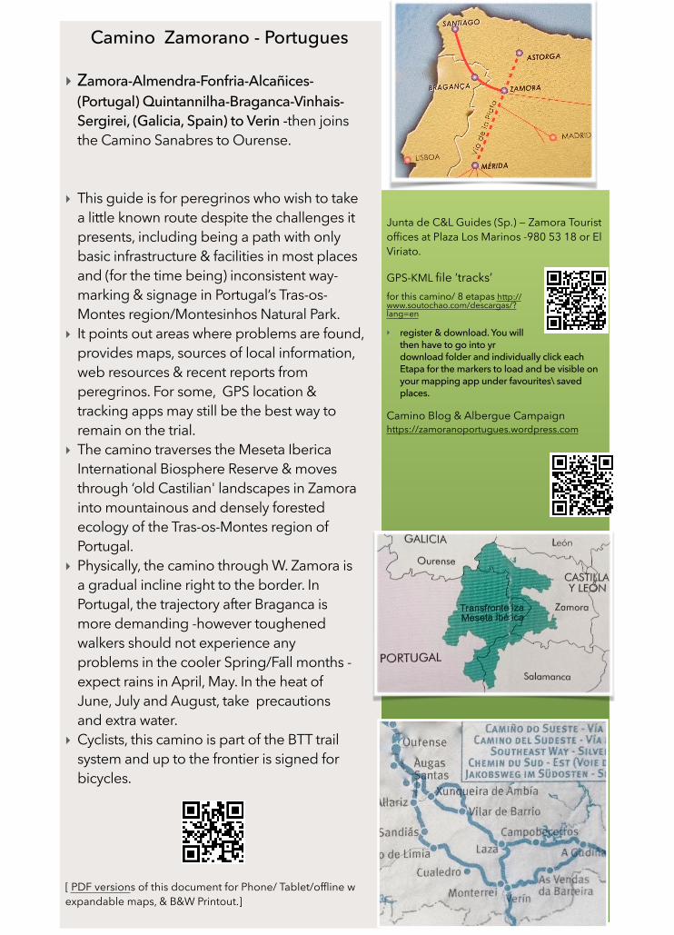
‣ Zamora-Almendra-Fonfria-Alcañices-(Portugal) Quintannilha-Braganca-Vinhais-Sergirei, (Galicia, Spain) to Verin -then joins the Camino Sanabres to Ourense.
‣ This guide is for peregrinos who wish to take a little known route despite the challenges it presents, including being a path with only basic infrastructure & facilities in most places and (for the time being) inconsistent way-marking & signage in Portugal’s Tras-os-Montes region/Montesinhos Natural Park.
‣ It points out areas where problems are found, provides maps, sources of local information, web resources & recent reports from peregrinos. For some, GPS location & tracking apps may still be the best way to remain on the trial.
‣ The camino traverses the Meseta Iberica International Biosphere Reserve & moves through ‘old Castilian' landscapes in Zamora into mountainous and densely forested ecology of the Tras-os-Montes region of Portugal.
‣ Physically, the camino through W. Zamora is a gradual incline right to the border. In Portugal, the trajectory after Braganca is more demanding -however toughened walkers should not experience any problems in the cooler Spring/Fall months -expect rains in April, May. In the heat of June, July and August, take precautions and extra water.
‣ Cyclists, this camino is part of the BTT trail system and up to the frontier is signed for bicycles.
[ PDF versions of this document for Phone/ Tablet/offline w expandable maps, & B&W Printout.]
Junta de C&L Guides (Sp.) — Zamora Tourist offices at Plaza Los Marinos -980 53 18 or El Viriato.
GPS-KML file ‘tracks’ for this camino/ 8 etapas http://www.soutochao.com/descargas/?lang=en
‣ register & download. You will then have to go into yr download folder and individually click each Etapa for the markers to load and be visible on your mapping app under favourites\ saved places.
Camino Blog & Albergue Campaign https://zamoranoportugues.wordpress.com
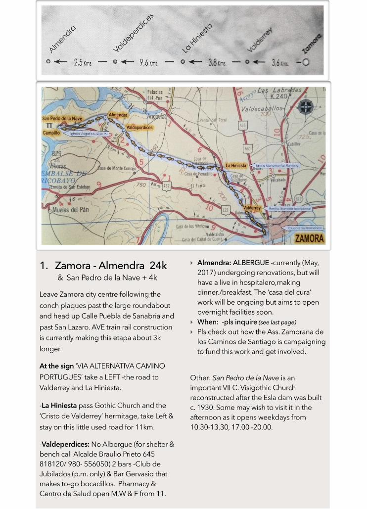
1. Zamora - Almendra 24k & San Pedro de la Nave + 4k
Leave Zamora city centre following the conch plaques past the large roundabout and head up Calle Puebla de Sanabria and past San Lazaro. AVE train rail construction is currently making this etapa about 3k longer.
At the sign ‘VIA ALTERNATIVA CAMINO PORTUGUES’ take a LEFT -the road to Valderrey and La Hiniesta.
-La Hiniesta pass Gothic Church and the ‘Cristo de Valderrey’ hermitage, take Left & stay on this little used road for 11km.
-Valdeperdices: No Albergue (for shelter & bench call Alcalde Braulio Prieto 645 818120/ 980- 556050) 2 bars -Club de Jubilados (p.m. only) & Bar Gervasio that makes to-go bocadillos. Pharmacy & Centro de Salud open M,W & F from 11.
‣ Almendra: ALBERGUE -currently (May, 2017) undergoing renovations, but will have a live in hospitalero,making dinner./breakfast. The ‘casa del cura’ work will be ongoing but aims to open overnight facilities soon.
‣ When: -pls inquire (see last page) ‣ Pls check out how the Ass. Zamorana de
los Caminos de Santiago is campaigning to fund this work and get involved.
Other: San Pedro de la Nave is an important VII C. Visigothic Church reconstructed after the Esla dam was built c. 1930. Some may wish to visit it in the afternoon as it opens weekdays from 10.30-13.30, 17.00 -20.00.
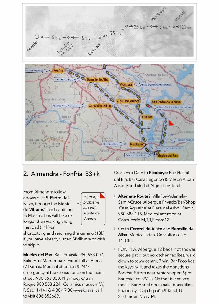
2. Almendra - Fonfria 33+k
From Almendra follow arrows past S. Pedro de la Nave, through the Monte de Viboras* and continue to Muelas. This will take 6k longer than walking along the road (11k) or shortcutting and rejoining the camino (13k) if you have already visited SPdlNave or wish to skip it.
Muelas del Pan: Bar Tomasita 980 553 007. Bakery c/ Marrarrina 7, Foodstuff at Enma c/ Damas. Medical attention & 24/7-emergency at the Consultorio on the main street -980 553 300. Pharmacy c/ San Roque 980 553 224. Ceramics museum W, F, Sat.11-14h & 4.30-17.30 -weekdays, call to visit 606 352669.
Cross Esla Dam to Ricobayo: Eat: Hostal del Rio, Bar Casa Segundo & Meson Alba Y Aliste. Food stuff at Algelica c/ Toral.
‣ Alternate Route?: Villaflor-Videmala-Samir-Cruce. Albergue Privado/Bar/Shop ‘Casa Agustina’ at Plaza del Arbol, Samir, 980 688 115. Medical attention at Consultorio M,T,T,F from12.
‣ On to Cerezal de Aliste and Bermillo de Alba: Medical atten. Consultorio T, F, 11-13h.
‣ FONFRIA: Albergue 12 beds, hot shower, secure patio but no kitchen facilites, walk down to town centre, 7min. Bar Paco has the keys, wifi, and takes the donations. Foodstuff from nearby store open 5pm. Bar Estanco c/Villa. Neither bar serves meals. Bar Angel does make bocadillos. Pharmacy.. Caja España,& Rural, B. Santander. No ATM.
*signage problems around Monte de Viboras.
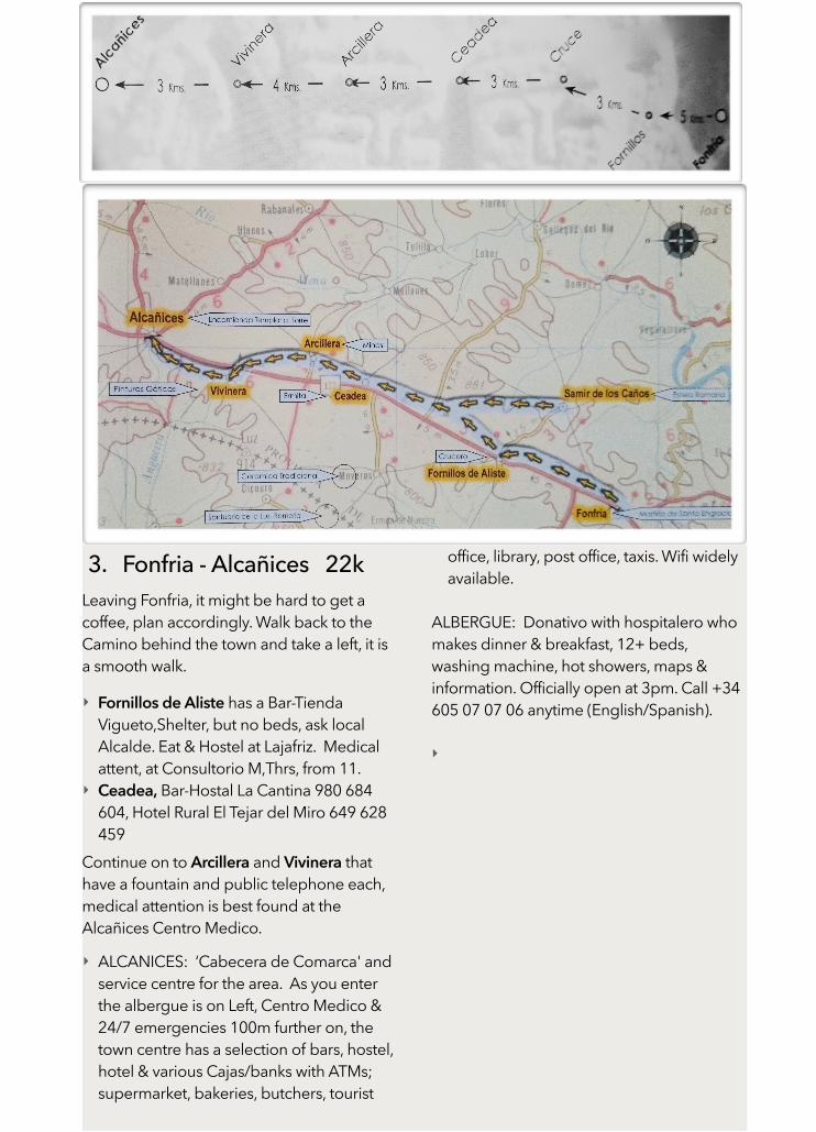
3. Fonfria - Alcañices 22k Leaving Fonfria, it might be hard to get a coffee, plan accordingly. Walk back to the Camino behind the town and take a left, it is a smooth walk.
‣ Fornillos de Aliste has a Bar-Tienda Vigueto,Shelter, but no beds, ask local Alcalde. Eat & Hostel at Lajafriz. Medical attent, at Consultorio M,Thrs, from 11.
‣ Ceadea, Bar-Hostal La Cantina 980 684 604, Hotel Rural El Tejar del Miro 649 628 459
Continue on to Arcillera and Vivinera that have a fountain and public telephone each, medical attention is best found at the Alcañices Centro Medico.
‣ ALCANICES: ‘Cabecera de Comarca' and service centre for the area. As you enter the albergue is on Left, Centro Medico & 24/7 emergencies 100m further on, the town centre has a selection of bars, hostel, hotel & various Cajas/banks with ATMs; supermarket, bakeries, butchers, tourist
office, library, post office, taxis. Wifi widely available.
ALBERGUE: Donativo with hospitalero who makes dinner & breakfast, 12+ beds, washing machine, hot showers, maps & information. Officially open at 3pm. Call +34 605 07 07 06 anytime (English/Spanish).
‣
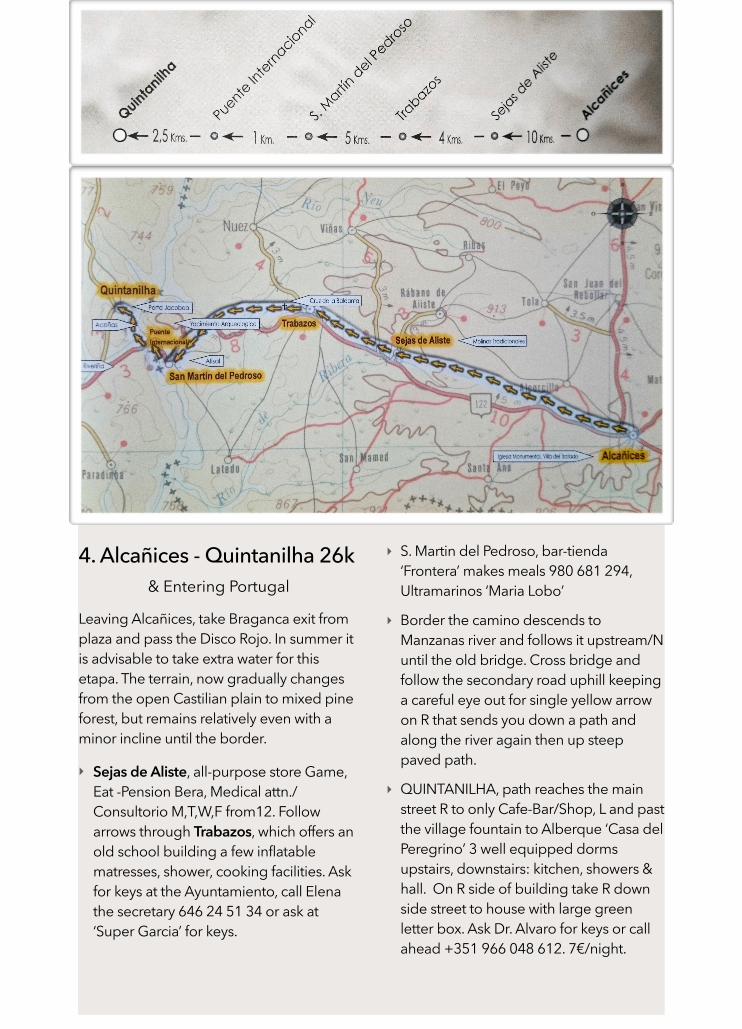
4. Alcañices - Quintanilha 26k & Entering Portugal
Leaving Alcañices, take Braganca exit from plaza and pass the Disco Rojo. In summer it is advisable to take extra water for this etapa. The terrain, now gradually changes from the open Castilian plain to mixed pine forest, but remains relatively even with a minor incline until the border.
‣ Sejas de Aliste, all-purpose store Game, Eat -Pension Bera, Medical attn./Consultorio M,T,W,F from12. Follow arrows through Trabazos, which offers an old school building a few inflatable matresses, shower, cooking facilities. Ask for keys at the Ayuntamiento, call Elena the secretary 646 24 51 34 or ask at ‘Super Garcia’ for keys.
‣ S. Martin del Pedroso, bar-tienda ‘Frontera’ makes meals 980 681 294, Ultramarinos ‘Maria Lobo’
‣ Border the camino descends to Manzanas river and follows it upstream/N until the old bridge. Cross bridge and follow the secondary road uphill keeping a careful eye out for single yellow arrow on R that sends you down a path and along the river again then up steep paved path.
‣ QUINTANILHA, path reaches the main street R to only Cafe-Bar/Shop, L and past the village fountain to Alberque ‘Casa del Peregrino’ 3 well equipped dorms upstairs, downstairs: kitchen, showers & hall. On R side of building take R down side street to house with large green letter box. Ask Dr. Alvaro for keys or call ahead +351 966 048 612. 7€/night.
Pinga -Cafe cortado, Petingas -Sardines.Francesinhas -large sandwich for the hungry. Bombeiros -Fire stations you can sleep at. Posadas de Juventude -Portugal’s system of national albergues—about 10€ /N. Cerveja Letra, Dos Corvos & Mean Sardine, Sagres, Super Bock -Beer.
In Portugal arrows on this camino may be extremely faded, may occasionally be ‘false’, pointing in the wrong direction be missing altogether where much needed.
Portugal Tras-os-Montes
Quinantilha- Braganca-Vinhais- Sergirei & Verin, Galicia
Braganca Turist Office Av. Cidade de Zamora, just past the gas sta. +351 273 381 273
Montesinhos Natural Park is the core of the Meseta Iberica World Biosphere Reserve www. biospfera-mesetaiberica.com/
‣ For GPS location and ‘KML tracks’ along the Camino visit http://www.soutochao.com/descargas/?lang=en, register & download. You will then have to go into yr download folder and individually click each Etapa for the markers to load and be visible on your mapping app under favourites\ saved places.
MAP/ GPS
‣ Osmand free app / offline & gps ‣ maps.me / offline & gps ‣ Orux GPS map app
‣‣‣‣
…the last signpost after pedroso is turned 180 degrees. it says "international brodge 1,1 km" but shows opposite direction.
…you can get a stamp from the guardia civil station just after the bridge. you can also get one from the cafe 'frontera' just before the bridge but have to bring ur own ink 'coz the stamp's dry. not so the members of the dubious profession hangin' round there.…one arrow on a lamp post after the bridge then i lost it and walked on the paved road all along the crossing w ip4 and then further up to quintanilha. the bartender in cafe 'stop' calld for me. washing machine very nice, really needed for my sleeping bag after 38 days. …from Q on lost the arrows after exit from the village so walked up to the paved road continued till the arrows came back n took me eventually away for a lil shortcut to the nxt place Refega. didn't find a bar. …from R to Palacios the road is absolutely beautiful, marvellous with the lil stream. but the signs are often barely visible. i think i made it all the way thru on the right track but often needed some detective work n guessing n faith haha. certainly ready for an an overhaul if you wanna advertise it to wider audience. no bar, maybe if you leave the way for the village nxt door …from P to Gimonde. applies the same - needs overhaul. took a wrong turn but already had the sight of braganca so just kept walking n..soon gimonde came to sight i mean it couldnt had been none other so i arrived on a diff way. from G to brabanca i missed the exit from G so ended up following the paved road till the arrows came back. after it was ok. but i would still repaint them, often not very visible. [peregrino number 7]
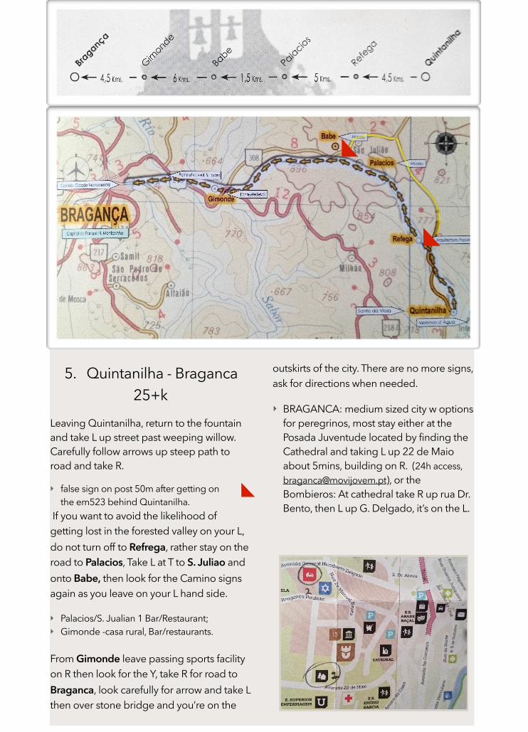
5. Quintanilha - Braganca 25+k
Leaving Quintanilha, return to the fountain and take L up street past weeping willow. Carefully follow arrows up steep path to road and take R.
‣ false sign on post 50m after getting on the em523 behind Quintanilha.
If you want to avoid the likelihood of getting lost in the forested valley on your L, do not turn off to Refrega, rather stay on the road to Palacios, Take L at T to S. Juliao and onto Babe, then look for the Camino signs again as you leave on your L hand side.
‣ Palacios/S. Jualian 1 Bar/Restaurant; ‣ Gimonde -casa rural, Bar/restaurants.
From Gimonde leave passing sports facility on R then look for the Y, take R for road to Braganca, look carefully for arrow and take L then over stone bridge and you’re on the
outskirts of the city. There are no more signs, ask for directions when needed.
‣ BRAGANCA: medium sized city w options for peregrinos, most stay either at the Posada Juventude located by finding the Cathedral and taking L up 22 de Maio about 5mins, building on R. (24h access, [email protected]), or the Bombieros: At cathedral take R up rua Dr. Bento, then L up G. Delgado, it’s on the L.
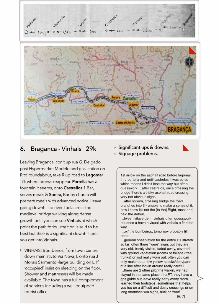
6. Braganca - Vinhais 29k
Leaving Braganca, con’t up rua G. Delgado past Hypermarket Modelo and gas station on R to roundabout, take R up road to Lagomar -7k where arrows reappear. Portella has a fountain it seems, onto Castrellos 1 Bar, serves meals & Soeira, Bar by church will prepare meals with advanced notice. Leave going downhill to river Tuela cross the medieval bridge walking along dense growth until you can see Vinhais at which point the path forks , strait on is said to be best but their is a significant downhill until you get into Vinhais.
‣ VINHAIS: Bombeiros, from town centre down main str. to Via Nova, L onto rua J Morais Sarmento -large building on L. If ‘occupied’ insist on sleeping on the floor. Shower and mattresses will be made available. The town has a full complement of services including a well equipped tourist office.
‣ Significant ups & downs. ‣ Signage problems.
1st arrow on the asphalt road before lagomar. thru portella and until castrelos it was so-so which means i didn't lose the way but often guesswork.…after castrelos, once crossing the bridge there's a tricky asphalt road crossing. very not obvious signs…after soreira, crossing bridge the road branches into 3 - unable to make a sense of it. now i know it's not the [to the] Right, most and paid the detour.…tween vilaverde n vinhais often guesswork but once u have a visual with vinhais u find the way. …w/ the bombeiros, tomorrow probably till edral.…general observation for the entire PT stretch so far: often there *were* signs but they are very old, barely visible, faded away, covered with ground vegetation (rocks) or foliage (tree trunks) or just really worn out. often you can only make out a few yellow specks/dots/parts of a line after lookin around really careful.…there are 2 other pilgrims walkin, we had stayed in the same place thru PT. they have a gps guide but leave really early every morn. learned their footsteps, sometimes that helps you too on a difficult and dusty crossings or on long stretches w/o signs, trick or treat!
[n. 7]

7. Vinhais - Segirei 24k
Leaving Vinhais, from Bombeiros take L , passt Centro de Saudade, for 1k, then as leaving urban area, take L onto dirt road across the fields. You rejoin the en103 2x after passing Soubreiro; cross wooden bridge to a T , take a R to Soutelo. >The 2nd time, depart from the en103 after 500m take R and head N & downhill 3.5k until the River Rabacal & over stone bridge. Then up a steep/winding incline through Aboa & Candedo to Edral [+6.5k].
‣ EDRAL: Albergue -‘Casa de Dia’ run by charity that cares for elderly disabled. Meals incl.,mattresses on floor. 1 bar.
Leaving Edral take rd. to L past cemetery (400m) or find path to R that joins side rd at 2k that enters Sandim from the back. The path largely parallels the rd. Cross the Mente river and onto Sergirei very close to the border w Galicia.
‣ Significant ups & downs ‣ Signage problems
some arrows appear between vinhais & soutelo, but once they guide you through that wooden bridge they disappear. nxt one appears at sobreira de baixo. from there i followed the asphalt road thru aboa to candedo. arrows so-so. candedo cemetery, 2 directions marked with arrows one straight one right. took the right but either it was wrong or they just didn't bother w any more arrows. anyway found the bridge on gps and kept walking that direction, trespassing some fields. then found the footsteps i was backon track. no arrows till the entrance to edral. had to ask locals where to leave at the 'casa de dia'.…today morning not many arrows,… from sandim thru segirei and soutochao i followed the asphalt road and to lamardeite . after L one can take path running alongside the asphalt but signs are sporadic, haven’t seen one in vilardevos so far.…i have this smartphone w me …the maps are getting more & more useful especially my last days in PT. the app is called "osmand" and has a free version. it lets you download maps from openstreetmap.org. they are not tourist maps… have gr100 via de la plata marked. the details go all the way till some unpaved roads.…my recommendation for this stretch of road would be to take at least these offline maps & gps. [n.7]

8. Segirei - Verin 25 k Galicia, Spain
IF you stayed in Edral it is roughly 35k to Verin. Leaving Segirei, follow the rd. N that joins the ’rua de España’ through Soutochao (cafe-bar), Lamardeite to Villardevos.
‣ VILLARDEVOS: meson on rd.side serves a
daily menu. ‣ no need to walk on actual rd. when
alternative path is available nearby. ‣ Choose Mtn. route through Laza (18k)
onto Albergeria (31k) or over the plain through Allariz to Ourense.
‣ Xunta de Galicia Albergues -6€ available in both Verin, a good sized town with services, and Laza - bars/ restaurants, stores, ATM. Albergeria Bar where you can get something to eat and Donativo Albergue.
‣ Curabitur honestum est
‣ que la paz sea la siembra de tu andadura
‘
…vilardevos to verin: basically u can just follow the OU310 road.after a few km the arrow takes you to the right side thru lil hamlets. its pretty good, every few kms u meet a stone plaquettes which has a map of the next few kms and the arrows - sometimes blue sometimes yellow are ok. after 3 or 4 plaquettes the arrow take you to the other side of the ou310. then they are gone. had to find my way.some random arrows pop up once in the urban area but lost em. so just went to the center n asked for the albergue. take avda luis espada, cross the bridge and there it is before reaching the chapel of s lazaro.
guide is based on Estimates & composed from several sources. HELP keep it useful, well translated & up to date.
Thank you to Fundacion Ramos de Castro, Pilgrims 7, 2&3, Semurandar, Zamora Turist office, Amigos del Camino de Santiago.
\Contact:the hosptitalero at Alcañices, the project blog or email: [email protected] for more information.