cambridge conference 2017 mapping nations: the … · cambridge conference 2017 mapping nations:...
TRANSCRIPT

Cambridge Conference 2017
Mapping Nations: The Next Decade
Steven Ramage,
GEO Secretariat
@steven_ramage

EO business case development, value assessment and capacity building growing in importance.
Open data and information provide knowledge and insight for policy development and decision making.
Geospatial information (including EO) provide context when integrated with socioeconomic data, such as national statistics; open standards are essential.
Key considerations

GEO: Intergovernmental organisation focusing on open Earth observations –insights for decision making

COUNTRIES HAVE BORDERS, EARTH OBSERVATIONS DO NOT.

Observations in, on and around the Earth
Credits: NASA Goddard MODIS Rapid Response/NOAA

105 GEO Members – National Governments(including European Commission)

Cultivating awareness, building capacity and promoting innovation
Building capacity, as well as sustaining and enhancing existing capacity, is essential for
developing competencies in the effective use of Earth observations for responding to societal
challenges and addressing sustainable development issues.
• Promote the engagement of institutional users worldwide;
• Assist countries to acquire, share, store, maintain and utilize EO data;
• Engage with the international development and donor organizations;
• Work with the appropriate national entities to develop activities; and
• Promote cooperation through national and regional GEO mechanisms.
GEO Strategic Plan 2016 – 2025Implementing GEOSS core functions
Promote cooperation and engagement

109 GEO Participating Organizations(international and non-governmental)
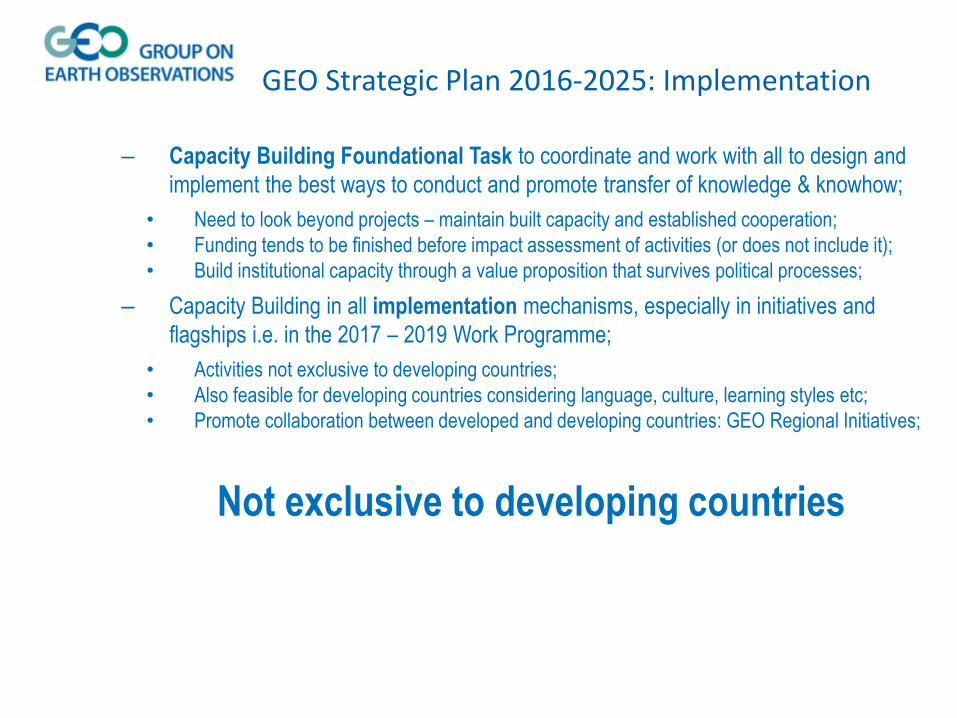
– Capacity Building Foundational Task to coordinate and work with all to design and
implement the best ways to conduct and promote transfer of knowledge & knowhow;
• Need to look beyond projects – maintain built capacity and established cooperation;
• Funding tends to be finished before impact assessment of activities (or does not include it);
• Build institutional capacity through a value proposition that survives political processes;
– Capacity Building in all implementation mechanisms, especially in initiatives and
flagships i.e. in the 2017 – 2019 Work Programme;
• Activities not exclusive to developing countries;
• Also feasible for developing countries considering language, culture, learning styles etc;
• Promote collaboration between developed and developing countries: GEO Regional Initiatives;
GEO Strategic Plan 2016-2025: Implementation
Not exclusive to developing countries

Build on existing efforts
Success stories and good practice

http://www.geocab.org/
By Type By SBA
Organizations Biodiversity
Raw EO Products
Climate
Software Disaster
Success Stories
Ecosystem
Tutorial Water
Marketing Tool Kits
Weather
TrainingMaterial
Energy
Health
Agriculture
Over 1500 resources: any element of interest (human,
organizational, infrastructure, methodological, technical,
promotion, best practice) that can help development of
knowledge in EO field;
Discoverable through GEOSS Portal:
www.geoportal.org

• Software Carpentry
• Google Earth Engine
• Sentinel Data Access & Processing Tools
Outcomes: new skills and also identified
participants for ‘Train the Trainers’ course
AfriGEOSS Training

2030 Agenda for Sustainable Development
GEO Engagement Priorities 2017-2019
Disaster Risk Reduction
Climate Change
Greenhouse Gas Monitoring

The GEO Carbon and GHG Initiative (GEO-C) is a global effort proposed in the framework of GEO to promote interoperability and provide integration across different parts of thesystem, particularly at domain interfaces. The final users, in addition to the scientific community, are countries and decision makers that can benefit from the improvedinformation flow and use it to address climate change policy.
Policy need for research, systematic observations and scientificdata emerges from Paris Agreement. GEO aims to repond to:
National Reporting (Articles 4 and 13) Mitigation: Knowledge of evolution of sinks and sources
(Article 5) Adaptation: Strengthening cooperation (Article 7.6);
Scientific knowledge and systematic observations (Article7.7)
Technology Transfer (Article 10) Capacity Development (Article 11) Global Stocktaking (Article 14)
Open Earth Observation Data for regional climate research, mitigation and
adaptation decision making
Key partners
Towards policy-relevant global carbon cycle observation and analysis
Regional Initiatives
How to access data from GEOSS?
The GEOSS Common Infrastructure (GCI) links more than150 different data catalogs containing more than 400million open EO resources, accessible through an easy-to-use GEOSS Portal. There were more than 4.4 millionenquiries to the GCI in 2016 alone.
www.geoportal.orgBiodiversity and
Ecosystem Sustainability
DisasterResilience Energy and Mineral
Resources Management
Food Security andSustainable Agriculture
Infrastructure and Transport Management
Public HealthSurveillance
Sustainable Urban Development
Water ResourcesManagement
GEO is building Regional Initiatives, such as AfriGEOSS (in Africa), AmeriGEOSS (in theAmericas) and AOGEOSS (in Asia-Oceania) that provide cooperation frameworks at theregional level to support decision-making and regional sustainable development, as well asbuilding institutional and individual capacity by engaging experts, stakeholders and decisionmakers in the region. The regional initiatives have identified data access, processing anddistribution infrastructure capabilities as limiting factors for countries, in particulardeveloping countries, to the uptake of Earth observations in decision-making.
To combat this challenge AfriGEOSS is leveraging the Africa Data Intensive Research Cloud(ADIRC), which aims to provide researchers in African countries with access to highperformance computing (HPC) infrastructures, enabling them to take part in big data scienceprojects and to build Earth observation data processing platforms.
GEO engages providers and users of climate data resourcesthrough targeted workshops and its annual internationalPlenary to ensure a sustained dialogue around the informationneeds of those seeking to integrate climate products andservices into adaptation processes and decisions.
What is GEOSS?
GEOSS is a global infrastructure which builds on national,regional and international observation systems and theirthousands of ground, in situ, air-borne, ship-borne and
space-based instruments.
Why GEOSS?
No one country has the resources needed to collect theEarth observations data required for addressing the majorglobal environmental issues of today. A global system ofsystems approach leverages the existing infrastructuresused for Earth observations.
GEO’s Societal Benefit Areas –
Climate change is across all areas
Priority Area: Climate ChangeThe Group on Earth Observations (GEO)GEO-XIII Plenary (November 2016) agreed on three priorityengagement areas, including “Climate Change – GreenhouseGas Monitoring” to support the implementation of the ParisAgreement. Following the GEO Executive Committee in March2017 the focus will be on both adaptation and mitigation.
Aligned to Paris Agreement
All activities and deliverables of this Initiative will be aligned,improved and adapted to address the climate policy agenda,particularly to contribute to the successful implementation ofthe Paris Agreement
Data integration from regional networks
Comprehensive data
The Initiative is motivated by the long-term vision of a data-driven system to provide comprehensive knowledge on changesin the global carbon cycle and GHG emissions as a result ofhuman activities and global change.GEO-C builds on existing initiatives and networks, supportscontinuity and coherence, facilitates cooperation andinteroperability and fills in gaps.
Up-to-date informationSupport for decision makers with timely policy-relevantinformation to inform mitigation and adaptation actions.
Credits: ICOS
Responding to Paris Agreement
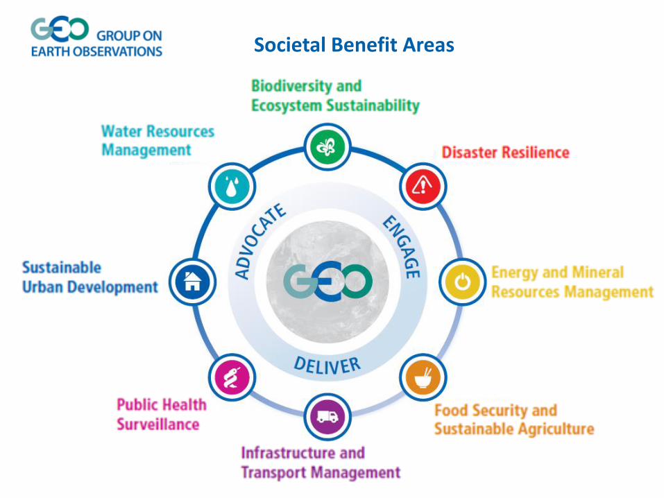
Societal Benefit Areas

GEO Initiatives
GEO-DARMA
Data Access for Risk
management
GSNL
Geohazard Supersites and
Natural Laboratories
GWIS
Global Wildfire
Information System
GDIS
Global Drought
Information System
Community Activities
Chinese tsunami
mitigation system
Earth Observations for
Disaster Risk Management
EO for Geohazards,
Land Degradation and
Environmental Monitoring
Global Flood Risk
Monitoring
GloFAS
Global Flood
Awareness System
Space & Security
Disaster Resilience

Disaster-related Data for Sustainable DevelopmentSendai Framework Data Readiness Review 2017Global Summary Report, Section 2.2http://www.preventionweb.net/files/53080_entrybgpaperglobalsummaryreportdisa.pdf
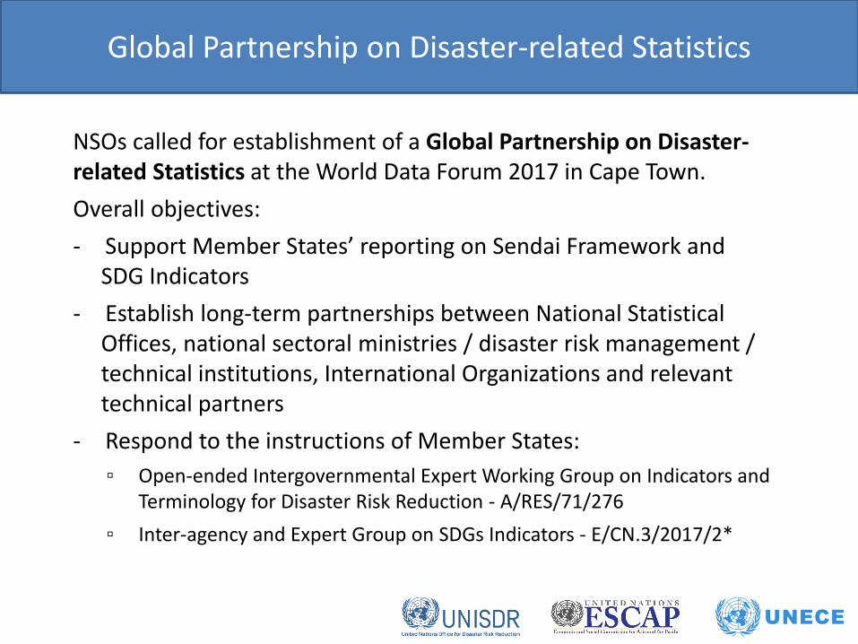
NSOs called for establishment of a Global Partnership on Disaster-related Statistics at the World Data Forum 2017 in Cape Town.
Overall objectives:
- Support Member States’ reporting on Sendai Framework and SDG Indicators
- Establish long-term partnerships between National Statistical Offices, national sectoral ministries / disaster risk management / technical institutions, International Organizations and relevant technical partners
- Respond to the instructions of Member States:
▫ Open-ended Intergovernmental Expert Working Group on Indicators and Terminology for Disaster Risk Reduction - A/RES/71/276
▫ Inter-agency and Expert Group on SDGs Indicators - E/CN.3/2017/2*
Global Partnership on Disaster-related Statistics
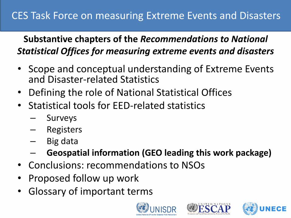
Substantive chapters of the Recommendations to National Statistical Offices for measuring extreme events and disasters
• Scope and conceptual understanding of Extreme Events and Disaster-related Statistics
• Defining the role of National Statistical Offices• Statistical tools for EED-related statistics
– Surveys– Registers– Big data– Geospatial information (GEO leading this work package)
• Conclusions: recommendations to NSOs• Proposed follow up work• Glossary of important terms
CES Task Force on measuring Extreme Events and Disasters

UN-GGIM Working Group on Geospatial Information and Services for Disastershttp://ggim.un.org/UN_GGIM_wg5.html
Kunming Forum on UN-GGIM "Cities of the Future: Smart. Resilient and Sustainable” May 2017Strategic Framework on Geospatial Information and Services for Disasters. http://ggim.un.org/Kunming_Forum.html
UN-GGIM International Forum on Geospatial Information and Services for Disasters September 2016http://ggim.un.org/Barbados%20Disaster%20Forum.html
Chengdu Forum on UN-GGIM "Development & Applications in Urban Hazard Mapping” October 2013Disaster managers and geospatial experts. http://ggim.un.org/Chengdu%20Forum.html

The 2030 Plan for Global
Action - Article 76:
“We will promote transparent
and accountable scaling-up
of appropriate public-private
cooperation to exploit the
contribution to be made by a
wide range of data, including
Earth observation and geo-
spatial information, while
ensuring national ownership
in supporting and tracking
progress.”
Direct measures of some
Indicators and indirect
support to others.
Contribute to progress on the
Targets, which will show up in
the Indicators.
EO4SDGs

Work closely with UN-GGIM.
GEO represented on Inter-Agency Expert Group (IAEG) of the UN Statistics Division in the Working Group on Geospatial Information (WGGI).
GEO is the Earth Observation Anchor Partner to the Global Partnership for Sustainable Development Data (GPSDD).
GEO support for SDGs

GEO Biodiversity Observation
Network (GEO BON)
GEO Global Agriculture
Monitoring (GEOGLAM)
The Global Forest
Observations Initiative (GFOI)
Global Observation System
for Mercury (GOS4M)

GEO GLAM – leveraging Earth observations for a food-secure world
Crop monitor for
Early WarningCrop monitor for AMIS


GEO is instrumental in integrating use of Earth observation data into the methodology of measuring and achieving Sustainable Development Goal Indicators.
This brochure gives graphic illustration of the types of EO data sets and images available which means decision-makers can not only use data to identify the status they need to report, they can visualize the solution, too.
EO case studies: Agenda 2030
https://www.earthobservations.org/documents/publications/201703_geo_eo_for_2030_agenda.pdf

Decision tree on usage of EO data for National Statistical Organisations
https://www.earthobservations.org/documents/publications/201703_geo_eo_for_2030_agenda.pdf P30

USE OF SATELLITE IMAGES TO CALCULATE STATISTICS ON LAND COVER AND LAND USE: PILOT PROJECT REPORT FROM DANE (National Statistics Office of Colombia)
Integration of EO & statistical data to report on SDGs [Indicator 68: Ratio of land consumption & population growth rates]


GEOSS Common Infrastructure (GCI)

Your Cases!
Build the socioeconomic business case

GEO Observations Blog: Geoscience Australia
WWW.EARTHOBSERVATIONS.ORG/BLOG


earthobservations.org/geoweek2017
Mark your calendar now!

Connect and collaborate:
@GEOSEC2025 and @steven_ramage
Group on Earth Observations
Group on Earth Observations
earthobservations.org and geoportal.org
Steven Ramage, GEO Secretariat

Contribution to open standards policy
and national mapping guidance
https://www.ordnancesurvey.co.uk/docs/policies/ordna
nce-survey-geospatial-standards-policy.pdf
http://ggim.un.org/docs/meetings/GGIM4/National%20M
apping%20Authority%20Perspective%20-
%20International%20Geospatial%20Standards.pdf