callahanminehc soil pb final - cdc
TRANSCRIPT

Health Consultation CALLAHAN MINE SUPERFUND SITE
BROOKSVILLE (CAPE ROSIER), HANCOCK COUNTY, MAINE
EPA FACILITY ID: MED980524128
AUGUST 15, 2008
U.S. DEPARTMENT OF HEALTH AND HUMAN SERVICES Public Health Service
Agency for Toxic Substances and Disease Registry Division of Health Assessment and Consultation
Atlanta, Georgia 30333

Health Consultation: A Note of Explanation
An ATSDR health consultation is a verbal or written response from ATSDR to a specific request for information about health risks related to a specific site, a chemical release, or the presence of hazardous material. In order to prevent or mitigate exposures, a consultation may lead to specific actions, such as restricting use of or replacing water supplies; intensifying environmental sampling; restricting site access; or removing the contaminated material.
In addition, consultations may recommend additional public health actions, such as conducting health surveillance activities to evaluate exposure or trends in adverse health outcomes; conducting biological indicators of exposure studies to assess exposure; and providing health education for health care providers and community members. This concludes the health consultation process for this site, unless additional information is obtained by ATSDR which, in the Agency’s opinion, indicates a need to revise or append the conclusions previously issued.
You May Contact ATSDR TOLL FREE at 1-800-CDC-INFO
or Visit our Home Page at: http://www.atsdr.cdc.gov
HEALTH CONSULTATION
CALLAHAN MINE SUPERFUND SITE
BROOKSVILLE (CAPE ROSIER), HANCOCK COUNTY, MAINE
EPA FACILITY ID: MED980524128
Prepared By:
U.S. Department of Health and Human Services Agency for Toxic Substances and Disease Registry

Callahan Mine Superfund Site Review of lead levels in residential soils
Table of Contents
1.0 Statement of Issues ................................................................................................. 1 2.0 Background............................................................................................................. 1 2.1 Site description................................................................................................ 1 2.2 Superfund activities at the Site ........................................................................ 2 2.3 Lead ................................................................................................................. 2 2.4 IEUBK model .................................................................................................. 3 3.0 Summary of relevant data ....................................................................................... 4 3.1 Lead in soil data............................................................................................... 4 3.2 IEUBK modeling results.................................................................................. 5 4.0 Discussion............................................................................................................... 5 4.1 Uncertainties and limitations in the soil data................................................... 7 4.2 Uncertainties and limitations in the IEUBK modeling.................................... 7 5.0 Child Health Considerations ................................................................................... 8 6.0 Conclusions............................................................................................................. 9 7.0 Recommendations................................................................................................. 10 8.0 Authors and reviewers .......................................................................................... 12 9.0 References............................................................................................................. 13
Figures and Tables ............................................................................................................ 14 Figure 1. Callahan Mine Superfund Site location ....................................................... 15 Figure 2. Areas of interest within and around the Site.................................................. 16 Figure 3. Soil sampling locations at the four residential lots........................................ 17 Table 1. Summary of soil data for selected areas associated with the Callahan Mine
Superfund Site ............................................................................................... 18 Table 2. Lead exposure point concentrations (EPCs) used in the Integrated Exposure
Uptake Biokinetic (IEUBK) model ............................................................... 19 Table 3. Summary of Integrated Exposure Uptake Biokinetic (IEUBK) blood lead modeling results............................................................................................. 20 Appendix A ... ................................................................................................................... 21
i

Callahan Mine Superfund Site Review of lead levels in residential soils
1.0 Statement of Issues The Environmental Protection Agency (EPA) requested that the Agency for Toxic Substances and Disease Registry (ATSDR) review available data for the current exposure pathway for lead in soil at four private residential properties near the Callahan Mine Superfund Site (Site) to determine if immediate soil removal is necessary. This EPA request is being managed by ATSDR under our “Strike” process, which means that it is a rapid-response, focused effort that does not include comprehensive review of Site contaminants and exposure pathways. The primary sources of information for this focused health consultation are the data and analyses pertaining to residential soil that are contained in the Draft Human Health Risk Assessment (HHRA) [MACTEC 2008], the EPA Superfund website for the Site, and information obtained from EPA via personal communication.
2.0 Background The following paragraphs provide a summary of the salient characteristics of the Site, Superfund activities at the Site, and background information about lead and EPA’s Integrated Exposure Uptake Biokinetic (IEUBK) model for lead in children.
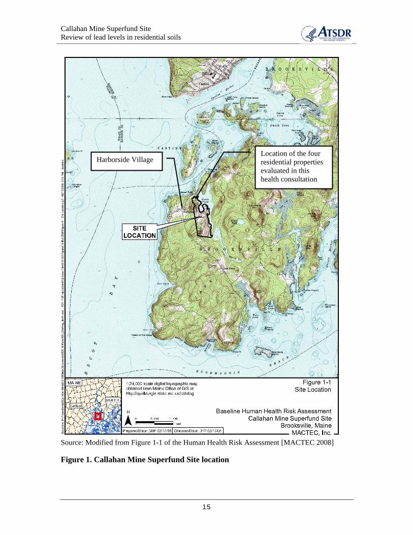
2.1 Site description The Site comprises 150 acres on the coast of Maine, 30 miles south of Bangor (Figure 1). It is situated on the Cape Rosier peninsula in Penobscot Bay, near the village of Harborside.
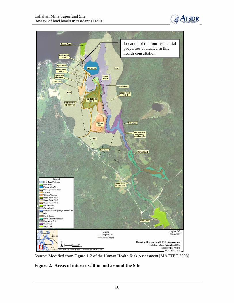
The Callahan Mining Corporation operated a zinc and copper mine at the Site during 1881–1887 and 1968–1972. Open-pit mining operations took place adjacent to and beneath Goose Pond (Goose Pond was dammed and drained during mining operations). Currently, the Site is divided into several study areas. The Source Area consists of several waste rock piles, a tailings pile, ore pad, and former mill operations areas (Figure 2). In general, the Source Area is sparsely vegetated. Sampling has confirmed that soil and rock in the Source Area contain elevated levels of several metals, including arsenic, cadmium, copper, lead, and zinc. The following excerpt from the HHRA provides an overview of the other Site areas depicted in Figure 2.
“The Source Area is surrounded by a densely wooded forest where wind deposition of dust during mining operations occurred in a ‘halo’ that extends up to 200 feet from the edge of the source areas. This area is referred to as the Halo Area. There are three surface water bodies surrounding the rock piles and former mill areas. These include Goose Cove, which is part of Penobscot Bay; Goose Pond, which is a tidal pond that is connected through a narrow raceway to Goose Cove; and Marsh Creek, which is a freshwater stream that discharges to both Goose Pond through an irregularly flooded area (termed the Goose Pond Irregularly Flooded Area) and to Weir Cove.” [MACTEC 2008]
Much of the area surrounding the Site is open, forested land. However, four residential properties are located on Old Mine Road, on the west side of Goose Pond, immediately adjacent to the former mining pit. Two children, ages 10 and 12, are reportedly living at
1

Callahan Mine Superfund Site Review of lead levels in residential soils
one of the four homes for at least part of the year.1 Several other residential properties are situated along Goose Falls Road within ¼ mile of the Site. The Site is accessed by trespassers and used for recreational purposes, including all terrain vehicle (ATV) riding, boating, swimming, and fishing [MACTEC 2008, ATSDR 2003]. According to the HHRA, the State closed the shell fishing beds in Goose Pond and Goose Cove to commercial operations [MACTEC 2008]. In 2003, ATSDR representatives noted that fish and shellfish were collected on and near the Site and residents reported that shellfish were eaten from Goose Pond despite the shellfish advisory in place at that time [ATSDR 2003].
2.2 Superfund activities at the Site In September of 2002, the Site was added to the National Priorities List (NPL). EPA conducted environmental sampling at the Site in 2004. Additional sampling events in support of the remedial investigation and feasibility study were conducted in 2005 and 2007. Environmental sampling included soil, sediment, surface water, groundwater seeps, and biota from the Site and surrounding areas. A Draft Human Health Risk Assessment (HHRA) was completed and published in March 2008. Current projections indicate the remedial investigation and feasibility study will be completed in 2009 and a plan for the Site cleanup will also be released during 2009 (EPA website). According to EPA, field activities for the actual Site cleanup probably will begin 3 to 5 years after the Site cleanup plan is released.2
The State of Maine became the lead agency for implementation of the remedial investigation and feasibility study in 2005. The Maine Department of Transportation manages the project and the Maine Department of Environmental Protection provides regulatory oversight. EPA has primary oversight responsibilities for the project.
2.3 Lead Lead is a naturally occurring bluish-gray metal found in small amounts in the earth's crust. Lead can be found in all parts of our environment. Much of it comes from human activities including burning fossil fuels, mining, and manufacturing [ATSDR 2007].
Lead can affect almost every organ and system in the body, although the main target for lead toxicity is the nervous system. Children are more vulnerable to lead poisoning than adults. A child who swallows large amounts of lead may develop blood anemia, severe stomach-ache, muscle weakness, and brain damage. Unborn children can be exposed to lead through their mothers. Harmful health effects include premature births, smaller babies, decreased mental ability in the infant, learning difficulties, and reduced growth in young children [ATSDR 2007].
Previously, the Centers for Disease Control and Prevention (CDC) responded to the accumulated evidence of adverse effects associated with lead exposures by lowering the blood lead level (BLL) of concern from 60 micrograms of lead per deciliter of blood (μg/dL) to 25 μg/dL. In 1991, CDC recommended lowering the level for individual
1 Ed Hathaway, EPA Region 1, personal communication, June 16, 2008. 2 Ed Hathaway, EPA Region 1, personal communication, June 05, 2008.
2

Callahan Mine Superfund Site Review of lead levels in residential soils
intervention to 15 μg/dL and implementing community primary lead poisoning prevention activities in areas where many children have BLLs greater than 10 μg/dL. However, this level, which was originally intended to trigger community prevention activities, has been misinterpreted frequently as a definitive toxicologic threshold. Although there is evidence of adverse health effects in children with blood lead levels below 10 μg/dL, CDC has not changed its level of concern, which remains at levels greater than 10 μg/dL [CDC 2005].
Because there is no clear threshold for some of the more sensitive health effects, no guidelines for a safe dose of lead intake have been established. EPA has no reference dose (RfD) and ATSDR has no minimal risk revel (MRL) to serve as a safe oral dose below which adverse health effects are unlikely to occur. Therefore, the usual approach of estimating exposure to an environmental contaminant and then comparing this dose to a health guideline (such as an RfD or MRL) cannot be used. Instead, exposure to lead is evaluated by using a biological model that predicts a blood lead concentration that would result from exposure to environmental lead contamination. The most widely used model for this purpose is EPA’s Integrated Exposure Uptake Biokinetic (IEUBK) Model for Lead in Children.
2.4 IEUBK model EPA’s IEUBK model is designed to integrate exposure from lead in air, water, soil, dust, diet, paint, and other sources with pharmacokinetic modeling to predict blood lead concentrations in children 6 months to 7 years of age. The four main components of the current IEUBK model are: (1) an exposure model that relates environmental lead concentrations to age-dependent intake of lead into the gastrointestinal tract; (2) an absorption model that relates lead intake into the gastrointestinal tract and lead uptake into the blood; (3) a biokinetic model that relates lead uptake in the blood to the concentrations of lead in several organ and tissue compartments; and (4) a model for uncertainty in exposure and for population variability in absorption and biokinetics [EPA 1994].
The IEUBK model can be a tool for the determination of site-specific cleanup levels. It also can be used as a predictive tool for estimating BLLs for children exposed to lead in the environment [EPA 1994]. EPA’s stated goal is to “… limit exposure to soil lead levels such that a typical (or hypothetical) child or group of similarly exposed children would have an estimated risk of no more than 5% of exceeding a blood lead level of 10 µg/dL” [EPA 1998].
The IEUBK model contains a number of input parameters that can be adjusted when estimating a child’s BLL. The reliability of the results obtained using the model is very dependent on the input values specified by the user. Using default values for all parameters in the IEUBK model yields a soil lead level of about 400 milligrams per kilogram (mg/kg), which EPA recommends as a screening level for lead in soil at residential properties [EPA 1998].
3
Callahan Mine Superfund Site Review of lead levels in residential soils
3.0 Summary of relevant data The Site data and analyses contained in the HHRA [MACTEC 2008] are the primary sources of information for this focused health consultation. ATSDR relied on data reported in the HHRA. ATSDR did not independently review the sampling plans, the raw sample data, or the quality assurance/quality control information for sample collection and analysis, or the underlying regulatory guidance cited in HHRA. ATSDR acknowledges that our analyses, conclusions, and recommendations are valid only if the information we received to evaluate are complete and reliable.
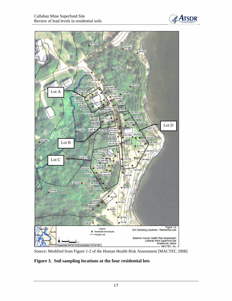
3.1 Lead in soil data Soil sample locations for the four residential properties are depicted in Figure 3. The smallest property, Lot B, is estimated to be less than 1/4-acre. The largest property, Lot D, is estimated to be approximately 2/3-acre. Samples were collected from surface soil, typically from 0 to 6 inches below ground surface, although some variation was noted in individual samples. Lead in soil levels across these four properties range from 16 to 1,500 mg/kg. The average (arithmetic mean) and maximum lead concentrations, in mg/kg, for each property are as follows:
• Lot A: 511 (average) 1,100 (maximum) • Lot B: 168 (average) 290 (maximum) • Lot C: 403 (average) 1,500 (maximum) • Lot D: 455 (average) 1,400 (maximum)
Three of the four residential properties have average lead in soil levels above the applicable screening values of 400 mg/kg (EPA guidance value) and 375 mg/kg (Maine Residential Remedial Action Goal). A summary of the sample results available for each property is also included in Table 1.
Many of the residential soil samples were analyzed onsite using x-ray fluorescence (XRF) methods. Some samples were sent to a laboratory for analysis. For two properties, Lots B and D, only XRF sample results are available. For the other two properties, Lots A and C, both laboratory and XRF data are available.
Onsite XRF was used to analyze soil and sediment samples for selected metals at other areas of the Site, including the Source Area and the Halo Area. Ten percent of these samples were also submitted for laboratory analysis. The correlation between the XRF and laboratory results was reportedly good (regression analyses r2 values greater than 0.9), and it was noted that the XRF results tended to be higher than the laboratory results [MACTEC 2008].
For context, several notes on lead levels in soil and other environmental media are appropriate:
• The average concentration of lead in soil within the Source Area is 774 mg/kg; the maximum detected concentration is 2,300 mg/kg (Table 1).
• The average concentration of lead in soil within the Halo Area is 272 mg/kg; the maximum detected concentration is 1,460 mg/kg (Table 1).
4
Callahan Mine Superfund Site Review of lead levels in residential soils
• Lead was selected as a chemical of potential concern in various areas of soil, sediment, surface water, biota, and groundwater in and around the Site.
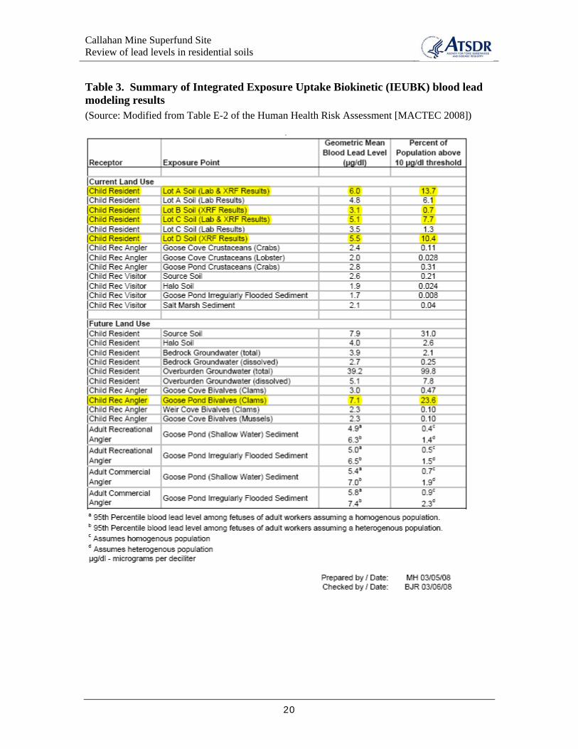
3.2 IEUBK modeling results A summary of the exposure point concentrations (EPCs) calculated for lead in various site-related media are presented in Table 2. Note that these EPC values, which are subsequently used for the blood lead modeling, correspond to the arithmetic mean value of lead in soil for each property.
IEUBK modeling results are included in Table 3 for a current land use scenario and a future land use scenario. For the residential soil pathway, the IEUBK model was run using the site-specific soil EPC value selected for each residential property (Table 2) and all other parameters were set to the standard default values. For the other pathways, the model was run with the EPC value for the medium of interest, the soil level set as the site-specific background level, and most other parameter values set to the default values. For the biota pathway, it was assumed that very young children were unlikely to consume shellfish, so the IEUBK model was adjusted to include uptake of lead from ingestion of biota for only ages 4 through 7. Additionally, the following adjustment was used for nonresidential exposure to soil and sediment (that is, the “Child Rec Visitor” scenarios listed in Table 3):
“…the soil and sediment EPCs for lead were adjusted to reflect the recreational exposure frequency for soil and sediment, by multiplying the EPCs by the ratio of soil or sediment exposure frequency (e.g., 52 days per year for soil) to model default exposure frequency (365 days per year). The adjusted EPCs were used in the model. In addition, the model was set such that all ingestion of lead in soil or sediment ingestion occurred from those media, and not dust generated from those media.” [MACTEC 2008]
Under the current land use scenario, the blood lead modeling completed for lead in soil at each of the four residential properties predicted geometric mean BLLs below the recommended 10 µg/dL threshold. However, at three of the four locations, the model indicated an elevated probability of exceeding the 10 µg/dL threshold. EPA recommends that the probability of exceedance should be below 5%; the predicted probability of exceedance for Lots A, C, and D was 13.7%, 7.7%, and 10.4% , respectively. In other words, at Lot A, the model predicted that a child (or a similarly exposed group of children) would have a 13.7% probability of exceeding a BLL of 10 µg/dL.
Within the current land use scenario, the blood lead modeling for all other line item exposure pathways predicted BLLs below the recommended threshold of 10 µg/dL, with probability of exceedance values below 1%. Within the future land use scenario, the blood lead modeling for a child consuming clams from Goose Pond predicts a BLL of 7.1 µg/dL with a probability of 23.6% that the BLL will exceed the 10 µg/dL threshold.
4.0 Discussion Residents of the four properties located along Old Mine Road are exposed to lead from the Site in many different ways, including from lead-contaminated surface soil in their yards. Lead levels in soil are elevated (above measured background levels for the area) at
5

Callahan Mine Superfund Site Review of lead levels in residential soils
each of the four residential properties. Additionally, elevated lead levels occur in other environmental media in and around the Site, including soil, sediment, surface water, groundwater seeps, and biota (fish, lobster, and clams).
The information contained in the HHRA focuses on assessing risk to Site-related lead contamination. However, as outlined in EPA guidance, the contribution of multiple environmental sources of lead to overall lead exposure should be assessed [EPA 1998]. The homes in this area are reportedly older and may have been constructed before 1978. These homes should be assessed for interior and exterior lead-based paint as well as lead plumbing components.
EPA, CDC, and ATSDR agree that 10 µg/dL is the threshold level of concern for BLLs in children. EPA’s guidance for interpreting IEUBK modeling results is to “… limit exposure to soil lead levels such that a typical (or hypothetical) child or group of similarly exposed children would have an estimated risk of no more than 5% of exceeding a blood lead level of 10 µg/dL” [EPA 1998]. EPA supplies additional guidance for interpreting soil sample results and prioritizing response actions at residential lead sites in their Superfund Lead-Contaminated Residential Sites Handbook [EPA 2003a]. Within this guidance, EPA defines the following tiers for categorizing residential lead sites (abbreviations used: ppm, parts per million; TCRA, time-critical removal action; NTCRA, non time-critical removal action):
• “Tier 1 properties have both sensitive populations (children up to 7 years old or pregnant women) and soil concentrations in the surface soils (0–1" depth) at or above 1,200 ppm (EPA, 1997b, 1997c)3. Also, Tier 1 sites can be identified based upon a demonstration of children’s blood lead levels at or above 10 μg/dL. Generally, TCRAs would be taken at Tier 1 properties.
• Tier 2 properties have either sensitive populations and soil lead concentrations in surface soils between 400 ppm and 1,200 ppm, or no sensitive populations and surface soil lead concentrations above 1,200 ppm, but not both. Tier 2 properties can be addressed through TCRAs, or non-time-critical removal actions (NTCRAs), or long-term remedial actions.
• Tier 3 properties have surface soil concentrations below 1,200 ppm, but above 400 ppm, and no sensitive populations present. Tier 3 sites would typically be addressed through long-term remedial actions or NTCRAs.
Tier 1 should be the highest priority for immediate action and Tier 3 should be the lowest priority for immediate action. Residential properties can move into a different tier if conditions change (e.g., small children or pregnant women move into a house).” [EPA 2003a]
Based on the documented soil concentrations in the HHRA and the assumption that no sensitive subpopulations (children under 7 years old and pregnant women) are living
3 U.S. Environmental Protection Agency (EPA). 1997b. Lead Site Response Decisions: Formation of the Lead Sites Consultation Group. Memo from Steve Luftig dated May 29, 1997. U.S. Environmental Protection Agency (EPA). 1997c. OSWER Directive 9200.1-18FS: Consolidated Guide to Consultation Procedures for Superfund Response Decisions. EPA/540-F-97-009. May 1997.
6

Callahan Mine Superfund Site Review of lead levels in residential soils
there, the residential properties along Old Mine Road would be categorized as Tier 3. For Tier 3 properties, soil cleanup can occur through non time-critical removal or long-term remedial action4.
The following paragraphs present some of the uncertainties, limitations, and data gaps in the information that ATSDR reviewed.
4.1 Uncertainties and limitations in the soil data ATSDR noted several items pertaining to the residential soil samples that may need to be addressed:
• Clarification is needed for how individual soil samples were associated with Lots C and D. Sample SS-7269H is located on Lot D in Figure 1-8, but it is associated with Lot C in Table A-7. Three samples (SS-7253H, SS-7259H, SS-7263H) were associated with Lot D in Table A-8, but they appear to be outside the property boundary for Lot D. If these three samples are excluded from Lot D, the average (and therefore EPC value) for lead in Lot D increases by 43 mg/kg (from 455 mg/kg to 498 mg/kg).
• Sampling at the four residential properties did not follow the EPA guidance for residential lead in soil [EPA2003a]. This guidance recommends collecting composite samples in quadrants determined by the size of the yard. Additionally, special consideration should be given to children’s play areas, gardens, and drip zones (of the house), among others. The sampling results used for the HHRA appear to be from grab samples and no information is available to indicate if play areas, gardens, drip zones, or other such areas were specifically sampled as recommended in EPA guidance.
4.2 Uncertainties and limitations in the IEUBK modeling Using only the recommended default parameter values for the IEUBK model can produce results that overpredict actual BLLs [von Lindern et al. 2003]. One limitation of the IEUBK model for this Site is the inability to decrease the exposure frequency. The default value for exposure frequency is 365 days per year. For this area of coastal Maine, the ground surface (and lead-contaminated soil) is covered with snow for part of the year. The annual average snowfall for Acadia National Park, approximately 30 miles east of the Site, is 60 inches per year. Snow cover would limit the exposure of residents to lead-contaminated soil.
Another conservative aspect of the IEUBK model is its inherent focus on children under age 7. Given this focus, model results will be protective of older children and adults and will tend to overpredict BLLs for these groups.
ATSDR considers the following factors in the IEUBK analysis to be less than conservative, and in most cases would result in lower predicted BLLs:
4 EPA states that “… removal actions are subject to limits on time (12 months) and money ($2,000,0000)” while “remedial actions are typically long-term responses …” [EPA 2003a].
7
Callahan Mine Superfund Site Review of lead levels in residential soils
• The EPC values for the IEUBK model were selected as the arithmetic mean of all samples collected for a given area. The measured soil concentrations for three of the residential areas span 2 orders of magnitude. The arithmetic mean may not be representative for such a large range.
• The IEUBK modeling focused on scenarios for individual exposure media independently and did not address the potential for cumulative effects across multiple media. For example, the results for a child resident exposure to soil in Lot A do not include concurrent exposure to crabs from Goose Cove (via consumption). Likewise, the results for consumption of crabs from Goose Cove do not include concurrent exposure to elevated lead levels measured in residential soil. Instead, for the latter scenario, a background lead level was assumed for residential soil [MACTEC 2008]. While this approach is helpful for identifying the independent, relative risk of each of these exposure pathways, it does not provide an estimate of overall risk for an individual from multi-media exposures to lead.
One scenario of concern for the Site involves a child living at Lots A, C, or D who consumes clams from Goose Pond. Exposure to lead from consumption of Goose Pond clams was only evaluated for the future land use scenario in the HHRA (labeled “Child Rec Angler” in the future land use column of Table 3). This is presumably because the State closed the shellfish beds at Goose Pond. However, in 2003, ATSDR representatives noted that fish and shellfish were collected on and near the Site and residents reported that shellfish were eaten from Goose Pond despite the shellfish advisory [ATSDR 2003].
• The adjustment used within the IEUBK model to account for a lower exposure frequency for non-residential exposure to soil and sediment (used for the Source Area soil, Halo Area soil, Goose Pond Irregularly Flooded Area sediment, and Salt Marsh sediment) does not appear to follow EPA guidance for assessing intermittent or variable exposures at lead sites [EPA 2003b]. The approach used was to multiply the EPC by the ratio of soil or sediment frequency (selected as 52 days per year for soil, for example) to the default exposure frequency in the model (365 days per year). These adjusted EPCs were used in the IEUBK model to predict BLLs resulting from exposure to each medium. Additionally, the model parameters were adjusted to include only ingestion of soil or sediment and not dust generated from disturbing the soil or sediment. ATSDR suggests verifying this approach with the EPA Lead Technical Review Workgroup (www.epa.gov/superfund/lead/trw.htm).
5.0 Child Health Considerations ATSDR recognizes the unique vulnerabilities of children from exposure to hazardous substances in their environment. Children are at greater risk than are adults from certain kinds of exposures to hazardous substances because they often have greater exposure than do adults. For instance, children frequently play outdoors and are more likely to come in contact with soil than are adults. Children are more likely to get dirt on their hands, and are more likely to swallow some of that dirt if they do not wash their hands
8
Callahan Mine Superfund Site Review of lead levels in residential soils
properly before eating. Children are also smaller than adults, resulting in higher doses of chemical exposure per body weight. Most important, children depend completely on adults for risk identification and management decisions, housing decisions, and access to medical care. Consequently, whenever soil is a pathway of concern—as it is for the residential properties along Old Mine Road—children will have greater exposure to substances in the soil than will adults. Children with soil pica behavior are of particular concern because they could possibly have significant exposures to lead-contaminated soil.
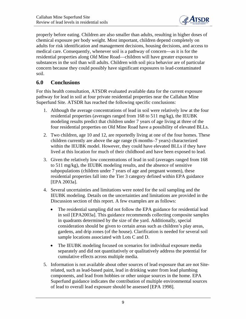
6.0 Conclusions For this health consultation, ATSDR evaluated available data for the current exposure pathway for lead in soil at four private residential properties near the Callahan Mine Superfund Site. ATSDR has reached the following specific conclusions:
1. Although the average concentrations of lead in soil were relatively low at the four residential properties (averages ranged from 168 to 511 mg/kg), the IEUBK modeling results predict that children under 7 years of age living at three of the four residential properties on Old Mine Road have a possibility of elevated BLLs.
2. Two children, age 10 and 12, are reportedly living at one of the four homes. These children currently are above the age range (6 months–7 years) characterized within the IEUBK model. However, they could have elevated BLLs if they have lived at this location for much of their childhood and have been exposed to lead.
3. Given the relatively low concentrations of lead in soil (averages ranged from 168 to 511 mg/kg), the IEUBK modeling results, and the absence of sensitive subpopulations (children under 7 years of age and pregnant women), these residential properties fall into the Tier 3 category defined within EPA guidance [EPA 2003a].
4. Several uncertainties and limitations were noted for the soil sampling and the IEUBK modeling. Details on the uncertainties and limitations are provided in the Discussion section of this report. A few examples are as follows:
• The residential sampling did not follow the EPA guidance for residential lead in soil [EPA2003a]. This guidance recommends collecting composite samples in quadrants determined by the size of the yard. Additionally, special consideration should be given to certain areas such as children’s play areas, gardens, and drip zones (of the house). Clarification is needed for several soil sample locations associated with Lots C and D.
• The IEUBK modeling focused on scenarios for individual exposure media separately and did not quantitatively or qualitatively address the potential for cumulative effects across multiple media.
5. Information is not available about other sources of lead exposure that are not Site-related, such as lead-based paint, lead in drinking water from lead plumbing components, and lead from hobbies or other unique sources in the home. EPA Superfund guidance indicates the contribution of multiple environmental sources of lead to overall lead exposure should be assessed [EPA 1998].
9

Callahan Mine Superfund Site Review of lead levels in residential soils
7.0 Recommendations ATSDR understands that a level of flexibility is needed to best respond to different site conditions, communities, and uncertainties at lead-contaminated residential sites. The choice between various cleanup alternatives is ultimately a risk management decision. ATSDR acknowledges that many other considerations not evaluated in this health consultation must be addressed by risk managers in the final selection of a cleanup alternative. With this in mind, ATSDR recommends the following:
1. The residents, particularly the children, living in homes along Old Mine Road should be offered blood lead screening. This would be a prudent public health action, given the multiple pathways for exposure to lead in and around the Site, the IEUBK modeling results for residential soil, and the uncertainties and data gaps about sources of lead exposure in addition to residential soil. Blood lead monitoring should continue for these residents until residential soil cleanup is completed.
2. Based solely on current IEUBK modeling results and uncertainties noted in this health consultation, exposure to lead in residential soil should be reduced at three of the four properties along Old Mine Road. ATSDR would support clean-up actions such as excavation and removal of lead-contaminated residential soil as a permanent measure that would be protective of human health in the long-term.
As long as there are no sensitive populations (children under 7 years of age and pregnant women) living at the residential properties along Old Mine Road, ATSDR finds that in this case a time-critical removal of lead-contaminated soil at Lots A, C, and D does not need to occur. However, if these conditions change (that is, children under 7 or pregnant women are living at these homes), the need for time-critical residential soil cleanup may need to be re-evaluated. This is consistent with EPA guidance for Tier 3 residential lead sites [EPA 2003].
It is ATSDR’s understanding that Site-wide cleanup will begin in 4–6 years, during 2012–2014. If EPA schedules residential soil cleanup during Site-wide cleanup, periodic (at least annual) follow up with residents along Old Mine Road should be initiated to ensure that conditions in the household do not change before residential soil cleanup is completed.
3. Environmental assessments should be conducted for the four residential properties on Old Mine Road to confirm the date of construction and the presence and extent of lead-based paint and/or lead components in the water distribution system. If these homes were built before 1978, it is likely that lead-based paint was used. These other sources of lead in the home could contribute significantly to the overall lead exposure for individuals living in these homes.
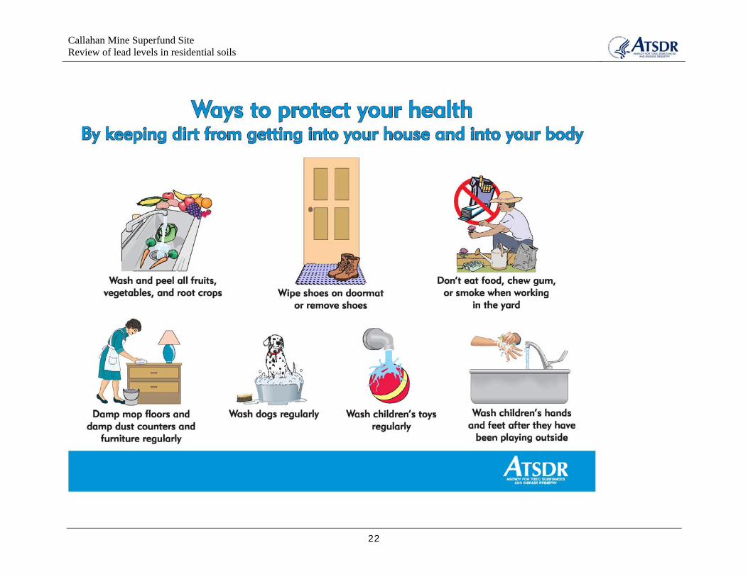
4. Community outreach and education should be initiated to promote compliance with Site institutional controls (such as the fish and shellfish advisories for the area) and inform residents (particularly those residing along Old Mine Road or within the Halo area) about public health actions they can take to reduce their exposures to lead in residential soil. Such actions include washing and peeling fruits and vegetables from the garden, washing their hands after working in the
10
Callahan Mine Superfund Site Review of lead levels in residential soils
yard, and wiping their feet or removing their shoes before entering the home (see example graphic in Appendix B). Additionally, community outreach and education should provide information about lead exposure and health effects, provide information about health monitoring (blood lead testing) that is available locally, and promote environmental assessments in area homes to identify all sources and pathways for lead exposure, including lead-based paint and lead plumbing.
5. Cleanup goals for lead in residential soil should be based on IEUBK modeling that includes exposure to residential soil as well as exposure to other Site-related media as appropriate. This approach is consistent with EPA Superfund guidance [EPA 1998].
11
Callahan Mine Superfund Site Review of lead levels in residential soils
8.0 Authors and reviewers
Prepared by Barbara Anderson, PE, MSEnvE Environmental Health Scientist Exposure Investigation and Site Assessment Branch Division of Health Assessment and Consultation
Reviewed by Tarah Somers, RN, MSN/MPH Lieutenant Commander, U.S. Public Health Service Division of Regional Operations, Region I
Danielle M. Langmann, MS Environmental Health Scientist, Strike Team Coordinator Exposure Investigation and Site Assessment Branch Division of Health Assessment and Consultation
Don Joe, PE Acting Deputy Branch Chief Exposure Investigation and Site Assessment Branch Division of Health Assessment and Consultation
Daphne Moffett, PhD Commander, U.S. Public Health Service Associate Director of Science Division of Health Assessment and Consultation
12

Callahan Mine Superfund Site Review of lead levels in residential soils
9.0 References
[ATSDR] Agency for Toxic Substances and Disease Registry. 2003. Public health assessment, Callahan Mining Corporation, Brooksville (Cape Rosier), Hancock County, Maine. Atlanta: US Department of Health and Human Services. Available at: www.atsdr.cdc.gov/HAC/pha/callahan2/cal_toc.html
[ATSDR] Agency for Toxic Substances and Disease Registry. 2007. Toxicological profile for lead (update). Atlanta: US Department of Health and Human Services.
[CDC] Centers for Disease Control and Prevention. 2005. Preventing lead poisoning in young children: a statement by the Centers for Disease Control and Prevention. Atlanta: US Department of Health and Human Services.
[EPA] US Environmental Protection Agency. 1994. Guidance manual for the integrated exposure uptake biokinetic model for lead in children. NTIS #PB93-963510, EPA 9285.7-15-1. Washington, DC: Office of Solid Waste and Emergency Response.
[EPA] US Environmental Protection Agency. 1998. Clarification to the 1994 revised interim soil lead (Pb) guidance for CERCLA sites and RCRA corrective action facilities. OSWER Directive No. 9200.4–27P, Document no. EPA/540/F-98/030, PB98-963244. Washington, DC: Office of Solid Waste and Emergency Response.
[EPA] US Environmental Protection Agency. 2003a. Superfund lead-contaminated residential sites handbook. OSWER 9285.7-50. Washington, DC: Office of Solid Waste and Emergency Response. Available at: www.epa.gov/superfund/lead/products/handbook.pdf
[EPA] US Environmental Protection Agency. 2003b. Assessing intermittent or variable exposures at lead sites. OSWER 9285.7-76. Washington, DC: Office of Solid Waste and Emergency Response. Available at: www.epa.gov/superfund/lead/guidance.htm
[MACTEC] MACTEC Engineering and Consulting, Inc. 2008. Draft human health risk assessment, Volume II of III. Augusta, ME: Maine Department of Transportation.
von Lindern I, Spalinger S, Petroysan V, von Braun M. 2003. Assessing remedial effectiveness through blood lead:soil/dust lead relationship at the Bunker Hill Superfund site in the Silver Valley of Idaho. Sci Total Environ 303 (139-170).
13

Callahan Mine Superfund Site Review of lead levels in residential soils
Figures and Tables
14
Callahan Mine Superfund Site Review of lead levels in residential soils
Location of the four residential properties evaluated in this health consultation
Harborside Village
Source: Modified from Figure 1-1 of the Human Health Risk Assessment [MACTEC 2008]
Figure 1. Callahan Mine Superfund Site location
15
Callahan Mine Superfund Site Review of lead levels in residential soils
Location of the four residential properties evaluated in this health consultation
Source: Modified from Figure 1-2 of the Human Health Risk Assessment [MACTEC 2008]
Figure 2. Areas of interest within and around the Site
16
Callahan Mine Superfund Site Review of lead levels in residential soils
Lot A
Lot B
Lot C
Lot D
Source: Modified from Figure 1-2 of the Human Health Risk Assessment [MACTEC 2008]
Figure 3. Soil sampling locations at the four residential lots
17

Callahan Mine Superfund Site Review of lead levels in residential soils
Table 1. Summary of soil data for selected areas associated with the Callahan Mine Superfund Site
Site Chemical Frequency Range of Detected Units Average of Screening Potential Background Reference
Area of Detection Concentrations All Samples Concentration ARAR Value from HHRA
(1) (2) (3) (4)
Residential Lot A Lead 10 / 10 22 – 1100 mg/kg 511 400 NC 375 37 Table 2-12, A-5
Residential Lot B Lead 5 / 5 16 – 290 mg/kg 168 400 NC 375 37 Table 2-12, A-6
Residential Lot C Lead 15 / 15 29 – 1500 mg/kg 403 400 NC 375 37 Table 2-12, A-7
Residential Lot D Lead 16 / 16 34 – 1400 mg/kg 455 400 NC 375 37 Table 2-12, A-8
Source area Lead 19 / 19 140 – 2300 mg/kg 774 400 NC 375 37 Table 1-2
Halo area Lead 42 / 42 10 – 1460 mg/kg 272 400 NC 375 37 Table 1-3
(1) The screening value of 400 mg/kg lead in soil is cited in a number of EPA guidance documents as well as in the EPA Region IX Preliminary Remediation Goals (PRGs) reference table,
which is available online. "NC" indicates that this screening value is for a non-cancer health endpoint.
(2) Maine Residential Remedial Action Goal for lead.
(3) Site-specific background level calculated within the HHRA based on measured data for lead in soil in the area. (4) [MACTEC] MACTEC Engineering and Consulting, Inc. 2008. Draft human health risk assessment, Volume II of III. Augusta, ME: Maine Department of Transportation. mg/kg - milligrams per kilogram ARAR - Applicable or relevant and appropriate requirements HHRA - Human health risk assessment EPA - Environmental Protection Agency
18

Callahan Mine Superfund Site Review of lead levels in residential soils
Table 2. Lead exposure point concentrations (EPCs) used in the Integrated Exposure Uptake Biokinetic (IEUBK) model (Source: Modified from Table E-1 of the Human Health Risk Assessment [MACTEC 2008])
19
Callahan Mine Superfund Site Review of lead levels in residential soils
Table 3. Summary of Integrated Exposure Uptake Biokinetic (IEUBK) blood lead modeling results (Source: Modified from Table E-2 of the Human Health Risk Assessment [MACTEC 2008])
20

Callahan Mine Superfund Site Review of lead levels in residential soils
Appendix A
21
Callahan Mine Superfund Site Review of lead levels in residential soils
22