california regional water quality control board · 2019-03-25 · california regional water quality...
TRANSCRIPT


CALIFORNIA REGIONAL WATER QUALITY CONTROL BOARD CENTRAL VALLEY REGION
RESOLUTION NO. R5-2016-0083
APPROVAL OF RECOMMENDATIONS FOR THE FEDERAL CLEAN WATER ACT SECTION 303(d) LIST
WHEREAS, the California Regional Water Quality Control Board, Central Valley Region (Central Valley Water Board) finds that: 1. The California Integrated Report includes the requirements of Federal Clean
Water Act (CWA) Section 305(b) and Section 303(d). 2. Section 305(b) of the CWA requires States to monitor, assess and submit
biennially to the U.S. Environmental Protection Agency (USEPA) a report assessing statewide surface water quality.
3. Section 303(d) of the CWA and Title 40, Code of Federal Regulations -
Section 130.7 require states to develop and submit to the USEPA for approval a list of water bodies for which water quality standards (beneficial uses and water quality objectives) are not attained, or are not expected to be attained, with the implementation of certain technology-based controls. This list is commonly referred to as the "303(d) List'' or the "List of Impaired Waters."
4. The 303(d) List must include a description of the pollutants causing impairment
and a completion date for ranking the development of a Total Maximum Daily Load (TMDL) for each pollutant.
5. Only the 303(d) List portion of the California Integrated Report requires approval
by the State Water Resources Control Board (State Water Board) and the USEPA. Neither agency approves the 305(b) Report portion of the California Integrated Report.
6. The process for developing and approving the 303(d) List, including requests for
review of specific listing recommendations by a Regional Water Quality Control Board (Regional Water Board), is outlined in the Water Quality Control Policy for Developing California’s Clean Water Act Section 303(d) List (Listing Policy).
7. Upon approval, the Central Valley Water Board’s recommended 303(d) List is
submitted to the State Water Board and compiled into a statewide 303(d) List. The statewide 303(d) List is subject to the approval of the State Water Board and the USEPA. The Central Valley Water Board’s 303(d) List was last substantively updated in 2010. The current statewide 303(d) List is the 2012 303(d) List that incorporated the Central Valley Water Board’s 2010 303(d) List with no changes.

RESOLUTION NO. R5-2016-0083 2 Recommendations for the 2014 Integrated Report
The statewide 2012 303(d) List was approved by the State Water Board and the USEPA in 2015.
8. By letter dated 15 July 2013, the State Water Board informed the USEPA of its
strategy for a more efficient and successful CWA 303(d)/305(b) Integrated Report process for California, which divides California into thirds by Regional Water Quality Control Boards (Regional Water Boards). The State of California Integrated Report now occurs on a rotating basis for three Regional Water Boards at once. The Central Valley Water Board is in the 2014 listing cycle group.
9. On behalf of the Regional Water Boards, by letters dated 14 January 2010, the
State Water Board solicited water quality information and data from the public for use in the next water quality assessment under Sections 303(d) and 305(b). The deadline of 30 August 2010 was specified for submittal of written comments, information, and water quality data for consideration for the Integrated Report.
10. The State Water Board directed that, due to the volume of data received during
the 2010 data solicitation period, only water quality data received through 30 August 2010 were to be evaluated for the 2012, 2014, and 2016 listing cycles.
11. Because the data solicitation period for this Integrated Report closed in August
2010 (over six years ago), the assessment of conditions may not entirely reflect the status of each surface water body at this time.
12. The State Water Board supports the Regional Water Boards in conducting CWA
Section 305(b) and/or 303(d) List update(s) “off-cycle”, before their next regularly scheduled Integrated Report periods. To be efficient, off-cycle updates should be limited to priority waterbodies, pollutants, or combinations thereof as identified by the Regional Water Boards, with reallocation of resources as appropriate.
13. Central Valley Water Board staff considered all data received in response to the
data solicitation notice distributed by the State Water Board. Staff also considered readily available data from internal Water Board sources including data collected through the State’s Surface Water Ambient Monitoring Program (SWAMP) and the Region 5 Irrigated Lands Regulatory Program.
14. In developing the Central Valley Water Board’s recommended 2014 Integrated
Report, Central Valley Water Board staff relied on the State Water Quality Control Policy for Developing California’s Clean Water Act Section 303(d) List (Listing Policy), as well as applicable federal guidelines and regulations.
15. Central Valley Water Board staff provided advanced notice and opportunity for
public comment on the draft recommendations for changes to the 303(d) List and

RESOLUTION NO. R5-2016-0083 3 Recommendations for the 2014 Integrated Report
on the draft 2014 Integrated Report for the Central Valley Region during a 31-day public comment period commencing on 19 September 2016 and ending on 20 October 2016.
16. Central Valley Water Board staff recommendations for update of the 303(d) List
were posted on the Central Valley Water Board’s internet web page on 19 September 2016.
17. Central Valley Water Board staff held a Public Workshop in Redding, California
on 14 October 2016, to receive comments on the draft recommendations. 18. Central Valley Water Board staff responded in writing to the oral and written
comments received during the public comment period and revised staff’s recommendations for addition, deletions, and changes to the 303(d) List, the supporting Integrated Report, and water body fact sheets as appropriate.
19. After reviewing all relevant evidence submitted before or during the comment
period for the Central Valley Water Board’s 2014 Integrated Report, Central Valley Water Board staff has:
• For CWA Section 305(b), made overall beneficial use support ratings
for the water bodies that have been assessed for this 2014 assessment cycle. Categories 1, 2, 3, 4, and 5 of the Central Valley Water Board’s 2014 Integrated Report reflect the outcome of the overall use support ratings.
• For CWA Section 303(d), made recommendations to add, remove or
change the 2012 CWA Section 303(d) List of Impaired Waters for the Central Valley Water Board’s 2014 Integrated Report. The 303(d) List includes Categories 4 and 5 of the Integrated Report.
20. The Central Valley Water Board released a draft final recommended 2014
Integrated Report for the Central Valley Region on 17 November 2016, which included written responses to comments received by the 20 October 2016 deadline.
21. No action is required by the Central Valley Water Board for staff’s assessment of
non-impaired water bodies under Section 305(b). 22. On 5 December 2016, the Central Valley Water Board held a Public Hearing to
consider and approve the recommendations for the 303(d) List. The Central Valley Water Board considered all evidence provided by Central Valley Water Board staff and the public.

RESOLUTION NO. R5-2016-0083 4 Recommendations for the 2014 Integrated Report 23. The 2014 California Integrated Report is a State Water Board report. In 2017,
the State Water Board will consider for approval the 303(d) List portion of the Integrated Report and then transmit it to USEPA Region IX for approval. The State Water Board will consider the Central Valley Water Board’s direction and recommendations provided in the transmittal of the Central Valley Water Board’s proposed 303(d) List.
THEREFORE BE IT RESOLVED THAT: 1. The Central Valley Water Board hereby approves the recommendations for the
2014 303(d) List for the Central Valley Region. 2. The Executive Officer is to transmit the Central Valley Water Board’s proposed
recommendations for the 2014 Integrated Report with its supporting information and evidence including approved revisions, to the State Water Board for its consideration and incorporation into the final 2014 California Integrated Report.
3. Upon approval of the 2014 California Integrated Report by the State Water
Board and the USEPA, staff will implement the approved Integrated Report for Central Valley water bodies, including the approved 303(d) List.
4. The August 2010 solicitation deadline results in consideration of data that may
not be fully representative of the most current conditions for Central Valley surface waters. The Central Valley Water Board directs staff to include comments to the State Water Board regarding its concern with only considering data prior to 2010, and how newer data, if considered, could impact assessments and priorities.
5. The Central Valley Water Board directs staff to evaluate options for assessing
new information off cycle. I, PAMELA C. CREEDON, Executive Officer, do hereby certify the foregoing is a full, true, and correct copy of a Resolution adopted by the California Regional Water Quality Control Board, Central Valley Region, on 5 December 2016.
Original signed by
PAMELA C. CREEDON, Executive Officer
REGIONAL WATER QUALITY CONTROL BOARD CENTRAL VALLEY REGION
CLEAN WATER ACT SECTIONS 305(b) AND 303(d) 2014 INTEGRATED REPORT
FOR THE CENTRAL VALLEY REGION
FINAL STAFF REPORT
December 2016
CALIFORNIA ENVIRONMENTAL PROTECTION AGENCY

State of California
Jerry Brown, Governor
California Environmental Protection Agency Matthew Rodriquez, Secretary for Environmental Protection
REGIONAL WATER QUALITY CONTROL BOARD
CENTRAL VALLEY REGION
Karl E. Longley, Chair Denise Kadara, Vice-Chair
Raji Brar, Member Jon Costantino, Member Daniel Marcum, Member
Carmen L. Ramirez, Member Robert Schneider, Member
Pamela C. Creedon, Executive Officer
11020 Sun Center Drive #200 Rancho Cordova, CA 95670
Phone: (916) 464-3291
email: [email protected] Web site: http://www.waterboards.ca.gov/centralvalley/
D I S C L A I M E R
This publication is a technical report by staff of the California Regional Water Quality Control Board, Central Valley Region.
No policy or regulation is either expressed or intended.

CLEAN WATER ACT SECTIONS 305(B) AND 303(D) INTEGRATED REPORT FOR THE CENTRAL VALLEY REGION
Final Staff Report
December 2016
Report Prepared by:
Michelle Wood, Senior Environmental Scientist Danny McClure, Senior Water Resources Control Engineer
Joseph Simi, Water Resource Control Engineer Gene Davis, Engineering Geologist
Holly Grover, Environmental Scientist Dan Little, Water Resource Control Engineer
Amanda D’Elia, Environmental Scientist Rajmir Rai, Environmental Scientist
Martice Vasquez, Environmental Scientist Sammantha Mello, Scientific Aid
Hien Tran, Associate Governmental Program Analyst
REGIONAL WATER QUALITY CONTROL BOARD
CENTRAL VALLEY REGION
CALIFORNIA ENVIRONMENTAL PROTECTION AGENCY

[Page Intentionally Left Blank]

i
Executive Summary This report provides the recommendations of the staff of the California Regional Water Quality Control Board, Central Valley Region (Central Valley Water Board) for updates to the federal Clean Water Act (CWA) section 303(d) list of impaired surface water bodies (303(d) List), and, pursuant to CWA section 305(b), analyzes the extent to which surface waters in the Central Valley Region are meeting the minimum fishable/swimmable beneficial uses. These include six “core” beneficial uses: municipal and domestic supply; aquatic life support; fish consumption; shellfish harvesting; contact recreation; and non-contact recreation. The combination of the 303(d) List and 305(b) analyses is known as the Integrated Report. Staff circulated a draft Integrated Report for a 31-day public comment period in October and September 2016, and held a Board workshop in October 2016 to receive public comments on the draft report. Responses to comments received within the comment period are presented in Appendix K. These comments resulted in several changes, discussed in Appendices K and L, that were incorporated into this final Integrated Report. The Central Valley Water Board will consider adopting recommendations to the State Water Resources Control Board (State Water Board) for updates to the 2010 Central Valley 303(d) List. The adopted recommendations will be considered by the State Water Board for inclusion in a statewide 303(d) List. The Central Valley Water Board will not take action on staff’s overall 305(b) assessment of Central Valley surface water bodies, but may provide direction to staff. Public comments were accepted on 305(b) issues and are included in the administrative record. The State Water Board will compile the individual Integrated Reports from all nine Regional Boards into a single, statewide Integrated Report that it will submit to the U.S. Environmental Protection Agency (USEPA). This staff report provides background on the assessment process and the methods used. Results and recommendations are tabulated in nine separate appendices to this report that document not only proposed updates to the 2012 303(d) List, but also sort water body segments into different assessment categories. The appendices also include “fact sheets” for specific water body-pollutant combinations that provide more detailed information and links to online data and reference documents. Data sources for the Central Valley Region’s 2014 Integrated Report include government agencies, municipalities, environmental groups, citizen groups, and receiving water data from the National Pollutant Discharge Elimination System (NPDES) dischargers. Data collected by the State and Regional Water Boards under the Surface Water Ambient Monitoring
ii
Program (SWAMP) and from the Central Valley Water Board’s Irrigated Lands Regulatory Program provided the majority of the data used to develop and revise fact sheets for the 2014 Integrated Report. Per State Water Board direction, for consistency between Regional Water Boards, only water quality data received through August 30, 2010, were evaluated for this update. Over 11,000 fact sheets, each assessing a unique water body-pollutant combination, were developed during the 2014 assessment cycle. This number is significantly larger than for the prior assessment cycle, when approximately 1,800 fact sheets were developed utilizing data received through January 2007. The 2014 cycle fact sheets included in Appendix G contain over 17,000 lines of evidence (summaries of the available data for a water body segment in relation to a specific beneficial use and applicable water quality objective). Due to the extensive amount of water quality information, evaluations were prioritized to ensure assessment of available data for all natural water bodies and water bodies previously listed. New information on constructed agricultural drains was compiled but not assessed during this cycle.
Summary of Proposed Updates to the 2012 303(d) List of Impaired Surface Water Bodies The proposed updates for the 303(d) List include:
• New delistings (water bodies meeting standards for previously listed pollutants): 45
• Changes in impairment status (category changes from “TMDL Required” to categories reflecting):
Being addressed by an action other than a TMDL: 53
Being addressed by a USEPA-approved TMDL: 21
• Newly identified impairments (303(d) listings) that:
Require TMDL development: 244
Are being addressed by an action other than a TMDL: 24 For comparison, the previous listing process added 389 new 303(d) listings and delisted 23 water body-pollutant combinations, for a total of 707 listings. We are proposing to add 268 new 303(d) listings and to delist 45 water body-pollutant combinations, for a total of 930 listings and net increase of about 32%. Of these 930 listings, 152 are already being addressed by either an existing TMDL or another regulatory control program.

iii
Many of the new listings are a result of a significant increase in available data since the 2012 Integrated Report. In addition, several new listings are chemical specific rather than generic (e.g. specific pyrethroid pesticides rather than a generic “pyrethroid” listing). The 45 proposed delistings address the following:
• Pesticides: 24, including diuron (4), chlorpyrifos (6), diazinon (7), dimethoate (7) • Bacteria: 4 • Metals: 5, including aluminum (1), iron (1), manganese (1), mercury (1) and
zinc (1) • Others: 12, including boron (7), pH (2), electrical conductivity (2), and toxicity (1)
When adopting recommendations for updated 303(d) Lists, the Regional Water Boards are required to identify dates for completion of total maximum daily loads (TMDLs). An estimate of 13-years has been provided, however most of the recommended new listings are likely to be addressed through update of water quality standards or alternative regulatory programs, such as the Irrigated Lands Regulatory Program, rather than through development of TMDLs.
Summary of Changes to the 2010 Central Valley 305(b) Assessment of Overall Surface Water Quality (Category Description) The 305(b) assessment focuses on attainment of “core” beneficial uses related to protection of aquatic life, human health, and recreation. Water bodies are placed in one of five over-arching categories depending on whether or not applicable standards are attained for the core uses and whether there is sufficient information to evaluate whether a specific pollutant is exceeding the water quality objectives for a specific water body. Table E-1 summarizes the category updates to the 2012 305(b) Central Valley evaluation. With the increased available data set, a total of 648 water body segments are included in this report—270 more than reported in 2012. Although Table E-1 identifies only two water body segments as having all impairment concerns addressed by a non-TMDL regulatory effort, 77 separate individual water body-pollutant listings in multiple water bodies are also noted separately in the 303(d) List (Appendix A) as being addressed by a non-TMDL regulatory program. A growing number of impairments have been identified utilizing water quality data available through the Irrigated Lands Regulatory Program (ILRP). The ILRP also requires development and implementation of management plans when “triggers” (which roughly equate to water quality objectives and/or guidelines) are exceeded. Several of the additions to Category 4b are a result of such management plans being in place.

iv
Table E-1: Comparison of 2012 and 2014 California Integrated Report Categories for
Central Valley Water Bodies
Category / Description Water Body Segments
2012 2014
Added Removed Total 1. At least one beneficial use fully supported,
has other uses that are not assessed or lack sufficient information to be assessed, and no beneficial uses known to be impaired.
24 31 9 46
2. There is insufficient information to determine beneficial use support 88 188 18 258
4a. USEPA-approved TMDL in place for any water body-pollutant combination and the approved implementation plan is expected to result in full attainment of the water quality standard within a specified time frame
6 2 0 8
4b. Another regulatory program is reasonably expected to result in attainment of the water quality standard within a reasonable, specified time frame
0 2 0 2
5. At least one beneficial use is not supported and a TMDL is needed 260 83 9 334
Overall Total: 378 -- -- 648

v
Table of Contents Executive Summary ......................................................................................................... i
Summary of Proposed Updates to the 2012 303(d) List of Impaired Surface Water Bodies ................................................................................................. ii
Summary of Changes to the 2010 Central Valley 305(b) Assessment of Overall Surface Water Quality (Category Description) ............................................... iii
List of Tables ...................................................................................................................vi List of Appendices ...........................................................................................................vi List of Acronyms and Abbreviations ............................................................................... vii Introduction ..................................................................................................................... 1
Legal Requirements ........................................................................................................ 2 Federal Requirements .................................................................................................. 2
CWA Section 305(b) – Water Quality Assessment .................................................. 2 CWA Section 303(d) – Impaired Waters .................................................................. 2
State Requirements...................................................................................................... 3 Listing Policy ............................................................................................................ 3 Changes to California’s Integrated Report Process ................................................. 4 California’s 2012 Integrated Report .......................................................................... 5
Water Quality Assessment .............................................................................................. 5 Data Solicitation ........................................................................................................... 6 Data Processing and Analysis ...................................................................................... 7 Water Quality Standards Used in the Data Assessment .............................................. 8 Determination of Beneficial Use Support and Integrated Report Categories ................ 9
Explanation of Region-Specific Assessment Methods .................................................. 11 Evaluation of Total Coliform Data ............................................................................... 11 Evaluation of Fish Tissue Mercury Data ..................................................................... 11 Evaluation of Temperature Data ................................................................................ 12 Evaluation of Data for Pyrethroid Pesticides .............................................................. 13 Evaluation of Delta Waterways .................................................................................. 14 Waterbody-Pollutant Combinations Being Addressed By Existing Pollutant
Control Requirements ...................................................................................... 16 Diazinon and Chlorpyrifos Impairments Being Addressed by Existing Pollutant
Control Requirements .................................................................................. 18 Diuron, Malathion, Methyl Parathion and Simazine Impairments Being
Addressed by Existing Pollutant Control Requirements .............................. 19
Summary of Proposed Changes to the 2012 303(d) List ............................................... 20
TMDL Scheduling .......................................................................................................... 22
Public Review and Board Approval ............................................................................... 22
References .................................................................................................................... 23
Links to Appendix Webpages ........................................................................................ 25

vi
List of Tables Table 1: Integrated Report Schedule .............................................................................. 5
Table 2: California Integrated Report Category Summary ............................................. 10
List of Appendices Appendix A: Proposed Changes to the 2012 Central Valley 303(d) List
Appendix B: Category 5 Water Body Segments
Appendix C: Category 4a Water Body Segments
Appendix D: Category 4b Water Body Segments
Appendix E: Category 2 Water Body Segments
Appendix F: Category 1 Water Body Segments
Appendix G: Fact Sheets
Appendix H: Miscellaneous Changes Report
Appendix I: References Used in Fact Sheets
Appendix J: Delta Waterways
Appendix K: Response to Comments
Appendix L: Revisions to Draft Staff Report
Links to Appendix Webpages ........................................................................................ 25

vii
List of Acronyms and Abbreviations Basin Plan Regional Water Quality Control Plan
BPTCP Bay Protection and Toxic Cleanup Program
BMI Benthic Macro Invertebrates
BMP Best Management Practice
CalWQA California Water Quality Assessment (database)
CCC Criteria Continuous Concentration
CCR California Code of Regulations
CDPH California Department of Public Health
CFR Code of Federal Regulations
CMC Criteria Maximum Concentration
CTR California Toxics Rule
CRWQCB-CVR California Regional Water Quality Control Board, Central Valley Region
CWA Clean Water Act
ºC degrees Celsius
ºF degrees Fahrenheit
DDE Dichlorodiphenyldichloroethylene
DDT Dichlorodiphenyltrichloroethane
DFW California Department of Fish and Wildlife, formerly Department of Fish and Game (DFG)
DO Dissolved oxygen
DPR California Department of Pesticide Regulation
dw Dry Weight
ERM Effects Range Median
HCH Hexachlorocyclohexane
HSA Hydrologic Sub Area
HU Hydrologic Unit
IBI Index of Biological Integrity
ILRP Irrigated Lands Regulatory Program

viii
kg kilogram(s)
Listing Policy Water Quality Control Policy for Developing California’s Section 303(d) List
LOE Line of Evidence
MCL Maximum Contaminant Level
MDL Method Detection Limit
mg/kg milligrams per kilogram (parts per million)
mg/L milligrams per liter (parts per million)
μg/g micrograms per gram (parts per million)
μg/L micrograms per liter (parts per billion)
MTBE Methyl tertiary-butyl ether
MTRL Maximum Tissue Residue Level
NAS National Academy of Sciences
ng/g nanograms per gram (parts per billion)
ng/L nanograms per liter (parts per trillion)
NOAA National Oceanic and Atmospheric Administration
NPDES National Pollutant Discharge Elimination System
NTU Nephelometric Turbidity Unit
oc organic carbon
OEHHA Office of Environmental Health Hazard Assessment
PAH Polynuclear aromatic hydrocarbon
PBDE Polybrominated diphenyl ethers
PCB Polychlorinated biphenyl
PEL Probable Effects Level
pg/L picograms per liter (parts per quadrillion) QA Quality Assurance
QAPP Quality Assurance Project Plan
QC Quality Control
RBI Relative Benthic Index
RL Reporting Level

ix
SFEI San Francisco Estuary Institute
SMWP State Mussel Watch Program
SQG Sediment quality guideline
SWAMP Surface Water Ambient Monitoring Program
SWRCB State Water Resources Control Board
TDS Total Dissolved Solids
TIE Toxicity Identification Evaluation
TMDL Total Maximum Daily Load
TSMP Toxic Substance Monitoring Program
TSS Total Suspended Solids
USEPA U.S. Environmental Protection Agency
USGS U.S. Geological Survey
WDR Waste Discharge Requirement
WQO Water quality objective
WQS Water quality standard
ww wet weight

1
Introduction The federal Clean Water Act (CWA) gives states the primary responsibility for protecting and restoring surface water quality. In California, the State Water Quality Control Board (State Water Board) and nine Regional Water Quality Control Boards (Regional Water Boards), collectively referred to as the California Water Boards, serve as the agencies with the primary responsibility for implementing CWA requirements. One such responsibility includes developing and implementing programs to ensure attainment of water quality standards. Water quality standards, pursuant to the CWA, consist of designated beneficial uses of water bodies and criteria or objectives (numeric and narrative) that are protective of those beneficial uses. Section 305(b) of the CWA requires each state to report biennially to the United States Environmental Protection Agency (USEPA) on the water quality conditions of its surface waters. USEPA compiles these assessments into their biennial “National Water Quality Inventory Report” to Congress. CWA section 303(d) requires each state to develop, update, and submit to the USEPA for approval, a list of water body segments not meeting water quality standards. Title 40 of the Code of Federal Regulations (CFR) section 130.7(d)(1) requires each state to submit the list biennially. This list is commonly referred to as the “303(d) List” or the “List of Impaired Waters”. Water body segments placed on the 303(d) List must be addressed through the development of total maximum daily loads (TMDLs), or other regulatory programs that are reasonably expected to result in the attainment of water quality standards within a specified timeframe. In conformance with USEPA guidance (USEPA, 2005), the State and Regional Water Quality Control Boards prepare a single Integrated Report that meets the reporting requirements of CWA sections 303(d) and 305(b). The Central Valley Water Board is responsible for developing and adopting the Integrated Report for surface waters within the Central Valley Region. This staff report provides background on the assessment process and summarizes Central Valley Water Board staff’s recommended updates to the California 303(d) List and 305(b) report. Appendices A through L provide supporting information as follows:
• Appendix A: Proposed changes to the 2012 Central Valley 303(d) List • Appendix B: Water quality limited segments where a TMDL is required but not yet
completed (Category 5) • Appendix C: Water quality limited segments being addressed by USEPA-
approved TMDLs (Category 4a) • Appendix D: Water quality limited segments being addressed by actions other
than TMDLs (Category 4b Water Body Segments)

2
• Appendix E: Waters with insufficient information to determine beneficial use support (Category 2)
• Appendix F: Waters supporting beneficial uses (Category 1) • Appendix G: Fact sheets • Appendix H: Miscellaneous changes report • Appendix I: References used in the fact sheets • Appendix J: Description of Delta waterways • Appendix K: Response to Comments • Appendix L: Revisions to Draft Staff Report
Legal Requirements
FEDERAL REQUIREMENTS
CWA Section 305(b) – Water Quality Assessment Under CWA section 305(b), states are required to report biennially to the USEPA on the water quality conditions of their surface waters. The USEPA then compiles these assessments into their biennial “National Water Quality Inventory Report” to Congress.
CWA Section 303(d) – Impaired Waters The CWA section 303(d) requires states to identify waters that do not meet applicable water quality standards after the application of certain technology‐based controls.1 The 303(d) List must include a description of the pollutants causing the violation of water quality standards (40 CFR 130.7(b)(iii)(4)) and a priority ranking of the water quality limited segments, taking into account the severity of the pollution and the uses to be made of the waters. As defined in the CWA and federal regulations, water quality standards include the designated uses of a water body and the adopted water quality criteria. Under state law (Porter‐Cologne Water Quality Control Act, Wat. Code § 13300 et seq.), Water Quality Control Plans (Basin Plans) establish water quality standards for particular water bodies and consist of the beneficial uses to be made of a water body, the established water quality objectives (both narrative and numeric), and program of implementation for achieving water quality objectives, including the State’s Antidegradation Policy (State Water Resources Control Board Resolution No. 68‐16).
1 Technology‐based controls are defined in CWA section 301. They include effluent limits (primary and
secondary treatment requirements) for industrial discharges and discharges from publically owned treatment works.

3
Federal regulation defines a “water quality limited segment” as “any segment [of a surface water body] where it is known that water quality does not meet applicable water quality standards, and/or is not expected to meet applicable water quality standards, even after application of technology‐based effluent limitations required by CWA sections 301(b) or 306” (40 CFR 130.2(j)). States are required to review the 303(d) List in even‐numbered years, make changes as necessary, and submit the list to the USEPA for approval. A TMDL is generally developed for a water quality limited segment. A TMDL is the sum of the individual waste load allocations for point sources, load allocations for nonpoint sources, and natural background (40 CFR 130.2(j)).
STATE REQUIREMENTS In California, the State Water Board and the nine Regional Water Quality Control Boards (Water Boards) have the primary responsibility for implementing CWA requirements, including developing and implementing programs to achieve water quality standards. The water quality standards for water bodies in the Central Valley Region are primarily contained in two Basin Plans—the Water Quality Control Plan for the Sacramento and San Joaquin River Basins (CRWQCB-CVR, 2015b), and the Water Quality Control Plan for the Tulare Lake Basin (CRWQCB-CVR, 2015a). Additional water quality standards applicable to the surface waters in the Central Valley Region are contained in the Water Quality Control Plan for the San Francisco Bay-Delta (Bay-Delta Plan; SWRCB, 2006) and the federally promulgated California Toxics Rule (CTR) (40 CFR 131.38).
Listing Policy On September 30, 2004 the State Water Board adopted the “Water Quality Control Policy for Developing California’s Clean Water Act Section 303(d) List,” also known as the Listing Policy (SWRCB, 2015), in accordance with California Water Code section 13191.3(a). The Listing Policy was amended February 23, 2015. The Listing Policy establishes a standardized approach for developing California’s section 303(d) List. It outlines an approach that provides the rules for making listing decisions based upon different types of data and establishes a systematic framework for statistical analysis of water quality data. The Listing Policy also establishes requirements for data quality, data quantity, and administration of the listing process. Listing and delisting factors are provided for chemical-specific water quality standards; bacterial water quality standards; health advisories; bioaccumulation of chemicals in aquatic life tissues; nuisance such as trash, odor, and foam; nutrients; water and sediment toxicity; adverse biological response; degradation of aquatic life populations and communities; trends in water quality; and weight of evidence. The Listing Policy requires the water quality assessments and listing decisions for specific water body-pollutant combinations to be documented in water body “fact

4
sheets”. Fact sheets consist of “lines of evidence” (LOEs) summarizing the data for a water body segment in relation to the applicable standard (a specific beneficial use and associated water quality objective). Staff then recommends “decisions” regarding listing based on beneficial use support. The fact sheets supporting the 2014 Integrated Report for waters in the Central Valley Region are provided in Appendix G. The Listing Policy requires that all surface waters that do not meet water quality standards due to toxicity, a pollutant, or pollutants, be placed on the 303(d) List. The Policy states that the 303(d) List includes (1) water quality limited segments requiring one or more TMDLs to remediate the standards attainment problem, and (2) “water quality limited segments being addressed.” Water bodies in the “water quality limited segments being addressed” category must still be identified as impaired based on available data and meet either of the following conditions:
• A TMDL has been approved by USEPA and the approved implementation plan is expected to result in full attainment of the standard within a specified time frame; or
• The Regional Water Board has determined in fact sheets that an existing regulatory program is reasonably expected to result in the attainment of the water quality standard within a reasonable, specified time frame.
Water bodies that are impaired by a non‐pollutant source such as flow alteration or habitat alteration do not require a TMDL and the State Water Board, in accordance with the Listing Policy, does not consider these waters as comprising part of the 303(d) List. Monitoring should be conducted to confirm that there continues to be no pollutant‐caused impairment and water quality management actions may be necessary to address the cause(s) of the impairment. This Listing Policy requirement means that the California 303(d) List includes all water quality limited segments except those impaired by non-pollutant sources. In contrast, the USEPA considers only those water quality limited segments that require a TMDL to constitute the 303(d) List. Consequently, this report uses the phrases “California 303(d) List” and “federal 303(d) List.”
Changes to California’s Integrated Report Process On June 14, 2013, State Water Board management met with USEPA Division of Water Quality management to discuss strategies to create a more efficient and timely Integrated Report preparation process. The strategy agreed upon divides the nine Regional Water Boards into three groups. As proposed, each group of three Regional Boards will submit an Integrated Report in one of the three successive two-year cycles (see Table 1). If this Integrated Report schedule is continued beyond 2016, as proposed, the Central Valley Water Board would again be “on-cycle” to develop and approve its next Integrated Report in 2020.

5
The State Water Board anticipates that the six Regional Water Boards that are “off-cycle” during each two-year Integrated Report cycle will still have an opportunity to assess new “high-priority” data and make new listing/delisting decisions. Following adoption by the “off-cycle” Regional Water Board, the new listing/delisting decisions will be transmitted to the State Water Board for approval and inclusion with the “on-cycle” Integrated Report.
Table 1: Integrated Report Schedule Year Regional Boards
2012 North Coast (Region 1) Lahontan (Region 6) Colorado Basin (Region 7)
2014 Central Coast (Region 3) Central Valley (Region 5) San Diego (Region 9)
2016 San Francisco Bay (Region 2) Los Angeles (Region 4) Santa Ana (Region 8)
California’s 2012 Integrated Report The State Water Board adopted the statewide 2012 Integrated Report in 2015. No new data for waters in the Central Valley Region were considered during the 2012 Integrated Report cycle. All assessments made during the 2010 Integrated Report cycle and approved by USEPA were carried over to the 2012 Integrated Report and remained unchanged. Therefore, the 2012 statewide Integrated Report contains information from the 2010 Central Valley Integrated Report that was adopted by the Central Valley Water Board under Resolution 2009-0059.
Water Quality Assessment The water quality assessment process begins with the solicitation and evaluation of data collected from the monitoring activities in the region. The data is analyzed to determine if a water body is meeting or exceeding water quality standards. The determination of whether water quality standards are being met is determined by comparing data to objectives, criteria, and guidelines (protective limits for the applicable beneficial use).This analysis forms the basis of 303(d) and 305(b) assessments. Whether or not these protective limits are exceeded determines a water segment’s ability to support its assigned beneficial uses and whether to recommend listing, or not listing, the water body-pollutant combination on the California 303(d) List.

6
DATA SOLICITATION The State Water Board solicited data from the public with a formal “Notice of Public Solicitation of Water Quality Data and Information for the California Integrated Report” sent to interested parties subscribed to the State Water Board Integrated Report e-mailing list as well as the Central Valley Water Board Integrated Report e-mailing list. Data used as part of the 2014 Integrated Report were received January 14, 2010 through August 30, 2010. Data sources include government agencies, municipalities, environmental groups, citizen groups, and receiving water data from the National Pollutant Discharge Elimination System (NPDES) dischargers. Data collected by the Regional and State Water Boards under the Surface Water Ambient Monitoring Program (SWAMP), and from the Central Valley Water Board’s Irrigated Lands Regulatory Program, provided the majority of the data used to develop and revise fact sheets for the 2014 Integrated Report. Data sources considered in the 2014 Integrated Report are listed below:
• Bay Delta and Tributaries database (BDAT) • CalFed mercury studies • California Department of Fish And Wildlife (formerly Fish and Game) • California Department of Water Resources • Central Sierra Environmental Resource Center—Stanislaus National Forest
Bacteria • Central Sierra Environmental Resource Center—Tuolumne Co. Stream Team • Central Valley Water Board Title 27 program • City of Sacramento/Sacramento Stormwater Quality Partnership • Federal Energy Regulatory Commission (FERC) re-licensing projects • Friends of Deer Creek • Grasslands Bypass Project • Irrigated Lands Regulatory Program • NPDES Program, including stormwater permit monitoring • Pacific Gas & Electric • Pyrethroid Working Group • San Joaquin River Group Authority • South Yuba River Citizens League • State Water Contractors • Individual water body and watershed data reports.
All data and information submitted are available as part of the electronic administrative record. Data and information pertaining to specific water body-pollutant assessments are provided in the fact sheets and link directly to the administrative record.
7
DATA PROCESSING AND ANALYSIS All data and information received through August 30, 2010, and compiled in the administrative record were considered in the development of the 2014 Integrated Report. Only high-quality data supported by a Quality Assurance Project Plan were used to make determinations of water quality standards attainment. In the absence of quality assurance documentation, data are used only as supporting evidence and are not the basis of a listing decision. In addition, due to the extensive amount of water quality information and limited time available for review, evaluations were prioritized to ensure assessment of available data for all natural water bodies and water bodies previously listed. Information on constructed agricultural drains was compiled but not assessed except for previously listed drains. In addition, per the prioritization, a limited amount of data for natural water bodies could not be assessed and will be assessed during the next cycle. Most fact sheets and overall beneficial use support determinations were developed in the California Water Quality Assessment (CalWQA) database. Lines of evidence summarize monitoring results from each data source by pollutant and water body segment, and describe where and when the water quality monitoring took place, the pollutant sampled, the beneficial use affected, the water quality objective or guideline protective of the beneficial use, the number of samples collected, and how many samples exceeded the objective or guideline. Potential sources of the constituent of concern are only identified in fact sheets when a specific source analysis has been performed as part of a TMDL or other regulatory process. Otherwise, the potential source was marked “Source Unknown”. Data were aggregated by water body segment following the requirements of section 6.1.5.4 of the Listing Policy, and assessments were performed on the individual segments. Water bodies were segmented to account for hydrologic features. Some water bodies may have been re-segmented, split into additional segments, or had a modification to the water body name since the last 303(d) List was approved. These and other non-substantive modifications (i.e., modifications that did not change a listing status) are summarized in the Miscellaneous Changes Report (Appendix H). Spatial and temporal representation of data was assessed using the requirements and guidance of the Listing Policy. The available data were used to represent concentrations during the averaging period associated with the particular pollutant and water quality objective, as required by section 6.1.5.6 of the Listing Policy. For example, if only one data point was available during a 4-day period, it was used to represent the four-day average concentration for that 4-day period. Following data assessment, Central Valley Water Board staff determined whether or not the water body was attaining relevant water quality standards. Decision

8
recommendations were completed to summarize all relevant LOEs for a water body-pollutant combination and, based on the statistical evaluation described in the Listing Policy, state if the number of exceedances constitutes a California 303(d) listing. All decision recommendations are described in the fact sheets in Appendix G.
WATER QUALITY STANDARDS USED IN THE DATA ASSESSMENT Beneficial uses for waters in the Central Valley Region are identified in Table 2-1 of the Water Quality Control Plan for the Sacramento River and San Joaquin River Basins (Sacramento-San Joaquin River Basin Plan) and in Table 2-1 of the Water Quality Control Plan for the Tulare Lake Basin Plan (Tulare Lake Basin Plan). The 2014 Integrated Report was developed by comparing the water quality data to water quality objectives applicable to each water body segment (i.e. objective and pollutant combinations). Numerical and narrative objectives were derived from the Central Valley Region’s two Basin Plans (CRWQCB-CVR, 2015a and 2015b) and other applicable water quality plans such as the Bay-Delta Plan. The numerical water quality objectives include site- and/or pollutant-specific values, Maximum Contaminant Levels (MCLs) promulgated by the California Department of Public Health, federally promulgated CTR Criteria, and pesticide toxicity values. For pollutants that do not have numerical Basin Plan Objectives, MCLs or CTR Criteria, numerical “evaluation guidelines” were used as the criteria to interpret the Basin Plans’ applicable narrative objectives, in accordance with section 6.1.3 of the Listing Policy, which states:
“Narrative water quality objectives shall be evaluated using evaluation guidelines. When evaluating narrative water quality objectives or beneficial use protection, the Regional Water Boards and the State Water Board shall identify evaluation guidelines … (that) … may be used if it can be demonstrated that the evaluation guideline is:
• Applicable to the beneficial use • Protective of the beneficial use • Linked to the pollutant under consideration • Scientifically-based and peer reviewed • Well described • Identifies a range above which impacts occur and below which no
or few impacts are predicted. For non-threshold chemicals, risk levels shall be consistent with comparable water quality objectives or water quality criteria.
“The Regional Water Boards shall assess the appropriateness of the guideline in the hydrographic unit. Justification for the alternate evaluation guidelines shall be referenced in the waterbody fact sheet.”

9
DETERMINATION OF BENEFICIAL USE SUPPORT AND INTEGRATED REPORT CATEGORIES To meet CWA section 305(b) requirements for reporting on water quality conditions, the Integrated Report places each assessed water body segment into one of five non-overlapping categories based on the overall beneficial use support of the water segment. Water body segments were evaluated for at least one of six “core” beneficial uses including:
• Municipal and domestic supply • Aquatic life support • Fish consumption • Shellfish harvesting • Contact recreation • Non-contact recreation
In this 2014 Integrated Report cycle, a total of 648 water body segments were evaluated for the Central Valley Region. For each core beneficial use associated with each water body segment, a rating of supporting, not supporting, or insufficient information was assigned based on the assessment of readily available data and information. Table 2 at the end of this section describes each category and summarizes the number of water body segments placed in each category. Category reports can be found in Appendices B-F. Pursuant to section 2 of the Listing Policy, water bodies remain in Category 5 until they are no longer impaired or until all 303(d)-listed pollutants are being addressed by USEPA-approved TMDLs or by another regulatory program that is expected to result in the reasonable attainment of the water quality standards, at which point the water body will be placed into Category 4a or 4b. Impaired waters are placed in Category 4c if the impairment is not caused by a pollutant but rather caused by pollution, such as flow alteration or habitat alteration. Water bodies placed in Category 4c do not require the development of a TMDL. If a water body segment had no existing or proposed 303(d) listings, it was automatically placed into Category 1, 2, or 3.
Space intentionally left blank.

10
Table 2: Comparison of 2012 and 2014 California Integrated Report Categories
for Central Valley Water Bodies
Category / Description
Water Body Segments
2012 (a) 2014 (b)
Added Removed Total
1
At least one beneficial use fully supported, has other uses that are not assessed or lack sufficient information to be assessed, and no beneficial uses known to be impaired.
24 31 9 46
2 There is insufficient information to determine beneficial use support. 88 188 18 258
3
There is insufficient data and/or information to make a beneficial use support determination but information and/or data indicates beneficial uses may be potentially threatened.
(c) (c) (c) (c)
4 At least one beneficial use is not supported but a Total Maximum Daily Load (TMDL) is not needed.
6 4 0 10
4a
A TMDL has been developed and approved by USEPA for any water body-pollutant combination and the approved implementation plan is expected to result in full attainment of the water quality standard within a specified time frame.
6 2 0 8
4b
Another regulatory program is reasonably expected to result in attainment of the water quality standard within a reasonable, specified time frame.
0 2 0 2
4c
The non-attainment of any applicable water quality standard for the water body segment is the result of pollution and is not caused by a pollutant.
0 0 0 0
5 At least one beneficial use is not supported and a TMDL is needed. 260 83 9 334
Overall Total: 378 -- -- 648 (a) Based on data compiled through January 2007. (b) Based on data compiled through August 2010. (c) Category 3 includes zero water body segments because the State’s water quality database,
CalWQA, is not yet designed to identify water segments in this category.

11
Explanation of Region-Specific Assessment Methods This report section provides a description of Integrated Report assessment methods related to individual listings specific to the Central Valley Region as well as substantial changes in and additions to the assessments compared to the 2012 Integrated Report.
EVALUATION OF TOTAL COLIFORM DATA Total coliforms are a group of bacteria that are widespread in nature. All members of the total coliform group can occur in human feces, but some can also be present in animal manure, soil, submerged wood, and other places outside the human body. Thus, the usefulness of total coliforms as an indicator of fecal contamination depends on the extent to which the bacteria species found are fecal and human in origin. Because total coliforms can come from non‐fecal sources, they are no longer recommended as an indicator for assessing the support of recreation beneficial use (USEPA, 1986). Total coliform data received as part of the data solicitation for the 2014 Integrated Report for the Central Valley Region were not considered as part of assessments to determine the use support rating for water contact recreation in surface waters of the Central Valley Region. Indicator bacteria assessments included fecal coliform and Escherichia coli (E. coli) bacteria data.
EVALUATION OF FISH TISSUE MERCURY DATA Per section 6.1.5 of the Listing Policy, samples of the same species collected on the same day and at the same location should be averaged and considered as a single sample to maintain spatial and temporal independence of the data. At a number of lakes and reservoirs within the Central Valley Region fish tissue samples only contained one species collected at one sampling location and, when data were averaged according to section 6.1.5, results for several fish tissue samples were averaged and assessed as a single sample. From Table 3.1 of the Listing Policy, a minimum of 16 samples is required to determine the appropriate beneficial use support rating and a minimum of 2 exceedances of a water quality standard are required to place a water body on the California 303(d) List. Averaging fish tissue samples from the same date and location as specified in section 6.1.5 of the Listing Policy would result in a number of lakes and reservoirs not being identified on the California 303(d) List regardless of the total number of individual fish collected and overall fish tissue concentrations. While the Listing Policy requires that samples be spatially and temporally independent, fish differ from water chemistry in that they are not static and move throughout a lake or stream and accumulate mercury in their tissue over time. Therefore, the data are, by their nature, spatially and temporally independent even though they were collected at the same site on the same day. For water bodies where assessment of mercury in fish tissue according to Section 6.1.5 of the Listing Policy resulted in one averaged result and that one averaged result

12
exceeded the mercury guideline, a supplementary line of evidence was created to assess each fish tissue sample individually. The original lines of evidence where data are averaged are still included and discussed in the fact sheets although they are not utilized to make the final listing or delisting decision. The following water bodies were added to the California 303(d) List based upon the weight of evidence indicating an impairment of beneficial uses by mercury:
• California, Lake • Merle Collins Lake • Davis No 2, unnamed spillway
(near N Podesta Lane) • Meadows Slough (Sacramento
County) • Discovery Bay • Moon Lake • Fingers Lake • Siskiyou, Lake • Loon Lake • West Valley Reservoir • Los Banos Reservoir • Zayak (Swan) Lake • Lower Blue Lake
EVALUATION OF TEMPERATURE DATA Staff assessed temperature data for 204 water bodies for aquatic life beneficial uses during the 2014 Integrated Report; 186 of these water bodies had not been assessed during prior cycles. Of these 186 water bodies, staff proposes one new water body for listing: the Stockton Ship Channel in the Delta. The assessment utilized the optimal temperature range for rainbow trout and steelhead for growth and completion of most life stages to interpret the narrative water quality objective for temperature. The optimum range for growth and completion of most rainbow trout life stages is 13 to 21 degrees Celsius (C) (Moyle, 1976). The lethal temperature threshold for steelhead adult migration and holding and juvenile growth and rearing is 24 degrees C (Carter, 2008). These ranges result in guidelines of 21 degrees and 24 degrees C for rainbow trout and steelhead, respectively. These guidelines were assessed (a) where the COLD aquatic life beneficial use is designated and (b) where the WARM aquatic life beneficial use is designated and steelhead migration occurs. Guidelines for warm water species are not available. Since temperature conditions are often quite variable in the water column and throughout a water body segment, and that variability can increase and decrease dramatically depending on flow conditions and season, when elevated temperatures were identified, additional review was conducted to ensure that the information provided was spatially and temporally representative of the water body segment being evaluated. In all cases where elevated temperatures were reported (37 of the 186 previously unassessed water body segments), further review indicated that the monitoring programs that generated the temperature data were not designed to evaluate attainment of temperature standards to support aquatic life. The surface water grab

13
samples collected did not provide sufficient temporal and spatial representation of temperature conditions throughout the water body segment to determine whether growth and all life stages of rainbow trout were being supported. The determinations were based in part on:
• Number and location of sampling stations compared to length and variable depth of the water body segment;
• Time of year and frequency sampled; and • Original study design purpose (e.g. SWAMP Safe to Swim studies conducted
solely during the summer months on the edge of swimming holes). Staff noted in the fact sheets for these water bodies that available information is not sufficient to assess whether the aquatic beneficial use is supported. Water Board staff will work internally and with other agencies to design monitoring programs and studies to assess temperature conditions, temperature criteria, and aquatic beneficial uses for these and other water bodies in the Central Valley. The results of these efforts will be used in future Integrated Report cycles.
EVALUATION OF DATA FOR PYRETHROID PESTICIDES Fourteen water bodies were listed on the 2012 303(d) List as impaired by pyrethroid pesticides; thirteen were listed for “pyrethroids” as a group, and two were listed for individual pyrethroid pesticides, for a total of 15 listings. (One water body had two listings, one for “pyrethroids” and one for bifenthrin.) Data to support the “pyrethroids” listings included results from toxicity testing of sediment on the invertebrate Hyalella azteca along with sediment chemistry analysis for a suite of pyrethroid pesticides. For the purposes of these assessments, concentrations of all the pyrethroid pesticides detected in sediments were compared to toxicity thresholds for Hyalella azteca and the waterbodies were listed for pyrethroids when the concentrations of pyrethroids were high enough to account for the toxicity observed in sediment samples. Water bodies listed as impaired by individual pyrethroid pesticides on the 2012 303(d) List include Del Puerto Creek and Mustang Creek (Merced County). Water bodies listed as impaired by “pyrethroids” on the 2012 303(d) List include:
• Arcade Creek • Chicken Ranch Slough
• Ingram Creek (from confluence with Hospital Creek to Hwy 33 crossing)
• Curry Creek (Placer and Sutter Counties)
• Kaseberg Creek (tributary to Pleasant Grove Creek, Placer County)
• Del Puerto Creek • Morrison Creek • Elder Creek • Pleasant Grove Creek • Hospital Creek (San Joaquin and
Stanislaus Counties) • Pleasant Grove Creek, South Branch • Strong Ranch Slough
14
• Ingram Creek (from confluence with San Joaquin River to confluence with Hospital Creek)
Assessments of pyrethroid pesticides for the 2014 Integrated Report included chemistry data for both water and sediment for individual pyrethroid pesticides for several of the water bodies previously assessed as well as water bodies not assessed before. Pyrethroid pesticides were assessed individually according to their respective evaluation guidelines in both water and sediment rather than collectively. The only exception to this assessment method is the Lower American River (Nimbus Dam to confluence with Sacramento River). Data to support this assessment included water column toxicity testing of the invertebrate Hyalella azteca along with water column chemistry analysis of a suite of pyrethroids. When toxicity was observed, a Toxicity Identification Evaluation (TIE) was completed. The TIE found pyrethroids in sufficient concentrations to account for the toxicity observations, and thus the Lower American River was listed for pyrethroids. Total listings for pyrethroid related impairments increased from 15 to 57 for the 2014 303(d) List. The number of water body segments impaired by pyrethroid-related pesticides increased from 14 to 21. Of the seven additional water bodies, six are tributaries to Pleasant Grove Creek, which was identified as impaired by pyrethroids on the 2012 List. The seven additional water body segments include the following, with tributaries to Pleasant Grove Creek noted with a carat (^):
• American River, Lower (Nimbus Dam to confluence with Sacramento River) • Kaseberg Creek, eastern tributary (from Green Grove Ln to Del Webb Blvd)^ • Kaseberg Creek, southeastern tributary (from Silverado Middle School to Timber
Creek Golf Course, Placer County)^ • Kaseberg Creek, southern tributary (from Baseline Road to Timber Creek Golf
Course, Placer County)^ • Pleasant Grove Creek, South Branch, southeastern tributary (from east of Sierra
View Country Club to confluence with Pleasant Grove Creek, South Branch)^ • Pleasant Grove Creek, northern tributary (from Greywood Circle to confluence
with Pleasant Grove Creek)^ • Pleasant Grove Creek, northern tributary (from Mt Tamalpais Dr to confluence
with Pleasant Grove Creek)^
EVALUATION OF DELTA WATERWAYS The Sacramento-San Joaquin Delta Estuary (Delta), along with the San Francisco Bay, forms the largest estuary on the west coast of North America. The Delta encompasses a maze of over 1,100 miles of river channels surrounding about 738,000 acres (1,153 square miles) of diked islands and tracts in Alameda, Contra Costa, Sacramento,

15
San Joaquin, Solano and Yolo counties. The legal boundary of the Delta is defined in California Water Code Section 12220. This 2014 Integrated Report assessment continues the practice of evaluating Delta waterways both individually and aggregated by “portions” of the Delta, as was done in prior Integrated Report cycles. Figure 1 in Appendix J illustrates the geographic extent of the eight Delta portion areas, which are based on the dominant hydrologic characteristics and mixing of tributary source waters. Figures 2 through 10 show the (numbered) waterways within each Delta portion. Table 1 in Appendix J lists the individual waterway names, by Delta portion, which correspond with the numbered waterways in the maps. Proposed 303(d) listings, by Delta portion, apply to all of the waterways within each portion unless there are proposed specific listings for waterbody segments wholly or partly within the legal Delta. In these cases, the proposed 303(d) listing decisions for the specific individual waterways would apply instead of the more general listing decisions for the Delta waterways. Listings for specific water body segments that are partly in the “legal” Delta and partly outside the “legal” Delta apply to the entirety of these segments. An example would be “Mosher Slough upstream of I-5”, which is partly in eastern portion of the Delta and appears in the decision fact sheets and category reports as “Mosher Slough (upstream of I-5; partly in Delta Waterways, eastern portion)”. The Delta waterways described in the figures and tables in Appendix J were derived from the list of “Sacramento-San Joaquin Delta Waterways” in Appendix 42 of the Water Quality Control Plan for the Sacramento River and San Joaquin River Basins (Basin Plan), and from the associated Geographic Information System (GIS) files used to create the maps in Appendix 42. However, the numbering of the Delta waterways is not identical between Appendix 42 and Table 1 in Appendix J. Total listings for Delta waterways increased from 140 to 162 for the 2014 303(d) List. There are 24 proposed new listings, 22 that require TMDL development and two that are already being addressed by a regulatory program. In addition, there are two proposed delistings, one for indicator bacteria in the Stockton Ship Channel, and one for diazinon in Marsh Creek. In addition, 27 Delta waterway listings on the 2012 List are being proposed for re-categorization; 20 of these are now being addressed by USEPA-adopted TMDLs and seven are being addressed by other regulatory programs.

16
WATERBODY-POLLUTANT COMBINATIONS BEING ADDRESSED BY EXISTING POLLUTANT CONTROL REQUIREMENTS In general, the federal Clean Water Act requires states to establish TMDLs to address pollutant exceedances that result in water quality impairments (e.g., for water-body-pollutant combinations that are on the federal 303(d) List). However, a 2005 USEPA guidance document for the 2006 list assessment recognizes that alternative pollution control requirements may obviate the need for a TMDL for some water body segments:
“[S]egments are not required to be included on the section 303(d) list if technology-based effluent limitations required by the Act, more stringent effluent limitations required by state, local, or federal authority, or “[o]ther pollution control requirements (e.g., best management practices) required by local, State or Federal authority” are stringent enough to implement applicable water quality standards (see 40 CFR 130.7(b)(1)) within a reasonable period of time. This guidance acknowledges that the most effective method for achieving water quality standards for some water quality impaired segments may be through controls developed and implemented without TMDLs (referred to as a <Category> “4b alternative”).” (USEPA, 2005, page 54)
Because the overriding objective of the Category 4b alternative is to promote implementation activities designed to achieve water quality standards in a reasonable period of time, USEPA evaluates each Category 4b alternative on a case-by-case basis including, in particular, the existence of identifiable consequences for the failure to implement the proposed pollution controls (USEPA, 2005). USEPA expects states to address six elements to demonstrate support for Category 4b designations:
1. A statement of the problem causing the impairment 2. A description of the proposed implementation strategy and supporting pollution
controls necessary to achieve water quality standards, including the identification of point and nonpoint source loadings that when implemented assure the attainment of all applicable water quality standards
3. An estimate or projection of the time when water quality standards will be met 4. A reasonable schedule for implementing the necessary pollution controls 5. A description of, and schedule for, monitoring milestones for tracking and
reporting progress to USEPA on the implementation of pollution controls 6. A commitment to revise, as necessary, the implementation strategy and
corresponding pollution controls if progress towards meeting water quality standards is not being shown.
If USEPA determines that the “other pollution controls” are not, in fact, “requirements,” or that they will not result in attainment of applicable water quality standards within a reasonable time, they may disapprove a state’s Category 4b demonstration and add the water body-pollutant combination to the federal 303(d) List. In subsequent 303(d) List submissions, USEPA may determine that a segment that had been placed into

17
Category 4b must go back into Category 5, if the circumstances have changed such that the state can no longer support its original 4b demonstration. USEPA’s 2005 guidance document provides several examples of controls that may be sufficient to support a Category 4b decision, depending on the facts of the specific case:
• A water body is impaired solely by point sources. Each point source has an NPDES permit containing limits sufficient to implement water quality standards (WQS) in that water body by the end of the permit term.
• A water body is impaired by nonpoint source sediment input. The state has adopted regulations requiring sources to implement certain best management practices (BMPs), and can enforce the regulatory requirements under state law. The state demonstrates that implementation of BMPs by these sources will result in meeting WQS in the water body in a reasonable time.
• A water body is impaired by nonpoint sources and the state has entered into contracts for source remediation. Implementation of the contract terms will result in attainment of WQS in the water body in a reasonable time. While the state cannot obtain specific performance as a contract remedy, it can file a claim for significant monetary damages if the terms are not met.
• A water body is impaired by nonpoint sources that have already implemented some or all of certain measures that will result in attainment of WQS in that water body in a reasonable time. The controls are unlikely to be removed or reversed (e.g., watershed restoration measures pursuant to a Clean Water Act section 319 Nonpoint Source Management Program grant).
• A water body is impaired by nonpoint sources within federal lands where a forest management plan has been developed and is being implemented. In this case, certain elements are included in the forest management plan emphasizing BMP certification programs, require adaptive adjustments of practices, and specify monitoring options needed to demonstrate compliance with state water quality standards.
Staff proposes another example specific to the Central Valley:
A water body is impaired solely by regulated nonpoint source agricultural discharges. Each nonpoint source is regulated by State-enforceable waste discharge requirements (WDRs) that will result in meeting water quality standards in the water body in a reasonable time, for example, Central Valley Water Board Irrigated Lands Regulatory Program WDRs that require agricultural discharges to implement management plans to address impairments within a 10-year compliance time frame.

18
Diazinon and Chlorpyrifos Impairments Being Addressed by Existing Pollutant Control Requirements In 2014 the Central Valley Water Board adopted a comprehensive Basin Plan amendment to establish pollution control requirements for discharges of the organophosphorus insecticides diazinon and chlorpyrifos throughout the Sacramento and San Joaquin River Basins below major dams, a large portion of the Central Valley Region. The Basin Plan amendment established numeric water quality objectives, compliance time frames, and monitoring and implementation (pollutant control) requirements to ensure the numeric water quality objectives will (a) be achieved for water bodies on the 2012 California 303(d) List due to diazinon and chlorpyrifos impairments resulting from agricultural discharges, and (b) prevent or quickly address future chlorpyrifos and diazinon impairments in water bodies not on the 2012 California 303(d) List. The Basin Plan amendment also established monitoring requirements. The Central Valley Water Board implements and enforces these Basin Plan requirements through waste discharge requirements established under regulatory programs such as the Irrigated Lands Regulatory Program, which have proved effective at rectifying diazinon and chlorpyrifos pesticide water quality impairments (CRWQCB-CVR, 2014). Implementation of the Basin Plan amendment is expected to fully address all diazinon and chlorpyrifos impairments in the Sacramento and San Joaquin River Basins below major dams. Therefore the diazinon and chlorpyrifos listings within this area are being categorized as “being addressed by an action other than a TMDL.” These include 48 listings for 39 water bodies previously identified on the 2012 California 303(d) List as “TMDL required”:
• Impaired by chlorpyrifos and diazinon: Del Puerto Creek Stanislaus River, Lower Mustang Creek (Merced Co.) Tuolumne River, Lower Orestimba Creek (below Kilburn Rd) Ulatis Creek (Solano Co.) Pixley Slough (San Joaquin Co.) Wadsworth Canal Spring Creek (Colusa Co.)
• Impaired by chlorpyrifos: Bear River, Lower (below Camp Far
West Reservoir) Lone Tree Creek Merced River, Lower
Berenda Creek (Madera Co.) Mormon Slough Berenda Slough (Madera Co.) Newman Wasteway Deadman Creek (Merced Co.) Orestimba Creek (above Kilburn Rd) Dry Creek (trib. to Tuolumne Riv. at
Modesto, E. Stanislaus Co.) Salt Slough (upstream from
confluence with San Joaquin River) Duck Creek (San Joaquin Co.) Duck Slough (Merced Co.)
Sand Creek (tributary to Marsh Creek, Contra Costa Co.)
Harding Drain Stony Creek

19
Highline Canal (Merced and Stanislaus Counties)
Ingram Creek
Westley Wasteway (Stanislaus Co.) Yankee Slough (Placer and Sutter
Counties)
• Impaired by diazinon: Bear Creek (San Joaquin and
Calaveras Counties) Live Oak Slough Main Drainage Canal
Colusa Basin Drain Morrison Slough French Camp Slough (San Joaquin
Co.) Natomas East Main Drainage
Canal (aka Steelhead Creek) Gilsizer Slough (Sutter Co.) Winters Canal (Yolo Co.) Jack Slough
In addition, twelve new listings proposed for the 2014 California 303(d) List as “being addressed by an action other than a TMDL” that were not identified on the 2012 303(d) List include:
• Impaired by chlorpyrifos: Hospital Creek Snake River (Butte & Sutter Co.) Ingram Creek Temple Creek Littlejohns Creek Walker Creek (Glenn Co.) Pine Creek (Butte Co.) Willow Slough Bypass Salt Slough (Mud Slough to Sand Dam)
• Impaired by diazinon:
Dry Creek (Madera Co.) Sand Creek (trib. to Marsh Creek) Lone Tree Creek
The fact sheets in Appendix G contain documentation of how existing regulatory requirements address USEPA’s six elements for Category 4b designations for chlorpyrifos and diazinon for each of these water bodies.
Diuron, Malathion, Methyl Parathion and Simazine Impairments Being Addressed by Existing Pollutant Control Requirements Staff proposes that five water bodies categorized as “TMDL required” on the 2012 303(d) List for the herbicide diuron, the insecticide malathion, and the herbicide simazine be re-categorized as “being addressed by an action other than a TMDL”:
• Impaired by malathion: • Impaired by simazine: Colusa Basin Drain Mustang Creek (Merced Co.)
• Impaired by diuron:
Del Puerto Creek Lone Tree Creek Orestimba Creek (below Kilburn Rd.)

20
In addition, staff proposes 11 new listings for diuron to be categorized as “being addressed by an action other than a TMDL”:
• Cottonwood Creek (S Madera Co.) • Main Drain (Kern Co.) • Dry Creek (Madera Co.) • Orestimba Creek (above Kilburn Rd.) • Dry Creek (tributary to Tuolumne River
at Modesto, E. Stanislaus Co.) • Ramona Lake
• Hospital Creek (San Joaquin and Stanislaus Counties)
• San Joaquin River (Bear Creek to Mud Slough)
• Ingram Creek (from confluence with Hospital Creek to Hwy 33 crossing)
• Ulatis Creek (Solano Co.) • Willow Slough Bypass (Yolo Co.)
Staff also proposes one new listing for methyl parathion to be categorized as “being addressed by an action other than a TMDL”: Hospital Creek (San Joaquin and Stanislaus Counties). The weight of evidence indicates these water bodies are not meeting standards but the impairments are being addressed by an enforceable regulatory program, other than a TMDL, that is reasonably expected to result in attainment of the water quality standards within a reasonable, specified time frame. These diuron, simazine, and malathion impairments are being addressed by regulatory requirements for growers specified within waste discharge requirements (WDRs) under the Central Valley Water Board’s Irrigated Lands Regulatory Program. These WDRs require growers to monitor for pollutants of concern and to prepare and implement management plans to achieve water quality standards when water quality monitoring identifies impairments due to agricultural discharges. All 17 of these diuron-, malathion-, methyl parathion- and simazine-impaired water bodies have water quality management plans and the impairments are expected to be resolved through continued implementation and improvement of management practices within the required 10-year compliance time frame specified in the WDRs. The fact sheets in Appendix G contain documentation of how existing regulatory requirements address USEPA’s six elements for Category 4b designations for these pesticides for each water body segment.
Summary of Proposed Changes to the 2012 303(d) List Appendix A shows the proposed changes to the 2012 California 303(d) List for the 2014 assessment cycle. The rationale for each 303(d) listing and delisting decision is documented in a “fact sheet” in Appendix G. Proposed new listings to the 2012 303(d) List can include new water body segment-pollutant combinations where a TMDL is needed, or are otherwise being addressed by a USEPA-approved TMDL or pollution control requirements other than a TMDL.

21
Proposed new listings (impaired/not meeting standards) include:
• List on 303(d) List (TMDL required): 244 • List on 303(d) List (being addressed by a USEPA-approved
TMDL): 0 • List on 303(d) List (being addressed by an action other than
a TMDL): 24 Proposed new delistings from the 2012 303(d) List include water body segment-pollutant combinations where water bodies now meet standards for previously-listed pollutants. Appendix A identifies 45 new delistings address the following:
• Pesticides: 24, including diuron (4), chlorpyrifos (6), diazinon (7), and dimethoate (7) • Bacteria: 4 • Metals: 5, including aluminum (1), iron (1), manganese (1), mercury (1) and
zinc (1) • Others: 12, including boron (7), pH (2), electrical conductivity (2), and toxicity (1)
Proposed category changes to the 2012 California 303(d) List include a number of waterbody-pollutant combinations that were previously categorized as “TMDL Required” and are now being addressed by USEPA-approved TMDLs. In addition, staff has determined that for some water body-pollutant combinations alternative pollution control requirements obviate the need for a TMDL and the water body-pollutant combinations can be re-categorized from TMDL Required to being addressed with another enforceable program. Proposed changes from the “List on 303(d) List (TMDL required)” category include:
• List on 303(d) List (being addressed by a USEPA- approved TMDL): 21
• List on 303(d) List (being addressed by an action other than a TMDL): 53
In summary, the 2012 California 303(d) list identified 707 water body-pollutant impairments in the Central Valley. The updated 2014 assessment proposes adding 268 new 303(d) listings and delisting 45 water body-pollutant combinations for a total of 930 listings. Of these 930 listings, 152 are being addressed either by an existing TMDL (75) or regulatory control programs (77). Other revisions to the 2012 Integrated Report and California 303(d) List include corrections and updates to water body names as well as changes to the mapped extents of some water bodies to reflect new data assessed for the 2014 cycle. The water body name changes and mapping changes are described in Appendix H.

22
TMDL Scheduling A TMDL is the total maximum daily load(s) of a pollutant(s) that can be discharged into a given waterbody and still ensure the attainment of applicable water quality standards. In conformance with section 5 of the Listing Policy, a TMDL completion schedule date is required for all water body-pollutant combinations placed on the 303(d) List. Water Board staff relied on guidance from the USEPA (1997), which states that “schedules should be expeditious and normally extend from eight to thirteen years in length, but could be shorter or slightly longer depending on State-specific factors.” Therefore, the timeline for completing TMDLs for water bodies listed for the first time as part of the 2014 Integrated Report is estimated to be no longer than thirteen years, which equates to an estimated completion date of 2027. Expected TMDL completion dates are proposed by Regional Water Board staff in the fact sheets of this report (Appendix G).
Public Review and Board Approval Pursuant to section 6.2 of the Listing Policy, water bodies listed in Category 4a, 4b, or 5, require public review and approval by the Central Valley Water Board during a public Board hearing and are then submitted to the State Water Board for compiling into the California 303(d) List of impaired waters. Water bodies listed in Categories 1, 2, 3, or 4c are provided as additional water body information and will be submitted to the State Water Board for inclusion into the California Integrated Report. Once compiled, the California Integrated Report is noticed for additional public review and approval by the Executive Director or State Water Board, as outlined in section 6.3 of the Listing Policy. The California Category 5 list (i.e., 303(d)-listed water bodies that require a TMDL) will require final approval by the USEPA. If USEPA determines that changes are needed to the submitted report they will initiate further public review before finalizing and publishing the report.

23
References For a complete list of references used in all the assessment fact sheets, see Appendix I. California Regional Water Quality Control Board, Central Valley Region (CRWQCB-
CVR). 2014. Amendments to the Water Quality Control Plan for the Sacramento and San Joaquin River Basins for the Control of Diazinon and Chlorpyrifos Discharges. Final staff report, March 2014.
CRWQCB-CVR. 2015a. Water Quality Control Plan for the Tulare Lake Basin. Second Edition, revised January 2015.
CRWQCB-CVR. 2015b. Water Quality Control Plan for the Sacramento River Basin and the San Joaquin River Basin. Fourth Edition, revised June 2015.
Carter, K. 2008. Effects of Temperature, Dissolved Oxygen/Total Dissolved Gas, Ammonia, and pH on Salmonids: Implications for California's North Coast TMDLs. California Regional Water Quality Control Board, North Coast Region, January 25, 2009.
Fojut, T., A. Palumbo, and R. Tjeerdema. 2012. Aquatic Life Water Quality Criteria Derived via the UC Davis Method: III. Diuron. Rev. Env. Contamin. Toxicol., 216: 105-141.
Ma, J., W. Lang, L. Xu, S. Wang, Y. Wei, and J. Lu. 2001. Acute toxicity of 33 herbicides to the green alga Chlorella pyrenoidosa. Bull. of Environ. Contam. Toxicol., 66: 536-541. Springer-Verlag New York Inc.
MANA. 2004. Supplemental Label, Diazinon 50W Insecticide, EPA Registration Number 66222-10. Makhteshim Agan of North America (MANA). New York, NY.
Moyle, P. 1976. Inland Fishes of California. University of California Press.
State Water Resources Control Board (SWRCB). 2015. Water Quality Control Policy for Developing California’s Clean Water Act Section 303(d) List. Adopted 30 September 2004, amended 3 February 2015. Sacramento, CA.
SWRCB. 2005. Water Quality Control Policy of Addressing Impaired Waters. State Water Resources Control Board Resolution No. 2005-0050. Sacramento, CA.
SWRCB. 2006. Water Quality Control Plan for the San Francisco Bay/Sacramento-San Joaquin Delta Estuary. Revised December 13, 2006.

24
United States Environmental Protection Agency (USEPA). 1986. Ambient Water Quality for Bacteria‐1986. USEPA Office of Water Regulations and Standards, Criteria and Standards Division. Washington, DC. EPA 440/5‐84‐002.
USEPA. 1997. New Policies for Establishing and Implementing Total Maximum Daily Loads (TMDLs). USEPA memorandum from Robert Perciasepe (Assistant Administrator, Office of Water) to Regional Administrators and Regional Water Division Directors. Washington, D.C. August 1997.
USEPA. 2005. Guidance for 2006 Assessment, Listing and Reporting Requirements Pursuant to Sections 303(d), 305(b), and 314 of the Clean Water Act. USEPA memorandum from Diane Regas (Director, Office of Wetlands, Oceans and Watersheds) to Water Division Directors, Regions 1-10. Washington, D.C. July 29, 2005.

25
Links to Appendix Webpages Appendix A: Proposed Changes to the 2012 Central Valley 303(d) List Available online at: http://www.waterboards.ca.gov/centralvalley/water_issues/tmdl/impaired_waters_list/2014_303d_305b/appendix_a.pdf Appendix B: Category 5 Water Body Segments Available online at: http://www.waterboards.ca.gov/centralvalley/water_issues/tmdl/impaired_waters_list/2014_303d_305b/appendix_b.pdf Appendix C: Category 4a Water Body Segments Available online at: http://www.waterboards.ca.gov/centralvalley/water_issues/tmdl/impaired_waters_list/2014_303d_305b/appendix_c.pdf Appendix D: Category 4b Water Body Segments Available online at: http://www.waterboards.ca.gov/centralvalley/water_issues/tmdl/impaired_waters_list/2014_303d_305b/appendix_d.pdf Appendix E: Category 2 Water Body Segments Available online at: http://www.waterboards.ca.gov/centralvalley/water_issues/tmdl/impaired_waters_list/2014_303d_305b/appendix_e.pdf Appendix F: Category 1 Water Body Segments Available online at: http://www.waterboards.ca.gov/centralvalley/water_issues/tmdl/impaired_waters_list/2014_303d_305b/appendix_f.pdf Appendix G: Fact Sheets Available online at: http://www.waterboards.ca.gov/centralvalley/water_issues/tmdl/impaired_waters_list/2014_303d_305b/appendix_g/table_of_contents.shtml Appendix H: Miscellaneous Changes Report Available online at: http://www.waterboards.ca.gov/centralvalley/water_issues/tmdl/impaired_waters_list/2014_303d_305b/appendix_h.pdf

26
Appendix I: References Used in Fact Sheets Available online at: http://www.waterboards.ca.gov/centralvalley/water_issues/tmdl/impaired_waters_list/2014_303d_305b/appendix_i/appendix_i.shtml Appendix J: Delta Waterways Available online at: http://www.waterboards.ca.gov/centralvalley/water_issues/tmdl/impaired_waters_list/2014_303d_305b/appendix_j.pdf Appendix K: Response to Comments Available online at: http://www.waterboards.ca.gov/centralvalley/water_issues/tmdl/impaired_waters_list/2014_303d_305b/appendix_k.pdf Appendix L: Revisions to Draft Staff Report Available online at: http://www.waterboards.ca.gov/centralvalley/water_issues/tmdl/impaired_waters_list/2014_303d_305b/appendix_l.pdf

REGIONAL WATER QUALITY CONTROL BOARD CENTRAL VALLEY REGION
CLEAN WATER ACT
SECTION 305(b) AND 303(d) INTEGRATED REPORT
FOR THE CENTRAL VALLEY REGION
FINAL STAFF REPORT
APPENDIX A PROPOSED CHANGES TO THE
2012 CENTRAL VALLEY 303(d) LIST
CALIFORNIA ENVIRONMENTAL PROTECTION AGENCY

Regional Board 5 – Central Valley Region Final 2014 Integrated Report
THIS PAGE IS INTENTIONALLY BLANK

Regional Board 5 – Central Valley Region Final 2014 Integrated Report
A-1
APPENDIX A: PROPOSED CHANGES TO THE 303(d) LIST This appendix shows the proposed additions to and deletions from the 303(d) List for the Central Valley Region. Additions (new waterbody-pollutant combinations) are shown in bold and deletions (delistings of waterbody-pollutant combinations already on the list) are shown in strikethrough. This appendix is provided as a reference only. The data, information and assessment supporting each proposed change are contained in the fact sheets in Appendix G. In addition to the changes shown below, some waterbody segments’ names and/or geographic delineations have been revised. Changes to water body segment names and delineations are all documented in Appendix H “Miscellaneous Changes”.
Water Body / Pollutant
No Change from 2012 List:
New Listings:
Change from "TMDL
Required" to: New
Delistings:
TMDL Required
Addressed by
USEPA-Approved
TMDL
TMDL Required
Addressed by Other Action
Addressed by
USEPA-Approved
TMDL
Addressed by Other Action
Delist from
“303(d) list
(TMDL required
list)” Category
Delist from
“303(d) list (being
addressed by USEPA approved
TMDL” Category
TOTAL: 541 54 256 24 21 53 34 5 Agatha Canal (Merced County) pH X Selenium X Almanor Lake Mercury X Amador Lake Mercury X pH (high) X American River, Lower (Nimbus Dam to confluence with Sacramento River) Bifenthrin X Indicator Bacteria X Mercury X PCBs (Polychlorinated biphenyls) X Pyrethroids X Toxicity X American River, North Fork Mercury X American River, South Fork (below Slab Creek Reservoir to Folsom Lake) Mercury X Anderson Creek (Shasta County) Indicator Bacteria X

Regional Board 5 – Central Valley Region Final 2014 Integrated Report
A-2
Water Body / Pollutant
No Change from 2012 List:
New Listings:
Change from "TMDL
Required" to: New
Delistings:
TMDL Required
Addressed by
USEPA-Approved
TMDL
TMDL Required
Addressed by Other Action
Addressed by
USEPA-Approved
TMDL
Addressed by Other Action
Delist from
“303(d) list
(TMDL required
list)” Category
Delist from
“303(d) list (being
addressed by USEPA approved
TMDL” Category
Arcade Creek Chlorpyrifos X Copper X Diazinon X Malathion X Pyrethroids X Toxicity X Ash Creek, Upper Indicator Bacteria X pH X Ash Slough (Madera County) Chlorpyrifos X Avena Drain Ammonia X Indicator Bacteria X Bates Slough (from Avenue 200 to Deep Creek, Tulare County) Toxicity X Bear Creek (Colusa County) Mercury X Bear Creek (from Bear Valley to San Joaquin River, Mariposa and Merced Counties) Indicator Bacteria X Toxicity X Bear Creek (San Joaquin and Calaveras Counties; partly in Delta Waterways, eastern portion) Copper X Diazinon X Indicator Bacteria X Low Dissolved Oxygen X Bear River (from Allen to Upper Bear River Reservoir, Amador County) pH (low) X Bear River (Lower Bear River Reservoir to Mokelumne River, N Fork, Amador County) Copper X Bear River, Lower (below Camp Far West Reservoir) Chlorpyrifos X Copper X Diazinon X Mercury X Bear River, Upper (from Combie Lake to Camp Far West Reservoir, Nevada and Placer Counties) Mercury X

Regional Board 5 – Central Valley Region Final 2014 Integrated Report
A-3
Water Body / Pollutant
No Change from 2012 List:
New Listings:
Change from "TMDL
Required" to: New
Delistings:
TMDL Required
Addressed by
USEPA-Approved
TMDL
TMDL Required
Addressed by Other Action
Addressed by
USEPA-Approved
TMDL
Addressed by Other Action
Delist from
“303(d) list
(TMDL required
list)” Category
Delist from
“303(d) list (being
addressed by USEPA approved
TMDL” Category
Beaver Creek Indicator Bacteria X Bell Creek (Tuolumne County) Indicator Bacteria X Berenda Creek (Madera County) Chlorpyrifos X Toxicity X Berenda Slough (Madera County) Chlorpyrifos X Oxygen, Dissolved X Toxicity X Berryessa, Lake Mercury X Big Chico Creek (Butte and Tehama Counties) Mercury X Black Butte Reservoir Mercury X Black Crown Lake Mercury X Black Rascal Creek (Merced County) Indicator Bacteria X Oxygen, Dissolved X Toxicity X Brack Tract Drain, at Woodbridge Rd (San Joaquin County) Arsenic X Britton Lake Mercury X Bull Meadow Creek (Tuolumne County) Indicator Bacteria X Burch Creek (Tehama County) Toxicity X Butte Creek (Butte County) Mercury X pH X Butte Slough Diazinon X Dichlorvos X

Regional Board 5 – Central Valley Region Final 2014 Integrated Report
A-4
Water Body / Pollutant
No Change from 2012 List:
New Listings:
Change from "TMDL
Required" to: New
Delistings:
TMDL Required
Addressed by
USEPA-Approved
TMDL
TMDL Required
Addressed by Other Action
Addressed by
USEPA-Approved
TMDL
Addressed by Other Action
Delist from
“303(d) list
(TMDL required
list)” Category
Delist from
“303(d) list (being
addressed by USEPA approved
TMDL” Category
Oxygen, Dissolved X Propanil (DCPA mono- and di-acid degrad) X Toxicity X Cache Creek, Lower (Clear Lake Dam to Cache Creek Settling Basin near Yolo Bypass) Boron X Mercury X Toxicity X Cache Creek, North Fork (below Indian Valley Reservoir, Lake County) Mercury X Calaveras River, Lower (from Bellota Weir to Stockton Diverting Canal) Toxicity X Calaveras River, Lower (from Stockton Diverting Canal to the San Joaquin River; partly in Delta Waterways, eastern portion) Chlorpyrifos X Diazinon X Indicator Bacteria X Mercury X Organic Enrichment/Low Dissolved Oxygen X California, Lake Mercury X Camanche Reservoir Copper X Mercury X Zinc X Camp Far West Reservoir Mercury X Cantua Creek Chlorpyrifos X Selenium X Total DDT (sum of 4,4'- and 2,4'- isomers of DDT, DDE, and DDD) X Canyon Creek (Modoc County) Indicator Bacteria X Carson Creek (from WWTP to Deer Creek) Aluminum X Manganese X Castle Creek, Upper (Nevada County) pH X Cherokee Creek (Sierra County)
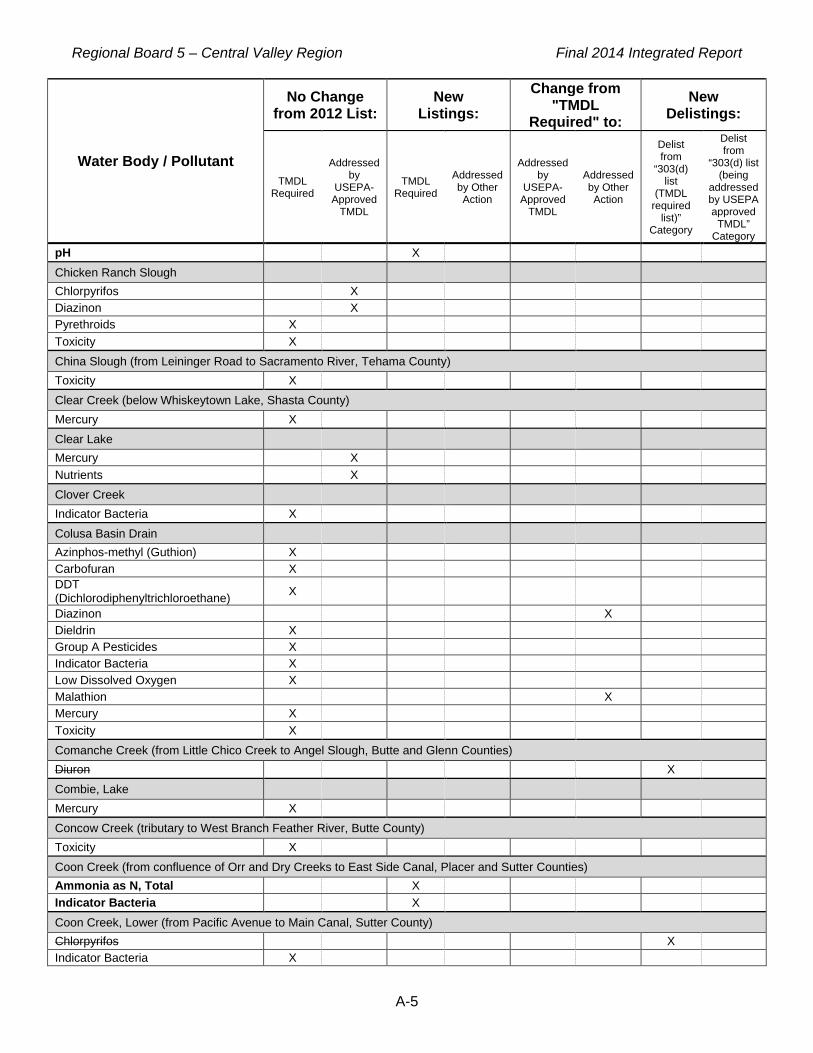
Regional Board 5 – Central Valley Region Final 2014 Integrated Report
A-5
Water Body / Pollutant
No Change from 2012 List:
New Listings:
Change from "TMDL
Required" to: New
Delistings:
TMDL Required
Addressed by
USEPA-Approved
TMDL
TMDL Required
Addressed by Other Action
Addressed by
USEPA-Approved
TMDL
Addressed by Other Action
Delist from
“303(d) list
(TMDL required
list)” Category
Delist from
“303(d) list (being
addressed by USEPA approved
TMDL” Category
pH X Chicken Ranch Slough Chlorpyrifos X Diazinon X Pyrethroids X Toxicity X China Slough (from Leininger Road to Sacramento River, Tehama County) Toxicity X Clear Creek (below Whiskeytown Lake, Shasta County) Mercury X Clear Lake Mercury X Nutrients X Clover Creek Indicator Bacteria X Colusa Basin Drain Azinphos-methyl (Guthion) X Carbofuran X DDT (Dichlorodiphenyltrichloroethane) X Diazinon X Dieldrin X Group A Pesticides X Indicator Bacteria X Low Dissolved Oxygen X Malathion X Mercury X Toxicity X Comanche Creek (from Little Chico Creek to Angel Slough, Butte and Glenn Counties) Diuron X Combie, Lake Mercury X Concow Creek (tributary to West Branch Feather River, Butte County) Toxicity X Coon Creek (from confluence of Orr and Dry Creeks to East Side Canal, Placer and Sutter Counties) Ammonia as N, Total X Indicator Bacteria X Coon Creek, Lower (from Pacific Avenue to Main Canal, Sutter County) Chlorpyrifos X Indicator Bacteria X
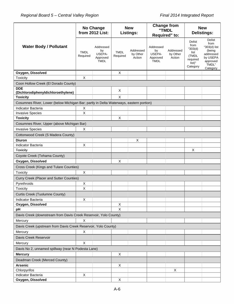
Regional Board 5 – Central Valley Region Final 2014 Integrated Report
A-6
Water Body / Pollutant
No Change from 2012 List:
New Listings:
Change from "TMDL
Required" to: New
Delistings:
TMDL Required
Addressed by
USEPA-Approved
TMDL
TMDL Required
Addressed by Other Action
Addressed by
USEPA-Approved
TMDL
Addressed by Other Action
Delist from
“303(d) list
(TMDL required
list)” Category
Delist from
“303(d) list (being
addressed by USEPA approved
TMDL” Category
Oxygen, Dissolved X Toxicity X Coon Hollow Creek (El Dorado County) DDE (Dichlorodiphenyldichloroethylene) X Toxicity X Cosumnes River, Lower (below Michigan Bar; partly in Delta Waterways, eastern portion) Indicator Bacteria X Invasive Species X Toxicity X Cosumnes River, Upper (above Michigan Bar) Invasive Species X Cottonwood Creek (S Madera County) Diuron X Indicator Bacteria X Toxicity X Coyote Creek (Tehama County) Oxygen, Dissolved X Cross Creek (Kings and Tulare Counties) Toxicity X Curry Creek (Placer and Sutter Counties) Pyrethroids X Toxicity X Curtis Creek (Tuolumne County) Indicator Bacteria X Oxygen, Dissolved X pH X Davis Creek (downstream from Davis Creek Reservoir, Yolo County) Mercury X Davis Creek (upstream from Davis Creek Reservoir, Yolo County) Mercury X Davis Creek Reservoir Mercury X Davis No 2, unnamed spillway (near N Podesta Lane) Mercury X Deadman Creek (Merced County) Arsenic X Chlorpyrifos X Indicator Bacteria X Oxygen, Dissolved X

Regional Board 5 – Central Valley Region Final 2014 Integrated Report
A-7
Water Body / Pollutant
No Change from 2012 List:
New Listings:
Change from "TMDL
Required" to: New
Delistings:
TMDL Required
Addressed by
USEPA-Approved
TMDL
TMDL Required
Addressed by Other Action
Addressed by
USEPA-Approved
TMDL
Addressed by Other Action
Delist from
“303(d) list
(TMDL required
list)” Category
Delist from
“303(d) list (being
addressed by USEPA approved
TMDL” Category
Toxicity X Deep Slough (Merced County) pH X Deer Creek (from Deer Creek Reservoir to Lake Wildwood, Nevada County) Indicator Bacteria X Mercury X pH X Deer Creek (Nevada County, Above Scotts Flat Reservoir to the Confluence of Deer Creek North and South Forks) pH X Deer Creek (Sacramento County) Iron X Deer Creek (Tulare County) Chlorpyrifos X pH (high) X Toxicity X Deer Creek (Yuba County) pH X Del Puerto Creek Bifenthrin X Chlorpyrifos X Cyfluthrin X Cyhalothrin, Lambda X Diazinon X Dieldrin X Dimethoate X Diuron X Esfenvalerate/Fenvalerate X Indicator Bacteria X Nitrate/Nitrite (Nitrite + Nitrate as N) X pH (high) X Pyrethroids X Salinity X Total Dissolved Solids X Toxicity X Delta Waterways (central portion) Chlorpyrifos X DDT (Dichlorodiphenyltrichloroethane) X Diazinon X Group A Pesticides X Invasive Species X

Regional Board 5 – Central Valley Region Final 2014 Integrated Report
A-8
Water Body / Pollutant
No Change from 2012 List:
New Listings:
Change from "TMDL
Required" to: New
Delistings:
TMDL Required
Addressed by
USEPA-Approved
TMDL
TMDL Required
Addressed by Other Action
Addressed by
USEPA-Approved
TMDL
Addressed by Other Action
Delist from
“303(d) list
(TMDL required
list)” Category
Delist from
“303(d) list (being
addressed by USEPA approved
TMDL” Category
Mercury X Toxicity X Delta Waterways (eastern portion) Chlorpyrifos X DDT (Dichlorodiphenyltrichloroethane) X Diazinon X Group A Pesticides X Invasive Species X Mercury X Toxicity X Delta Waterways (export area) Chlorpyrifos X DDT (Dichlorodiphenyltrichloroethane) X Diazinon X Electrical Conductivity X Group A Pesticides X Invasive Species X Mercury X Toxicity X Delta Waterways (northern portion) Chlordane X Chlorpyrifos X DDT (Dichlorodiphenyltrichloroethane) X Diazinon X Dieldrin X Group A Pesticides X Invasive Species X Mercury X PCBs (Polychlorinated biphenyls) X Toxicity X Delta Waterways (northwestern portion) Chlorpyrifos X DDT (Dichlorodiphenyltrichloroethane) X Diazinon X Electrical Conductivity X Group A Pesticides X Invasive Species X Mercury X Toxicity X

Regional Board 5 – Central Valley Region Final 2014 Integrated Report
A-9
Water Body / Pollutant
No Change from 2012 List:
New Listings:
Change from "TMDL
Required" to: New
Delistings:
TMDL Required
Addressed by
USEPA-Approved
TMDL
TMDL Required
Addressed by Other Action
Addressed by
USEPA-Approved
TMDL
Addressed by Other Action
Delist from
“303(d) list
(TMDL required
list)” Category
Delist from
“303(d) list (being
addressed by USEPA approved
TMDL” Category
Delta Waterways (southern portion) Chlorpyrifos X DDT (Dichlorodiphenyltrichloroethane) X Diazinon X Electrical Conductivity X Group A Pesticides X Invasive Species X Mercury X Toxicity X Delta Waterways (Stockton Ship Channel) Chlorpyrifos X DDT (Dichlorodiphenyltrichloroethane) X Diazinon X Dioxin X Furan Compounds X Group A Pesticides X Indicator Bacteria X Invasive Species X Mercury X Organic Enrichment/Low Dissolved Oxygen X PCBs (Polychlorinated biphenyls) X Temperature, water X Toxicity X Delta Waterways (western portion) Arsenic X Chlordane X Chlorpyrifos X DDT (Dichlorodiphenyltrichloroethane) X Diazinon X Dieldrin X Electrical Conductivity X Group A Pesticides X Invasive Species X Mercury X PAHs (Polycyclic Aromatic Hydrocarbons) X PCBs (Polychlorinated biphenyls) X Total DDT (sum of 4,4'- and 2,4'- isomers of DDT, DDE, and DDD) X Toxicity X

Regional Board 5 – Central Valley Region Final 2014 Integrated Report
A-10
Water Body / Pollutant
No Change from 2012 List:
New Listings:
Change from "TMDL
Required" to: New
Delistings:
TMDL Required
Addressed by
USEPA-Approved
TMDL
TMDL Required
Addressed by Other Action
Addressed by
USEPA-Approved
TMDL
Addressed by Other Action
Delist from
“303(d) list
(TMDL required
list)” Category
Delist from
“303(d) list (being
addressed by USEPA approved
TMDL” Category
Discovery Bay Mercury X Dolly Creek Copper X Zinc X Don Pedro Lake Mercury X Dry Creek (Madera County) Diazinon X Diuron X Toxicity X Dry Creek (Placer and Sacramento Counties) Indicator Bacteria X Dry Creek (tributary to Tuolumne River at Modesto, E Stanislaus County) Chlorpyrifos X Diazinon X Diuron X Indicator Bacteria X Oxygen, Dissolved X Toxicity X Duck Creek (San Joaquin County) Chlorpyrifos X Indicator Bacteria X Mercury X Toxicity X Duck Slough (in Delta Waterways, northern portion) Chlorpyrifos X Duck Slough (Merced County) Chlorpyrifos X Indicator Bacteria X Toxicity X Dunn Creek (Mt Diablo Mine to Marsh Creek) Mercury X Metals X East Park Reservoir Mercury X Eastman Lake (Madera County) Mercury X Eastman Lake (Shasta County)

Regional Board 5 – Central Valley Region Final 2014 Integrated Report
A-11
Water Body / Pollutant
No Change from 2012 List:
New Listings:
Change from "TMDL
Required" to: New
Delistings:
TMDL Required
Addressed by
USEPA-Approved
TMDL
TMDL Required
Addressed by Other Action
Addressed by
USEPA-Approved
TMDL
Addressed by Other Action
Delist from
“303(d) list
(TMDL required
list)” Category
Delist from
“303(d) list (being
addressed by USEPA approved
TMDL” Category
pH X Elbow Creek (from Mathews Ditch to Cottonwood Creek, Tulare County) Chlorpyrifos X Elder Creek Chlorpyrifos X Diazinon X Pyrethroids X Toxicity X Elk Bayou (Tulare County) Chlorpyrifos X Dimethoate X Oxygen, Dissolved X pH X Toxicity X Elk Grove Creek Chlorpyrifos X Diazinon X Englebright Lake Mercury X Fall River (Pit) Sedimentation/Siltation X Fall River, tributary to Feather River, Middle Fork (Butte and Plumas Counties) Toxicity X Feather River, Lower (Lake Oroville Dam to Confluence with Sacramento River) Chlorpyrifos X Group A Pesticides X Mercury X PCBs (Polychlorinated biphenyls) X Toxicity X Feather River, Middle Fork (Sierra Valley to Lake Oroville, Butte and Plumas Counties) Toxicity X Feather River, North Fork (below Lake Almanor) Mercury X PCBs (Polychlorinated biphenyls) X Temperature, water X Toxicity X Feather River, South Fork (from Little Grass Valley Reservoir to Lake Oroville, Butte and Plumas Counties) PCBs (Polychlorinated biphenyls) X Toxicity X Feather River, West Branch (from Griffin Gulch to Lake Oroville)

Regional Board 5 – Central Valley Region Final 2014 Integrated Report
A-12
Water Body / Pollutant
No Change from 2012 List:
New Listings:
Change from "TMDL
Required" to: New
Delistings:
TMDL Required
Addressed by
USEPA-Approved
TMDL
TMDL Required
Addressed by Other Action
Addressed by
USEPA-Approved
TMDL
Addressed by Other Action
Delist from
“303(d) list
(TMDL required
list)” Category
Delist from
“303(d) list (being
addressed by USEPA approved
TMDL” Category
Toxicity X Fingers Lake Mercury X Five Mile Slough (Alexandria Place to Fourteen Mile Slough; in Delta Waterways, eastern portion) Chlorpyrifos X Diazinon X Indicator Bacteria X Organic Enrichment/Low Dissolved Oxygen X Folsom Lake Mercury X French Camp Slough (confluence of Littlejohns and Lone Tree Creeks to San Joaquin River, San Joaquin Co; partly in Delta Waterways, eastern portion) Chlorpyrifos X Diazinon X Indicator Bacteria X Oxygen, Dissolved X Toxicity X French Ravine Indicator Bacteria X Freshwater Creek (Little Valley to Salt Creek, Colusa County) Indicator Bacteria X Fresno River (Above Hensley Reservoir to confl w Nelder Creek and Lewis Fork) Low Dissolved Oxygen X Fresno Slough (from Graham Road to James Bypass, Fresno County) Chlorpyrifos X Toxicity X Gilsizer Slough (from Yuba City to downstream of Township Road, Sutter County) Diazinon X Diuron X Oxyfluorfen X Oxygen, Dissolved X pH X Toxicity X Gold Run (Nevada County) Mercury X Gordon Slough (from headwaters and Goodnow Slough to Adams Canal, Yolo County) Oxygen, Dissolved X Grant Line Canal subwatershed at Clifton Court Rd (San Joaquin County) Specific Conductivity X

Regional Board 5 – Central Valley Region Final 2014 Integrated Report
A-13
Water Body / Pollutant
No Change from 2012 List:
New Listings:
Change from "TMDL
Required" to: New
Delistings:
TMDL Required
Addressed by
USEPA-Approved
TMDL
TMDL Required
Addressed by Other Action
Addressed by
USEPA-Approved
TMDL
Addressed by Other Action
Delist from
“303(d) list
(TMDL required
list)” Category
Delist from
“303(d) list (being
addressed by USEPA approved
TMDL” Category
Grant Line Canal subwatershed near Calpack Rd (San Joaquin County) Specific Conductivity X Grasslands Marshes Electrical Conductivity X Selenium X Grayson Drain (at outfall) Indicator Bacteria X Toxicity X Hamilton Slough (from south of Thermalito Afterbay to south of Biggs, Butte County) Toxicity X Harding Drain alpha.-BHC (Benzenehexachloride or alpha-HCH) X Chlorpyrifos X DDE (Dichlorodiphenyldichloroethylene) X Hexachlorobenzene/ HCB X Indicator Bacteria X Lindane/gamma Hexachlorocyclohexane (gamma-HCH)
X
Harley Gulch Mercury X Hell Hole Reservoir Mercury X Hensley Lake Mercury X Oxygen, Dissolved X pH X Hetch Hetchy Reservoir Mercury X Highline Canal (from Mustang Creek to Lateral No 8, Merced and Stanislaus Counties) Chlorpyrifos X Simazine X Toxicity X Honcut Creek (Butte and Yuba Counties) Indicator Bacteria X Oxygen, Dissolved X Horse Creek (Rising Star Mine to Shasta Lake) Cadmium X Copper X

Regional Board 5 – Central Valley Region Final 2014 Integrated Report
A-14
Water Body / Pollutant
No Change from 2012 List:
New Listings:
Change from "TMDL
Required" to: New
Delistings:
TMDL Required
Addressed by
USEPA-Approved
TMDL
TMDL Required
Addressed by Other Action
Addressed by
USEPA-Approved
TMDL
Addressed by Other Action
Delist from
“303(d) list
(TMDL required
list)” Category
Delist from
“303(d) list (being
addressed by USEPA approved
TMDL” Category
Lead X pH X Zinc X Hospital Creek (San Joaquin and Stanislaus Counties) Arsenic X Chlorpyrifos X DDE (Dichlorodiphenyldichloroethylene) X DDT (Dichlorodiphenyltrichloroethane) X Dieldrin X Dimethoate X Diuron X Indicator Bacteria X Methyl Parathion X Pyrethroids X Salinity X Specific Conductivity X Total Dissolved Solids X Toxicity X Trifluralin X Humbug Creek (Diggins Creek to Yuba River, South Fork) Chromium X Copper X Iron X Mercury X pH X Sedimentation/Siltation X Zinc X Hume Lake Oxygen, Dissolved X pH X Indian Creek (from Antelope Lake to East Branch of North Fork Feather River, Plumas County) Oxygen, Dissolved X Indian Valley Reservoir (Lake County) Mercury X Ingalsbe Slough (tributary to Merced River, Merced County) Toxicity X Ingram Creek (from confluence with Hospital Creek to Hwy 33 crossing) Arsenic X Chlorpyrifos X DDT X
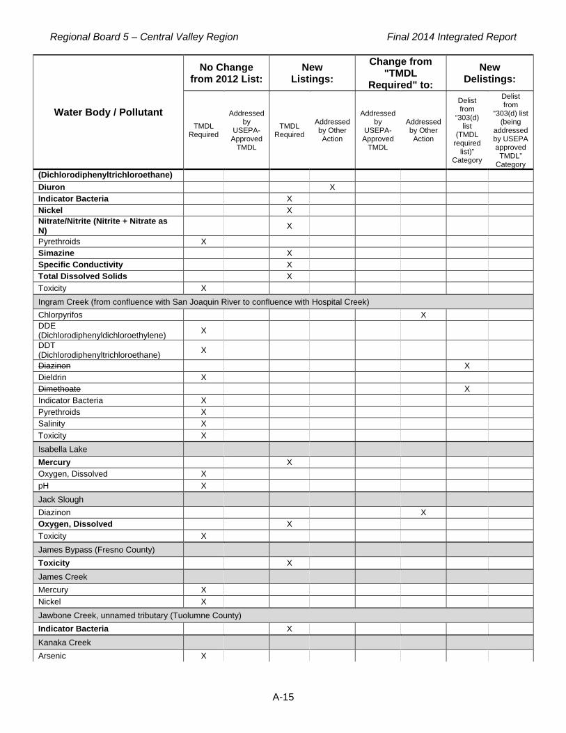
Regional Board 5 – Central Valley Region Final 2014 Integrated Report
A-15
Water Body / Pollutant
No Change from 2012 List:
New Listings:
Change from "TMDL
Required" to: New
Delistings:
TMDL Required
Addressed by
USEPA-Approved
TMDL
TMDL Required
Addressed by Other Action
Addressed by
USEPA-Approved
TMDL
Addressed by Other Action
Delist from
“303(d) list
(TMDL required
list)” Category
Delist from
“303(d) list (being
addressed by USEPA approved
TMDL” Category
(Dichlorodiphenyltrichloroethane) Diuron X Indicator Bacteria X Nickel X Nitrate/Nitrite (Nitrite + Nitrate as N) X Pyrethroids X Simazine X Specific Conductivity X Total Dissolved Solids X Toxicity X Ingram Creek (from confluence with San Joaquin River to confluence with Hospital Creek) Chlorpyrifos X DDE (Dichlorodiphenyldichloroethylene) X DDT (Dichlorodiphenyltrichloroethane) X Diazinon X Dieldrin X Dimethoate X Indicator Bacteria X Pyrethroids X Salinity X Toxicity X Isabella Lake Mercury X Oxygen, Dissolved X pH X Jack Slough Diazinon X Oxygen, Dissolved X Toxicity X James Bypass (Fresno County) Toxicity X James Creek Mercury X Nickel X Jawbone Creek, unnamed tributary (Tuolumne County) Indicator Bacteria X Kanaka Creek Arsenic X

Regional Board 5 – Central Valley Region Final 2014 Integrated Report
A-16
Water Body / Pollutant
No Change from 2012 List:
New Listings:
Change from "TMDL
Required" to: New
Delistings:
TMDL Required
Addressed by
USEPA-Approved
TMDL
TMDL Required
Addressed by Other Action
Addressed by
USEPA-Approved
TMDL
Addressed by Other Action
Delist from
“303(d) list
(TMDL required
list)” Category
Delist from
“303(d) list (being
addressed by USEPA approved
TMDL” Category
Kaseberg Creek (tributary to Pleasant Grove Creek, Placer County) Bifenthrin X Cyfluthrin X Cyhalothrin, Lambda X Cypermethrin X Deltamethrin X Pyrethroids X Toxicity X Kaseberg Creek, unnamed eastern tributary (from Green Grove Ln to Del Webb Blvd) Bifenthrin X Cyfluthrin X Cyhalothrin, Lambda X Cypermethrin X Toxicity X Kaseberg Creek, unnamed southeastern tributary (from Silverado Middle School to Timber Creek Golf Course, Placer County) Bifenthrin X Cyfluthrin X Cyhalothrin, Lambda X Cypermethrin X Deltamethrin X Toxicity X Kaseberg Creek, unnamed southern tributary (from Baseline Road to Timber Creek Golf Course, Placer County) Bifenthrin X Cyfluthrin X Cyhalothrin, Lambda X Cypermethrin X Deltamethrin X Toxicity X Kaweah Lake Mercury X Kaweah River (below Terminus Dam, Tulare County) pH X Toxicity X Kaweah River, Lower (includes St Johns River) Toxicity X Kellogg Creek (Los Vaqueros Reservoir to Discovery Bay; partly in Delta Waterways, western portion) Indicator Bacteria X Oxygen, Dissolved X Salinity X Toxicity X Kentucky Creek (Nevada County)

Regional Board 5 – Central Valley Region Final 2014 Integrated Report
A-17
Water Body / Pollutant
No Change from 2012 List:
New Listings:
Change from "TMDL
Required" to: New
Delistings:
TMDL Required
Addressed by
USEPA-Approved
TMDL
TMDL Required
Addressed by Other Action
Addressed by
USEPA-Approved
TMDL
Addressed by Other Action
Delist from
“303(d) list
(TMDL required
list)” Category
Delist from
“303(d) list (being
addressed by USEPA approved
TMDL” Category
Oxygen, Dissolved X pH X Keswick Reservoir (portion downstream from Spring Creek) Cadmium X Copper X Zinc X Kings River, Lower (Island Weir to Stinson and Empire Weirs) Electrical Conductivity X Molybdenum X Toxaphene X Kings River, Lower (Pine Flat Reservoir to Island Weir) Alkalinity as CaCO3 X Chlorpyrifos X Toxicity X Knights Landing Ridge Cut (Yolo County) Boron X Oxygen, Dissolved X Salinity X Laguna Creek (tributary to Cosumnes River, Sacramento County) Indicator Bacteria X Oxygen, Dissolved X Toxicity X Langworth Pipeline (Stanislaus County) Oxygen, Dissolved X Lassen Creek (Modoc County) Toxicity X Little Backbone Creek, Lower Acid Mine Drainage X Cadmium X Copper X Zinc X Little Cow Creek (downstream from Afterthought Mine) Cadmium X Copper X Zinc X Little Deer Creek Mercury X pH X Little Grizzly Creek Copper X

Regional Board 5 – Central Valley Region Final 2014 Integrated Report
A-18
Water Body / Pollutant
No Change from 2012 List:
New Listings:
Change from "TMDL
Required" to: New
Delistings:
TMDL Required
Addressed by
USEPA-Approved
TMDL
TMDL Required
Addressed by Other Action
Addressed by
USEPA-Approved
TMDL
Addressed by Other Action
Delist from
“303(d) list
(TMDL required
list)” Category
Delist from
“303(d) list (being
addressed by USEPA approved
TMDL” Category
Zinc X Little Panoche Creek Toxicity X Littlejohns Creek Chlorpyrifos X Indicator Bacteria X Toxicity X Live Oak Slough Diazinon X Oxyfluorfen X Oxygen, Dissolved X Lone Tree Creek Ammonia X BOD, Biochemical oxygen demand X Chlorpyrifos X Diazinon X Diuron X Indicator Bacteria X Toxicity X Lone Willow Slough (Madera County) Toxicity X Loon Lake Mercury X Los Banos Creek (below Los Banos Reservoir, Merced County) Boron X Indicator Bacteria X Oxygen, Dissolved X Total Dissolved Solids X Toxicity X Los Banos Reservoir Mercury X Los Gatos Creek (Fresno County) Lead X Selenium X Los Vaqueros Reservoir Mercury X Lower Blue Lake Mercury X Main Drain (Kern County) Boron X

Regional Board 5 – Central Valley Region Final 2014 Integrated Report
A-19
Water Body / Pollutant
No Change from 2012 List:
New Listings:
Change from "TMDL
Required" to: New
Delistings:
TMDL Required
Addressed by
USEPA-Approved
TMDL
TMDL Required
Addressed by Other Action
Addressed by
USEPA-Approved
TMDL
Addressed by Other Action
Delist from
“303(d) list
(TMDL required
list)” Category
Delist from
“303(d) list (being
addressed by USEPA approved
TMDL” Category
Diuron X Oxygen, Dissolved X Toxicity X Main Drainage Canal Diazinon X Diuron X Oxygen, Dissolved X Marsh Creek (Dunn Creek to Marsh Creek Reservoir) Mercury X Metals X Marsh Creek (Marsh Creek Reservoir to San Joaquin River; partly in Delta Waterways, western portion) Diazinon X Indicator Bacteria X Mercury X Toxicity X Marsh Creek Reservoir Mercury X McClure Reservoir (Mariposa County) Mercury X Meadows Slough (Sacramento County) Mercury X Mendota Pool Mercury X Selenium X Merced River, Lower (McSwain Reservoir to San Joaquin River) Chlorpyrifos X Diazinon X Indicator Bacteria X Group A Pesticides X Mercury X Temperature, water X Toxicity X Merle Collins Lake Mercury X Middle River (in Delta Waterways, southern portion) Low Dissolved Oxygen X Mile Long Pond (Butte County) Mercury X Toxicity X

Regional Board 5 – Central Valley Region Final 2014 Integrated Report
A-20
Water Body / Pollutant
No Change from 2012 List:
New Listings:
Change from "TMDL
Required" to: New
Delistings:
TMDL Required
Addressed by
USEPA-Approved
TMDL
TMDL Required
Addressed by Other Action
Addressed by
USEPA-Approved
TMDL
Addressed by Other Action
Delist from
“303(d) list
(TMDL required
list)” Category
Delist from
“303(d) list (being
addressed by USEPA approved
TMDL” Category
Miles Creek (Merced County) Diuron X Indicator Bacteria X Oxygen, Dissolved X Toxicity X Mill Creek (Fresno County) Toxicity X Mill Creek (Tehama County) Mercury X Mill Creek (Tulare County) Ammonia (Unionized) X Toxicity X Millerton Lake Mercury X Miners Ravine (Placer County) Oxygen, Dissolved X Modesto Reservoir Mercury X Mokelumne River, Lower (in Delta Waterways, eastern portion) Chlorpyrifos X Copper X Mercury X Oxygen, Dissolved X Toxicity X Zinc X Moon Lake Mercury X Mormon Slough (Commerce Street to Stockton Deep Water Channel; partly in Delta Waterways, eastern portion) Indicator Bacteria X Organic Enrichment/Low Dissolved Oxygen X Mormon Slough (from Stockton Diverting Canal to Bellota Weir--Calaveras River) Chlorpyrifos X Toxicity X Mormon Slough (Stockton Diverting Canal to Commerce Street) Indicator Bacteria X Morrison Creek Diazinon X Pentachlorophenol (PCP) X Pyrethroids X

Regional Board 5 – Central Valley Region Final 2014 Integrated Report
A-21
Water Body / Pollutant
No Change from 2012 List:
New Listings:
Change from "TMDL
Required" to: New
Delistings:
TMDL Required
Addressed by
USEPA-Approved
TMDL
TMDL Required
Addressed by Other Action
Addressed by
USEPA-Approved
TMDL
Addressed by Other Action
Delist from
“303(d) list
(TMDL required
list)” Category
Delist from
“303(d) list (being
addressed by USEPA approved
TMDL” Category
Toxicity X Morrison Slough Diazinon X Mosher Slough (downstream of I-5; in Delta Waterways, eastern portion) Chlorpyrifos X Diazinon X Indicator Bacteria X Mercury X Organic Enrichment/Low Dissolved Oxygen X Mosher Slough (upstream of I-5; partly in Delta Waterways, eastern portion) Indicator Bacteria X Mountain House Creek (from Altamont Pass to Old River, Alameda and San Joaquin Counties; partly in Delta Waterways, southern portion) Chloride X Salinity X Mud Creek (Butte County) Toxicity X Mud Slough, North (downstream of San Luis Drain) Boron X Electrical Conductivity X Pesticides X Selenium X Toxicity X Mud Slough, North (upstream of San Luis Drain) Boron X Electrical Conductivity X Indicator Bacteria X Pesticides X Toxicity X Mustang Creek (Merced County) Chlorpyrifos X cis-permethrin X Diazinon X Indicator Bacteria X Nitrate/Nitrite (Nitrite + Nitrate as N) X Oxygen, Dissolved X Simazine X Total Dissolved Solids X Toxicity X Natoma, Lake
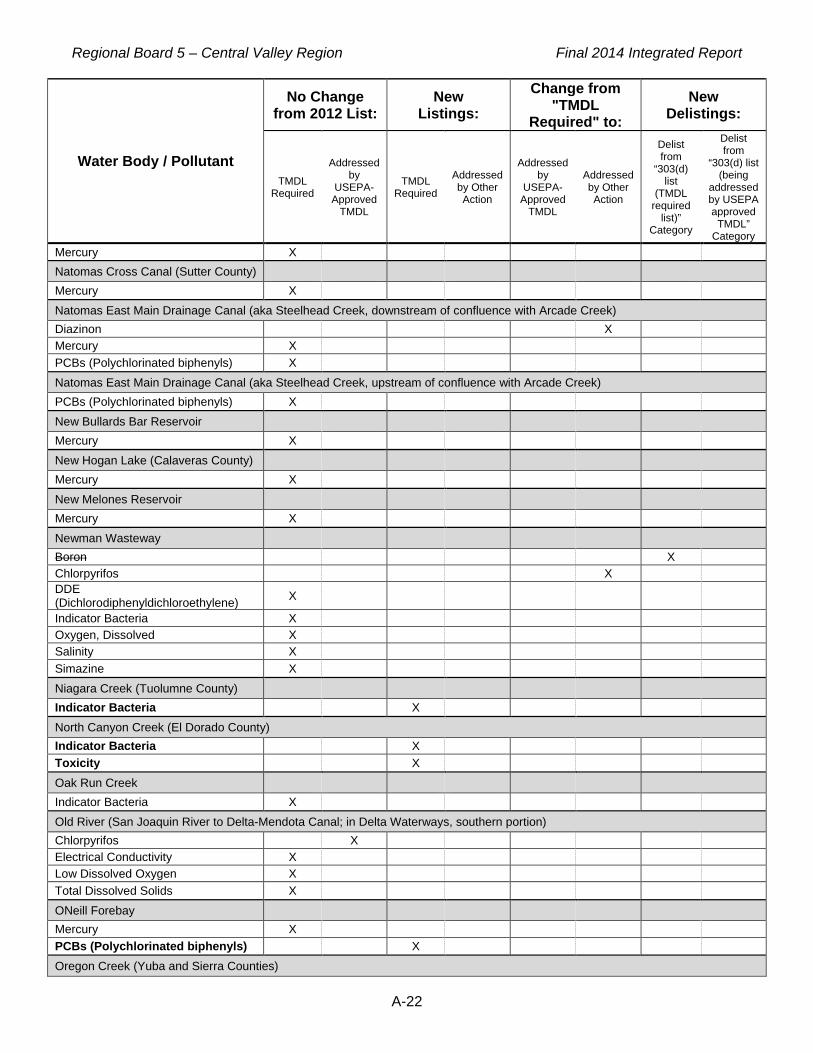
Regional Board 5 – Central Valley Region Final 2014 Integrated Report
A-22
Water Body / Pollutant
No Change from 2012 List:
New Listings:
Change from "TMDL
Required" to: New
Delistings:
TMDL Required
Addressed by
USEPA-Approved
TMDL
TMDL Required
Addressed by Other Action
Addressed by
USEPA-Approved
TMDL
Addressed by Other Action
Delist from
“303(d) list
(TMDL required
list)” Category
Delist from
“303(d) list (being
addressed by USEPA approved
TMDL” Category
Mercury X Natomas Cross Canal (Sutter County) Mercury X Natomas East Main Drainage Canal (aka Steelhead Creek, downstream of confluence with Arcade Creek) Diazinon X Mercury X PCBs (Polychlorinated biphenyls) X Natomas East Main Drainage Canal (aka Steelhead Creek, upstream of confluence with Arcade Creek) PCBs (Polychlorinated biphenyls) X New Bullards Bar Reservoir Mercury X New Hogan Lake (Calaveras County) Mercury X New Melones Reservoir Mercury X Newman Wasteway Boron X Chlorpyrifos X DDE (Dichlorodiphenyldichloroethylene) X Indicator Bacteria X Oxygen, Dissolved X Salinity X Simazine X Niagara Creek (Tuolumne County) Indicator Bacteria X North Canyon Creek (El Dorado County) Indicator Bacteria X Toxicity X Oak Run Creek Indicator Bacteria X Old River (San Joaquin River to Delta-Mendota Canal; in Delta Waterways, southern portion) Chlorpyrifos X Electrical Conductivity X Low Dissolved Oxygen X Total Dissolved Solids X ONeill Forebay Mercury X PCBs (Polychlorinated biphenyls) X Oregon Creek (Yuba and Sierra Counties)

Regional Board 5 – Central Valley Region Final 2014 Integrated Report
A-23
Water Body / Pollutant
No Change from 2012 List:
New Listings:
Change from "TMDL
Required" to: New
Delistings:
TMDL Required
Addressed by
USEPA-Approved
TMDL
TMDL Required
Addressed by Other Action
Addressed by
USEPA-Approved
TMDL
Addressed by Other Action
Delist from
“303(d) list
(TMDL required
list)” Category
Delist from
“303(d) list (being
addressed by USEPA approved
TMDL” Category
Copper X Orestimba Creek (above Kilburn Road) Azinphos-methyl (Guthion) X Chlorpyrifos X DDE (Dichlorodiphenyldichloroethylene) X DDT (Dichlorodiphenyltrichloroethane) X Diazinon X Dieldrin X Dimethoate X Diuron X Indicator Bacteria X Oxygen, Dissolved X Specific Conductivity X Total Dissolved Solids X Toxicity X Orestimba Creek (below Kilburn Road) Azinphos-methyl (Guthion) X Chlorpyrifos X DDD (Dichlorodiphenyldichloroethane) X DDE (Dichlorodiphenyldichloroethylene) X DDT (Dichlorodiphenyltrichloroethane) X Diazinon X Dieldrin X Dimethoate X Diuron X Indicator Bacteria X Malathion X Specific Conductivity X Total Dissolved Solids X Toxicity X Oroville Wildlife Area Fishing Pond (Butte County) Toxicity X Oroville, Lake Mercury X PCBs (Polychlorinated biphenyls) X Outside Creek (Tulare County) Toxicity X Oxbow Reservoir (Ralston Afterbay, El Dorado and Placer Counties)
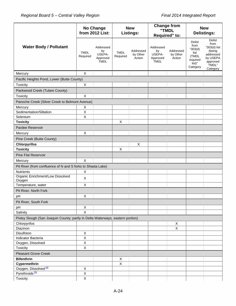
Regional Board 5 – Central Valley Region Final 2014 Integrated Report
A-24
Water Body / Pollutant
No Change from 2012 List:
New Listings:
Change from "TMDL
Required" to: New
Delistings:
TMDL Required
Addressed by
USEPA-Approved
TMDL
TMDL Required
Addressed by Other Action
Addressed by
USEPA-Approved
TMDL
Addressed by Other Action
Delist from
“303(d) list
(TMDL required
list)” Category
Delist from
“303(d) list (being
addressed by USEPA approved
TMDL” Category
Mercury X Pacific Heights Pond, Lower (Butte County) Toxicity X Packwood Creek (Tulare County) Toxicity X Panoche Creek (Silver Creek to Belmont Avenue) Mercury X Sedimentation/Siltation X Selenium X Toxicity X Pardee Reservoir Mercury X Pine Creek (Butte County) Chlorpyrifos X Toxicity X Pine Flat Reservoir Mercury X Pit River (from confluence of N and S forks to Shasta Lake) Nutrients X Organic Enrichment/Low Dissolved Oxygen X Temperature, water X Pit River, North Fork pH X Pit River, South Fork pH X Salinity X Pixley Slough (San Joaquin County; partly in Delta Waterways, eastern portion) Chlorpyrifos X Diazinon X Disulfoton X Indicator Bacteria X Oxygen, Dissolved X Toxicity X Pleasant Grove Creek Bifenthrin X Cypermethrin X Oxygen, Dissolved (a) X Pyrethroids (b) X Toxicity X

Regional Board 5 – Central Valley Region Final 2014 Integrated Report
A-25
Water Body / Pollutant
No Change from 2012 List:
New Listings:
Change from "TMDL
Required" to: New
Delistings:
TMDL Required
Addressed by
USEPA-Approved
TMDL
TMDL Required
Addressed by Other Action
Addressed by
USEPA-Approved
TMDL
Addressed by Other Action
Delist from
“303(d) list
(TMDL required
list)” Category
Delist from
“303(d) list (being
addressed by USEPA approved
TMDL” Category
Pleasant Grove Creek, South Branch Bifenthrin X Cyfluthrin X Cypermethrin X Deltamethrin X Oxygen, Dissolved X Pyrethroids X Toxicity X Pleasant Grove Creek, South Branch, unnamed southeastern trib (from east of Sierra View Country Club to confl with Pleasant Grove Cr, South Branch) Bifenthrin X Cyfluthrin X Cypermethrin X Toxicity X Pleasant Grove Creek, unnamed northern tributary (from Greywood Circle to confluence with Pleasant Grove Creek) Bifenthrin X Cyfluthrin X Cypermethrin X Toxicity X Pleasant Grove Creek, unnamed northern tributary (from Mt Tamalpais Dr to confluence with Pleasant Grove Creek) Bifenthrin X Cyfluthrin X Cyhalothrin, Lambda X Cypermethrin X Deltamethrin X Permethrin, total X Toxicity X Poorman Creek (Nevada County) Copper X pH X Poso Slough Toxicity X Potato Slough, Little (San Joaquin County) Toxicity X Putah Creek (Solano Lake to Putah Creek Sinks; partly in Delta Waterways, northwestern portion) Boron X Mercury X Ramona Lake Diuron X Indicator Bacteria X Oxygen, Dissolved X

Regional Board 5 – Central Valley Region Final 2014 Integrated Report
A-26
Water Body / Pollutant
No Change from 2012 List:
New Listings:
Change from "TMDL
Required" to: New
Delistings:
TMDL Required
Addressed by
USEPA-Approved
TMDL
TMDL Required
Addressed by Other Action
Addressed by
USEPA-Approved
TMDL
Addressed by Other Action
Delist from
“303(d) list
(TMDL required
list)” Category
Delist from
“303(d) list (being
addressed by USEPA approved
TMDL” Category
pH X Specific Conductivity X Total Dissolved Solids X Toxicity X Ramona Lake (Fresno County) Dimethoate X Indicator Bacteria X Salinity X Toxicity X Rattlesnake Creek (at confluence w Mokelumne River, N Fork) Indicator Bacteria X Robinsons Riffle Pond (Butte County) Mercury X PCBs (Polychlorinated biphenyls) X Rock Creek (Nevada County) pH X Rock Creek (Placer County) Indicator Bacteria X Rollins Reservoir Mercury X Rose Creek (Tuolumne County) Indicator Bacteria X Rush Creek (Modoc County) pH X Sacramento River (Keswick Dam to Cottonwood Creek) Toxicity X Sacramento River ( Cottonwood Creek to Red Bluff) Mercury X Toxicity X Sacramento River ( Red Bluff to Knights Landing) DDT (Dichlorodiphenyltrichloroethane) X Dieldrin X Mercury X PCBs (Polychlorinated biphenyls) X Toxicity X Sacramento River (Knights Landing to the Delta) Chlordane X DDT (Dichlorodiphenyltrichloroethane) X

Regional Board 5 – Central Valley Region Final 2014 Integrated Report
A-27
Water Body / Pollutant
No Change from 2012 List:
New Listings:
Change from "TMDL
Required" to: New
Delistings:
TMDL Required
Addressed by
USEPA-Approved
TMDL
TMDL Required
Addressed by Other Action
Addressed by
USEPA-Approved
TMDL
Addressed by Other Action
Delist from
“303(d) list
(TMDL required
list)” Category
Delist from
“303(d) list (being
addressed by USEPA approved
TMDL” Category
Dieldrin X Mercury X PCBs (Polychlorinated biphenyls) X Toxicity X Sacramento Slough Chlorpyrifos X Mercury X Oxygen, Dissolved X pH (low) X Toxicity X Salado Creek (Stanislaus County) Indicator Bacteria X Salinity X Salt Slough (Mud Slough to Sand Dam, Merced County) Chlorpyrifos X Toxicity X Salt Slough (upstream from confluence with San Joaquin River) Boron X Chlorpyrifos X Electrical Conductivity X Indicator Bacteria X Mercury X Oxygen, Dissolved X Prometryn X Toxicity X San Carlos Creek (downstream of New Idria Mine) Mercury X San Joaquin River ( Mendota Pool to Bear Creek) Boron X Chlorpyrifos X DDT (Dichlorodiphenyltrichloroethane) X Diazinon X Group A Pesticides X Toxicity X San Joaquin River (Bear Creek to Mud Slough) Arsenic X Boron X Chlorpyrifos X DDT (Dichlorodiphenyltrichloroethane) X Diuron X

Regional Board 5 – Central Valley Region Final 2014 Integrated Report
A-28
Water Body / Pollutant
No Change from 2012 List:
New Listings:
Change from "TMDL
Required" to: New
Delistings:
TMDL Required
Addressed by
USEPA-Approved
TMDL
TMDL Required
Addressed by Other Action
Addressed by
USEPA-Approved
TMDL
Addressed by Other Action
Delist from
“303(d) list
(TMDL required
list)” Category
Delist from
“303(d) list (being
addressed by USEPA approved
TMDL” Category
Electrical Conductivity X Group A Pesticides X Indicator Bacteria X Mercury X Total Dissolved Solids X Toxicity X San Joaquin River ( Mud Slough to Merced River) Boron X Chlorpyrifos X DDT (Dichlorodiphenyltrichloroethane) X Diazinon X Electrical Conductivity X Group A Pesticides X Indicator Bacteria X Mercury X Selenium X Toxicity X San Joaquin River ( Merced River to Tuolumne River) alpha.-BHC (Benzenehexachloride or alpha-HCH) X Boron X Chlorpyrifos X DDE (Dichlorodiphenyldichloroethylene) X DDT (Dichlorodiphenyltrichloroethane) X Electrical Conductivity X Group A Pesticides X Mercury X Specific Conductivity X Temperature, water X Total Dissolved Solids X Toxicity X San Joaquin River ( Tuolumne River to Stanislaus River) Chlorpyrifos X DDT (Dichlorodiphenyltrichloroethane) X Diazinon X Electrical Conductivity X Group A Pesticides X Mercury X Temperature, water X Toxicity X

Regional Board 5 – Central Valley Region Final 2014 Integrated Report
A-29
Water Body / Pollutant
No Change from 2012 List:
New Listings:
Change from "TMDL
Required" to: New
Delistings:
TMDL Required
Addressed by
USEPA-Approved
TMDL
TMDL Required
Addressed by Other Action
Addressed by
USEPA-Approved
TMDL
Addressed by Other Action
Delist from
“303(d) list
(TMDL required
list)” Category
Delist from
“303(d) list (being
addressed by USEPA approved
TMDL” Category
San Joaquin River (Friant Dam to Mendota Pool) Invasive Species X pH X San Joaquin River (Stanislaus River to Delta Boundary) Chlorpyrifos X DDE (Dichlorodiphenyldichloroethylene) X DDT (Dichlorodiphenyltrichloroethane) X Diuron X Electrical Conductivity X Indicator Bacteria X Group A Pesticides X Mercury X Temperature, water X Toxaphene X Toxicity X San Luis Reservoir Chlordane X Mercury X PCBs (Polychlorinated biphenyls) X Total DDT (sum of 4,4'- and 2,4'- isomers of DDT, DDE, and DDD) X Sand Creek (Colusa County) Oxygen, Dissolved X Sand Creek (tributary to Marsh Creek, Contra Costa County; partly in Delta Waterways, western portion) Chlorpyrifos X DDE (Dichlorodiphenyldichloroethylene) X DDT (Dichlorodiphenyltrichloroethane) X Diazinon X Dieldrin X Disulfoton X Indicator Bacteria X Salinity X Specific Conductivity X Toxicity X Scotchman Creek (Nevada County) Copper X pH X Scotts Flat Reservoir Mercury X

Regional Board 5 – Central Valley Region Final 2014 Integrated Report
A-30
Water Body / Pollutant
No Change from 2012 List:
New Listings:
Change from "TMDL
Required" to: New
Delistings:
TMDL Required
Addressed by
USEPA-Approved
TMDL
TMDL Required
Addressed by Other Action
Addressed by
USEPA-Approved
TMDL
Addressed by Other Action
Delist from
“303(d) list
(TMDL required
list)” Category
Delist from
“303(d) list (being
addressed by USEPA approved
TMDL” Category
Shady Creek (Nevada County) Copper X Iron X pH X Shasta Lake Mercury X Shasta Lake (area where West Squaw Creek enters) Cadmium X Copper X Zinc X Simmerly Slough (Yuba County) Toxicity X Siskiyou, Lake Mercury X Slab Creek Reservoir (El Dorado County) Mercury X Smith Canal (in Delta Waterways, eastern portion) Indicator Bacteria X Organic Enrichment/Low Dissolved Oxygen X Organophosphorus Pesticides X Snake River (Butte and Sutter Counties) Chlorpyrifos X Indicator Bacteria X Toxicity X Solano, Lake Mercury X South Cow Creek Indicator Bacteria X Spanish Creek (Plumas County) Indicator Bacteria X Spring Creek (Colusa County) Aldicarb X Chlorpyrifos X Diazinon X Oxygen, Dissolved X Salinity X Toxicity X Spring Creek (Nevada County) Copper X

Regional Board 5 – Central Valley Region Final 2014 Integrated Report
A-31
Water Body / Pollutant
No Change from 2012 List:
New Listings:
Change from "TMDL
Required" to: New
Delistings:
TMDL Required
Addressed by
USEPA-Approved
TMDL
TMDL Required
Addressed by Other Action
Addressed by
USEPA-Approved
TMDL
Addressed by Other Action
Delist from
“303(d) list
(TMDL required
list)” Category
Delist from
“303(d) list (being
addressed by USEPA approved
TMDL” Category
Spring Creek, Lower (Iron Mountain Mine to Keswick Reservoir) Acid Mine Drainage X Cadmium X Copper X Zinc X Squirrel Creek (Nevada County) Indicator Bacteria X Stanislaus River, Lower Chlorpyrifos X Diazinon X Group A Pesticides X Mercury X Temperature, water X Toxicity X Stone Corral Creek Oxygen, Dissolved X Stony Creek Chlorpyrifos X Diuron X pH X Toxicity X Stony Gorge Reservoir Mercury X Strong Ranch Slough Chlorpyrifos X Diazinon X Pyrethroids X Toxicity X Success Lake pH X Sucker Run (Butte County) Toxicity X Sullivan Creek (from Phoenix Reservoir to Don Pedro Lake, Tuolumne County) Indicator Bacteria X Sulphur Creek (Colusa County) Mercury X Sutter Bypass Mercury X Sweany Creek (Solano County)

Regional Board 5 – Central Valley Region Final 2014 Integrated Report
A-32
Water Body / Pollutant
No Change from 2012 List:
New Listings:
Change from "TMDL
Required" to: New
Delistings:
TMDL Required
Addressed by
USEPA-Approved
TMDL
TMDL Required
Addressed by Other Action
Addressed by
USEPA-Approved
TMDL
Addressed by Other Action
Delist from
“303(d) list
(TMDL required
list)” Category
Delist from
“303(d) list (being
addressed by USEPA approved
TMDL” Category
Toxicity X Sycamore Slough (Yolo County) Oxygen, Dissolved X Temple Creek Ammonia X Chlorpyrifos X Electrical Conductivity X Indicator Bacteria X Simazine X Thermalito Afterbay Mercury X PCBs (Polychlorinated biphenyls) X Thermalito Forebay PCBs (Polychlorinated biphenyls) X Tom Paine Slough (in Delta Waterways, southern portion) Chloride X Oxygen, Dissolved X Salinity X Town Creek Cadmium X Copper X Lead X Zinc X Tule Canal (Yolo County) Boron X Indicator Bacteria X Salinity X Tule River, Lower Toxicity X Tulloch Reservoir Mercury X Tuolumne River, Lower (Don Pedro Reservoir to San Joaquin River) Chlorpyrifos X Diazinon X Group A Pesticides X Mercury X Temperature, water X Toxicity X Turlock Lake Mercury X

Regional Board 5 – Central Valley Region Final 2014 Integrated Report
A-33
Water Body / Pollutant
No Change from 2012 List:
New Listings:
Change from "TMDL
Required" to: New
Delistings:
TMDL Required
Addressed by
USEPA-Approved
TMDL
TMDL Required
Addressed by Other Action
Addressed by
USEPA-Approved
TMDL
Addressed by Other Action
Delist from
“303(d) list
(TMDL required
list)” Category
Delist from
“303(d) list (being
addressed by USEPA approved
TMDL” Category
Turnback Creek (Tuolumne County) Indicator Bacteria X Oxygen, Dissolved X Turner Slough (drains into San Joaquin River (Bear Creek to Mud Slough), Merced County) Indicator Bacteria X Oxygen, Dissolved X Specific Conductivity X Total Dissolved Solids X Toxicity X Turner Slough (Merced County) Indicator Bacteria X Toxicity X Twain Harte Creek (Tuolumne County) Indicator Bacteria X pH X Ulatis Creek (Solano County) Chlorpyrifos X Diazinon X Diuron X Toxicity X Wadsworth Canal Chlorpyrifos X Diazinon X Indicator Bacteria X Walker Creek (Glenn County) Chlorpyrifos X Indicator Bacteria X Oxygen, Dissolved X Toxicity X Walker Slough (partly in Delta Waterways, eastern portion) Indicator Bacteria X West Squaw Creek (below Balaklala Mine) Cadmium X Copper X Lead X Zinc X West Valley Reservoir Mercury X Westley Wasteway (Stanislaus County) Chlorpyrifos X

Regional Board 5 – Central Valley Region Final 2014 Integrated Report
A-34
Water Body / Pollutant
No Change from 2012 List:
New Listings:
Change from "TMDL
Required" to: New
Delistings:
TMDL Required
Addressed by
USEPA-Approved
TMDL
TMDL Required
Addressed by Other Action
Addressed by
USEPA-Approved
TMDL
Addressed by Other Action
Delist from
“303(d) list
(TMDL required
list)” Category
Delist from
“303(d) list (being
addressed by USEPA approved
TMDL” Category
Dimethoate X Indicator Bacteria X Whiskeytown Lake Mercury X Whiskeytown Lake (areas near Oak Bottom, Brandy Creek Campgrounds and Whiskeytown) Mercury X Wildwood, Lake (Nevada County) Mercury X Willow Creek (Lassen County, Central Valley) Indicator Bacteria X pH X Willow Creek (Madera County) Temperature, water X Willow Creek (Shasta County, below Greenhorn Mine to Clear Creek) Acid Mine Drainage X Copper X Zinc X Willow Slough (Yolo County) Boron X Toxicity X Willow Slough Bypass (Yolo County) Boron X Chlorpyrifos X Diuron X Indicator Bacteria X Malathion X Selenium X Specific Conductivity X Toxicity X Winters Canal (Yolo County) Diazinon X Wolf Creek (Nevada County) Indicator Bacteria X Woods Creek (Tuolumne County) Indicator Bacteria X Woodward Reservoir Mercury X Yankee Slough (Placer and Sutter Counties) Chlorpyrifos X

Regional Board 5 – Central Valley Region Final 2014 Integrated Report
A-35
Water Body / Pollutant
No Change from 2012 List:
New Listings:
Change from "TMDL
Required" to: New
Delistings:
TMDL Required
Addressed by
USEPA-Approved
TMDL
TMDL Required
Addressed by Other Action
Addressed by
USEPA-Approved
TMDL
Addressed by Other Action
Delist from
“303(d) list
(TMDL required
list)” Category
Delist from
“303(d) list (being
addressed by USEPA approved
TMDL” Category
Toxicity X Yuba River (confluence of North and Middle Yuba Rivers to Englebright Lake) Chromium X Mercury X Yuba River, Lower Copper X Mercury X Yuba River, North Fork Mercury X Yuba River, South Fork (Headwaters to Spaulding, Lake) Copper X pH X Yuba River, South Fork (Spaulding Reservoir to Englebright Reservoir) Chromium X Copper X Mercury X Temperature, water X Zayak (Swan) Lake Mercury X
(a) Dissolved oxygen in Pleasant Grove Creek: This listing is for Pleasant Grove Creek upstream of Fiddyment Road. (b) Pyrethroids in Pleasant Grove Creek: This listing is for Pleasant Grove Creek upstream of Fiddyment Road.

Regional Board 5 – Central Valley Region Final 2014 Integrated Report
B-1
APPENDIX B: CATEGORY 5 WATER BODY SEGMENTS Category 5 Criteria: A water body segment where at least one beneficial use is not supported and a TMDL is required, but not yet completed, for at least one of the pollutants being listed for this segment on the 303(d) List (Appendix A).
Category 5
Water Body Segment Name Water Body Segment Type County Waterbody Segment ID
Agatha Canal (Merced County) Constructed Drain Merced CAR5412000020090110150509 Almanor Lake Lake & Reservoir Plumas CAL5184100020020418094956 Amador Lake Lake & Reservoir Amador CAL5324004120020418095324 American River, Lower (Nimbus Dam to confluence with Sacramento River) River & Stream Sacramento CAR5192100019980813142021
American River, North Fork River & Stream El Dorado, Placer CAR5145501020020610125753 American River, South Fork (below Slab Creek Reservoir to Folsom Lake) River & Stream El Dorado CAR5143206020060808153403
Anderson Creek (Shasta County) River & Stream Shasta CAR5081000020080623162543 Arcade Creek River & Stream Sacramento CAR5192100019980813113546 Ash Creek, Upper River & Stream Lassen, Modoc CAR5266402420080822223246 Avena Drain River & Stream San Joaquin CAR5314000020011128155819 Bates Slough (from Avenue 200 to Deep Creek, Tulare County) River & Stream Tulare CAR5581000020080623164620
Bear Creek (from Bear Valley to San Joaquin River, Mariposa and Merced Counties)
River & Stream Mariposa, Merced CAR5380001020080709164456
Bear Creek (San Joaquin and Calaveras Counties; partly in Delta Waterways, eastern portion)
River & Stream Calaveras, San Joaquin CAR5312000020080709162556
Bear River (from Allen to Upper Bear River Reservoir, Amador County) River & Stream Amador CAR5326004020080623165216
Bear River (Lower Bear River Reservoir to Mokelumne River, N Fork, Amador County)
River & Stream Amador CAR5326005020041209160741
Bear River, Lower (below Camp Far West Reservoir) River & Stream Placer, Sutter,
Yuba CAR5151000020000208113114
Bear River, Upper (from Combie Lake to Camp Far West Reservoir, Nevada and Placer Counties)
River & Stream Nevada, Placer CAR5163301020011128161810
Beaver Creek River & Stream Lassen CAR5264101120080823112052 Bell Creek (Tuolumne County) River & Stream Tuolumne CAR5364001020150625035202 Berenda Creek (Madera County) River & Stream Madera CAR5453002020081113235146 Berenda Slough (Madera County) River & Stream Madera CAR5452000020081113234637 Berryessa, Lake Lake & Reservoir Napa CAL5122101019980814115052 Big Chico Creek (Butte and Tehama Counties) River & Stream Butte CAR5204000020020610133629
Black Butte Reservoir Lake & Reservoir Glenn, Tehama CAL5043200020011128135130

Regional Board 5 – Central Valley Region Final 2014 Integrated Report
B-2
Category 5
Water Body Segment Name Water Body Segment Type County Waterbody Segment ID
Black Rascal Creek (Merced County) River & Stream Merced CAR5358000020080709165037 Brack Tract Drain, at Woodbridge Rd (San Joaquin County) River & Stream San Joaquin CAR5440000020101103111905
Britton Lake Lake & Reservoir Shasta CAL5263101220020418104706 Bull Meadow Creek (Tuolumne County) River & Stream Tuolumne CAR5364003220101020160009 Burch Creek (Tehama County) River & Stream Tehama CAR5042007020080708163738
Butte Creek (Butte County) River & Stream Butte, Colusa, Glenn CAR5204000020020610131525
Butte Slough River & Stream Colusa, Sutter CAR5203000020011128163228 Cache Creek, Lower (Clear Lake Dam to Cache Creek Settling Basin near Yolo Bypass)
River & Stream Colusa, Lake, Yolo CAR5133202219980813161630
Calaveras River, Lower (from Bellota Weir to Stockton Diverting Canal) River & Stream San Joaquin CAR5313000020090428173156
Calaveras River, Lower (from Stockton Diverting Canal to the San Joaquin River; partly in Delta Waterways, eastern portion)
River & Stream San Joaquin CAR5440000020011128144534
California, Lake Lake & Reservoir Tehama CAL5081000020091215014541
Camanche Reservoir Lake & Reservoir Amador, Calaveras, San Joaquin
CAL5312000020000208145300
Camp Far West Reservoir Lake & Reservoir Nevada, Placer, Yuba CAL5163101320011120170021
Cantua Creek River & Stream Fresno, San Benito CAR5511101120020610132147 Canyon Creek (Modoc County) River & Stream Modoc CAR5265103220080823165955 Castle Creek, Upper (Nevada County) River & Stream Nevada CAR5173401020110209094316 Cherokee Creek (Sierra County) River & Stream Sierra CAR5175304420110209101342 Chicken Ranch Slough River & Stream Sacramento CAR5192100019980817094238 China Slough (from Leininger Road to Sacramento River, Tehama County) River & Stream Tehama CAR5042007020080623172507
Clear Creek (below Whiskeytown Lake, Shasta County) River & Stream Shasta CAR5081000020020610135706
Clover Creek River & Stream Shasta CAR5073200020011212115720 Colusa Basin Drain Constructed Drain Colusa, Yolo CAR5202100019980813170249 Combie, Lake Lake & Reservoir Nevada, Placer CAL5163301120020111100904 Concow Creek (tributary to West Branch Feather River, Butte County) River & Stream Butte CAR5186003120080623173308
Coon Creek (from confluence of Orr and Dry Creeks to East Side Canal, Placer and Sutter Counties)
River & Stream Placer, Sutter CAR5192200020080623173816
Coon Creek, Lower (from Pacific Avenue to Main Canal, Sutter County) River & Stream Sutter CAR5192200020080623174531
Coon Hollow Creek (El Dorado County) River & Stream El Dorado CAR5143202420080623174753 Cosumnes River, Lower (below Michigan Bar; partly in Delta Waterways, eastern portion)
River & Stream Sacramento CAR5311100020080909191017
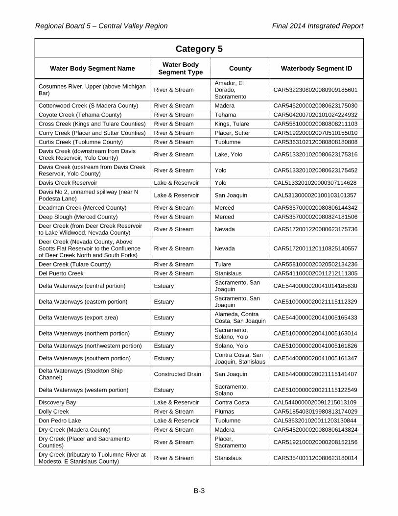
Regional Board 5 – Central Valley Region Final 2014 Integrated Report
B-3
Category 5
Water Body Segment Name Water Body Segment Type County Waterbody Segment ID
Cosumnes River, Upper (above Michigan Bar) River & Stream
Amador, El Dorado, Sacramento
CAR5322308020080909185601
Cottonwood Creek (S Madera County) River & Stream Madera CAR5452000020080623175030 Coyote Creek (Tehama County) River & Stream Tehama CAR5042007020101024224932 Cross Creek (Kings and Tulare Counties) River & Stream Kings, Tulare CAR5581000020080808211103 Curry Creek (Placer and Sutter Counties) River & Stream Placer, Sutter CAR5192200020070510155010 Curtis Creek (Tuolumne County) River & Stream Tuolumne CAR5363102120080808180808 Davis Creek (downstream from Davis Creek Reservoir, Yolo County) River & Stream Lake, Yolo CAR5133201020080623175316
Davis Creek (upstream from Davis Creek Reservoir, Yolo County) River & Stream Yolo CAR5133201020080623175452
Davis Creek Reservoir Lake & Reservoir Yolo CAL5133201020000307114628 Davis No 2, unnamed spillway (near N Podesta Lane) Lake & Reservoir San Joaquin CAL5313000020100103101357
Deadman Creek (Merced County) River & Stream Merced CAR5357000020080806144342 Deep Slough (Merced County) River & Stream Merced CAR5357000020080824181506 Deer Creek (from Deer Creek Reservoir to Lake Wildwood, Nevada County) River & Stream Nevada CAR5172001220080623175736
Deer Creek (Nevada County, Above Scotts Flat Reservoir to the Confluence of Deer Creek North and South Forks)
River & Stream Nevada CAR5172001120110825140557
Deer Creek (Tulare County) River & Stream Tulare CAR5581000020020502134236 Del Puerto Creek River & Stream Stanislaus CAR5411000020011212111305
Delta Waterways (central portion) Estuary Sacramento, San Joaquin CAE5440000020041014185830
Delta Waterways (eastern portion) Estuary Sacramento, San Joaquin CAE5100000020021115112329
Delta Waterways (export area) Estuary Alameda, Contra Costa, San Joaquin CAE5440000020041005165433
Delta Waterways (northern portion) Estuary Sacramento, Solano, Yolo CAE5100000020041005163014
Delta Waterways (northwestern portion) Estuary Solano, Yolo CAE5100000020041005161826
Delta Waterways (southern portion) Estuary Contra Costa, San Joaquin, Stanislaus CAE5440000020041005161347
Delta Waterways (Stockton Ship Channel) Constructed Drain San Joaquin CAE5440000020021115141407
Delta Waterways (western portion) Estuary Sacramento, Solano CAE5100000020021115122549
Discovery Bay Lake & Reservoir Contra Costa CAL5440000020091215013109 Dolly Creek River & Stream Plumas CAR5185403019980813174029 Don Pedro Lake Lake & Reservoir Tuolumne CAL5363201020011203130844 Dry Creek (Madera County) River & Stream Madera CAR5452000020080806143824 Dry Creek (Placer and Sacramento Counties) River & Stream Placer,
Sacramento CAR5192100020000208152156
Dry Creek (tributary to Tuolumne River at Modesto, E Stanislaus County) River & Stream Stanislaus CAR5354001120080623180014

Regional Board 5 – Central Valley Region Final 2014 Integrated Report
B-4
Category 5
Water Body Segment Name Water Body Segment Type County Waterbody Segment ID
Duck Creek (San Joaquin County) River & Stream San Joaquin, Stanislaus CAR5314000020080803214539
Duck Slough (Merced County) River & Stream Merced CAR5357000020080808202452 Dunn Creek (Mt Diablo Mine to Marsh Creek) River & Stream Contra Costa CAR5362000019980813174632
East Park Reservoir Lake & Reservoir Colusa CAL5223300020020418140610 Eastman Lake (Madera County) Lake & Reservoir Madera, Mariposa CAL5391200020111118152314 Eastman Lake (Shasta County) Lake & Reservoir Shasta CAL5264105320090114085030 Elbow Creek (from Mathews Ditch to Cottonwood Creek, Tulare County) River & Stream Tulare CAR5581000020070511151618
Elder Creek River & Stream Sacramento CAR5191100019980817124745 Elk Bayou (Tulare County) River & Stream Tulare CAR5581000020080808204645 Englebright Lake Lake & Reservoir Nevada, Yuba CAL5171401320020111103938 Fall River (Pit) River & Stream Shasta CAR5264103119980813175731 Fall River, tributary to Feather River, Middle Fork (Butte and Plumas Counties) River & Stream Butte, Plumas CAR5183206220080915143905
Feather River, Lower (Lake Oroville Dam to Confluence with Sacramento River) River & Stream Butte, Sutter, Yuba CAR5192200019980817161057
Feather River, Middle Fork (Sierra Valley to Lake Oroville, Butte and Plumas Counties)
River & Stream Plumas CAR5183305020020610143011
Feather River, North Fork (below Lake Almanor) River & Stream Butte, Plumas CAR5181200020020610144132
Feather River, South Fork (from Little Grass Valley Reservoir to Lake Oroville, Butte and Plumas Counties)
River & Stream Butte, Plumas CAR5181105020020502143718
Feather River, West Branch (from Griffin Gulch to Lake Oroville) River & Stream Butte CAR5186003120041214145753
Fingers Lake Lake & Reservoir Tehama CAL5042007020091215014035 Five Mile Slough (Alexandria Place to Fourteen Mile Slough; in Delta Waterways, eastern portion)
River & Stream San Joaquin CAR5440000019990127160243
Folsom Lake Lake & Reservoir El Dorado, Placer, Sacramento CAL5142301020080702152603
French Camp Slough (confluence of Littlejohns and Lone Tree Creeks to San Joaquin River, San Joaquin Co; partly in Delta Waterways, eastern portion)
River & Stream San Joaquin CAR5314000020020702142222
French Ravine River & Stream Nevada CAR5163201119990127161329 Freshwater Creek (Little Valley to Salt Creek, Colusa County) River & Stream Colusa CAR5613001020080623181554
Fresno River (Above Hensley Reservoir to confl w Nelder Creek and Lewis Fork) River & Stream Madera CAR5393103120050607101604
Fresno Slough (from Graham Road to James Bypass, Fresno County) River & Stream Fresno CAR5518000020080623182154
Gilsizer Slough (from Yuba City to downstream of Township Road, Sutter County)
River & Stream Sutter CAR5203000020080702172323
Gold Run (Nevada County) River & Stream Nevada CAR5172001220081113234051

Regional Board 5 – Central Valley Region Final 2014 Integrated Report
B-5
Category 5
Water Body Segment Name Water Body Segment Type County Waterbody Segment ID
Gordon Slough (from headwaters and Goodnow Slough to Adams Canal, Yolo County)
River & Stream Yolo CAR5113001220080702171951
Grant Line Canal subwatershed at Clifton Court Rd (San Joaquin County) River & Stream San Joaquin CAR5440000020101103103932
Grant Line Canal subwatershed near Calpack Rd (San Joaquin County) River & Stream San Joaquin CAR5440000020101103104525
Grasslands Marshes Wetland, Freshwater
Madera, Merced, Stanislaus CAW5412000019990127152712
Grayson Drain (at outfall) Constructed Drain Stanislaus CAR5411000020050919204400 Hamilton Slough (from south of Thermalito Afterbay to south of Biggs, Butte County)
River & Stream Butte CAR5204000020080702171637
Harding Drain Constructed Drain Stanislaus CAR5355000019980813181351 Hell Hole Reservoir Lake & Reservoir Placer CAL5144501320020418144044 Hensley Lake Lake & Reservoir Madera CAL5393201020020702142618 Hetch Hetchy Reservoir Lake & Reservoir Tuolumne CAL5366009120020418144307 Highline Canal (from Mustang Creek to Lateral No 8, Merced and Stanislaus Counties)
Constructed Drain Merced, Stanislaus CAR5356000020080707125417
Honcut Creek (Butte and Yuba Counties) River & Stream Butte, Yuba CAR5154000020080707105944 Horse Creek (Rising Star Mine to Shasta Lake) River & Stream Shasta CAR5062001019980814101128
Hospital Creek (San Joaquin and Stanislaus Counties) River & Stream San Joaquin,
Stanislaus CAR5411000020070511113812
Humbug Creek (Diggins Creek to Yuba River, South Fork) River & Stream Nevada CAR5173203019980814102308
Hume Lake Lake & Reservoir Fresno CAL5523428120020418144415 Indian Creek (from Antelope Lake to East Branch of North Fork Feather River, Plumas County)
River & Stream Plumas CAR5185304420080707104927
Indian Valley Reservoir (Lake County) Lake & Reservoir Lake CAL5134002020000209140532 Ingalsbe Slough (tributary to Merced River, Merced County) River & Stream Merced CAR5356000020080707130803
Ingram Creek (from confluence with Hospital Creek to Hwy 33 crossing) River & Stream Stanislaus CAR5411000020050920172409
Ingram Creek (from confluence with San Joaquin River to confluence with Hospital Creek)
River & Stream Stanislaus CAR5411000020011211113332
Isabella Lake Lake & Reservoir Kern CAL5542101020020418145333 Jack Slough River & Stream Yuba CAR5154000020011211114128 James Bypass (Fresno County) River & Stream Fresno CAR5512000020101114141001 James Creek River & Stream Napa CAR5122401019980814103109 Jawbone Creek, unnamed tributary (Tuolumne County) River & Stream Tuolumne CAR5364004020101020133452
Kanaka Creek River & Stream Sierra CAR5174202219980814103946 Kaseberg Creek (tributary to Pleasant Grove Creek, Placer County) River & Stream Placer CAR5192200020070510154406

Regional Board 5 – Central Valley Region Final 2014 Integrated Report
B-6
Category 5
Water Body Segment Name Water Body Segment Type County Waterbody Segment ID
Kaseberg Creek, unnamed eastern tributary (from Green Grove Ln to Del Webb Blvd)
River & Stream Placer CAR5192200020120321143734
Kaseberg Creek, unnamed southeastern tributary (from Silverado Middle School to Timber Creek Golf Course, Placer County)
River & Stream Placer CAR5192200020120321144035
Kaseberg Creek, unnamed southern tributary (from Baseline Road to Timber Creek Golf Course, Placer County)
River & Stream Placer CAR5192200020120323142726
Kaweah Lake Lake & Reservoir Tulare CAL5534401020020418150015 Kaweah River (below Terminus Dam, Tulare County) River & Stream Tulare CAR5581000020080707132829
Kaweah River, Lower (includes St Johns River) River & Stream Tulare CAR5581000020020627102603
Kellogg Creek (Los Vaqueros Reservoir to Discovery Bay; partly in Delta Waterways, western portion)
River & Stream Contra Costa CAR5430003120080707113548
Kentucky Creek (Nevada County) River & Stream Nevada CAR5173101320110209100523 Keswick Reservoir (portion downstream from Spring Creek) Lake & Reservoir Shasta CAL5244001220020730101915
Kings River, Lower (Island Weir to Stinson and Empire Weirs) River & Stream Fresno, Kings CAR5519000019990127164206
Kings River, Lower (Pine Flat Reservoir to Island Weir) River & Stream Fresno, Kings,
Tulare CAR5518000020090112105219
Knights Landing Ridge Cut (Yolo County) Constructed Drain Yolo CAR5202100020080708170311 Laguna Creek (tributary to Cosumnes River, Sacramento County) River & Stream Sacramento CAR5311100020101025223941
Langworth Pipeline (Stanislaus County) River & Stream Stanislaus CAR5353000020101114131730 Lassen Creek (Modoc County) River & Stream Modoc CAR5271002120101024215504 Little Backbone Creek, Lower River & Stream Shasta CAR5062001019980818101339 Little Cow Creek (downstream from Afterthought Mine) River & Stream Shasta CAR5073301019990126112551
Little Deer Creek River & Stream Nevada CAR5172001220011211134726 Little Grizzly Creek River & Stream Plumas CAR5185403119980814104512 Little Panoche Creek River & Stream Fresno, San Benito CAR5424104120000210155826
Littlejohns Creek River & Stream Calaveras, San Joaquin, Stanislaus CAR5314000020070511145114
Live Oak Slough River & Stream Sutter CAR5203000020070511150326
Lone Tree Creek River & Stream San Joaquin, Stanislaus CAR5314000019980814105503
Lone Willow Slough (Madera County) River & Stream Madera CAR5451000020080808203024 Loon Lake Lake & Reservoir El Dorado CAL5144401220091208154522 Los Banos Creek (below Los Banos Reservoir, Merced County) River & Stream Merced CAR5412000020080808200529
Los Banos Reservoir Lake & Reservoir Merced CAL5424200020000209140231 Los Gatos Creek (Fresno County) River & Stream Fresno CAR5511101120020628113523 Los Vaqueros Reservoir Lake & Reservoir Contra Costa CAL5430003020111216161902 Lower Blue Lake Lake & Reservoir Lake CAL5135402020091208155011

Regional Board 5 – Central Valley Region Final 2014 Integrated Report
B-7
Category 5
Water Body Segment Name Water Body Segment Type County Waterbody Segment ID
Main Drain (Kern County) River & Stream Kern CAR5587000020101114140120 Main Drainage Canal River & Stream Butte, Sutter CAR5204000020041130180509 Marsh Creek (Dunn Creek to Marsh Creek Reservoir) River & Stream Contra Costa CAR5430002320021209140332
Marsh Creek (Marsh Creek Reservoir to San Joaquin River; partly in Delta Waterways, western portion)
River & Stream Contra Costa CAR5430002019980814110539
Marsh Creek Reservoir Lake & Reservoir Contra Costa CAL5430002219980814120535 McClure Reservoir (Mariposa County) Lake & Reservoir Mariposa CAL5372200020020430110127 Meadows Slough (Sacramento County) Lake & Reservoir Sacramento CAL5100000020100103113105
Mendota Pool Wetland, Freshwater Fresno, Madera CAW5512000020021001113547
Merced River, Lower (McSwain Reservoir to San Joaquin River) River & Stream Merced, Stanislaus CAR5357000019980817154245
Merle Collins Lake Lake & Reservoir Yuba CAL5171303220020628145054 Middle River (in Delta Waterways, southern portion) River & Stream San Joaquin CAR5440000020021001092442
Mile Long Pond (Butte County) Lake & Reservoir Butte CAL5154000020080810182808 Miles Creek (Merced County) River & Stream Merced CAR5358000020080808201956 Mill Creek (Fresno County) River & Stream Fresno CAR5524004220101117135815 Mill Creek (Tehama County) River & Stream Tehama CAR5094203120020508115919 Mill Creek (Tulare County) River & Stream Kings, Tulare CAR5581000020081030155033 Millerton Lake Lake & Reservoir Fresno, Madera CAL5401200020020430134218 Miners Ravine (Placer County) River & Stream Placer CAR5142401020090105144715 Modesto Reservoir Lake & Reservoir Stanislaus CAL5354001120091208193024 Mokelumne River, Lower (in Delta Waterways, eastern portion) River & Stream Sacramento, San
Joaquin CAR5440000019980818095133
Moon Lake Lake & Reservoir Lassen CAL5265304120091208193713 Mormon Slough (Commerce Street to Stockton Deep Water Channel; partly in Delta Waterways, eastern portion)
River & Stream San Joaquin CAR5313000020000209130407
Mormon Slough (from Stockton Diverting Canal to Bellota Weir--Calaveras River) River & Stream San Joaquin CAR5313000020050622171527
Mormon Slough (Stockton Diverting Canal to Commerce Street) River & Stream San Joaquin CAR5313000020021209142456
Morrison Creek River & Stream Sacramento CAR5191100019980817123042 Mosher Slough (downstream of I-5; in Delta Waterways, eastern portion) River & Stream San Joaquin CAR5312000019990127153844
Mountain House Creek (from Altamont Pass to Old River, Alameda and San Joaquin Counties; partly in Delta Waterways, southern portion)
River & Stream Alameda, San Joaquin CAR5440000020080702173527
Mud Creek (Butte County) River & Stream Butte CAR5042007020080724092148 Mud Slough, North (downstream of San Luis Drain) River & Stream Merced CAR5412000020080820161412
Mud Slough, North (upstream of San Luis Drain) River & Stream Merced CAR5412000020080820163230
Mustang Creek (Merced County) River & Stream Merced CAR5356000020080808193633

Regional Board 5 – Central Valley Region Final 2014 Integrated Report
B-8
Category 5
Water Body Segment Name Water Body Segment Type County Waterbody Segment ID
Natoma, Lake Lake & Reservoir Sacramento CAL5192100020020430135321 Natomas Cross Canal (Sutter County) Constructed Drain Sutter CAR5192200020080731222408 Natomas East Main Drainage Canal (aka Steelhead Creek, downstream of confluence with Arcade Creek)
River & Stream Sacramento CAR5192100020021209150207
Natomas East Main Drainage Canal (aka Steelhead Creek, upstream of confluence with Arcade Creek)
River & Stream Placer, Sacramento, Sutter CAR5192100019980817101740
New Bullards Bar Reservoir Lake & Reservoir Yuba CAL5175101120020418111348 New Hogan Lake (Calaveras County) Lake & Reservoir Calaveras CAL5331001120080810181802
New Melones Reservoir Lake & Reservoir Calaveras, Tuolumne CAL5342101020020430113521
Newman Wasteway Constructed Drain Merced, Stanislaus CAR5412000020011211151440 Niagara Creek (Tuolumne County) River & Stream Tuolumne CAR5343001020150624053105 North Canyon Creek (El Dorado County) River & Stream El Dorado CAR5143202420080808191510 Oak Run Creek River & Stream Shasta CAR5073300020011212121326 Old River (San Joaquin River to Delta-Mendota Canal; in Delta Waterways, southern portion)
River & Stream San Joaquin CAR5440000020021001091129
ONeill Forebay Lake & Reservoir Merced CAL5423103220000209134612 Oregon Creek (Yuba and Sierra Counties) River & Stream Nevada, Sierra,
Yuba CAR5174101220110209095856
Orestimba Creek (above Kilburn Road) River & Stream Stanislaus CAR5422003219990126113826 Orestimba Creek (below Kilburn Road) River & Stream Stanislaus CAR5355000020021209154446 Oroville Wildlife Area Fishing Pond (Butte County) Lake & Reservoir Butte CAL5154000020080810191013
Oroville, Lake Lake & Reservoir Butte CAL5181200020020430135809 Outside Creek (Tulare County) River & Stream Tulare CAR5581000020080820134604 Oxbow Reservoir (Ralston Afterbay, El Dorado and Placer Counties) Lake & Reservoir El Dorado, Placer CAL5144101020080922153913
Pacific Heights Pond, Lower (Butte County) Lake & Reservoir Butte CAL5154000020080810191305
Packwood Creek (Tulare County) River & Stream Tulare CAR5581000020080808203922 Panoche Creek (Silver Creek to Belmont Avenue) River & Stream Fresno CAR5591106019990126154446
Pardee Reservoir Lake & Reservoir Amador, Calaveras CAL5326009120000208163748 Pine Creek (Butte County) River & Stream Butte CAR5042007020080724091506 Pine Flat Reservoir Lake & Reservoir Fresno CAL5523201020020430145454 Pit River (from confluence of N and S forks to Shasta Lake) River & Stream Lassen, Modoc,
Shasta CAR5266108019990126150509
Pit River, North Fork River & Stream Modoc CAR5265201620080909193959 Pit River, South Fork River & Stream Lassen, Modoc CAR5265208020080909194359 Pixley Slough (San Joaquin County; partly in Delta Waterways, eastern portion)
River & Stream San Joaquin CAR5312000020080803212723
Pleasant Grove Creek River & Stream Placer, Sutter CAR5192200020070510150258 Pleasant Grove Creek, South Branch River & Stream Placer CAR5192200020070510153551

Regional Board 5 – Central Valley Region Final 2014 Integrated Report
B-9
Category 5
Water Body Segment Name Water Body Segment Type County Waterbody Segment ID
Pleasant Grove Creek, South Branch, unnamed southeastern trib (from east of Sierra View Country Club to confl with Pleasant Grove Cr, South Branch)
River & Stream Placer CAR5192200020120321144543
Pleasant Grove Creek, unnamed northern tributary (from Greywood Circle to confluence with Pleasant Grove Creek)
River & Stream Placer CAR5192200020120323141359
Pleasant Grove Creek, unnamed northern tributary (from Mt Tamalpais Dr to confluence with Pleasant Grove Creek)
River & Stream Placer CAR5192200020120321144312
Poorman Creek (Nevada County) River & Stream Nevada CAR5173201020110209161450 Poso Slough Constructed Drain Fresno, Merced CAR5412000020070511112656 Potato Slough, Little (San Joaquin County) River & Stream San Joaquin CAR5440000020101103102717
Putah Creek (Solano Lake to Putah Creek Sinks; partly in Delta Waterways, northwestern portion)
River & Stream Napa, Solano, Yolo CAR5112000020000208170214
Ramona Lake Lake & Reservoir Stanislaus CAL5411000020101114234044 Ramona Lake (Fresno County) Lake & Reservoir Fresno CAL5404001820080810192411 Rattlesnake Creek (at confluence w Mokelumne River, N Fork) River & Stream Amador CAR5326005020041214084636
Robinsons Riffle Pond (Butte County) Lake & Reservoir Butte CAL5154000020080810185534 Rock Creek (Nevada County) River & Stream Nevada CAR5173203320110209161055 Rock Creek (Placer County) River & Stream Placer CAR5142201120090105143038 Rollins Reservoir Lake & Reservoir Nevada, Placer CAL5163403320011212084035 Rose Creek (Tuolumne County) River & Stream Tuolumne CAR5342201020101020155327 Rush Creek (Modoc County) River & Stream Modoc CAR5266403120090105142803 Sacramento River (Keswick Dam to Cottonwood Creek) River & Stream Shasta, Tehama CAR5081000019990126144739
Sacramento River ( Cottonwood Creek to Red Bluff) River & Stream Tehama CAR5042007020021209153351
Sacramento River ( Red Bluff to Knights Landing) River & Stream Butte, Glenn,
Tehama CAR5201000019990126140752
Sacramento River (Knights Landing to the Delta) River & Stream Sutter, Yolo CAR5100000020021210114330
Sacramento Slough River & Stream Sutter CAR5192200019980814113208 Salado Creek (Stanislaus County) River & Stream Stanislaus CAR5421003120080808192723 Salt Slough (Mud Slough to Sand Dam, Merced County) Constructed Drain Merced CAR5412000020101114233142
Salt Slough (upstream from confluence with San Joaquin River) Constructed Drain Merced CAR5412000019990126155034
San Carlos Creek (downstream of New Idria Mine) River & Stream San Benito CAR5591108519980814113911
San Joaquin River ( Mendota Pool to Bear Creek) River & Stream Madera, Merced,
Stanislaus CAR5357000019990126152905
San Joaquin River (Bear Creek to Mud Slough) River & Stream Merced CAR5357000020021002093226

Regional Board 5 – Central Valley Region Final 2014 Integrated Report
B-10
Category 5
Water Body Segment Name Water Body Segment Type County Waterbody Segment ID
San Joaquin River ( Mud Slough to Merced River) River & Stream Merced, Stanislaus CAR5357000020021002094621
San Joaquin River ( Merced River to Tuolumne River) River & Stream Merced, Stanislaus CAR5440000020021002100850
San Joaquin River ( Tuolumne River to Stanislaus River) River & Stream San Joaquin,
Stanislaus CAR5353000020041020143854
San Joaquin River (Friant Dam to Mendota Pool) River & Stream Fresno, Madera CAR5453001020050602140817
San Joaquin River (Stanislaus River to Delta Boundary) River & Stream San Joaquin CAR5440000020041020140348
San Luis Reservoir Lake & Reservoir Merced CAL5423201020020430153652 Sand Creek (Colusa County) River & Stream Colusa CAR5202100020070511143646 Sand Creek (tributary to Marsh Creek, Contra Costa County; partly in Delta Waterways, western portion)
River & Stream Contra Costa CAR5430001120080808191800
Scotchman Creek (Nevada County) River & Stream Nevada CAR5173202020110209160757 Scotts Flat Reservoir Lake & Reservoir Nevada CAL5172001120011212085852 Shady Creek (Nevada County) River & Stream Nevada CAR5173101220110209094927 Shasta Lake Lake & Reservoir Shasta CAL5061000020080922152749 Shasta Lake (area where West Squaw Creek enters) Lake & Reservoir Shasta CAL5061000020020730101829
Simmerly Slough (Yuba County) River & Stream Yuba CAR5154000020080731221221 Siskiyou, Lake Lake & Reservoir Siskiyou CAL5252202220020501142027 Slab Creek Reservoir (El Dorado County) Lake & Reservoir El Dorado CAL5143201320080922153345 Smith Canal (in Delta Waterways, eastern portion) River & Stream San Joaquin CAR5440000020011212090303
Snake River (Butte and Sutter Counties) River & Stream Butte, Sutter CAR5203000020101024221451 Solano, Lake Lake & Reservoir Solano, Yolo CAL5112000020020501144846 South Cow Creek River & Stream Shasta CAR5073100020011212122645 Spanish Creek (Plumas County) River & Stream Plumas CAR5185101120020701110401 Spring Creek (Colusa County) River & Stream Colusa CAR5612002020070510165737 Spring Creek (Nevada County) River & Stream Nevada CAR5173203120110209094624 Spring Creek, Lower (Iron Mountain Mine to Keswick Reservoir) River & Stream Shasta CAR5244001019980818103919
Squirrel Creek (Nevada County) River & Stream Nevada CAR5172002320080731223725
Stanislaus River, Lower River & Stream Calaveras, Stanislaus, Tuolumne
CAR5353000019980817151834
Stone Corral Creek River & Stream Colusa CAR5613003020070511135450 Stony Creek River & Stream Glenn, Tehama CAR5202100020020701133119 Stony Gorge Reservoir Lake & Reservoir Glenn CAL5222200020000209112836 Strong Ranch Slough River & Stream Sacramento CAR5192100019980817095051 Success Lake Lake & Reservoir Tulare CAL5551205820020520110057 Sucker Run (Butte County) River & Stream Butte CAR5182202320080731220413 Sullivan Creek (from Phoenix Reservoir to Don Pedro Lake, Tuolumne County) River & Stream Tuolumne CAR5363102220080808181306
Sulphur Creek (Colusa County) River & Stream Colusa CAR5132002420021209115923

Regional Board 5 – Central Valley Region Final 2014 Integrated Report
B-11
Category 5
Water Body Segment Name Water Body Segment Type County Waterbody Segment ID
Sutter Bypass Constructed Drain Sutter CAR5203000020000210152322 Sweany Creek (Solano County) River & Stream Solano CAR5111000020110225100244 Sycamore Slough (Yolo County) River & Stream Colusa, Yolo CAR5201000020081113232951 Temple Creek River & Stream San Joaquin CAR5314000019990127162616 Thermalito Afterbay Lake & Reservoir Butte CAL5154000020000209142817 Thermalito Forebay Lake & Reservoir Butte CAL5154000020000209143205 Tom Paine Slough (in Delta Waterways, southern portion) River & Stream San Joaquin CAR5440000020080803215847
Town Creek River & Stream Shasta CAR5062001019980818104951 Tule Canal (Yolo County) Constructed Drain Yolo CAR5112000020080731222809 Tule River, Lower River & Stream Kings, Tulare CAR5581000020020701150855
Tulloch Reservoir Lake & Reservoir Calaveras, Tuolumne CAL5342206320020501145743
Tuolumne River, Lower (Don Pedro Reservoir to San Joaquin River) River & Stream Stanislaus,
Tuolumne CAR5355000019980817143435
Turlock Lake Lake & Reservoir Stanislaus CAL5356000020091208202721 Turnback Creek (Tuolumne County) River & Stream Tuolumne CAR5363103020101203154356 Turner Slough (drains into San Joaquin River (Bear Creek to Mud Slough), Merced County)
River & Stream Merced CAR5412000020101114231648
Turner Slough (Merced County) River & Stream Merced CAR5357000020080703103135 Twain Harte Creek (Tuolumne County) River & Stream Tuolumne CAR5363101020101020200841 Ulatis Creek (Solano County) River & Stream Solano CAR5601001220080801154307 Wadsworth Canal Constructed Drain Sutter CAR5203000020041130173733 Walker Creek (Glenn County) River & Stream Glenn CAR5202100020101024220320 West Squaw Creek (below Balaklala Mine) River & Stream Shasta CAR5062004219980818112334
West Valley Reservoir Lake & Reservoir Lassen, Modoc CAL5265304520020501150007 Westley Wasteway (Stanislaus County) Constructed Drain Stanislaus CAR5411000020080808192151 Whiskeytown Lake Lake & Reservoir Shasta CAL5246100020090110151054 Whiskeytown Lake (areas near Oak Bottom, Brandy Creek Campgrounds and Whiskeytown)
Lake & Reservoir Shasta CAL5246100019980814123354
Wildwood, Lake (Nevada County) Lake & Reservoir Nevada CAL5172002020080810191901 Willow Creek (Lassen County, Central Valley) River & Stream Lassen, Modoc CAR5266107220090110153757
Willow Creek (Madera County) River & Stream Madera CAR5402105120000216112815 Willow Creek (Shasta County, below Greenhorn Mine to Clear Creek) River & Stream Shasta CAR5246301119980818110732
Willow Slough (Yolo County) River & Stream Yolo CAR5112000020080801153727 Willow Slough Bypass (Yolo County) River & Stream Yolo CAR5112000020080801152942 Wolf Creek (Nevada County) River & Stream Nevada CAR5163201020011212113551 Woods Creek (Tuolumne County) River & Stream Tuolumne CAR5363104120080808175556 Woodward Reservoir Lake & Reservoir Stanislaus CAL5354001120091208203448 Yankee Slough (Placer and Sutter Counties) River & Stream Placer, Sutter CAR5151000020080731221832

Regional Board 5 – Central Valley Region Final 2014 Integrated Report
B-12
Category 5
Water Body Segment Name Water Body Segment Type County Waterbody Segment ID
Yuba River (confluence of North and Middle Yuba Rivers to Englebright Lake) River & Stream Nevada, Sierra,
Yuba CAR5174102220020702105502
Yuba River, Lower River & Stream Yuba CAR5153000020020702135622
Yuba River, North Fork River & Stream Nevada, Sierra, Yuba CAR5175101120020702103628
Yuba River, South Fork (Headwaters to Spaulding, Lake) River & Stream Nevada, Placer CAR5173401020110207094836
Yuba River, South Fork (Spaulding Reservoir to Englebright Reservoir) River & Stream Nevada, Placer CAR5173203120020710160332
Zayak (Swan) Lake Lake & Reservoir Nevada CAL5162001020111221115959

Regional Board 5 – Central Valley Region Final 2014 Integrated Report
C-1
APPENDIX C: CATEGORY 4a WATER BODY SEGMENTS Category 4a Criteria: A waterbody segment where ALL its 303(d) listings are being addressed AND at least one of those listings is being addressed by a USEPA-approved TMDL.
Category 4a
Water Body Segment Name Water Body Segment Type County Waterbody Segment ID
Bear Creek (Colusa County) River & Stream Colusa CAR5132002320011128111020
Cache Creek, North Fork (below Indian Valley Reservoir, Lake County) River & Stream Lake CAR5134004020080731215753
Clear Lake Lake & Reservoir Lake CAL5135200019980814115549
Duck Slough (in Delta Waterways, northern portion) River & Stream Solano, Yolo CAR5100000020080623183037
Elk Grove Creek River & Stream Sacramento CAR5191100019980817130203
Harley Gulch River & Stream Lake CAR5133202219980814100614
Mosher Slough (upstream of I-5; partly in Delta Waterways, eastern portion) River & Stream San Joaquin CAR5440000020021209144512
Walker Slough (partly in Delta Waterways, eastern portion) River & Stream San Joaquin CAR5314000020020111134652

Regional Board 5 – Central Valley Region Final 2014 Integrated Report
D-1
APPENDIX D: CATEGORY 4b WATER BODY SEGMENTS Category 4b Criteria: A waterbody segment where ALL its 303(d) listings are being addressed by regulatory program(s) other than a TMDL.
Category 4b
Water Body Segment Name Water Body Segment Type County Waterbody Segment ID
Morrison Slough River & Stream Butte, Sutter CAR5203000020070511132905
Winters Canal (Yolo County) Constructed Drain Yolo CAR5112000020080801150313
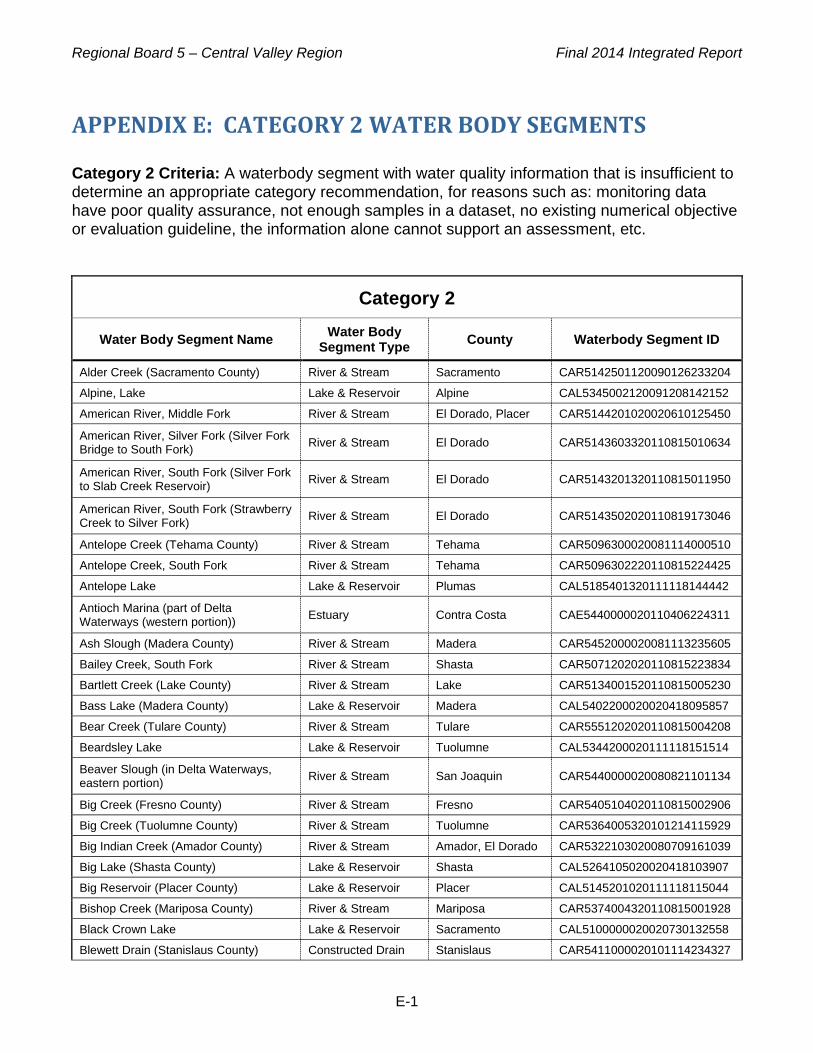
Regional Board 5 – Central Valley Region Final 2014 Integrated Report
E-1
APPENDIX E: CATEGORY 2 WATER BODY SEGMENTS Category 2 Criteria: A waterbody segment with water quality information that is insufficient to determine an appropriate category recommendation, for reasons such as: monitoring data have poor quality assurance, not enough samples in a dataset, no existing numerical objective or evaluation guideline, the information alone cannot support an assessment, etc.
Category 2
Water Body Segment Name Water Body Segment Type County Waterbody Segment ID
Alder Creek (Sacramento County) River & Stream Sacramento CAR5142501120090126233204
Alpine, Lake Lake & Reservoir Alpine CAL5345002120091208142152
American River, Middle Fork River & Stream El Dorado, Placer CAR5144201020020610125450
American River, Silver Fork (Silver Fork Bridge to South Fork) River & Stream El Dorado CAR5143603320110815010634
American River, South Fork (Silver Fork to Slab Creek Reservoir) River & Stream El Dorado CAR5143201320110815011950
American River, South Fork (Strawberry Creek to Silver Fork) River & Stream El Dorado CAR5143502020110819173046
Antelope Creek (Tehama County) River & Stream Tehama CAR5096300020081114000510
Antelope Creek, South Fork River & Stream Tehama CAR5096302220110815224425
Antelope Lake Lake & Reservoir Plumas CAL5185401320111118144442
Antioch Marina (part of Delta Waterways (western portion)) Estuary Contra Costa CAE5440000020110406224311
Ash Slough (Madera County) River & Stream Madera CAR5452000020081113235605
Bailey Creek, South Fork River & Stream Shasta CAR5071202020110815223834
Bartlett Creek (Lake County) River & Stream Lake CAR5134001520110815005230
Bass Lake (Madera County) Lake & Reservoir Madera CAL5402200020020418095857
Bear Creek (Tulare County) River & Stream Tulare CAR5551202020110815004208
Beardsley Lake Lake & Reservoir Tuolumne CAL5344200020111118151514
Beaver Slough (in Delta Waterways, eastern portion) River & Stream San Joaquin CAR5440000020080821101134
Big Creek (Fresno County) River & Stream Fresno CAR5405104020110815002906
Big Creek (Tuolumne County) River & Stream Tuolumne CAR5364005320101214115929
Big Indian Creek (Amador County) River & Stream Amador, El Dorado CAR5322103020080709161039
Big Lake (Shasta County) Lake & Reservoir Shasta CAL5264105020020418103907
Big Reservoir (Placer County) Lake & Reservoir Placer CAL5145201020111118115044
Bishop Creek (Mariposa County) River & Stream Mariposa CAR5374004320110815001928
Black Crown Lake Lake & Reservoir Sacramento CAL5100000020020730132558
Blewett Drain (Stanislaus County) Constructed Drain Stanislaus CAR5411000020101114234327

Regional Board 5 – Central Valley Region Final 2014 Integrated Report
E-2
Category 2
Water Body Segment Name Water Body Segment Type County Waterbody Segment ID
Blue Creek (below Blue Lake Dam to confluence w Deer Creek) River & Stream Alpine CAR5326001620041214080622
Blue Lake, Upper (Alpine County) Lake & Reservoir Alpine CAL5326001620111118151139 Blue Lakes (Lake County) Lake & Reservoir Lake CAL5135402020111118114910 Bourland Creek (Tuolumne County) River & Stream Tuolumne CAR5364002320101020160322
Bowman Lake Lake & Reservoir Nevada CAL5173301120111118120209 Brite Valley Lake Lake & Reservoir Kern CAL5562002020111216152637 Brush Creek (El Dorado County) River & Stream El Dorado CAR5143201220110815001045
Bucks Lake Lake & Reservoir Plumas CAL5184201120020418105030
Bunch Creek (Placer County) River & Stream Placer CAR5145101020080823141843
Butt Creek (below Keefer Ranch to Lake Almanor) River & Stream Plumas CAR5184304320041209125000
Butte Lake Lake & Reservoir Lassen CAL5263601120111118145313 Cache Creek, North Fork, unnamed tributary River & Stream Lake CAR5134002020110815225056
Calaveras River, Lower (from New Hogan Reservoir to Bellota Weir)
Coastal & Bay Shoreline
Calaveras, San Luis Obispo, Stanislaus CAR5313000020090428173756
Calaveras River, North Fork (Calaveras County) River & Stream Calaveras CAR5332004020080801170743
Calaveritas Creek (Calaveras County) River & Stream Calaveras CAR5333004220080808173644
Capell Creek (from headwaters to Lake Berryessa, Napa County) River & Stream Napa CAR5122201220080623172042
Caples Lake Lake & Reservoir Alpine CAL5143601020091208114206
Carson Creek (El Dorado County) River & Stream El Dorado CAR5322201320110814235632 Carson Creek (from WWTP to Deer Creek) River & Stream El Dorado,
Sacramento CAR5322201320041109091641
Castac Lake Lake & Reservoir Kern CAL5563006320091208115141 Castle Creek, Lower (Nevada County) River & Stream Nevada CAR5173401020110209161912
Castle Lake Lake & Reservoir Siskiyou CAL5252202220111118144841
Cave Lake Lake & Reservoir Modoc CAL5271001020111118150431
Cherokee Canal Constructed Drain Butte CAR5204000020041130175907
Chips Creek River & Stream Plumas CAR5184301120110814235245 Chowchilla River (Above Eastman Lake to confl w Chowchilla East and West Forks)
River & Stream Madera, Mariposa CAR5391103120050607100913
Chowchilla River (below Eastman Lake) River & Stream Madera, Mariposa, Merced CAR5357000020020610134523
Chowchilla River, East Fork (Confl w Chowchilla River to Headwaters) River & Stream Madera, Mariposa CAR5391102020050608184906
Chowchilla River, Middle Fork (Confl with Chowchilla River West Fork to Headwaters)
River & Stream Madera, Mariposa CAR5391103020050608185345
Chowchilla River, West Fork (Confl w Chowchilla River to Headwaters) River & Stream Madera, Mariposa CAR5391101020050608185703

Regional Board 5 – Central Valley Region Final 2014 Integrated Report
E-3
Category 2
Water Body Segment Name Water Body Segment Type County Waterbody Segment ID
Churn Creek River & Stream Shasta CAR5081000020000208134137
Cirby Creek River & Stream Placer CAR5192100020110814234946
Clover Creek (Shasta County) River & Stream Shasta CAR5081000020110814234504
Coarse Gold Creek River & Stream Madera CAR5393105120080824170944 Comanche Creek (from Little Chico Creek to Angel Slough, Butte and Glenn Counties)
River & Stream Butte, Glenn CAR5204000020080623163527
Contra Loma Reservoir Lake & Reservoir Contra Costa CAL5440000020000217082907 Cosumnes River, North Fork River & Stream El Dorado CAR5322308020110822171824
Cottonwood Creek River & Stream Shasta, Tehama CAR5082000020000208151646 Cottonwood Creek, unnamed tributary at Cottonwood Meadow (Tuolumne County)
River & Stream Tuolumne CAR5365107020101020130014
Courtright Reservoir Lake & Reservoir Fresno CAL5523302120111118152956
Cow Creek (above Little Cow Creek) River & Stream Shasta CAR5081000020020610140318
Cow Creek (Tuolumne County) River & Stream Tuolumne CAR5344105020101028161426
Coyote Creek (Calaveras County) River & Stream Calaveras CAR5342203020120423143823
Crooks Creek River & Stream Madera CAR5393103220080824171429
Curtis Creek unnamed tributary (Tuolumne County) River & Stream Tuolumne CAR5363102020101214114836
Davis Lake (Plumas County) Lake & Reservoir Plumas CAL5183401020020418135013
Deer Creek (Sacramento County) River & Stream El Dorado, Sacramento CAR5322201220020625110936
Deer Creek (Tehama County) River & Stream Tehama CAR5092004220110820075549
Del Puerto Canyon (Stanislaus County) River & Stream Stanislaus CAR5421002220080824184045
Diggins Creek (Nevada County) River & Stream Nevada CAR5173203020110315132233
Dry Creek (Sacramento and San Joaquin Counties; partly in Delta Waterways, eastern portion)
River & Stream Sacramento, San Joaquin CAR5312000020080803152639
Dry Creek (tributary to Clear Creek, Butte County) River & Stream Butte CAR5204000020090330141413
Dry Creek (Yuba County) River & Stream Yuba CAR5171201020110209101140
Duncan Reservoir Lake & Reservoir Modoc CAL5265101320111118145823
Dye Creek River & Stream Tehama CAR5096201120110811032520
Egg Lake Slough River & Stream Lassen, Modoc CAR5266108020110814224600
El Nido Canal (Merced County) Constructed Drain Merced CAR5357000020101101104142 Elbow Creek, unnamed tributary below Sheep Meadow (Alpine County) River & Stream Alpine CAR5326001020101020153836
Elder Creek (at Gerber) River & Stream Tehama CAR5042007020000216112211
Faucherie Lake Lake & Reservoir Nevada CAL5173301020111118120339
Feather River, East Branch North Fork (Plumas County) River & Stream Plumas CAR5185103020020618103810
Feather River, South Branch Middle River & Stream Butte, Plumas CAR5183207020110814225159

Regional Board 5 – Central Valley Region Final 2014 Integrated Report
E-4
Category 2
Water Body Segment Name Water Body Segment Type County Waterbody Segment ID
Fork
Feeley Lake Lake & Reservoir Nevada CAL5173403120091208115725
Fitzhugh Creek, Lower (Modoc County) River & Stream Modoc CAR5265204220090113145748
Flea Valley Creek River & Stream Butte CAR5184205120050722160237
Florence Lake Lake & Reservoir Fresno CAL5404002220091208120152
French Creek River & Stream Butte CAR5181101320110814224236
Frenchman Lake Lake & Reservoir Plumas CAL5183601120020418143059
Fresno River (below Hensley Reservoir) River & Stream Madera, Merced CAR5451000020000208153356
Fuller Lake Lake & Reservoir Nevada CAL5173403020091208120438 Garrote Creek (called First Garrote Creek), unnamed tributary (Tuolumne County)
River & Stream Tuolumne CAR5364005320110106171925
Garrote Creek (called Second Garrote Creek), unnamed tributary (Tuolumne County)
River & Stream Tuolumne CAR5363103120110324155603
Gold Lake Lake & Reservoir Sierra CAL5183303220091208120837
Goodrich Creek (Lassen County) River & Stream Lassen CAR5184504020090114083849 Grand Island Drain, south of confluence w west, middle, east forks, Sacramento County)
Constructed Drain Sacramento CAR5100000020101025232352
Grasshopper Slough (Yuba County) River & Stream Yuba CAR5151000020101025225428
Grizzly Creek (Madera County) River & Stream Madera CAR5374001320110815230706
Grizzly Creek (Plumas County) River & Stream Plumas CAR5184204020110815230307
Hangtown Creek (El Dorado County) River & Stream El Dorado CAR5143102120081114001020
Hat Creek River & Stream Shasta CAR5263104120020618105513
Hatch Drain (Stanislaus County) Constructed Drain Stanislaus CAR5355000020101024130902
Herring Creek, unnamed tributary (Tuolumne County) River & Stream Tuolumne CAR5343001220101028160300
Highland Creek River & Stream Lake CAR5135503120000216111839
Howard Drain (Merced County) Constructed Drain Merced CAR5358000020101024125202
Hulbert Creek (Modoc County) River & Stream Modoc CAR5266302120090108165316
Huntington Lake Lake & Reservoir Fresno CAL5405200020111118152651
Ice House Reservoir Lake & Reservoir El Dorado CAL5143302020020418144833
Indian Creek (headwaters to Antelope Lake, Plumas County) River & Stream Plumas CAR5185304420020502151300
Iron Canyon Reservoir Lake & Reservoir Shasta CAL5261503020020418145140
Jackson Meadows Reservoir Lake & Reservoir Nevada, Sierra CAL5174301220020418145717
Jacobson Drain (Stanislaus County) Constructed Drain Stanislaus CAR5353000020101115133829
Jamison Creek (Plumas County) River & Stream Plumas CAR5183304020090114083509
Jawbone Creek (Tuolumne County) River & Stream Tuolumne CAR5364004020110207143809
Jones Drain (Merced County) Constructed Drain Merced CAR5358000020101025161543
Jones Fork Silver Creek River & Stream El Dorado CAR5143401020110811034757

Regional Board 5 – Central Valley Region Final 2014 Integrated Report
E-5
Category 2
Water Body Segment Name Water Body Segment Type County Waterbody Segment ID
Kaweah River, East Fork (Confl w Kaweah River to Confl w Horse Creek) River & Stream Tulare CAR5534105220050608154929
Kaweah River, Marble Fork (Confl w Kaweah River Middle Fork to Marble Falls)
River & Stream Tulare CAR5534104320050608175336
Kaweah River, Middle Fork (Confl w Kaweah River East Fork to Dome Creek)
River & Stream Tulare CAR5534302320050608154640
Kaweah River, South Fork (Confl w Kaweah River to Fork Drive) River & Stream Tulare CAR5534201120050608180820
Kelso Creek (Kern County) River & Stream Kern CAR5542204120110815230039
Kern River, South Fork River & Stream Kern CAR5542203020110811033149
Kidd Lake Lake & Reservoir Placer CAL5173401120091208121143
Kings River, Middle Fork (Confl w Main Fork to confl w Silver Creek) River & Stream Fresno CAR5523415120050608155615
Kings River, South Fork (Bubbs Creek to Grizzly Creek) River & Stream Fresno CAR5523424320110815233208
Kings River, South Fork (Confl w Main Fork to confl w Grizzly Creek) River & Stream Fresno CAR5523426220050608155812
Kings River, South Fork (Woods Creek to Bubbs Creek) River & Stream Fresno CAR5523422020110820072657
La Grange Reservoir Lake & Reservoir Stanislaus, Tuolumne CAL5362000020091208141412
Lake Of The Pines Lake & Reservoir Nevada CAL5163301220100103103814
Last Chance Creek (Plumas County) River & Stream Plumas CAR5185505020090114083149
Lateral Drain 1 (Stanislaus County) Constructed Drain Stanislaus CAR5353000020101114125013
Lateral Drain 11 (San Joaquin County) Constructed Drain San Joaquin CAR5351000020101114133844
Lateral Drain 12 (San Joaquin County) Constructed Drain San Joaquin CAR5351000020101114133535
Lateral Drain 14 (San Joaquin County) Constructed Drain San Joaquin CAR5314000020101114133140
Lateral Drain 2 1/2 (Stanislaus County) Constructed Drain Stanislaus CAR5355000020101024132634
Lateral Drain 3 (Stanislaus County) Constructed Drain Stanislaus CAR5353000020101114124749
Lateral Drain 5 (Stanislaus County) Constructed Drain Stanislaus CAR5353000020101114124402
Lateral Drain 5 1/2 (Stanislaus County) Constructed Drain Stanislaus CAR5355000020101103142042
Lateral Drain 6 (Stanislaus County) Constructed Drain Stanislaus CAR5353000020101114124146
Lateral Drain 7 (Stanislaus County) Constructed Drain Stanislaus CAR5353000020101114123912
Lewis Creek (Fresno County) River & Stream Fresno CAR5523424320090108165046
Lights Creek (Plumas County) River & Stream Plumas CAR5185303120090114081316
Lily Lake Lake & Reservoir Modoc CAL5271001020111118150639
Lincoln Creek (Sierra County) River & Stream Sierra CAR5175401020110820072319
Linda Creek River & Stream Placer, Sacramento CAR5192100020000216105326
Lindo Channel River & Stream Butte CAR5042007020041130180143
Little Butte Slough River & Stream Butte, Glenn CAR5204000020110811031656

Regional Board 5 – Central Valley Region Final 2014 Integrated Report
E-6
Category 2
Water Body Segment Name Water Body Segment Type County Waterbody Segment ID
Little Chico Creek (Butte County) River & Stream Butte CAR5212001220090330140628
Little Grass Valley Reservoir Lake & Reservoir Plumas CAL5182401120020418150739
Livingston Canal (Merced County) Constructed Drain Merced CAR5358000020101101103802
Livingston Drain (Merced County) Constructed Drain Merced CAR5358000020101024123744
Long Meadow Creek River & Stream Fresno CAR5523428120110820072118
Lower Bucks Lake Lake & Reservoir Plumas CAL5184201120091208191331
Lucas Creek River & Stream Kern CAR5541004620110820071959
Magpie Creek River & Stream Sacramento CAR5192100020110819170251
Main Drain (Stanislaus County) Constructed Drain Stanislaus CAR5353000020101114123602
Mammoth Pool Reservoir Lake & Reservoir Fresno, Madera CAL5404006220020430105313
Mariposa Creek (Mariposa and Merced Counties) River & Stream Mariposa, Merced CAR5380006220101117154615
McCloud River River & Stream Shasta, Siskiyou CAR5062001020020502153921
McCumber Reservoir Lake & Reservoir Shasta CAL5071202320020430104948
McGaugh Slough (Lake County) River & Stream Lake CAR5135503320080731215315 McSwain Lake Lake & Reservoir Mariposa CAL5371001220020628143949 Medicine Lake Lake & Reservoir Siskiyou CAL5264201020111118150059 Miami Creek (Madera and Mariposa Counties) River & Stream Madera, Mariposa CAR5393102020090108164716
Mill Creek (Butte County) River & Stream Butte CAR5184205120050722155911
Mill Creek (Kern County) River & Stream Kern CAR5541004320110820071749
Mill Flat Creek River & Stream Fresno CAR5523416720110820071513
Mokelumne River, South Fork River & Stream Calaveras CAR5326009020080801165352
Mootz Drain (Stanislaus County) Constructed Drain Stanislaus CAR5353000020101024123358
Mormon Creek (Tuolumne County) River & Stream Tuolumne CAR5342204320101203155115
Morris Ravine (tributary to Thermalito Diversion Pool, Butte County) River & Stream Butte CAR5154000020080731220719
Murphy Slough (from Kings River to Fresno Slough, Fresno County) River & Stream Fresno CAR5518000020080808195331
Nelder Creek (Madera County) River & Stream Madera CAR5393101120090105144343
North Side Canal (Merced County) Constructed Drain Merced CAR5356000020101101101141
Obanion Outfall Drain (Sutter County) Constructed Drain Sutter CAR5203000020101221181921
Old Alamo Creek (Solano County) River & Stream Solano CAR5111000020090108165859
Owens Creek (Merced County) River & Stream Merced CAR5358000020080808201532
Paddy Creek (San Joaquin County) River & Stream San Joaquin CAR5312000020080803153900
Paradise Cut (in Delta Waterways, southern portion) River & Stream San Joaquin CAR5440000020080803215239
Paradise Reservoir Lake & Reservoir Butte CAL5213002420000209094439 Parsnip Creek River & Stream Lassen CAR5265304320110820071124
Peppermint Creek (Tuolumne County) River & Stream Tuolumne CAR5363104120101214102305

Regional Board 5 – Central Valley Region Final 2014 Integrated Report
E-7
Category 2
Water Body Segment Name Water Body Segment Type County Waterbody Segment ID
Peterson Creek (Madera and Mariposa Counties) River & Stream Madera, Mariposa CAR5393102220090105144146
Pinecrest Lake Lake & Reservoir Tuolumne CAL5343001120091208195207
Plum Creek River & Stream Tehama CAR5096400020110820070855
Pope Creek (Napa County) River & Stream Napa CAR5122401220080801145647
Porter Slough (Tulare County) River & Stream Tulare CAR5581000020080808205022
Potato Slough (in Delta Waterways, central portion) River & Stream San Joaquin CAR5440000020080820172643
Prairie Flower Drain (Stanislaus County) Constructed Drain Stanislaus CAR5355000020101024122138
Reclamation Drain (Merced County) Constructed Drain Merced CAR5355000020101024121417
Red Clover Creek (Plumas County) River & Stream Plumas CAR5185402220090105143946
Reservoir C (Modoc County) Lake & Reservoir Modoc CAL5265106020111118145607
Rice Creek, North Arm River & Stream Plumas, Shasta CAR5184401020110814223846
Roberts Island Tract Drain, at Holt Rd (San Joaquin County) Constructed Drain San Joaquin CAR5440000020101103101311
Roberts Island Tract Drain, at House Rd (San Joaquin County) Constructed Drain San Joaquin CAR5440000020101103100950
Rock Creek (tributary to Spanish Creek, Plumas County) River & Stream Plumas CAR5185201420090105143338
Russell Ave Drain (Fresno County) Constructed Drain Fresno CAR5412000020101115120553
Sacramento City Marina (part of Delta Waterways (northern portion)) Estuary Sacramento CAE5191100020110406221233
Sacramento River (Above Shasta Lake) River & Stream Shasta, Siskiyou CAR5252203320000209092549
Salt Creek, Middle River & Stream Shasta CAR5062002020110811033541
San Joaquin River (below Mammoth Pool Reservoir to Millerton Lake) River & Stream Fresno, Madera CAR5404006220050608153747
San Joaquin River at Westside Irrigation District Pumps (Stanislaus County)
River & Stream Stanislaus CAR5411000020101114232839
Sand Slough (Merced County) River & Stream Merced CAR5357000020080806145124 Santa Rita Slough (from San Joaquin River to Wood Slough, Fresno and Merced Counties)
River & Stream Fresno, Merced CAR5412000020080703103919
Sayles Canyon Creek River & Stream El Dorado CAR5143501320110814220954
Secret Ravine (Placer County) River & Stream Plumas CAR5142401020090108163257
Secret Ravine, unnamed tributary River & Stream Placer CAR5142401020110822174149
Silva Drain (Merced County) Constructed Drain Merced CAR5358000020101025160519
Silver Lake (Amador County) Lake & Reservoir Amador CAL5143601320111118115759
Sonora Creek (Tuolumne County) River & Stream Tuolumne CAR5363104120101214120249
South Slough (Merced County) River & Stream Merced CAR5357000020080808194058 South Webb Tract Drain (Contra Costa County) Constructed Drain Contra Costa CAR5440000020101102162443

Regional Board 5 – Central Valley Region Final 2014 Integrated Report
E-8
Category 2
Water Body Segment Name Water Body Segment Type County Waterbody Segment ID
Spaulding, Lake Lake & Reservoir Nevada CAL5173403020020501143845
Spenker Drain (Stanislaus County) Constructed Drain Stanislaus CAR5353000020101114123100
Spicer Meadow Reservoir Lake & Reservoir Tuolumne CAL5345001320111118151655 Stanislaus River Drain (San Joaquin County) River & Stream San Joaquin CAR5440000020101103100732
Stanislaus River, Upper (New Melones Res to Tulloch Res) River & Stream Calaveras,
Tuolumne CAR5342206320020701114625
Steamboat Slough (in Delta Waterways, northern portion) River & Stream Sacramento,
Solano CAR5100000020080820234435
Stone Corral Irrigation Drain (Tulare County) Constructed Drain Tulare CAR5581000020110104113349
Stumpy Meadows Reservoir Lake & Reservoir El Dorado CAL5144304020091208202105
Sugar Pine Creek (tributary to Lower Bear River Reservoir) River & Stream Amador CAR5326004320041214084907
Sugarloaf Creek River & Stream Shasta CAR5062001020110811033914
Sullivan Creek, unnamed tributary near Brentwood Lake (Tuolumne County) River & Stream Tuolumne CAR5363101020110208120632
Sullivan Creek, unnamed tributary near Buena Vista Avenida (Tuolumne County)
River & Stream Tuolumne CAR5363101020110208115956
Sullivan Creek, unnamed tributary near Longeway Rd (Tuolumne County) River & Stream Tuolumne CAR5363101020101214101523
Sulphur Creek (Plumas and Sierra Counties) River & Stream Plumas, Sierra CAR5183302120090108162726
Sweet Lateral Drain (San Joaquin County) Constructed Drain San Joaquin CAR5352000020101114125556
Ten Mile Creek (Kings River, South Fork) River & Stream Fresno, Tulare CAR5523428220020702144647
Tenaya Creek River & Stream Mariposa CAR5376003120110814220649
Terminous Tract Drain, at Hwy 12 (San Joaquin County) Constructed Drain San Joaquin CAR5440000020101103110608
Thermalito Diversion Pool Lake & Reservoir Butte CAL5187001020041214114430
Tiger Creek (above Tiger Creek Regulator Reservoir) River & Stream Amador CAR5326006320110814220208
Tiger Creek (below Tiger Creek Regulator Reservoir to Mokelumne River, N Fork)
River & Stream Amador CAR5326006320041214082401
Toe Drain (in Delta Waterways, northwestern portion) River & Stream Solano, Yolo CAR5100000020080821000818
Tule River, Middle Fork (below confluence of North and South forks of the Middle Fork)
River & Stream Tulare CAR5551204120090325115104
Tule River, Upper (below confluence of North and Middle forks to Success Lake)
River & Stream Tulare CAR5551206120090325115511
Tuolumne River, South Fork River & Stream Tuolumne CAR5368002120110814223454

Regional Board 5 – Central Valley Region Final 2014 Integrated Report
E-9
Category 2
Water Body Segment Name Water Body Segment Type County Waterbody Segment ID
Tuolumne River, Upper (Don Pedro Res to Hetch Hetchy Reservoir) River & Stream Tuolumne CAR5364005020050607100139
Tunnel Reservoir Lake & Reservoir Shasta CAL5261502220091208202510
Twain Harte Lake Lake & Reservoir Tuolumne CAL5363101020110814221427
Union Valley Reservoir Lake & Reservoir El Dorado CAL5143403120020501145912 Village West Marina (part of Delta Waterways (eastern portion) Estuary San Joaquin CAE5440000020110406223035
Walthall Slough (in Delta Waterways, eastern portion) River & Stream San Joaquin CAR5440000020080818111435
Washington Creek (Modoc County) River & Stream Modoc CAR5266302220090113144723 Waterford Lateral Main Drain (Stanislaus County) Constructed Drain Stanislaus CAR5353000020101115132847
Webb, Lake Lake & Reservoir Kern CAL5571000020111216165202
Weber Creek (El Dorado County) River & Stream El Dorado CAR5143206020090107213613
Westport Drain (Stanislaus County) Constructed Drain Stanislaus CAR5355000020101024120417
White Pines Lake Lake & Reservoir Calaveras CAL5333001020091215010234
White River (Tulare County) River & Stream Tulare CAR5581000020080808205754
White Rock Creek (El Dorado County) River & Stream El Dorado CAR5143203220090107212314
Willow Creek (Modoc County) River & Stream Modoc CAR5271001320101024214851
Willow Creek (Sacramento County) River & Stream Sacramento CAR5142501120090107211344
Wishon Reservoir Lake & Reservoir Fresno CAL5523305220020501150516
Wolf Creek (Plumas County) River & Stream Plumas CAR5185305020090112103601
Z Drain (Yolo County) Constructed Drain Yolo CAR5100000020101028094010

Regional Board 5 – Central Valley Region Final 2014 Integrated Report
F-1
APPENDIX F: CATEGORY 1 WATER BODY SEGMENTS Category 1 Criteria: A waterbody segment that fully supports at least one of its California beneficial uses, has other uses that are not assessed or lack sufficient information to be assessed, and no assessed uses are known to be impaired.
Category 1
Water Body Segment Name Water Body Segment Type County Waterbody Segment ID
Antelope Creek (Placer County) River & Stream Placer CAR5142401020080822214143
Auburn Ravine River & Stream Placer CAR5142202120080823110505
Barker Slough (Solano County, in Delta Waterways, northwestern portion) River & Stream Solano CAR5100000020110922101705
Blue Lake, Lower (Alpine County) Lake & Reservoir Alpine CAL5326001620081113233333
Burney Creek River & Stream Shasta CAR5263101220020228151619 Butt Valley Reservoir (Plumas County) Lake & Reservoir Plumas CAL5184302220041209123701
Cache Slough (in Delta Waterways, northern and northwestern portions) River & Stream Sacramento,
Solano CAR5100000020080821102031
Cottonwood Creek (Tehama County) River & Stream Tehama CAR5096300020110814224828
Deer Creek (Yuba County) River & Stream Nevada, Yuba CAR5171201420021125141605
East Creek, Upper (Modoc and Lassen Counties) River & Stream Lassen, Modoc CAR5265301020090113145217
Fiddle Creek (Sierra County) River & Stream Sierra CAR5175303220110209100727
French Meadows Reservoir Lake & Reservoir Placer CAL5144201220020418142948
Glen Creek (from Kelly Ridge to Glen Pond, Butte County) River & Stream Alameda, Alpine,
Amador, Butte CAR5187001020041214113800
Glen Pond Lake & Reservoir Butte CAL5187001020080702161031
Greenhorn Creek (Nevada Co) River & Stream Nevada CAR5163403020041122154107
Gumboot Lake Lake & Reservoir Siskiyou CAL5252201020091208120944
Hilmar Drain (Merced County) Constructed Drain Merced CAR5355000020101024130145
Jenkinson Lake (El Dorado County) Lake & Reservoir El Dorado CAL5322305020000216105913
Kaweah River, Upper (from North Fork to Kaweah Lake) River & Stream Tulare CAR5534107120020627094115
Kern River, Lower River & Stream Kern CAR5589001220020627111118
Kern River, North Fork River & Stream Kern, Tulare CAR5542407720020627141254
Kings River, Upper North Fork River & Stream Fresno CAR5523416720020628110747
Lavezzola Creek (Sierra County) River & Stream Sierra CAR5175301220110209100234
Lewis Fork (Madera County) River & Stream Madera CAR5393101020090108145534 Logan Creek (Glenn and Colusa Counties) River & Stream Colusa, Glenn CAR5202100020101024224548
Lower Bear River Reservoir Lake & Reservoir Amador CAL5326004320020430103904

Regional Board 5 – Central Valley Region Final 2014 Integrated Report
F-2
Category 1
Water Body Segment Name Water Body Segment Type County Waterbody Segment ID
Lurline Creek (Colusa County) River & Stream Colusa CAR5613002120101024223514
Marshall Road Drain (Stanislaus County) Constructed Drain Stanislaus CAR5411000020110215153941
Meadow Creek (below Meadow Lake Dam to Mokelumne River, N Fork) River & Stream Alpine CAR5326001420041214080941
Merced River, Upper River & Stream Mariposa CAR5373006120020716114140
Middle Creek (Lake County) River & Stream Lake CAR5135404020101028113308
Mill River (Modoc County) River & Stream Modoc CAR5265302420090108164326
Mokelumne River, Middle Fork River & Stream Calaveras CAR5326007020080808172929
Mokelumne River, North Fork River & Stream Alpine, Amador, Calaveras CAR5326001420041208150818
Mokelumne River, Upper River & Stream Amador, Calaveras CAR5326009020000208160319
North Battle Creek Reservoir Lake & Reservoir Shasta CAL5071201020111118114508
North Forebay Creek (tributary to Thermalito Forebay, Butte County) River & Stream Butte CAR5154000020080731220948
Pacific Heights Pond, Upper (Butte County) Lake & Reservoir Butte CAL5154000020080810191505
Reed Creek, unnamed tributary (Tuolumne County) River & Stream Tuolumne CAR5364003020110217151233
Rush Creek (Nevada County) River & Stream Nevada CAR5173101120110209095418
San Antonio Creek (Calaveras County) River & Stream Calaveras CAR5333004020080808174806
Shag Slough (in Delta Waterways, northwestern portion) River & Stream Solano, Yolo CAR5100000020080820173715
Sullivan Creek (above Phoenix Reservoir, Tuolumne County) River & Stream Tuolumne CAR5363101020101203154751
Sutter Creek (tributary to Dry Creek, Amador County) River & Stream Amador CAR5311100020080801155330
Thoms Creek (Modoc County) River & Stream Modoc CAR5265201520090108162222
Yosemite Lake Lake & Reservoir San Joaquin CAL5440000020091208203712

Regional Board 5 – Central Valley Region Final 2014 Integrated Report
H-1
APPENDIX H: MISCELLANEOUS CHANGES REPORT
Region Water Body Name Water Body ID Water Body Type Change Type Change Information
5
Bear River, Upper from combie lake to Camp Far West Reservoir (Nevada and Placer Counties)
CAR5163301020011128161810 River & Stream
Water body name modification
Water body name updated from Bear River, Upper to Bear River, Upper from Combie Lake to Camp Far West Reser-voir (Nevada and Placer Counties)
5 Ulatis Creek CAR5601001220080801154307 River & Stream Update
The mapped representation of the water body was extended to represent new data received this cycle
5 Whiskeytown Lake CAL5246100020090110151054 Lake & Reservoir Update
The mapped representation of the water body was extended to represent new data received this cycle
5 Black Crown Lake CAL5100000020020730132558
Lake & Reservoir
Water body name modification
Water body name updated from Beach Lake to Black Crown Lake
5 Humbug Creek (Diggins Creek to Yuba River, South Fork)
CAR5173203019980814102308 River & Stream
Water body name modification
Water body name updated from Humbug Creek to Humbug Creek (Diggins Creek to Yuba River, South Fork)
5 Rock Creek (tributary to Spanish Creek, Plumas County)
CAR5185201420090105143338 River & Stream
Water body name modification
Water body name updated from Rock Creek (Plumas County) to Rock Creek (Tributary to Spanish Creek, Plumas County)
5
Yuba River (confluence of North and Middle Yuba Rivers to Englebright Lake)
CAR5174102220020702105502 River & Stream
Water body name modification
Water body name updated from Yuba River, Middle Fork to Yuba River (conflu-ence of North and Middle Yuba River to Englebright Lake)

Regional Board 5 – Central Valley Region Final 2014 Integrated Report
J-1
APPENDIX J: DELTA WATERWAYS Figure 1 in this appendix illustrates the geographic extent of the eight Delta portion areas, Figures 2 through 10 show the (numbered) waterways within each Delta portion, and Table 1 lists the individual waterway names, by Delta portion, which correspond with the numbered waterways in the maps.

Regional Board 5 – Central Valley Region Final 2014 Integrated Report
J-2

Regional Board 5 – Central Valley Region Final 2014 Integrated Report
J-3
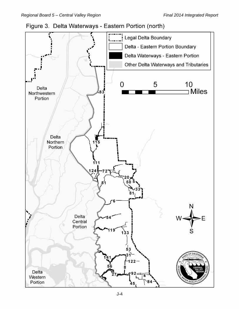
Regional Board 5 – Central Valley Region Final 2014 Integrated Report
J-4

Regional Board 5 – Central Valley Region Final 2014 Integrated Report
J-5

Regional Board 5 – Central Valley Region Final 2014 Integrated Report
J-6

Regional Board 5 – Central Valley Region Final 2014 Integrated Report
J-7

Regional Board 5 – Central Valley Region Final 2014 Integrated Report
J-8

Regional Board 5 – Central Valley Region Final 2014 Integrated Report
J-9

Regional Board 5 – Central Valley Region Final 2014 Integrated Report
J-10
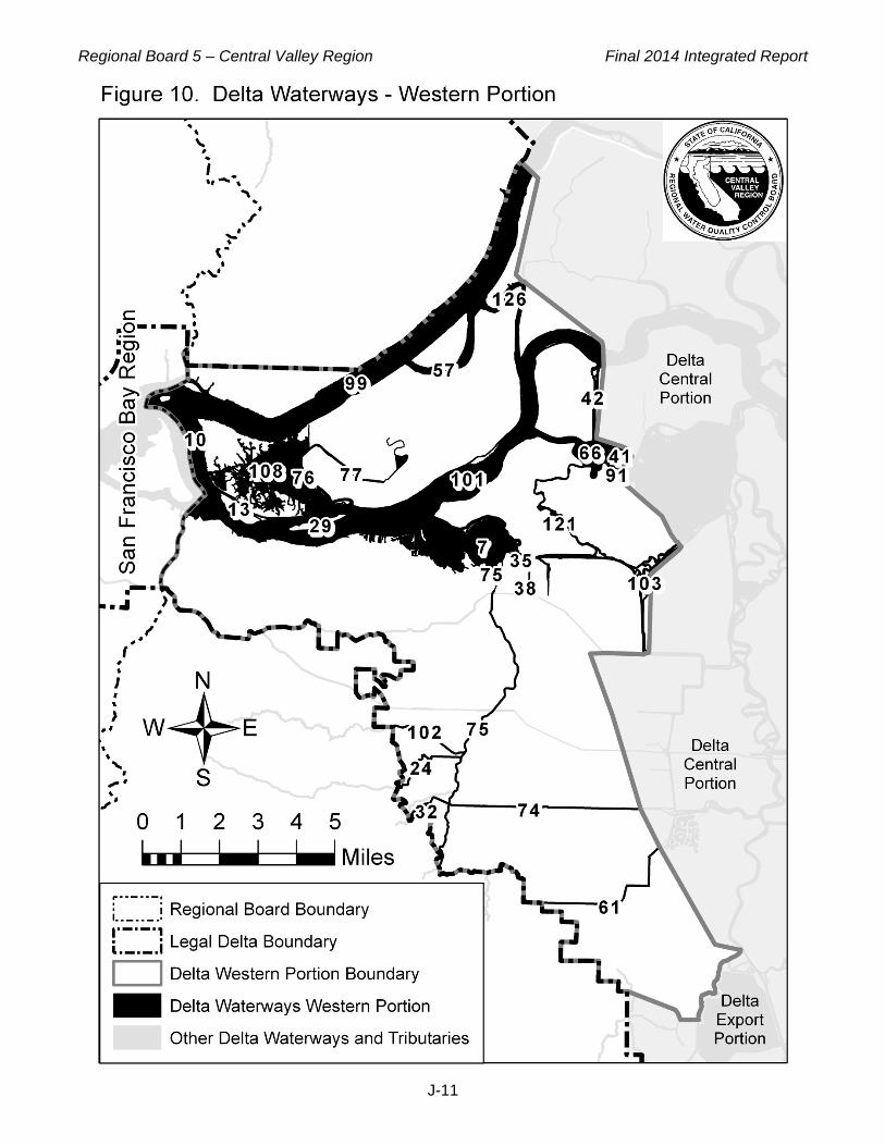
Regional Board 5 – Central Valley Region Final 2014 Integrated Report
J-11

Regional Board 5 – Central Valley Region Final 2014 Integrated Report
J-12
Table 1: Individual waterway names by Delta portion,
which correspond with the numbered waterways in Figures 2 through 10.
Delta Waterways - Central Portion
(Figure 2) Water Body Name ID #
Black Slough 9 Columbia Cut 18 Connection Slough 19 Dead Dog Slough 22 Dead Horse Cut 23 Delta Cross Channel 25 Discovery Bay 28 Empire Cut 39 False River 41 Franks Tract 46 Georgiana Slough 48 Holland Cut 55 Indian Slough 58 Jackson Slough 60 Latham Slough 62 Little Connection Slough 65 Little Mandeville Cut 67 Little Potato Slough 68 Little Venice Island 147 Main Canal 74 Middle River 78 Mildred Island 79 Mokelumne River 81 North Fork Mokelumne River 87 Old River 89 Piper Slough 91 Potato Slough 93 Rhode Island 96 Rock Slough 97 San Joaquin River 101 Sand Mound Slough 103 Santa Fe Cut 104 Sevenmile Slough 105 Sheep Slough 107 Short Slough 109 Snodgrass Slough 111 South Fork Mokelumne River 112 Three River Reach 125

Regional Board 5 – Central Valley Region Final 2014 Integrated Report
J-13
Delta Waterways - Central Portion (Figure 2)
Water Body Name ID # Tomato Slough 129 Trapper Slough 130 Turner Cut 131 Washington Cut 137 Werner Dredger Cut 138 Whiskey Slough 140 Woodward & North Victoria Canals 88 / 143
Delta Waterways - Eastern Portions (Figures 3 & 4)
Water Body Name ID # Bear Creek 4 Bear Slough 5 Beaver Slough 6 Bishop Cut 8 Calaveras River 15 Cosumnes River 20 Disappointment Slough 27 Dredger Cut 31 Dry Creek 33 Fivemile Creek 44 Fivemile Slough 44 Fourteenmile Slough 45 French Camp Slough 47 Grizzly Slough 50 Highline Canal 53 Hog Slough 54 Honker Cut 56 Lost Slough 72 Mokelumne River 81 Mormon Slough 82 Morrison Creek 83 Mosher Slough 84 Pixley Slough 92 Red Bridge Slough 95 Smith Canal 110 Snodgrass Slough 111 Stone Lakes 115 Sycamore Slough 119

Regional Board 5 – Central Valley Region Final 2014 Integrated Report
J-14
Delta Waterways - Eastern Portions (Figures 3 & 4)
Water Body Name ID # Telephone Cut 122 The Meadows Slough 124 Upland Canal (Sycamore Slough tributary) 133 Walker Slough 135 Walthall Slough 136 White Slough 141 Yosemite Lake 145
Delta Waterways – Export Area (Figure 5)
Water Body Name ID # Brushy Creek 11 Clifton Court Forebay 17 Italian Slough 59 Old River 89 West Canal 139
Delta Waterways – Northern Portion (Figure 6)
Water Body Name ID # Babel Slough 2 Cache Slough 14 Duck Slough 34 Elk Slough 36 Elkhorn Slough 37 Main Canal 73 Miner Slough 80 Sacramento Deep Water Channel 98 Sacramento River 99 Steamboat Slough 113 Sutter Slough 117 Taylor Slough 120 Winchester Lake 142

Regional Board 5 – Central Valley Region Final 2014 Integrated Report
J-15
Delta Waterways – Northwestern Portion (Figure 7)
Water Body Name ID # Barker Slough 3 Cache Slough 14 Calhoun Cut 16 Duck Slough 34 Haas Slough 51 Hastings Cut 52 Liberty Cut 63 Lindsey Slough 64 Lookout Slough 71 Prospect Slough 94 Shag Slough 106 Sweany Creek 118 Sycamore Slough 119 The Big Ditch 123 Toe Drain 127 Ulatis Creek 132 Wright Cut 144
Delta Waterways – Southern Portion (Figure 8)
Water Body Name ID # Burns Cutoff 12 Crocker Cut 21 Deuel Drain 26 Doughty Cut 30 Grant Line Canal 49 Livermore Yacht Club 70 Middle River 78 Mountain House Creek 85 Old River 89 Paradise Cut 90 Salmon Slough 100 San Joaquin River 101 Sugar Cut 116 Tom Paine Slough 128 Victoria & North Canals 86 / 134 Walthall Slough 136

Regional Board 5 – Central Valley Region Final 2014 Integrated Report
J-16
Delta Waterways – Stockton Ship Channel (Figure 9)
Water Body Name ID # Stockton Deep Water Channel 114
Delta Waterways – Western Portion (Figure 10)
Water Body Name ID # Big Break 7 Broad Slough 10 Cabin Slough 13 Deer Creek (tributary to Marsh Creek) 24 Donlon Island 29 Dutch Slough 35 Emerson Slough 38 False River 41 Fisherman's Cut 42 Horseshoe Bend 57 Kellogg Creek 61 Little Franks Tract 66 Main Canal 74 Marsh Creek 75 Mayberry Cut 76 Mayberry Slough 77 Piper Slough 91 Sacramento River 99 San Joaquin River 101 Sand Creek 102 Sand Mound Slough 103 Sherman Lake 108 Taylor Slough (near Franks Tract) 121 Threemile Slough 126

Regional Board 5 – Central Valley Region Final 2014 Integrated Report
K-1
APPENDIX K: RESPONSE TO COMMENTS
Contents Introduction ……………………………………………………………………………………………………….2
Responses to General Comments ........................................................................................................ 7 Data and Information from After the Solicitation Period .................................................................... 7 Consideration of pH and Dissolved Oxygen Cycling ......................................................................... 8
Section A: Responses to Oral Comments Provided During the Public Workshop on 14 October 2016 ................................................................................................................. 9
Shasta County Board of Supervisors – Pam Giacomini (Shasta County) ............................................ 9
Somach Simmons & Dunn – Tess Dunham (Somach Simmons & Dunn) .......................................... 10
San Joaquin Drainage Authority – David Corey (SJDA) ..................................................................... 10
Section B: Responses to Written Comment Letters Focused on Creeks in or near the Stanislaus National Forest .............................................................................................. 12
Section B.1: Responses to Written Comments on Issues Identified by More than One Commenter .................................................................................................................................. 12
General Comment 1: Stakeholders not notified of project; more public meetings needed. ............ 14 General Comment 2: Grazing is not the only bacteria source. ....................................................... 14 General Comment 3: Listings will have significant impact on both private and public stakeholders including the greater community. ............................................................................... 15 General Comment 4: Assessments only include data collected prior to August 2010; creek listings should be delayed until newer data that indicate different impairment story can be included in the assessments. .......................................................................................................... 16 General Comment 5: Assessments incorporated only one data source. ....................................... 17 General Comment 6: Potential for data bias due to data collector bias. ........................................ 17 General Comment 7: Timing and location of sample collection are not representative of overall water quality conditions. .................................................................................................................. 18 General Comment 8: Assessment effort should be coordinated with the new UC-stakeholder partnership convened to address grazing-related impairments. ...................................................... 19 General Comment 9: Water Contact Recreation is not the appropriate beneficial use to assess because these are small ephemeral creeks with limited swimming areas. ..................................... 20 General Comment 10: Appropriate standards, risk assessment and outreach are needed. .......... 21
Section B.2: Responses to Specific Written Comments on Issues Identified by Only One Commenter .................................................................................................................................. 22
William and Mary Crook Family (Crook Family) Letter Dated 20 October 2016 .............................. 22 William and Mary Crook Family (Crook Family) Email Dated 20 October 2016 .............................. 25 United States Forest Service Stanislaus National Forest (USFS SNF) ........................................... 26 Steven Wooster (Wooster) .............................................................................................................. 30 Central Sierra Environmental Resource Center (CSERC) .............................................................. 34

Regional Board 5 – Central Valley Region Final 2014 Integrated Report
K-2
Section C: Responses to All Other Written Comment Letters ....................................................... 37
Central Valley Clean Water Association (CVCWA) ......................................................................... 37 City of Brentwood (Brentwood) ........................................................................................................ 49 City of Stockton (Stockton) .............................................................................................................. 57 Earth Law Center & California Sportfishing Protection Alliance (ELC & CSPA) .............................. 60 Fresno Metropolitan Flood Control District (FMFCD) ...................................................................... 70 Pacific Gas and Electric Company (PG&E) ..................................................................................... 72 Somach Simmons & Dunn for Pyrethroid Working Group (SSD-PWG) .......................................... 76 Sacramento Stormwater Quality Partnership (SSQP) ..................................................................... 86 Sacramento Valley Water Quality Coalition (SVWQC) .................................................................... 88 San Joaquin Valley Drainage Authority for Westside San Joaquin River Watershed Coalition (WSJRWC) ....................................................................................................................... 90
Introduction This appendix presents Central Valley Water Board staff responses to comments received on the September 2016 draft Integrated Report during the public comment period, which extended from 19 September 2016 to 20 October 2016. This introduction summarizes the comments received, changes made to the proposed 303(d) List in response to comments, and general staff responses to issues that were brought up multiple times. The remainder of the appendix is organized into three sections. Section A addresses oral comments provided during the Board’s October 2016 public workshop, Section B addresses comments submitted in 15 letters that focused exclusively on water quality conditions and data assessments for creeks on or near grazing allotments in or near the Stanislaus National Forest, and Section C focuses on all other written comments. In some cases comments are paraphrased for brevity. Staff responses follow each comment in indented text. The full comment letters are available at http://www.waterboards.ca.gov/centralvalley/water_issues/tmdl/impaired_waters_list/index.shtml Table K-1 identifies the entities who provided oral and written comments and the appendix section that provides responses to their comments. Table K-2 provides a summary of changes to the proposed 303(d) List (Appendix A) and Category Reports (Appendices B through F) made in response to comments. Appendix L provides a summary of all changes to the assessment fact sheets, including changes that did not result in changes to the 303(d) List. These changes are described in more detail in the responses to comments in Sections B and C of this appendix.

Regional Board 5 – Central Valley Region Final 2014 Integrated Report
K-3
Table K-1: Entities who provided oral and written comments and the appendix section(s) that provides responses to their comments
Organization Name, Title (Submittal Date)
Workshop Oral
Comments (Section A)
Written Comments: Stanislaus
National Forest Creeks
(Section B)
Written Comments:
All Other Topics
(Section C)
Brennan Ranch Bob and Sherri Brennan (10/19/2016) X
Calaveras County Department of Agriculture (a) Kevin Wright, Ag Commissioner (10/18/2016) X
California Farm Bureau Federation Kari E. Fisher, Associate Counsel (10/20/2016) X
Central Sierra Environmental Resource Center John Buckley, Executive Director (10/20/2016) X
Central Valley Clean Water Association (b) Jenny Bayley, Project Engineer, Larry Walker Associates
(10/20/2016) Debbie Webster, Executive Officer (10/20/2016)
X
City of Brentwood Miki Tsubota, Director of Public Works/City Engineer
(10/20/2016) X
Earth Law Center & California Sportfishing Protection Alliance (joint letter, 10/19/2016)
Linda Sheehan, Executive Director, ELC William Jennings, Executive Director, CSPA
X
Eloise Fischer (10/17/2016) X
Fresno Metropolitan Flood Control District Daniel Rourke, Environmental Resources Manager
(10/19/2016) X
Pacific Gas & Electric Company Carrell Gill, Director, Hydro Licensing (10/20/2016) X
Pyrethroid Working Group Theresa A. Dunham (10/20/2016) X
Sacramento Stormwater Quality Partnership (10/20/2016) Dana Booth, Program Manager – Storm Water Quality,
Sacramento County Department of Water Resources Sherill Hunn, Supervising Engineer, City of Sacramento Department of Utilities
X
Sacramento Valley Water Quality Coalition Bruce Houdesheldt (10/20/2016) X
San Joaquin Valley Drainage Authority David Cory, Attorney (10/14/2016)
X
Shasta County Board of Supervisors Pam Giacomini, Supervisor, District 3 (10/14/2016) X

Regional Board 5 – Central Valley Region Final 2014 Integrated Report
K-4
Table K-1: Entities who provided oral and written comments and the appendix section(s) that provides responses to their comments
Organization Name, Title (Submittal Date)
Workshop Oral
Comments (Section A)
Written Comments: Stanislaus
National Forest Creeks
(Section B)
Written Comments:
All Other Topics
(Section C)
Somach Simmons & Dunn, on behalf of the Pyrethroid Working Group
Tess Dunham, Attorney (10/14/2016) X
Steven Wooster (10/19/2016) X
Stockton Permittees (10/20/2016) Ba T. Than, Deputy Director, Maintenance & Collections,
City of Stockton Brandon Nakagawa, Water Resources Manager, County of San Joaquin
X
Tuolumne County Alliance for Resources & Environment Melinda Fleming, Executive Director (10/20/2016) X
Tuolumne County Board of Supervisors Karl Rodefer, Chairman (10/18/2016) X
Tuolumne County Farm Bureau Shaun Crook, President (10/19/2016) X
U.S. Forest Service Jeanne M. Higgins, Forest Supervisor (10/20/2016) X
University of California Cooperative Extension Central Sierra Scott Oneto, Farm Advisor (10/17/2016) X
University of California, Davis John Miles, Professor Emeritus (10/19/2016) X
Westside San Joaquin River Watershed Coalition Joseph C. McGahan, Watershed Coordinator
(10/20/2016) X
William and Mary Crook Family Andrew W. Crook (10/20/2016) (1) Letter (2) Email with additional comments
X
(a) Kevin Wright submitted two emails with comments on behalf of the Calaveras County Department of Agriculture on 18 October 2016. The second email was identical to the first email with one exception: for clarification, the second email included a list of 303(d)-listed water bodies to which the comments applied. This appendix includes only the second email.
(b) Jenny Bayley and Debbie Webster both submitted comments on behalf of the Central Valley Clean Water Association. Though they provided slightly different introductory material, the comment tables submitted by each were identical. Consequently, Central Valley Water Board staff provided one set of responses to their comments.

Regional Board 5 – Central Valley Region Final 2014 Integrated Report
K-5
Table K-2: Summary of changes to the proposed 303(d) List (Appendix A) and Category Reports (Appendices B through F) made in response to public comments
Commenter and Comment # Water Body Segment Constituent Change Made
City of Brentwood Comments 1–6
Marsh Creek (Marsh Creek Reservoir to San Joaquin River; partly in Delta Waterways, western portion)
Bifenthrin Removed from the proposed 303(d) List.
Central Valley Clean Water Association Comment 9-11
Delta Waterways (southern portion)
Aluminum, Iron,
Manganese
Removed from the proposed 303(d) List.
Central Valley Clean Water Association Comment 13
Elk Bayou (Tulare County) Ammonia as N, total
Removed from the proposed 303(d) List.
Central Valley Clean Water Association Comment 18
Kings River, Lower (Pine Flat Reservoir to Island Weir)
Ammonia as N, Total
Removed from the proposed 303(d) List.
Central Valley Clean Water Association Comment 21
Main Drain (Kern County) Ammonia as N, Total
Removed from the proposed 303(d) List.
Central Valley Clean Water Association Comment 23
Mill Creek (Fresno County) Alkalinity as CaCO3
Removed from the proposed 303(d) List.
Central Valley Clean Water Association Comment 24
Mill Creek (Fresno County) Ammonia as N, Total
Removed from the proposed 303(d) List.
Central Valley Clean Water Association Comment 27
Old River (San Joaquin River to Delta-Mendota Canal; in Delta Waterways, southern portion):
Aluminum, Iron,
Manganese
Removed from the proposed 303(d) List.
Central Valley Clean Water Association Comment 29
Old River (San Joaquin River to Delta-Mendota Canal; in Delta Waterways, southern portion)
Lead Removed from the proposed 303(d) List.
General Comment #2 for Stanislaus NF creeks
Stanislaus National Forest creeks
Indicator Bacteria
Updated the decision fact sheets to include “natural sources” and “source unknown” in addition to “grazing-related sources”.
Pacific Gas & Electric Company Comments 2 & 3
Yuba River, South Fork (Spaulding Reservoir to Englebright Reservoir)
pH Removed from the proposed 303(d) List.
Pacific Gas & Electric Company Comments 6 & 7
Yuba River, Lower pH Removed from the proposed 303(d) List.
Sacramento Stormwater Quality Partnership Comment 8
Lake Natoma Toxicity Removed from the proposed 303(d) List.
Sacramento Valley Water Quality Coalition Comment 4
Anderson Creek (Shasta County)
pH Removed from the proposed 303(d) List.
Stockton Permittees Comments 1 & 4
Delta Waterways (eastern portion)
Dissolved Oxygen
Removed from the proposed 303(d) List.

Regional Board 5 – Central Valley Region Final 2014 Integrated Report
K-6
Table K-2: Summary of changes to the proposed 303(d) List (Appendix A) and Category Reports (Appendices B through F) made in response to public comments
Commenter and Comment # Water Body Segment Constituent Change Made
Stockton Permittees Comments 2 & 5
Village West Marina (part of Delta Waterways (eastern portion))
Dissolved Oxygen
Removed from the proposed 303(d) List.
U.S. Forest Service, Stanislaus National Forest Comment 4
Bourland Creek; Cow Creek [Tuolumne County]; Herring Creek, unnamed tributary; Cottonwood Creek, unnamed tributary at Cottonwood Meadow; and Reed Creek, unnamed tributary (Tuolumne County)
(not applicable)
Corrected a transcription error by removing the creeks from Appendix B (Category 5 water bodies). The following creeks already were included in Appendix E as Category 2 water body segments and should not be included in Appendix B: Bourland Creek; Cow Creek; Herring Creek, unnamed tributary; and Cottonwood Creek, unnamed tributary at Cottonwood Meadow. Reed Creek, unnamed tributary was already included in Appendix F as a Category 2 water body segment and should not be included in Appendix B.
USFS Comment 8; Wooster Comments 1, 2 & 3
Elbow Creek, unnamed tributary below Sheep Meadow (Alpine County)
Indicator Bacteria
Removed from the proposed 303(d) List.
Westside San Joaquin River Watershed Coalition Comment 2
Hospital Creek Methyl Parathion
Revised the decision to list methyl parathion in Hospital Creek from ‘TMDL Required’ to ‘being addressed by an action other than TMDL.’
Central Valley Water Board Staff Internal Quality Control
Jawbone Creek (Tuolumne County)
Indicator Bacteria
Removed from the proposed 303(d) List.
Central Valley Water Board Staff Internal Quality Control
Pleasant Grove Creek Pyrethroids Noted scope of impairment as 'This listing is for Pleasant Grove Creek upstream of Fiddyment Road.'
Central Valley Water Board Staff Internal Quality Control
Pleasant Grove Creek Dissolved oxygen
Noted scope of impairment as 'This listing is for Pleasant Grove Creek upstream of Fiddyment Road.'
Central Valley Water Board Staff Internal Quality Control
Sand Creek (tributary to Marsh Creek, Contra Costa County; partly in Delta Waterways, western portion)
Bifenthrin Removed from the proposed 303(d) List.

Regional Board 5 – Central Valley Region Final 2014 Integrated Report
K-7
Table K-2: Summary of changes to the proposed 303(d) List (Appendix A) and Category Reports (Appendices B through F) made in response to public comments
Commenter and Comment # Water Body Segment Constituent Change Made
Central Valley Water Board Staff Internal Quality Control
Blue Lakes (Lake County) Brite Valley Lake Butt Valley Reservoir
(Plumas County) Castac Lake Contra Loma Reservoir Jenkinson Lake (El Dorado
County) McSwain Lake Paradise Reservoir San Joaquin River (Friant
Dam to Mendota Pool) Tunnel Reservoir Webb, Lake Yosemite Lake
Mercury Removed from the proposed 303(d) List after reviewing consistency with the Listing Policy.
Responses to General Comments
Data and Information from After the Solicitation Period Several comments requested that the Board consider data and information that was available from beyond the August 2010 data solicitation period, and/or questioned the legality of excluding such data from the assessments. Staff’s general response to that comment is as follows:
EPA's regulations require that “[e]ach State shall assemble and evaluate all existing and readily available water quality-related data and information to develop the [Section 303(d)] list.” 40 C.F.R. § 130.7(b)(5). If a state decides not to rely on certain existing and readily available data or information, the state must provide EPA with documentation explaining the rationale for that decision. 40 C.F.R. § 130.7(b)(6). Central Valley Water Board staff considered all existing and readily available data and information in the development of the 2014 Integrated Report. The State Water Board defined “readily available data” as those data submitted during the 2010 public data solicitation period, which began on January 14, 2010 and concluded on August 30, 2010. The State Water Board issued a memo dated November 12, 2013, which explained the strategy of handling the data assessment for the 2014 Integrated Report as follows: “Due to the volume of data received during the 2010 data solicitation period, the State Water Board will not solicit additional data until all of the current data is assessed and migrated to the California Water Quality Assessment Database (CalWQA) for Regional Water Board listing and delisting recommendations.” (Letter from Nick Martorano, Chief, Surface Water Quality Assessment Unit, Division of Water Quality, State Water Resources Control Board, to Interested Parties, California Integrated Report [Clean Water Act Sections 303(d) and 305(b)] Update (Nov. 12, 2013)) On 3 February 2015, in its adoption of Resolution No. 2015-0005 to amend the Water Quality Control Policy for Developing California's Clean Water Act Section 303(d) List (Listing Policy), the State Water Board reaffirmed that “[f]or the upcoming 2012, 2014 and 2016 Integrated

Regional Board 5 – Central Valley Region Final 2014 Integrated Report
K-8
Reports, the data and information submitted in response to the 2010 notice of solicitation shall be assessed and considered.” Consequently, Central Valley Water Board staff did not include data submitted after the 2010 solicitation period in the development of the 2014 Integrated Report for the Central Valley Water Board. The next Integrated Report for Region 5 is scheduled for 2020. Staff is currently assessing options for bringing updated assessments and listing/delisting recommendations to the Board and public during the next two years based on more recent information. Data submitted to the State Water Board according to their ongoing and future public solicitations for data and information will be considered in future Integrated Report cycles. Staff encourages all stakeholders to submit their data with required quality assurance information to the State Water Board for the 2018 Integrated Reporting process as soon as possible. Please see the following website for the recently released Public Data Solicitation Notice and data requirements: http://www.waterboards.ca.gov/water_issues/programs/water_quality_assessment/#impaired
Consideration of pH and Dissolved Oxygen Cycling Several comments on dissolved oxygen (DO) and pH assessments noted that these parameters typically fluctuate and suggested these assessments should consider an averaging period or some other method to take into account the effect of daily cycling of dissolved oxygen that can occur due to site specific conditions (as a result of low flow, algae growth, etc.) and requested an analysis of underlying factors and additional parameters as part of the assessment. Staff’s general response to those comments is as follows:
Staff agrees that DO and pH will fluctuate throughout the day. However, the pH water quality objectives in the Basin Plan are not expressed as daily averages, but as values which pH shall not be depressed below or raised above at any time. Similarly, the dissolved oxygen water quality objectives in the Basin Plan are not expressed as daily averages, but as values which dissolved oxygen shall not to be depressed below at any time. Therefore measured concentrations above or below DO and pH thresholds are excursions from the water quality objectives. In addition, the Listing Policy requires comparison of DO and pH data with the lowest value (and highest value for pH) collected in a day in assessing potential DO and pH impairments. Specifically, Listing Policy section 6.1.5.6. states:
For data that is not temporally independent (e.g., when multiple samples are collected at a single location on the same day), the measurements shall be combined and represented by a single resultant value. For dissolved oxygen measurements, the minimum value shall be used to determine compliance with the water quality objective. For pH measurements, the minimum or maximum values of the data set shall be used to determine compliance with the water quality objective.
Additionally, Listing Policy section 6.1.5.2 stresses the importance of using samples that are representative of critical times when impacts are most likely. Therefore, it is appropriate to utilize minimum daily DO and minimum or maximum pH values when assessing potential DO and pH impairments. Staff did not perform a detailed investigation of the underlying causes of the DO and pH excursions, as this was not necessary to assess attainment of the DO and/or pH objectives. Generally such an investigation would be undertaken during the development of TMDLs or other regulatory actions to address the impairments.

Regional Board 5 – Central Valley Region Final 2014 Integrated Report
K-9
Section A: Responses to Oral Comments Provided During the Public Workshop on 14 October 2016
Comments are arranged alphabetically by the commenting organization. Comments for each commenting organization are numbered.
Shasta County Board of Supervisors – Pam Giacomini (Shasta County) Shasta County Comment No. 1: Commenter requested information on how data can be provided and requests can be made for re-evaluation of beneficial uses of the Pit River. (Note: Comment relates to impairment listings in the Pit River and also a broader issue of potential incorrect designation of beneficial uses identified during a previous item.)
RESPONSE: The State Water Resources Control Board released the data solicitation notice for the 2018 listing cycle on 3 November 2016. Staff encourages all stakeholders to submit their data with required quality assurance information for the 2018 Integrated Reporting process as soon as possible. Please see the following website for the recently released Public Data Solicitation Notice and data requirements: http://www.waterboards.ca.gov/water_issues/programs/water_quality_assessment/#impaired Data solicitations will be issued every two years. To obtain timely notification of Integrated Report activities in the Central Valley Region, staff encourages all stakeholders to subscribe to the “Impaired Waterways 303(d) List” for email notification or contact Jay Simi (916-464-4833 or [email protected]) to be added to the postal mailing list. Stakeholders can subscribe to the “Impaired Waterways 303(d) List” at: http://www.waterboards.ca.gov/resources/email_subscriptions/reg5_subscribe.shtml. To receive timely notification of the State Water Board’s Integrated Report Activities, stakeholders can subscribe to the State Water Board’s “Integrated Report – 303(d)/305(b)” email list subscription under the “Water Quality” tab at: http://www.waterboards.ca.gov/resources/email_subscriptions/swrcb_subscribe.shtml. Issues related to potential incorrect designation of beneficial uses and/or the need for site specific water quality objectives are evaluated during the Triennial Review of the Water Quality Control Plans (Basin Plans) for our Region. The Triennial Review is a public process where inconsistencies and/or revisions to the Basin Plans are noted and prioritized through the development of a three year work plan. The next Triennial Review will be initiated in 2017. Generally the Board sets its priorities for potential Basin Plan Amendments (including TMDLs) during the Board’s Triennial Review process. The commenter is encouraged to participate in that process if they wish to request that the Board develop a Basin Plan Amendment and/or TMDL to address the issues identified. Staff will include Pit River concerns and others identified through the Integrated Report process among the issues for the Board to consider during the upcoming Triennial Review. The solicitation notice for the triennial review, which provides location and time for public workshops, is sent by email and postal mail to entities that request to be notified. To receive notices by email, please go to our website at: http://www.waterboards.ca.gov/resources/email_subscriptions/reg5_subscribe.shtml

Regional Board 5 – Central Valley Region Final 2014 Integrated Report
K-10
Subscribe to the email list titled, “Basin Plan Triennial Review for the Sacramento & San Joaquin River Basins.” To receive notices by postal mail, please contact Betty Yee at 916-464-4643 or [email protected] to provide the postal information. The triennial review results in a prioritized work plan with issues that require investigation to identify the scope of any potential basin plan amendments. In addition to prioritizing activities, the work plan identifies unfunded and inadequately funded issues for which the Board will actively seek funding and accept funding to accomplish.
Somach Simmons & Dunn – Tess Dunham (Somach Simmons & Dunn) Somach Simmons & Dunn Comment No. 1: Commenter provided concerns that the data review was closed on 2010. The American River was used as an example since it was listed for Pyrethrin, one of the pyrethroids, based upon data from a study where there were a small number of samples, whereas over 900 samples have been collected by the Pyrethroid Working Group as part of a study covering the 2011 to 2014 time period. The commenter noted that if you take those 900 samples and all the information associated with them as well as the new partitioning coefficient and trigger limits criteria currently being considered by staff, no impairment is identified for the American River. The commenter also noted that it's important that we take steps and evaluate what we can do in the interim between the listing cycles so we avoid determinations that are outdated the minute they are made.
RESPONSE: Comments noted and support for developing a process to evaluate more recent data out of cycle appreciated. Staff is evaluating potential approaches for such an evaluation and strongly encourages stakeholders to submit available water quality information during the current data solicitation process (see General Response #1).
San Joaquin Drainage Authority – David Corey (SJDA) SJDA Comment No. 1: Commenter noted that the certain segments of the San Joaquin River are proposed for listing for total dissolved solids (TDS) and electrical conductivity (EC). Concern was expressed as to the criteria utilized to develop the listings and how the 303d listing process fits into current efforts to set salinity objectives in the Lower San Joaquin River between the Merced River inflow and Vernalis. In particular, the commenter wanted to know if the proposed listing was based on protecting the agricultural supply beneficial use (AGR) and/or the municipal and domestic supply beneficial use (MUN) and the exact criteria values utilized since the criteria for protecting MUN can range from a recommended value of 900 EC to a short term limit of 2,200 EC.
RESPONSE: The segments in question are the San Joaquin River from Bear Creek to Mud Slough and from the Merced River to the Tuolumne River. Without site specific salinity objectives, both segments were evaluated for the designated Municipal and Domestic Supply (MUN) beneficial use using Title 22 Secondary Maximum Contaminant Levels for salinity as required in the Water Quality Control Plan for the Sacramento and San Joaquin Rivers (Basin Plan). As noted by the commenter, Title 22 provides for three different potential salinity levels: recommended; upper; and short-term. The recommended salinity level was utilized for this evaluation and is 500 mg/L total dissolved solids (TDS) or 900 uS/cm electrical conductivity (EC).

Regional Board 5 – Central Valley Region Final 2014 Integrated Report
K-11
The Bear Creek to Mud Slough segment is identified as impaired for EC in the 2012 303(d) List. Identification of impairment due to TDS is proposed for the 2014 303(d) List. The Merced River to the Tuolumne River segment is part of the project area for a basin plan amendment to develop site specific salinity objectives for the Lower San Joaquin River. The amendment is not yet approved, so the proposed site specific objectives are not yet in effect and cannot be utilized during this listing cycle. Conditions will be evaluated against applicable objectives during future listing cycles.
Regional Board 5 – Central Valley Region Final 2014 Integrated Report
K-12
Section B: Responses to Written Comment Letters Focused on Creeks in or near the Stanislaus National Forest
This section addresses written comments submitted in 15 letters that focused exclusively on water quality conditions and data assessments for creeks on or near grazing allotments in the Stanislaus National Forest. Section B.1 addresses issues identified by more than one commenter in their written letters. Section B.2 addresses specific written comments on issues identified by only one commenter.
Section B.1: Responses to Written Comments on Issues Identified by More than One Commenter
This subsection addresses issues identified by more than one commenter in their written letters. Table K-3 below notes the common issues identified in each letter, which are referred to as “general comments.” Comments are paraphrased for brevity prior to listing specific comment(s) by letter.

Regional Board 5 – Central Valley Region Final 2014 Integrated Report
K-13
Table K-3. Summary of General Grazing Comments Received by Stakeholders
General Comment
Commenter
Brennan Ranch
Calaveras County
California Farm
Bureau
Eloise Fischer
John Miles (Professor Emeritus, UC Davis)
Steven Wooster
Tuolumne County Farm
Bureau
Tuolumne County
Alliance for Resources
and Environment
Tuolumne County
Board of Supervisors
United States Forest Service
UC Cooperative Extension,
Central Sierra
William and Mary
Crook Family
(1)
William and Mary
Crook Family
(2)
1. Stakeholders not notified of project; more public meetings needed. X X X X X
2. Grazing is not the only bacteria source. X X X X X X X X X
3. Listings will have significant impact on both private and public stakeholders including the greater community.
X X X X
4. Assessments include only data collected prior to August 2010, creek listings should be delayed until newer data that indicate different impairment story can be included in the assessments.
X X X X X X X X X X X
5. Assessments incorporated only one data source.
X X X X X X X X X
6 Potential for data bias due to data collector bias.
X X X X X X X X
7. Timing and location of sample collection are not representative of overall water quality conditions.
X X
8. Assessment effort should be coordinated with the new UC-stakeholder partnership convened to address grazing-related impairments.
X X X X
9. Water Contact Recreation is not the appropriate Beneficial Use to assess because these are small ephemeral creek with limited swimming areas.
X X X
10. Appropriate standards, risk assessment and outreach are needed. X X

Regional Board 5 – Central Valley Region Final 2014 Integrated Report
K-14
General Comment 1: Stakeholders not notified of project; more public meetings needed. Stakeholders expressed the concern that private and public stakeholders including the greater community were not notified of proposed listings or were notified within days of the comment deadline. In addition, some stakeholders recommended that the Central Valley Water Board improve notification to and solicitation of input from all stakeholders including land owners, managers and users and provide more public meetings in various locations throughout the region.
(Eloise Fischer: page 1, paragraph 6; Steven Wooster: page 1, paragraph 2; Steven Wooster: page 2, paragraph 6; Tuolumne County Farm Bureau page 1, paragraph 2; U.S. Forest Service page 2, paragraph 2; UC Cooperative Extension, Central Sierra page 2, paragraph 3)
RESPONSE: The original solicitation of data was distributed by the State Water Resources Control Board on 14 January 2010. The solicitation notice was circulated via the Water Boards’ Integrated Report and 303(d) Lyris Lists (email list-servers). The notice of data solicitation had a submittal deadline of August 30, 2010.1 Central Valley Water Board staff provided advanced notice and opportunity for public comment on the draft recommendations for changes to the 303(d) List and draft 2014 Integrated Report for the Central Valley Region during a 31-day public comment period commencing on 19 September 2016 and ending on 20 October 2016. Central Valley Water Board staff recommendations for changes to the 303(d) List and draft Integrated Report were posted on the Central Valley Water Board’s internet web page on 19 September 2016. In addition, staff distributed notification of draft document availability and comment period on 19 September 2016 via the “Impaired Waterways 303(d) List” email list and other Water Board email lists, as well as the postal mailing list maintained for those stakeholders who prefer to receive paper notifications. Further, the public will have additional opportunities to provide feedback on 303(d) List development when the State Water Board considers the 2014 303(d) List for approval as well as when USEPA Region 9, considers final approval of California’s 2014 303(d) list. To obtain timely notification of Integrated Report activities in the Central Valley Region, staff encourages all stakeholders to subscribe to the “Impaired Waterways 303(d) List” for email notification or contact Jay Simi (916-464-4833 or [email protected]) to be added to the postal mailing list. Stakeholders can subscribe to the “Impaired Waterways 303(d) List” at: http://www.waterboards.ca.gov/resources/email_subscriptions/reg5_subscribe.shtml. To receive timely notification of the State Water Board’s Integrated Report Activities, stakeholders can subscribe to the State Water Board’s “Integrated Report – 303(d)/305(b)” email list subscription under the “Water Quality” tab at: http://www.waterboards.ca.gov/resources/email_subscriptions/swrcb_subscribe.shtml.
General Comment 2: Grazing is not the only bacteria source. Stakeholders expressed the concern that cattle grazing should not be considered the sole source of impairment in these water bodies. Stakeholders identified that wildlife and humans may also contribute to the impairments for a variety of reasons. Many stakeholders expressed concern with the use of the
1 The solicitation letter is available at: http://www.waterboards.ca.gov/water_issues/programs/tmdl/docs/data_solicitation_ir2012ex.pdf

Regional Board 5 – Central Valley Region Final 2014 Integrated Report
K-15
USEPA Ambient Water Quality Criteria for Bacteria (1986) as the evaluation guideline for determining indicator bacteria and identified that this method does not use a DNA based molecular marker to identify species. Therefore, stakeholders recommend that grazing not be listed as the sole source of these impairments because the guideline does not identify and control for other bacteria sources. (Brennan Ranch page 1, paragraph 2; California Farm Bureau page 2, paragraph 2; (Professor Emeritus, UC Davis) page 2, paragraph 2; similar Eloise Fischer page 2, paragraph 1; Tuolumne County Farm Bureau page 2, paragraph 1Tuolumne County Board of Supervisors page 1, paragraph 3; U.S. Forest Service page 4, paragraph 5; UC Cooperative Extension, Central Sierra page 1, paragraphs 3-4; UC Cooperative Extension, Central Sierra page 2, paragraphs 2; William and Mary Crook Family (1) page 3, paragraph 5; William and Mary Crook Family (2): page 1, paragraph 2)
RESPONSE: Staff agrees that grazing should not be considered the sole source of bacteria to these streams since there are wildlife species and other potential sources. The proposed 303(d) listings for indicator bacteria in the subject waterways have been modified to add “natural sources” and “source unknown” to the potential sources. However, since the available data and information indicate that grazing animals are a likely potential source of indicator bacteria to these streams, “grazing related source” also remains identified in the proposed 303(d) listings for these waterbodies.
General Comment 3: Listings will have significant impact on both private and public stakeholders including the greater community. Stakeholders expressed concern with the significant impact these potential listings could have on both private and public stakeholders including the greater community. (California Farm Bureau page 2, paragraph 2; Eloise Fischer: page 1, paragraph 6; Tuolumne County Board of Supervisors page 1, paragraph 3; UC Cooperative Extension, Central Sierra page 1, paragraph 4UC Cooperative Extension, Central Sierra page 2, paragraph 3)
RESPONSE: The addition of the six water bodies to the federal Clean Water Act 303(d) List of impaired water bodies requires approval first by the State Water Board and then by the U.S. EPA. If approved, the impairments would need to be addressed via a Total Maximum Daily Load (TMDL) or other approved regulatory program. Timing for the development of such an effort is at the discretion of the Water Boards. Any proposed TMDL or other regulatory program would undergo public notice and be made available for public comment prior to adoption. Any such program would require a detailed source analysis to identify the cause of impairment. If that analysis did show that private landowners were contributing to the impairment, load allocations and implementation requirements could be assigned to them as part of the TMDL development process. On the other hand, the source analysis could show that the impairment is due to natural sources or other localized factors. In addition, any proposed TMDL or other regulatory program would include an assessment of potential environmental and economic impacts and potential mitigation methods that would also undergo public notice and be made available for public comment.

Regional Board 5 – Central Valley Region Final 2014 Integrated Report
K-16
General Comment 4: Assessments only include data collected prior to August 2010; creek listings should be delayed until newer data that indicate different impairment story can be included in the assessments. Stakeholders expressed the concern that the assessments only included data prior to August 2010. Stakeholders identified that this cutoff date excludes inclusion of a peer-reviewed study, “Water Quality Conditions Associated with Cattle Grazing and Recreation on National Forest Lands”, from UC Davis in 2013 and that the data from this study could change the impairment decisions. Several stakeholders identified that using data prior to August 30 2010 was not reflective of more recent conditions including changes in flow due to drought and changes in landscape due to disturbances such as the 2013 Rim Fire. Thus many stakeholders recommended that these listing decisions should be delayed to include more recent data that is more reflective of current conditions and that may indicate a different impairment story as well as data that will be collected through a newly formed partnership between local stakeholders, the U.S. Forest Service, state and regional water board staff, UC Davis researchers from the Rangeland and Watershed laboratory and University of California Cooperative Extension. (Brenan Ranch page 2, paragraph 2; Professor Emeritus, UC Davis) page , paragraph 4, Tuolumne County Farm Bureau page 2, paragraph 2, UC Cooperative Extension, Central Sierra page 2, paragraph 4; California Farm Bureau page 2, paragraph 3; Eloise Fischer page 2, paragraph 2; Tuolumne County Farm Bureau page 2, paragraph 3; Tulare County Alliance for Resources and Environment page 1, paragraph 2-3; Tulare County Alliance for Resources and Environment page 1, paragraph 5; Tulare County Board of Supervisors page 1, paragraph 2; Tulare County Board of Supervisors page 2, paragraph 2; United States Forest Service page 1, paragraph 5; United States Forest Service page 2, paragraphs 3-4; William and Mary Crook Family (1) page 3, paragraph 4; William and Mary Crook Family (1) page 5, paragraphs 2-3)
RESPONSE: See staff response the general comment on “Data and Information from after the Solicitation Period” in the Introduction of this Appendix. Staff appreciates stakeholder concerns about assessing only data submitted prior to 30 August 2010 but, as noted in the Staff Report and during the 14 October 2016 Central Valley Water Board Workshop, the State Water Board directed that, due to the volume of information submitted, only water quality data received during the last data solicitation were to be evaluated for this update. As outlined during the October Workshop, staff is evaluating means of assessing newer data during the next two years to help mitigate the effect of using older data in Integrated Report assessments. Staff encourages all stakeholders—including the newly forming Partnership—to submit their data with required quality assurance information for the 2018 Integrated Reporting process as soon as possible. Please see the following website for the recently released Public Data Solicitation Notice and data requirements: http://www.waterboards.ca.gov/water_issues/programs/water_quality_assessment/#impaired In addition, data solicitations will be issued every two years to coincide with the 2020 Integrated Report cycle and future Integrated Report cycles. Data collected as part of the UC Davis study and future Partnership monitoring efforts will be available for future assessments by Water Board staff once submitted under the solicitation process. Staff responds to additional comments about the timing and spatial representativeness of the data in General Comment #7.

Regional Board 5 – Central Valley Region Final 2014 Integrated Report
K-17
General Comment 5: Assessments incorporated only one data source. Stakeholders expressed the concern that only one data source was used for these impairments (a report supplied by the Central Sierra Environmental Resource Center). (Professor Emeritus, UC Davis) page 2, paragraph 3, UC Cooperative Extension, Central Sierra page 2, paragraph 4; California Farm Bureau page 1, paragraph 4; Tuolumne County Farm Bureau page 2, paragraph 2; Tuolumne County Alliance for Resources and Environment page 1, paragraph 1; United States Forest Service page 2, paragraph 4)
RESPONSE: The data submitted was the only information received for the water bodies in question during the last data solicitation, which had a submittal deadline of August 30, 2010. Data assessed meet minimum requirements for quality control and assurance, temporal and spatial characteristics, and minimum samples sizes established by the Water Quality Control Policy for Developing California's Clean Water Act Section 303(d) List of Impaired Water bodies (Listing Policy) and are therefore appropriate for use in the listing process. Staff responds to comments about the potential for data bias in General Comment #6.
General Comment 6: Potential for data bias due to data collector bias. Stakeholders expressed the concern that the sole data collector for these impairments, the Central Sierra Environment Center (CSERC), advocates against grazing in the higher elevations of the Stanislaus National Forest and thus the data collected by them is biased. Some stakeholders identified that the source of this bias in the data come from choosing unrepresentative sample collection locations and timings, sampling methods and poor sample handling to maximize the chances of exceedances instead of indicating the true characteristics of the water bodies. Stakeholders identified several lines of evidence indicating the bias of CSERC against livestock grazing in this area such as comments provided at public meetings and numerous requests to the USFS to reduce grazing activities. Stakeholders recommended that either this data not be used in the assessment because of the above biases or that the decision be delayed until more impartial data can be included. (Brenan Ranch page 1, paragraph 1; Brenan Ranch page 2, paragraph 2; Professor Emeritus, UC Davis) page 2, paragraph 3, UC Cooperative Extension, Central Sierra page 2, paragraph 4; John Miles (Professor Emeritus, UC Davis) page 3, paragraph 1; Calaveras County page 1, paragraph 3; Steven Wooster page 2, paragraph 3; Steven Wooster page 2, paragraph 6; Tuolumne County Farm Bureau page 1, paragraph 2; Tuolumne County Farm Bureau page 2, paragraph 2; Tuolumne County Alliance for Resources and Environment page 1, paragraph 1)
RESPONSE: The data submitted by the Central Sierra Environmental Resource Center met minimum requirements for quality control and assurance, temporal and spatial characteristics, and minimum samples sizes established by the Listing Policy and are therefore appropriate for use in the listing process. Staff responds to comments about the use of data submitted prior to August 2010 in General Comment #4, and comments about the timing and spatial representativeness of the data in General Comment #7.

Regional Board 5 – Central Valley Region Final 2014 Integrated Report
K-18
General Comment 7: Timing and location of sample collection are not representative of overall water quality conditions. Stakeholders expressed the concern that the timing and location of sample collection are not representative of overall water quality conditions since they were collected in some ephemeral water bodies during a period of drought and immediately following or during grazing season. In addition, stakeholders expressed concern that information on flow conditions during sampling collection were not provided and/or adequately evaluated. (John Miles (Professor Emeritus, UC Davis) page 3, paragraph 1; William and Mary Crook Family (1) page 3, paragraph 2)
RESPONSE: Section 6.1.5.3 of the Listing Policy states:
“Samples should be representative of the critical timing that the pollutant is expected to impact the water body. … In general, samples should be available from two or more seasons or from two or more events when effects or water quality objective exceedances would be expected to be clearly manifested. Sampling ephemeral waters, during a specific season, or during human-caused events (except spills) should be used to assess significant pollutant-related exceedances of water quality standards. Timing of the sampling should include the critical season for the pollutant and applicable water quality standard.” (page 23)
The data assessed were collected during the critical season for the pollutant and applicable water quality standard (spring/summer for recreational beneficial uses). Further, the data assessed met minimum requirements for number of sampling events. Consequently the data are appropriate for use in the Integrated Report. CSERC submitted 2009 and 2010 Quality Assurance Project Plans (QAPPs) 2 and field data sheets along with their data, all of which are included in the online administrative record for the assessments.3 The QAPPs provide the flow conditions required to collect samples and the field data sheets describe flow conditions at the time of sampling. The 2009 and 2010 QAPPs indicate that sampling was to occur only when there was flow. The QAPPs state:
“Extreme dry weather would limit or prevent representative sampling at any specific sample site due to low flow and/or harsh conditions that would adversely affect the parameters being monitored.” (2009 QAPP page 11; 2010 QAPP page 11) “All regular sample sites were selected at the end of spring (late May through early June); they are all located at a stream either within or below a meadow. All sites have flowing water (sites are fed either directly from snow-melt, or by a spring or seep coming out of the mountain). Once the sites are selected, the same site will be sampled thereafter, unless the site dries-up. Then the site will be moved as close as possible down-stream until flowing water is found again and another sample site is chosen. The new sample site will be as representative of the dry sample site as possible (within or below a meadow) and will be sampled for the remainder of the project.” (2009 QAPP page 14; 2010 QAPP page 12)
2 CSERC. 2009. Surface Water Ambient Monitoring Project in the Stanislaus National Forest – Quality Assurance Project Plan. Prepared by Lindsey Myers, Central Sierra Environmental Resource Center (CSERC). Revised draft, July 28, 2009. CSERC. 2010. Surface Water Ambient Monitoring Project in the Stanislaus National Forest – Quality Assurance Project Plan. Prepared by Lindsey Myers, Central Sierra Environmental Resource Center (CSERC). May 6, 2010. 3 Available as Reference #3875, #3877 and #3925 at: http://www.waterboards.ca.gov/centralvalley/water_issues/tmdl/impaired_waters_list/2014_303d_305b/appendix_i/appendix_i.shtml

Regional Board 5 – Central Valley Region Final 2014 Integrated Report
K-19
“Stations will be located in streams with adequate flow of water. The stations will be selected with the intent of contaminant source identification. The timing of monitoring will start in spring when the water is expected be pristine/high quality in order to document the quality of the water as the season progresses.” (2010 QAPP page 12) “The sample bottle is filled approximately to 4/5 of capacity, directly from flowing water approximately 0.1 m below the surface.” (2009 QAPP page 19; 2010 QAPP page 12)
The field data sheets note when sites were moved farther downstream to ensure samples were collected where there was flow. Further, the field data sheets and May 2010 report4 indicate that sampling was not continued throughout the summer at several sites due to low flow conditions, indicating that CSERC samplers complied with the QAPP. Consequently the data are appropriate for use.
General Comment 8: Assessment effort should be coordinated with the new UC-stakeholder partnership convened to address grazing-related impairments. Stakeholders identified a recently formed water quality partnership of local stakeholders, the U.S. Forest Service, state and regional water board staff, UC Davis researchers from the Rangeland and Watershed laboratory and University of California Cooperative Extension that will address site-specific management practices designed to protect and enhance water quality and will include water quality monitoring in 2016. Some stakeholders recommended delaying listing to incorporate data from the partnership’s monitoring efforts. In addition, several stakeholders recommended utilizing the partnership as part of a collaborative coordinated effort to address impairments. (Brennan Ranch page 3, paragraph 1California Farm Bureau page 2, paragraph 3; UC Cooperative Extension, Central Sierra 3:2, similar: Tuolumne County Farm Bureau page 3, paragraph 1; UC Cooperative Extension, Central Sierra page 3, paragraph 3)
RESPONSE: Central Valley Water Board staff supports stakeholder partnerships and efforts to improve water quality. Additional data collected as a result of these efforts should be submitted under the process described in the response to the general comment on “Data and Information from After the Solicitation Period” in the Introduction of this Appendix, in order to be considered during future Integrated Report cycles. Further, Partnership efforts to address site-specific management practices designed to protect and enhance water quality could obviate the need for TMDL development. Per USEPA’s 2005 guidance,5 if a formal management plan is developed as part of an existing regulatory program (other than a TMDL program) that has the following six elements, a TMDL is not required:
1. A statement of the problem causing the impairment 2. A description of the proposed implementation strategy and supporting pollution controls
necessary to achieve water quality standards, including the identification of point and
4 CSERC. 2010. Bacteria Contamination of Surface Waters Due to Livestock Grazing in the Stanislaus National Forest, California. Prepared by Lindsey Myers, Central Sierra Environmental Resource Center (CSERC) and Jeffrey Kane, M.S. May 20, 2010. 5 USEPA. 2005. Guidance for 2006 Assessment, Listing and Reporting Requirements Pursuant to Sections 303(d), 305(b), and 314 of the Clean Water Act. USEPA memorandum from Diane Regas (Director, Office of Wetlands, Oceans and Watersheds) to Water Division Directors, Regions 1-10. Washington, D.C. July 29, 2005.

Regional Board 5 – Central Valley Region Final 2014 Integrated Report
K-20
nonpoint source loadings that when implemented assure the attainment of all applicable water quality standards
3. An estimate or projection of the time when water quality standards will be met 4. A reasonable schedule for implementing the necessary pollution controls 5. A description of, and schedule for, monitoring milestones for tracking and reporting
progress to USEPA on the implementation of pollution controls 6. A commitment to revise, as necessary, the implementation strategy and corresponding
pollution controls if progress towards meeting water quality standards is not being shown. Please refer to the “Waterbody-Pollutant Combinations Being Addressed by Existing Pollutant Control Requirements” section of the draft staff report for the Central Valley Integrated Report for more information about this option. In addition, as noted in USEPA’s 2015 guidance,6 states now have the option for future 303(d) listing cycles to pursue “alternative restoration approaches” for some CWA 303(d) listed waters, which would allow those waters to be assigned a lower priority ranking for TMDL development in the near-term. An alternative restoration approach is a near-term plan, or description of actions, with a schedule and milestones, that is more immediately beneficial or practicable to achieving water quality standards than TMDL development. Such an alternative restoration approach could be appropriate where:
• Watershed groups or other parties, such as the Partnership, are interested in implementing the alternative restoration approach;
• Clear mechanisms to address the impairment sources have been identified; • Available funding opportunities to implement the mechanisms have been identified; • An estimate of the time when water quality standards will be met has been developed; • Plans for effectiveness monitoring have been developed; • Commitments are made to periodically evaluate the alternative restoration approach to
determine if it is on track to be more immediately beneficial or practicable in achieving water quality standards than pursuing the TMDL approach in the near-term.
Staff responds to comments about delaying the listing of Stanislaus National Forest creeks until new data are included in the assessments in General Comment #4.
General Comment 9: Water Contact Recreation is not the appropriate beneficial use to assess because these are small ephemeral creeks with limited swimming areas. Stakeholders expressed the concern that Water Contact Recreation is not the appropriate Beneficial Use to assess because the water bodies are small ephemeral creeks with limited swimming areas. (Steven Wooster page 2, paragraph 5-6; United States Forest Service page 1, paragraph 5; William and Mary Crook Family (2) page 1, paragraph 5)
RESPONSE: As noted in staff’s response to General Comment #7, the assessed data were collected when there was flow. All of the sampled water bodies flow to creeks and rivers, and ultimately to rivers such as the Tuolumne and Stanislaus Rivers that have the designated beneficial use of Water Contact Recreation per Table II-1 Surface Water Bodies and Beneficial Uses in the Water Quality Control Plan for the Sacramento River Basin and San Joaquin River
6 Available at: https://www.epa.gov/sites/production/files/2015-10/documents/2016-ir-memo-and-cover-memo-8_13_2015.pdf

Regional Board 5 – Central Valley Region Final 2014 Integrated Report
K-21
Basin (“Basin Plan”) (CRWQCB-CVR, 2015b7). Per the Basin Plan, “The beneficial uses of any specifically identified water body generally apply to its tributary streams…” (page II-2.00). Consequently, the beneficial uses of the Tuolumne and Stanislaus Rivers apply to their upstream tributaries that do not have beneficial uses designated in Table II-1 of the Basin Plan. Consequently, it is appropriate to assess the sampled water bodies for contact recreation. Determining the appropriateness of currently designated beneficial uses and revising beneficial uses designated in the Basin Plan is outside the scope of this listing process. Beneficial use assessments are Basin Plan issues that are prioritized as part of the Triennial Review of the Basin Plan. Even if a beneficial use would be removed from these water bodies in the future, the appropriate procedure per the Listing Policy is to include the impaired segments on the 303(d) List now. Further, in accordance with the State Water Board’s Water Quality Control Policy for Addressing Impaired Waters, Regulatory Structure and Options, section I.B, during the development of a TMDL or its implementation plan, staff may determine that the standards (including beneficial uses) are inappropriate or imprecise, thus rendering water quality attainment impossible unless standards are modified. In such cases, in lieu of crafting an implementation plan under this policy, the impaired water is identified for beneficial use review under the Triennial Review process and considered for inclusion in the publicly noticed and Board approved three year work plan. These stakeholder comments will be forwarded for prioritization during the upcoming Triennial Review of the Basin Plan, which will be initiated during 2017. See response to Shasta County Board of Supervisors in Section A for more information on participating in the Triennial Review process.
General Comment 10: Appropriate standards, risk assessment and outreach are needed. Stakeholders expressed the concern that the evaluation guideline used for fecal indicator bacteria (FIB) is not the most current guideline and recommended more recent evaluation guidelines. In addition stakeholders expressed concerns with using FIB as a measurement of water-borne pathogens and thus an indicator of safe recreational water as the correlation between FIB and waterborne pathogens has proven questionable and the need to update the Basin Plan to incorporate more current science. (United States Forest Service page 2, paragraph 5; UC Cooperative Extension, Central Sierra page 2, paragraph 5)
RESPONSE: Fecal indicator bacteria data were assessed to determine the support of the Water Contact Recreation (REC-1) beneficial use. Data for fecal coliform, E. coli, and total coliform were received as part of the data solicitation for the 2014 Integrated Report. Data for fecal coliform were assessed according to the water quality objective identified in the Water Quality Control Plan for the Sacramento and San Joaquin River Basins, which is consistent with the Listing Policy. Data for E. coli were assessed according to the USEPA’s “Ambient Water Quality Criteria for Bacteria - 1986.” The USEPA’s 2012 “Updated Recreational Water Quality Criteria” were not used to assess indicator bacteria for the 2014 Integrated Report due to their draft status at the inception of the project. The USEPA’s 2012 Criteria includes a criterion of 100 cfu/100 mL, which is more stringent than the 1986 criterion of 126 cfu/100 mL. Consequently, reassessment using the 2012 Criteria would likely increase the number of exceedances identified in the lines of evidence. Although data for total coliform bacteria were received as part of the data solicitation, these data were not considered as part of assessments for indicator bacteria because total
7 CRWQCB-CVR. 2015b. Water Quality Control Plan for the Sacramento River Basin and the San Joaquin River Basin. Fourth Edition, revised June 2015.

Regional Board 5 – Central Valley Region Final 2014 Integrated Report
K-22
coliforms can originate from non-fecal sources and are thus no longer recommended for assessing the support of the recreational beneficial use (USEPA, 19868). These assessments were completed in accordance with the Listing Policy using established water quality objectives and criteria promulgated by USEPA and consequently are appropriate for the listing process. Determining the appropriateness of water quality objectives and revising the Basin Plan is outside the scope of this listing process. Basin Plan issues will be prioritized as part of the Triennial Review of the Basin Plan. These stakeholder comments will be forwarded for prioritization during the upcoming Triennial Review of the Basin Plan, which will be initiated in 2017. See response to Shasta County Board of Supervisors in Section A for more information on participating in the Triennial Review process. During future Integrated Report cycles, in the absence of numeric water quality objectives for E. coli, staff will consider all available information, including USEPA’s 2012 criterion and other literature values, to select an appropriate evaluation guideline for the assessment of E. coli. Conducting outreach to improve manager and stakeholder understanding of microbial water quality, risk factors, and management alternatives to reduce risk is beyond the scope of this listing process. These stakeholder comments have been forwarded to Water Board staff who anticipates coordinating with the recently formed water quality partnership described in comments associated with General Comment #8.
Section B.2: Responses to Specific Written Comments on Issues Identified by Only One Commenter
This subsection addresses specific written comments submitted by the following stakeholders that are not already addressed in Section B-1. Comment numbers in this section are not necessarily the same as the comment numbers provided by the commenters in their oral comments.
• William and Mary Crook Family (letter and email) • United States Forest Service Stanislaus National Forest • Steven Wooster • Central Sierra Environmental Resource Center
William and Mary Crook Family (Crook Family) Letter Dated 20 October 2016 Note that several of the Crook Family’s comments are addressed by staff responses to General Comments in Section B.1 of this document and are not repeated in this section. Crook Family Letter Comment 1: The Data Fact Sheets/Supporting Information states the data supplied by the single source supplier, Central Sierra Environmental Resource Center (CSERC) did not meet the Surface Water Ambient Monitoring Project (SWAMP) requirements. I make this conclusion because the Fact Sheets show next to the “SWAMP Data” standard line as “Non-SWAMP.” The reason for the data supplied by CSERC being shown as “Non-SWAMP” is not stated. We feel the Board needs to indicate what deficiencies in the data or the CSERC Quality Assurance Project Plan occurred.
RESPONSE: The “SWAMP Monitoring Data” standard line indicates whether the data were collected by Surface Water Ambient Monitoring Program. “Non-SWAMP” in this line indicates the
8 USEPA. 1986. Ambient Water Quality for Bacteria‐1986. United States Environmental Protection Agency (USEPA) Office of Water Regulations and Standards, Criteria and Standards Division. Washington, D.C. EPA 440/5‐84‐002.

Regional Board 5 – Central Valley Region Final 2014 Integrated Report
K-23
data were collected by a program other than SWAMP. The “Quality Assurance Information” line describes quality assurance documentation. Data assessed meet minimum requirements for quality control and assurance (QA/QC) established by the Water Quality Control Policy for Developing California's Clean Water Act Section 303(d) List of Impaired Water bodies (Listing Policy) and are therefore appropriate for use in the listing process. Data that do not meet minimum QA/QC requirements are not incorporated in Integrated Report assessments.
Crook Family Letter Comment 2: On May 6, 2010, CSERC produced what appears to be a final version of a “Surface Water Ambient Monitoring Project in the Stanislaus National Forest Quality Assurance Project Plan” document, prepared by Lindsey Myers, staff biologist for CSERC. This is the CSERC plan followed to generate data for the water bodies in question. Erick Burres from the State Water Board is listed as a Technical Advisor in the SWAMP. Given that the Board apparently had an employee involved as an advisor, we feel it is important to see what input Mr. Burres had to the plan, and what, if any role he had in the determination that the CSERC data was “Non-SWAMP.
RESPONSE: Erick Burres is a Senior Environmental Scientist and Coordinator for the Clean Water Team (CWT). The CWT is the citizen monitoring program of the State Water Resources Control Board and is part of the Surface Water Ambient Monitoring Program (SWAMP). Mr. Burres’s role as Coordinator is to work statewide to provide technical assistance and guidance documents, training, and QA/QC support to citizen monitoring programs, non-profit groups, Farm Bureaus, Resource Conservation Districts, Coordinated Resource Management and Planning groups, government agencies including the U.S. Forest Service, Tribes, and colleges. Mr. Burres provided telephone consultation to the Central Sierra Environmental Resource Center regarding how to design a monitoring plan and QAPP, and how to select and follow the SWAMP methods and procedures for data collection and analysis, to enable SWAMP-level quality and comparability so that resulting data can be used in Water Board assessments. For more information about the Clean Water Team, please refer to this Water Board website: http://www.waterboards.ca.gov/water_issues/programs/swamp/cwt_volunteer.shtml. See staff response to comment 1 related to “Non-SWAMP”.
Crook Family Comment 3: There is limited information available to determine the qualifications of the CSERC personnel involved in the study. In 7.2 of the CSERC SWAMP, it states “All proposed project members already have the required basic training and no additional training is needed for this proposed project.” Nothing is stated about what basic training has been provided. Since CSERC has reported water quality sampling results prior to the 2010 SWAMP, experiences from past studies, including deviations and corrective measures should have been mentioned and included in the 2010 plan. It would be hard to believe that past studies were perfectly run with no problems or errors. Annual training/retraining is a SOP for personnel involved with data collection, data entry, report generation, QA, QC, etc.
RESPONSE: The State Water Board’s Listing Policy establishes minimum requirements for quality control and assurance and documentation. State and Regional Water staff adheres to these requirements when they consider which data to include as lines of evidence in Integrated Report assessments. Section 6.4.1 of the Listing Policy provides a full description of QA/QC and documentation requirements. The requirements were met by the CSERC study. It is beyond the scope of this Integrated Report assessment process to change the Listing Policy. The Listing Policy is available at the following Water Board

Regional Board 5 – Central Valley Region Final 2014 Integrated Report
K-24
website: http://www.waterboards.ca.gov/board_decisions/adopted_orders/resolutions/2015/020315_8_amendment_clean_version.pdf
Crook Family Letter Comment 4: The CSERC SWAMP plan indicated that controls would be used in the study. The controls include Bourland Creek, sampled from the low end of Bourland Meadow, which is the headwater of the creek. The meadow elevation is 7323 feet. The Jawbone Meadow sample collection site is 5700 in elevation. That is a difference of 1623 feet. The Bull Meadow Creek site is 3800 feet in elevation, 3523 feet below the Bourland Meadow site. No information is provided in the SWAMP report to explain what impact the difference in elevations would or could have on control samples compared to target site samples. No mention is made of the environmental fate of fecal indicator coliforms based on the elevation differences. Other meadows were available to use as controls closer to the elevations of the target sites.
RESPONSE: The data collected at CSERC control sites has no effect on decisions to list or not list other water bodies for bacteria; bacteria decisions for a given water body are based entirely on data collected for that water body. Assessment of the selection of CSERC control sites and environmental fate of fecal indicator coliforms based on the elevation differences is beyond the scope of this Integrated Report.
Crook Family Letter Comment 5: Specific to the Jawbone unnamed tributary/Bogge Meadow site, the meadow management practice pursued by CSERC with the USFS created an artificial situation that concentrated cattle grazing at the target sample site. CSERC fenced this meadow after gaining agreement from the USFS to use as a control site for cattle grazing. By nature, cattle would circle the meadow looking for access to the meadow grass. It needs to be noted that the vast majority of cattle “grazing” in this range is browsing on brush, particularly Deer Brush (Ceanothus integerrimus.) Under normal conditions, cattle would graze the meadow and then move on. The fenced meadow created the artificial concentration of cattle around the meadow, which logically would result in higher concentrations of fecal matter. This resulted in creating the problem, then taking samples and then declaring that a problem exists.
RESPONSE: There is potential that the fenced conditions identified by the commenter may have altered the conditions at the unnamed tributary/Bogge Meadow site; however, staff does not have any specific information on the area fenced, number of cattle contained or overall duration of the management practice study. If documentation is submitted indicating an artificial concentration of cattle was created for the purpose of research for a limited duration, the information will be evaluated in order to consider excluding the related water quality data from the Integrated Report assessment when the State Water Board considers the 2014 303(d) List for approval and when the USEPA Region 9 considers final approval of California’s 303(d) List in 2017.
Crook Family Letter Comment 6: The September, 2016 Draft Staff Report states that “for consistency between Regional Water Boards, only water quality data received through August 30, 2010, were evaluated for this update.” It is extremely difficult to determine what data (year), the Board staff is using to support the new 303(d) listings. Data sheets include data from 2009 and 2010. Multiple data sheets showed entry into a “dbase” on or around August 26, 2010. The data sheets do not indicate that the samples were entered into a Water Quality Control Board database. It seems safe to assume that the dbase shown on the datasheets is that of CSERC. It is not plausible that this data could be entered, put through a QA process, summarized and then provided to meet the August 30 cutoff. The CSERC May 6, 2010

Regional Board 5 – Central Valley Region Final 2014 Integrated Report
K-25
SWAMP plan showed on page 9 that sampling would occur from May-August. Data analysis would begin in August and run through September, 2010. The final study report would be completed the end of September. If CSERC changed their timeline, what changes to the sampling plan/lab and data analysis was done? It would appear at best that data sent by CSERC to the Board was either not put through a QA process, or rushed through. In either case, it brings to question the validity of the data. We respectfully request an audit of when CSERC data was received by the Board and that this information is provided to all stakeholders involved, including us. If CSERC did not meet the cutoff, then the data should be rejected for this listing cycle. If the information did not meet the cutoff, but is still to be used, then we feel it is only fair that the UC Davis study be included in the listing decision process.
RESPONSE: The “dbase” on the CSERC field data sheets refer to the CSERC database. The standard laboratory method for multiple tube fermentation used for CSERC bacteria analyses requires only two to four days to complete. Consequently, samples collected in August could be analyzed and assessed by the end of the month without bringing the validity of the data into question. Exhibit 1 attached to this appendix provides the archived emails that document when CSERC submitted their data and supporting QAPP documentation files. Because of their number and size, the files were submitted by six emails from CSERC. All files were received by the Water Board on 30 August 2010 between 1:31 p.m. and 2:30 p.m. and therefore comply with the data solicitation deadline. The data and information received by the Board from CSERC during solicitation are available on the State Water Board’s website, and are also available as references which are linked to the appropriate assessment Fact Sheets. Staff have reviewed the quality of the CSERC data as suggested by the commenter and found it meets the Listing Policy criteria for being of sufficient quality to make determinations of water quality standards attainment.
William and Mary Crook Family (Crook Family) Email Dated 20 October 2016 Crook Family Email Comment 1: Concern was expressed that there has been no data provided to demonstrate any drinking water complaints by users.
RESPONSE: See staff response to Crook Family Email Comment 2. Crook Family Email Comment 2: From a recreational use standpoint, the only body of water with sufficient water capacity for swimming is on Jawbone Creek, and the only pools of sufficient size for swimming are approximately one quarter to one half miles away from the sample site. Also, the area around the sample site is a popular unimproved camping area with no toilet facilities. Camping occurs throughout the late spring and summer season, with heavy use during deer hunting season; No complaints have been filed to our knowledge by the California Department of Fish and Game on negative impacts to fish, primarily rainbow trout, or other aquatic life.
RESPONSE: All the sampled water bodies flow to creeks and rivers, and ultimately to rivers such as the Tuolumne and Stanislaus Rivers that have the designated beneficial use of “Water Contact Recreation” (REC-1) per Table II-1 Surface Water Bodies and Beneficial Uses in the Basin Plan (CRWQCB-CVR, 2015b9). Per the Basin Plan, “The beneficial uses of any specifically identified water body generally apply to its tributary streams…” (page II-2.00). Consequently, the beneficial
9 CRWQCB-CVR. 2015b. Water Quality Control Plan for the Sacramento River Basin and the San Joaquin River Basin. Fourth Edition, revised June 2015.

Regional Board 5 – Central Valley Region Final 2014 Integrated Report
K-26
uses of the Tuolumne and Stanislaus Rivers apply to their upstream tributaries that do not have beneficial uses designated in Table II-1 of the Basin Plan and it is appropriate to assess the sampled water bodies for contact recreation. In addition, all surface and groundwater are presumed to have the potential for Municipal and Domestic Supply (MUN) unless specifically noted otherwise within the Basin Plan through the incorporation of the State Water Resources Control Board’s Sources of Drinking Water Policy (Resolution 88-63) into the Basin Plan. Integrated Report assessments and 303(d) listings for both contact recreation and water consumption are based on the evaluation of water quality data for the specific water body segments using methods outlined in the Listing Policy, and do not rely on data for downstream water bodies. In addition, these assessments do not rely on reports of illness or complaints about negative impacts to humans and wildlife. For more information about the assessment of beneficial uses, see staff response to General Comment 9 in section B.1 of this appendix.
United States Forest Service Stanislaus National Forest (USFS SNF) Please note that several USFS SNF comments are addressed by staff responses to General Comments in Section B.1 of this appendix and are not repeated in this section. USFS SNF Comment 1: Lastly, we request that the CVRWQCB should also make provisions for data quality assurances - such as minimum flow for monitoring of streams and rivers and hydrologic connectivity to water bodies proposed for listing - to ensure that data is meaningful and accurately represents water quality. Per the State Water Resources Control Board: Resolution 2015-0005, the State Water Board may adopt sections of the 303(d) List rather than the entire proposed List. With the above considerations in mind we, the USFS, would like to request the CVRWQCB to postpone the 303(d) listing of the reaches on the land we have a responsibility to manage until the best available science issues are resolved.
RESPONSE: As noted in staff’s response to General Comment #7 in section B.1 of this appendix, the assessed data were collected when there was flow. All of the sampled water bodies flow to creeks and rivers, and ultimately to rivers such as the Tuolumne and Stanislaus Rivers that have the designated beneficial use of Water Contact Recreation per Table II-1 Surface Water Bodies and Beneficial Uses in the Basin Plan (CRWQCB-CVR, 2015b10). The data assessed meet minimum requirements for quality control and assurance, temporal and spatial characteristics, and minimum samples sizes established by the State Water Board’s Listing Policy and are therefore appropriate for use in the listing process. Future data and information will be assessed if provided in future Integrated Reports cycles. Please see the response to the general comment on “Data and Information from After the Solicitation Period” in the Introduction of this Appendix.
USFS SNF Comment 2: Per the STATE WATER RESOURCES CONTROL BOARD: RESOLUTION 2015-0005, the State Water Board's approval of the section 303(d) List itself is not a "project" subject to CEQA because the list is for informational purposes and such action has no potential to result in a "direct physical change in the environment, or a reasonably foreseeable indirect physical change on the environment" (Pub. Res. Code § 21065). "'Project' is defined as an activity which may cause either a direct physical change 10 CRWQCB-CVR. 2015b. Water Quality Control Plan for the Sacramento River Basin and the San Joaquin River Basin. Fourth Edition, revised June 2015.

Regional Board 5 – Central Valley Region Final 2014 Integrated Report
K-27
in the environment, or a reasonably foreseeable indirect physical change in the environment[.]" If the subject matter does not constitute a "project," then the approval is not subject to CEQA. (14 Cal. Code Regs.§ 15061, subd. (b)(3).) CEQA, or the California Environmental Quality Act, is a statute that requires state and local agencies to identify the significant environmental impacts of their actions and to avoid or mitigate those impacts, if feasible (per the CA Natural Resources Agency). We understand this 303(d) List is not deemed a "project" but listing water bodies as 303(d) will potentially affect any land management activity that is associated with the Water bodies proposed for listing. Therefore the USFS feels the CVRWQCB should at a minimum analyze and disclose the potential impacts/effects related to listings. The analysis should consider potential changes in land use, direct and indirect social and economic impacts to affected users, consideration of climate change, and cumulative effects. Listings in some areas may present some level of uncertainty associated with the potential effects and may be considered highly controversial by some stakeholders. Additional information about potential impacts of the listing should be considered and disclosed when there is high uncertainty and/or controversy.
RESPONSE: As the commenter notes, the State Water Board's approval of the 303(d) portion of the Integrated Report is not a “project” subject to the California Environmental Quality Act (CEQA) because such action has no potential to result in a “direct physical change in the environment, or a reasonably foreseeable indirect physical change in the environment, or a reasonably foreseeable indirect physical change on the environment. (Pub. Res. Code § 21065). To the extent that the State Water Board's approval of the List may eventually lead to the adoption of TMDL or other actions, any impacts to the environment resulting from those actions will be analyzed at the time of those actions. Further, the State Water Board's action approving the list has no regulatory effect; the list will be approved, disapproved, or amended and approved by the U.S. EPA, in its sole discretion. Finally, any proposed TMDL or other regulatory program would require a detailed source analysis to identify the cause of impairment. If that analysis did show that land uses were contributing to the impairment rather than natural sources, load allocations and implementation requirements could be assigned to the landowners and other parties, and any impacts resulting from those actions would be analyzed.
USFS SNF Comment 3: In general, once a water body has been added to a state's list of impaired waters it stays there until the state develops a TMDL and EPA approves it. … The listing of reaches on the SNF would create inefficiencies and potentially an unnecessary workload on both USFS and CVRWQCB staff. Again we would like to request the CVRWQCB to postpone the 303(d) listing of the reaches on the land we have a responsibility to manage until the best available science issues are resolved and potential impacts are disclosed.
RESPONSE: See staff response to USFS SNF Comment 1 regarding whether 303(d) listings should be postponed. The commenter has not demonstrated how this listing would result in any “inefficiency” or an “unnecessary workload” as the attainment of water quality standards for the protection of beneficial uses is a primary goal of the Clean Water Act. Also see the response to the general comment on “Data and Information from After the Solicitation Period” in the Introduction of this Appendix.

Regional Board 5 – Central Valley Region Final 2014 Integrated Report
K-28
USFS SNF Comment 4: Several inconsistencies were identified in the 2014 Integrated Report by USFS staff. Appendix B is inconsistent with Appendix A. Appendix B lists several streams on the US Forest Service (Bourland, Cow Creek [Tuolumne County], Herring Creek, Herring Creek unnamed tributary, Reed creek unnamed tributary, and Cottonwood Creek, unnamed tributary at Cottonwood Meadow), which appears to indicate that these streams are listed or are proposed to be listed as Category 5 (a water body segment where at least one beneficial use is not supported and a TMDL is required, but not yet completed, for at least one of the pollutants being listed for this segment on the 303(d) List (Appendix A)). However, these streams do not appear to be listed in Appendix A.
RESPONSE: Staff determined that there was a transcription error that mistakenly included all water bodies in Appendix B. Water bodies already included in Appendices C through F have been removed from Appendix B. Staff agrees with the commenter and corrected the transcription error. The following creeks already were included in Appendix E as Category 211 water body segments and should not be included in Appendix B: Bourland Creek; Cow Creek [Tuolumne County]; Herring Creek, unnamed tributary; and Cottonwood Creek, unnamed tributary at Cottonwood Meadow. Reed Creek, unnamed tributary (Tuolumne County) was already included in Appendix F as a Category 112 water body segment and should not be included in Appendix B.
USFS SNF Comment 5: USFS staff are unclear as to what criterion was evaluated, and whether this criterion are applied consistently. For example, several of the factsheets list the pollutant as E.coli, but show that the Water Quality Objective or Criterion applied was the Basin Plan narrative objective for toxicity ("The narrative toxicity objective states, 'All waters shall be maintained free of toxic substances in concentrations that produce detrimental physiological responses in human, plant, animal, or aquatic life. This objective applies regardless of whether the toxicity is caused by a single substance or the interactive effect of multiple substances.'"). Many of the factsheets do not list the evaluation guideline used.
RESPONSE: The narrative toxicity objective had been utilized for the evaluation of indicator bacteria. For consistency, all LOEs assessing indicator bacteria are being revised to utilize the narrative Chemical Constituent objective which includes the following statement: “Waters shall not contain chemical constituents in concentrations that adversely affect beneficial uses.” The change does not affect any of the listing decisions. Two numerical evaluation guidelines for E. coli concentrations were used to interpret the narrative objective and to numerically assess the E. coli concentrations in a water body. The applicable evaluation guideline for a single sample maximum allowable density in freshwater designated beach areas (water contact recreation) is 235 MPN/100ml (USEPA, 1986). The applicable evaluation guideline for the geometrical mean of E. coli densities in freshwater (also for water contact recreation) is 126 MPN/100ml (USEPA, 198613). Staff reviewed several dozen E. coli LOEs, including many for water bodies in the National Forest, and did not find any that were missing evaluation guideline values or their reference information.
11 A Category 2 waterbody segment has water quality information that is insufficient to determine an appropriate category recommendation, for reasons such as: monitoring data have poor quality assurance, not enough samples in a dataset, no existing numerical objective or evaluation guideline, the information alone cannot support an assessment, etc. 12 A Category 1 waterbody segment fully supports at least one of its California beneficial uses, has other uses that are not assessed or lack sufficient information to be assessed, and no assessed uses are known to be impaired. 13 USEPA. 1986. Ambient Water Quality for Bacteria‐1986. United States Environmental Protection Agency (USEPA) Office of Water Regulations and Standards, Criteria and Standards Division. Washington, D.C. EPA 440/5‐84‐002.

Regional Board 5 – Central Valley Region Final 2014 Integrated Report
K-29
It should be noted that the Basin Plan for the Sacramento River and San Joaquin River Basins includes a numerical water quality objective specifically for fecal coliform that is protective of the water contact recreation beneficial use; a numerical water quality objective does not require an interpretative evaluation guideline so the ‘Evaluation Guideline’ field is blank for LOEs for fecal coliform data.
USFS SNF Comment 6: Listing policy 6.1.2 states that each fact sheet should contain information about the effect of seasonality and events or conditions that might influence data (e.g., flow conditions). This information is not provided in the factsheets.
RESPONSE: The effects of seasonality and other conditions that influence bacteria concentrations have not been fully characterized at this time, so detailed information about these effects was not available to include in the fact sheets. The fact sheets contain links to field data sheets that describe flow and other conditions at the time of sampling.
USFS SNF Comment 7: In several of the factsheets, several lines of evidence appear to be duplicated (same water samples, same pollutant, same references, but listed as several lines of evidence in the factsheet). If there was one exceedance that is duplicated several times, it gives the appearance that there were several exceedances, which is deceiving.
RESPONSE: The commenter did not provide a specific water body and pollutant for staff to review. Staff acknowledges that the same data for a given water body and pollutant could be used in several lines of evidence, each assessing a different beneficial use with its own evaluation criterion. Exceedance counts are determined for each beneficial use, each in a separate, independent line of evidence. While the same data are often used to assess several beneficial uses and might indicate impairment of more than beneficial use, sample and exceedance counts should not be summed for data assessed according to multiple criteria. Although the fact sheet and line-of-evidence presentation might appear to duplicate exceedance counts, the accounting methodology is not duplicative; it is an evaluation against differing beneficial uses.
USFS SNF Comment 8: At least one fact sheet states that 2 of 6 samples were collected not at the water body proposed for listing (Elbow Creek), but at a stream approximately 40 miles away in a different watershed (Jawbone Creek). This same factsheet indicates that "Zero of the three geomeans exceeded the total coliform objective." The evaluation guideline titled: "The Total Coliform concentration shall not exceed 1000/100 ml. Guidance for fresh water beaches CA Dep. of Public Health, 2006." indicates there is not a beach and no total coliform data is provided. This conflicts with other information found in your factsheets.
RESPONSE: The commenter is correct that data associated with Jawbone Creek should not be associated with the Elbow Creek, unnamed tributary below Sheep Meadow (Alpine County), indicator bacteria Decision 52443. The two lines of evidence for Jawbone Creek, 63352 and 63360, were removed from Decision 52443. During staff’s review of this decision, the line of evidence for total coliform (Decision 63359) was also removed because total coliform is not a reliable indicator of pathogens. The text of Decision 52443 was updated to reflect the three remaining LOEs (63349, 63350 and 63351). The decision to place Elbow Creek, unnamed tributary below Sheep Meadow (Alpine County) was consequently changed from “List on 303(d) list (TMDL required list)” to “Do Not List”.

Regional Board 5 – Central Valley Region Final 2014 Integrated Report
K-30
USFS SNF Comment 9: In another fact sheet (Rose Creek), one of the lines of evidence shows the "number of exceedances" as 1, yet the narrative for the line of evidence indicates that "the calculated geometric mean did not exceed the evaluation guideline for E. coli).
RESPONSE: Staff reevaluated the available data for E. coli in Rose Creek (Tuolumne County). A total of 24 E. coli samples were collected between August 27, 2009 and August 13, 2010. From these 24 samples, 14 30-day geometric mean concentrations were calculated. Eight of 14 calculated geometric mean concentrations exceeded the allowable concentration of 126/100 ml. Line of Evidence 69420 and Decision 52460 have been revised to reflect this change. Because there continue to be exceedances of objectives in Rose Creek, the recommendation to list it as impaired remains unchanged.
USFS SNF Comment 10: These errors and inconsistencies should be corrected prior to adoption of the changes to the 303(d) list. This is another reason the USFS requests that the CVRWQCB postpone listing water body segments in the SNF until a more thorough evaluation can be conducted.
RESPONSE: The errors and inconsistencies identified by the commenter have been corrected and the revised staff report, fact sheets, and 303(d) List have been made available for public review prior to the Central Valley Water Board hearing to consider adoption of the proposed changes to the 303(d) List. Consequently, staff is not recommending postponement of the proposed hearing. Also see response to USFS SNF Comment 1.
Steven Wooster (Wooster) Please note that several of Mr. Wooster’s comments are addressed by staff responses to General Comments in Section B.1 of this document and are not repeated in this section. Wooster Comment 1: Comments regarding Elbow Creek, unnamed tributary below Sheep Meadow (Alpine County). 1. The staff conclusion states that four lines of evidence (“LOEs”) are available, and five of nine samples exceed evaluation guidelines for E.coli. Six lines of evidence appear in the fact sheet as being for this Decision. They reflect 27 samples, of which 10 are listed as “exceedances”.
RESPONSE: Upon review of the data, staff determined that samples and exceedances were counted incorrectly in this assessment. Staff corrected the assessment and changed Decision 52443 from “List on 303(d) list (TMDL required list)” to “Do Not List”. See also staff responses to Wooster Comments 2 and 3.
Wooster Comment 2: 2. Two of the LOEs, numbers 63352 and 63360, state the samples were taken at “Jawbone Creek”, nowhere near Sheep Meadow or Elbow Creek.
RESPONSE: See staff response to Wooster Comment 3.

Regional Board 5 – Central Valley Region Final 2014 Integrated Report
K-31
Wooster Comment 3: 3. Of the remaining samples, two are listed as taken “at Sheep Meadow” (numbers 63350 and 63349). That meadow lies at the head of this tiny stream. Five of the nine samples are said to exceed the E.coli objective.
RESPONSE: Upon review of the data, staff determined that samples and exceedances were counted incorrectly in this assessment. Staff corrected the assessment and changed Decision 52443 from “List on 303(d) list (TMDL required list)” to “Do Not List”. A total of 12 water samples were analyzed for E. coli and used to assess indicator bacteria in Elbow Creek, unnamed tributary below Sheep Meadow (Alpine County). Samples were collected at two locations, identified as Sheep Meadow 1 and Sheep Meadow 2. The two sample locations were 80 feet apart on the main stream separated by confluences of water flowing in from Sheep Meadow. As the sample locations represent different hydrologic conditions, sample results were not averaged according to Listing Policy Section 6.1.5.2. E. coli data were assessed independently according to a single sample maximum value and a 30-day calculated geometric mean concentration. Five or more exceedances of either standard would result in listing the water body segment as impaired. Four of twelve samples exceed the single sample threshold of 235/100 ml. Two 30-day geometric mean concentrations could be calculated from available E. coli data. Zero of two calculated geometric means exceed the 30-day geometric mean maximum concentration of 235/100 ml. Based on these two separate assessments of E. coli data in Elbow Creek, unnamed tributary below Sheep Meadow (Alpine County) there is insufficient data to identify this water body segment as impaired.
Wooster Comment 4: 4. The remaining samples are listed as collected “at Elbow Creek, unnamed tributary below Sheep Meadow”. One LOE (63359) shows zero exceedances for three samples. Another (63351) shows three exceedances for three samples, but it does not specify by how much.
RESPONSE: Line of evidence (LOE) 63359 was incorrectly created for total coliform, which is not a reliable indicator for pathogens in surface water. LOE 63359 was removed from Decision 52443 and the decision text was revised accordingly. The Listing Policy does not require that LOEs should indicate ‘by how much’ criteria values are exceeded, and this information is not part of any LOEs. This information can be found by reviewing the data sources which are available as links to the assessment fact sheets.
Wooster Comment 5: 5. All of the LOEs reflect “Not Specified” for “Data and Information Type”. Two show blanks for “Evaluation Guideline” and “Guideline Reference” (numbers 63352 and 63351). But LOE 63551 under “Water Quality/Objective Criterion” lists fecal coliform not exceeding 200/100 ml, and 63352 lists 400/100 ml. The others vary from 126 to 235 to 1000 to 10,000/100 ml. It appears that consistent standards were not applied.
RESPONSE: “Data and Information Type” is one of several data fields that are not required for the Integrated Report. Additional information is not available for this data field, nor is it necessary for completing the water quality assessment. Data types considered for making decisions regarding indicator bacteria include E. coli and fecal coliform concentrations. In addition, each indicator has two types of criteria. E. coli has a single-sample-maximum criterion of 235 MPN/100ml and a geometric mean criterion of 126 MPN/100ml. Fecal coliform has two

Regional Board 5 – Central Valley Region Final 2014 Integrated Report
K-32
similar criteria: one for the 30-day, geometric mean of fecal coliform sample results (200 MPN/100ml) and one for an evaluation of the statistical distribution of the fecal coliform sample results (400 MPN/100ml). The other values the commenter noted (“1000 to 10,000/100 ml”) are criteria that are not used because they apply to total coliform concentrations. As discussed in previous responses, total coliform concentrations are not a reliable indicator of potential pathogens in surface water. Lines of evidence for total coliform bacteria have been removed from decisions and decision text was revised accordingly.
Wooster Comment 6: 6. Four LOEs reflect samples taken between August 2 and August 23, 2010. Two (collected at Sheep Meadow) show collection “between June 2010 and August 2010” – a three month period. Our cattle typically are on that part of the range from shortly after July 1 to about August 1. It cannot be ascertained from these LOEs whether samples were collected during periods when the water was stagnant and not flowing, or whether those doing the collecting waited until just after the cattle left the area, or what the counts would be a month later.
RESPONSE: CSERC submitted 2009 and 2010 Quality Assurance Project Plans (QAPPs) 14 and field data sheets along with their data, all of which are included in the online administrative record for the assessments.15 The QAPPs provide the flow conditions required to collect samples and the field data sheets describe flow conditions at the time of sampling. The 2009 and 2010 QAPPs indicate that sampling was to occur only when there was flow. The field data sheets note specific sample dates and when sites were moved farther downstream to ensure samples were collected where there was flow. Further, the field data sheets and May 2010 report16 indicate that sampling was not continued throughout the summer at several sites due to low flow conditions, indicating that CSERC samplers complied with the QAPP. The field data sheets also record if the CSERC sampling crews observed cattle, or evidence of recent cattle presence, at the time they collected water samples. For more information about QAPP requirements for flow conditions, see staff response to General Comment 7 in section B.1 of this appendix.
Wooster Comment 7: 7. There is no definition of the water body segment being analyzed, or any explanation as to why, or how, the segment (whatever it is) was selected. Apparently these samples were collected at either the Sheep Meadow, or somewhere unspecified along the tributary below it. There is no mention of samples taken from Elbow Creek below the confluence of it and this unnamed tributary, or from the North Fork Mokelumne River below its confluence with Elbow Creek.
RESPONSE: To define the water body segment, Water Board staff followed section 6.1.5.4 of the Listing Policy, which states:
14 CSERC. 2009. Surface Water Ambient Monitoring Project in the Stanislaus National Forest – Quality Assurance Project Plan. Prepared by Lindsey Myers, Central Sierra Environmental Resource Center (CSERC). Revised draft, July 28, 2009. CSERC. 2010. Surface Water Ambient Monitoring Project in the Stanislaus National Forest – Quality Assurance Project Plan. Prepared by Lindsey Myers, Central Sierra Environmental Resource Center (CSERC). May 6, 2010. 15 Available as Reference #3875, #3877 and #3925 at: http://www.waterboards.ca.gov/centralvalley/water_issues/tmdl/impaired_waters_list/2014_303d_305b/appendix_i/appendix_i.shtml 16 CSERC. 2010. Bacteria Contamination of Surface Waters Due to Livestock Grazing in the Stanislaus National Forest, California. Prepared by Lindsey Myers, Central Sierra Environmental Resource Center (CSERC) and Jeffrey Kane, M.S. May 20, 2010.

Regional Board 5 – Central Valley Region Final 2014 Integrated Report
K-33
At a minimum, data shall be aggregated by the water body segments as defined in the Basin Plans. In the absence of a Basin Plan segmentation system, the Regional Water Boards should define distinct reaches based on hydrology and relatively homogeneous land use. … The Regional Water Boards should identify stream reaches or lake/estuary areas that may have different pollutant levels based on significant differences in land use, tributary inflow, or discharge input. Based on these evaluations of the water body setting, the Regional Water Boards should aggregate the data by appropriate reach or area.
Because the Basin Plan does not define the extent of Elbow Creek, unnamed tributary below Sheep Meadow (Alpine County), the water body segment is defined by the one-mile creek delineated by the USEPA’s hydrographic database referred to as the Reach File 3 (RF3) dataset. This water body segment is included in the Integrated Report because water quality data were submitted for it during the data solicitation period. As noted in the LOE, data were collected at two nearby locations on the tributary below Sheep Meadow: 38.562167° North latitude and 119.858917° West longitude; and 38.562389° North latitude and 119.858833° West longitude. The LOEs associated with Decision 52443 provide a link to Reference 3875, which contains an Excel worksheet with GIS-based latitude and longitude coordinates for the sampling locations. In response to whether downstream data were considered in upstream reach evaluations (e.g., Mokelumne River), a decision fact sheet for bacteria in a given water body segment includes only data for that water body segment. Consequently, the decision fact sheets and Integrated Report assessments and 303(d) listings are based on the evaluation of water quality data for the specific water body segments using methods outlined in the Listing Policy, and do not rely on the impairment status or data for downstream water bodies.
Wooster Comment 8: 9. There is no evidence that either Elbow Creek or the North Fork of the Mokelumne River below Elbow Creek are “impaired”. In fact, the North Fork is not on the TMDL required list.
RESPONSE: Available water quality data indicate the North Fork of the Mokelumne is not impaired by bacteria, and no water quality data are available for Elbow Creek to enable an assessment of its impairment status. Regardless, Integrated Report assessments and 303(d) listings are based on the evaluation of water quality data for the specific water body segments using methods outlined in the Listing Policy, and do not rely on the impairment status or data for downstream water bodies. [Please note that Mr. Wooster’s comments #8, 10 and 11 are addressed by the staff response to General Comment #4 in Section B.1 of this document.]
Wooster Comment 9: 12. Finally, there is no federal Clean Water Act jurisdiction over this tributary, high in the Sierra Nevada mountains, carrying very little water, far from any downstream navigable body of water, and lacking any significant connection to one.
RESPONSE: Elbow Creek flows into the North Fork of the Mokelumne River, which flows into the Mokelumne River, which is a water of the United States. Absent a jurisdictional determination by the Army Corps of Engineers to the contrary, the water body identified as “Elbow Creek, unnamed tributary below Sheep Meadow (Alpine County)” is a water of the United States subject to federal Clean Water Act jurisdiction because it is a tributary to the Mokelumne River.

Regional Board 5 – Central Valley Region Final 2014 Integrated Report
K-34
Central Sierra Environmental Resource Center (CSERC) Note: The comment letter from CSERC provided extensive detail on multiple activities related to livestock management in addition to water quality monitoring conducted within the Stanislaus National Forest. The comments listed below are those most directly related to the 2014 Integrated Report. The full letter can be found at http://www.waterboards.ca.gov/centralvalley/water_issues/tmdl/impaired_waters_list/index.shtml CSERC Comment No. 1:
“Given [that background], years of field monitoring, and years of water quality sampling described above, CSERC not only fully supports, but adamantly advocates for the inclusion of Bell Creek, Bull Meadow Creek, Jawbone Creek, an unnamed tributary to Jawbone Creek, Niagara Creek and Rose Creek in Tuolumne County to all be placed on the 303(d) list of impaired water bodies due to violations of standards for both fecal coliform and E. coli for waters with Rec -1 designated as a beneficial use. The water quality violations documented over multiple years of testing prove conclusively that human health and safety is not being adequately protected by USFS BMP’s, and, despite other agencies being aware of these issues, corrective management actions have not taken place. This ongoing issue will only be adequately addressed by listing the streams that are currently proposed to be added to the 303(d) list.”
RESPONSE: Based on the bacteria data and related information, the five of the six creeks identified by the commenter are proposed to be included on the 303(d) list as impaired by bacteria concentrations in exceedance of Basin Plan water quality standards. Based on a re-evaluation of the available data and information, Jawbone creek is no longer proposed for listing, but the other five creeks are still proposed to be listed for bacteria. The proposed listings identify grazing as well as natural sources and unknown sources as the potential sources of the impairment. While the data available during this listing cycle indicate impairment, making conclusions about the relative contribution of potential sources of the impairments, overall adequacy of the BMPs to protect water quality or what controls will be needed to address the impairments is beyond the scope of the Integrated Report.
CSERC Comment No. 2: “It is also highly important that these streams are given a higher priority for TMDL establishment.
This is a precedent setting listing. It is likely that in future years with more testing being done, there will be additional listings of creeks on public lands where livestock congregates and contaminates water. The six streams on national forest land that are proposed to be listed with this revision are proposed for the listing based upon data collected in 2009 and 2010. Yet CSERC has Aqua Lab test data showing significant numbers of violations from every year from 2009 to 2016 in local Stanislaus Forest streams in areas where livestock presence occurs. With six additional years of water quality sampling revealing the association between livestock presence and persistent violations of standards for pathogenic bacteria, it is inappropriate to wait more than a decade until 2027 to establish TMDLs.”
RESPONSE: Board staff did not do an extensive prioritization/planning effort for future TMDL development as part of this integrated report. As discussed in the staff report, for all newly listed waterbodies, the estimated TMDL completion date was set at 2027. If the Board identifies specific impairments as a priority, a TMDL or other regulatory approach can be completed before 2027. Generally the Board sets its priorities for potential Basin Plan Amendments (including TMDLs) during the Board’s triennial review process. The commenter is encouraged to participate in that process if they wish request that the Board develop a Basin Plan Amendment and/or TMDL to address the issues identified.
Regional Board 5 – Central Valley Region Final 2014 Integrated Report
K-35
The Regional Board begins each triennial review by soliciting comments from the public on water quality issues that may need to be addressed with basin plan amendments. The next solicitation will be initiated in 2017. See response to Shasta County Board of Supervisors in Section A for more information on participating in the Triennial Review process. Staff does not agree that these listings are “precedent setting” since all potential listings are assessed individually, given the information available to the Board at the time. Potential future listings will be assessed at the time data and information on those potential impairments are available to the Board.
CSERC Comment No. 3:
“All six of the aforementioned national forest streams proposed to be listed in Tuolumne County for bacterial contamination, based upon data provided by CSERC, have been determined to have multiple violations in multiple years. Between 2009 and 2016 CSERC water quality sampling recorded more than 379 total violations of Basin Plan standards for fecal coliform in waters designated for Rec - 1 beneficial use. This significant number of violations of the fecal coliform standard is indicative of the degree to which water quality objectives are not being met.”
RESPONSE: Data provided during the solicitation period for the 2014 Integrated Report resulting in listing the five of the six water bodies of concern as impaired by bacteria for REC-1 (see response to CSERC Comment No. 2). Data from beyond the solicitation period that ended in August 2010 will be considered in future listing cycles. Staff encourages all stakeholders to submit their data with required quality assurance information to the State Water Board for the 2018 Integrated Reporting process as soon as possible. See staff’s response to “Data and Information from After the Solicitation Period” in the Introduction section of this Appendix.
CSERC Comment No. 4:
“Upon the next update to the 303(d) list, CSERC will be submitting further water quality sampling data collected after 2010 that could lead to the listing of multiple additional creeks based upon fecal coliform and E. coli concentrations.”
RESPONSE: Please see response to comment 3 to insure that additional data meets solicitation criteria and can be considered in future listing cycles.
CSERC Comment No. 5:
“Our Center discourages utilizing category 4b as an alternative to TMDL listing based on the years of data that we have collected revealing the many water quality violations that are not being adequately addressed and water quality that is not being protected despite federal land managers having established Best Management Practices.” RESPONSE: Listing of these waters as category 4b (being addressed by other pollution control requirements sufficiently stringent to achieve applicable water quality standards (WQS) within a reasonable period of time) is not proposed at this time. CSERC Comment No. 6:
“CSERC biologists have sampled Twain Harte Creek and had the samples tested by Aqua Lab as with national forest stream samples. Unlike the streams in the national forest, on occasions CSERC

Regional Board 5 – Central Valley Region Final 2014 Integrated Report
K-36
staff has stood beside Twain Harte Creek where it flows (seeps at low flows in summer) at the Park near where children play on swings, slides, merry-go-rounds, and other play equipment and has has smelled petroleum without being able to identify whether the smell of gasoline comes from run-off discharged from the upstream Twain Harte Shopping Center, the upstream downtown Twain Harte business area, or the parking area for the Twain Harte Golf Course and the Eproson ball field and park.
Despite possible contamination by petroleum products, CSERC staff has only requested water quality testing that the Center’s limited budget has allowed the Center to test for (pathogenic bacteria). Periodically on warm spring or summer days the smell of septic or sewage can be detected in the general vicinity of the test site where CSERC biologists have tested for water quality. Whether there is a leaking sewage pipe or old septic systems somehow venting, no source has ever been identified for the odor along the creek. However, testing done by CSERC biologists as well as the Tuolumne County Resource Conservation District’s “stream team” water sampling project have combined to verify that there are frequent excessive levels of pathogenic bacteria in Twain Harte Creek. Columbia Community College professor Dr. Tom Hofstra has at times coordinated with the TCRCD stream team to ensure that careful collection protocols were applied.
CSERC supports the addition of Twain Harte Creek as a 303(d) listed stream.”
RESPONSE: If additional data and information regarding potential petroleum pollution in Twain Harte Creek is submitted to the Board, that data and information will be assessed in future listing cycles. Based on the available bacteria data and related information, Twain Harte Creek is proposed to be included on the 303(d) list as impaired to bacteria concentrations in exceedance of Basin Plan water quality standards.
CSERC Comment No. 7: “FURTHER EVIDENCE TO ACCOMPANY THESE COMMENTS
The attached photos of degraded areas along or adjacent to the streams (proposed for listing) are photos taken from annual CSERC reports to the USFS. They help to show the veracity of sample results produced by Aqua Lab testing for pathogenic bacteria. CSERC has extensive files of photo evidence to supplement these limited examples. Please consider how the visible degradation of riparian areas, meadows, springs and fens helps show why affected streams deserve listing.”
RESPONSE: Per section 6.1.4 of the Listing Policy, to be formally considered in a listing decision, photographic documentation must:
• identify the date; • identify location on a general area map; • either mark location on a USGS 7.5 minute quad map along with quad sheet name or
provide location latitude/longitude; • provide a thorough description of photograph(s); • describe the spatial and temporal representation of the photographs; • provide linkage between photograph-represented condition and condition that indicates
impacts on water quality; • provide photographer’s rationale for area photographed and camera settings used; and • be verifiable by the State Water Board and the Regional Water Board.
Because this information was not included, the photographs provided could not be considered as a primary line of evidence in the listing decision. The photographs have been included as part of the administrative record since they were provided with the written comments.
CSERC Additional Comments: Several additional comments were provided related to ongoing grazing activities, US Forest Service Management Activities, adequacy of the Bell, Eagle, Herring (BEH) Rangelands Allotments

Regional Board 5 – Central Valley Region Final 2014 Integrated Report
K-37
Management Plan draft EIS, public health concerns, potential threatened and endangered species concerns, and several studies conducted throughout California related to grazing impacts in national forest lands that were published between 2011 and 2015. The complete letter is at http://www.waterboards.ca.gov/centralvalley/water_issues/tmdl/impaired_waters_list/index.shtml .
RESPONSE: These comments are outside of the scope of the Integrated Report. Stakeholders are encouraged to raise planning issues during the Triennial Review process as outlined in the response to Shasta County Board of Supervisors in Section A and provide water quality information developed since August 2010 during the current and future data solicitation periods as outlined in staff’s response to “Data and Information from After the Solicitation Period” in the Introduction section of this Appendix.
Section C: Responses to All Other Written Comment Letters This section includes staff responses to written comments submitted by:
• Central Valley Clean Water Association • City of Brentwood • City of Stockton and County of San Joaquin • Earth Law Center and California Sportfishing Protection Alliance • Fresno Metropolitan Flood Control District • Pacific Gas & Electric Company • Pyrethroid Working Group • Sacrament Stormwater Quality Partnership • Sacramento Valley Water Quality Coalition • Westside San Joaquin River Watershed Coalition
Comments are arranged alphabetically by the commenting organization. Comments for each commenting organization are numbered. Comment numbers in this section are not necessarily the same as the comment numbers provided by the commenters in their comment letters.
Central Valley Clean Water Association (CVCWA) CVCWA Comment 1: Anderson Creek (Shasta County): pH. The Regional Board Staff conclusion may be based on data that has been "double-counted" since the two lines of evidence appear to reference the same dataset. Also, the data reference did not include results for the specific station cited (Anderson Creek on Ash Creek Road - 508XACACR) so the data could not be reviewed.
RESPONSE: Staff agrees that the data summarized in the two lines of evidence (LOE) were the same and were double-counted in the decision. Also, the data reference was incorrect in one of the LOEs (i.e., there are no pH results for Anderson Creek in the dataset), so that LOE was deleted. The associated decision was updated to include only the correct LOE. Staff no longer proposes to list Anderson Creek (Shasta County) as impaired due to pH.

Regional Board 5 – Central Valley Region Final 2014 Integrated Report
K-38
CVCWA Comment 2: Bell Creek (Tuolumne County): Indicator bacteria. The number of exceedances for fecal coliform stated in the staff conclusion needs to be revised from "five of 16 samples" to "four of 16 samples" to be consistent with the lines of evidence.
RESPONSE: Staff revised the decision to indicate 4 of 16 samples exceeded the water quality objective for fecal coliform and to indicate 5 of 16 samples exceeded the evaluation guideline for Escherichia coli (E. coli).
CVCWA Comment 3: Brack Tract Drain, at Woodbridge Rd (San Joaquin County): Arsenic. The referenced dataset for the first Line of Evidence (LOE ID: 60635) inappropriately includes only total arsenic data while the stated criteria is based on the dissolved portion. Also, only a subset of the provided dataset is referenced in the staff conclusion (i.e., additional results collected during 2010 do not appear to have been included in the assessment). It is quite possible that similar issues occur with other listings.
RESPONSE: Because there is no freshwater aquatic life criterion for total arsenic, LOE 60635 was deleted and the decision was updated to include only the LOE for data that were correctly assessed as total arsenic for protection of the Municipal and Domestic Supply (MUN) beneficial use. As the commenter stated, not all of the available arsenic data were assessed for this water body. A total of 13 sample results are available and 11 sample results exceeded the California Maximum Contaminant Level (MCL) for arsenic. The LOE and decision information have been revised accordingly, and the recommendation remains to list this water body for arsenic.
Staff have addressed all specific potential errors or inconsistencies with the Listing Policy noted after public review of draft Integrated Report. Staff also conducted additional internal quality control reviews based on the comments received to insure that the proposed 303(d) list changes in the final Integrated Report are appropriate and consistent with the Listing Policy. CVCWA Comment 4: Cantua Creek: Boron. The stated number of samples exceeding the evaluation guideline needs to be revised in the Regional Board Staff conclusion to be consistent with the single Line of Evidence and referenced dataset (i.e., "two of the seven samples" to "three of the seven samples").
RESPONSE: Staff reviewed the LOE and revised the decision to indicate three of the seven samples were exceedances.
CVCWA Comment 5: Coon Creek (from confluence of Orr and Dry Creeks to East Side Canal, Placer and Sutter Counties): Indicator bacteria. The Regional Board Staff conclusion regarding fecal coliform needs to be revised to be consistent with the second Line of Evidence (i.e., one exceedance out of six samples), "A single water sample analyzed for fecal coliform did not exceed the evaluation guideline for water contact recreation." Also, the Line of Evidence pertinent to E.coli needs to be revised such that the "Water Quality Objective/Criterion" is specific to E.coli (fecal coliform concentration according to the Tulare Lake Basin Plan is shown) and the total number of water samples analyzed needs to be made consistent (i.e., "31" or "32?").

Regional Board 5 – Central Valley Region Final 2014 Integrated Report
K-39
RESPONSE: Staff revised the fecal coliform decision to indicate one of six samples exceed the evaluation guideline. Staff corrected the Water Quality Objective and its reference in the LOE for E. coli. Staff revised the LOE for E. coli to indicate a total of 31 samples.
CVCWA Comment 6: Deadman Creek (Merced County): Arsenic. The referenced dataset for the first Line of Evidence (LOE ID: 62201) inappropriately includes only total arsenic data while the stated criteria is based on the dissolved portion. Also, only a subset of the provided dataset appears to have been included in the assessment.
RESPONSE: Because there is no freshwater aquatic life criterion for total arsenic, LOE 62201 was deleted and the decision was updated to include only the LOE for data that were correctly assessed as total arsenic for protection of the Municipal and Domestic Supply (MUN) beneficial use. The recommendation remains to list this water body for arsenic. The remaining LOE 62200 correctly reflects all of the available data.
CVCWA Comment 7: Deer Creek (Tulare County): Chlorpyrifos. The total number of samples needs to be made consistent within the first Line of Evidence, LOE ID: 62621 (i.e., six or four total samples), as well as the Regional Board Staff conclusion. Also, the total number of sediment results (i.e., single or four total samples) needs to be made consistent as stated within the Regional Board Staff conclusion and the second Line of Evidence (LOE ID: 78656).
RESPONSE: The total numbers of water and sediment samples, and the number of criteria exceedances, were reviewed and revised for consistency in the LOEs and the decision. Staff’s proposed recommendation to list Deer Creek as impaired by chlorpyrifos remains unchanged.
CVCWA Comment 8: Delta Waterways (eastern portion): Oxygen, Dissolved. This comment also applies to all other new proposed listings for dissolved oxygen. The assessment should consider an averaging period or some other method to take into account the effect of daily cycling of dissolved oxygen that can occur due to site specific conditions (as a result of low flow, algae growth, etc.). Any impairment listing for a general parameter such as dissolved oxygen should consider a wider range of constituents and underlying causes of dissolved oxygen depression. Moreover, any available continuous datasets should be considered in the evaluation.
RESPONSE: See the staff response to general comment on “Consideration of pH and Dissolved Oxygen Cycling” in the Introduction of this Appendix.
CVCWA Comment 9: Delta Waterways (southern portion): Aluminum. Listings were inappropriately based on the use of ambient total recoverable data for aluminum. The proposed impairment listing is based on four of four samples above the California secondary maximum contamination level (MCL) or consumer acceptance level (200 ug/L), which were collected by the City of Tracy for NPDES permit No. CA 0079154 (Order No. R5-2007-0036) in 2007, 2008, 2009, and 2010). The single Line of Evidence (LOE ID: 62742) states that samples were collected from "stations R-6" (i.e., according to the permit, "R-006" is located at Grant Line Canal). Appendix J of the Draft 2014 Integrated Report specifies that this Delta portion includes the San Joaquin River and Old River among others. Additional data within the southern portion

Regional Board 5 – Central Valley Region Final 2014 Integrated Report
K-40
of the Delta Waterways should be considered in the evaluation to make a more robust assessment. For instance, monitoring data is collected from water bodies within this area in support of the NPDES program for multiple agencies.
RESPONSE: The reviewer is correct that the total recoverable aluminum concentrations were compared to Title 22 secondary maximum contamination levels (SMCLs). Title 22 does not include direction that samples be filtered prior to analysis and states that compliance with SMCLs found in Table 64449-A (which includes aluminum, iron and manganese) will be based on a “running annual average of four quarterly samples”. The Basin Plan identifies the numeric SMCLs as the objectives for use in protecting municipal and domestic supply, but is silent on use of filtered samples or appropriate averaging periods. In the absence of such direction assessments were based on the more conservative total recoverable concentrations which can identify water bodies that are not impaired but may be overly conservative to identify impairment. Note, as part of the CVSALTS Program, Central Valley Water Board staff and stakeholders are evaluating potential Basin Plan amendments that include an option for assessing compliance with water quality objectives for aluminum, manganese, and several other constituents from filtered water samples when evaluating source water protection for municipal and domestic supply use. During future Integrated Report cycles, staff will consider any new objectives and assessment methods to select an appropriate criterion and method for the assessment of aluminum. The commenter is correct in that the data were collected at station R-6 (“R-006”) for the City of Tracy NPDES permit No. CA 0079154 and that this location is on Grant Line Canal, a water body within the Delta Waterways (southern portion). Staff has added a comment to the aluminum Fact Sheet (Appendix G of the staff report) for the Delta Waterways (southern portion) noting that the samples were collected from Grant Line Canal. In addition, 40 CFR Part 122 Appendix D identifies aluminum on its list of “Conventional & Nonconventional Pollutants” and not as a “Toxic Pollutant”. Consequently, aluminum should have been assessed using Table 3.2 of the Listing Policy rather than Table 3.1. Staff updated the language in the Fact Sheet to reflect Table 3.2. In addition, Table 3.2 states a minimum of five samples is required to list a water body. The Delta Waterways (southern portion) has four samples with four exceedances, and this does not exceed the allowable frequency listed in Table 3.2. As a result, staff changed the listing recommendation to ‘Do Not List’. Staff considered all readily available data for the 2014 Integrated Report. Data submitted to the State Water Board according to their ongoing and future public solicitations for data and information will be considered in future Integrated Report cycles. NPDES data submitted via the CIWQS/eSMR system will be transmitted to the State Water Board automatically. Staff encourages all stakeholders to submit their data with required quality assurance information to the State Water Board for the 2018 Integrated Reporting process as soon as possible. Please see the following website for the recently released Public Data Solicitation Notice and data requirements: http://www.waterboards.ca.gov/water_issues/programs/water_quality_assessment/#impaired
CVCWA Comment 10: Delta Waterways (southern portion): Iron. Same comment as similar listing above, "Delta Waterways (southern portion)" for Aluminum.
RESPONSE: See staff response to Comment 9. Staff has changed the listing recommendation to ‘Do Not List’ due to limited number of samples for a conventional pollutant and conservative use of total concentrations and daily samples.

Regional Board 5 – Central Valley Region Final 2014 Integrated Report
K-41
CVCWA Comment 11: Delta Waterways (southern portion): Manganese. Same comment as similar listing above, "Delta Waterways (southern portion)" for Aluminum.
RESPONSE: See staff response to Comment 9. Staff has changed the listing recommendation to ‘Do Not List’ due to limited number of samples for a conventional pollutant and conservative use of total concentrations and daily samples.
CVCWA Comment 12: Delta Waterways (western portion): Arsenic. The "Fraction" shown within the one Line of Evidence needs to be revised from "Fish fillet" to "Shellfish."
RESPONSE: The “Fraction” in LOE 72731 was changed to “Shellfish.” CVCWA Comment 13: Elk Bayou (Tulare County): Ammonia as N, Total. Although the proposed listing is for Total Ammonia, the "Water Quality Objective/Criterion" shown within the single Line of Evidence (78427) appears to refer to the water quality objective for the unionized form of ammonia (0.025 mg/L). The Data Reference only contains total ammonia data.
RESPONSE: Staff agrees that the LOE was originally, and incorrectly, written using the water quality objective for unionized ammonia to assess Ammonia as N data. There are no unionized ammonia data in this dataset. Staff reassessed the Ammonia as N data using the pH-dependent, calculated National Recommended Water Quality Criteria for total ammonia nitrogen. The number of date-averaged samples with both Ammonia as N and pH data, and the number of exceedances, were revised in the LOE and in the decision. The total number of water samples was changed from 3 to 6, and the number of exceedances was changed from 3 to 0. As a result, staff changed the decision for Elk Bayou (Tulare County) from “List on 303(d) list (TMDL required list)” to “Do Not List”.
CVCWA Comment 14: Freshwater Creek (Little Valley to Salt Creek, Colusa County): Indicator Bacteria. Also, the Line of Evidence pertinent to E.coli needs to be revised such that the "Water Quality Objective/Criterion" is specific to E.coli (fecal coliform concentration according to the Tulare Lake Basin Plan is shown). The Objective/Criterion Reference shown in both Lines of Evidence is the Tulare Lake Basin Plan, rather than that for the Sacramento-San Joaquin River Basins.
RESPONSE: Staff revised the reference for the Criteria/Objective for the E. coli and fecal coliform LOEs to refer to the Water Quality Control Plan for the Sacramento River and San Joaquin River Basins.
CVCWA Comment 15: Honcut Creek (Butte and Yuba Counties): Indicator Bacteria. The Tulare Lake Basin Plan is referenced in two of the three Lines of Evidence, rather than the Sacramento-San Joaquin Rivers Basin Plan.

Regional Board 5 – Central Valley Region Final 2014 Integrated Report
K-42
RESPONSE: Staff revised the reference for the Criteria/Objective for the E. coli and fecal coliform LOEs to refer to the Water Quality Control Plan for the Sacramento River and San Joaquin River Basins.
CVCWA Comment 16: Hospital Creek (San Joaquin and Stanislaus Counties): Arsenic. It appears that the referenced dataset in the third Line of Evidence (LOE ID: 64748) inappropriately includes only total arsenic data while the stated criteria is based on the dissolved portion. Also, the dataset provided for the second Line of Evidence does not appear to be the correct reference as the files do not include arsenic results, therefore, the data could not be reviewed.
RESPONSE: Because there is no aquatic life criterion for total arsenic, LOE 64748 was deleted and the decision was updated to include only the LOEs for data that were correctly assessed as total arsenic for protection of the Municipal and Domestic Supply (MUN) beneficial use. The recommendation remains to list this water body for arsenic. The remaining LOEs (64749, 8447 and 26572) document the correct assessment of the available data.
CVCWA Comment 17: Ingram Creek (from confluence with Hospital Creek to Hwy 33 crossing): Arsenic. It appears that the referenced dataset in the fourth Line of Evidence inappropriately includes only total arsenic data while the stated criteria is based on the dissolved portion (LOE ID: 65012).
RESPONSE: Because there is no aquatic life criterion for total arsenic, LOE 65012 was deleted and the decision was updated to include only the LOEs for data that were correctly assessed as total arsenic for protection of the Municipal and Domestic Supply (MUN) beneficial use. The recommendation remains to list this water body for arsenic. The remaining LOEs (8459, 26641 and 65013) correctly reflect the available data.
CVCWA Comment 18: Kings River, Lower (Pine Flat Reservoir to Island Weir): Ammonia as N, Total. Although the proposed listing is for Total Ammonia, the Regional Board Staff conclusion (and single Line of Evidence) appears to refer to the water quality objective for the unionized form of ammonia (0.025 mg/L). The Data Reference only contains total ammonia data.
RESPONSE: Staff agrees that the LOE was originally, and incorrectly, written using the water quality objective for unionized ammonia to assess Ammonia as N data. There are no unionized ammonia data in this dataset. Staff re-assessed the ammonia as N data using the pH- and temperature-dependent, calculated Criteria Maximum Concentrations (CMCs) for total ammonia nitrogen. Water samples were collected by the Southern San Joaquin Water Quality Coalition from the Kings River, Lower (Pine Flat Reservoir to Island Weir) and analyzed for ammonia as N and pH and water temperature measurements were made for many of these. There are 63 dates for which ammonia as N data and pH and temperature measurements are available and for which the Criteria Maximum Concentrations (CMCs) could be calculated. Seventeen of these samples had ammonia as N levels above their respective reporting limits and, while the other 46 samples had ammonia as N levels below their respective reporting limits, none of the reporting limit values would exceed their respective calculated CMCs. Therefore, none of the 63 assessed total ammonia results exceeded their respective calculated CMCs. The LOE and Decision were revised to reflect that the total number of water samples, for which the CMCs were calculated, was changed from 13 to 63, and the number of exceedances was changed from 13 to 0. As a

Regional Board 5 – Central Valley Region Final 2014 Integrated Report
K-43
result, the proposed decision to place Kings River, Lower (Pine Flat Reservoir to Island Weir) on the 303(d) List has been changed to “Do Not List.”
CVCWA Comment 19: Laguna Creek (tributary to Cosumnes River, Sacramento County): Indicator Bacteria. The "Water Quality Objective/Criterion" within the single Line of Evidence for E.coli needs to be revised as it states the criteria for fecal coliform according to the Tulare Lake Basin Plan.
RESPONSE: Staff revised the reference for the Criteria/Objective for the E. coli LOE to refer to the narrative chemical constituent objective in the Water Quality Control Plan for the Sacramento River and San Joaquin River Basins.
CVCWA Comment 20: Laguna Creek (tributary to Cosumnes River, Sacramento County): Oxygen, Dissolved. The total number of samples needs to be made consistent as stated within the single Line of Evidence and the Regional Board Staff conclusion (i.e., a total of 23 or 21 samples).
RESPONSE: The total number of samples, 23, was corrected in LOE 65683. CVCWA Comment 21: Main Drain (Kern County): Ammonia as N, Total. Although the proposed listing is for Total Ammonia, the Regional Board Staff conclusion (and single Line of Evidence) appears to refer to the water quality objective for the unionized form of ammonia (0.025 mg/L). The Data Reference only contains total ammonia data.
RESPONSE: Staff agrees that the LOE was originally, and incorrectly, written using the water quality objective for unionized ammonia to assess Ammonia as N data. There are no unionized ammonia data in this dataset. Staff re-assessed the Ammonia as N data using the pH- and temperature-dependent, calculated National Recommended Water Quality Criteria for total ammonia nitrogen. Ammonia as N data are available for 14 dates, but only 5 dates have usable pH and temperature data with which to calculate the Criteria Maximum Concentrations (CMCs) protective of freshwater aquatic life, including fish of the genus salmonids. The LOE and Decision were revised to reflect that the total number of water samples, for which the CMCs were calculated, was changed from six to five, and the number of exceedances was changed from six to zero. As a result, the proposed recommendation to place Main Drain (Kern County) on the 303(d) List has been changed to “Do Not List.”
CVCWA Comment 22: Marsh Creek (Marsh Creek Reservoir to San Joaquin River; partly in Delta Waterways, western portion): Bifenthrin. Both COLD Freshwater Habitat (COLD) and Warm Freshwater Habitat (WARM) beneficial uses are stated in the fact sheets. For the proposed new bifenthrin listing, the Lines of Evidence regarding bifenthrin in the water matrix indicate the designation of Warm Freshwater Habitat as the beneficial use for this stream segment, while the Cold Freshwater Habitat is shown for the Line of Evidence for bifenthrin in the sediment matrix. COLD is also shown on the fact sheet for multiple other pollutants. COLD is not a designated beneficial use for Marsh Creek, therefore, this use of COLD throughout the fact sheets should be corrected.

Regional Board 5 – Central Valley Region Final 2014 Integrated Report
K-44
RESPONSE: The commenter is correct. Marsh Creek (Marsh Creek Reservoir to San Joaquin River; partly in Delta Waterways, western portion) is not designated for the cold freshwater habitat (COLD). Line of Evidence 66745 and Decision 40228 have been revised such that the beneficial use assessed is warm freshwater habitat (WARM). The proposed recommendation of ‘Do Not List’ for the assessment of bifenthrin in Marsh Creek (Marsh Creek Reservoir to San Joaquin River; partly in Delta Waterways, western portion) is not affected by this change. Lines of Evidence 66749, 66767, 66768, 66769, 66770, 66955, 66956, 66957, 66958, 66826, 66828, and 66860 have been revised such that the assessed beneficial use is WARM rather than COLD. Decisions 39368, 39661, 39714, 40344, 51122, 51124, 58152, 58179, 58183, 58185, and 58188 have also been revised to reflect changes to the Lines of Evidence indicated above. No changes to the proposed listing decisions for Marsh Creek result from these LOE changes.
CVCWA Comment 23: Mill Creek (Fresno County): Alkalinity as CaCO3. Is a fact sheet available to support this listing? New listings for Mill Creek (Fresno County) for Alkalinity, Ammonia, and Toxicity are shown in the summary table on Page 21 of Appendix A to the Draft 2012 Integrated Report. Facts sheets for proposed listings are available for Total Ammonia as N and Toxicity.
RESPONSE: There is a fact sheet with one line of evidence for alkalinity in Mill Creek (Fresno County). Line of Evidence 78424 describes the available data for Mill Creek (Fresno County) for Alkalinity as CaCO3. This LOE is associated with Decision 62443. Note, staff’s listing recommendation for alkalinity in Mill Creek has changed. Staff assessed the Warm Freshwater Habitat (WARM) beneficial use utilizing the 2009 National Recommended Water Quality Criteria for protection of freshwater aquatic life. The criterion for alkalinity is a continuous concentration (4-day average) of 20 mg/L or more as CaCO3. Staff determined that LOE 78424 incorrectly assessed the criterion as a maximum rather than a minimum. Staff corrected the LOE and associated Decision 62443. As a result, the proposed recommendation to place Mill Creek (Fresno County) on the 303(d) List has been changed to “Do Not List.”
CVCWA Comment 24: Mill Creek (Fresno County): Ammonia as N, Total. Although the proposed listing is for Total Ammonia, the Regional Board Staff conclusion (and single Line of Evidence) appears to refer to the water quality objective for the unionized form of ammonia (0.025 mg/L). The Data Reference only contains total ammonia data.
RESPONSE: Staff agrees that the LOE was originally, and incorrectly, written using the water quality objective for unionized ammonia to assess Ammonia as N data. There are no unionized ammonia data in this dataset. Staff re-assessed the ammonia as N data using the pH- and temperature-dependent, calculated Criteria Maximum Concentrations (CMCs) for total ammonia nitrogen. Water samples were collected by the Southern San Joaquin Water Quality Coalition from Mill Creek (Fresno County) and analyzed for ammonia as N and pH and water temperature measurements. There are 11 dates for which ammonia as N data and pH and temperature measurements are available and for which the Criteria Maximum Concentrations (CMCs) could be calculated. One sample had an ammonia as N level above its reporting limits and, while the other ten samples had ammonia as N levels below their respective reporting limits, none of the reporting limit values would exceed their respective calculated CMCs. Therefore, none of the 11 assessed total ammonia results exceeded their respective calculated CMCs. The LOE and Decision were revised to reflect that the total number of water samples, for which the CMCs were

Regional Board 5 – Central Valley Region Final 2014 Integrated Report
K-45
calculated, was changed from 2 to 11, and the number of exceedances was changed from 2 to 0. As a result, the proposed recommendation to place Mill Creek (Fresno County) on the 303(d) List has been changed to “Do Not List.”
CVCWA Comment 25: Mill Creek (Tulare County): Ammonia (Unionized). It does not seem appropriate for the Regional Board Staff conclusion to state the number of results as a summation of data for total ammonia and the unionized form (i.e., staff finding #3). Although this proposed listing is for Ammonia (Unionized), the first Line of Evidence (LOE ID: 79011) is based upon Total Ammonia data collected rather in Fresno County (new proposed separate listing for Total Ammonia).
RESPONSE: LOE 79011 was created incorrectly using data for Mill Creek (Fresno County). Therefore, LOE 79011 was deleted and associated Decision 61550 was revised to include LOE 67313 only. The recommendation has not changed; the available data still supports placing Mill Creek (Tulare County) on the 303(d) List for unionized ammonia.
CVCWA Comment 26: North Canyon Creek (El Dorado County): Indicator Bacteria. The Tulare Lake Basin Plan is referenced in two of the three Lines of Evidence rather than the Sacramento-San Joaquin Rivers Basin Plan. The "Water Quality Objective/Criterion" stated in the first two Lines of Evidence should be revised to be specific to E.coli (instead of fecal coliform and toxic substances).
RESPONSE: Staff revised the reference for the Criteria/Objective for the E. coli and fecal coliform LOEs to refer to the Water Quality Control Plan for the Sacramento River and San Joaquin River Basins.
CVCWA Comment 27: Old River (San Joaquin River to Delta-Mendota Canal; in Delta Waterways, southern portion): Aluminum. The conclusion is based on a total number of 16 samples from four monitoring locations along Old River which were collected by the City of Tracy to fulfill requirements of NPDES permit No. CA 0079154 (Order No. R5-2007-0036). Only fourteen samples appear to be included in the Data Reference files. The new proposed Old River listing for Iron includes the following statement, "Samples were collected annually on 12/26/2007, 8/18/2008, 9/8/2009 and 8/3/2010 (except samples were not collected from stations R-002 and R-005 on 8/3/2010)." The number of exceedances and total samples stated both in the Regional Board Staff conclusion and single Line of Evidence for this listing (i.e., Aluminum) appear to need to be revised. It is important to note that the Listing Policy requires data used in the assessment to be temporally independent and the referenced dataset appears to have been collected during four annual events from 2007 to 2010. Additional data should be considered in the evaluation to make a more robust assessment. For instance, monitoring data is collected by other agencies within this area in support of the NPDES program.
RESPONSE: Staff revised the sample and exceedance counts to fourteen and thirteen, respectively, in LOE 68402 and in Decision 50448. In addition, 40 CFR Part 122 Appendix D identifies aluminum on its list of “Conventional & Nonconventional Pollutants” and not as a “Toxic Pollutant”. Consequently, aluminum should have been assessed using Table 3.2 of the Listing Policy rather than Table 3.1. Staff updated the language in the Fact Sheet to reflect Table 3.2. The reviewer is correct that the total recoverable aluminum concentrations were compared to Title 22 secondary maximum contamination levels (SMCLs). Title 22 does not include direction that

Regional Board 5 – Central Valley Region Final 2014 Integrated Report
K-46
samples be filtered prior to analysis and states that compliance with SMCLs found in Table 64449-A (which includes aluminum, iron and manganese) will be based on a “running annual average of four quarterly samples”. The Basin Plan identifies the numeric SMCLs as the objectives for use in protecting municipal and domestic supply, but is silent on use of filtered samples or appropriate averaging periods. In the absence of such direction assessments were based on the more conservative total recoverable concentrations which can identify water bodies that are not impaired but may be overly conservative to identify impairment. In addition, as part of the CVSALTS Program, Central Valley Water Board staff and stakeholders are evaluating potential Basin Plan amendments that include an option for assessing compliance with water quality objectives for aluminum, manganese, iron and several other constituents from filtered water samples and clarifying the compliance assessment time period when evaluating source water protection for municipal and domestic supply use. Consequently, when exceedances have been noted using the total recoverable fraction or did not use an annual average, staff has changed the listing recommendation to “Do Not List”. During future Integrated Report cycles, staff will consider any new objectives and assessment methods to select an appropriate criterion and method for the assessment of aluminum and other secondary MCLs. When preparing the Integrated Report, staff considered all data received during the data solicitation period that ended 30 August 2010. Staff further considered readily available data collected through Water Board programs such as the Surface Water Ambient Monitoring Program and the Central Valley Irrigated Lands Regulatory Program. The data utilized in this assessment meet the Listing Policy requirements for temporal independence, as they were collected over a period of four years, and not at the same location on the same day.
CVCWA Comment 28: Old River (San Joaquin River to Delta-Mendota Canal; in Delta Waterways, southern portion): Iron. The conclusion is based on a total number of 14 samples from four monitoring locations along Old River which were collected by the City of Tracy to fulfill requirements of NPDES permit No. CA 0079154 (Order No. R5-2007-0036). It is important to note that the Listing Policy requires data used in the assessment to be temporally independent and the referenced dataset appears to have been collected during four annual events from 2007 to 2010. Additional data should be considered in the evaluation to make a more robust assessment. For instance, monitoring data is collected by other agencies within this area in support of the NPDES program.
RESPONSE: See staff response to CVCWA Comment 27 regarding readily available data and temporal independence and assessment of secondary MCLs. Consequently, staff changed the listing recommendation to ‘Do Not List’.
CVCWA Comment 29: Old River (San Joaquin River to Delta-Mendota Canal; in Delta Waterways, southern portion): Lead. The Regional Board Staff conclusion is incorrectly based upon the finding that 5 of 36 samples exceed the California Department of Public Health Primary maximum contaminant levels (MCLs) for Municipal & Domestic Supply (MUN). These totals in the conclusion appear to be the summation of the first two Lines of Evidence. However, the first Line of Evidence indicates that that the five exceedances were of the Office of Environmental Hazard and Heath Assessment Public Health Goal (PHG) for lead (0.2 ug/L), which is much lower than the Primary MCL (15 ug/L), the objective referenced in the second Line of Evidence (which shows zero exceedances of 27 samples). This listing needs to be reviewed to ensure that the number of exceedances and total samples are correct and are indeed being compared to the most appropriate objective.

Regional Board 5 – Central Valley Region Final 2014 Integrated Report
K-47
Also, additional data should be considered in the evaluation to make a more robust assessment. For instance, monitoring data is collected by other agencies within this area in support of the NPDES program.
RESPONSE: Staff revised the sample and exceedance counts to 14 and 0, respectively, in LOE 68412 and in Decision 40869. The LOE and Decision were also revised to compare total lead concentrations with the primary MCL for lead. The proposed recommendation has been changed to “Do Not List” because the available data do not exceed the MUN criterion for lead. See staff response to CVCWA Comment 27 regarding consideration of readily available data and information.
CVCWA Comment 30: Old River (San Joaquin River to Delta-Mendota Canal; in Delta Waterways, southern portion): Manganese. Same comment as similar listing above for iron for the "Old River (San Joaquin River to Delta- Mendota Canal; in Delta Waterways, southern portion)."
RESPONSE: See staff response to CVCWA Comment 27 regarding readily available data and temporal independence and assessment of secondary MCLs. Consequently, staff changed the listing recommendation to ‘Do Not List’.
CVCWA Comment 31: Oregon Creek (Yuba and Sierra Counties): Copper. It is unclear if the data used as the basis for the listing is for total copper and is being inappropriately compared against criteria based on the dissolved portion of the metal. If this is the case, it is quite possible that similar inappropriate use of the metals data occurs with other listings. All of the other trace metal listings should be reevaluated to determine whether these were correctly developed.
RESPONSE: Copper concentrations used in this assessment measured dissolved fractions. Data were correctly evaluated in Line of Evidence 68521 using dissolved copper concentrations. Line of Evidence 68521 has been revised to identify the analyte fraction as ‘Dissolved’. Staff reviewed assessments completed for trace metals and did not identify any inappropriate assessment of data for trace metals as a dissolved or total fraction.
CVCWA Comment 32: San Joaquin River (Friant Dam to Mendota Pool): pH. This comment also applies to all other new proposed listings for pH. The assessment should consider an averaging period or some other method to take into account the effect of daily cycling of pH that can occur due to site specific conditions (as a result of low flow, algae growth, etc.). Any impairment listing for a general parameter such as pH should consider a wider range of constituents and underlying causes of pH depression. Moreover, any available continuous datasets should be considered in the evaluation.
RESPONSE: See the staff response to general comment on “Consideration of pH and Dissolved Oxygen Cycling” in the Introduction of this Appendix. Generally and in this specific assessment, staff did not perform a detailed investigation of other constituents or the underlying causes of the pH excursions, as this was not necessary to assess attainment of the pH objectives. See staff response to CVCWA Comment 27 regarding readily available data and temporal independence.

Regional Board 5 – Central Valley Region Final 2014 Integrated Report
K-48
CVCWA Comment 33: Snake River (Butte and Sutter Counties): Indicator Bacteria. The Tulare Lake Basin Plan is referenced in the Lines of Evidence rather than the Sacramento-San Joaquin Rivers Basin Plan. Also, the "Water Quality Objective/Criterion" as shown is stated for fecal coliform for all three Lines of Evidence, but this should be corrected in the first two Lines of Evidence respectively for E.coli and Total Coliform.
RESPONSE: Staff revised the reference for the Criteria/Objective for the E. coli and fecal coliform LOEs to refer to the Water Quality Control Plan for the Sacramento River and San Joaquin River Basins.
CVCWA Comment 34: Spanish Creek (Plumas County): Indicator Bacteria. The statement within the Regional Board Staff conclusion needs to be revised such that three lines of evidence are available in the administrative record to assess this pollutant, rather than "one" as stated. Also, section 3.2 (numeric water quality objectives for conventional or other pollutants) of the Listing Policy should be referenced rather than section 3.1 (numeric water quality objectives for toxic pollutants). The "Water Quality Objective/Criterion" shown in the Lines of Evidence needs to be revised to be specific to E.coli rather than to fecal coliform and toxic substances.
RESPONSE: Staff revised the decision to indicate that three lines of evidence are available to assess E. coli. Staff revised the reference to the Numeric Water Quality Objectives in the Listing Policy, from section 3.1 to section 3.2. Staff also revised the evaluation guideline in the LOEs to specify E. coli.
CVCWA Comment 35: Wadsworth Canal: Indicator Bacteria. The Tulare Lake Basin Plan is referenced in one Line of Evidence rather than the Sacramento-San Joaquin Rivers Basin Plan. The "Water Quality Objective/C6riterion" shown in the Lines of Evidence needs to be revised to be specific to E.coli rather than to fecal coliform and toxic substances.
RESPONSE: Staff revised LOE 72129 to refer to the Water Quality Control Plan for the Sacramento River and San Joaquin River Basins for the appropriate toxicity water quality objective. The recommendation is still to place Wadsworth Canal on the 303(d) List for indicator bacteria.
CVCWA Comment 36: Walker Creek (Glenn County): Indicator Bacteria. The Tulare Lake Basin Plan is referenced in the Lines of Evidence rather than the Sacramento-San Joaquin Rivers Basin Plan. Also, the "Water Quality Objective/Criterion" as shown is stated for fecal coliform for all three Lines of Evidence, but this should be corrected in two Lines of Evidence respectively for E.coli and Total Coliform.
RESPONSE: Staff revised the reference for the Criteria/Objective for the E. coli and fecal coliform LOEs to refer to the Water Quality Control Plan for the Sacramento River and San Joaquin River Basins. Also, the "Water Quality Objective/Criterion" was corrected in the Line of Evidence for E. coli. During staff’s review of this decision, the Line of Evidence for total coliform (LOE 72002) was removed because total coliform is not a reliable indicator of pathogens.

Regional Board 5 – Central Valley Region Final 2014 Integrated Report
K-49
CVCWA Comment 37: Willow Slough Bypass (Yolo County): Selenium. Within the second and third Lines of Evidence, the total number of samples needs to be made consistent in the "Data Used to Assess Water Quality" statements within the Line of Evidence and the Regional Board Staff conclusion (12 or 16 total samples).
RESPONSE: Staff revised the total number of samples to 16 in both LOEs. Zero of the 16 water samples exceed the California primary maximum contaminant level of 50 µg/L used to assess the Municipal and Domestic Supply (MUN) beneficial use. Two of the 16 water samples exceed the California Toxics Rule (CTR, 2000) continuous concentration criterion of 5 µg/L (expressed as a 4-day average) to protect aquatic life in freshwater used to assess the Cold Freshwater Habitat (COLD) beneficial use. Because 2 of the 16 samples exceed the CTR criterion, the correction does not affect the recommendation to place Willow Slough Bypass (Yolo County) on the 303(d) List for selenium.
CVCWA Comment 38: Yuba River, South Fork (Spaulding Reservoir to Englebright Reservoir): Copper. The total number of samples stated in the Regional Board Staff conclusion needs to be revised from "twenty-six" to "thirty-six" to be consistent with the two Lines of Evidence.
RESPONSE: Staff revised the total number of samples described in the decision to “thirty-six” to be consistent with the two LOEs. The correction does not affect the decision to place Yuba River, South Fork (Spaulding Reservoir to Englebright Reservoir) on the 303(d) List for copper.
City of Brentwood (Brentwood) Brentwood Comment 1: Data Quality The lines of evidence (LOE) that included water column bifenthrin concentrations measured in Marsh Creek were used in a manner that is inconsistent with the Water Quality Control Policy for Developing California’s Clean Water Act Section 303(d) List (SWRCB, 2004; hereinafter “Listing Policy”). The Listing Policy states the following in Section 6.1.5.5 (Quantitation of Chemical Concentrations).
“When available data are less than or equal to the quantitation limit and the quantitation limit is less than or equal to the water quality standard, the value will be considered as meeting the water quality standard, objective, criterion, or evaluation guideline. When the sample value is less than the quantitation limit and the quantitation limit is greater than the water quality standard, objective, criterion, or evaluation guideline, the result shall not be used in the analysis. The quantitation limit includes the minimum level, practical quantitation level, or reporting limit.”
The Regional Board Staff Conclusion section for the Decision stated the following:
“Five lines of evidence are available in the administrative record to assess this pollutant. Six of the six samples exceed the WARM evaluation guideline for bifenthrin in water and one of one samples exceed the COLD evaluation guideline for bifenthrin in sediment. Lines of evidence for pollutants contributing to impairment of this water body have been associated with this decision. No additional investigation has been conducted to determine sources of and contributions to toxicity.” (SWRCB, 2016)

Regional Board 5 – Central Valley Region Final 2014 Integrated Report
K-50
For the Decision, a total of 16 lines of evidence (LOE) were provided; thus, there were 11 supplemental LOEs provided, in addition to the five LOEs upon which bifenthrin Decision was assessed and made. Regional Board staff clarified in communications with staff from Robertson-Bryan, Inc. that the Decision was based entirely on chemistry data for bifenthrin (J. Simi, personal communication, to P. Bedore, October 12, 2016), both in the water column and in sediments, and Regional Board staff specified that these data were provided in the following five LOEs:
• LOE 80382 – Water column bifenthrin measurements in samples from Marsh Creek at Balfour Ave. and Camden Ave. from September 2005 through June 2006 (8 samples).
• LOE 80383 – Water column bifentrhin measurements in samples from Marsh Creek at Cypress Ave. from June 2002 through May 2003 (33 samples).
• LOE 80384 – Water column bifentrhin measurements in samples from Marsh Creek at Cypress Ave. from February through April 2004 (16 samples).
• LOE 66816 – Water column bifenthrin measurements in samples from Marsh Creek at Camden Ave. from February through April 2007 (3 samples).
• LOE 66745 – Sediment bifenthrin measurements in samples from Marsh Creek at Ardor in November 2006 (2 samples collected on same date and same location – i.e., duplicate sample).
Data for LOEs 80382, 80383, 80384, and 66816 are water column bifenthrin concentrations from various stations along Marsh Creek (60 samples). These data are tabulated in Table 1, along with the limit of quantitation for each sample. Of the 60 water column samples, 53 samples were reported as non- detect, being below the limit of detection, and seven were reported as Detected, Not Quantifiable (DNQ; i.e., value was below the limit of quantitation). The limit of detection is below the limit of quantitation. Thus, values for all 60 water column measurements were below the limit of quantitation, and as shown in Table 1, the limit of quantitation for samples in the record (limit of quantitation ranged 0.02–0.05 µg/L) was greater than the aquatic toxicological threshold used as the Evaluation Guideline for the LOEs (0.0006 µg/L). Consistent with Section 6.1.5.5 of the Listing Policy, samples with values below the limit of quantitation should not be used in the assessment when the limit of quantitation is above the Evaluation Guideline. Although the water column measurements in the administrative record do not qualify to be used in the assessment of Marsh Creek, six of the seven water samples with detections below the limit of quantitation were designated as exceedances. The exceedances were for six samples from the Cypress Ave. station reported in LOEs 80383 and 80384. The Cypress Ave. datasets in LOEs 80383 and 80384 were included, in a redundant manner, as supplemental LOEs 22206 and 22207 for Decision 40228. In LOEs 22206 and 22207, the six samples with detectable concentrations of bifenthrin below the limit of quantitation were, appropriately, omitted from the assessment and were not counted as exceedances. In contrast to LOEs 80383 and 80384, LOEs 22206 and 22207 concluded that there were no exceedances of the evaluation guideline. The other water column bifenthrin DNQ measurement included in administrative record is found in LOE 80382. Unlike DNQ values contained in LOEs 80383 and 80384, the DNQ measurement from LOE 80382 was omitted from the bifenthrin assessment for Marsh Creek, consistent with Section 6.1.5.5 of the Listing Policy. Based on data in the administrative record, the 60 water column samples from Marsh Creek assessed in LOEs 80382, 80383, 80384, and 66816 do not qualify to be used in the assessment, consistent with the Listing Policy (Section 6.1.5.5). This includes the six samples specified in LOEs 80383 and 80384 in which bifenthrin was detected below the limit of quantitation, yet they were considered exceedances of the Evaluation Guideline. The Regional Board should provide justification for using data in a manner inconsistent with the Listing Policy and in a manner that contrasts with how data was assessed in other

Regional Board 5 – Central Valley Region Final 2014 Integrated Report
K-51
LOEs, where samples were omitted from the assessment when bifenthrin was detected below the limit of quantitation (i.e., LOEs 80382, 22206, and 22207).
RESPONSE: Staff agrees that the water column data for bifenthrin were incorrectly assessed in Lines of Evidence (LOEs) 80383 and 80384. Data in these two LOEs included a total of six samples reported as ‘Detected, Not Quantifiable.’ Per Section 6.1.5.5 of the Listing Policy, these data should not have been considered as part of the assessment in Decision 40228. LOEs 80383 and 80384 have been revised to correct this error, with each now identifying zero samples for evaluation and zero exceedances of the evaluation guideline for bifenthrin. Marsh Creek was previously assessed for bifenthrin as part of the 2010 Integrated Report with the approved decision carried over for the 2012 Integrated Report. Three LOEs were considered as part of the previous assessment of bifenthrin in Marsh Creek: LOE 22207, 22208, and 22209. For the 2010 assessment, an evaluation guideline of 0.00093 µg/L, one tenth of the 96 hour LC50 tested on the most sensitive species in freshwater, was used. In 2010, new bifenthrin criteria were published for the protection of aquatic life (Fojut et al., 201217). Water column data for bifenthrin, previously assessed in 2010 according to the one tenth LC50 value in LOEs 22207, 22208, and 22209, were reassessed according to the new bifenthrin criteria. LOEs 22207, 22208, and 22209 were associated with the decision for transparency in illustrating the change in assessment criteria as described in the Fact Sheet. LOEs 22207, 22208, and 22209 were not included in the assessment of Marsh Creek for the 2014 Integrated Report. Subsequent to approval of the 2014 Integrated Report, LOEs 22207, 22208, and 22209 will not be associated with future assessments for bifenthrin in Marsh Creek. As noted in staff response to Brentwood Comment 2, staff now proposes that Marsh Creek (Marsh Creek Reservoir to San Joaquin River; partly in Delta Waterways, western portion) not be added to the 303(d) List for bifenthrin.
Brentwood Comment 2: Data Quantity and Representativeness Were the water column measurements from LOEs 80382, 80383, 80384, and 66816 omitted from the assessment for the Decision, consistent with the Listing Policy as discussed above, only one LOE would remain (LOE 66745) of the original list of LOEs used by the Regional Board to list Marsh Creek for bifenthrin. LOE 66745 is data for one sediment sample collected at Ardor Station that exceeded the sediment Evaluation Guideline. With water column measurements omitted from the LOEs supporting the Decision, this one sample would not meet the Listing Policy’s minimum number of exceedances, nor should it be considered spatially or temporally representative of the entire water body segment. The Listing Policy specifies the minimum number of samples and exceedances necessary to list a water body on the CWA Section 303(d) list for a particular pollutant. For bifenthrin, which is considered a toxic pollutant, a minimum sample count and minimum number of exceedances necessary to list a water body is specified in Table 3.1 of the Listing Policy (table shown below). Notwithstanding the lack of representativeness of a small dataset, the Listing Policy specifies in Table 3.1 that a minimum of two samples are necessary to perform an assessment of exceedances. Thus, the one sediment sample from LOE 66745 is insufficient, by itself, to meet the minimum number of samples and exceedances to place Marsh Creek on the CWA Section 303(d) list for bifenthrin. Also, the Listing Policy specifies that samples should be spatially representative of the water body segment and temporally representative. 17 Fojut, T.L., A.J. Palumbo, and R.S. Tjeerdema, 2012. Aquatic life water quality criteria derived via the UC Davis method: ll. Pyrethroid insecticides. Reviews of Environmental Contamination and Toxicology 216:51-103.

Regional Board 5 – Central Valley Region Final 2014 Integrated Report
K-52
“Samples should be representative for the water body segment. To the extent possible, samples should represent statistically or in a consistent manner the segment of the water body.” (Section 6.1.5.2; SWRCB, 2004) “Samples should be representative of the critical timing that the pollutant is expected to impact the water body. Samples used in the assessment must be temporally independent. If the majority of samples were collected on a single day or during a single short-term natural event (e.g., a storm, flood, or wildfire), the data shall not be used as the primary data set supporting the listing decision.” (Section 6.1.5.3; SWRCB, 2004)
The sole sediment sample contained in LOE 66745, collected at the Ardor sampling station, is insufficient to characterize, in a consistent or representative manner, the entire range of conditions of Marsh Creek that occur seasonally and interannually. Also, the Ardor station does not sufficiently represent the entire reach of Marsh Creek from Marsh Creek Reservoir to the San Joaquin River. The inputs of water sources vary from upstream of the Ardor sampling station, where inputs to Marsh Creek are dominated by discharges from agriculture and storm drains, while downstream fewer agriculture inputs are present. The City of Brentwood’s Wastewater Treatment Plant is a major source of water to Marsh Creek 3.5 miles downstream of the Ardor sampling station. Elevation changes, and thus characteristics of the creek, occur between Marsh Creek Reservoir and the San Joaquin River, which are not captured by one monitoring station within the reach (i.e., Ardor sampling station). Thus, the one sediment sample collected at Ardor does not meet the Listing Policy’s requirements for samples to be spatially and temporally representative.
RESPONSE: Upon review of the data, staff concurs with the commenter. Water column data for bifenthrin were incorrectly assessed in LOEs 80383 and 80384. See staff response to Brentwood Comment 1. The assessment in decision 40228 has been revised to reflect staff’s responses to City of Brentwood Comments 1 and 2. Since there was only one exceedance, staff proposes that Marsh Creek (Marsh Creek Reservoir to San Joaquin River; partly in Delta Waterways, western portion) not be added to the 303(d) List for bifenthrin. If appropriate in future assessments Marsh Creek water quality data can be aggregated for different segments of the creek to account for the variability factors likely to affect pollutant levels.
Brentwood Comment 3: Evaluation Guideline Factors should have been taken into consideration by Decision 40228 related to the application of the aquatic toxicological threshold used as the Evaluation Guideline for bifenthrin water column measurements. The Evaluation Guideline specified in LOEs 80382, 80383, 80384, and 66816 was as follows:
“The Basin Plan states: ‘Where valid testing has developed 96-hour LC50 values for aquatic organisms..., the Board will consider one tenth of this value for the most sensitive species tested as the upper limit (daily maximum) for the protection of aquatic life... or [O]ther available information on the pesticide...’ Aquatic life should not be affected unacceptably if the 4-day average concentration of Bifenthrin, 0.0006 ug/L, is not exceeded more than once every three years on the average (UC Davis Aquatic Life Criterion).”

Regional Board 5 – Central Valley Region Final 2014 Integrated Report
K-53
The Evaluation Guideline threshold specified here is the chronic aquatic life criterion developed by U.C. Davis (U.C. Davis, 2010). The methodology used by U.C. Davis (2010) to develop the bifenthrin criterion differs considerably from U.S. EPA’s criterion development methodology, and the acute and chronic U.C. Davis criteria for bifenthrin have not been adopted as numeric water quality objectives by the Central Valley Water Board. The lack of State or Federal adoption of the U.C. Davis (2010) bifenthrin criteria is significant, given that the criteria were not developed in accordance with U.S. EPA methodology and California Water Code (CWC) Section 13241 and 13242 factors have not been addressed by the Water Board. If the chronic U.C. Davis criterion for bifenthrin is to be used as an Evaluation Guideline, justification is needed as to why the criterion will be used as though it is a state water quality objective despite the fact that it was not developed according to U.S. EPA’s standard methodology and has not been adopted into the Central Valley Basin Plan as a water quality objective.
RESPONSE: The Water Quality Control Plan for the Sacramento and San Joaquin River Basins (Basin Plan) does not include a water quality objective for bifenthrin. In the absence of a water quality objective, staff utilized the narrative water quality objective for toxicity to evaluate available data for bifenthrin in Marsh Creek. The Basin Plan objective for toxicity reads in part:
All waters shall be maintained free of toxic substances in concentrations that produce detrimental physiological responses in human, plant, animal, or aquatic life.
Per Listing Policy Section 6.1.3:
Narrative water quality objectives shall be evaluated using evaluation guidelines. When evaluating narrative water quality objectives or beneficial use protection, the Regional Water Boards and the State Water Board shall identify evaluation guidelines that represent standards attainment or beneficial use protection. The guidelines are not water quality objectives and shall only be used for the purpose of developing the section 303(d) list.
The Listing Policy requires that any evaluation guideline used to interpret a narrative water quality objective be:
• Applicable to the beneficial use • Protective of the beneficial use • Linked to the pollutant under consideration • Scientifically-based and peer reviewed • Well described • Identifies a range above which impacts occur and below which no or few impacts are
predicted. For non-threshold chemicals, risk levels shall be consistent with comparable water quality objectives or water quality criteria.
The chronic aquatic life criteria for bifenthrin used to interpret the narrative water quality objective meet all Listing Policy requirements for the selection of an evaluation guideline. The chronic aquatic life criteria developed by UC Davis are not water quality objectives and thus are not subject to California Water Code (CWC) Section 13241 and 13242 factors.
Brentwood Comment 4: The bifenthrin assessment for Marsh Creek also should consider that the bifenthrin criteria document (Section 11; U.C. Davis, 2010) recommends that compliance with the bifenthrin criterion should be based on freely dissolved bifenthrin concentrations. Numerous studies are cited by U.C. Davis (2010) showing that the freely dissolved fraction of bifenthrin is the primary bioavailable portion, the dissolved concentrations are the most accurate predictor of toxicity, and the fraction of bifenthrin that is bound to solids is unavailable to the studied organisms. In particular, LC50 values based on freely dissolved

Regional Board 5 – Central Valley Region Final 2014 Integrated Report
K-54
bifenthrin were discussed as being an order of magnitude lower than those based on bulk water characteristics. U.C. Davis (2010) specifies means by which the freely dissolved bifenthrin concentration may be measured or estimated using site and sample-specific factors (i.e., by using partitioning coefficients, dissolved and particulate organic carbon concentrations, and total bifenthrin concentrations). The evaluation of the bioavailable, and thus toxicologically significant, bifenthrin fraction is relevant not only to the bifenthrin criteria developed by U.C. Davis (2010), but also toxicological end-points to individual species (such as LC50s for Hyalella aztecca) that could be used as the Evaluation Guideline in lieu of the U.C. Davis (2010) chronic criterion. Thus, the application of a bifenthrin aquatic toxicological threshold to water column samples as a means of assessing the possibility of impacts to aquatic life in the environment should consider the dissolved bifenthrin fraction. Otherwise, comparing total bifenthrin concentrations to an aquatic toxicological threshold will over- predict the possibility that the sample is toxic (i.e., over predict the number of exceedances) and will result in highly conservative assumptions regarding potential impacts to the aquatic environment. Because 303(d) listed water bodies require the adoption of a control program (i.e., Total Maximum Daily Load) to address the impairment, which has far reaching impacts on local agencies, assessments should not knowingly utilizing water column data that will over predict the number of exceedances, when doing so could result in placing the water body in question on the CWA Section 303(d) list. LOEs 80382, 80383, 80384, and 66816 compared the total, bulk bifenthrin concentration of a water sample to the U.C. Davis (2010) chronic bifenthrin criterion, despite the fact that the bifenthrin criterion document concludes based on numerous scientific literature citations that doing so will over predict the number of exceedances. Thus, assessment of bifenthrin water column data for Marsh Creek, or any other water body for that matter, should account for the biologically available fraction of bifenthrin using sample and site-specific factors. Were information not available to estimate the freely dissolved bifenthrin concentration of a water sample, total bifenthrin concentrations should not be used in the assessment, unless it can be shown by additional lines of evidence that total bifenthrin concentrations are an accurate predictor of impacts to aquatic life in the water body under question. Note that the assessment in LOE 66745 of sediment bifenthrin data accounts, in part, for the bioavailability of bifenthrin in sediment by normalizing the sediment bifenthrin concentration to the organic carbon content of the sample. Total water column bifenthrin concentrations should, for the same reasons, be adjusted to account for the bioavailable fraction. Exceedances for bifenthrin in the water column cannot be accurately assessed unless the bioavailable fraction of bifenthrin is considered.
RESPONSE: Staff agrees that water column pyrethroid concentrations should be adjusted to account for the bioavailable fraction. Staff is no longer proposing pyrethroid listings based on total pyrethroid water column concentrations.
Brentwood Comment 5: Aquatic Toxicity Data Marsh Creek is currently on the CWA Section 303(d) list for unknown toxicity. For the proposed decision to list Marsh Creek on the CWA Section 303(d) list for bifenthrin (Decision 40228), 16 LOEs were provided, eight of which contained aquatic toxicity data as supplemental information. The rational for including the toxicity data was conveyed in the Decision and by Regional Board staff.
“Lines of evidence for pollutants contributing to the impairment of this water body have been associated with this decision. No additional investigation has been conducted to determine sources of and contributions to toxicity.” (Regional Board Staff Conclusion section of Decision 40228)

Regional Board 5 – Central Valley Region Final 2014 Integrated Report
K-55
“The toxicity information was included in the fact sheet as evidence supporting the impairment of the water body by bifenthrin. However, the toxicity information was not considered in the determination of the impairment.” (J. Simi, personal communication, to P. Bedore, October 12, 2016).
After corresponding with Regional Board staff, it is clear that four of the eight toxicity LOEs should not have been assigned to Decision 40288 (i.e., LOEs 22253, 22180, 22240, and 22250), as discussed in Comment 4. Therefore, the following four toxicity LOEs were considered the toxicity information the Regional Board intended to associate with the Decision:
• LOE 59321 – Toxicity measurements in a sample from Marsh Creek at Sand Creek Road, collected September 2007 (1 sample).
• LOE 59291 – Toxicity measurements in samples from Marsh Creek at Balfour Ave. and Marsh Creek at Concord Ave., collected February 2005–July 2008 (25 discreet samples, 57 combined toxicity results due to testing of multiple species using the same sample).
• LOE 59292 - Toxicity measurements samples from Marsh Creek at Balfour Ave. and Marsh Creek at Concord Ave., collected May 2005–April 2008 (nine samples).
• LOE 59118 – Toxicity measurements from a sample from Marsh Creek at the Ardor sampling station, collected November 2006 (1 sample).
The Listing Policy requires a data assessment to addresses relationships between all available LOEs for a water body.
“The assessment shall identify and discuss relationships between all available lines of evidence for water bodies and pollutants. This assessment shall be made on a pollutant-by-pollutant (including toxicity) basis.” (Section 1, Item 3; SWRCB, 2004)
By including the aquatic toxicity LOEs above in the listing of Marsh Creek for bifenthrin, the Regional Board is implying that toxicity in Marsh Creek samples is associated with bifenthrin. Yet, the Decision states that investigation into the relationship between toxicity and bifenthrin in Marsh Creek was not performed. Without more detailed evaluation and justification for associating toxicity in Marsh Creek samples with bifenthrin, toxicity LOEs should not be associated with the Decision because such an association misrepresents data in the administrative record. Section 3.6 of the Listing Policy includes specific steps to assess the relationship between a pollutant and aquatic toxicity. These requirements are in place to ensure evidences supports an association between a pollutant and toxicity. Therefore, if these requirements are not met, a pollutant and toxicity cannot be associated. Section 3.6 of the Listing Policy (SWRCB, 2004) states:
"Association of pollutant concentrations with toxic or other biological effects should be determined by any one of the following: A. Sediment quality guidelines (satisfying the requirements of section 6.1.3) are exceeded
using the binomial distribution as described in section 3.1. In addition, using rank correlation, the observed effects are correlated with measurements of chemical concentration in sediments. If these conditions are met, the pollutant shall be identified as “sediment pollutant(s).
B. For sediments, an evaluation of equilibrium partitioning or other type of toxicological
response that identifies the pollutant that may cause the observed impact. Comparison to reference conditions within a watershed or ecoregion may be used to establish sediment impacts.

Regional Board 5 – Central Valley Region Final 2014 Integrated Report
K-56
C. Development of an evaluation (such as a toxicity identification evaluation) that identifies the
pollutant that contributes to or caused the observed impact.” At this time, the available data in the administrative record do not support associating bifenthrin with toxicity in Marsh Creek. At a minimum, if LOEs containing Marsh Creek toxicity data are to remain associated with the Decision, an evaluation must be conducted via the steps from Section 3.6 of the Listing Policy outlined above. A description of how requirements of Section 3.6 of the Listing Policy are not met for bifenthrin with the LOEs in the administrative record is as follows:
Section 3.6, Item A. Sediment quality guidelines were not exceeded using the binomial distribution described in Section 3.1 because the number of sediment exceedances (one exceedance observed in LOE 66745) does not support rejection of the null hypothesis (Listing Policy, Table 3.1). Further it is not possible to correlate the nine observations of sediment toxicity (LOE 59292) across multiple dates with the single bifenthrin sediment measurement (LOE 66745) since the toxicity data must be paired with concurrent sediment bifenthrin data. A rank correlation is not possible with a sample size of one (i.e., for the one paired sediment toxicity and bifenthrin sample). Since a rank correlation is not possible and sediment quality guidelines were not exceeded using the binomial distribution, this requirement cannot be used to correlate toxicity in sediments to bifenthrin. Section 3.6, Item B. A rank correlation was not provided to correlate toxicity samples with bifenthrin – for sediment or water samples. It is unlikely that a correlation exists for the water toxicity and bifenthrin data in the administrative record because bifenthrin was not detected concurrently with samples that showed toxicity to aquatic test organisms. Section 3.6, Item C. Only one of the four toxicity LOEs (LOE 59291) clearly states that a sample underwent an evaluation to identify the pollutant that contributed to or caused the observed toxicity. In LOE 59291, it was concluded that a non-polar organic was the cause of the sole instance of water column toxicity, yet a specific pollutant was never identified. Therefore, no evaluation is available to definitively link toxicity in Marsh Creek to bifenthrin.
In conclusion, there is insufficient evidence in the record to associate toxicity observed in samples from Marsh Creek with bifenthrin. Without greater evaluation and justification, the Decision should state that a relationship between bifenthrin and aquatic or sediment toxicity cannot be determined with the data available in the administrative record, and LOEs containing toxicity data should be omitted from the Decision.
RESPONSE: See staff responses to Brentwood Comments 1 and 2. Staff no longer proposes to add Marsh Creek (Marsh Creek Reservoir to San Joaquin River; partly in Delta Waterways, western portion) to the 303(d) list for impairment due to bifenthrin. Upon further examination, staff agrees there was insufficient evidence to associate these toxicity exceedances with bifenthrin; therefore, LOEs 59118, 59292, 59321, and 59291 have been removed from Decision 40228.
Brentwood Comment 6: Miscellaneous Comments LOE 59321 is toxicity monitoring for a storm drain that discharges to Marsh Creek. The results from toxicity tests on this sample indicated the storm drain discharge was not toxic. It is unclear how this information is a line of evidence for the listing of bifenthrin for Marsh Creek.

Regional Board 5 – Central Valley Region Final 2014 Integrated Report
K-57
Regional Board staff stated that LOEs 22253, 22180, and 22240 were misassigned to Decision 40228 because they contained data that were contained in LOE 59291 (J. Simi, personal communication, to E. Preece, October 12, 2016). As of October 17, 2016, LOEs 22253, 22180, and 22240 were still assigned the Decision. These LOEs should be removed from the administrative record. LOE 22250 contains data for 14 samples for chronic toxicity tests with Selenastrum capricornutum that are duplicative of data reported for LOE 59291. Because of duplicative data reporting, LOE 22250 should also be removed from the administrative record.
RESPONSE: Staff agrees with the commenter and LOE 59321 has been removed from Decision 40228. See staff response to City of Brentwood Comment 5. LOEs 22253, 22180, 22240, and 22250 have been removed from Decision 40228; however, they remain in the administrative record as they are associated with other decisions.
City of Stockton (Stockton) Stockton Comment 1: Delta Waterways (eastern portion) Dissolved Oxygen The commenter recommends not listing Delta Waterways (eastern portion) as impaired due to Dissolved Oxygen (DO) (Decision ID 55544), based on site specific conditions and insufficient data. The dataset used as the basis for the decision dates back to summer of 2006 with stations that do not represent a large spatial area. Increasing the temporal or/and spatial extent of the data may demonstrate that there is no impairment. The proposed listing is based on eight of eleven total samples that were below the Basin Plan requirement (i.e. 7 mg/L) as presented in Table 1 below. [Table not included in this response to comments.]
RESPONSE: After reviewing available GIS information associated with the dissolved oxygen data, staff concurs with the commenter. The available data are for the southeastern portion of Fourteenmile Slough. Staff has added a comment to the dissolved oxygen Fact Sheet for the Delta Waterways (eastern portion) noting that this data set applies only to the southeastern portion of Fourteenmile Slough. Further, as noted in the staff response to Stockton Comment 4, staff now recommends that this water body not be listed as impaired for dissolved oxygen.
Stockton Comment 2: Incomplete Assessment of Site Specific Conditions Streams and rivers in the Central Valley are subject to low flow conditions in the summertime periods, especially in the late summer when dam releases are lower. Slower moving water tends to encourage algae growth, which in turn drives daily cycling of dissolved oxygen and pH. Cyclic behavior of water quality parameters in streams and rivers will translate into fluctuations in the Delta. When dissolved oxygen decreases overnight to minimum values in the morning, it can take into the afternoon before the dissolved oxygen and pH values recover. As observed from the dataset samples taken near noon or afternoon, these values tend to have higher DO values compared to the ones collected earlier in the morning. To account for this daily cyclic behavior, assessment should be based on an averaging period.
RESPONSE: See the staff response to the general comment on “Consideration of pH and Dissolved Oxygen Cycling” in the Introduction of this Appendix.

Regional Board 5 – Central Valley Region Final 2014 Integrated Report
K-58
Stockton Comment 3: Insufficient Data Considered The recommended impairment listing for DO is based on eight of eleven samples below the Basin Plan objective. The Listing Policy requires a minimum of five samples for an impairment listing. All of the samples were collected over a three-month period and represent the seasonally worst case condition (late summer) for temperature, pH, and dissolved oxygen in a typical year. One of the eight DO values below 7 mg/L was less than 10% lower, which is within typical laboratory or field measurement error.
RESPONSE: The assessed data meet minimum requirements for quality control and minimum number of sampling events and are therefore appropriate for use in the listing process. Further, section 6.1.5.3 of the Listing Policy states, ‘Samples should be representative of the critical timing that the pollutant is expected to impact the water body.’ Consequently, it is appropriate to assess data collected during the seasonally worst case condition (late summer).
Stockton Comment 4: Sections 6.1.5.2 and 6.1.5.3 of the Listing Policy provide specific guidance on spatial and temporal data representativeness. Stations 644VWM6, 644VWM7, and 644VWM8 are within 200 meters of each other. Therefore, those stations should be considered spatially similar and data collected should be deemed duplicate. Station pairs 644VWM5-7 and 644VWM5-8 are the only pairs with distance larger than 200 meters. The Listing Policy also specifies that “Samples used in the assessment must be temporally independent. If the majority of samples were collected on a single day or during a single short-term natural event (e.g., a storm, flood, or wildfire), the data shall not be used as the primary data set supporting the listing decision.” While the samples where not collected on the same day, sampling from June to September (late summer) may not be a realistic representative of the sites. Samples are collected in three different days. Three of the low DO values occurred on the same day, and four on another same day. Exceedances on the same day for stations not spatially apart are essentially replicated data points characterizing one daily condition in the water. The only exceedance in the afternoon samples is within 10% was less than 10% lower, which is within typical laboratory or field measurement error. In summary, the data used for the assessment do not meet the minimum temporal and spatial requirements of the Listing Policy. Any impairment listing assessment for a general parameter such as DO should consider a wider range of constituents and underlying causes of DO depression.
RESPONSE: After reviewing available GIS information associated with the data for the four Fourteenmile Slough stations, staff concurs with the commenter that the sampling stations are close enough to be considered the same location per section 6.1.5.2 of the Listing Policy. Further, the California Department of Pesticide Regulation (DPR) report that describes the monitoring design states, ‘The four samples taken inside each marina and the four samples taken for each LRS <local reference site, i.e. Fourteenmile Slough> area during each sampling event represented sub-samples for that particular marina and LRS area.’ (DPR, 2009, page 1518) This provides additional justification for considering the four Fourteenmile Slough stations to be considered the same location. It also provides justification for considering the four Village West Marina stations to be considered the same location. (See staff response to Stockton Comment 5.)
18 DPR. 2009. Monitoring for Indicators of Antifouling Paint Pollution in California Marinas. California Department of Pesticide Regulation (DPR) report, EH08-05, by Nan Singhasemanon, Ellen Pyatt, and Juanita Bacey. June 2009.

Regional Board 5 – Central Valley Region Final 2014 Integrated Report
K-59
As a result, staff re-assessed the Fourteenmile Slough data as one location. The minimum dissolved oxygen values for each of the three sampling events are 4.82, 4.35, and 6.74 mg/L, which include two exceedances of the water quality objective for Delta waters of 5 mg/L. Per Table 3.2 of the Listing Policy, a minimum of five exceedances is required to list a water body for conventional constituents. Consequently, staff changed Decision 55544 from “List on 303(d) list (TMDL required list)” to “Do Not List”. See staff response to Stockton Comment 3 regarding temporal representativeness of data collected over three months during the late summer.
Stockton Comment 5: Village West Marina (part of Delta Waterways (eastern portion)) Dissolved Oxygen The Permittees recommend not listing Village West Marina (part of Delta Waterways (eastern portion)) as impaired due to Dissolved Oxygen (DO) (Decision ID 56904), based on site specific conditions and insufficient data used. Stations used for this assessment are very close to each other and the data is from late summer of 2006. Increasing temporal or/and spatial extent of data may demonstrate that there is no impairment. The proposed listing is based on nine of twelve total samples that were below the Basin Plan requirement (i.e. 7 mg/L) as presented in Table 2 below. [Table not included in this response to comments.] Incomplete Assessment of Site Specific Conditions Stations used to collect samples for Village West Marina (part of Delta Waterways (eastern portion)) are very similar to the ones used in making a decision for DO in Delta Waterways (eastern portion) (discussed previously). Similarly, time of sample collection plays an important role so that samples collected in the evening have a tendency to show larger values as opposed to the afternoon samples. The reason is pertained to decreasing trend of DO over night and early morning which takes into afternoon to improve the condition.
RESPONSE: After reviewing available GIS information associated with the data for the four Village West Marina stations and the DPR monitoring report, staff concurs with the commenter that the sampling stations are close enough to be considered the same location per section 6.1.5.2 of the Listing Policy. See staff response to Stockton Comment 4 for additional information for this assessment. As a result, staff re-assessed the Village West Marina data as one location. The minimum dissolved oxygen values for each of the three sampling events are 4.79, 3.55, and 6.46 mg/L, which include two exceedances of the water quality objective for Delta waters of 5 mg/L. Per Table 3.2 of the Listing Policy, a minimum of five exceedances is required to list a water body for conventional constituents. Consequently, staff changed Decision 56904 from “List on 303(d) list (TMDL required list)” to “Do Not List”. Please refer to the staff response to the general comment on “Consideration of pH and Dissolved Oxygen Cycling” in the Introduction of this Appendix regarding the assessment of minimum daily dissolved oxygen levels (versus daily averages), and to Stockton Comment 3 regarding temporal representativeness of data collected over three months during the late summer.

Regional Board 5 – Central Valley Region Final 2014 Integrated Report
K-60
Stockton Comment 6: Insufficient Data Considered The recommended impairment listing is based on nine of twelve samples below the Basin Plan objective. The Listing Policy requires a minimum of five samples for an impairment listing. All of the samples were collected over a three-month period and represent the seasonally worst case condition (late summer) for temperature, pH, and dissolved oxygen in a typical year. One of the nine DO values below 7 mg/L was less than 10% lower, within typical laboratory or field measurement error.
RESPONSE: The assessed data meet minimum requirements for quality control and minimum number of sampling events and are therefore appropriate for use in the listing process. Further, section 6.1.5.3 of the Listing Policy states, ‘Samples should be representative of the critical timing that the pollutant is expected to impact the water body.’ Consequently, it is appropriate to assess data collected during the seasonally worst case condition (late summer). However, sampling stations are close enough to be considered the same location per section 6.1.5.2 of the Listing Policy. Staff re-assessed the Village West Marina data as one location and changed Decision 56904 from “List on 303(d) list (TMDL required list)” to “Do Not List”. See staff response to Stockton Comment 5.
Stockton Comment 7: All four stations used (i.e. 644VWM1, 644VWM2, 644VWM3 and 644VWM4) are within 200 meters distance and should be considered spatially similar as provided by Sections 6.1.5.2 of the Listing Policy. Data collected at those stations should be considered duplicate. As for temporal requirements, sampling from June to September is not representative of the whole year and listing decision cannot be based upon this time span. Similar to Delta Waterways (eastern portion), samples are collected in three different days. Four of the low DO values occurred on the same day, and four on another same day. Exceedances on the same day for stations not spatially apart are essentially replicated data points characterizing one daily condition in the water. The only exceedance in the afternoon samples is within %10 was less than 10% lower, within typical laboratory or field measurement error. In summary, the data used for the assessment do not meet the minimum temporal and spatial requirements of the Listing Policy. Any impairment listing assessment for a general parameter such as DO should consider a wider range of constituents and underlying causes of DO depression.
RESPONSE: As described in staff response to Stockton Comment 5, staff re-assessed the Village West Marina data as one location and changed Decision 56904 from “List on 303(d) list (TMDL required list)” to “Do Not List”.
Earth Law Center & California Sportfishing Protection Alliance (ELC & CSPA) Note Central Valley Water Board staff did not reproduce footnotes and references cited in footnotes in the comment letter here. ELC & CSPA Overarching Comment: On behalf of Earth Law Center (ELC), which works for waterways’ rights to flow, and the California Sportfishing Protection Alliance (CSPA), we welcome the opportunity to submit these comments in support of inclusion of hydrologically-impaired – including flow-impaired – waterways in the region’s Integrated Report, Category 4C (impairments of beneficial uses causes by pollution). As requested in the joint stakeholder comments during the scoping period,1 these include but are not limited to all of the relevant Delta waterways examined in the August 2010 State Water Board Delta Flow Report,2 which

Regional Board 5 – Central Valley Region Final 2014 Integrated Report
K-61
found that “current flows are insufficient to protect public trust resources” in the Sacramento-San Joaquin Delta Estuary.3 Stakeholders later prioritized for the State Water Board those Central Valley waterways warranting immediate identification in the Integrated Report as flow-impaired, including the “San Joaquin River, inflow to the Delta” and the “San Francisco Bay-Delta, outflow to Suisun Bay and San Francisco Bay.” (Submitted to State Water Board on May 15, 2013.) The San Diego Regional Water Quality Control Board (SD RWQCB) recently approved identification of 30 hydrologically impaired waterway segments in Category 4C of their Integrated Report.5 We urge the Central Valley RWQCB to follow the lead of the SD RWQCB, as well as U.S. EPA and numerous other states (including California itself), in similarly identifying hydrologically impaired waters in its Integrated Report. We offer below our support for this request.
RESPONSE: Responses are provided below for ten specific comments provided to support overarching comment. Note that the report detailing waterways warranting identification as flow impaired was submitted to the State Water Resources Control Board in May 2013, which is after the data solicitation cut off of August 2010 for this listing cycle. The information will be considered during future listing evaluations. See the staff response to the general comment on “Data and Information from After the Solicitation Period” in the Introduction of this Appendix.
ELC & CSPA Specific Comments: 1. Full Compliance with Clean Water Act Sections 305(b) and 303(d) Requires Identification of
Hydrologically Impaired Waterways 1.a. 303(d) Clean Water Act (CWA) Section 303(d)(1)(A) requires California to “identify those waters within its boundaries for which the effluent limitations … are not stringent enough to implement any water quality standard applicable to such waters.” This must be a robust listing, with sufficient details about the waterways (including flow) to allow the state to “establish a priority ranking” for the waterways, also required by Section 303(d)(1)(A). In other words, California’s 303(d) list must provide a comprehensive list of all impairments. The state’s Listing Policy provides some mixed objections, stating on the one hand that 303(d) list only covers impairments by “pollutants” (rather than also by “pollution,” such as flow),6 but on the other hand stating that Regional Water Board Fact Sheets supporting Section 303(d) listings “shall contain . . . Pollutant or type of pollution that appears to be responsible for standards exceedance.”7 The latter path is the appropriate course. No objection, further, can be made to including flow-impaired waterways on the Section 303(d) list on the basis that the state is not required to prepare TMDLs to address “pollution.” First, Section 303(d)(1)(A) makes no mention of limiting the 303(d) list to those waterways requiring Total Maximum Daily Loads (TMDLs). In fact, no mention of TMDLs is made until Section 303(d)(1)(C), which sets requirements on how to manage impaired waterways. Moreover, the state itself does not take this position for waterways impaired by pollutants. Instead, the state lists in Category 5 (what it deems its Section 303(d) list) pollutant-impaired waterways that do, and do not, require TMDLs by state evaluation.8 Accordingly, the state must include hydrologically impaired waterways, including those impaired by altered flow, on its 303(d) list.
RESPONSE: Section 6.1.2.2 of the Water Quality Control Policy for Developing California's Clean Water Act Section 303(d) List (Listing Policy) describes the contents of standardized fact sheets for each water and pollutant combination that is proposed for inclusion in or deletion from the Section 303(d) List. This includes, as the commenter notes, “pollutant or type of pollution that appears to be responsible for standards exceedance[.]” (Listing Policy at p. 18)
Regional Board 5 – Central Valley Region Final 2014 Integrated Report
K-62
The Water Code defines “Pollution” as an alteration of the quality of the waters of the state by waste to a degree which unreasonably affects either . . . [t]he waters for beneficial uses [or] [f]acilities which serve these beneficial uses. (Wat. Code § 13050(l)) “Waste” is defined as being “associated with human habitation or of human or animal origin, or from any producing, manufacturing, or processing operation.” (Wat. Code. § 13050(d)) Thus, “pollution” requires an anthropogenic cause. Moreover, the Listing Policy provides the decision-making rules (methodology) for interpreting data and information in the context of beneficial uses, existing numeric and narrative water quality objectives, and antidegradation considerations. The Listing Policy requires a defined methodology or water quality objective by which to evaluate any “factor” for listing. The Listing Policy does not include decision-making rules to evaluate hydrologic conditions. The Central Valley Water Board does not, at this time, have a methodology or water quality objectives available to conduct an analysis of flow data or flow alteration information that meets the requirements of the Listing Policy. Using a defined methodology for assessing non-pollutant related pollution for the Integrated Report provides a consistent and transparent approach for analyzing the extent to which hydrologic impairments exist. The Integrated Report listing determinations must be supported by documentation that explains the analytical approaches used. This is consistent with the USEPA’s 2006 Guidance for Assessment and Listing (see page 29 and USEPA’s review of a state’s methodology for consistency with the CWA and a state’s water quality standards). Finally, there is already some momentum toward developing flow objectives and criteria in California and the Central Valley. The State Water Board’s Division of Water Rights staff is currently drafting a Regional Instream Flow Ecological Method and associated manual with the goal of providing a framework to establish flow criteria and objectives (personal communication with Division of Water Rights staff).
1.b. 305(b) The state must also include hydrologically impaired waters in its broader, CWA Section 305(b) report. Section 305(b) requires states to submit biennial9 reports that “shall” describe the “water quality of all navigable waters,” including an analysis of the extent to which the waters protect fish and wildlife, for compilation and submission to Congress.10 Describe this requirement and its purpose, stating that the Section 305(b) report “serves as the primary assessment of State water quality” and the basis of states’ water quality management plan elements, which “help direct all subsequent control activities.”11 States must use the Section 305(b) report to develop their annual work program under Sections 106 and 205(j).12 California’s Integrated Report accordingly must include an adequate Section 305(b) report if the state is to develop meaningful water quality plans that appropriately direct staff and resources to the most important control activities. The Section 305(b) report must particularly include information regarding waterway flows to ensure that the fundamental purpose of Section 305(b) in guiding workplanning is met. The provision of information regarding waterway flow is also called for by CWA Section 101, which sets the national objective of restoring and maintaining the “chemical, physical, and biological integrity of the Nation’s waters.” (Emphasis added.) The U.S. Supreme Court itself explicitly affirmed the importance of addressing physical elements of waterway health such as flow, stating that the distinction between water quality and quantity under the CWA is “artificial.”13 By contrast, the Staff Report fails to develop a legally adequate Section 305(b) report. First, the Staff Report artificially narrows the mandates of Section 305(b) by characterizing the Section 305(b)

Regional Board 5 – Central Valley Region Final 2014 Integrated Report
K-63
requirements as “focus[ing] on attainment of ‘core’ beneficial uses related to protection of aquatic life, human health, and recreation.”14 Instead, Section 305(b) more broadly requires “a description of the water quality of all navigable waters” in the state – not limited to certain “core” uses – and makes a number of other, additional demands on the state.15 The Staff Report recognizes the requirement for a broad water quality description later,16 but unfortunately fails to apply it.
RESPONSE: Development of the 305(b) Report is informed by U.S. EPA Integrated Report Guidance, although the 305(b) report is not subject to approval by either the State Board or U.S. EPA. To the extent that U.S. EPA may find any portion of the California Integrated Report inadequate as submitted, U.S. EPA may address the issue(s) with the State Board.
Reliance on PUD No. 1 of Jefferson County v. Washington Department of Ecology, 511 U.S. 700 (1994), for the proposition that hydrologically-impaired waters must be included in the 305(b) Report is unfounded. The case concerns whether the federal Clean Water Act allows a state to impose minimum flow requirements. The case does not support the commenter’s position that the federal CWA requires waterway flow data and information to be included in the 305(b) Report.
1.c. Category 4C Second, the Staff Report runs afoul of the CWA by ignoring Category 4C entirely for inclusion in either its 303(d) list or its 305(b) report17, incredibly reporting that zero water bodies in the Central Valley region are impaired due to altered hydrology.18 The Staff Report appears to rely on the Listing Policy for this decision, stating that “Water bodies that are impaired by a non-pollutant source such as flow alteration or habitat alteration do not require a TMDL19 and the State Water Board, in accordance with the Listing Policy, does not consider these waters as comprising part of the 303(d) List.”20 Here, again, the Staff Report adopts an illegally narrow definition of its requirements under the CWA. The Integrated Report is supposed to include both a robust and legally adequate 303(d) list as well as a robust and legally adequate 305(b) report. These requirements are combined; they are not the same. If the State Water Board and Regional Water Boards take the position that pollution-impaired waterways (including flow-impaired waters) cannot be included in the Section 303(d) list, then the Listing Policy – which by definition applies only to the Section 303(d) list – is irrelevant. It cannot be used as an excuse to ignore flow impairments entirely. The state in that case must then turn to its requirements under Section 305(b), which broadly require it to report on water quality, including as impacted by altered flow. Indeed, the Staff Report recognizes that it must consider flow-impaired waterways in its assessment, stating that “[i]mpaired waters are placed in Category 4c if the impairment is not caused by a pollutant but rather caused by pollution, such as flow alteration or habitat alteration.”21 No legitimate reason is given for entirely failing to comply with this requirement, however. A legally adequate Section 305(b) report must include waterways impaired by pollution, including hydrologically impaired waterways, whether or not the waterways are also impaired by a pollutant. This information is also critical for the state to set waterway protection priorities properly.
RESPONSE: As stated in the comments, Category 4c includes waters with impairments caused by pollution, rather than a pollutant. Waters in Category 4c must show impairment associated with an anthropogenic cause. (See response to comment 1.a; Wat. Code § 13050(l), defining “Pollution” as being caused by “waste” and Wat. Code. § 13050(d) defining “waste” as having human origin) At this time, there is no defined methodology to make determinations about anthropogenic flow alterations and the extent to which they impact beneficial uses in accordance with the Listing Policy. Accordingly, at this time, flow alteration information does not form the basis for classifications into any 305(b) Report Category. Please also see response to comment 1.a on this topic.

Regional Board 5 – Central Valley Region Final 2014 Integrated Report
K-64
1.d. Summary Proper identification of hydrologically impaired waterways is also important if the state is to fully comply not only with Section 305(b), but with CWA Section 303(d) as well. This section not only calls for identification of impaired and threatened waterways, but also requires the state to prepare a “priority ranking” of such waters, “taking into account the severity of the pollution” and waterway uses.22 Flow and other hydrologic alteration data and information are critical to proper prioritization of impaired waters for further staff and resource attention.
Finally, we reiterate that because Section 303(d)(1)(A) broadly requires identification of impairments regardless of whether TMDLs are needed, the state’s Section 303(d) list should include a robust Category 4C set of listings. State law cannot weaken the requirements of the CWA by artificially limiting the scope of this list.
RESPONSE: Staff disagrees that the scope of the 303d List is “artificially limited.” As noted in responses to 1.a and 1.c, pollution arises from anthropogenic causes, however, there is no defined methodology or water quality objective available to make determinations about flow alterations and the extent to which they impact beneficial uses. The guidance currently under development at the State Water Board may be utilized in future listing cycles to address this issue.
2. U.S. EPA Guidance and Reports, and the State Water Board Itself, Have Called for
Identification of Hydrologically Impaired Waterways in Category 4C of the Integrated Report U.S. EPA issued formal Integrated Report Guidance (i.e., for the combined Sections 303(d) and 305(b) reports) to states and territories in August 2015; in it, EPA specifically addresses the topic of hydrological impairment.23 The U.S. EPA Guidance clearly states that
If States have data and/or information that a water is impaired due to pollution not caused by a pollutant (e.g., aquatic life24 use is not supported due to hydrologic alteration or habitat alteration), those causes should be identified and that water should be assigned to Category 4C.25
The Guidance specifically references hydrologic alteration as an example of a Category 4C listing.26 It further references EPA Guidance going back at least to 2006, which similarly said that flow- impaired waters should be identified in the Integrated Report under Category 4C (the 2010 CCKA et al. Letter references this 2006 Guidance in support of flow listings). U.S. EPA and USGS reinforced this mandate in a joint report earlier this year on flow, stating in part that “EPA recommends reporting impairments due to hydrologic alteration in Category 4C, which are those impairments due to pollution not requiring a TMDL.”27 Even more specifically, U.S. EPA Region 9 has directly told the State Water Board that the Board is “well aware of [EPA’s] interest toward listing selected streams for ‘flow impairments’ (at least under 305(b)) where lines of evidence are strong.”28
Further, the State Water Board Executive himself decided – during this listing cycle – that the state should identify flow-impaired waters in its Integrated Reports, stating that California “would now list for flow alterations” and that “[l]istings would be made under category 4C for impaired [sic] by pollution not a pollutant, and be based on staff’s professional judgment as well as the evidence submitted by the data.”29 Again, no reason is given in the Staff Report for ignoring the clear flow impairments throughout the region in light of the CWA, guidance, and state direction.

Regional Board 5 – Central Valley Region Final 2014 Integrated Report
K-65
RESPONSE: Please see response to comment 1.c. The federal Clean Water Act and U.S. EPA Integrated Report Guidance authorize but do not require states to include hydrologically-impaired waters in their 305(b) reports or to label such waters as Category 4C. Accordingly, Central Valley Water Board staff disagrees with the commenter’s characterization that a federal mandate exists to identify such waters. Additionally, the email exchanges that the commenter identifies were discussions among State, Regional Board, and U.S. EPA staff regarding the possibility of categorizing hydrologically-impaired water bodies as category 4c. These discussions among regulatory agency staff did not become formalized and do not reflect existing or binding State Water Board requirements. Also see response to comment 1c regarding the lack of methodology for evaluating potential flow impairment listings.
3. The San Diego RWQCB Has Adopted Numerous Listings for Hydrologic Impairment for Its
Current Integrated Report The SD RWQCB recently adopted an Integrated Report and Staff Report30 that identified 30 waterway segments for listing in Category 4C, either with a Category 5 pollutant listing or alone.31 Consistent with U.S. EPA Guidance, the SD RWQCB recognized that identifying all pollutant and pollution impairments provides a far more accurate picture of the challenges before the state than ignoring key impairments. For example, the Staff Report found that “over 96 percent of streams that exhibited biological degradation had both an associated pollutant(s) and supporting information showing pollution from in-stream habitat/hydrologic alteration and/or watershed hydrologic alteration (hydromodification, Table 3).” If the Regional Board had ignored such pollution impairments, then virtually all of the impaired streams in the San Diego Region would have been under-assessed, likely resulting in misallocation of limited resources and attention LC commented to the San Diego Board in support of these listings; these comments are attached.32
RESPONSE: Please see response to comment 1.c. Flow issues in the Central Valley Region are very different than those in the San Diego Region and require an appropriate methodology for the Central Valley Region.
4. California Has Identified Hydrologically Impaired Waterways in the Past In California, “Pumping” and “Water Diversion” are listed as the sole causes of impairment for Ventura River Reach 4, in the Los Angeles Region. Also in the Los Angeles Region, Ventura River Reach 3 lists for “Pumping” and “Water Diversion,” and Ballona Creek Wetlands is listed as impaired by “Hydromodification,” among other impairments. All three water body segments are listed for these specific flow-related impairments in Category 5.33 California’s history of identifying flow-related impairments under Section 303(d) should be considered precedential.
RESPONSE: Flow issues in the Central Valley Region are very different than those in the Los Angeles Region and require an appropriate methodology for the Central Valley. At present, California does not have a defined methodology or water quality objective for evaluating the beneficial use impacts from “pumping” and “water diversion” in accordance with the Listing Policy. Please see response to comment No. 2.1. Central Valley Water Board staff developed this Integrated Report and its recommendations consistent with the Listing Policy.

Regional Board 5 – Central Valley Region Final 2014 Integrated Report
K-66
5. Numerous Other States Have Identified Hydrologically Impaired Waterways in Categories 4C and 5
Many states around the country have followed U.S. EPA Guidance and the CWA by properly identifying flow-impaired waterways in their Integrated Reports. These include, but are not limited to, Western states such as Idaho, Montana, Wyoming, Washington and New Mexico.34 One listing methodology that may be of particular interest to the Central Valley is that used by Ohio, which identifies waters impaired by flow alteration by linking biological community degradation with upstream dams. Notably, a number of these states regularly include flow-impaired waterways on their 303(d) list as well as their 305(b) Report. ELC has collected a significant amount of information on other states’ hydrologic impairment listings and processes (and provided this to the State Water Board); this can be made readily available to the Central Valley Board if desired.
RESPONSE: The documentation provided will be useful as the State Water Board develops guidance related to this issue. The developed guidance may then be utilized in future listing cycles. To the extent that the commenter suggests that a federal mandate exists to identify flow-impaired waters, the Central Valley Water Board staff disagrees.
6. Flow Standards Are Not Required to Identify Hydrologically Impaired Waterways in Category
4C Most, if not all, of the states that identify hydrologic (including flow) impairments make those listing decisions based on best professional judgment and the information before them. Flow standards are not required to be developed first. Even the State Water Board has stated that flow listings could be done “based on staff’s professional judgment as well as the evidence submitted by the data,” and that they “would likely be mostly narrative . . . unless there are specific numeric targets for flow in place.”35 In other words, the state itself has recognized that flow criteria are not necessary for flow impairment listings. ELC has compiled significant information collected on various states’ hydrologic impairment listing strategies and would be pleased to provide this additional information if desired. U.S. EPA addresses the process of identifying hydrologically impaired waters in its 2015 EPA Listing Guidance, stating that:
if States have data and/or information that a water is impaired due to pollution not caused by a pollutant (e.g., aquatic life use is not supported due to hydrologic alteration or habitat alteration), those causes should be identified and that water should be assigned to Category 4C. Examples of hydrologic alteration include: a perennial water is dry; no longer has flow; has low flow; has stand-alone pools; has extreme high flows; or has other significant alteration of the frequency, magnitude, duration or rate-of-change of natural flows in a water; or a water is characterized by entrenchment, bank destabilization, or channelization. Where circumstances such as unnatural low flow, no flow or stand-alone pools prevent sampling, it may be appropriate to place that water in Category 4C for impairment due to pollution not caused by a pollutant. In order to simplify and clarify the identification of waters impaired by pollution not caused by a pollutant, States may create further sub- categories to distinguish such waters.36
Note that this description of the process for identifying flow impairments does not require adoption of flow standards as a prerequisite for listing. The SD RWQCB Staff Report also addressed this topic in their just-approved Staff Report and Integrated Report, similarly stating that:
where a water segment exhibited significant degradation in biological populations and/or communities as compared to reference site(s) the San Diego Water Board assessed the segment

Regional Board 5 – Central Valley Region Final 2014 Integrated Report
K-67
for inclusion in Category 4c using data and information as prescribed in USEPA’s 2015 Guidance . . .. Where in-stream data was lacking, stream segments were evaluated using desktop aerial reconnaissance for potential in-stream habitat and hydrologic alteration associated with channel modifications, stream diversion or augmentation, and to evaluate the level of associated development and use of best management practices to mitigate hydromodification.
RESPONSE: Central Valley Water Board staff developed this Integrated Report and its recommendations consistent with the Listing Policy and the State Water Board Guidance for developing California’s Integrated Report. Please see responses to comments 1.c and 3. As consistent guidelines are developed for identifying flow impairments, they will be incorporated into future listing cycle evaluations. Also see response to comment 1c regarding the lack of methodology for evaluating potential flow impairment listings.
7. Sound Public Policy Dictates that Flow-Impaired Waterways Must Be Identified States, including California, have identified and are identifying flow-impaired waterways in their Integrated Reports not only because the Clean Water Act calls for it and U.S. EPA Guidance reinforces it. They also do so because it makes smart policy sense. Why would a state limit the amount of information it releases, information that could help it make better decisions about how to prioritize its resources? If the main problem with a waterway is not temperature or dissolved oxygen but flow, for example, then that information should be available so the best permitting and resource allocation decisions can be made to protect affected waterways. Identification of flow-impaired waterways is also important because those listings help the public exercise their own responsibility to help improve waterway health. U.S. EPA agreed in its Guidance, stating that “a variety of watershed restoration tools and approaches to address the source(s) of the impairment” exist even in the absence of TMDLs, increasing the importance of full and complete identification for impaired waterways. Hydrologic impairment listings also can and should be used in CEQA analyses of proposed projects that could further impact the flow of identified waterways, thus preventing additional damage to already-impacted waterways and fish. ELC has prepared and submitted extensive comments to the state on the numerous policy benefits of properly identifying flow-impaired waterways.38
RESPONSE: Please see response to comment 1.a. To the extent that the commenter suggests that a federal mandate exists to identify flow-impaired waters, the Central Valley Water Board staff disagrees.
8. Water Bodies Can and Should Be Placed in All Relevant Categories of Identification The Staff Report states that “[t]o meet CWA section 305(b) requirements for reporting on water quality conditions, the Integrated Report places each assessed water body segment into one of five non-overlapping categories based on the overall beneficial use support of the water segment.”39 This statement appears to limit the RWQCB to placing water bodies in only one category, an interpretation presumably reflected in the recommendation to include zero listings in Category 4C. This approach is simply incorrect. U.S. EPA has been quite clear that water bodies can be placed into multiple categories, and in fact should be in order to provide the best available information to U.S. EPA and Congress. As explained by the SD RWQCB in its Staff Report:

Regional Board 5 – Central Valley Region Final 2014 Integrated Report
K-68
It is important to note that USEPA recommended in its 2015 guidance that “States assign all of their surface water segments to one or more of five reporting categories”...40
U.S. EPA reiterated this point in its joint report with USGS, stating that “EPA’s guidance has noted that assessment categories are not mutually exclusive, and waters may be placed in more than one category (for example, categories 4C and 5).”41 Accordingly, flow impairments should be reflected in Category 4C whether or not there is a pollutant present, the approach taken recently by the SD RWQCB. Otherwise, the state is conflating the Section 303(d) and 305(b) reports rather than combining them, ignoring its Section 305(b) responsibilities in the process.42 Because the state must comply with both Sections 305(b) and 303(d), it must provide information relevant to all categories applicable to a single water body. The Integrated Report does not meet these mandates.
RESPONSE: The Central Valley Water Board staff followed direction from State Water Board staff for assigning waterbody segments to one 305(b) Report category. State Water Board staff intentionally designed the State’s Water Quality Assessment Database to assign a waterbody to a single 305(b) Report category as the default. Central Valley Water Board staff used the required State’s Water Quality Assessment Database and direction from State Water Board staff for assigning waterbody segments to one 305(b) Report category. Regarding the comment to consider Category 4C, please see responses to comments 1.a, 1.c and 2.
9. Reasonably Available Data Exist and Have Been Provided in Support of the Listing of
Waterways as Hydrologically Impaired As detailed in the CCKA et al. Letter, and as evident to the State Water Board based on significant, readily available information, the lines of evidence for hydrologic impairment are strong for numerous Central Valley waterway segments, including but not limited to the Delta.43 Federal regulations state that states must evaluate “all existing and readily available information” in developing their 303(d) lists and prioritizations.44 The SWRCB’s Executive Director reinforced the breadth of this requirement in a memorandum (posted on the Central Valley Board’s website) on the scope of listing regulations at 40 CFR § 130.7(b)(5).45 This information must include flow, a position recently reinforced by U.S. EPA, who stated that the integrated reporting format is key to “acknowledge the important role of flow in contributing to water-body impairments.”46 The August 2010 CCKA et al. Letter states that “all of the Delta waterways examined in the State Water Board’s recently-adopted ‘Final Report on Development of Flow Criteria for the Sacramento-San Joaquin Delta Ecosystem’ should be considered for flow impairments.” 47 As noted above, this Report concluded unequivocally that “[r]ecent Delta flows are insufficient to support native Delta fishes for today’s habitats.”48 Attachment 1 provides summaries of such information, provided to the state in the scoping for this Integrated Report and from other relevant sources readily available to the state. In particular, all Delta waterways for which the SWRCB’s Delta Flow Report has found flow-related impairments should be listed in the Integrated Report, at least under Category 4C if not also on Category 5. The Central Valley Board has more than enough data needed to list waterways, at a minimum within the Delta, as hydrologically impaired.49
Notably, the State Water Board itself has stated that sufficient flows are needed to reverse the decline in native species,50 and that “flow modification is one of the few immediate actions available to improve conditions to benefit native species”.51 Proper identification under the Clean Water Act of all hydrologically impaired waterways in the Central Valley Water Board’s Integrated Report is required and critical to setting appropriate plans and priorities that will help reverse the decline in Central Valley aquatic species.

Regional Board 5 – Central Valley Region Final 2014 Integrated Report
K-69
In sum, the data and information proffered in the August 2010 CCKA et al. Letter and readily available elsewhere must be considered and applied to identify relevant Central Valley RWQCB water bodies for listing for flow/hydrologic impairments, as was done in the SD RWQCB Staff Report and as called for by U.S. EPA and the CWA.
RESPONSE: Staff recognizes that several studies have been conducted after the August 2010 cut-off for data to be considered during this listing cycle that focus on flow impairments in the Central Valley and specifically in the Sacramento-San Joaquin Delta. As guidelines are developed for a consistent methodology to determine impairments based on flow, the more recent data as well as information provided in 2010 may be considered during future listing cycles. Please also see response to comment 1.a.
10. The Regional Water Board Should Specifically Review and Approve Transmission of the
Entire Integrated Report to U.S. EPA Finally, we would like to address the Staff Report’s statement that the Central Valley RWQCB “will not take action on staff’s overall 305(b) assessment of Central Valley surface water bodies, but may provide direction to staff.”52 As noted in the Staff Report, the state must submit the 305(b) Report to EPA and Congress as the state’s affirmative attestation of California’s water quality. The Section 305(b) report forms the basis of the state’s water quality management plan elements, including the state’s annual work program under Sections 106 and 205(j). The Section 305(b) report should not go directly from staff to EPA and Congress without formal review and approval from the Regional and State Water Boards. We ask that the final staff Resolution to the Regional Board clarify this role by specifically including recommendations related to the Board’s necessarily formal review and approval of the Section 305(b) Report. This should include Board review and approval of staff’s changes to the Report, as well as staff’s recommendations in light of public comments. In sum, we once again urge the Central Valley RWQCB to follow the lead of the SD RWQCB, as well as U.S. EPA and numerous other states, in identifying flow- and otherwise hydrologically-impaired waters in the region’s Integrated Report.
RESPONSE: The 2014 Integrated Report for the Central Valley Region consists of the Region’s Clean Water Act section 303(d) list and section 305(b) analyses. The proposed resolution, if adopted, will approve the 2014 303(d) List for the Central Valley Region and authorize the Executive Officer to transmit the Central Valley Water Board’s 2014 Integrated Report to the State Water Board for its consideration and approval of the 303(d) List. The Central Valley Integrated Report will be compiled with the Integrated Reports from other Regional Boards into a state-wide, California Integrated Report to be submitted to U.S. EPA. Submission of the California Integrated Report satisfies the State Board’s reporting obligations under CWA sections 303(d) and 305(b). Unlike the 303(d) List portion of the California Integrated Report, the 305(b) Report portion of the California Integrated Report does not require approval by the State Water Board or U.S. EPA. (Compare 33 U.S.C. § 1313(d)(1)(D)(2), CWA § 303(d)(1)(D)(2) with 33 U.S.C. § 1315, CWA § 305; see also Listing Policy at pp. 25-26) Central Valley Water Board staff provided all recommended changes to the 305(b) Report to the public and to the Central Valley Water Board for their review.

Regional Board 5 – Central Valley Region Final 2014 Integrated Report
K-70
Fresno Metropolitan Flood Control District (FMFCD) FMFCD Comment 1: Evaluation of pH in the San Joaquin River (Friant Dam to Mendota Pool) The District recommends not listing the San Joaquin River (Friant Dam to Mendota Pool) as impaired due to pH (Decision ID 57464), since the evaluation does not address site specific conditions and the conclusion is based upon the use of insufficient data. This unique reach of the San Joaquin River is immediately downstream from a major dam and the dataset used as the basis for the decision extends only through one week (shown in Table 1 below) when much larger continuous datasets are available and likely demonstrate that there is no impairment.
RESPONSE: Staff assessed pH data for this Decision 57464 in accordance with Sections 6.1.5.2 and 6.1.5.3 of the Listing Policy. See staff response to FMFCD Comment 3. When preparing the Integrated Report, staff considered all data submitted during the data solicitation period that ended 30 August 2010. Staff further considered readily available data collected by Water Board programs such as the Surface Water Ambient Monitoring Program and the Central Valley Irrigated Lands Regulatory Program. Per Section 3.2 of the Listing Policy, sufficient data are available to identify San Joaquin River (Friant Dam to Mendota Pool) as impaired due to pH. Staff will consider additional data received in response to subsequent data solicitations during future Integrated Report cycles.
FMFCD Comment 2: Incomplete Assessment of Site Specific Conditions Streams and rivers in the Central Valley are subject to low flow conditions in the summertime periods, especially in the late summer when dam releases are lower. Slower moving water tends to encourage algae growth, which in turn drives daily cycling of dissolved oxygen and pH. When dissolved oxygen decreases overnight to minimum values in the morning, it can take into the afternoon to recover dissolved oxygen and pH values. The Safe-to-Swim sample collection targets beach areas where algal growth is encouraged by hydraulic conditions. If samples are collected near the shore where stream velocities are lower and algae growth greater than mid-stream, pH swings would be more significant. Moreover, the Basin Plan pH objectives are not protective of a specific beneficial use and are intended

Regional Board 5 – Central Valley Region Final 2014 Integrated Report
K-71
to represent "healthy" conditions, when in fact the definition of "healthy" can be site specific. The forthcoming Statewide Biointegrity Policy is intended to address these very issues.
RESPONSE: The pH data for this water body segment were collected at four sites over several river miles and the samples are spatially and temporally independent. Therefore these readily available data were compared to the water quality objectives per section 3.2 of the Listing Policy. Although only a single pH sample was available at each sampling location on each collection date, these values were treated as minimums for the day as indicated in Section 6.1.5.6 of the Listing Policy. Please see staff’s response to “Consideration of pH and Dissolved Oxygen Cycling” in the Introduction section of this Appendix. The water quality objectives included in the Water Quality Control Plan for the Sacramento and San Joaquin River Basins are developed to be protective of all designated beneficial uses for a water body. Issues related to potential need for modification of water quality objectives, such as for pH, are evaluated during the Triennial Review of the Water Quality Control Plans (Basin Plans) for our Region. See Response to Shasta County Board of Supervisors Comment 1 regarding the Triennial Review process. When and if the Statewide Biointegrity Policy is adopted and effective, any requirements or guidance contained therein related to developing the 303(d) List will be used as appropriate during future Integrated Report cycles.
FMFCD Comment 3: Insufficient Data Considered The proposed impairment listing is based on five of twelve samples outside of the Basin Plan objective range (i.e., lower than the Basin Plan requirement that "The pH shall not be depressed below 6.5..."). The Listing Policy requires a minimum of five samples for an impairment listing. Four of the low pH values occurred on the same day and are essentially a replicated data point characterizing one daily condition in the reach. All of the samples were collected over a one week period and represent the seasonally worst case condition (late summer) for temperature, pH, and dissolved oxygen in a typical year.
RESPONSE: Samples used in the assessment of pH in the water body segment San Joaquin River (Friant Dam to Mendota Pool) were collected at four locations on three different days over an eight day period. Four of the five samples with pH values measured below the water quality objective did occur on the same day but were collected at four different locations; therefore these samples are spatially independent samples. See response to FMFCD Comment 2 regarding the timing of sample collection.
FMFCD Comment 4: Four of the five pH values below 6.5 were less than 10% lower, within typical laboratory or field measurement error. The quality control data and equipment calibration records were not included in the SWAMP reports.
RESPONSE: Samples used in the assessment of pH in the water body segment San Joaquin River (Friant Dam to Mendota Pool) were collected in accordance with the Surface Water Ambient Monitoring Program Quality Assurance Program Plan and meet the requirement for data quality described in Section 6.1.4 of the Listing Policy. Staff determined that the data are of sufficient quality to be used in the determination of water quality standards attainment.

Regional Board 5 – Central Valley Region Final 2014 Integrated Report
K-72
FMFCD Comment 5: Moreover, continuous data (i.e., CDEC) are available on this reach of the San Joaquin River, which were not considered in the evaluation.
RESPONSE: Comment noted. See staff response to FMFCD Comment 1.
FMFCD Comment 6: Sections 6.1.5.2 and 6.1.5.3 of the Listing Policy provide specific guidance on spatial and temporal data representativeness. While the sites are more than 200 meters apart, as required by the Listing Policy, the sites are very similar relative to pH conditions (e.g., shading, nutrients, tributary watershed, low velocity beach and recreation locations) and there are no known sources of contaminants or discharges that would cause "unnatural" pH conditions. The Listing Policy also specifies that "Samples used in the assessment must be temporally independent. If the majority of samples were collected on a single day or during a single short-term natural event (e.g., a storm, flood, or wildfire), the data shall not be used as the primary data set supporting the listing decision." While the samples were not collected on the same day, the "Safe to Swim" program is targeting a short term summertime recreational "event", and additional data are available to make a more robust assessment.
RESPONSE: See response to FMFCD Comments 1, 2 and 3 regarding data utilized as well as spatial and temporal representation. These samples were not collected during a single, short term natural event, and thus they were appropriately considered temporally independent. The use of data collected during summertime low flows is consistent with Listing Policy section 6.1.5.3, which encourages the use of data collected during “critical timing when the pollutant is expected to impact the water body”.
FMFCD Comment 7: In summary, the data used for the assessment do not meet the minimum temporal requirements of the Listing Policy and it is not established that they are sufficiently representative of an impaired beneficial use. Any impairment listing assessment for a general parameter such as pH should consider a wider range of constituents and underlying causes of pH depression.
RESPONSE: The data utilized in this assessment met all Listing Policy requirements, and therefore were sufficiently representative of the water body segment to assess attainment of the pH objective. See responses to FMFCD Comments 1 through 5. Generally and in this specific pH assessment, staff did not perform a detailed investigation of the underlying causes of the pH excursions or a wider range of constituents, as this was not necessary to assess attainment of the pH objectives. Generally such an investigation would be undertaken during the development of TMDLs or other regulatory actions to address a pH impairment, in accordance with the Water Quality Control Policy for Addressing Impaired Waters.
Pacific Gas and Electric Company (PG&E) PG&E Comment 1: PG&E has evaluated the Line of Evidence (LOE) for listing three segments of the Yuba River based on pH data presented by the Central Valley Regional Water Quality Control Board in its decision fact sheets. It is our opinion, that due to insufficient number of measured exceedances or lack of quality data, these listings are not justified at this time. The Board’s listing policy includes specific criteria which must be met and our analysis found that not only has the data criteria requirement not been met, but that much of the data used is not of sufficient quality due to instrumentation errors, as well as a lack of documentation as to the collection time of the samples.

Regional Board 5 – Central Valley Region Final 2014 Integrated Report
K-73
Consequently, there is insufficient evidence to support the pH listing for the following river segments and PG&E requests that they NOT be included on the Board’s proposed 303(d) list as impaired due to pH exceedances:
• Yuba River, South Fork (headwaters to Englebright) • Yuba River, Lower • Yuba River, South Fork (Headwaters to Spaulding Lake)
RESPONSE: See staff responses to PG&E Comments 2 through 13. Please note the water body segments addressed in these comments are identified in the 2014 Integrated Report as noted below. Any change in listing status based on LOE reviews is also noted.
• Yuba River, South Fork (Spaulding Reservoir to Englebright Reservoir) o Revised: will not be listed
• Yuba River, Lower o Revised: will not be listed
• Yuba River, South Fork (Headwaters to Spaulding Lake) o Remains listed
These segment names will be used in all staff responses to comments.
PG&E Comment 2: Yuba River, South Fork (headwaters to Englebright) – List on 303(d) List for pH, Decision ID 58480 Data provided in the hyperlink for Line of Evidence (LOE) 59393 do not match the data called out in the LOE for pH.
RESPONSE: Staff concurs with the commenter. Line of Evidence 59393 included an incorrect data reference. Line of Evidence 59393 has been revised to correctly reference the data used in the assessment: South Yuba River Citizens League – Data in Yuba: metal, 2000-2007 and conventional, 2000-2010.
PG&E Comment 3: We reviewed the data collected between 2001 and 2010 for the stations listed in the factsheet LOE and were unable to verify the same data count that the state shows in the determination. We sorted the data by year and stations listed in the factsheet, then sorted for only useable data. We obtained a total count of 289 available daily average samples. In these data, we only found 16 samples that were less than 6.5 for pH. Since only 16 of 289 daily averages exceed the criterion, not 39 of 153 as shown on the factsheet, we concluded that these data would not meet the requirements for listing per the Listing Policy.
RESPONSE: Staff examined the pH data used in the draft assessment for Yuba River, South Fork (Spaulding Reservoir to Englebright Reservoir) and identified a total of 22 excursions from the water quality objective for pH out of a total of 277 daily maximum or minimum pH values. See Response to Comment #5 regarding use of daily maximum and or minimum values to assess pH data. Line of Evidence 59393 has been revised to correct the number of samples and number exceedances. Per Table 3.2 of the Listing Policy, this does not exceed the allowable frequency for conventional pollutants. Staff no longer proposes to add Yuba River, South Fork (Spaulding Reservoir to Englebright Reservoir) to the 303(d) list as impaired for pH.

Regional Board 5 – Central Valley Region Final 2014 Integrated Report
K-74
PG&E Comment 4: The data source includes narrative indicating that some of the data collected during the study are not reliable due to instrument errors. It appears that some of the unreliable data may have been used in making the determination and these data should be excluded (refer to pH Meter QA/QC Report- 2011 provided with the correct dataset).
RESPONSE: Staff concurs with the commenter. Samples that were identified as unreliable were incorrectly included in the draft assessment of pH in Yuba River, South Fork (Spaulding Reservoir to Englebright Reservoir). Data identified as unreliable have been removed from the assessment and Line of Evidence 59393 has been revised to correct the number of samples and exceedances. See staff response to PG&E Comment 3.
PG&E Comment 5: In addition, the timing of the sample collection is not clear in the dataset and it is difficult to determine if the data represent a true daily average versus a snap shot of current conditions. It is important to make this determination based on data collected at different times during the day because pH will fluctuate throughout the day due to natural processes (generally low in the morning and high in late afternoon). For example, a series of pH values collected only in the early morning (rather than distributed throughout the day) and then used to calculate a “daily” average may produce values that appear to be lower than basin plan objectives.
RESPONSE: Staff agrees that pH will fluctuate throughout the day due to natural processes. Please see staff’s response to “Consideration of pH and Dissolved Oxygen Cycling” in the Introduction section of this Appendix.
PG&E Comment 6: Yuba River, Lower – List on 303(d) List for pH, (Decision ID 54958) It appears that the LOE 59383 may have used data that were marked “unreliable” to make the determination for pH.
RESPONSE: Staff concurs with the commenter. Samples that were identified as unreliable were incorrectly included in the draft assessment of pH in Yuba River, Lower. Data identified as unreliable have been removed from the assessment and Line of Evidence 59383 has been revised to correct the number of samples and exceedances.
PG&E Comment 7: We reviewed the available data collected between 2001 and 2010 for the stations listed in the factsheet LOE and were unable to verify the same data count that the state shows in the determination. We sorted the data by year and stations listed in the factsheet, then sorted for only useable data. We obtained a total count of 139 available daily average samples. In these data, we only found 8 samples that were less than 6.5 for pH. Since only 8 of 139 daily averages exceed the criterion, not 24 of 118 as shown on the factsheet, we concluded that these findings would not meet the requirements for listing per the Listing Policy.
RESPONSE: Staff examined the data pH data used in the draft assessment for Yuba River, Lower and identified a total of 11 excursions from the water quality objective for pH out of a total of 139 daily maximum or minimum pH values. See Response to Comment #5 regarding use of

Regional Board 5 – Central Valley Region Final 2014 Integrated Report
K-75
daily maximum and or minimum values to assess pH data. Line of Evidence 59383 has been revised to correct the number of samples and number exceedances. Per Table 3.2 of the Listing Policy, this does not exceed the allowable frequency for conventional pollutants. Staff no longer proposes to add Yuba River, Lower to the 303(d) list as impaired for pH.
PG&E Comment 8: The data source includes narrative indicating that some of the data collected during the study are not reliable due to instrument errors. It appears that some of the unreliable data may have been used in making the determination and these data should be excluded (refer to pH Meter QA/QC Report- 2011 provided with the correct dataset).
RESPONSE: Staff concurs with the commenter. See staff response to PG&E Comment 7. PG&E Comment 9: In addition, the timing of the sample collection is not clear in the dataset and it is difficult to determine if the data represent a true daily average versus a snap shot of current conditions. It is important to make this determination based on data collected at different times during the day because pH will fluctuate throughout the day due to natural processes (generally low in the morning and high in late afternoon). For example, a series of pH values collected only in the early morning (rather than distributed throughout the day) and then used to calculate a “daily” average may produce values that appear to be lower than basin plan objectives.
RESPONSE: See staff response to PG&E Comment 5.
PG&E Comment 10: Yuba River, South Fork (Headwaters to Spaulding Lake) –List on 303(d) pH, (Decision ID 54786) Data provided in the hyperlink for Line of Evidence (LOE) 59390 do not match the data called out in the LOE for pH.
RESPONSE: Staff concurs with the commenter. Line of Evidence 59390 included an incorrect data reference. Line of Evidence 59390 has been revised to correctly reference the data used in the assessment: South Yuba River Citizens League – Data in Yuba: metal, 2000-2007 and conventional, 2000-2010.
PG&E Comment 11: We reviewed the available data collected between 2001 and 2010 for the stations listed in the factsheet LOE and were unable to verify the same data count that the state shows in the determination. We sorted the data by year and stations listed in the factsheet, then sorted for only useable data. We obtained a total count of 77 available daily average samples. In these data, we only found 13 samples that were less than 6.5 for pH. Since only 13 of 77 daily averages exceed the criterion, not 64 of 129 as shown on the factsheet, we concluded that these findings may not support listing. The significant reduction in number of quality samples casts doubt on whether there is sufficient data available to support listing at this time.
RESPONSE: Staff examined the data pH data used in the draft assessment for Yuba River, South Fork (Headwaters to Spaulding Lake) and identified a total of 16 excursions from the water
Regional Board 5 – Central Valley Region Final 2014 Integrated Report
K-76
quality objective for pH out of a total of 81 daily maximum or minimum pH values. See Response to Comment #5 regarding use of daily maximum and or minimum values to assess pH data. Line of Evidence 59390 has been revised to correct the number of samples and number exceedances. Per Table 3.2 of the Listing Policy, this exceeds the allowable frequency for conventional pollutants. Staff proposes to add Yuba River, South Fork (Headwaters to Spaulding Lake) to the 303(d) list as impaired for pH.
PG&E Comment 12: The data source includes narrative indicating that some of the data collected during the study are not reliable due to instrument errors. It appears that some of the unreliable data may have been used in making the determination and these data should be excluded (refer to pH Meter QA/QC Report- 2011 provided with the correct dataset).
RESPONSE: Staff concurs with the commenter. Samples that were identified as unreliable were incorrectly included in the draft assessment of pH in Yuba River, South Fork (Headwaters to Spaulding Lake). Data identified as unreliable have been removed from the assessment and Line of Evidence 59390 has been revised to correct the number of samples and exceedances. See staff response to PG&E Comment 11.
PG&E Comment 13: In addition, the timing of the sample collection is not clear in the dataset and it is difficult to determine if the data represent a true daily average versus a snap shot of current conditions. It is important to make this determination based on data collected at different times during the day because pH will fluctuate throughout the day due to natural processes (generally low in the morning and high in late afternoon). For example, a series of pH values collected only in the early morning (rather than distributed throughout the day) and then used to calculate a “daily” average may produce values that appear to be lower than basin plan objectives.
RESPONSE: See staff response to PG&E Comment 5.
Somach Simmons & Dunn for Pyrethroid Working Group (SSD-PWG) SSD-PWG Comment 1: I. General Comments In general, and as conveyed at the October 14, 2016 workshop in Redding, the PWG recognizes that the 303(d) listing process is difficult , in that volumes of data need to be evaluated and fact sheets need to be prepared. This is a time-consuming task, and there needs to be some level of certainty with respect to the data that is evaluated. As such, this means that for this listing cycle, the data evaluated for making listing decisions was collected in 2010 and earlier. As discussed at the October 14, 2016 workshop, this leads to impairment determinations based on data that is relatively stale and outdated. We appreciate the comments made by Central Valley Water Board staff at the workshop, and that staff are evaluating ways to update these impairment determinations outside of the normal listing cycle where there is better, contemporary data available. Specifically, the PWG supports efforts to bring resolutions to the Central Valley Water Board outside of the listing cycle to delist waterbodies where there is data that supports such delistings.
RESPONSE: Staff acknowledges the Pyrethroid Working Group’s support for efforts to bring resolutions to the Central Valley Water Board outside of the listing cycle to delist water bodies where there are data that support such delistings.

Regional Board 5 – Central Valley Region Final 2014 Integrated Report
K-77
SSD-PWG Comment 2: The PWG also recommends that the Central Valley Water Board consider revising impairment determinations during this process where comments and data are submitted on specific waterbodies. While we recognize that there is a need to set a specific date related to the data solicitation period for preparing the proposed list for public review and comment, the establishment of an end date for that purpose should not prevent Central Valley Water Board staff from evaluating new data and information that is specifically submitted during the public comment period. In other words, for those waterbodies for which comments and data are provided, there should be a substantive reevaluation as part of the response to comments. This would maintain the level of certainty necessary to prepare the draft list while assuring the public that the comment period serves an appropriate purpose.
RESPONSE: Per direction from the State Water Resources Control Board (State Water Board), in accordance with the Data Solicitation Notice distributed by the State Water Board and State Water Board Resolution No. 2015-0005, the 2012, 2014, and 2016 Integrated Reports will be completed based upon data submitted through August 30, 2010. Staff acknowledges that for many waterbody-pollutant combinations assessed for the 2014 Integrated Report there are more recent data available that were not considered in the assessments. Staff is evaluating potential approaches for including more recent data and strongly encourages stakeholders to submit available water quality information during the current data solicitation process. As resources allow, staff will be considering assessments outside of the normal Integrated Report cycle that update current findings. Please see staff’s response to “Data and Information from After the Solicitation Period” in the Introduction section of this Appendix.
SSD-PWG Comment 3: In summary, PWG' s primary concern with listings for pyrethroid pesticides (bifenthrin, cyfluthrin, lambda-cyhalothrin, cypermethrin, and deltamethrin) in several segments of Kaseberg Creek and Pleasant Grove Creek is that these listings were made with data from 2006 through 2008, and do not accurately reflect the current concentrations of pyrethroid pesticides in these segments. Application of more recent data, as described herein and in the enclosed tables, does not support listings for specific pyrethroid pesticides in some of the listed segments.
RESPONSE: As resources allow, staff will be considering assessments outside of the normal Integrated Report cycle that update current findings. Staff will retain the information submitted as part of this comment period and also requests that the information be submitted during the formal solicitation period that commenced on 3 November 2016, to insure that the updated data is included in future evaluations. Please see staff’s response to “Data and Information from After the Solicitation Period” in the Introduction section of this Appendix.
SSD-PWG Comment 4: Similarly, the listings for bifenthrin in the American River are based on outdated organic carbon coefficient values, which overestimate the fraction of bifenthrin that is available to organisms in the water column, and on older water column data from 2009 through 2010. Use of the currently accepted organic carbon coefficient values indicates that the American River does not contain bifenthrin in concentrations that exceed the bifenthrin criteria used in this listing.

Regional Board 5 – Central Valley Region Final 2014 Integrated Report
K-78
RESPONSE: For the assessment of bifenthrin as part of the 2014 Integrated Report, staff utilized aquatic life criteria developed according to the UC Davis method (Palumbo et al., 201019). This criterion includes a partitioning coefficient for organic carbon of 237,000 (Laskowski, 2002). Subsequent to development of assessments of bifenthrin data for the 2014 Integrated Report, an update of the 2010 bifenthrin criteria was developed according to the UC Davis method (Fojut, 2015) that included an organic carbon coefficient of 4,228,112. The 2015 criterion for chronic effects due to bifenthrin is 0.1 ng/L compared to the 2010 value of 0.6 ng/L. During future Integrated Report cycles, in the absence of a numeric water quality objective for bifenthrin, staff will consider all available information including Palumbo and others (2010) and Fojut (2015) to select an appropriate evaluation guideline for the assessment of bifenthrin.
SSD-PWG Comment 5: Additionally, the PWG is concerned that the revised 303(d) List misapplied chronic criteria for bifenthrin and erroneously included unreliable toxicity endpoints for Hyalella azteca in coming to the listing determination for bifenthrin in the American River.
RESPONSE: See staff responses to SSD-PWG Comments 12 and 13 below.
SSD-PWG Comment 6: II. Fewer Segments of Kaseberg Creek and Pleasant Grove Creek Would Meet Criteria for Listing if
More Recent Data on Pyrethroid Concentrations in These Segments Were Considered Four segments of Kaseberg Creek and five segments of Pleasant Grove Creek are proposed for listing on the revised 303(d) List as impaired for various pyrethroid pesticides. These listing determinations are based on data gathered nearly ten years ago, in 2006 through 2008. The PWG is concerned that these older data do not represent current use patterns for pyrethroids. More recent pyrethroid sediment chemistry data collected from 2013, 2014, 2015, and 2016 from the same locations in these waterbodies are available and should be used to determine whether the more recent data would still trigger the listings for pyrethroids.
RESPONSE: In accordance with the Data Solicitation Notice distributed by the State Water Board and State Water Board Resolution No. 2015-0005, the 2014 Integrated Report will be completed based upon data submitted through August 30, 2010. Staff is evaluating potential approaches for including more recent data and strongly encourages stakeholders to submit available water quality information during the current data solicitation process. As resources allow, staff will be considering assessments outside of the normal Integrated Report cycle that update current findings. Please see staff’s response to “Data and Information from After the Solicitation Period” in the Introduction section of this Appendix.
SSD-PWG Comment 7: The listing policy addresses the use of more recent data for 303(d) listings by stating the following within the Temporal Representation Section: ''If the implementation of a management practice(s) has resulted in a change in the water body segment, only recently collected data [since the implementation 19 Palumbo A.J., T.L. Fojut, S.M. Brander, and R.S. Tjeerdema. 2010. Water quality criteria report for bifenthrin. Phase III: Application of the pesticide water quality criteria methodology. Report prepared by UC Davis for the Central Valley Regional Water Quality Control Board. March 2010. Available at: http://www.swrcb.ca.gov/rwqcb5/water_issues/tmdl/central_valley_projects/central_valley_pesticides/criteria_method/bifenthrin/final_bifenthrin_criteria_rpt.pdf

Regional Board 5 – Central Valley Region Final 2014 Integrated Report
K-79
of the management measure(s)] should be considered." (State Water Resources Control Board, Water Quality Control Policy for Developing California's Clean Water Act Section 303(d) List (2015) at p. 23 [Listing Policy].) In 2012, labels were changed for pyrethroid pesticides, and such changes are management measures that would support the use of the 2013 through 2016 data sets.
RESPONSE: Section 6.1.5.3 of the Listing Policy states:
If the implementation of a management practice(s) has resulted in a change in the water body segment, only recently collected data [since the implementation of the management measure(s)] should be considered. The water quality fact sheet should describe the significance of the sample timing.
Section 6.1.5.3 of the Listing Policy allows for the exclusion of data from an assessment if samples were collected prior to the implementation of a management practice and thus are no longer representative of current conditions of the water body segment. Per direction from the State Water Resources Control Board, the scope of information considered as part of the 2014 Integrated Report is limited to information received through the data solicitation deadline of August 30, 2010. Staff is evaluating potential approaches for including more recent data and strongly encourages stakeholders to submit available water quality information during the current data solicitation process. Please see staff’s response to “Data and Information from After the Solicitation Period” in the Introduction section of this Appendix.
SSD-PWG Comment 8: Analysis of newer data for pyrethroid sediment chemistry in Kaseberg Creek and Pleasant Grove Creek shows that certain pyrethroid pesticides in some listed segments would no longer meet the criteria for listing. The following summarizes the changes in listing determinations as drawn from this analysis, with the data and sampling locations described in detail in Tables 1-9 in Attachment A.1 The full dataset supporting the conclusions in Tables 1-9 is further detailed in Attachment B. For the four Kaseberg Creek segments, use of the newer pyrethroid chemistry data would remove lambda-cyhalothrin from the listing of the Kaseberg Creek tributary to Pleasant Grove Creek segment (where there was only one exceedance in the four-year new dataset) and would remove cyfluthrin from the listing of the Kaseberg Creek unnamed southern tributary from Baseline Road to Timber Creek Golf Course segment (where there was again only one exceedance in the four-year new dataset). (Attachment A, Tables 1, 4.) The rest of the pyrethroid listings for these two segments would remain, because each of the other pyrethroids had at least two exceedances each in these segments. (Attachment A, Tables 1, 4.) The listing determinations for the two remaining Kaseberg Creek segments - Kaseberg Creek unnamed tributary from Green Cove Lane to Del Webb Boulevard, and Kaseberg Creek unnamed southeastern tributary from Silverado Middle School to Timber Creek Golf Course - would remain the same as well, as all listed pyrethroids showed at least two exceedances of the listing criteria. For the five Pleasant Grove Creek segments, the newer data shows that concentrations of certain pyrethroids have decreased such that four of the five segments would no longer have listings for these pyrethroids. For example, the newer data shows no exceedances for cypermethrin in the Pleasant Grove Creek mainstem segment, which would remove the cypermethrin listing. (Attachment A, Table 5.) Cyfluthrin and deltamethrin listings would be removed from the Pleasant Grove Creek south branch segment. (Attachment A, Table 6.) Cyfluthrin and cypermethrin would be removed from the Pleasant Grove Creek South Branch unnamed southeastern tributary segment, as no exceedances for these pesticides are shown using newer data. (Attachment A, Table 7.) Similarly, newer data shows no exceedances for cyfluthrin and cypermethrin in the Pleasant Grove Creek South Branch northern

Regional Board 5 – Central Valley Region Final 2014 Integrated Report
K-80
tributary from Greywood Circle to the Pleasant Grove Creek confluence segment, which would remove listings for those pesticides in this segment as well. (Attachment A, Table 8.) Other listings, including all listings for the Pleasant Grove Creek south branch unnamed tributary to Mt. Tamalpais Drive segment, would remain the same when newer data is used. (Attachment A, Tables 5-9.) Accordingly, newer data shows that labelling changes may have had an effect on pyrethroid concentrations in Kaseberg Creek and Pleasant Grove Creek. The revised 303(d) List should examine this newer data, as provided in Attachments A and B, and make listing determinations based on this data, as it more accurately reflects the current condition of the waterbodies in question. [Footnote: 1: The Listing Policy provides that the minimum number of measured exceedances needed to place a water segment on the 303(d) List for toxicants such as pyrethroids is two or greater if the sample size is 2-24. For larger sample sizes such as 25-36, the number of exceedances would increase to three or greater for an impairment listing, and for sample sizes of 118-129, a total of 11 exceedances or greater would be needed for an impairment listing. The listing conclusions contained herein are based on this guidance, but with the use of more current sediment chemistry data.]
RESPONSE: In accordance with the data solicitation notice, and State Water Board Resolution No. 2015-0005, the scope of information considered as part of the 2014 Integrated Report is limited to information received through the data solicitation deadline of August 30, 2010. Staff is evaluating potential approaches for including more recent data and strongly encourages stakeholders to submit available water quality information during the current data solicitation process. Please see staff’s response to “Data and Information from After the Solicitation Period” in the Introduction section of this Appendix.
SSD-PWG Comment 9: III. The Bifenthrin Listing for the American River Is Based on Outdated Data and Includes Problematic
Endpoints and Chronic Criterion Applications The evidence for adding the American River to the 303(d) List for bifenthrin is contained in a dataset collected between 2009 and 2010 at Rainbow Bridge, Sunrise Boulevard, Howe Avenue, and Discovery Park. The listing determination is based on three lines of evidence generated from this dataset. However, this data is outdated, and on occasion uses coefficient values that are also outdated. Moreover, the number of data points used for the listing is relatively small as compared to the over 900 water samples collected by the PWG in the American River from 2011 through 2014. For example, the partitioning coefficients for bifenthrin used in dissolved concentration calculations (KDOC and KOC) and changes in aquatic life evaluation guidelines have evolved. The KOC value accepted for bifenthrin has been updated from 237,000 (Laskowski 2002) to 4,228,112 (Fojut 2015). The current KDOC value for bifenthrin is 1,737,127 (Fojut 2015). The bifenthrin acute evaluation guideline has evolved from 4 ng/L to 0.8 ng/L, whereas the chronic evaluation guideline has evolved from 0.6 ng/L to 0.1 ng/L (Fojut 2010; Fojut, 2015).2 Due to these updates, and the additional data gathered by the PWG, the PWG has reassessed the bifenthrin impairment determination for the American River using the same lines of evidence as used in the Draft California 2014 Integrated Report (303(d) List Report) Supporting Information. [Footnote 2: The acute criterion of 0.8 ng/L and chronic criterion of 0.1 ng/L for bifenthrin are in reference to the 2015 UCD criteria methodology for the 5th percentile.]

Regional Board 5 – Central Valley Region Final 2014 Integrated Report
K-81
RESPONSE: In accordance with the data solicitation notice and State Water Board Resolution No. 2015-0005, the scope of information considered as part of the 2014 Integrated Report is limited to information received through the data solicitation deadline of August 30, 2010. Staff is evaluating potential approaches for including more recent data and strongly encourages stakeholders to submit available water quality information during the current data solicitation process. Please see staff’s response to “Data and Information from After the Solicitation Period” in the Introduction section of this Appendix.
For the assessment of bifenthrin as part of the 2014 Integrated Report, staff utilized aquatic life criteria developed according to the UC Davis method (Palumbo et al., 2010, cited as Fojut 2010 by the commenter). This criterion includes a partitioning coefficient for organic carbon of 237,000 (Laskowski, 2002). Subsequent to development of assessments of bifenthrin data for the 2014 Integrated Report, an update of the 2010 bifenthrin criteria was developed according to the UC Davis method (Fojut, 2015) which included an organic carbon coefficient of 4,228,112 (see staff response to SSD-PWG Comment 4). The Central Valley Water Board has not provided direction regarding the appropriate organic carbon coefficient to be used for assessments of bifenthrin data or if calculated “freely dissolved” concentrations should be utilized in assessing attainment of criteria. Staff utilized the calculated “freely dissolved” concentrations for the assessment of bifenthrin in the water body segment American River, Lower (Nimbus Dam to confluence with Sacramento River) (Decision 49714). Staff prepared lines of evidence for both whole water bifenthrin concentrations and freely dissolved bifenthrin concentrations. The listing recommendation for bifenthrin refers to the “freely dissolved” concentration lines of evidence as the primary lines of evidence for the listing recommendation. See staff response to City of Brentwood Comment 4. During future Integrated Report cycles, in the absence of a numeric water quality objective for bifenthrin and/or specific guidance on the use of partitioning coefficients, staff will consider all available information including Palumbo and others (2010) and Fojut (2015) to select an appropriate evaluation guideline for the assessment of bifenthrin.
SSD-PWG Comment 10: 1. First Line of Evidence: Total Bifenthrin Concentrations Total bifenthrin concentrations are not representative of the bioavailable fraction available to aquatic organisms. Toxic effects to aquatic organisms are most often a result of exposure to dissolved fractions of chemicals. Large fractions of bifenthrin are expected to partition to organics present in the water column and streambed, thereby reducing concentrations in the water column. This means that the total concentration is not an accurate measure of the toxic effect of bifenthrin on aquatic organisms. For this reason, calculated dissolved bifenthrin concentrations should be used in the analysis of the American River.
RESPONSE: Staff agrees the calculated “freely dissolved” concentrations should be used. See staff response to SSD-PWG Comment 9 and City of Brentwood Comment 4 regarding the use of whole water vs. “freely dissolved” pyrethroid concentrations.
SSD-PWG Comment 11: 2. Second Line of Evidence: Dissolved Bifenthrin Concentrations Dissolved bifenthrin concentrations used in the 303(d) List Report were calculated using a KOC of 237,000. As stated previously, this is an outdated value based on methods that measured total bifenthrin, not freely dissolved bifenthrin. A revised KOC value for bifenthrin of 4,228,112, based on current methods that measure only freely dissolved bifenthrin, has been developed by Central Valley

Regional Board 5 – Central Valley Region Final 2014 Integrated Report
K-82
Water Board staff. Using the older KOC value of 237,000 substantially overestimates dissolved bifenthrin concentrations. Assuming a dissolved organic carbon (DOC) value of 2 mg/L for the American River, as stated in Weston and Lydy (2012), a particulate organic carbon (POC) value of 0.2 (provided in the 303(d) List Report Supporting Information), and the revised KOC (4,228,112) and KDOC (1,737,127) values developed by the Central Valley Water Board staff, there was only one exceedance of the evaluation guideline of 0.6 ng/L and zero exceedances of the acute evaluation guideline of 4 ng/L.3 When the updated partitioning coefficients are used, even when using only the data provided with the revised 303(d) List, dissolved bifenthrin concentrations are not in exceedance of 2010 UCD bifenthrin evaluation guidelines and are insufficient to support a listing. [Footnote 3: The one exceedance of the chronic criterion is for a single sample collected on February 18, 2009 and should therefore not be compared to the chronic evaluation guideline. It should be noted that DOC (2 mg/L) and POC (0.2 mg/L) values used in dissolved concentration calculations were extrapolated from a few samples and were not measured in every water sample.]
RESPONSE: Per direction from the State Water Resources Control Board in State Water Board Resolution No. 2015-0005 and in accordance with the data solicitation notice, the scope of information considered as part of the 2014 Integrated Report is limited to information received through the data solicitation deadline of August 30, 2010. Staff is evaluating potential approaches for including more recent data and strongly encourages stakeholders to submit available water quality information during the current data solicitation process. Please see staff’s response to “Data and Information from After the Solicitation Period” in the Introduction section of this Appendix.
For the assessment of bifenthrin as part of the 2014 Integrated Report, staff utilized aquatic life criteria developed according to the UC Davis method (Palumbo et al., 2010). This criterion includes a partitioning coefficient for organic carbon of 237,000 (Laskowski, 2002). Subsequent to development of assessments of bifenthrin data for the 2014 Integrated Report, an update of the 2010 bifenthrin criteria was developed according to the UC Davis method (Fojut, 2015) which included an organic carbon coefficient of 4,228,112 (see staff response to SSD-PWG Comment 4), but also substantially lowered the criteria. During future Integrated Report cycles, in the absence of a numeric water quality objective for bifenthrin and/or guidance on the use of partitioning coefficients, staff will consider all available information including Palumbo and others (2010) and Fojut (2015) to select an appropriate evaluation guideline for the assessment of bifenthrin.
SSD-PWG Comment 12: 3. Third Line of Evidence: Toxicity Testing Demonstrated Toxic Effects to Hyalella azteca The dataset containing toxicity testing results of water samples references 26 samples from Sunrise Boulevard and Howe Avenue. However, the data provided for the American River bifenthrin listing only includes 25 samples from those two locations. The following analyses will include toxicity data for 25 water samples collected at Sunrise Boulevard and Howe Avenue and an additional 14 samples collected from Discovery Park to provide a more robust analysis.4 Of the 39 samples mentioned above, 20 resulted in significant effects to Hyalella azteca when compared to controls. However, it is important to note that 11 of 20 samples did not have detectable concentrations of bifenthrin, and 17 of those 20 samples contained chlorpyrifos. Data suggests that chlorpyrifos, or other contaminants, in the water samples may be contributing to the observed toxicity to Hyalella azteca, not bifenthrin. The Central Valley Water Board should conduct additional analyses of metals and other organics before relying upon toxicity values based on water samples with multiple pesticides or other contaminants.

Regional Board 5 – Central Valley Region Final 2014 Integrated Report
K-83
Additionally, when considering only mortality as an endpoint, 15 rather than 20 water samples resulted in significant effects to Hyalella azteca relative to the control, and 7 out of the 15 samples had no detectable concentrations of bifenthrin. Weston and Lydy (2012) scored test endpoints as organisms able to swim normally, with the remainder being either dead or paralyzed. The inclusion of impaired, but still live, organisms and dead organisms may overestimate toxicity. To our knowledge, there is no standard methodology for evaluating and scoring immobilization (or paralysis) as an endpoint, which raises questions about the reliability of such determinations. Additionally, reversal of the sublethal effects of pyrethroids is an important consideration. The data provided with the 303(d) List should be revised to reflect more accurate concentrations of and effects of bifenthrin on Hyalella azteca in the American River. [Footnote 4: It is unclear why Discovery Park data was excluded from the previous analysis of the American River.]
RESPONSE: Staff concurs with the commenter that toxicity data from the Discovery Park site was incorrectly mapped and excluded from the assessment for bifenthrin in the water body segment American River, Lower (Nimbus Dam to confluence with Sacramento River). The commenter is also correct that toxicity samples from the Sunrise Boulevard site were counted incorrectly. LOE 59743 has been revised to include toxicity data from the Sunrise Boulevard site, Howe Avenue site, and Discovery Park site. The Line of Evidence now includes a total of 39 toxicity samples with 20 samples exceeding the water quality objective for toxicity. Immobility is an acceptable endpoint to assess attainment of the narrative toxicity objective as lack of mobility represents a detrimental physiological effect that is likely to affect the health of the aquatic organisms since they cannot feed, avoid predation or reproduce if they are immobilized. The methodology for documenting the immobilization endpoint was documented by the author of the study and is a reliable endpoint as described. Results exhibiting lethality and those exhibiting sub-lethal effects are all valid indicators of toxic effects, which should be summed in terms of numbers of exceedances. In addition, the EPA sediment toxicity test method (EPA 600/R-99/064) states that immobile Hyalella azteca are considered dead. The water column toxicity test for Hyalella azteca relies on guidance in the sediment method for this species, therefore it is reasonable to include paralyzed or immobile organisms as a test endpoint. Staff agree that the observed toxicity was not clearly linked to bifenthrin. The toxicity line of evidence has been removed from this assessment fact sheet.
SSD-PWG Comment 13: 4. Application of Acute and Chronic Evaluation Guidelines The PWG is concerned that the chronic evaluation guideline has been inappropriately applied to the data in question. The proposed bifenthrin listing for the American River indicates that 35 individual whole-water samples were collected, resulting in 26 four-day average data points. The data collected were purportedly collected after four storm events in February through May 2009, once in March 2009 after two weeks of no rain, after a two-day storm event on October 13-14, 2009, and a six-day storm event from January 17-22, 2010. Review of the dataset used in the American River bifenthrin determination found that single samples were collected following four-day or greater storm events, and accordingly do not represent average concentrations over a four-day or greater period. Furthermore, the dataset provided in the 303(d) List Report Supporting Information demonstrates that each sample taken for a particular storm event in 2009 was associated with a single toxicity test. It is not appropriate to use a four-day average concentration of samples and associate it with a single toxicity test. Rather,

Regional Board 5 – Central Valley Region Final 2014 Integrated Report
K-84
given the use of a single representative sample for each storm event in 2009, the acute evaluation guideline for bifenthrin, rather than the chronic evaluation guideline, should apply. In contrast, the chronic evaluation guideline for bifenthrin should apply to the six-day storm event from January 17-22, 2010, due to the collection of four or five samples over the duration of the storm. The average dissolved bifenthrin concentrations during the six-day storm at Sunrise Boulevard, Howe Avenue, and Discovery Park on the American River were 0, 0.21, and 0.15 ng/L, respectively. While these values do not exceed the 2010 chronic evaluation guideline of 0.6 ng/L, two locations do exceed the chronic evaluation guideline of 0.1 ng/L that is currently under consideration by the Central Valley Water Board. However, it is worth noting that these dissolved concentrations were calculated using at or near worst-case scenario DOC (2 mg/L) and POC (0.2 mg/L) concentrations that are not likely typical of a storm event. To our knowledge, actual DOC and POC were not collected during this particular six-day storm event.
RESPONSE: The commenter states that, during some sampling events, single samples were collected following a storm event and that single samples do not represent average conditions over a four-day period. The commenter states that in such instances the acute toxicity threshold should be used to assess the individual data points. Staff agrees that in this particular instance the acute criteria are most appropriate to compare to the single grab samples during these short term storm events. The assessment for bifenthrin in the American River has been updated. In the updated assessment, if multiple samples were collected over multiple days within a 4-day period, they were averaged and compared to the chronic toxicity threshold. If only a single sample was available the single sample was compared to the acute criterion. Calculated freely dissolved concentrations were utilized for the comparisons. Based on the reassessment, the Lower American River is recommended to be listed for chronic impairment from bifenthrin.
SSD-PWG Comment 14: The PWG collected 105 water samples from the American River in 2011, 527 samples in 2012, 242 samples in 2013, and 62 samples in 2014 (Attachment C, Table Al). Total organic carbon (TOC) was measured in all samples (Attachment C, Table A1). The assumption that Koc= Kooc was used in order to calculate dissolved bifenthrin concentrations using total organic carbon, given that individual DOC and POC measurements were not recorded.5 The PWG applied both the acute and chronic evaluation guidelines for bifenthrin using recent 2015 evaluation guidelines (at the 5th percentile) developed by Central Valley Water Board staff (Fojut 2015). The chronic evaluation guideline was only applied if samples were collected over four consecutive days, enabling the calculation of a four-day average concentration. There were 22 samples out of 936 collected by PWG in 2011-2014 that exceeded the UCD 5th percentile acute criterion of 0.8 ng/L for dissolved bifenthrin. The minimum number of measured exceedances needed to place a water segment on the 303(d) List for 936 samples is 81 exceedances, according to the Listing Policy. Due to the low number of exceedances, the 303(d) listing of bifenthrin on the American River is not warranted when using this newer data.
RESPONSE: In accordance with the data solicitation notice and State Water Board Resolution No. 2015-0005, the scope of information considered as part of the 2014 Integrated Report is limited to information received through the data solicitation deadline of August 30, 2010 Staff is evaluating potential approaches for including more recent data and strongly encourages stakeholders to submit available water quality information during the current data solicitation

Regional Board 5 – Central Valley Region Final 2014 Integrated Report
K-85
process. Please see staff’s response to “Data and Information from After the Solicitation Period” in the Introduction section of this Appendix. During future Integrated Report cycles, in the absence of a numeric water quality objective for bifenthrin and/or specific guidelines on the use of organic carbon coefficients, staff will consider all available information including Palumbo and others (2010) and Fojut (2015) to select an appropriate evaluation guideline for the assessment of bifenthrin. See staff response to SSD-PWG Comment 9.
SSD-PWG Comment 15: There was one storm event from February 7-10, 2014 that qualified for comparison to the chronic criterion at two sample locations. The four-day average dissolved bifenthrin concentration from those two locations was 0.16 ng/L, compared with the UCD 5th percentile chronic criterion of 0.1 ng/L. At this time, there is not adequate data available to accurately assess chronic bifenthrin concentrations in the American River. This is because samples collected by PWG from February 7-10, 2014 were based on one storm event at two locations, thereby providing no temporally independent bifenthrin concentrations in the American River, which is a key component required for listing a water body on the 303(d) List. (Listing Policy, at § 6.1.5.)
RESPONSE: Please see staff’s response to “Data and Information from After the Solicitation Period” in the Introduction section of this Appendix.
SSD-PWG Comment 16: Overall, data collected from 2011-2014 suggests that ambient waters rarely exceed the acute criterion and that further sampling is needed to determine temporal variability in chronic concentrations of bifenthrin. At this time, we recommend against listing the American River on the revised 303(d) List for bifenthrin. However, continued monitoring of water in the American River is essential to gauging potential impacts to this water body.
RESPONSE: In accordance with the data solicitation notice and State Water Board Resolution No. 2015-0005, the scope of information considered as part of the 2014 Integrated Report is limited to information received through the data solicitation deadline of August 30, 2010. Staff is evaluating potential approaches for including more recent data and strongly encourages stakeholders to submit available water quality information during the current data solicitation process. Please see staff’s response to “Data and Information from After the Solicitation Period” in the Introduction section of this Appendix.
SSD-PWG Comment 17: IV. Conclusion The PWG appreciates the opportunity to comment on the Central Valley Water Board's revised 303(d) List. As described above, the use of outdated data regarding pyrethroids in Kaseberg Creek, Pleasant Grove Creek, and the American River does not accurately reflect more recent conditions in these waterbodies, particularly following label changes for pyrethroid pesticides in 2012. The PWG also urges the Central Valley Water Board to update their calculated concentrations using more recent coefficient values for organic carbon, which will yield more accurate results. Further, the Central Valley Water Board should reexamine the conclusions it has drawn from toxicity testing with Hyalella azteca that did not include bifenthrin in American River water samples, that used unreliable toxicity endpoints, and that contained other toxicants that may have contributed to mortality. Finally, the chronic evaluation guideline should only be applied to those data that are actually gathered during a multiday sampling

Regional Board 5 – Central Valley Region Final 2014 Integrated Report
K-86
event, and should not be applied to a single sample, because a single sample cannot be considered a four-day average.
RESPONSE: Please see staff responses to SSD-PWG Comments 1 through 16.
Sacramento Stormwater Quality Partnership (SSQP) SSQP Comment 1: Lower American River (Nimbus Dam to confluence with Sacramento River) Pyrethroid and Bifenthrin Listings (Decision ID 49714 and 49904) A general pyrethroid pesticide and specific bifenthrin impairment listings are both proposed in the Lower American River. The pyrethroid impairment is based on Hyalella azteca mortality and impaired swimming endpoints. These data worksheets indicate that pyrethroids were the cause of toxicity based on toxicity identification evaluations and water chemistry results. The individual bifenthrin listing is not necessary. The Partnership requests that the listing be merged with the general pyrethroid listing as an additional line of evidence. While the listings could be merged later as part of the TMDL process, the multiple listings are not necessary.
RESPONSE: In addition to assessing pyrethroids collectively as in the American River, staff assessed specific pyrethroid pesticides individually by comparing them to their specific criteria as documented in the decision fact sheets. Staff proposes listing pesticides individually when data indicate that the individual pesticide concentrations are exceeding evaluation guidelines. Staff proposes individual pesticides listings because their specific uses and chemical properties can vary greatly and therefore listing individual pesticides provides focus for development of TMDLs and other control programs, informs the implementation of practices to resolve the impairments, and informs pollution prevention efforts by providing more specific information to agencies in charge of regulating pesticide uses, dischargers, the public, and other stakeholders.
SSQP Comment 2: Also, if the Central Valley Pyrethroid TMDL is adopted and approved by USEPA, the Partnership requests that the listing be approved as a Category 4B impairment (addressed by an existing TMDL).
RESPONSE: After the Central Valley Pyrethroid Basin Plan Amendment and TMDL is adopted and approved by USEPA, Board staff will evaluate pyrethroid-related listings that this Basin Plan Amendment addresses and make appropriate recommendations for updating future 303(d) lists.
SSQP Comment 3: Lower American River (Nimbus Dam to confluence with Sacramento River) Indicator Bacteria (Decision ID 54137) The Safe-To-Swim sample collection is limited in temporal and geographic scale to beach areas during high use periods. The sample collection targeted a specific event at specific recreational use locations. The Partnership requests that the geographic scale of the impairment be limited to the recreational areas evaluated rather than the entire reach. Impairment listings should also consider the forthcoming statewide bacteria objectives, which are expected to address natural source exemptions and seasonal conditions when implementing bacteria objectives.
RESPONSE: The assessment of indicator bacteria in the water body segment Lower American River (Nimbus Dam to confluence with Sacramento River) was completed to determine support of the Water Contact Recreation (REC-1) beneficial use. Section 6.1.5.3 of the Listing Policy states, ‘Samples should be representative of the critical timing that the pollutant is expected to impact the

Regional Board 5 – Central Valley Region Final 2014 Integrated Report
K-87
water body.’ The available data used in this assessment, samples collected at recreational areas during high use periods, are representative of the critical timing where pathogens would be expected to impact the Water Contact Recreation beneficial use. Data used for the assessment of indicator bacteria in the water body segment Lower American River (Nimbus Dam to confluence with Sacramento River included measurements of E. coli taken at six different locations over 20 river miles at approximately 3 mile intervals. Samples were collected on seven dates between August 30, 2007 and June 30, 2009. Consequently it is not appropriate to limit the impairment determination to the recreational areas and no change was made to the listing fact sheet. Should statewide bacteria objectives be adopted in the future, they will be considered in all assessments of indicator bacteria during future Integrated Report cycles.
SSQP Comment 4: Cosumnes River, Lower (below Michigan Bar; partly in Delta Waterways, eastern portion) Toxicity (Decision ID 50068) The proposed toxicity listing for the Lower Cosumnes River includes both sediment and water column toxicity. It appears that three of seven sediment samples and one of twenty-nine water column samples was observed to have significant toxicity. The Partnership requests that the 303(d) Listing specify only sediment toxicity impairment because the water column samples do not meet the Listing Policy criteria.
RESPONSE: For the statewide 2014 Integrated Report, assessments for water column toxicity and sediment toxicity have been grouped together under a single assessment for ‘toxicity.’ This change in the assessment of toxicity data was made to more accurately represent the overall condition of the water body. Although toxicity data from both the sediment and water column matrices are considered to determine the 303(d) listing status for toxicity, data for each matrix is considered separately. Water column toxicity results are compared to Table 3.1 of the Listing Policy separately from sediment toxicity results. Information from the Fact Sheet for the assessment of toxicity in the water body segment Cosumnes River, Lower (below Michigan Bar; partly in Delta Waterways, eastern portion) clearly indicates that the impairment is due to toxicity results from sediment. No change was made to the toxicity Fact Sheet or to the proposed 303(d) listing for the Cosumnes River.
SSQP Comment 5: Lake Natoma Toxicity (Decision ID 61547) The proposed toxicity impairment listing for Lake Natoma is based on two samples from nine samples collected at Rainbow Bridge and Negro Bar State Park that were reported as having statistically significant decreases in organism response that includes "percent dead or impaired swimming". The species was listed as unknown, however, the "impaired swimming" endpoint suggests it is Hyalella azteca. Calculating the exceedance rate based on two possible negative endpoint outcomes out of one test biases the assumed binomial distribution, which presumes one positive/negative outcome.
RESPONSE: Line of evidence 68214 has been revised to identify Hyalella azteca as the test species. Reference 3992 has been amended to include a publication describing sampling and testing methods for these data (Weston and Lydy, 2012).20
20 Weston, D. P. and M.J. Lydy, 2012. Stormwater Input of Pyrethroid Pesticides to an Urban River. Environmental Toxicology and Chemistry. 31: 1-8.

Regional Board 5 – Central Valley Region Final 2014 Integrated Report
K-88
The use of both mortality and impaired swimming does not bias the statistical assessment based on the binomial distribution. There is a single negative outcome inherent in the statistical test: the existence of a toxic effect. Both mortality and impaired swimming are counted as a toxic effect. The assessment of toxicity data for this assessment is valid.
SSQP Comment 6: Moreover, the assessment of "impaired swimming" is subjective and not specified in any Hyalella azteca water column toxicity method.
RESPONSE: Immobility is an acceptable endpoint to assess attainment of the narrative toxicity objective as lack of mobility represents a detrimental physiological effect that is likely to affect the health of the aquatic organisms since they cannot feed, avoid predation or reproduce if they are immobilized. The methodology for documenting the immobilization endpoint was documented by the author of the study (Weston and Lydy, 2012) and is a reliable endpoint as described. Results exhibiting lethality and those exhibiting sub-lethal effects are all valid indicators of toxic effects, which should be summed in terms of numbers of exceedances. In addition, the EPA sediment toxicity test method (EPA 600/R-99/064) states that immobile Hyalella azteca are considered dead. The water column toxicity test for Hyalella azteca relies on guidance in the sediment method for this species, therefore it is reasonable to include paralyzed or immobile organisms as a test endpoint.
SSQP Comment 8: The Rainbow Bridge sample that was considered as one of the two exceedances is not adequately justified because the percent effect is only 14%. While this may be statistically significant compared to a laboratory control, it does not suggest a "strong-signal" impairment that could be explained by typical laboratory and method variability, especially for non-standardized measurements. Because the data record is incomplete (species and endpoints not adequately documented) and does not adequately demonstrate that more than one result "exceeded a threshold", the Partnership requests that Lake Natoma not be listed for toxicity.
RESPONSE: Staff concurs with the commenter. The sample taken on January 19, 2010 at the Rainbow Bridge location exhibited a statistically significant difference from the control but the effect was less than 20% below the control population. This sample should not have been counted as an exceedance of the evaluation guideline. Line of Evidence 68214 has been revised to reflect one exceedance out of nine samples. Per Table 3.1 of the Listing Policy, one exceedance out of nine samples does not exceed the allowable frequency defined in the Listing Policy. Staff has revised Decision 61547 to propose a decision of ‘Do Not List’ for the assessment of toxicity in the water body segment in Lake Natoma.
Sacramento Valley Water Quality Coalition (SVWQC) SVWQC Comment 1: Anderson Creek pH The Coalition recommends not listing Anderson Creek (Shasta County) as impaired due to pH (Decision ID 54265) based on (1) lack of data presented, (2) potential double counting of the data reported as used to determine the need for the impairment, and (3) contradictory evidence using the Coalition’s own monitoring data (specified by the Regional Water Board as used to make the impairment determination) that shows only one exceedance of the water quality objective for pH as compared to the three exceedances reported in the listing decision.

Regional Board 5 – Central Valley Region Final 2014 Integrated Report
K-89
RESPONSE: Upon review of the data, staff agrees that pH data were incorrectly assessed for Anderson Creek (Shasta County) and corrected the decision fact sheet and lines of evidence. Staff now does not propose to list Anderson Creek (Shasta County) as impaired due to pH. See staff response to SVWQC Comments 2 through 4.
SVWQC Comment 2: Lack of Data Presented The Fact Sheet2 presented for the proposed listing of Anderson Creek as impaired for pH includes two lines of evidence (LOE ID 79045 and LOE ID 78453) for the listing. The Data Reference for each of these lines of evidence does not provide a web link to the data used to make the impairment determination. To this end, the data reportedly used in the impairment determination are not available for review. [Footnote 2: http://www.swrcb.ca.gov/centralvalley/water_issues/tmdl/impaired_waters_list/2014_303d_305b/appendix_g/02012.shtml]
RESPONSE: A single line of evidence (LOE) is available in the administrative record to assess pH. The pH data were collected approximately monthly between February 28, 2006 and September 23, 2009 by the Sacramento Valley Water Quality Coalition. These data are summarized in LOE 78453. LOE 78453 has been revised to correct the period of record for the data, correct the number of samples and exceedances, and to correct the reference code for the data used in the assessment. LOE 79045 was found to be duplicative of LOE 78453 and has been removed from the administrative record.
SVWQC Comment 3: Double Counting of Data Anderson Creek at Ash Creek Road (Station Code 508XACACR) has been a routine Coalition monitoring site since March 2006. Both lines of evidence listed in the Fact Sheet present similar information. Each line of evidence states that the number of sample reviewed equals 17, the number of exceedances observed equals 3, and the period of record for these data is 02/08/2007 to 09/23/2009. LOE ID 78453 states, “Two sets of samples wre [sic] collected on the same date; the sample results were averaged they were assessed.” Apart from field duplicate samples collected by the Coalition as specified in its QAPP, the Coalition is unaware of “two sets of samples collected on the same date”. Based on the information presented in the Fact Sheet, it appears that the Coalition data set for pH covering the period 02/08/2007 to 09/23/2009 was counted twice by the Regional Water Board staff. Without additional information that is not available in the Fact Sheet, it is not possible to confirm the existence of 34 pH results for Anderson Creek at Ash Creek Road as reported by the Regional Water Board.
RESPONSE: Staff agrees that LOE 79045 was duplicative of data assessed in LOE 78453. LOE 79045 has been removed from the administrative record. See staff response to SVWQC Comment 2.
SVWQC Comment 4: Contradictory Data The Coalition’s pH data collected for Anderson Creek at Ash Creek Road (see Table 1) only includes a single exceedance of the Basin Plan water quality objective for pH. This exceedance was measure on August 21, 2007. The Fact Sheet states that the pollutant is being considered for placement on the

Regional Board 5 – Central Valley Region Final 2014 Integrated Report
K-90
Clean Water Act Section 303(d) List under section 3.2 of the Listing Policy. According to the binomial test used in determining the minimum number of measured exceedances needed to place a water segment on the Section 303(d) List for conventional or other pollutants under section 3.2 of the Listing Policy, one exceedance out of 17 total samples does not meet the minimum effect size of 15%.
RESPONSE: Data for pH collected by the Sacramento Valley Water Quality Coalition for Anderson Creek (Shasta County) at Ash Creek Road included a total of 22 samples collected between February 28, 2006 and September 23, 2009. Of the 22 samples, two sample collection dates had two samples collected. In accordance with Listing Policy Section 6.1.5.6, the minimum of the two sample values were used to determine compliance with the water quality objective for pH for those sample dates. The data set included four samples below the water quality objective for pH. Per Table 3.2 of the Listing Policy, four exceedances out of twenty samples does not exceed the allowable frequency for conventional pollutants. Staff has revised Decision 54265 to propose a decision of ‘Do Not List’ for the assessment of pH in the water body segment in Anderson Creek (Shasta County).
SVWQC Comment 5: In summary, the data reported as used for the assessment by the Regional Water Board are not available for public inspection, the data appear to have been double counted, and the Coalition’s own monitoring data for Anderson Creek at Ash Creek Road only shows a single exceedance of the Basin Plan water quality objective for pH, and this single exceedance does not meet the minimum exceedance requirements of the Listing Policy.
RESPONSE: Summary noted. Please refer to staff responses to SVWQC Comments 2 through 4.
San Joaquin Valley Drainage Authority for Westside San Joaquin River Watershed Coalition (WSJRWC) WSJRWC Comment 1: Listing of the San Joaquin River for EC and TDS. The proposed listing includes: 1. SJR BEAR CREEK to Mud Slough for TDS. 2. SJR Merced River to Tuolumne River for EC and TDS. Are the Vernalis objectives and beneficial uses being used for this listing? The Regional Board is poised to establish a salinity objective for the San Joaquin River between Vernalis and the Merced River next year with a proposed objective of 1550 EC. The water quality issue is therefore being addressed and should be taken into account. It makes little sense to begin a TMDL process given the changes being made.
RESPONSE: As part of the 2010 Integrated Report, staff assessed electrical conductivity data for San Joaquin River (Merced River to Tuolumne River) and San Joaquin River (Bear Creek to Mud Slough). Assessments were completed to determine support of the agricultural supply (AGR) and municipal and domestic supply (MUN). For AGR, data were evaluated using a maximum 30-day running average of 700 µS/cm for April 1 to August 31, and 1,000 µS/cm for September 1 to March 31. For MUN, data were evaluated according to the secondary Maximum Contaminant Level of 900 µS/cm. Both water body segments were identified as not supporting AGR and MUN.

Regional Board 5 – Central Valley Region Final 2014 Integrated Report
K-91
As part of the 2014 Integrated Report, staff assessed data for total dissolved solids (TDS) in both water body segments. Assessments were completed to determine support of MUN using the secondary Maximum Contaminant Level of 500 mg/L. Previously approved assessments for electrical conductivity were carried over for the current Integrated Report cycle; no new electrical conductivity (EC) data were submitted during the data solicitation period for the current cycle. Once water quality objectives and an implementation program for the above-mentioned San Joaquin River segments have been adopted by the Central Valley Water Board, the San Joaquin River listings for EC and TDS will be evaluated utilizing the new objectives as part of the next listing cycle. The State Water Board’s Policy for Impaired Waters and Listing Policy require that impairments be addressed either by the development of TMDLs or other regulatory programs approved by the Central Valley Water Board, but does allow for prioritization of when to address identified impairments. Staff agrees that it is appropriate to defer initiation of a TMDL or separate control program process until effects of the pending program are evaluated.
WSJRWC Comment 2: Listing of constituents that are under a management plan. The proposed listing includes constituents that are under a proposed management plan under the Westside Coalition. Examples: Hospital Creek is under a proposed management plan for arsenic, methyl parathion and specific conductivity. Ingram Creek is under a proposed management plan for arsenic, DDT, E-coli, Nitrate+nitrite as N, simazine and EC. Attached is a table showing the constituents under the proposed management plan. Thus, these constituents and water bodies are being addressed and these water body/constituent combinations and the others on the table should be removed from the “New Listings-TMDL Required” category. Table 3: Westside Coalition Sites Under Management Plans - July 2004 through December 2015
Site DO
pH
E. C
oli
EC
Arse
nic
Boro
n
Sele
nium
Copp
er (D
isso
lved
)
Lead
(Dis
solv
ed)
Nic
kel (
Diss
olve
d)
Nitr
ogen
(Nitr
ate‐
Nitr
ite)
Amm
onia
Chlo
rdan
e
Die l
drin
DDD
DDE
DDT
Chlo
rpyr
ifos
Diaz
inon
Dim
etho
ate
Diur
on
Mal
athi
on
Me t
hyl‐P
arat
hion
Sim
azin
e
Alga
e To
xici
ty
Min
now
Tox
icity
Wat
er F
lea
Toxi
city
Sedi
men
t Tox
icity
Blewett Drain near Highway 132 x x x x x x x x x Del Puerto Cr at Hwy 33 x x x x x x x x Del Puerto Cr near Cox Road x x x x x x x x x Hospital Cr at River Road x x x x x x x x x x x x x x x Ingram Cr at River Road x x x x x x x x x x x x x x x x x x x Los Banos Creek at China Camp Road x x x x x x x x x Los Banos Creek at Highway 140 x x x x x x x x Marshall Road Drain near River Road x x x x x x x x x x x x x x x x x Mud Slough u/s San Luis Drain x x x x x x x x Newman Wasteway near Hills Ferry Road x x x x x x x x x x x x Orestimba Cr at Hwy 33 x x x x x x x x x x x x x x x Orestimba Cr at River Road x x x x x x x x x x x Poso Slough at Indiana Avenue x x x x x x x x x x x Ramona Lake near Fig Avenue x x x x x x x x x x x x Salt Slough at Lander Avenue x x x x x x x x x x x Salt Slough at Sand Dam x x x x x x x x x San Joaquin River at Lander Avenue x x x x x x x x Westley Wasteway near Cox Road x x x x x x x x x x x
Delta Mendota Canal at Del Puerto WD x x x x San Joaquin River at PID Pumps x x x x x x San Joaquin River at Sack Dam x x x x x indicates 2 or more exceedances within a 3 calendar year period.

Regional Board 5 – Central Valley Region Final 2014 Integrated Report
K-92
RESPONSE: Staff agrees that development and implementation of management plans under the Irrigated Lands Regulatory Program (ILRP) is an effective mechanism for addressing water quality impairments. Methyl parathion in Hospital Creek is included in the Westside San Joaquin River Watershed Coalition’s Focused Management Plan (October 23, 2008)21, which was approved by the Central Valley Water Board Executive Officer. Staff revised the draft 303(d) List to reflect that methyl parathion in Hospital Creek is being addressed by an action other than TMDL, rather than “TMDL Required”, and revised the fact sheet in Appendix G of the Integrated Report to include a description of the Focused Management Plan actions. ILRP staff is working with the Westside San Joaquin River Watershed Coalition to develop the management plan to address the constituents noted in Table 3. Once the plan is approved, staff will evaluate whether the water body-pollutant combinations currently identified as impaired can be removed from the List of Water Bodies Requiring a TMDL during a future Integrated Report cycle.
WSJRWC Comment 3: San Joaquin River Salt and Boron TMDL. The San Joaquin River is under a TMDL for salt and boron. The Westside Coalition is complying with this TMDL through organization and participation through a real time management program, which is authorized under the current Basin Plan Amendment and allows salt disposal at appropriate times. The water bodies that are tributary to the San Joaquin River that are under the San Joaquin River TMDL should not be included in the “TMDL Required” column: Example: Hospital Creek is listed as “TMDL Required” for EC and TDS, yet Hospital Creek is complying with the TMDL through the real time program.
RESPONSE: The TMDL for salt and boron for the lower San Joaquin River (LSJR) and associated TMDL allocations and implementation program are designed to meet salt and boron water quality objectives for the LSJR at the Airport Way Bridge near Vernalis. The LSJR TMDL is not designed to protect beneficial uses and meet associated water quality objectives for upstream tributaries such as Hospital Creek. Consequently, TMDL development or other certified regulatory program efforts may be needed to address salt and boron impairments in upstream tributaries. Hospital Creek and other tributary water bodies are currently designated with the MUN beneficial use and therefore were assessed using the secondary Maximum Contaminant Level of 900 µS/cm.
WSJRWC Comment 4: General comment. Proceeding to a TMDL is premature due to the existing programs and expected improvements that are underway. I have experience with the need for and development and compliance with TMDL’s. It is a tremendous effort for the Board to develop and for regulated parties to comply with TMDL’s, when other measures to address the water quality issue are already in place.
RESPONSE: As noted in staff’s response to WSJRWC #1, the State Water Board’s Policy for Impaired Waters and Listing Policy require that impaired water bodies be address either through TMDLs or Board approved regulatory programs. For the 2014 Integrated Report, staff has
21 SJVDA WSJRWC. 2008. Focused Watershed Management Plan - Ingram and Hospital Creeks (Final). San Joaquin Valley Drainage Authority (SJVDA) Westside San Joaquin River Watershed Coalition (WSJRWC), October 23, 2008.

Regional Board 5 – Central Valley Region Final 2014 Integrated Report
K-93
identified a number of water body-pollutant combinations where actions required under the Irrigated Lands Regulatory Program (ILRP) are addressing the impairments and are expected to meet water quality standards within a reasonable amount of time such that a TMDL is not required. Consequently, these water body-pollutant combinations will not be listed on the List of Water Bodies Requiring a TMDL. Staff anticipates identifying additional impairments as being addressed by existing control programs during future listing cycles.
WSJRWC Comment 5: Confusing references. I also noted confusing references in the fact sheets. For example for Hospital Creek the DDE reference in LOE 78811 says the data reference is for the City of Anderson. Anderson is nowhere near Hospital Creek. And LOE 79208 gives the date reference as the Westland Storm Water Coalition, again Hospital Creek is not near the Westland Storm Water Coalition. In response to my email of September 23, 2016 you stated that these references were going to be corrected.
RESPONSE: In response to WSJRWC’s email of September 23, 2016, staff corrected the data references for the fact sheets for Hospital Creek to indicate the data were collected by the Westside San Joaquin Water Quality Coalition. The online fact sheets posted in September 2016 as part of the Central Valley Water Board’s solicitation of comments could not be updated in real time. Updated fact sheets have since been posted online for public review.

Regional Board 5 – Central Valley Region Final 2014 Integrated Report
L-1
APPENDIX L: Revisions to the Integrated Report since September 2016 The below table summarizes revisions made to the draft Integrated Report since the release of the draft report in September 2016 for public review and identifies which section of the Report was revised. The following sections had one or more revisions:
• Two report subsections: o "Evaluation of Data for Pyrethroid Pesticides" o "Evaluation of Fish Tissue Mercury Data"
• Appendix A: Proposed Changes to the 2012 Central Valley 303(d) List • Appendix B: Category 5 Water Body Segments • Appendix E: Category 2 Water Body Segments • Appendix F: Category 1 Water Body Segments • Appendix G: Fact Sheets
Water Body Segment Pollutant Decision # LOE #
Revision made in re-sponse to:
Revision
Staff report section
where revi-sion was
made
Revision made to
303(d) List since Sep-
tember 2016 draft
report? American River, Lower (Nimbus Dam to conflu-ence with Sacramento River)
Bifenthrin 49714 59743 SSD-PWG Comment 12
LOE 59743 revised to include toxicity data incorrectly assigned to Sacramento River (Knights Landing to the Delta). Sample count revised to 39 and exceedance count revised to 20.
Appendix G No
American River, Lower (Nimbus Dam to conflu-ence with Sacramento River)
Bifenthrin 49714 59743 SSD-PWG Comment 12
Staff agrees that the observed toxicity was not clearly linked to bifenthrin. The toxicity line of evidence has been removed from this assessment fact sheet.
Appendix G No
American River, Lower (Nimbus Dam to conflu-ence with Sacramento River)
Bifenthrin 49714 59789, 59790
SSD-PWG Comment 13
Staff agrees that in this particular instance the acute criteria are most appropriate to compare to the single grab samples during these short term storm events. The assessment for bifenthrin in the American River has been updated. In the updated assess-
Appendix G No
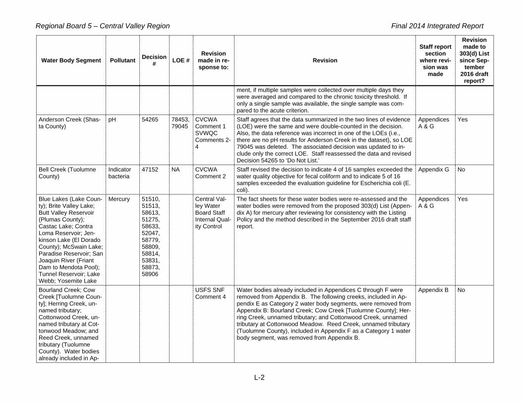
Regional Board 5 – Central Valley Region Final 2014 Integrated Report
L-2
Water Body Segment Pollutant Decision # LOE #
Revision made in re-sponse to:
Revision
Staff report section
where revi-sion was
made
Revision made to
303(d) List since Sep-
tember 2016 draft
report? ment, if multiple samples were collected over multiple days they were averaged and compared to the chronic toxicity threshold. If only a single sample was available, the single sample was com-pared to the acute criterion.
Anderson Creek (Shas-ta County)
pH 54265 78453, 79045
CVCWA Comment 1 SVWQC Comments 2-4
Staff agrees that the data summarized in the two lines of evidence (LOE) were the same and were double-counted in the decision. Also, the data reference was incorrect in one of the LOEs (i.e., there are no pH results for Anderson Creek in the dataset), so LOE 79045 was deleted. The associated decision was updated to in-clude only the correct LOE. Staff reassessed the data and revised Decision 54265 to ‘Do Not List.'
Appendices A & G
Yes
Bell Creek (Tuolumne County)
Indicator bacteria
47152 NA CVCWA Comment 2
Staff revised the decision to indicate 4 of 16 samples exceeded the water quality objective for fecal coliform and to indicate 5 of 16 samples exceeded the evaluation guideline for Escherichia coli (E. coli).
Appendix G No
Blue Lakes (Lake Coun-ty); Brite Valley Lake; Butt Valley Reservoir (Plumas County); Castac Lake; Contra Loma Reservoir; Jen-kinson Lake (El Dorado County); McSwain Lake; Paradise Reservoir; San Joaquin River (Friant Dam to Mendota Pool); Tunnel Reservoir; Lake Webb; Yosemite Lake
Mercury 51510, 51513, 58613, 51275, 58633, 52047, 58779, 58809, 58814, 53831, 58873, 58906
Central Val-ley Water Board Staff Internal Qual-ity Control
The fact sheets for these water bodies were re-assessed and the water bodies were removed from the proposed 303(d) List (Appen-dix A) for mercury after reviewing for consistency with the Listing Policy and the method described in the September 2016 draft staff report.
Appendices A & G
Yes
Bourland Creek; Cow Creek [Tuolumne Coun-ty]; Herring Creek, un-named tributary; Cottonwood Creek, un-named tributary at Cot-tonwood Meadow; and Reed Creek, unnamed tributary (Tuolumne County). Water bodies already included in Ap-
USFS SNF Comment 4
Water bodies already included in Appendices C through F were removed from Appendix B. The following creeks, included in Ap-pendix E as Category 2 water body segments, were removed from Appendix B: Bourland Creek; Cow Creek [Tuolumne County]; Her-ring Creek, unnamed tributary; and Cottonwood Creek, unnamed tributary at Cottonwood Meadow. Reed Creek, unnamed tributary (Tuolumne County), included in Appendix F as a Category 1 water body segment, was removed from Appendix B.
Appendix B No

Regional Board 5 – Central Valley Region Final 2014 Integrated Report
L-3
Water Body Segment Pollutant Decision # LOE #
Revision made in re-sponse to:
Revision
Staff report section
where revi-sion was
made
Revision made to
303(d) List since Sep-
tember 2016 draft
report? pendices C through F have been removed from Appendix B. Brack Tract Drain, at Woodbridge Rd (San Joaquin County)
Arsenic 58941 60635 (delet-ed) 60634 (re-vised)
CVCWA Comment 3
Because there is no freshwater aquatic life criterion for total arse-nic, LOE 60635 was deleted and the decision was updated to in-clude only the LOE for data that were correctly assessed as total arsenic for protection of the Municipal and Domestic Supply (MUN) beneficial use. As the commenter stated, not all of the available arsenic data were assessed for this water body. A total of 13 sam-ple results are available and 11 sample results exceeded the Cali-fornia Maximum Contaminant Level (MCL) for arsenic. The LOE and decision information have been revised accordingly, and the recommendation remains to list this water body for arsenic.
Appendix G No
Bull Meadow Creek (Tuolumne County)
Indicator Bacteria
52440 Internal staff quality control
Staff revised text in Decision 52440 to correct errors in sample and exceedance counts. The listing status is unchanged as a result of these revisions.
Appendix G No
Cantua Creek Boron 55205 79276 CVCWA Comment 4
Staff reviewed the LOE and revised the decision to indicate three of the seven samples were exceedances.
Appendix G No
Cantua Creek Boron 55205 Central Val-ley Water Board Staff Internal Qual-ity Control
40 CFR Part 122 Appendix D identifies boron on its list of “Conven-tional & Nonconventional Pollutants” and not as a “Toxic Pollutant”. Consequently, boron should have been assessed using Table 3.2 of the Listing Policy rather than Table 3.1. Staff updated the lan-guage in the Fact Sheet to reflect Table 3.2. In addition, Table 3.2 states a minimum of five exceedances is required to list a water body. Cantua Creek has seven samples with three exceedances, and this does not exceed the allowable frequency listed in Ta-ble 3.2. As a result, staff changed the listing recommendation to ‘Do Not List’.
Appendices A & G
Yes
Carson Creek (from WWTP to Deer Creek)
Aluminum, Manga-nese
44575, 33274
Central Val-ley Water Board Staff Internal Qual-ity Control
Carson Creek (from WWTP to Deer Creek) was listed for alumi-num and manganese by the 2012 Integrated Report based on Ta-ble 3.1 in the Listing Policy. However, 40 CFR Part 122 Appendix D identifies aluminum and manganese on its list of “Conventional & Nonconventional Pollutants” and not as a “Toxic Pollutant”. Con-sequently, aluminum and manganese should have been assessed using Table 3.2 of the Listing Policy rather than Table 3.1. Staff updated the language in the Fact Sheets to reflect Table 3.2. In addition, Table 3.2 states a minimum of five exceedances is re-quired to list a water body. Two of 11 aluminum samples, and 3 of 4 manganese samples for Carson Creek exceed the secondary
Appendices A & G
Yes

Regional Board 5 – Central Valley Region Final 2014 Integrated Report
L-4
Water Body Segment Pollutant Decision # LOE #
Revision made in re-sponse to:
Revision
Staff report section
where revi-sion was
made
Revision made to
303(d) List since Sep-
tember 2016 draft
report? MCL, and these do not exceed the allowable frequency listed in Table 3.2. As a result, staff changed the listing recommendations to ‘Delist’ for aluminum and manganese.
Coon Creek (from con-fluence of Orr and Dry Creeks to East Side Canal, Placer and Sutter Counties)
Indicator bacteria
55341 61764, 61775
CVCWA Comment 5
Staff revised the fecal coliform decision to indicate one of six sam-ples exceed the evaluation guideline. Staff corrected the Water Quality Objective and its reference in the LOE for E. coli. Staff revised the LOE for E. coli to indicate a total of 31 samples.
Appendix G No
Deadman Creek (Merced County)
Arsenic 59637 62201 CVCWA Comment 6
Because there is no freshwater aquatic life criterion for total arse-nic, LOE 62201 was deleted and the decision was updated to in-clude only the LOE for data that were correctly assessed as total arsenic for protection of the Municipal and Domestic Supply (MUN) beneficial use. The recommendation remains to list this water body for arsenic. The remaining LOE 62200 correctly reflects all of the available data.
Appendix G No
Deer Creek (Sacramen-to County)
Iron 39792 CVCWA Comments 9-11 & Central Valley Water Board Staff Internal Qual-ity Control
40 CFR Part 122 Appendix D identifies iron on its list of “Conven-tional & Nonconventional Pollutants” and not as a “Toxic Pollutant”. Consequently, iron should have been assessed using Table 3.2 of the Listing Policy rather than Table 3.1. Staff updated the language in the Fact Sheet to reflect Table 3.2. In addition, while all initial secondary MCL assessments were based on more conservative total recoverable values and daily samples, Title 22 is silent on whether to utilize total or dissolved concentrations or the time peri-od for assessment. CV-SALTS is currently proposing guidance for the use of secondary MCLs in source water evaluation. As a re-sult, staff changed the listing recommendation to ‘Delist’.
Deer Creek (Tulare County)
Chlorpyri-fos
61218 62621, 78656
CVCWA Comment 7
The total numbers of water and sediment samples, and the number of criteria exceedances, were reviewed and revised for consistency in the LOEs and the decision. Staff’s proposed recommendation to list Deer Creek as impaired by chlorpyrifos remains unchanged.
Appendix G No
Delta Waterways (east-ern portion)
Dissolved Oxygen
55544 62471 Stockton Permittees Comments 1 & 4
After reviewing available GIS information associated with the dis-solved oxygen data, staff concurs with the commenter that the four stations do not represent a large spatial area (i.e., the entire east-ern Delta). The available data are for the southeastern portion of Fourteenmile Slough. Staff has added a comment to the dissolved oxygen Fact Sheet for the Delta Waterways (eastern portion) not-ing that this data set applies only to the southeastern portion of Fourteenmile Slough. In addition, staff concurs with the comment-er that the sampling stations are close enough to be considered
Appendices A & G
Yes

Regional Board 5 – Central Valley Region Final 2014 Integrated Report
L-5
Water Body Segment Pollutant Decision # LOE #
Revision made in re-sponse to:
Revision
Staff report section
where revi-sion was
made
Revision made to
303(d) List since Sep-
tember 2016 draft
report? the same location per section 6.1.5.2 of the Listing Policy. Further, the California Department of Pesticide Regulation (DPR) report that describes the monitoring design states, ‘The four samples taken inside each marina and the four samples taken for each LRS <local reference site, i.e. Fourteenmile Slough> area during each sampling event represented sub-samples for that particular marina and LRS area.’ (DPR, 2009, page 15) This provides additional jus-tification for considering the four Fourteenmile Slough stations to be considered the same location. As a result, staff re-assessed the Fourteenmile Slough data as one location. The minimum dis-solved oxygen values for each of the three sampling events are 4.82, 4.35, and 6.74 mg/L, which include two exceedances of the water quality objective for Delta waters of 5 mg/L. Per Table 3.2 of the Listing Policy, a minimum of five exceedances is required to list a water body for conventional constituents. Consequently, staff changed Decision 55544 from “List on 303(d) List (TMDL required list)” to “Do Not List”. Staff also corrected the water quality objec-tive to reflect the objective of 5.0 mg/L for eastern Delta water-ways.
Delta Waterways (east-ern portion), Lake Na-toma, and Rollins Reservoir
Mercury Central Val-ley Water Board Staff Internal Qual-ity Control
Made edits to improve clarity in the draft staff report section Report section "Evaluation of Fish Tissue Mercury Data". Removed bul-lets for Delta Waterways (eastern portion), Lake Natoma, and Rol-lins Reservoir because these water bodies were already identified on the 2012 303(d) List and should not have been included in this section.
Report sec-tion "Evalua-tion of Fish Tissue Mer-cury Data"
No
Delta Waterways (southern portion)
Aluminum, Iron, Man-ganese
60683, 49278, 60684
CVCWA Comment 9-11
Staff added a comment to the aluminum Fact Sheet for the Delta Waterways (southern portion) noting that the samples were col-lected from Grant Line Canal. In addition, 40 CFR Part 122 Ap-pendix D identifies aluminum on its list of “Conventional & Nonconventional Pollutants” and not as a “Toxic Pollutant”. Con-sequently, aluminum, iron and manganese should have been as-sessed using Table 3.2 of the Listing Policy rather than Table 3.1. Staff updated the language in the Fact Sheets to reflect Table 3.2. In addition, Table 3.2 states a minimum of five exceedances is required to list a water body. The Delta Waterways (southern por-tion) has four samples with four exceedances each for aluminum, iron and manganese, and these does not exceed the allowable frequency listed in Table 3.2. As a result, staff changed the listing recommendations to ‘Do Not List’.
Appendices A & G
Yes
Delta Waterways (west- Arsenic 61023 72731 CVCWA The “Fraction” in LOE 72731 was changed to “Shellfish.” Appendix G No

Regional Board 5 – Central Valley Region Final 2014 Integrated Report
L-6
Water Body Segment Pollutant Decision # LOE #
Revision made in re-sponse to:
Revision
Staff report section
where revi-sion was
made
Revision made to
303(d) List since Sep-
tember 2016 draft
report? ern portion) Comment 12 Elbow Creek, unnamed tributary below Sheep Meadow (Alpine County)
Indicator Bacteria
52443 64439-64452, 63359, 63360
USFS Com-ment 8 Wooster Comments 1, 2 and 3
The commenter is correct that data associated with Jawbone Creek should not be associated with Elbow Creek, unnamed tribu-tary below Sheep Meadow (Alpine County), indicator bacteria De-cision 52443. The two lines of evidence for Jawbone Creek, 63352 and 63360, were removed from Decision 52443. During staff’s review of this decision, the line of evidence for total coliform (63359) was also removed because total coliform is not a reliable indicator of pathogens. The text of Decision 52443 was updated to reflect the three remaining LOEs (63349, 63350 and 63351). The decision to place Elbow Creek, unnamed tributary below Sheep Meadow (Alpine County) was consequently changed from “List on 303(d) list (TMDL required list)” to “Do Not List”. Staff corrected the assessment and changed Decision 52443 from “List on 303(d) list (TMDL required list)” to “Do Not List”.
Appendices A & G
Yes
Elk Bayou (Tulare Coun-ty)
Ammonia as N, total
61307 78427 CVCWA Comment 13
Staff reassessed the Ammonia as N data using the pH-dependent, calculated National Recommended Water Quality Criteria for total ammonia nitrogen. The number of date-averaged samples with both Ammonia as N and pH data, and the number of exceedances, were revised in the LOE and in the decision from 3 to 6, and from 3 to 0, respectively. As a result, the decision was changed from “List on 303(d) list (TMDL required list)” to “Do Not List”.
Appendices A & G
Yes
Freshwater Creek (Little Valley to Salt Creek, Colusa County)
Indicator Bacteria
60093 63962, 63964
CVCWA Comment 14
Staff revised the reference for the Criteria/Objective for the E. coli and fecal coliform LOEs to refer to the Water Quality Control Plan for the Sacramento River and San Joaquin River Basins.
Appendix G No
Honcut Creek (Butte and Yuba Counties)
Indicator Bacteria
57013 64660, 64662, 22279
CVCWA Comment 15
Staff revised the reference for the Criteria/Objective for the E. coli and fecal coliform LOEs to refer to the Water Quality Control Plan for the Sacramento River and San Joaquin River Basins.
Appendix G No
Hospital Creek Methyl Parathion
41797 WSJRWC Comments 2 & 5
Staff revised the draft 303(d) List to reflect that methyl parathion in Hospital Creek is being addressed by an action other than TMDL, rather than “TMDL Required”, and revised the fact sheet in Appen-dix G of the draft Integrated Report to include a description of the Focused Management Plan actions. Also, in response to WSJRWC’s email of September 23, 2016, staff corrected the data references for the fact sheet for Hospital Creek to indicate the data were collected by the Westside San Joaquin Water Quality Coali-tion. The online fact sheets posted in September 2016 as part of the Central Valley Water Board’s solicitation of comments could not be updated in real time. Updated fact sheets have since been
Appendices A & G
Yes

Regional Board 5 – Central Valley Region Final 2014 Integrated Report
L-7
Water Body Segment Pollutant Decision # LOE #
Revision made in re-sponse to:
Revision
Staff report section
where revi-sion was
made
Revision made to
303(d) List since Sep-
tember 2016 draft
report? posted online for public review.
Hospital Creek (San Joaquin and Stanislaus Counties)
Arsenic 36082 64749, 8447, 26572
CVCWA Comment 16
LOE 64748 was deleted and the decision was updated to include only the LOEs for data that were correctly assessed as total arse-nic for protection of the Municipal and Domestic Supply (MUN) beneficial use. The recommendation remains to list this water body for arsenic.
Appendix G No
Ingram Creek (from con-fluence with Hospital Creek to Hwy 33 cross-ing)
Arsenic 36086 8459, 26641, 65013
CVCWA Comment 17
LOE 65012 was deleted and the decision was updated to include only the LOEs for data that were correctly assessed as total arse-nic for protection of the Municipal and Domestic Supply (MUN) beneficial use. The recommendation remains to list this water body for arsenic.
Appendix G No
Jawbone Creek (Tu-olumne County)
Indicator Bacteria
52446 Central Val-ley Water Board Staff Internal Qual-ity Control
Revised sample and exceedance counts in Decision 52446. Deci-sion changed from 'List' to 'Do Not List'.
Appendices A & G
Yes
Jawbone Creek, un-named tributary (Tu-olumne County)
Indicator Bacteria
52447 Internal staff quality control
Staff revised text in Decision 52447 to correct errors in sample and exceedance counts. The listing status is unchanged as a result of these revisions.
Appendix G No
Kentucky Creek (Neva-da County)
Iron 54617 Central Val-ley Water Board Staff Internal Qual-ity Control
40 CFR Part 122 Appendix D identifies iron on its list of “Conven-tional & Nonconventional Pollutants” and not as a “Toxic Pollutant”. Consequently, iron should have been assessed using Table 3.2 of the Listing Policy rather than Table 3.1. Staff updated the language in the Fact Sheet to reflect Table 3.2. In addition, Table 3.2 states a minimum of five exceedances is required to list a water body. Kentucky Creek has two samples with two exceedances, and this does not exceed the allowable frequency listed in Table 3.2. As a result, staff changed the listing recommendation to ‘Do Not List’.
Appendices A & G
Yes
Kings River, Lower (Pine Flat Reservoir to Island Weir)
Alkalinity as CaO3
57469 79270, 78423
Central Val-ley Water Board Staff Internal Qual-ity Control
LOE 79270 was deleted because it duplicated LOE 78423. LOE 78423 was revised using the criterion as a maximum, rather than a minimum, value. Decision 57469 was revised accordingly and the proposed recommendation has not changed from “List.”
Appendix G No
Kings River, Lower (Pine Flat Reservoir to Island Weir)
Ammonia as N, To-tal
61503 78989 CVCWA Comment 18
Staff re-assessed the ammonia as N data using the pH- and tem-perature-dependent, calculated Criteria Maximum Concentrations (CMCs) for total ammonia nitrogen. None of the 63 assessed total ammonia results exceeded their respective calculated CMCs. The LOE and Decision were revised to reflect that the total number of
Appendices A & G
Yes

Regional Board 5 – Central Valley Region Final 2014 Integrated Report
L-8
Water Body Segment Pollutant Decision # LOE #
Revision made in re-sponse to:
Revision
Staff report section
where revi-sion was
made
Revision made to
303(d) List since Sep-
tember 2016 draft
report? water samples, for which the CMCs were calculated, was changed from 13 to 63, and the number of exceedances was changed from 13 to 0. As a result, the proposed decision to place Kings River, Lower (Pine Flat Reservoir to Island Weir) on the 303(d) List has been changed to “Do Not List.”
Knights Landing Ridge Cut (Yolo County)
Boron 40762 Central Val-ley Water Board Staff Internal Qual-ity Control
40 CFR Part 122 Appendix D identifies boron on its list of “Conven-tional & Nonconventional Pollutants” and not as a “Toxic Pollutant”. Consequently, boron should have been assessed using Table 3.2 of the Listing Policy rather than Table 3.1. Staff updated the lan-guage in the Fact Sheet to reflect Table 3.2. In addition, Table 3.2 states a minimum of five exceedances is required to list a water body. Knights Landing Ridge Cut has six samples with four ex-ceedances, and this does not exceed the allowable frequency listed in Table 3.2. As a result, staff changed the listing recom-mendation to ‘Delist’.
Appendices A & G
Yes
Laguna Creek (tributary to Cosumnes River, Sacramento County)
Indicator Bacteria
57791 65655 CVCWA Comment 19
Staff revised the reference for the Criteria/Objective for the E. coli LOE to refer to the narrative chemical constituent objective in the Water Quality Control Plan for the Sacramento River and San Joaquin River Basins.
Appendix G No
Laguna Creek (tributary to Cosumnes River, Sacramento County)
Oxygen, Dissolved
57789 65683 CVCWA Comment 20
The total number of samples, 23, was corrected in LOE 65683. Appendix G No
Los Banos Creek (below Los Banos Reservoir, Merced County)
Boron 39208 Central Val-ley Water Board Staff Internal Qual-ity Control
40 CFR Part 122 Appendix D identifies boron on its list of “Conven-tional & Nonconventional Pollutants” and not as a “Toxic Pollutant”. Consequently, boron should have been assessed using Table 3.2 of the Listing Policy rather than Table 3.1. Staff updated the lan-guage in the Fact Sheet to reflect Table 3.2. In addition, Table 3.2 states a minimum of five exceedances is required to list a water body. Los Banos Creek has four samples with two exceedances, and this does not exceed the allowable frequency listed in Ta-ble 3.2. As a result, staff changed the listing recommendation to ‘Delist’.
Appendices A & G
Yes
Los Gatos Creek (Fres-no County)
Boron 58337 Central Val-ley Water Board Staff Internal Qual-ity Control
40 CFR Part 122 Appendix D identifies boron on its list of “Conven-tional & Nonconventional Pollutants” and not as a “Toxic Pollutant”. Consequently, boron should have been assessed using Table 3.2 of the Listing Policy rather than Table 3.1. Staff updated the lan-guage in the Fact Sheet to reflect Table 3.2. In addition, Table 3.2 states a minimum of five exceedances is required to list a water body. Los Gatos Creek has six samples with two exceedances,
Appendices A & G
Yes

Regional Board 5 – Central Valley Region Final 2014 Integrated Report
L-9
Water Body Segment Pollutant Decision # LOE #
Revision made in re-sponse to:
Revision
Staff report section
where revi-sion was
made
Revision made to
303(d) List since Sep-
tember 2016 draft
report? and this does not exceed the allowable frequency listed in Ta-ble 3.2. As a result, staff changed the listing recommendation to ‘Do Not List’.
Main Drain (Kern Coun-ty)
Ammonia as N, To-tal
61537 78998 CVCWA Comment 21
Staff re-assessed the Ammonia as N data using the pH- and tem-perature-dependent, calculated National Recommended Water Quality Criteria for total ammonia nitrogen. The LOE and Decision were revised to reflect that the total number of water samples, for which the CMCs were calculated, was changed from six to five, and the number of exceedances was changed from six to zero. As a result, the proposed decision to place Main Drain (Kern County) on the 303(d) List has been changed to "Do Not List."
Appendices A & G
Yes
Marsh Creek (Marsh Creek Reservoir to San Joaquin River; partly in Delta Waterways, west-ern portion)
Bifenthrin 40228 80383, 80384, 59118, 59292, 59321, 59291, 22253, 22180, 22240, 22250
City of Brentwood Comments 1 through 6
Sample and exceedance counts in LOE 80383 were revised from two samples and two exceedances to zero samples and zero ex-ceedances. Sample and exceedance counts in LOE 80384 were revised from four samples and four exceedances to zero samples and zero exceedances. LOEs 59118, 59292, 59321, and 59291 have been removed from decision 40228. LOEs 22253, 22180, 22240, and 22250 are a subset of the data described in LOES # 59291 and 59321. LOEs # 22253, 22180, 22240, 22250 were re-moved from Decision 40228. Decision 40228 changed from 'List on 303(d) list (TMDL required list) to 'Do Not List on 303(d) list (TMDL required list)'.
Report sec-tion "Evalua-tion of Data for Pyre-throid Pesti-cides" and Appendices A & G
Yes
Marsh Creek (Marsh Creek Reservoir to San Joaquin River; partly in Delta Waterways, west-ern portion)
multiple 39368, 39661, 39714, 40228, 40344, 51122, 51124, 58152, 58179, 58183, 58185, 58188
66745, 66749, 66767, 66768, 66769, 66770, 66955, 66956, 66957, 66958, 66826, 66828, 66860
CVCWA Comment 22
Lines of Evidence 66749, 66767, 66768, 66769, 66770, 66955, 66956, 66957, 66958, 66826, 66828, and 66860 have been re-vised such that the assessed beneficial use is WARM rather than COLD. Decisions 39368, 39661, 39714, 40344, 51122, 51124, 58152, 58179, 58183, 58185, and 58188 have also been revised to reflect changes to the Lines of Evidence indicated above. No changes to the proposed listing decisions for Marsh Creek result from these LOE changes.
Appendix G No
Mill Creek (Fresno County)
Alkalinity as CaO3
62443 78424 CVCWA Comment 23
The criterion for alkalinity is a continuous minimum concentration (4-day average) of 20 mg/L or more as CaCO3. Staff corrected LOE 78424 and associated Decision 62443. As a result, the pro-posed recommendation to place Mill Creek (Fresno County) on the
Appendices A & G
Yes

Regional Board 5 – Central Valley Region Final 2014 Integrated Report
L-10
Water Body Segment Pollutant Decision # LOE #
Revision made in re-sponse to:
Revision
Staff report section
where revi-sion was
made
Revision made to
303(d) List since Sep-
tember 2016 draft
report? 303(d) List has been changed to “Do Not List.”
Mill Creek (Fresno County)
Ammonia as N, To-tal
61539 79004 CVCWA Comment 24
Staff re-assessed the ammonia as N data using the pH- and tem-perature-dependent, calculated Criteria Maximum Concentrations (CMCs) for total ammonia nitrogen. The LOE and Decision were revised to reflect that the total number of water samples, for which the CMCs were calculated, was changed from 2 to 11, and the number of exceedances was changed from 2 to 0. As a result, the proposed recommendation to place Mill Creek (Fresno County) on the 303(d) List has been changed to “Do Not List.”
Appendices A & G
Yes
Mill Creek (Tulare Coun-ty)
Ammonia (Union-ized)
61550 79011 CVCWA Comment 25
LOE 79011 was deleted because it was based on data for another Mill Creek water body, and associated Decision 61550 was revised to include LOE 67313 only. The recommendation has not changed; the available data still support placing Mill Creek (Tulare County) on the 303(d) List for unionized ammonia.
Appendix G No
Natoma, Lake Toxicity 61547 68214 SSQP Com-ments 5 & 8
Line of evidence 68214 has been revised to identify Hyalella az-teca as the test species. Reference 3992 has been amended to include a publication describing sampling and testing methods for these data (Weston and Lydy, 2012). Line of Evidence 68214 was revised to reflect one exceedance out of nine samples and Deci-sion 61547 was revised to recommend ‘Do Not List.’
Appendices A & G
Yes
Newman Wasteway Boron 39562 40 CFR Part 122 Appendix D identifies boron on its list of “Conven-tional & Nonconventional Pollutants” and not as a “Toxic Pollutant”. Consequently, boron should have been assessed using Table 3.2 of the Listing Policy rather than Table 3.1. Staff updated the lan-guage in the Fact Sheet to reflect Table 3.2. In addition, Table 3.2 states a minimum of five exceedances is required to list a water body. Newman Wasteway has four samples with two exceedanc-es, and this does not exceed the allowable frequency listed in Ta-ble 3.2. As a result, staff changed the listing recommendation to ‘Delist’.
Appendices A & G
Yes
North Canyon Creek (El Dorado County)
Indicator Bacteria
40419 68296, 68304, 23113
CVCWA Comment 26
Staff revised the reference for the Criteria/Objective for the E. coli and fecal coliform LOEs to refer to the Water Quality Control Plan for the Sacramento River and San Joaquin River Basins.
Appendix G No
Old River (San Joaquin River to Delta-Mendota Canal; in Delta Water-ways, southern portion)
Aluminum, Iron, Man-ganese
50448, 60713, 50508
CVCWA Comments 27, 28, 30
Staff revised the sample and exceedance counts to fourteen and thirteen, respectively, in LOE 68402 and in Decision 50448 for aluminum. In addition, 40 CFR Part 122 Appendix D identifies aluminum on its list of “Conventional & Nonconventional Pollutants” and not as a “Toxic Pollutant”. Consequently, aluminum, iron and manganese should have been assessed using Table 3.2 of the
Appendices A & G
Yes

Regional Board 5 – Central Valley Region Final 2014 Integrated Report
L-11
Water Body Segment Pollutant Decision # LOE #
Revision made in re-sponse to:
Revision
Staff report section
where revi-sion was
made
Revision made to
303(d) List since Sep-
tember 2016 draft
report? Listing Policy rather than Table 3.1. Staff updated the language in the Fact Sheets to reflect Table 3.2. Finally, while all initial sec-ondary MCL assessments were based on more conservative total recoverable values and daily samples, Title 22 is silent on whether to utilize total or dissolved concentrations or the time period for assessment. CV-SALTS is currently proposing guidance for the use of secondary MCLs in source water evaluation. As a result, staff changed the listing recommendations to ‘Do Not List’.
Old River (San Joaquin River to Delta-Mendota Canal; in Delta Water-ways, southern portion)
Lead 40869 68412, 20793
CVCWA Comment 29
Staff revised the sample and exceedance counts to 14 and 0, re-spectively, in LOE 68412 and in Decision 40869. The LOE and Decision were also revised to compare total lead concentrations with the primary MCL for lead. The proposed recommendation has been changed to “Do Not List” because the available data do not exceed the MUN criterion for lead.
Appendices A & G
Yes
Oregon Creek (Yuba and Sierra Counties)
Copper 54173 68521 CVCWA Comment 31
Data were correctly evaluated in Line of Evidence 68521 using dissolved copper concentrations and the analyte fraction was re-vised to ‘Dissolved’.
Appendix G No
Oregon Creek (Yuba and Sierra Counties)
Iron 54174 Central Val-ley Water Board Staff Internal Qual-ity Control
40 CFR Part 122 Appendix D identifies iron on its list of “Conven-tional & Nonconventional Pollutants” and not as a “Toxic Pollutant”. Consequently, iron should have been assessed using Table 3.2 of the Listing Policy rather than Table 3.1. Staff updated the language in the Fact Sheet to reflect Table 3.2. In addition, Table 3.2 states a minimum of five exceedances is required to list a water body. Oregon Creek has 12 samples with 2 exceedances, and this does not exceed the allowable frequency listed in Table 3.2. As a result, staff changed the listing recommendation to ‘Do Not List’.
Appendices A & G
Yes
Pleasant Grove Creek Dissolved oxygen, Pyre-throids
39449, 38497
Central Val-ley Water Board Staff Internal Qual-ity Control
The 303(d) List and associated Fact Sheets were revised to note 'This listing is for Pleasant Grove Creek upstream of Fiddyment Road.'
Appendices A & G
Yes
Putah Creek (Solano Lake to Putah Creek Sinks; partly in Delta Waterways, northwest-ern portion)
Boron 39326 Central Val-ley Water Board Staff Internal Qual-ity Control
40 CFR Part 122 Appendix D identifies boron on its list of “Conven-tional & Nonconventional Pollutants” and not as a “Toxic Pollutant”. Consequently, boron should have been assessed using Table 3.2 of the Listing Policy rather than Table 3.1. Staff updated the lan-guage in the Fact Sheet to reflect Table 3.2. In addition, Table 3.2 states a minimum of five exceedances is required to list a water body. Putah Creek has 6 samples with 2 exceedances, and this does not exceed the allowable frequency listed in Table 3.2. As a
Appendices A & G
Yes

Regional Board 5 – Central Valley Region Final 2014 Integrated Report
L-12
Water Body Segment Pollutant Decision # LOE #
Revision made in re-sponse to:
Revision
Staff report section
where revi-sion was
made
Revision made to
303(d) List since Sep-
tember 2016 draft
report? result, staff changed the listing recommendation to ‘Delist’.
Rose Creek Indicator Bacteria
52460 78397, 69420, 77245, 95807
USFS SNF Comment 9
Staff reevaluated the available data for E. coli in Rose Creek (Tu-olumne County). A total of 24 E. coli samples were collected be-tween August 27, 2009 and August 13, 2010. From these 24 samples, 14 30-day geometric mean concentrations were calculat-ed. Eight of 14 calculated geometric mean concentrations ex-ceeded the allowable concentration of 126/100 ml. Line of Evidence 69420 and Decision 52460 have been revised to reflect this change. Because there continue to be exceedances of objec-tives in Rose Creek, the recommendation to list it as impaired re-mains unchanged.
Appendix G No
Rose Creek (Tuolumne County)
Indicator Bacteria
52460 Central Val-ley Water Board Staff Internal Qual-ity Control
Staff revised text in Decision 52460 to correct errors in sample and exceedance counts. The listing status is unchanged as a result of these revisions.
Appendix G No
Sacramento River (Cot-tonwood Creek to Red Bluff)
Tempera-ture
57656 69509 USEPA Comments(a)
The draft public-review version of this LOE and decision used an incorrect evaluation guideline for assessing the temperature data. The decision was revised using the appropriate water body-specific water quality objective in the Sacramento River and San Joaquin River Basin Plan to assess the available water temperature data. The revised version changed the total number of exceedances from 0 (of 1 sample) to 1 (of 1 sample). This change had no effect on staff’s recommendation of ‘Do Not List’.
Appendix G No
Sacramento River (Knights Landing to the Delta)
Tempera-ture
57832 69701, 69702
USEPA Comments(a)
The draft public-review, version of this LOE and decision used an incorrect evaluation guideline for assessing the temperature data. The decision was revised using the appropriate water body-specific water quality objective in the Sacramento River and San Joaquin River Basin Plan to assess the available water temperature data. The revised version changed the total number of exceedances from 6 (of 31 samples) to 21 (of 31 samples). This change had no effect on staff’s recommendation of ‘Do Not List’.
Appendix G No
Sacramento River (Knights Landing to the Delta)
Toxicity 44604 69497 SSD-PWG Comment 12
LOE 69497 was retired because the data were for another water-body, and Decision 44604 was revised accordingly.
Appendix G No
Sacramento River (Red Bluff to Knights Landing)
Tempera-ture
57670 69613, 69614
USEPA Comments(a)
The draft public-review version of this LOE and decision used an incorrect evaluation guideline for assessing the temperature data. The decision was revised using the appropriate water body-specific water quality objective in the Sacramento River and San Joaquin
Appendix G No

Regional Board 5 – Central Valley Region Final 2014 Integrated Report
L-13
Water Body Segment Pollutant Decision # LOE #
Revision made in re-sponse to:
Revision
Staff report section
where revi-sion was
made
Revision made to
303(d) List since Sep-
tember 2016 draft
report? River Basins Basin Plan to assess the available water temperature data. The revised version did not change the total number of ex-ceedances (1 exceedance of 3 samples). This change had no ef-fect on staff’s recommendation of ‘do not list’.
Sand Creek (tributary to Marsh Creek, Contra Costa County; partly in Delta Waterways, west-ern portion)
Bifenthrin 38173 70466 Central Val-ley Water Board Staff Internal Qual-ity Control
Data presented in LOE 70466 represent total bifenthrin concentra-tions. The fraction identified in LOE 70466 was revised to 'Total' as noted in the laboratory result. Criteria used in the assessment of bifenthrin data are intended to evaluate the freely dissolved frac-tion of bifenthrin in water. LOE 70466 has been revised to show zero samples and zero exceedances. Freely dissolved fractions of bifenthrin are not available for this water body segment. The deci-sion for bifenthrin in Sand Creek (tributary to Marsh Creek, Contra Costa County; partly in Delta Waterways, western portion) has been changed to 'Do No List'
Report sec-tion "Evalua-tion of Data for Pyre-throid Pesti-cides" and Appendices A & G
Yes
Scotchman Creek (Ne-vada County)
Iron 53986 Central Val-ley Water Board Staff Internal Qual-ity Control
40 CFR Part 122 Appendix D identifies iron on its list of “Conven-tional & Nonconventional Pollutants” and not as a “Toxic Pollutant”. Consequently, iron should have been assessed using Table 3.2 of the Listing Policy rather than Table 3.1. Staff updated the language in the Fact Sheet to reflect Table 3.2. In addition, Table 3.2 states a minimum of five exceedances is required to list a water body. Scotchman Creek has 11 samples with 2 exceedances, and this does not exceed the allowable frequency listed in Table 3.2. As a result, staff changed the listing recommendation to ‘Do Not List’.
Appendices A & G
Yes
Snake River (Butte and Sutter Counties)
Indicator Bacteria
57358 71727, 71755, 71555
CVCWA Comment 33
Staff revised the reference for the Criteria/Objective for the E. coli and fecal coliform LOEs to refer to the Water Quality Control Plan for the Sacramento River and San Joaquin River Basins.
Appendix G No
Spanish Creek (Plumas County)
Indicator Bacteria
38133 23387, 71880, 71855
CVCWA Comment 34
Staff revised the decision to indicate that three lines of evidence are available to assess E. coli, and they revised the evaluation guideline to specify E. coli. Staff also revised the reference to the Numeric Water Quality Objectives in the Listing Policy, from sec-tion 3.1 to section 3.2.
Appendix G No
Spring Creek (Nevada County)
Iron 54702 Central Val-ley Water Board Staff Internal Qual-ity Control
40 CFR Part 122 Appendix D identifies iron on its list of “Conven-tional & Nonconventional Pollutants” and not as a “Toxic Pollutant”. Consequently, iron should have been assessed using Table 3.2 of the Listing Policy rather than Table 3.1. Staff updated the language in the Fact Sheet to reflect Table 3.2. In addition, Table 3.2 states a minimum of five exceedances is required to list a water body. Spring Creek has 15 samples with 2 exceedances, and this does not exceed the allowable frequency listed in Table 3.2. As a result,
Appendices A & G
Yes

Regional Board 5 – Central Valley Region Final 2014 Integrated Report
L-14
Water Body Segment Pollutant Decision # LOE #
Revision made in re-sponse to:
Revision
Staff report section
where revi-sion was
made
Revision made to
303(d) List since Sep-
tember 2016 draft
report? staff changed the listing recommendation to ‘Do Not List’.
Stanislaus National For-est creeks
Indicator Bacteria
47152, 52440, 52447, 52460, 58659
General Comment #2 for Stanislaus NF creeks
Updated the decision recommendations to add “natural sources” and “source unknown” in addition to “grazing-related sources”.
Appendix G Yes
Twain Harte Creek (Tu-olumne County)
Indicator Bacteria
58569 Central Val-ley Water Board Staff Internal Qual-ity Control
Staff revised text in Decision 58569 to correct errors in sample and exceedance counts. The listing status is unchanged as a result of these revisions.
Appendix G No
Village West Marina (part of Delta Water-ways (eastern portion)
Dissolved Oxygen
56904 72098 Stockton Permittees Comments 2 & 5
After reviewing available GIS information associated with the data for the four Village West Marina stations, staff concurs with the commenter that the sampling stations are close enough to be con-sidered the same location per section 6.1.5.2 of the Listing Policy. Further, the California Department of Pesticide Regulation (DPR) report that describes the monitoring design states, ‘The four sam-ples taken inside each marina and the four samples taken for each LRS <local reference site> area during each sampling event repre-sented sub-samples for that particular marina and LRS area.’ (DPR, 2009, page 15) This provides additional justification for con-sidering the four Village West Marina stations to be considered the same location. As a result, staff re-assessed the Village West Ma-rina data as one location. The minimum dissolved oxygen values for each of the three sampling events are 4.79, 3.55, and 6.46 mg/L, which include two exceedances of the water quality objective for Delta waters of 5 mg/L. Per Table 3.2 of the Listing Policy, a minimum of five exceedances is required to list a water body for conventional constituents. Consequently, staff changed Decision 56904 from “List on 303(d) list (TMDL required list)” to “Do Not List”. Staff also corrected the water quality objective to reflect the objective of 5.0 mg/L for eastern Delta waterways.
Appendices A & G
Yes
Wadsworth Canal Indicator Bacteria
37369 72129, 23225
CVCWA Comment 35
Staff revised LOE 72129 to refer to the Water Quality Control Plan for the Sacramento River and San Joaquin River Basins for the appropriate toxicity water quality objective. The recommendation is still to place Wadsworth Canal on the 303(d) List for indicator bac-teria.
Appendix G No
Walker Creek (Glenn County)
Indicator Bacteria
58698 72131, 72133,
CVCWA Comment 36
Staff revised the reference for the Criteria/Objective for the E. coli and fecal coliform LOEs to refer to the Water Quality Control Plan
Appendix G No

Regional Board 5 – Central Valley Region Final 2014 Integrated Report
L-15
Water Body Segment Pollutant Decision # LOE #
Revision made in re-sponse to:
Revision
Staff report section
where revi-sion was
made
Revision made to
303(d) List since Sep-
tember 2016 draft
report? 72002 for the Sacramento River and San Joaquin River Basins. Also, the
"Water Quality Objective/Criterion" was corrected in the Line of Evidence for E. coli. During staff’s review of this decision, the Line of Evidence for total coliform (LOE 72002) was removed because total coliform is not a reliable indicator of pathogens.
Willow Slough Bypass (Yolo County)
Selenium 37499 72625, 72626
CVCWA Comment 37
Staff revised the total number of water samples to 16 in both LOEs. Zero of the 16 water samples exceed the California primary maxi-mum contaminant level for the MUN beneficial use, and two of the 16 water samples exceed the California Toxics Rule continuous concentration criterion for COLD, freshwater aquatic life habitat. The correction does not affect the recommendation to place Willow Slough Bypass (Yolo County) on the 303(d) List for selenium.
Appendix G No
Yuba River, Lower pH 54958 59383 PG&E Com-ments 6 & 7
Staff re-examined the pH data used in the draft assessment for Yuba River, Lower and identified a total of 11 excursions from the water quality objective for pH out of a total of 139 daily maximum or minimum pH values (when only useable data were included). Line of Evidence 59383 has been revised to correct the number of samples and number exceedances. Per Table 3.2 of the Listing Policy, this does not exceed the allowable frequency for conven-tional pollutants. Staff no longer proposes to add Yuba River, Lower to the 303(d) list as impaired for pH.
Appendices A & G
Yes
Yuba River, South Fork (Headwaters to Spauld-ing Lake
pH 54786 59390 PG&E Com-ments 10, 11 & 12
Line of Evidence 59390 was revised to correct the reference to the data used in the assessment: South Yuba River Citizens League – Data in Yuba: metal, 2000-2007 and conventional, 2000-2010. Staff re-examined the data pH data used in the draft assessment for Yuba River, South Fork (Headwaters to Spaulding Lake) and identified a total of 16 excursions from the water quality objective for pH out of a total of 81 daily maximum or minimum pH values (when only useable data were included). Line of Evidence 59390 has been revised to correct the number of samples and number exceedances. Per Table 3.2 of the Listing Policy, this exceeds the allowable frequency for conventional pollutants. Staff continues to propose to add Yuba River, South Fork (Headwaters to Spaulding Lake) to the 303(d) List as impaired for pH.
Appendix G No
Yuba River, South Fork (Spaulding Reservoir to Englebright Reservoir)
Copper 60689 NA CVCWA Comment 38
Staff revised the total number of samples described in the decision to “thirty-six” to be consistent with the two LOEs. The correction does not affect the decision to place Yuba River, South Fork (Spaulding Reservoir to Englebright Reservoir) on the 303(d) List for copper.
Appendix G No

Regional Board 5 – Central Valley Region Final 2014 Integrated Report
L-16
Water Body Segment Pollutant Decision # LOE #
Revision made in re-sponse to:
Revision
Staff report section
where revi-sion was
made
Revision made to
303(d) List since Sep-
tember 2016 draft
report? Yuba River, South Fork (Spaulding Reservoir to Englebright Reservoir)
Iron 60690 Central Val-ley Water Board Staff Internal Qual-ity Control
40 CFR Part 122 Appendix D identifies iron on its list of “Conven-tional & Nonconventional Pollutants” and not as a “Toxic Pollutant”. Consequently, iron should have been assessed using Table 3.2 of the Listing Policy rather than Table 3.1. Staff updated the language in the Fact Sheet to reflect Table 3.2. In addition, Table 3.2 states a minimum of five exceedances is required to list a water body. Yuba River has 20 samples with 3 exceedances, and this does not exceed the allowable frequency listed in Table 3.2. As a result, staff changed the listing recommendation to ‘Do Not List’.
Appendices A & G
Yes
Yuba River, South Fork (Spaulding Reservoir to Englebright Reservoir)
pH 58480 59393 PG&E Com-ments 3 & 4
Staff re-examined the pH data used in the draft assessment for Yuba River, South Fork (Spaulding Reservoir to Englebright Res-ervoir) and identified a total of 22 excursions from the water quality objective for pH out of a total of 277 daily maximum or minimum pH values (when only useable data were included). Line of Evi-dence 59393 has been revised to correct the number of samples and number exceedances. Per Table 3.2 of the Listing Policy, this does not exceed the allowable frequency for conventional pollu-tants. Staff no longer proposes to add Yuba River, South Fork (Spaulding Reservoir to Englebright Reservoir) to the 303(d) list as impaired for pH.
Appendices A & G
Yes
Butt Valley Reservoir (Plumas County); Jen-kinson Lake (El Dorado County); Yosemite Lake
Update to Category Report
These three water bodies were re-categorized from Category 5 to Category 1 as a result of staff changing one or more of their pollu-tant fact sheet recommendations from “List” to “Do Not List” in re-sponse to public comments and re-assessments.
Blue Lakes (Lake Coun-ty); Brite Valley Lake; Castac Lake; Contra Loma Reservoir; Elbow Creek, unnamed tribu-tary below Sheep Meadow (Alpine Coun-ty); Jawbone Creek (Tu-olumne County); McSwain Lake; Para-dise Reservoir; Tunnel Reservoir; Village West Marina (part of Delta Waterways (eastern portion); Webb, Lake
Update to Category Report
These 11 water bodies were re-categorized from Category 5 to Category 2 as a result of staff changing one or more of their pollu-tant fact sheet recommendations from “List” to “Do Not List” in re-sponse to public comments and re-assessments.

Regional Board 5 – Central Valley Region Final 2014 Integrated Report
L-17
Water Body Segment Pollutant Decision # LOE #
Revision made in re-sponse to:
Revision
Staff report section
where revi-sion was
made
Revision made to
303(d) List since Sep-
tember 2016 draft
report? Multiple E. coli Multiple Mult-
iple Central Val-ley Water Board Staff Internal Qual-ity Control
For all E. coli LOEs, staff will replace the narrative toxicity objective with the narrative chemical constituents objective. This change had no effect on listing recommendations.
Appendix G No
(a) The U.S. Environmental Protection Agency (USEPA) submitted written comments on 3 November 2016, after the formal public comment period closed, and conse-quently were not included in Appendix K: Response to Comments. The Central Valley Water Board Chair admitted the comments to the record and the Central Valley Water Board staff provided responses to the comments during the 5 December 2016 Board Hearing.