california geological survey fault evaluation report fer...
TRANSCRIPT
CALIFORNIA GEOLOGICAL SURVEY FAULT EVALUATION REPORT FER 253 SUPPLEMENT NO. 1
THE HOLLYWOOD FAULT in the Hollywood 7.5’ Quadrangle
Los Angeles County, California by Janis L. Hernandez Engineering Geologist
November 5, 2014
INTRODUCTION
The Hollywood Fault zone was previously evaluated by Hernandez and Treiman (2014). Traces of the fault zone were found to be sufficiently active and well-defined for zoning under the Alquist-Priolo Earthquake Fault Zone Act (Bryant and Hart, 2007). A preliminary review map showing the recommended Alquist-Priolo Earthquake Fault Zone (APEFZ) for the Hollywood quadrangle in Los Angeles County was released for public comment on January 8, 2014, and the Fault Evaluation Report was issued February 14, 2014.
The public comment period, during which written comments were received by the
California State Mining and Geology Board (SMGB), was scheduled to end April 8, 2014, but was extended until May 15, 2014. These public comments were made available to the State Geologist on May 16, 2014, and were formally transmitted to the California Geological Survey (CGS) with comments and recommendations from the SMGB on August 14, 2014.
The purpose of this supplement to the FER is to review and address these public
comments forwarded by the SMGB, comment on additional reports sent to CGS after preparation of the FER, and to comment on field observations of fault trenches and other subsurface investigations by CGS after the public comment period. The location of the study area is indicated on Figure 1 and the reader is referred to FER 253 dated February 14, 2014 for other necessary background material (ftp://206.170.189.144/pub/dmg/pubs/fer/253).
1

California Geological Survey – Supplement 1 FER 253
Figure 1- Study area of the Hollywood quadrangle and names of selected faults in the vicinity. Faults within existing
official Alquist-Priolo Earthquake Fault Zones are within yellow-shaded boundaries; other faults are indicated in black. Fault strands of the Newport-Inglewood Fault Zone are not a part of this evaluation. Source: USGS Quaternary Fault and Fold Database of the United States (http://earthquake.usgs.gov/hazards/qfaults/).
PUBLIC COMMENTS, AND RESPONSE All comments received by the SMGB are listed in Table 1. Those comments that
present technical data and analysis (noted with “*” in Table 1) are addressed in this supplemental report. Other comments of a non-technical nature fall under authority of the SMGB, and are not addressed herein.
Two of the technical comments noted in Table 1 (a report dated March 11, 2014 from
Lettis Consultants International, Inc. (LCI), and a letter with exhibits dated March 11, 2014 by Elkins Kalt Weintraub Reuben Gartside LLP) were superseded by later submittals which included additional interpretation. The April 8, 2014 letter submitted by Elkins Kalt Weintraub Reuben Gartside LLP was a transmittal for the April 8, 2014 LCI report. The latest LCI submittal is addressed here.
2

California Geological Survey – Supplement 1 FER 253
In addition to the public comments, new geologic/geotechnical information was received
and observations were made in the field subsequent to the 90 day public comment period. CGS evaluated as much new data as possible. To allow CGS time to incorporate new data into the map and supplemental FER, consultants working on fault investigations were informed that new data received before September 15, 2014 would be considered.
Table 1
Chronological Summary of Comments Received from the State Mining and Geology Board Hollywood Quadrangle Preliminary Earthquake Fault Zones Map
Comment
No.
Date
Commenter
Document
1
February 14, 2014
Elkins Kalt Weintraub Reuban Gartside, LLP
Letter titled “Request for Extension of Comment Period for Preliminary Alquist-Priolo Earthquake Fault Zone Map for the Hollywood Area of Los Angeles County”
2 February 26, 2014
Elkins Kalt Weintraub Reuban Gartside, LLP
Letter titled “Public Hearing to Receive Comments on Preliminary Earthquake Fault Zone Map for the Hollywood Quadrangle, Los Angeles County”
3
March 11, 2014
Lettis Consultants International, Inc.
Letter report titled “Technical Memorandum, Boulevard 6200 – Assessment of Fault Mapped in FER 253”
4
March 11, 2014
Elkins Kalt Weintraub Reuban Gartside, LLP
Letter with Exhibits titled “Public Hearing to Receive Comments on Preliminary Earthquake Fault Zone Map for the Hollywood Quadrangle, Los Angeles County”
5
March 13, 2014
Liner Letter title “Public Hearing March 13, 2014, Agenda
Item XI (New Business) Item No. 3 (Public Hearing)” 6
March 13, 2014
Beachwood Canyon Neighborhood Association
Comment letter
*7
March 13, 2014
Group Delta Consultants
Letter titled “Release of Preliminary Review Maps of Proposed New and Revised Earthquake Fault Zones, Earthquake Zones of Required Investigation, Hollywood Quadrangle”
8 April 2, 2014
Elkins Kalt Weintraub Reuban Gartside, LLP
Letter titled “Alquist-Priolo Earthquake Fault Zone Map for the Hollywood Quadrangle”
*9
April 8, 2014
Elkins Kalt Weintraub Reuban Gartside, LLP
Letter titled “ Technical Review Comments on Preliminary Review Maps of Proposed Alquist-Priolo Earthquake Fault Zone Map for the Hollywood Quadrangle”
*10 April 8, 2014 Cox Castle
Nicholson Letter titled “Comments on the Preliminary Earthquake Fault Zone Map for the Hollywood Quadrangle”
11
April 8, 2014
Armbruster Goldsmith & Delvac LLP
Letter title “Alquist-Priolo Earthquake Fault Zone Map – Hollywood Quadrangle – Public Comment”
*12
April 8, 2014
Lettis Consultants International, Inc.
Letter titled “Revised Technical Memorandum, Boulevard 6200 – Assessment of Fault Mapped in FER 253”
*13 April 18, 2014 David Perry Comment letter on Fault Evaluation Report FER-253
*14 May 6, 2014 Group Delta Report titled “Fault Activity Investigation”
*15
August 5, 2014
Group Delta
Letter report titled “Summary of Investigations of 4 Sites – Possible Locations of the Hollywood fault within the Draft Earthquake Fault Zones - Hollywood Quadrangle
3

California Geological Survey – Supplement 1 FER 253
One report received on September 16, 2014 is considered in this Supplemental FER; data submitted to CGS after that date was not. Both the public comments received, listed in Table 1, and reports sent directly to CGS up until September 16th, as listed in Table 2, are presented in this supplemental report and organized as in the initial FER, that is, comments and data are discussed in this report by fault segment as shown on Figure 2.
Table 2 Summary of Documents Received outside of those submitted to SMGB
for the Hollywood Quadrangle Preliminary Earthquake Fault Zones Map
Date Received
Received from
Document
2/7/2014 City of Los Angeles, Dept. of Engineering
Schmidt, P., and Burnett, F., 2014, Geotechnical Investigation of the Northeast Interceptor Sewer Phase 2A (NEIS 2A) Hollywood Fault Crossing, North American Tunneling Association, Paper # 144, 11 pages.
3/20/2014 City of Los Angeles, Dept. of Engineering
City of Los Angeles, Department of Engineering, Fault Crossing Adjusted Borings 031814_PG, Plate 4.pdf.
4/18/2014 City of Los Angeles, Grading Division
Golder Associates, Inc., 2014a, Surface fault Rupture Hazard Assessment, Proposed Residential and Commercial Development 8150 Sunset Boulevard, City of Los Angeles, CA, Project No. 123-92034-02, dated January 27, 2014.
4/18/2014 City of Los Angeles, Grading Division
Golder Associates, Inc., 2014b, Geotechnical Exploration and Recommendations Report, Proposed Residential and Commercial Development, 8150 Sunset Blvd., Los Angeles, CA, Project No. 123-92034, dated March 24, 2014.
5/27/2014 City of Los Angeles, Dept. of Engineering
City of Los Angeles Department of General Services, Standards Division, NEIS II-A Geotechnical Investigation (Fault Study), Lab No. 140-5916, W.O. No. SZC11777, Geotechnical Services File 060097, dated June 2013
5/28/2014 Metropolitan Transportation
Authority Library
Converse Consultants, Earth Sciences Associates, Geo/Resource Consultants, 1984, Geotechnical Report – Metro Rail Project, Design Unit A350, May, 1984. 08/22/2014 City of Los Angeles,
Grading Division Bay City Geology, 2014, Fault Study Investigation, Proposed New Single Family Residence, 1922 N. Oxford Avenue, Los Angeles, CA 90027, Project 1535, dated June 10, 2014.
8/22/2014 City of Los Angeles, Grading Division
Byer Geotechnical, Inc., 2014, Geologic and Soils Engineering Update, Fault Rupture Hazards Investigation, Proposed Apartment, 1769 – 1775 North Sycamore Avenue, Hollywood, CA, Project No. BG 21645, dated April 17, 2014.
8/22/2014 City of Los Angeles, Grading Division
Grover Hollingsworth and Associates, Inc., 2014, Geologic and Soils Engineering Exploration, Proposed Site Grading, Dwelling, Pool, Pool House, Guesthouse and Retaining Walls, 7476 Hillside Avenue and 1830 N. Sierra Bonita Avenue, Los Angeles, Project no. GH15737-G, dated May 20, 2014. 8/22/2014 City of Los Angeles,
Grading Division Irvine Geotechnical Inc., 2014, Geologic and Soils Engineering Exploration, Fault Rupture Hazard Evaluation, Proposed Residence, 1894 N. Stanley Avenue, Los Angeles, CA, Project No. IC 12117-I, dated March 14, 2014.
9/11/2014 Group Delta Consultants
Group Delta Consultants, Inc., 2014b, Fault Activity Investigation, 6230 Yucca Street, SW Corner of Yucca Street and Argyle Avenue, Hollywood Area, City of Los Angeles, California, GDC Project No. LA-1161 A, dated September 3, 2014. 9/12/2014 Group Delta
Consultants Group Delta Consultants, Inc., 2014d, Data from Fault Activity Investigation Report, 1750 Vine Street, Los Angeles, California, 90028, GDC Project No. LA-1191, dated September 12, 2014 (rev. 9/14). 9/16/2014 Group Delta
Consultants Group Delta Consultants, Inc., 2014c, Fault Activity Investigation, Yucca-Argyle Apartments, Champion Site, SE Corner of Yucca Street and Argyle Avenue, Hollywood District, City of Los Angeles, California, GDC Project No. LA-1183A, dated September 7, 2014.
4

California Geological Survey – Supplement 1 FER 253
Figure 2 – Index to fault segments discussed in the supplemental report. Red lines are fault traces from the Official
Alquist-Priolo Earthquake Fault Zone map, dated 11/6/2014.
ADDITIONAL RECENT STUDIES and COMMENTS - with appended response in italics.
Site localities also presented on Plate 1 of this supplemental report. Segment 1
Golder Associates, Inc. (2014a, b) prepared a Surface Fault Rupture Hazard
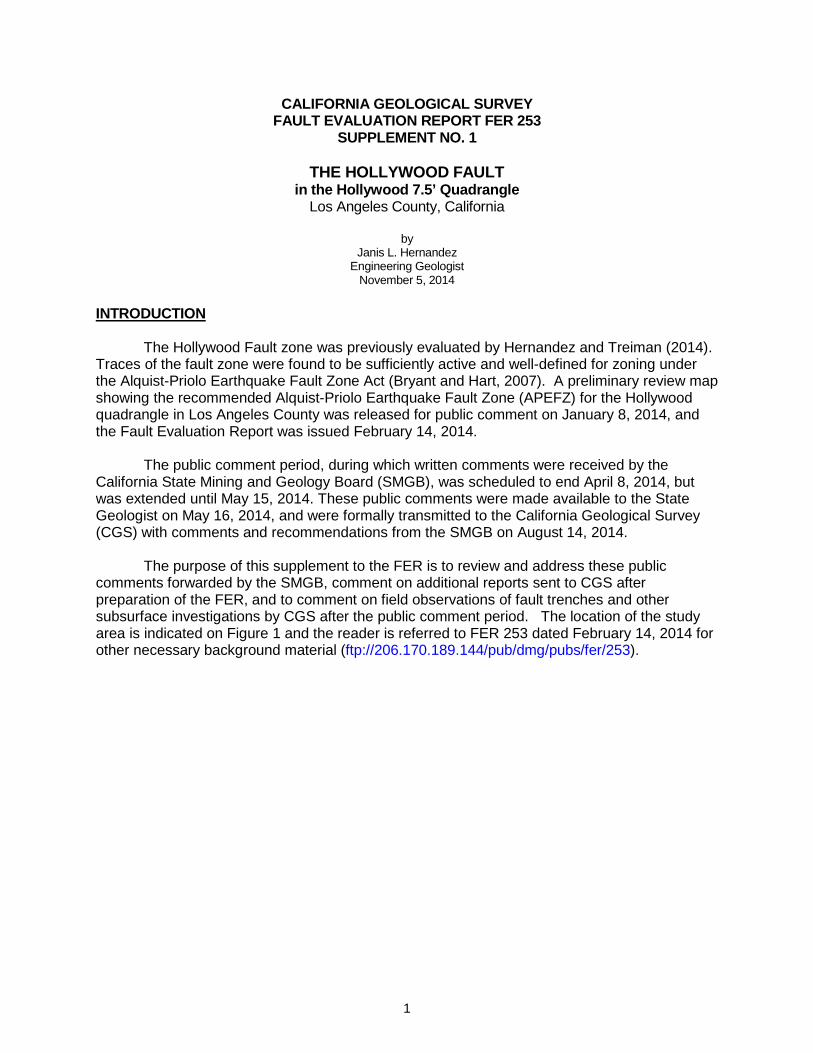
Assessment and Geotechnical Exploration study for a residential and commercial development located on the southwest corner of Sunset Boulevard and Crescent Heights (locality S1-1) as shown on Figure 3. Golder’s site evaluation included a CPT transect and hollow stem auger boreholes along the western and southern site boundaries. They interpreted this transect to show continuous alluvial stratigraphy across the site. They reported silts and gravelly sands deposited less than 7 thousand years ago (ka) to depths of about 40 feet. Lower deposits ranged in age from 9 ka to 13 ka at depths of about 60 to 80 feet. They concluded the site has not had major disruption from Holocene faulting.
The data presented by Golder Associates are consistent with the interpretation
presented in the initial FER that the Hollywood Fault lies north of this site as shown on the preliminary Alquist-Priolo Earthquake Fault Zone map.
5
California Geological Survey – Supplement 1 FER 253
Figure 3 – Study site locality S1-1 indicated in blue shaded area. Boring transect shown as dark blue patterned line.
Previous study sites included in the initial FER shown in light green. Segment 2 (western portion)
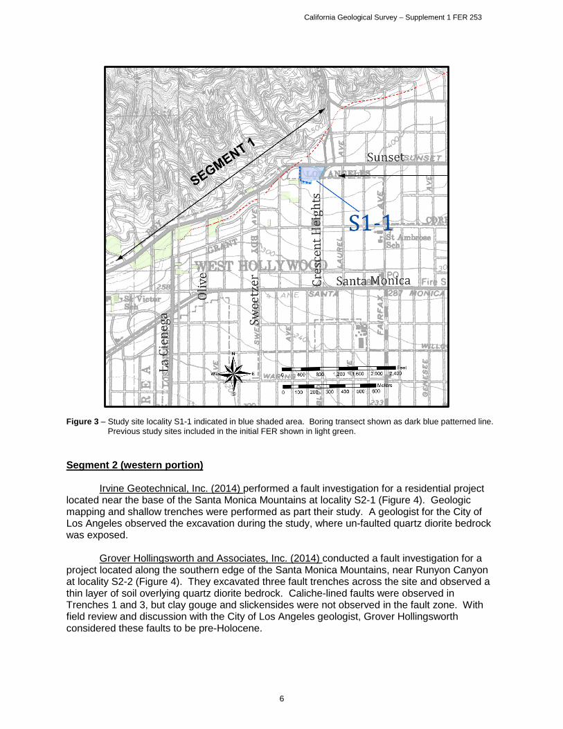
Irvine Geotechnical, Inc. (2014) performed a fault investigation for a residential project
located near the base of the Santa Monica Mountains at locality S2-1 (Figure 4). Geologic mapping and shallow trenches were performed as part their study. A geologist for the City of Los Angeles observed the excavation during the study, where un-faulted quartz diorite bedrock was exposed.
Grover Hollingsworth and Associates, Inc. (2014) conducted a fault investigation for a
project located along the southern edge of the Santa Monica Mountains, near Runyon Canyon at locality S2-2 (Figure 4). They excavated three fault trenches across the site and observed a thin layer of soil overlying quartz diorite bedrock. Caliche-lined faults were observed in Trenches 1 and 3, but clay gouge and slickensides were not observed in the fault zone. With field review and discussion with the City of Los Angeles geologist, Grover Hollingsworth considered these faults to be pre-Holocene.
6

California Geological Survey – Supplement 1 FER 253
The data presented by Irvine Geotechnical and Grover Hollingsworth and Associates for localities S2-1 and S2-2, respectively, is consistent with the interpretation that no Holocene faults cross these sites north of the fault shown on the preliminary Alquist-Priolo Earthquake Fault Zone map.
Figure 4 – Index map showing new localities S2-1 and S2-2. Trench locations indicated as orange line segments.
Previous studies included in original FER shaded green. Byer Geotechnical, Inc. (2014) prepared a fault rupture hazard investigation for a site
south of Franklin Avenue near La Brea Avenue at locality S2-3 (Figure 5). They utilized continuous core borings and seismic refraction for their study. An age date from bulk AMS C14 samples collected near the base of the young alluvium was reported as 7.1 ka. Bulk samples just below the upper contact of the old alluvium yielded ages of 20.1 ka, and 22.0 ka. Their analysis indicated unbroken stratigraphy underlying the site and they concluded there is no direct evidence for the presence of active faulting at the site.
7
California Geological Survey – Supplement 1 FER 253
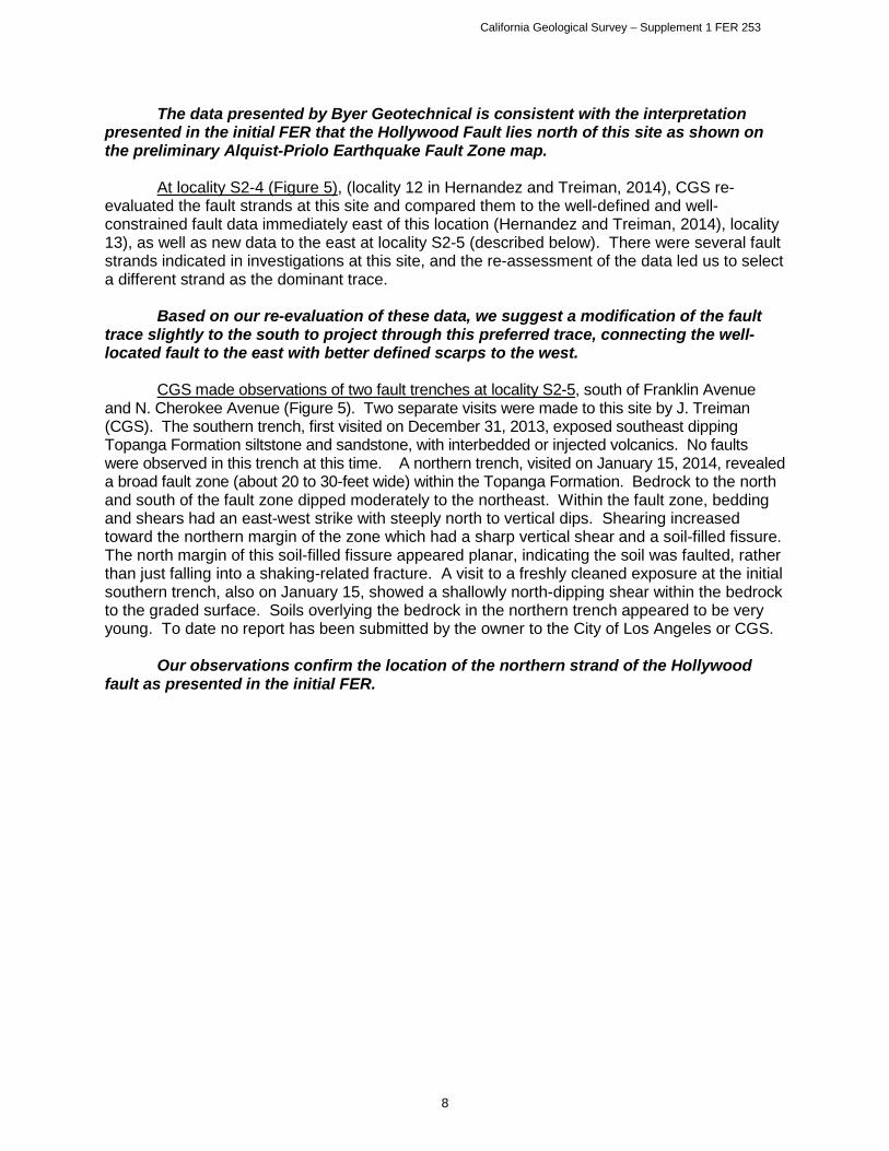
The data presented by Byer Geotechnical is consistent with the interpretation presented in the initial FER that the Hollywood Fault lies north of this site as shown on the preliminary Alquist-Priolo Earthquake Fault Zone map.
At locality S2-4 (Figure 5), (locality 12 in Hernandez and Treiman, 2014), CGS re-
evaluated the fault strands at this site and compared them to the well-defined and well-constrained fault data immediately east of this location (Hernandez and Treiman, 2014), locality 13), as well as new data to the east at locality S2-5 (described below). There were several fault strands indicated in investigations at this site, and the re-assessment of the data led us to select a different strand as the dominant trace.
Based on our re-evaluation of these data, we suggest a modification of the fault
trace slightly to the south to project through this preferred trace, connecting the well-located fault to the east with better defined scarps to the west.
CGS made observations of two fault trenches at locality S2-5, south of Franklin Avenue and N. Cherokee Avenue (Figure 5). Two separate visits were made to this site by J. Treiman (CGS). The southern trench, first visited on December 31, 2013, exposed southeast dipping Topanga Formation siltstone and sandstone, with interbedded or injected volcanics. No faults were observed in this trench at this time. A northern trench, visited on January 15, 2014, revealed a broad fault zone (about 20 to 30-feet wide) within the Topanga Formation. Bedrock to the north and south of the fault zone dipped moderately to the northeast. Within the fault zone, bedding and shears had an east-west strike with steeply north to vertical dips. Shearing increased toward the northern margin of the zone which had a sharp vertical shear and a soil-filled fissure. The north margin of this soil-filled fissure appeared planar, indicating the soil was faulted, rather than just falling into a shaking-related fracture. A visit to a freshly cleaned exposure at the initial southern trench, also on January 15, showed a shallowly north-dipping shear within the bedrock to the graded surface. Soils overlying the bedrock in the northern trench appeared to be very young. To date no report has been submitted by the owner to the City of Los Angeles or CGS.
Our observations confirm the location of the northern strand of the Hollywood
fault as presented in the initial FER.
8

California Geological Survey – Supplement 1 FER 253
Figure 5 – Localities within Segment 2; S2-3 through S2-6. Red lines indicate mapped fault trace locations for the
Official Zone Map. Black fault traces with purple hachures indicate where the fault trace was modified from the preliminary zoned trace. Green and black symbols are boring/CPT locations or transects. Orange lines are trench locations. Light blue shaded areas indicate reports received subsequent to the issuance of the FER.
Converse Consultants, Earth Sciences Associates, Geo/Resource Consultants (1984) –
locality S2-6 (Figures 5 & 7); CGS acquired a geotechnical report prepared by Converse Consultants et al (1984) for the Metro Rail Red Line Project that was not available for the initial FER (Hernandez and Treiman, 2014). The initial FER relied on data from Converse Consultants et al, (1981, 1983) and Crook and Proctor (1992), and, although the borehole data from the 1984 report were described by Crook and Proctor (1992), the original borehole logs were not in the 1981 and 1983 reports that they reference.
The data presented by Converse Consultants et al (1984), specifically a cross
section (Figure 6 herein) and boring logs, combined with observations of the fault at locality S2-5, support an eastward continuation of the northern fault trace , rather than the southeast trending orientation shown in the initial FER (that was based on Dolan et al., 1997)(Figure 7). We find the stratigraphy within the MTA boreholes reveals lateral discontinuities within the upper alluvial soils above the principal fault strands, in addition to offset bedrock as illustrated in the cross-section (Figure 6). The Converse Consultants data also supports the location of the southern trace of the fault where it crosses Cahuenga Boulevard as shown on the preliminary Alquist-Priolo Earthquake Fault Zone map. Additionally, the cross section shows a third fault that projects toward
9

California Geological Survey – Supplement 1 FER 253
the ground surface at Yucca Street, roughly between the northern and southern strands (Figure 6). Due to uncertainty as to how the various strands of this complex fault zone connect to the east and west we are only depicting the northern and southern fault traces on the Official Zone map.
Figure 6 – Cross section from the Metro Red Line subway project. Portion of figure from Converse et al, 1984. SEGMENT 2 (eastern portion)
A comment was submitted by Mr. David Waite of Cox Castle Nicholson, LLP on April 8,
2014 to the SMGB (Comment # 10, Table 1), with reference to localities S2-7 and S2-9 (Figure 7) and included a request to extend the public comment period. He referenced ongoing studies in the vicinity of Yucca Street and Argyle Avenue, and requested that this information be considered prior to issuance of the final map. Mr. Waite specifically mentions the Hollywood Millennium project, and a fault study for this project that was performed by Langan Engineering (2012). He also states that conclusions from this site-specific data were not relied upon by CGS in preparation of the fault map. Further, he concludes that the lack of evidence of a fault traversing the Millennium project does not represent a “sufficiently active, and well-defined fault.” They suggest that the map should “simply delineate supportable fault zones in which individual properties would undertake subsurface investigations, as it is fault zones which signal to localities and other constituencies that additional investigation is required.” Mr. Waite also states that additional subsurface data will be submitted to the City of Los Angeles and the State Geologist in the coming weeks and months so it could be considered in preparation of the final map.
10

California Geological Survey – Supplement 1 FER 253
CGS was invited to most of the sites referred to by Mr. Waite, where we performed limited review of trenches in the Yucca and Argyle area. Regarding our initial review of data and preparation of the initial FER, data from the Langan Engineering report for the Hollywood Millennium project was considered. However, our analysis of the subsurface correlation between borings and review of the C14 data arrived at different conclusions. Our review of the Langan (2012b) borings showed a major discontinuity between borings B-1 and B-5. This subsurface discontinuity is the boundary between gently south-dipping alluvial fan deposits to the north and fine-grained clayey deposits to the south. We interpret that this abrupt contrast in lithology indicates the presence of a fault. Regarding the statement that additional data will be submitted for this project, CGS has received no additional data for the site west of Vine Street at the time of this supplemental report, and only limited data for the site east of Vine Street.
Figure 7 - Site index of the eastern portion of Segment 2, featuring localities S2-6 through S2-12. Areas shaded in
blue include new reports submitted after the initial FER was prepared. Red fault traces indicate revised map traces. Black fault traces with purple X indicate modified areas from Preliminary EFZ map. Blue patterned line indicates boring/CPT transect, gold lines indicate fault trench locations. Magenta line at Site S2-10-11 is approximate anticline axis based on new reports by GDC (2014c)
11

California Geological Survey – Supplement 1 FER 253
Segment 2 - Localities S2-8 through S2-11 Fault studies for localities S2-8 through S2-11 were conducted by Group Delta
Consultants, Inc. (GDC) over the timespan between about February and July, 2014. CGS was provided the opportunity to perform periodic trench review of some of the trenches for these sites, however some limitations were implemented, either based on site conditions, property owners restrictions, or other reasons. A table summarizing CGS site visits in this area is provided in Appendix B of this supplemental report.
Figure 8 – Group Delta Consultants, Inc. numbered site investigations in the Yucca/Argyle area of Hollywood. Figure
modified from Group Delta’s submittal to the State Mining and Geology Board on August 14, 2014. Only data for Sites 2 and 3, and the CPT line for Site 1 were submitted to CGS in time for consideration in this Supplemental FER.
A comment was submitted by Mr. Michael Reader of Group Delta Consultants,
Inc. (GDC) on March 13, 2014 to the SMGB for locality S2-8 (GDC Site 2, Figure 8). Mr. Reader stated that although there are mapped locations where the Hollywood Fault is somewhat well-defined, in the area between Cahuenga Boulevard and Gower Street the Hollywood Fault is concealed by alluvial fans, and that no data in this area have located the active trace. He also reported that the geologic community agrees the active trace of the Hollywood Fault lies “somewhere” in this area. However, he questioned the delineation of the zone for this area, with such sparse available data.
The initial FER (Hernandez and Treiman, 2014) provides strong evidence that the
fault is well-defined to the west of the Yucca Street/Argyle Avenue area. Reasonable projection of the Hollywood Fault in this area was inferred based on supportive evidence to the west, geomorphic interpretation, and limited subsurface data. There is also good evidence the fault continues to the east, suggesting that a continuous zone of faulting extends across the map. The purpose of the map is to require investigations, like those Mr. Reader refers to in the Yucca Street/Argyle Avenue area, to ensure fault rupture is not a hazard to human lives and habitable structures.
12

California Geological Survey – Supplement 1 FER 253
A fault study, conducted by Group Delta Consultants, Inc. (2014a) was submitted to the SMGB on May 6, 2014 for locality S2-8 (GDC Site 2, Figure 8). This study included core boring and CPT transects and an approximate 100-foot long, 30 foot deep trench on the western portion of the site. GDC reported that they found no evidence for faulting in the Holocene units on this site. The study also reported age estimates of weathered soil horizons at two locations within the trench, prepared by Dr. Roy Shlemon, and included test results from two charcoal samples submitted for C14 dating.
GDC reported the site is underlain by fluvial channel deposits, locally named the Argyle
Channel, which they estimate to be Holocene. Underlying the Argyle Channel deposits, they report a clayey sand layer. The contact between the lower clayey sand and the overlying Argyle Channel sands is reported to be an erosional unconformity. The lower clayey sand is reported to be at least 12 to 15 ka, based on relative soil pedogenic development exposed in the trench. Age estimates by GDC are based on soil development described by Dr. Roy Shlemon, in Appendix B of their report, and correlation of the unconformity with ice age sea-level low stand at during marine isotope stage 2. Radiocarbon dates reported for the Argyle Channel deposits were about ~4.3 ka, and ~41 ka at about 14 feet, and 18 feet below the ground surface (bgs), respectively. GDC prefers the soil-stratigraphic and paleo-environmental age estimates for the Argyle Channel deposits and does not use the radiocarbon dates.
A second Fault Activity Report was submitted by GDC for locality S2-8, dated
September 3, 2014 (Group Delta, 2014b). This investigation consisted of additional CPT and core borings from adjacent sites in the vicinity, and an additional trench located on the eastern portion of the site that also extended south into GDC Site 1 (locality S2-9). During this second investigation, GDC reported a bedding plane fault underlies the site, where they concluded this fault is overlain by a buried paleosol “indicative of about 30 ka of weathering.” This trench was excavated in response to comments by the City of Los Angeles noting that faulted Pleistocene sediments were found directly across the street to the east (GDC, Site 3; locality S2-11). Within this eastern trench at locality S2-8, Argyle Channel deposits were exposed, underlain by mudflow deposits (previously referred to by GDC as the clayey sand or “basal clay” unit). Underlying the mudflow deposits they reported well-consolidated older alluvial debris flow deposits that are dipping gently to steeply to the south. C14 dates near the base of the Argyle Channel deposits were reported at ~4.1 to 4.3 ka. (Group Delta, 2014a, 2014b). The soil ages within the trench were derived from soil profile descriptions from R. Shlemon. GDC concluded that folding and related slip observed in their trench occurred prior to deposition of the mudflows, capped by a remnant buried paleosol of about 30 ka, and are overlain by the unbroken, estimated ~12 ka Argyle Channel deposits.
The data presented in the GDC report appear to be consistent with the
interpretation that the Argyle Channel deposits are of Holocene age. However, multiple C14 samples GDC reported within their trenches near the base of the Argyle Channel, are only ~4.3 ka and thus the channel deposits do not represent the complete Holocene record. We consider the Argyle Channel deposits to be approximately 6 ka, based on C14 data throughout the two trenches, and related soil development. The interpretation that the underlying clayey deposit is pre-Holocene appears to be consistent with the reported data. Detailed analysis of the soil profile development was prepared by G. Seitz, of CGS, and is included in Appendix A of this supplement. This analysis includes further comments regarding the reported age classification of the Argyle Channel deposits, and underlying clayey sand unit.
13

California Geological Survey – Supplement 1 FER 253
The data presented in the GDC report regarding faulting of these deposits is also open to alternate interpretations. The trench log and correlation by GDC show that Argyle Channel deposits are unfaulted across much of the site. CGS performed a field review of the west trench on two occasions, the first was not extensive enough to verify all of the consultant’s conclusions due to safety concerns, however a subsequent visit afforded the opportunity to view the clayey sand deposits and relative soil development at the base of the trench. Our review of the CPT and core boring data for GDC Site 2 finds the Argyle Channel sand unit appears to be continuously correlated between borings and CPT tests, however the underlying clayey sand unit is shown to be discontinuous across portions of the site. Our review further notes the cross sections illustrated by GDC favor the CPT correlations, where core boring data in some areas does not directly support their stratigraphic interpretation.
CGS viewed several stages of the eastern trench investigation that was placed to
potentially expose faulting that may project onto GDC Sites 1 and 2 from GDC Site 3 (to the east). Faulting was observed in this east trench at approximately 80 feet from the northern trench end, placing this fault at about the same location and orientation as the trace mapped by CGS in the Preliminary EFZ map. Further observations of this fault during June and July, 2014, revealed that age of faulting appeared to be constrained by an overlying, unfaulted mudflow deposit and paleosol, estimated to be about 30 ka by R. Shlemon (GDC, 2014c). The soil structure within the soil that overlies the fault does not exhibit rotation of pedogenic faces and appears undisturbed by movement along this particular fault trace. Two older faults, below and cut by this fault, were also observed in the tilted fan deposits but were not logged by GDC.
Based on this new trench data, as well as other data, we have relocated the
northern fault strand to project along Yucca Street toward the north. The southern fault strand is also modified in this area based on data from locality S2-9 (GDC Site 1), described below.
14

California Geological Survey – Supplement 1 FER 253
Figure 9 - View looking west at south dipping pre-Holocene bedding plane fault with a possible reverse sense of
displacement in GDC’s east trench. This trench was excavated across the southeastern portion of Site 2, and extends into Site 1; fault noted by pink flagging in the center of the photo. The upward termination of this fault, located right of Station 80 (about station 77), is within a fissure fill, which upon close inspection, is overlain by a mudflow deposit and soil, reported to be about 30 ka. In this photo, the Pleistocene age older alluvium (debris flow deposits) are overlain by a thin mudflow deposit, overlain by sands of the Argyle Channel.
Group Delta Consultants, Inc., (2014d) prepared a limited data report from a Fault
Activity Investigation for locality S2-9 (GDC Site 1, Figure 8). Their investigation included core borings, a CPT transect and an approximate 240 foot-long, 30 foot-deep trench on the eastern portion of the site (a southward extension of the trench to the north on site 2). The GDC letter report includes a summary of technical findings that includes a summary of the interpretations for other sites surrounding Site 1. The only data provided in the report are CPT logs and two interpreted CPT profiles. Trench logs, borehole logs and age dating results were not provided. GDC reported an unbroken late-Pleistocene mudflow deposit and overlying Holocene Argyle Channel deposits within Site 1.
CGS was invited to the site for periodic trench review between June 30, 2014 and
July 11, 2014, where we observed unbroken Argyle Channel deposits overlying an older unbroken unit that was tentatively correlated by GDC staff to mudflow deposits observed to the north. In the northern portion of Site 1 near the boundary with Site 2, the late-Pleistocene mudflow unit appears to be draped over the underlying folded debris flow units, and what may be the same unit appears near-horizontal as it extends to the southern end of the trench (Figure 10a).
15

California Geological Survey – Supplement 1 FER 253
We received no logs of this part of the trench to clarify these relationships. Figures 10a, 10b show the stratigraphy in the south end of the trench. Our review of the CPT data for this site, and some earlier core borings (from GDC Site2) indicates a discontinuous south-dipping Quaternary stratigraphic section, with a prominent stratigraphic break toward the southern end of the property indicative of a fault. The orientation of this break appears to be north-dipping, projects upward toward the ground surface near the southern property boundary (south of the trench exposure), is in alignment with the fault scarp located north of Carlos Avenue immediately to the east, and is in alignment with an inferred fault trace from the Langan data west of Vine Street (locality S2-7) to the west. On the basis of these observations, the southern trace of the Hollywood Fault has been moved to the southern boundary of locality S2-9, just south of the trench exposure.
Figure 10a – View looking southeast at the southern trench portion of the long eastern trench that extended from
GDC Site 2 into Site 1. Trench reveals unbroken Argyle Channel deposits extend in depth possibly to about the upper string line at the lowest bench, just left of the ladder. A bioturbated layer and thin gravel bed of uncertain age below the bottom string line below the lowest bench also appears unbroken (see Figure10b below).
16

California Geological Survey – Supplement 1 FER 253
Figure 10b – View looking at east wall at about station 235, of east trench, GDC Site 1. Close-up of poorly sorted fine-grained deposits that underlie Argyle Channel deposits. Contact with a darker, bioturbated layer is near the base of the trench, just below the blade on the scraper tool. Where exposed, unit appears continuous and unbroken through the southern end of trench bottom. Total length of trench at base is approximately 240 feet extending across GDC Site 2 toward the southern boundary of Site 1. Bottom of southern trench end is approximately 45 feet north of the southern property line.
At locality S2-10 (GDC Site 4) a single, brief site visit was conducted by J. Hernandez on
July 11, 2014, to a trench located underneath an existing parking structure. This trench revealed bedding that was relatively flat at the southern end of the trench, to gently north-dipping toward the northern end, with bedding dip increasing toward the north. This brief site visit included observations of several steep, south-dipping faults with normal south-side down sense of displacement, oriented approximately east-west. The faults projected to the ground surface underlying the parking structure and footings. Our brief observation did not find Holocene deposits within the trench. Unfortunately, the conditions of access to this trench included no photographs and no measurements of any kind, and only the above general observations can be reported here. A subsequent visit was offered by GDC for August 21, 2014 and was later cancelled. No report for this site was submitted to CGS within the September 15 deadline, and therefore newer data could not be included in this supplemental FER. Downhole observations of one bucket auger boring located in the street west of GDC Site 4 were made by J. Hernandez, which revealed depth to contact of the Argyle Channel deposits, and underlying clayey sand mudflow deposits at about 20.5 feet bgs. Due to groundwater levels rapidly rising within the southern boring, down hole observation of this second boring by CGS was prevented.
CGS also reviewed logs of test borings from Caltrans for the bridge abutments in the
area of Argyle Avenue, north of Yucca Street. These boring logs described brecciated bedrock at depth, which may be related to the northern fault trace in this vicinity.
17

California Geological Survey – Supplement 1 FER 253
Our observations of faulted older alluvial units and north-dipping bedding within the trench is consistent with a west-trending anticlinal structure along Yucca Avenue. We have modified the preliminary zone boundary to include this zone of deformation and faulting in the Official Alquist-Priolo Earthquake Fault Zone map.
At locality S2-11, (GDC Site 3, Figure 8), Group Delta (2014c) reported the site is underlain by fill materials and older alluvial debris flows, which in turn are underlain by Modelo Formation. Their site investigation included both CPT and core borings, and an approximate 8-foot deep trench on the west side of the site. GDC reported the older alluvial unit consists of Pleistocene debris flows, and state that this unit is faulted. They associated this fault with a localized west-northwest oriented anticline, which extends north to GDC Site 4, as shown in their cross-section (Figure 11). They interpret these features to be due to regional transpression and not to seismogenic faults. They report the age of the faulting at this site is older than 35 ka based on unbroken mudflow deposits found to the west at Site 2.
Figure 11 – Cross-section from GDC Site 3 showing anticlinal folding of Pleistocene debris flow deposits, inferred
stratigraphic form lines and faults that offset this unit. Numbered annotation at each fault reflects GDC’s observed stratigraphic separation at each location. Figure from GDC, 2014c.
The data presented in the GDC report is consistent with the interpretation that the
deposits are of Pleistocene age although it is unclear why these “debris flow” deposits are differentiated from the similarly comprised and deformed older alluvial fan unit exposed and described at site 2.
18

California Geological Survey – Supplement 1 FER 253
Interpretation that the faults are local bending moment faults is not consistent with CGS field observations within the trench. CGS noted a significant lack of correlation across the southernmost fault, and that thickness of units changed across most of the faults, which indicates a component of lateral displacement (Figure 12). The southernmost fault appeared to be a prominent fault, as correlative units across the fault were not found, suggesting this fault trace may have seen the most displacement. No evidence for, or against, Holocene faulting was reported on this site because Holocene deposits, if present, were likely removed during site development.
Figure 12 – At GDC Site 3, locality S2-11, view looking easterly at faulted Pleistocene alluvial fan deposits, yellow
flag indicates fault to right of shoring near the center of the photo. Gray zone at the top of the photo is concrete. Bedding gently dipping to the south (right), with steepness increasing to the south. Of the 7 faults CGS observed, most faults indicated a difference in unit thickness across fault. The southernmost fault did not have any correlative units across the fault.
A comment was submitted by Lettis Consultants International, Inc. (LCI), accompanied
by a transmittal letter by Elkins Kalt Weintraub Reuban Gartside, LLP on April 8, 2014 to the SMGB to specifically address the BLVD 6200 property located at 6201 Hollywood Boulevard in Hollywood (locality S2-12, Figure 7). In their report, they present data and analysis of the site and vicinity, with additional focus on the southern, discontinuous trace of the Hollywood Fault that is mapped on the Preliminary EFZ map to underlie the site. LCI presented detailed topographic profile analyses consisting of 3 sets of data including: review of historical 6-minute topographic maps, high-resolution lidar imagery, and high resolution ground survey topographic profiles along 8 closely-spaced, north-south oriented streets. These profiles were located within the streets adjacent to the BLVD 6200 site and along other nearby profile lines. They identified breaks in slope within the profiles of these transects, and included locations of scarps previously mapped by Dolan et al. (1997), the projection of fault traces mapped by CGS in FER 253, and the BLVD 6200 project boundary.
19
California Geological Survey – Supplement 1 FER 253
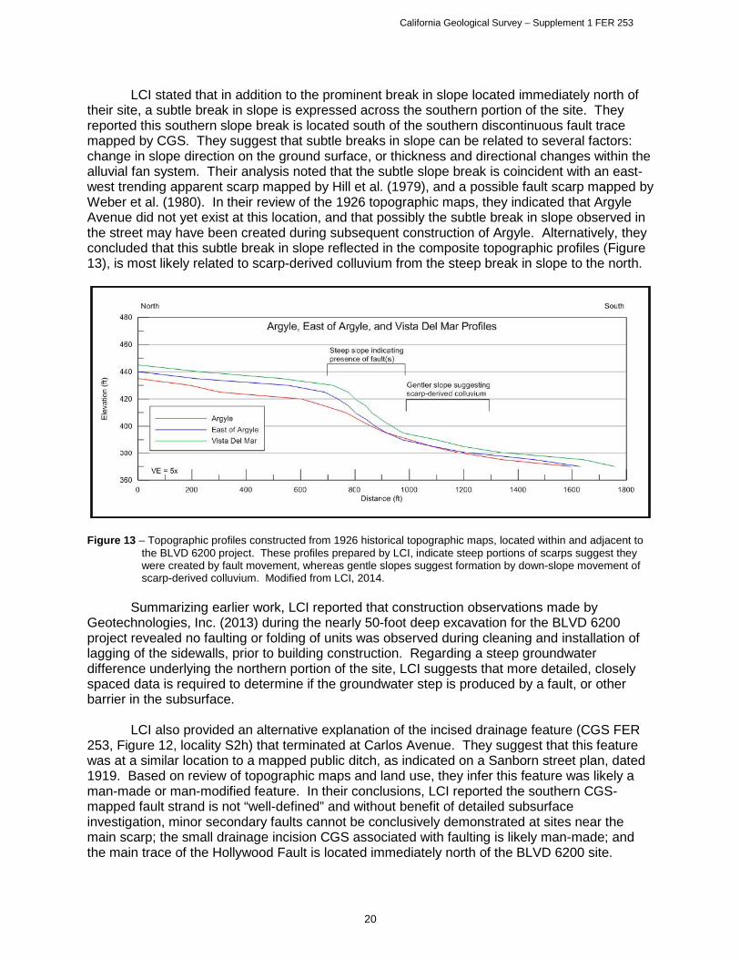
LCI stated that in addition to the prominent break in slope located immediately north of their site, a subtle break in slope is expressed across the southern portion of the site. They reported this southern slope break is located south of the southern discontinuous fault trace mapped by CGS. They suggest that subtle breaks in slope can be related to several factors: change in slope direction on the ground surface, or thickness and directional changes within the alluvial fan system. Their analysis noted that the subtle slope break is coincident with an east-west trending apparent scarp mapped by Hill et al. (1979), and a possible fault scarp mapped by Weber et al. (1980). In their review of the 1926 topographic maps, they indicated that Argyle Avenue did not yet exist at this location, and that possibly the subtle break in slope observed in the street may have been created during subsequent construction of Argyle. Alternatively, they concluded that this subtle break in slope reflected in the composite topographic profiles (Figure 13), is most likely related to scarp-derived colluvium from the steep break in slope to the north.
Figure 13 – Topographic profiles constructed from 1926 historical topographic maps, located within and adjacent to
the BLVD 6200 project. These profiles prepared by LCI, indicate steep portions of scarps suggest they were created by fault movement, whereas gentle slopes suggest formation by down-slope movement of scarp-derived colluvium. Modified from LCI, 2014.
Summarizing earlier work, LCI reported that construction observations made by
Geotechnologies, Inc. (2013) during the nearly 50-foot deep excavation for the BLVD 6200 project revealed no faulting or folding of units was observed during cleaning and installation of lagging of the sidewalls, prior to building construction. Regarding a steep groundwater difference underlying the northern portion of the site, LCI suggests that more detailed, closely spaced data is required to determine if the groundwater step is produced by a fault, or other barrier in the subsurface.
LCI also provided an alternative explanation of the incised drainage feature (CGS FER
253, Figure 12, locality S2h) that terminated at Carlos Avenue. They suggest that this feature was at a similar location to a mapped public ditch, as indicated on a Sanborn street plan, dated 1919. Based on review of topographic maps and land use, they infer this feature was likely a man-made or man-modified feature. In their conclusions, LCI reported the southern CGS-mapped fault strand is not “well-defined” and without benefit of detailed subsurface investigation, minor secondary faults cannot be conclusively demonstrated at sites near the main scarp; the small drainage incision CGS associated with faulting is likely man-made; and the main trace of the Hollywood Fault is located immediately north of the BLVD 6200 site.
20
California Geological Survey – Supplement 1 FER 253
Based on an analysis of available boring log data from adjacent studies in the area, LCI interpreted an alternative location for both the northern trace and the southern trace that they suggest would best fit the previous mapping by Dolan et al. (1997).
The data presented in the LCI report was particularly helpful in CGS review of
topographic breaks in slope. Fault traces mapped by CGS in this area were based on geomorphic interpretation using similar data as used by LCI, as well as fault traces from Dolan et al. (1997), Hill et al. (1979), and Weber et al. (1980). In addition, the southern discontinuous fault trace was mapped using original subsurface data from Geotechnologies, Inc. (2006) that included logs of borings and the site topographic base map. CGS review of the high resolution street survey data submitted by LCI in their report, and detailed observations included in the Geotechnologies (2013) report, finds justification to modify our interpretation of the location of the principal southern fault trace.
Further, CGS review of the data along Argyle Street, at locality S2-11 (GDC Site 3),
finds a section of south-dipping Quaternary fan deposits which presumably extend to the 35'-40' high slope immediately north of Carlos Avenue. This east-west trending slope has been interpreted to be a fault scarp (Dolan et al, 1997; Hernandez & Treiman, 2014; Lettis Consultants International, 2014). GDC offered the unlikely interpretation that this slope is erosional. South of Carlos Avenue, a 50-foot deep excavation for the BLVD 6200 project reportedly encountered only flat-lying sedimentary deposits (Reinard Knur, personal communication to J.Treiman) with no indication of a more indurated and tilted Pleistocene section. A letter report from Geotechnologies, Inc. dated August 16, 2013 described interlayered sands with no mention of either bedrock or deformation. The contrasting sections north and south of Carlos Avenue support a fault interpretation at this location.
Segment 3
As described above, LCI (2014) prepared several topographic profiles along north trending streets in the vicinity Yucca Street and Argyle Avenue, which included portions of both Segments 2 and 3. Their analysis included identification of breaks in slope in the area of locality S3-1 (Figure 14). LCI inferred these features were attributed to either: tectonic fault scarps (steep breaks), or alluvial fan or colluvial deposits eroding off the fault scarps (subtle breaks).
The data presented in the LCI report is helpful for reviewing the magnitude of
breaks in slope as they trend from west to east across this portion of Hollywood. As a result, the western portion of the fault trace along Segment 3 appeared to be mapped a few feet north of the base of a subtle break slope, as indicated in the LCI profiles. We have modified the fault trace closer to the base of the slope break as shown in Figure 14. This modification has no effect on the EFZ boundary at this location.
21

California Geological Survey – Supplement 1 FER 253
Figure 14 – Localities within Segment 3. North-south lines near Gower are elevation survey transect locations by
LCI. At locality S3-1, the red fault trace indicates the revised fault trace location based on breaks in slope identified within the LCI surveys. Purple cross hatch on the black fault trace indicates location of fault trace as reported in the FER. Locality S3-2 is the Bay City Geology study site. Locality S3-3 indicates the modified fault trace (in red) based on revised interpretation of the scarp utilizing the 1926 topographic base map as described in the text.
Bay City Geology, Inc. (2014) performed an investigation for a site located within the
Preliminary EFZ at locality S3-2 (Figure 14). Three large diameter borings were drilled, revealing a thin layer of older alluvium, underlain by weathered Topanga Formation siltstone and sandstone, grading to less weathered bedrock at about 21 feet bgs. Bedding planes in Topanga measured in the borings had northwest strikes, with dips to the southwest. Bay City stated that similar geologic units were encountered in all of the borings at similar depths, where they indicated this was positive evidence for continuous, unfaulted geologic units across the site. From these data, they inferred the Hollywood fault is located south of the site.
The data presented in the Bay City Geology report is consistent with the
interpretation presented in the initial FER that the Hollywood Fault lies south of this site as shown on the preliminary Alquist-Priolo Earthquake Fault Zone map.
At locality S3-3 (Figure 14), CGS revised the location of the Hollywood Fault trace along
Franklin Avenue east of Western, based on a review of the 1926 topographic map covering this area. Our initial interpretation in this area utilized a later version of the topographic map, where topographic details were more subtle. Our reinterpretation of the fault trace follows closely with the trace mapped by Dolan et al, 1997.
22

California Geological Survey – Supplement 1 FER 253
As a result of this minor adjustment, the EFZ boundary has shifted slightly to the south.
Segment 4
No new data or comments were received for Segment 4.
Segment 5
David L. Perry, comment letter dated April 18, 2014: Mr. Perry submitted a comment to the SMGB on April 18, 2014 regarding the location of the Hollywood Fault and analysis of the supporting data from the Northeast Interceptor Sewer (NEIS2A) project area (locality S5-1a) as shown on Figure 15. In this letter, Mr. Perry reports the cross-section utilized in the FER (from the Los Angeles Department of Public Works, 2013) is vertically exaggerated, and includes borings that were projected up to 63 feet horizontally into the section. In the AMEC (2013) report, he states there is a cross-section drawn at a 1:1 scale, and acknowledges subsequent boring data performed by the City of Los Angeles Department of Public Works (City of Los Angeles, 2013) was included in the cross section utilized by CGS for the FER. Mr. Perry’s interpretation of the data, and his extensive experience in this area suggests the “thickening of young alluvial deposits within the fault zone” as reported by CGS, is likely attributed to paleochannels from the Los Angeles River system, and that the projection of the data into the cross-section should include consideration of geomorphology and paleochannel geometry.
We reviewed Mr. Perry’s comments, and appreciate the insight he provides in this
area, and particularly with his experience on the NEIS project. Regarding projection of data into the NEIS profile, we acknowledge the thickness variation of recent alluvium in the vicinity of subsurface faulting may be due to erosion processes, and paleochannel morphology along the ancestral Los Angeles River system.
Patrick Schmidt, and Fred Burnett, (2014): Mr. Schmidt and Mr. Burnett of the City of
Los Angeles Bureau of Engineering (BOE) provided CGS a technical paper they prepared in February, 2014 that was submitted to the Underground Construction Association’s North American Tunneling Conference (NAT). In this paper, they discussed some of the exploratory methods implemented during the Northeast Interceptor Sewer project (NEIS), including: borings with down-hole geophysics, packer and pressuremeter testing, CPT testing, Remi surveys and surface geophysics lines. They reported some of the difficult conditions they anticipate encountering during tunneling along the fault zone, including: squeezing and running ground conditions, high methane gas concentrations, and up to 5 bars of water pressure. They reported the main Hollywood Fault was located between exploratory borings M08-B4 and M08-B5, where interpolation of the geophysical surface survey data identified two north dipping fault planes with three south-dipping secondary faults in the hanging wall that merge at depth.
This technical paper describes conditions the City of Los Angeles BOE will
encounter during tunnel excavation operations. No additional details regarding active faulting either outside or within the tunnel alignment were noted. However, their description of difficult tunneling conditions keys into the general width and local structure of the fault zone along the west bank of the Los Angeles River Valley.
23

California Geological Survey – Supplement 1 FER 253
Figure 15 - Localities S5-1a, b show where additional information was received from the City of Los Angeles, Bureau
of Engineering Department for the NEIS 2A project. Figure shows adjusted location of the Hollywood Fault trace, based on these new boring logs, cross section, and consideration of comments received from D. Perry. Red lines are final fault trace, purple cross hatch on black fault trace indicates location of fault trace as reported in the FER. Light blue line represents a segment of the NEIS tunnel alignment. Yellow lines indicate seismic profile transects. Green and blue symbols along the alignment represent core borings and monitoring wells, respectively.
City of Los Angeles (2013) conducted an additional fault study that included 3 borings
that were drilled during April - May 2013 for the NEIS 2A sewer project. These borings were drilled to further define the limits of the deep older alluvium associated with the active trace of the Hollywood Fault at locality S5-1b. The borings also helped to define the artesian groundwater pressures, depth of bedrock, and methane concentrations they will likely encounter during tunneling operations.
City of Los Angeles (2014) prepared an updated cross-section with location map
showing the investigation sites along the NEIS tunnel alignment. This new cross-section included the locations of the 3 borings presented in the 2013 report at locality S5-1b (Figure 17).
Our review of the updated cross section and boring logs received from the City of
Los Angeles (locality S5-1b), finds that the original projected surface trace of the fault should be shifted to the south approximately 90 feet. We have revised the location of the fault trace based on this new cross section and supporting data. A corresponding revision of the zone boundary has been made.
24

California Geological Survey – Supplement 1 FER 253
DISCUSSION
SEGMENT 1
Studies were received for one site along this segment (Golder Associates, 2014a, b) but
they revealed no new data that would modify our conclusions or recommendations for zoning in this area.
SEGMENT 2
Several modifications to faults within segment 2 shown on the Preliminary EFZ map are
appropriate in response to detailed fault investigations and additional interpretation. The most noticeable change is in the fault pattern. Rather than the series of en-echelon fault strands initially depicted, the official Alquist-Priolo Earthquake Fault Zone Map should depict a distinct northern and southern trace that better fit the data. The basis for these modifications are summarized below.
Northern strand of the Hollywood Fault:
Re-assessment of the preferred fault trace at site S2-4 supports the fault projection on a straighter line between well-defined faults to the east and geomorphic features to the west. Trench observations by CGS at site S2-5 revealed a soil-filled fault zone within the Topanga Formation bedrock. Faulting was oriented generally east-west, and was steeply north-dipping, suggesting the northern fault strand in this location continues along an eastward trend. The northern strand may continue across a small ridge that extends south from the general mountain front, probably marking the break between higher ground to the north and a flattened portion of that ridge at Franklin Avenue.
MTA cross sections show faulting south of Franklin Avenue near Cahuenga Boulevard
that is interpreted to be related to this strand, from there it is believed to continue along the southern margin of the truncated ridgelines to the east (at Vine Street). The northern strand continues east of Vine Street to sites S2-10 and S2-11 at the corner of Yucca and Argyle streets. There, small faults and a prominent fold in Pleistocene alluvium may be interpreted as resulting from lateral faulting and near-fault folding, though this is not the preferred interpretation of the consultants who studied this site.
Yucca Street Anticline:
GDC suggests this fold is a response to “regional transpression and not related to local faulting.” We tend to believe that the fold may be directly related to deformation associated with the Hollywood Fault. Abundant shearing in the bedrock observed by GDC and others, north of Yucca, suggests the presence of the northern strand of the Hollywood Fault Zone in this area. We see several fault-related possibilities for this fold. The fold may have been generated in much the same manner suggested by Figure C in the report for GDC Site 3 (GDC, 2014c). The pattern of folding and faulting is in general accord with the geometric relationships described by Harding (1974) for wrench fault situations.
Another possibility is that we may be seeing, within GDC Sites 3 and 4, the crest of a
broad flower structure along part of the Hollywood Fault Zone, bounded here by the north and south strands. The magnitude of offset along some of the faults, including an unknown lateral component of slip, suggests that these are more than just passive normal faults as suggested by GDC.
25

California Geological Survey – Supplement 1 FER 253
A third alternative might be that the fold was responding as a hanging wall structure above a north-dipping reverse-oblique southern strand. GDC claims that their data for GDC Site 1 preclude the presence of an active fault along the southern margin of the fold, however, having looked carefully at the data submitted we do not find this certainty and in fact find several anomalies in the CPT data that may be explained by faulting.
Southern Strand of the Hollywood Fault:
The southern strand is most strongly defined at the surface by the truncated ridge between Whitley and Wilcox (west of Cahuenga) and a similarly truncated ridge north of Carlos Avenue (east of Argyle). The location and significance of the southern strand is confirmed by the Metro borings and cross section along Cahuenga (Figure 7) and the subsurface data submitted previously by Langan (2012b; locality S2-7). A revised location of the fault at the latter location in the initial FER, due to re-evaluation of the fault dip from recent studies, is corrected in this report. Although complete continuity of the southern fault strand is not confirmed through this area, it is suggested by anomalies in a CPT transect to the east of Vine (GDC Site 1). The most prominent horizon in this transect, the base of the Argyle Channel, has several anomalous south-side-up steps that may be related to faulting, and several less-continuous units lower in the section appear to support corresponding disruptions. Some of the latter may correspond to the faults observed near the southern GDC Site 2 property line in the eastern trench for that site. However, the main zones of disruption, extending highest in the section, may lie between CPTs C-21 to C-22 and C-26 to C-29. The eastern trench at GDC Site 2 (and extending south into GDC Site 1) did not extend far enough south to fully explore these possible faults and their potential connection to the scarp at Carlos Avenue. Data from a boring log transect on GDC Site 1, that might cross the fault, have not been released.
East of Argyle Avenue the southern strand continues along the base of the slope along
Carlos Avenue. South-dipping older alluvium underlies the ground to the north, as exposed in studies for GDC Site 3, whereas alluvium exposed in a 50-foot deep excavation to the south appeared to be flat-lying (Knur, personal communication, 2014). Inspection of boring logs for that project (Geotechnologies, 2006) suggest, based on blow counts, that older fan deposits may have been encountered at depths at or below 20 feet. Analysis of the local slopes and geomorphology by LCI (2014) supports slight adjustment of the fault along Carlos Avenue.
Other splays previously mapped (Preliminary EFZ map): The fault trace previously projected southeast near Franklin Avenue and Whitley Avenue,
was mapped based on air photo interpretation of a prominent scarp at Yucca, east of Whitley, and geomorphic interpretation by Dolan et al. (1997). Based on review of MTA data, and observations of the fault at Cherokee (Site S2-5), this northern fault trace is re-oriented to project east through the fault zone identified in the MTA data, connecting with the northern fault strand at Yucca and Ivar, and the former southeast-trending trace is removed from the final map.
The plotting of the similarly oriented “Argyle strand” through GDC Site 2 had been based on
stratigraphic and hydrologic anomalies in the preliminary data that was available in 2013, data which appeared to support the prior fault interpretation by Dolan et al. (1997). Subsequent trench investigations for GDC Sites 2 and 3 have clarified the cause of these anomalies, relating them to the complex geomorphic history of this area. Consequently the previously inferred southeast-trending fault in this area is no longer a preferred interpretation for the northern fault strand. This southeast-trending segment of fault should be deleted from the EFZ map. The older fault seen in a trench at this location seems to be unrelated to the initial indications of a fault crossing this site. [Note that correlation of geologic units and interpretations relevant to
26

California Geological Survey – Supplement 1 FER 253
deeper faulting on Site 2 are very difficult to make as there are discrepancies between the boring logs submitted and the drawn sections].
The initial projection of a splay of the southern fault strand at BLVD 6200 was based on an
apparent groundwater anomaly and projection of the southern strand from the west. A re-projection of this strand along Carlos Avenue now appears to be more likely. Although splay faults are still possible, as suggested by the preliminary data, this is a minor inferred splay rather than a continuous fault trace and need not be depicted on the final map.
Summation: The Hollywood fault in segment 2 appears to include a northern and a southern trace and a
number of other minor faults and folds. Some faults within this zone may not be recently active, but the two main strands are “sufficiently active and well defined” so that an official Alquist-Priolo Earthquake Fault Zone should be established to ensure that active fault strands may be identified and avoided in the course of future development.
Segment 3 Detailed topographic profiles prepared by LCI for review of steep slope breaks along the western portion of Segment 3 provided a more regional view of fault scarps across this segment. Our review of this new data finds a better fit for the location of the fault trace in this area. Our revised interpretation of the fault trace using vintage topographic maps also provides justification for the fault trace to be re-mapped slightly south of the initial location reported in the FER.
Segment 4 No additional data has been received and no additional interpretations have been made by CGS that would result in modification of the preliminary Alquist-Priolo Earthquake Fault Zone map in segment 4.
Segment 5 Review of the new cross section prepared for the NEIS 2A tunnel alignment and consideration of the paleochannel geomorphology along the Los Angeles River has prompted a minor revision to the fault trace as it trends eastward across the Los Angeles River Valley. Our review of the updated cross section and boring logs received from the City of Los Angeles (locality S5-1b), finds that the original projected surface trace of the fault should be shifted to the south approximately 90 feet. We have revised the location of the fault trace based on this new cross section and supporting data. The location of the adjusted fault trace is shown at locality S5-1a, b, and as a result of this southern shift of the fault trace, the EFZ boundary has also been slightly modified.
27

California Geological Survey – Supplement 1 FER 253
RECOMMENDATIONS Recommendations for encompassing faults in Alquist-Priolo Earthquake Fault Zones are based on the criteria of “sufficiently active” and “well-defined” (Bryant and Hart, 2007). The principal traces of the Hollywood Fault as shown on Plate 1 are recommended for zoning as they are mostly well-defined and believed to be active.
Segment 2
• Modification of the fault trace on the west side of Highland at Franklin is recommended to align with our reassessment of the dominant trace at this site.
• Modification of the fault trace along Franklin Avenue east of Cherokee, to project the fault eastward along Franklin, is based on the youthful, soil-filled fault zone at the Cherokee site and controlled by boring data along Cahuenga Boulevard.
• Removal of the southeast-trending splay south of Franklin Avenue, east of Whitley is based on the fault realignment noted above.
• Modification of the northern fault trace at Yucca Street between Ivar Street and Argyle Avenue is recommended to better match the topography.
• The southeast-trending splay between Vine Street and Argyle Avenue is removed because it was shown to not exist in the Holocene section.
• Modification of the southern fault trace between Cahuenga Boulevard and Gower Street, is based on subsurface data and topographic expression.
Segment 3
• Modification of the western portion of this segment based on detailed street survey data from LCI (2014). Additionally, at Franklin Avenue east of Western Avenue, modification of the fault trace based on revised review of vintage topographic base map for this area.
Segment 5
• Modification of the fault trace based on adjustments to the boring locations provided in a new cross section and site map provided by the City of Los Angeles Department of Public Works.
Janis L. Hernandez PG 7237, CEG 2260 November 5, 2014
I have reviewed and concur with the recommendations in this report Jerome A. Treiman PG 3532, CEG 1035 November 5, 2014
28

California Geological Survey – Supplement 1 FER 253
REFERENCES # indicates reports received since 2/14/2014
AMEC, 2013, Geotechnical/Environmental Data Report – Northeast Interceptor Sewer Phase
2A (NEIS 2A) In the Area of the Hollywood Fault along Riverside Drive, Task Order Solicitation (TOS) 06-097G, for the City of Los Angeles Department of Public Works, Bureau of Engineering, dated July 2, 2013.
#Bay City Geology, 2014, Fault Study Investigation, Proposed New Single Family Residence,
1922 N. Oxford Avenue, Los Angeles, CA 90027, Project 1535, dated June 10, 2014. #Byer Geotechnical, Inc., 2014, Geologic and Soils Engineering Update, Fault Rupture Hazards
Investigation, Proposed Apartment, 1769 – 1775 North Sycamore Avenue, Hollywood, CA, Project No. BG 21645, dated April 17, 2014.
#California Department of Transportation Division of Maintenance, Logs of Test Borings,
Hollywood vicinity, Bridge No’s 53-0680, 53-00865K, 53-0728K, and 53-0679. #City of Los Angeles Department of General Services, Standards Division, 2013, NEIS II-A
Geotechnical Investigation (Fault Study), Lab No. 140-5916, W.O. No. SZC11777, dated June 2013, Geotechnical Services File: 06-097.
#City of Los Angeles Department of Public Works, 2014, Fault Crossing Profile: Northeast
Interceptor Sewer Phase 2A (NEIS 2A), City of Los Angeles Department of Public Works, Geotechnical Engineering Group, draft Plate No. 4, dated March 7, 2014.
#Converse Consultants, Earth Sciences Associates, Geo/Resource Consultants, 1984,
Geotechnical Report – Metro Rail Project, Design Unit A350, May, 1984. Converse Consultants, Earth Sciences Associates, Geo/Resource Consultants, 1983,
Seismological Investigation and Design Criteria, for Southern California Rapid Transit District, Metro Rail Project, dated May 15, 1983, Parts 1 and 2.
Converse Ward Davis Dixon, Earth Sciences Associates, Geo/Resource Consultants, 1981,
Geotechnical Investigation Report, Volumes 1 and 2, for Southern California Rapid Transit District, Metro Rail Project, November, 1981.
Crook, R., Jr., and Proctor, R.J., 1992, The Santa Monica and Hollywood Faults and the
Southern Boundary of the Transverse Ranges Province: in Pipkin, B.E., and Proctor, R.J., editors; Engineering Geology Practice in Southern California, Association of Engineering Geologists, Southern California Section, Special Publication 4, pp.233-246.
Dolan, J.F., Sieh, K., Rockwell, T.K., Guptill, P., and Miller, G., 1997, Active tectonics,
paleoseismology, and seismic hazards of the Hollywood fault, northern Los Angeles basin, California: GSA Bulletin, v. 109, no. 12, pp.1595-1616.
Geotechnologies, Inc., 2006, Geotechnical Engineering Investigation, Proposed BLVD6200
Development, 6200 Hollywood Boulevard, Hollywood, CA, File No. 18969, dated August 14, 2006.
29

California Geological Survey – Supplement 1 FER 253
Geotechnologies, Inc., Geotechnical Observations During Construction Proposed BLVD 6200 Development, 6201 Hollywood Boulevard, Hollywood, CA, File No. 18969, dated August 16, 2013.
#Golder Associates, Inc., 2014a, Surface fault Rupture Hazard Assessment, Proposed
Residential and Commercial Development 8150 Sunset Boulevard, City of Los Angeles, CA, Project No. 123-92034-02, dated January 27, 2014.
#Golder Associates, Inc., 2014b, Geotechnical Exploration and Recommendations Report,
Proposed Residential and Commercial Development, 8150 Sunset Blvd., Los Angeles, CA, Project No. 123-92034, dated March 24, 2014.
#Group Delta Consultants, Inc., 2014a, Fault Activity Investigation, 6230 Yucca Street,
Hollywood Area, City of Los Angeles, California, Initial Review April 2014, GDC Project No. LA-1161 A, dated May 6, 2014.
#Group Delta Consultants, Inc., 2014b, Fault Activity Investigation, 6230 Yucca Street, SW
Corner of Yucca Street and Argyle Avenue, Hollywood Area, City of Los Angeles, California, GDC Project No. LA-1161 A, dated September 3, 2014.
#Group Delta Consultants, Inc., 2014c, Fault Activity Investigation, Yucca-Argyle Apartments,
Champion Site, SE Corner of Yucca Street and Argyle Avenue, Hollywood District, City of Los Angeles, California, GDC Project No. LA-1183A, dated September 7, 2014.
#Group Delta Consultants, Inc., 2014d, Data from Fault Activity Investigation Report, 1750 Vine
Street, Los Angeles, California, 90028, GDC Project No. LA-1191, dated September 12, 2014(rev. 9/14).
#Grover Hollingsworth and Associates, Inc., 2014, Geologic and Soils Engineering Exploration,
Proposed Site Grading, Dwelling, Pool, Pool House, Guesthouse and Retaining Walls, 7476 Hillside Avenue and 1830 N. Sierra Bonita Avenue, Los Angeles, Project no. GH15737-G, dated May 20, 2014.
Harding, T.P., 1974, Petroleum Traps Associated with Wrench Faults, American Association of
Petroleum Geologists Bulletin, v. 58, No. 7 (July 1974), p. 1290-1304, 15 Figs. Hernandez, J.L., and Treiman, J.T., 2014, Fault Evaluation Report (FER 253), The Hollywood
Fault in the Hollywood 7.5’ quadrangle, Los Angeles County, California: California Geological Survey, dated February 14, 2014.
Hill, R.L., Sprotte, E.C., Chapman, R.H., Chase, G.W., Bennett, J.H., Real, C.R., Slade, R.C.,
Borchardt, G., Weber, F.H., 1979, Earthquake Hazards Associated with faults in the Greater Los Angeles Metropolitan area, Los Angeles County, California, including faults in the Santa Monica-Raymond, Verdugo-Eagle Rock, and Benedict Canyon Fault Zones, California Division of Mines and Geology, Open File Report 79-16 LA.
#Irvine Geotechnical Inc., 2014, Geologic and Soils Engineering Exploration, Fault Rupture
Hazard Evaluation, Proposed Residence, 1894 N. Stanley Avenue, Los Angeles, CA, Project No. IC 12117-I, dated March 14, 2014.
30
California Geological Survey – Supplement 1 FER 253
Langan Engineering & Environment al Services, 2012a, Preliminary Geotechnical Engineering Study, Millennium Hollywood Development, Hollywood, CA, Project No. 700019501, dated May 10, 2012.
Langan Engineering & Environmental Services, 2012b, Fault Investigation Report for the
Hollywood Development, Vesting Tentative Tact 71837, 1720 – 1770 N. Vine Street, 1745 – 1753 N. Vine Street, 6236 – 6334 W. Yucca Street, 1733 – 1741 N. Argyle Avenue, 1746 – 1764 N. Ivar Street, Hollywood, CA, Project No. 70019502, dated November 30, 2012.
#Lettis Consultants International, Inc., 2014, Revised Technical Memorandum, Boulevard 6200
– Assessment of Fault Mapped in FER 253, 6201 Hollywood Boulevard, Hollywood, California, LCI Project No. 1106.000, dated April 8, 2014.
#Perry, David L., 2014, Comments on Fault Evaluation Report 253 for the Hollywood Fault:
letter to Steven Testa, State Mining and Geology Board, dated April 18, 2014. #Schmidt, P., and Burnett, F., 2014, Geotechnical Investigation of the Northeast Interceptor
Sewer Phase 2A (NEIS 2A) Hollywood Fault Crossing, North American Tunneling Association, Paper # 144, 11 pages.
Weber, F. H. Jr., Bennett, J.H., Chapman, R.H., Chase, G.W., and Saul, R.B., 1980,
Earthquake Hazards Associated with the Verdugo-Eagle Rock and Benedict Canyon Fault Zones, Los Angeles County, California: California Division of Mines and Geology, Open File Report 80-10 LA.
31

California Geological Survey – Supplement 1 FER 253
Appendix A – Review of Soil-Stratigraphic and Paleo-Environmental Reconstruction GDC Trench - Fault Activity Investigation
6230 Yucca Street, Hollywood Area City of Los Angeles, California, report dated May 6, 2014.
Review by G. Seitz, CGS, Menlo Park This fault activity investigation report lists 7 objectives that in part will be re-evaluated here. The focus is on the chronology of a stratigraphic section. The numbered points below are from the reviewed report. 2.) To determine the approximate age of the exposed sediments based mainly on relative soil-profile development of the several paleosols encountered in the trench; The stratigraphic section of interest named the “Argyle Channel” consists of a sequence of clastic nested channel deposits cut into an underlying clay unit. At the onset (p.3), it is asserted that the contact between the channel and the clay represents a regional unconformity, a major climate change and the onset of “pluvial conditions”, and is judged “conservatively” to have taken place ~12-16 ka ago associated with marine oxygen-isotope stage 2. The base of the channels are interpreted to be at least ~10-12 ka old, based on this assumption that the unconformity represents a regional climate change along with interpretations about the time required to form paleosols within the channel deposits. No evidence was presented to show that the contact at the base of the “Argyle Channel” is in fact a regional unconformity as opposed to a more common local unconformity controlled by any number of geomorphic thresholds. The conclusion that this contact must be ~12-16 ka old is speculative. The time represented by the sequence of nested channel deposits is based on 5 channel units identified as paleosols. These are described and time required to form each horizon is estimated based on selected soil stratigraphic characteristics such as pedogenic clay accumulation or rubification. Estimated time required for soil development is reported in general terms, ranging from 1 to 3 ka years or simply as ~1 ka, for example. These general estimates are not sufficiently detailed to use as an age estimate for a deposit. Quantitative estimates should be presented with a mode and uncertainty. We acknowledge the principles of soil development, i.e. weathering of a parent material to a characteristic soil profile, however to quantify age estimates requires more than what is provided. As mentioned in the report (p.2), the use of SDI or Soil Development Index requires a calibration with known age soil chrono sequences. Or, p.7: “Based on calibration with numerically dated soils elsewhere in Mediterranean climates”, unfortunately these calibration correlations were not provided. The correlations with these soil chrono sequences must be made explicitly and reported in order for age estimates based on soil development to be credible. These potential correlations were not provided. In general, in the best case scenarios, soil development derived estimates have uncertainties several times greater than what was reported here. Several sources of uncertainty were reported, including unknown parent materials and truncated profiles. An example of the acknowledged uncertainty p.3: “it is almost impossible to confidently calculate the amount of translocated clay compared with that inherent in the parent material”, we agree and extend this statement to the presented results, and conclude that the time periods presented are highly speculative.
32

California Geological Survey – Supplement 1 FER 253
4.) To assess the validity of two radiocarbon dates obtained at the site, particularly focusing on potential sample contamination. The only numerical age estimates provided in the report are two radiocarbon dates from the nested channel deposits of the “Argyle Channel”. There are principles in how to evaluate the validity of radiocarbon dates that basically fall into two categories: 1) context and 2) sample contamination. The dated units are nested channels, which are clearly erosive and depositional, and hence reworked detrital charcoal is to be expected. It is common practice to evaluate dating results by their stratigraphic context and consistency. The 41 ka date (Yucca-1) is located 5 feet below the 4.3 ka date (Yucca-2). The close proximity and the high probability that reworking occurs in this environment allows the assessment that this sample is most likely reworked and thus only provides a maximum age constraint. Shlemon appears to share this conclusion regarding the context uncertainty, yet invokes unrelated sample contamination considerations for which no evidence is presented to discredit the radiocarbon dating results. In fact, the subsequent extensive dating from the East Trench suggests the radiocarbon dating is reliable. All eight samples from the Argyle Channel deposits have essentially identical radiocarbon dating results of 4.2-4.4 ka showing that contamination is not an issue. At this point it is worth stepping back and reviewing the radiocarbon dating method as it relates to these two samples, and the issues cited as reasons to doubt their validity (p.6). The first reason: modern groundwater contamination of the sample. For contamination either rejuvenating or aging, in terms of the dating result, two factors are to be considered: 1) the contamination pathway, and 2) the percentage amount of contamination. Sample contamination is a well-known, and well researched issue. Shlemon references Pigatti et al. (2007) to make this point, but this research clearly shows that a rejuvenating contamination by circulating groundwater, if present, would have no effect on the age of any sample younger than 15 ka. In fact this cited paper has no relevancy for the younger Yucca-2 sample, as the title illustrates (title:” Development of low-background vacuum extraction and graphitization systems for C-14 dating of old [40-60 ka] samples). Small sample size is cited as an issue to doubt the result. Small sample size does not typically bias the result older or younger, it merely increases the uncertainty range of the dating result. Radiocarbon samples go through a chemical pretreatment designed to extract all possible contaminants in the sample. These chemical procedures are generally applied to samples whether they are actually contaminated or not. The samples dated appear to be detrital charcoal, and there is no evidence suggesting the applied acid-base-acid pretreatment was not successful in removing any possible contaminants. Considering the provided information we see no reason to exclude the Yucca-2 dating result of 4.3 ka. Although considerable uncertainty exists concerning the basal age of the Argyle Channel, a simple sediment rate extrapolation suggests that is may be approximately 6 ka. In general, C-14 dates are not excluded from chronological modeling unless there are clear reasons. We do not recognize any such issues with Yucca-2. Additional radiocarbon chronological control was obtained in the East Trench, sites 1 and 2 (Group Delta report, September 3, 2014). This report restates the opinion that the previously obtained radiocarbon date from the West Trench “Argyle Channel Sediments” is not representative of its age. The east trench also exposed the Argyle Channel sediments and several radiocarbon samples were dated. Two samples Yucca-1 and Mill-1 were discussed with locations indicated on plate 6, with ages of 4.2 ka and 4.3 ka respectively. These dates along with 5 additional dates: Mill-2 (4.3 ka), Mill-3 (4.2 ka), Mill-5 (4.3 ka), Mill-6 (4.4 ka), and Mill-7 (4.4 ka) clearly demonstrate that the Argyle Channel sediments have an age of approximately 4
33

California Geological Survey – Supplement 1 FER 253
ka, and not 12 ka. The remarkable consistency of all samples having nearly identical ages is further evidence that sample contamination has not occurred. On the adjacent property to the west Langan (2012b), stratigraphy similar to the previously discussed 6230 Yucca Street site was encountered with extensive age control consisting of 22 radiocarbon sample results. A constructed cross section A-A’ (plate 2), which includes borings B-1, and B-5, presents an approximately 7.7 ka sandy alluvium overlying 8.5 ka clayey alluvium. Although abundant reworked older dates are present the younger envelope of dates as viewed in a stratigraphic depth versus age scatter plot shows stratigraphic consistency. In particular boring B-5 samples show expected stratigraphic order. The sample age distribution is typical of detrital charcoal samples in alluvial sediments. State of the Practice Numerous fault and stratigraphic studies have established numerical age dating methods as the most reliable method to confidently estimate the age of critical sedimentary sections. The most common method is C-14 dating, and since the 1990s AMS C-14 dating, and this along with a few other numerical methods has become the generally accepted state of the practice. At this site, it is not clear how many C-14 samples were taken. Considerable uncertainty stems from the fact that only a single C-14 date exists that appears to represent the age of a section of interest. Because detrital charcoal has an inherent context uncertainty, greater numbers of samples are often used to gauge the extent of this issue at individual sites. However, this context uncertainty is generally strongly biased towards samples that are too old due to reworking. Context uncertainty of samples being too young is usually easily avoided because burrows are recognized during the field sampling. Since the wide-spread application of C-14 to dating sedimentary sections, soil-stratigraphic age assessments have become more of a complementary method best suited for correlations and understanding of depositional processes. Currently the soil-stratigraphic methods are largely limited to situations where no other methods can be applied, and this is definitely not the case at this site. Hence, when it is critical to assign specific numerical ages to sedimentary units the most reliable methods are numerical and these have become the standard of practice. Clearly there are uncertainties inherent with C-14 dating, but simply listing these general issues with little or no consideration of their impact on actual results is not sufficient to exclude them. The Argyle Channel as demonstrated contains C-14 samples, more samples would provide greater confidence in the age estimates. This section appears well suited to another “state of the practice” method, OSL dating. The combination of multiple methods greatly increases the confidence of an accurate chronology.
34

California Geological Survey – Supplement 1 FER 253
Appendix B: Timeline of Site Visits – February-August 2014 Vicinity of Yucca & Argyle
1. Millennium property (east parcel); 2. prior KFWB property; 3. Champion site; 4. Green site – 4a. related borings in street
See Figure 8 for site location index
CGS staff on site BO – Brian Olson; GS – Gordon Seitz; JH – Janis Hernandez; JT – Jerry Treiman
Feb. 14: site 2 (KFWB) - we had some access to first KFWB trench, but safety concerns prevented entering deep northern portion of trench; southern part not cleaned (BO & JT) -- requested return visit to site 2; request denied Apr. 7: site 2 - access to deep part of trench (north) to see evidence for older horizon; southern part not cleaned (JH, JT). May 14: site 3 (SE corner Yucca & Argyle) - truncated visit (~45 min.) (JH & JT). Jun 12: site 2 - eastern trench started (JH, BO, GS) Jun 30: sites 1-2 – east trench, southern leg; fault observed (JH, BO, GS, JT) July 1: sites 1-2 – east trench, southern leg; south-dipping fault exposed (BO, JT) July 2: sites 1-2 – no progress (job shut down) (JH, JT, BO) [July 7 – Letter from Group Delta restricting CGS access to trenches; restrictions were shortly lifted] July 8: sites 1-2 – south dipping fault observed with respect to older soil (JT, JH) July 9: site 4a – down hole observation of boring 1 (northern bucket auger boring) Drilling not observed, cuttings cleaned up prior to arrival as boring was located in the street (JH) July 10: site 4a – visit to observe down hole in boring 2; downhole observation was not performed due to safety issues (JH) Jul 11: site 1 – Millennium-east - south end of trench observed (JH, JT) Jul 11: site 4 – JH allowed brief access (~ 10 min., no photos, no notes, no exploration); JT denied access. August 21: site 4 – planned visit cancelled by property owner
35