cabin john ruins
TRANSCRIPT

1
Montgomery County Mill Chapter (June 2, 2006) ARNOLD CIDER MILL ( ) The tract, Resurvey on Friendly Need, property of Henry Arnold, and a cider mill were advertised by the Sheriff, Sentinel, January 2, 1862. BAGLEY MILL (8/13) John B. Bagley was listed as miller at Norbeck in the 1871 Drysdale State Gazetteer. BAKER MILL (1) William Baker was listed as miller at Laytonsville in the 1871 Drysdale State Gazetteer. BALL MILL (13) Andrew Ball was listed as a miller at Sligo in the 1871 Drysdale State Gazetteer. BARBER MILL (9) James Barber was listed as miller at Gaithersburg in the 1880 State business directory. BARNESVILE MILL (11) This mill was on the east side of Md. 109 and a branch of Little Monocacy. The millrace was on the north side of the stream, per atlas. Not on the 1865 Martinet map. BARTLETTS SAWMILL (5) S. M. Bartlett’s steam sawmill was on the south side of the road at Spencerville per Martenet map of 1865. BAZZELL FOUNDRY (8) The 1880 census listed the agricultural implement works of John L. Bazzell with 4 employees; an 18-foot fall on Hawlings River drove a 20 hp overshot wheel 5 ft broad at 20 rpm. Annual output was $1500. BAZZELL MILL (8) J. Bazzell was listed in the atlas as proprietor of a mill on Hawlings River at Greenwood. The 1880 census of manufactures listed John Q. Bazzell with a sawmill

2
on Hawlings River with $225 capital investment, 1 employee, 1 gang of 2 saws,; 1 circular and 1 Muley saw. An 18-foot fall drove a 25 hp overshot wheel 5 ft broad at 25 rpm. Output was 180,000 ft lumber and 100,000 laths ($3000). No logging done. The grist mill, with $100 capital investment, had 2 employees, 1 run of stones, 50 bu/diem maximum, and 87% custom business. The same fall drove an 18 hp overshot wheel 5 ft broad at 16 rpm to grind 39.7 tons meal and 1.5 tons feed ($957). BEALL AND LACKLAND MILL ( ) Shown on an 1808 plat on the west side of the road from Archibald Orme’s plantation to the public road from Darnes to Montgomery Court House, MCLR Liber K:299. BEALL MILL (4) Walter Beall’s Mill was mentioned in an 1777 roads document as in the area of Rock Creek, HWM, p. 696. It was presumably predecessor of Viers Mill (q. v.). Walter Beall advertised an “overshot gristmill” on Northwest Branch in Montgomery County, 11 miles from Georgetown, 7 from Bladensburg, and 1.5 miles below the first mentioned mill, which he had lately purchased from Charles Chaney, Md. Journal, September 10, 1784. BEALL MILL (5) J. W. Beall mill was shown in the atlas on the North West Branch at Burnt Mills. This would be the same as Duvall Mill but distinct from the ones on Rock Creek. [?] BEALLS MILL (13) Samuel Beall’s mill was mentioned in the 1745 act erecting the Middle Hundred of Prince Georges County. Rock Creek Hundred was split east west from the mill on North West Branch along the road to George Scott’s Quarter and thence via Scotts Spring Branch to Rock Creek, MHM, 65:61. The mill is too early to be the Riggs/Adelphi Mill; it could be somewhere upstream of Adelphi, on or near the diagonal line dividing Prince Georges from Montgomery County. The road mentioned could be the predecessor of Md. 320 or Md. 212). BEALLS OLD MILL (10) Sawmill Creek, now Watts Branch, appeared on a 1737 map by Robert Brooke. Brooke Beall’s mill was mentioned in Inventories of 1786 (Liber C:271). The year before, George Washington’s diary recorded a visit to the Great Falls, and a return “by way of Mr. Bealls Mill to our old Quarters at Mr. Goldsboro,” August 3, 1785 (2:395).

3
Brooke Beall’s mill on Watts Branch was mentioned on the road from Georgetown to the mouth of Monocacy, Laws of Md., Acts of 1791, Chapter 53. The mill passed to son Upton Beall in 1804 (L:455). During the Civil War, the Union Army camped in the area. The 1878 atlas showed Bells [sic] Old Mill north of the C. & O. Canal on Sandy Branch, which formed the district boundaries. A roofless ruin survived as late as 1910 per an old resident of River Road interviewed by Lotus Weiss. Ms. Weiss reported of “Mrs. Beall’s Old Mill” that in 1975, “remnants, consisting of two tiers or columns on stones and a U-shaped stone foundation remain” off River Road at the mouth of Watts Branch. On south side of road, east bank of stream. BECKWITH MILL ( ) Walter Beckwith mill was mentioned in 1777/78 roads document. William Beckwith’s mill was on Rock Creek, HWM, 1:696. BECKWITH WOOLEN MILL (6) Charles Beckwithh “having put his machinery in first rate order is now prepared to card wool,” Md. Journal, Rockville, October 8, 1845. By 1853, the mill had passed to William Gamble (JHG 2:240). That year, Gamble conveyed two carding machines, two cotton warps, and other gear to F. C. Clopper by mortgage. James R. Creamer advertised he was prop. of Gamble’s Mills and offered wool carding, Sentinel, July 3, 1857. “Gambrill’s Grist and Sawmill” was shown on Watts Branch and present Glen Road in the 1865 Martenet map. But in 1871, Gamble was back in business and “had put his carding machines in complete order,” Sentinel, August 4, 1871. BELLES MILLS (10) This is a village name, a variation of Bell Mills; 2 miles west of Beane per GZMD of 1941. BELLS MILL (10) BELLS MILL ROAD This grist and saw mill was originally on the estate of Major Samuel Wade Magruder, Revolutionary officer. It passed to his son, Lloyd Magruder, and after his death was advertised in the National Intelligencer in 1838, but was bought by his son-in-law, John A. Carter. “With the Rambler,” Washington Sunday Star, June 3, 1917.

4
Carter sold the mill to a Mr. Orndorff before 1850. The atlas showed Orndorff Mill on Cabin John Creek at the junction of Seven Locks Road and Orndorff Mill Road, a grist and saw mill. Orendorf [sic] Mill Road was mentioned in a boundary description of 1878, HWM, p. 763. Orndorff sold to George Bell of Frederick County. George R. Bell was listed in the 1887 State business directory where it was called Bell Bros. flour mill. Bell Bros. mill was reported as “destroyed by the flood”--the Johnstown flood--by the American Miller, 17 (July 1, 1889) but obviously got back in business. J. P. Bell was postmaster at Potomac P. O.; he sold out to Henry Bradley, whose wife had been a Viers. In 1917, Bradley sold to Mr. “Swedie” Williams, who also kept a store. Washington Sunday Star, May 13, 1917. Also, CHM, 31-32:108f. Milling was discontinued about 1914. The site is the present intersection of Seven Locks Road and Bells Mill Road. Bells Mill Road leads east from Falls Road (Md. 189). A fragment of Orendorf Mill Road crosses Georgetown Road in Election District 7. The mill has vanished and the neighborhood is suburbanized, but the miller’s cottage survived and was shown on the 1969 map issued by the National Capital Park and Planning Commission. Also, “Home of Colonial Patriot is on Bell’s Mill Road,” Record of Montgomery County, July 7, 1950. In his 1974 report to the Maryland Historical Trust, Michael F. Dwyer reported finding part of the mill race along Seven Locks Road. The Bell Mill Site bears MHT Site No. M 29:17. See also “With the Rambler,” Washington Sunday Star, May 13, June 3, 1917; June 29, 1919; April 19, 1935. BELLS MILL (7) Thomas Bell’s mill was sold in 1808 to Nathan Looghborough, q. v. BELLS OLD MILL (10) See Bealls Old Mill. BENSON MILL (9) Zachariah Maccubbin contracted to buy Good Port from William Benson, ca. 1784, and tore down “an old Mill very greatly out of repair” and built a new mill, later known as Cloppers (Chancery Papers No. 3462, 1807, MSA). BENSON MILL ( ) A new roller mill with elevators was totally destroyed by fire at Laytonsville two weeks before it should have opened. Equipment from B. F. Starr of Baltimore had

5
been installed. Shortly after beginning the mill that spring, owners R. L. Benson and Sons received two anonymous letters threatening destruction of the mill if built, Baltimore American, September 4, 1891, p. 6. The Manufacturer’s Record, 20 (October 3, 1891): 40, stated, “Laytonsville--J. S. Benson & Son, will, it is stated, rebuild their flour mill, lately reported as burned.” The American Miller of October 1, 1891 (19:706) noted that the J.S. Benson mill at Washington Grove was to be equipped with Case Rollers. The same journal of February 1, 1892 (20:145) reported it improved with new machinery at Washington Grove. Finally, the American Miller of April 1, 1893 (21:300) reported, “Mr. Benson will place new machinery in his mill at Laytonsville, Md.” BIGGS MILL (4) See Black Rock Mill. BIRDSALL MILL (8) This mill was at Woodlawn estate north of Norwood-Ednor Road, 0.25 mile from Norwood. A remnant of the mill and race were found near an arm of Northwest Branch and was conjectured to be that of Birdsall Brothers. One of the Thomas boys said--in jest-- that he had to carry water in his cap after school to keep the mill running; it was then on the property of Dr. Palmer, HMCM, p. 332. Roger Brooke Farquhar stated that Dr. Benjamin D. Palmer’s Woodlawn estate contained a mill race and a mill ruin “near an arm of the Northwest branch which empties into Burnt Mills Reservoir.” Possibly built as a gristmill by Birdsall brothers, whose house had vanished [as of 1952]. The builders outlived the mill. Woodlawn is now a public park. John McGrain photographed the barn, mansion, and out buildings on August 12, 2000. Located at the NE corner of Norwood Crossroads, east side of Oakwood Road. BLACK MILL (5) H. V. Black was listed as miller at Spencerville in the 1887 State business directory. BLACK ROCK MILL (6) BLACK ROCK MILL ROAD Research by Park Historian Michael F. Dwyer showed that Thomas Hillerary of Frederick County built a mill in 1815 as recorded in an inscription on the east gable reading, “Black Rock Mill/T. H. 1815.” The Frederick-Town Herald mentioned, “Mr. Thomas Hilleary’s mill now erecting on Seneca.” The builder willed the mill to Franklin Waters, who sold in 1844 to Nicholas D. Warfield.

6
The 1850 census still showed Franklin Waters mill with $3000 capital investment, 1 employee, 1 saw, and 3 run of stones powered by water. Output was 8000 bu meal and 20,000 ft lumber ($5100) annually. Isaac M. Rich and Franklin Waters announced dissolution of their milling business, Sentinel, February 19, 1858. The 1860 census of manufactures for Darnestown District [then District 1] listed Franklin Waters with $3000 capital invested in a --Montgomery County Historical Society Black Rock Mill flour mill that consumed 6000 bu of wheat and had a water-powered output of $8000 in flour; the one employee cost $20 per month. No other statistics that year. In 1861, Nicholas D. Offutt bought the mill, and the 1865 Martenet county map showed Offutts Grist and Saw Mill, but did not receive title until 1866, following a lawsuit; somewhere in that period, Charles Warfield had been operating the mill. N. D. Offutt advertised Black Rock Mills Family Flour, Sentinel, September 15, 1871. He offered to sell or rent Black Rock Mills with 3 run of burrs and a sawmill, Ibid., June 26, 1874. The atlas also showed Offutt as owner, but the mill was apparently under lease when the 1880 State directory listed William and Walter Mansfield as millers at Dawsonville. The 1880 census listed Walter Mansfield custom mill with $6000 capital investment, 1 employee, 3 run of stones, 150 bu/diem maximum capacity. A 9-foot fall in Seneca Creek drove two 11-foot broad overshot wheels at 25 rpm to develop 30 hp. Output was 300 bbl flour, 40 bbl rye, 132.5 tons meal, and 16.6 tons feed.

7
About the turn of the 20th century, Americus Biggs and son-in-law C. Wallace Hughes ran the works. A 1906 photo in the Historical Society of Montgomery County shows the mill as 2-½ stories of stone; the plant had a wooden flume and an overshot wheel and an up-and-down saw that cut the timber for the mass-production Liberty Milling Company works at Germantown about 1918. After Americus Diggs died in 1921, Hughes continued to operate about two days a week. The mill passed in succession to Asher Hobson, John Shattuck (1951), Gladys Finnegan (1955), George Ray Henry (1957); at one point it was converted to a home, later abandoned, and then acquired by National Capital Parks system. The mill house survived in 1970 as a residence on the hill behind the mill; the mill decayed while the area was being suburbanized. In 1973, a feasibility study made for the State proposed restoration and various used for the mill within the park system. Allan Feinberg informed John McGrain on January 28, 1974, that the county was going to accept his proposal and set up a modified restoration and a museum of Maryland milling. Location of the mill was the south bank of Great Seneca, west side of Black Rock Mill Road, 0.5 mile north of Md. 28. Michael F. Dwyer, Park Historian, reported on October 28, 1987, that the mill was converted to a stabilized ruin, with only roof rafters remaining overhead. The elements are allowed to pass through the mill, including the stream. There was also a vandal-proof marker sign. Ranger Dwyer stated that the roof was merely modern. The building was then owned by Maryland DNR. See, Pat Gorman, “Old Mill Is Part of Area History,” The Courier, February 27, 1967. See also, Rick Schmidt, “Black Rock Mills: A Reminder of Times Forgotten,” Country Courier, Damascus, February 12, 1975. BLACK SAWMILL (5) A. K. Black’s steam sawmill and blacksmith shop were listed at Spencerville on Laurel Road in the 1887 State business directory. BLAIR MILL (13) A mill at Silver Spring, Blair Mill, was mentioned in Francis Preston Blair Family in Politics, Ernest Smith, 1:189, 203. BOND AND MANAKEE MILL (5) See Burnt Mills.

8
BOND BONE MILL (5) William Bond’s Bone mill was shown on Martenet’s 1865 county map on the north side of the road from Ashtons to Spencerville Post Office. BONES MILL (5) Allen Bone was listed as miller at Burtonsvile in 1880, HWM, p. 123. BOONE MILL ( ) Samuel Boone’s mill was mentioned in a roads document of 1777/78. BOONE MILL (6) “The wheat miller and migrant, Daniel Boone, who appeared briefly on Seneca Creek . . . ,” was mentioned in The Potomac, p. 146. No other data. BOWIES MILL (1) BOWIE MILL ROAD Rock Creek Mill No. 1, Bowies Mill, was fed by springs near Laytonsville and stood on Farm Flint Hill on the Olney-Laytonsville Road to the Norbeck Road and was owned by Thomas Johns Davis. The land had been patented by Nathan Magruder before 1786 and passed to his son Jeffery, who is believed to have built the mill. There was no dam; the wheel was turned by the force of the stream flowing under the wheel [a flutter wheel]. Steam was used after 1900, HMCM, p. 74. The mill was shown as Washington Bowies’s sawmill on the 1865 Martenet map. There was a story that Uncle Tom Bowie told his man on taking grain to the mill, “You tell that miller to send me the toll in the future and keep the meal,” Ibid., p. 167. The 1850 census of manufactures had listed Thomas J. Bowie’s corn and sawmill with $500 capital investment, 1 employee, and water-powered output of 660 bu meal and 20,000 ft lumber ($660) annually. Mill extinct [1976]. BOWIE MILL (2) A grist and sawmill on the B. & O., 6 miles from Gaithersburg “run by water power” was advertised as a portion of the real estate of Thomas J. Bowie conveyed to Thomas J. D. Bowie by decree in 1869, recorded in Deeds EPB No. 6, f. 480, Sentinel, October 17, 1873. BOWMAN BROTHERS (9) The American Miller of February 1, 1896, (24:148d) reported, “C. E. Keefer writes us that Bowman Brothers have completed their new mill at Germantown, Md.” The

9
American Miller of January 1, 1899 (27:77), reported, “Bowman Brothers are placing new machinery in their flour mill at Germantown, Md., to increase the capacity to 75 barrels of flour daily.“ The same trade journal of June 1, 1900 (28:482), reported that Bowman Brothers of Germantown had put in a second oscillator; the one acquired in 1897 was still running. Bowman Brothers eventually sold their works at Germantown and built another mill at Gaithersburg on Diamond Avenue according to research performed by Sugarloaf Regional Trails, 1977. The American Miller of April 1, 1912, reporetd, “Bowman Bros., Germantown, Md., will commence rebuilding their mill in April. The new plant will have a capacity of 150 barrels and will replace the one recently burned.” The 1924 Sanborn Atlas showed the main mill as Bowman Brothers, 60 feet wide plus engine house, capacity 150 to 175 bbl in 24 hours. The 1949 Sanborn showed Bowman Brothers on Sheet 1 with concrete grain storage tanks built in 1939. Their commercial feed manufacturing works at Gaithersburg was listed in 1960s issues of DMM. By 1976, its buildings were in use by glass and sheet metal shops. The mill had used the brand name Silver Leaf Flour. The operators listed were Perry Waters, Richard Waters, Mr. Brandenburg, Mr. Dickerson, Ray Smith, William Clements, Herbert King, at Germantown, Pictorial History of Montgomery County, 1984, p. 65. The same book showed a photo taken after the second fire, one set by vandals, provided by Jean King Phillips, p. 192. The Maryland Historical Trust established the Gaithersburg Historical District. Site No. M 21-153 is Bowman’s Mill at 317 East Diamond Avenue. The building described at the time as a significant visual landmark in the City of Gaithersburg, an important early 20th century link between Gaithersburg’s agricultural community and the railroad. This mill is a three-story rectangular structure of concrete block with a gabled standing-seam tin roof. A catwalk extends to a group of concrete silos that are approximately 14 feet in diameter. The State Assessment data bank still listed this structure in 2006 as a building dating from 1941. Bowman Brothers Mill, Gaithersburg, after 1939.

10
BOYER MILL (2) The 1850 census of manufactures listed John Boyer with a water mill of $1500 capital investment, 1 employee, 1 run of stones, and 1 saw; annual output was 1500 bu meal and 45,000 ft lumber ($1625). BRADDOCK MILL (4) Same as Percey Mill, q. v. BRADLEY MILL (4) George Bradley was listed as miller at Montrose near Randolph Station in the 1880 State business directory. BRADLEYS MILL (10) This mill was on Seven Locks Road about 1898 per plat in Montgomery County Historical Society. H. Bradley was listed as miller at Offutts X Roads in the 1880 State business directory. BROOKE GROVE MILL (8) The Brooke Grove estate, located 1 mile from both Sandy Spring and Olney, had a gristmill, sawmill, and cider mill, HNCM, p. 110. Roger Brooke, a Quaker, inherited this self-sufficient farm in 1790; he never owned a slave. BROOKE MILL ( 8) George E. Brooke grist and saw mill was shown in the 1878 atlas on a branch of Hawlings River east of Olney. Distinct from James Brooke mill of 1737. Charles F. Brooke’s gristmill and “etc.” was listed at Sandy Springs in 1880, MHC, and in the 1887 State business directory. The Martenet map of 1865 called it a saw and bone mill. BROOKE MILL (8) James Brooke of Charley Forest grew wheat at Sandy Spring and had his own mill (vanished at the time of writing in 1865) on Hawlings River near the Patuxent in 1737. He was a pioneer in growing wheat in typical tobacco country, Settlement of Ellicotts Mills, p. 31. Dr. Henry M. Fitzhugh’s family note book on the Ellicottt and Brooke families had an entry from the Brooke Mill, “Memorandum Edd. Owen and Seth Hyat came to

11
work about ye mill ye 18 July 1737,” copied at Chattalonnee, Baltimore County, 1980. Brooke built a baking house to supply ships with sea biscuits and had agents at Bladensburg, Elkridge Landing, and even Joppa, p. 31. (Distinct from George E. Brooke Mill shown in 1877 county atlas.) The mill and biscuit factory stood on a slope to the left of the house near the Hawlings River. The mill, also called Riverton Mill, was 400 yards west of the road from Ashton to Brighton, a road once called Bladensburg-New Market Pike. The mill passed to the Chandlee family, and then to Joshua Pierce and his wife, Hanna Chandlee, both Quakers. James Brooke the Elder left his property to be equally divided by his will of 1770, but his heirs carried on a long litigation about the quality of their shares. By the frist distribution, Elizabeth Pleasants received part of Dickersons Delight Mill Seat (in P. G. County) and Deborah Chandlee (Mrs. George Chandlee) and Elizabeth Brooke received “a water Grist Mill in Bad Repair and the Mill Stone nearly worn away.” The mill was on “Gettings Ha Ha.” Chancery Records, Liber 18, f. 179-247 (1789), MSA. The millrace was discernible in 1969 per Maryland-National Capital Park and Planning Commission’s map. BROOKEVILLE MILL (8) Thomas McCormick advertised to sell a mill at Brookeville, stone building with one run of French burrs and one of country stones with cast iron gearing, Baltimore Sun, May 27, 1847 The historic sites map of the Md.-National Capital Planning Commission, 1969, showed a “Late 18th Century grist mill now in ruins.” Only two fieldstone walls were left. The ruin was next to the Madison House and near the miller’s cottage still standing on that estate. The site was on Brookeville Road west of the village of that name. BROOKEVILLE WOOLEN MILL (8) Early in the 1800s, David Newlin added a fulling mill to his grist, saw, clover seed and flax-seed mills on Hawlngs River, HWM, p. 781. The 1820 census of District 2 listed David Newland [sic] with $6000 capital in a “woolen manufactory,” 17 employees, and an annual output of 7500 yd of cloth “from the common up to the full Blood Marina.” This works was about 1 year old and had 3 carding machines, 1 picker, 4 spinning machines with 400 spindles, 1 warping machine, 3 each wide and narrow looms, 1 fulling machine, 2 dressing machines, braking machine, press, and tenter. Jehu Price (who also appeared as a wool-maker in Baltimore County in an 1844 deed) was listed with a woolen factory in the 1826 Montgomery County tax assessment. In 1832, Price made a deed of trust, and the woolen factory and stone house were then advertised in the Rockville Md. Journal of August 28, 1832. The same paper of June 19, 1833, announced that Thomas Fawcett and Shadrach Gill
12
had rented the “Oakland Woolen Factory” near Brookeville. The woolen factory appeared on Albert’s “Canal Map” of 1838. The “Factory Lot,” late property of Lemuel Holland, was ordered sold by the Court of Chancery in 1849 and was purchased at public sale by Charles and Philip Holland (Chancery Records, B176:489, MSA). The Factory Lot was advertised in the Howard Gazette as adjoining the land of Remus Riggs. Also, HMCM, p. 258. The 1850 census listed James Townsend’s [sic] woolen factory with $1200 capital, 3 employees, water power, 2 looms, 48 spindles. Output was 4000 yd of servant’s clothing and 500 yd flannel worth $2070 annually. Samuel Townsend’s [sic] woolen mill was listed at Brorhville [sic] in 1861 by J. L. Bishop in HAM, 3:556. The wool factory appeared as J. T. Hollands’ on the north side of Hawlings River, downstream of A. B. Davis Mill, upstream of Chandlee’s Sawmill, on Martenet’s 1865 county map. The atlas of 1879 called it an “Old Mill.” Park Historian Michael F. Dwyer in 1977 nominated the mill to the National Register and learned from Mrs. D. C. Hottel that her husband brought wool to the mill from Virginia about 1900. After the property was purchased by the Louis Perna and Sons quarry company in 1929, the mill was turned into a dwelling for the manager. It later fell into decay. In 1977, its owners planned to restore the stone building as a residence. The mill is stone, one-story, with loft windows, the entire structure built into a bank. Inside there is a corner fireplace. A millrace is discernible and there are ruins of two workers’ houses and the main dwelling. Location is 1900 Brighton Dam Road, well back from the highway, 1.2 miles west of Brighton. This stone fulling and woolen mill was on Brighton Dam Road, 1.5 miles from Brookeville, 1.5 miles from Brighton Dam. A former owner, Mrs. Shipe reported the mill, July 20, 1978. Mrs. Shipe noted that floods in Hawlings River usually just missed the mill. It was empty of equipment but was undergoing restoration in 1988 Maryland Garden Pilgrimage Book, p. 47. Owners then were Mr. and Mrs. W. E. Young. A photo of the mill appeared in an article abut the pilgrimage by Carleton Jones, “From Mansions to Mill Houses,” Baltimore Sun, April 17, 1988, p. N-2. Sources: National Register form, 1977, by Michael F. Dwyer, National Capital Parks and Planning Commission. BROWN SAWMILL (1) A. Brown’s mill was shown in the county atlas upstream of Triadelphia. Alf. Brown was shown on Martenet’s 1865 county map. BRYANT, INC. (9)

13
Robert Bryant, Inc. was a commercial feed works listed at Gaithersburg, DMM, 1967. A large cinder-block building on the north side of Md. 124. BUNNS SAWMILL (1) Alfred Bunn’s sawmill at Unity was listed in the 1867 Hawes Business Directory, p.535. BURNT MILLS (5) In spite of its name, the Burnt Mills was still standing in 1914 on Northwest Branch 1 mile beyond Indian Spring. The ruin of the actual burnt mill was nearby, but the oldest resident’s father had said he never remembered the fire that gave rise to the name. “The Rambler,” actually Harry Shannon, writing in the Washington Sunday Star, May 17, 1914. The blaze may have taken place as far back as 1703. The tract Bealls Industry had passed from Walter Beall to Peter Kemp and James Wilson Perry in June 1803, along with the mill. On Perry’s death, an Act of Assembly permitted his children to transfer to George W. Logan (1814); Logan promptly conveyed to William Canby. Canby bought out Kemp and in 1821 sold to George Janey. When Janney defaulted in 1823, the mill was sold by the Sheriff to Nathan Luffborough. James Philips and Richard Israel were in partnership with Luffborough. The partners and Luffbborough’s heirs sold to James L. Bond in 1858. Bond had already appeared in the 1850 census of manufactures with a flour and bone mill of $1800 capital investment, 4 employees, water power, 2 run of stones, an annual output of 2835 bbl flour, 3300 bu bone dust, 2200 bu meal, plus offal ($17,280). Burnt Mills post office was established 1855. James L. Bond sent a long letter from Burnt Mills about the technique of dressing millstones to the editor, American Miller, 7 (November 1, 1879): 356-357. The 1880 census showed Bond with $10,000 investment, 3 run of stones, and 125 bu/diem maximum capacity. A 25-foot fall on N. W. Branch drove a 30 hp, 16-inch turbine at 375 rpm. Annual output was 3500 bbl flour, 19.2 tons meal, and 136.5 tons feed ($26,00). Bond’s Mill was mentioned by Scharf in 1882 (HWM, p. 649). “W. E. Manakee, of Burnt Mills P. O., Md., writes us renewing his subscription, that he contemplates using steam power in his mill soon. He adds, ‘I regard your paper as the best paper published for the milling fraternity,” American Miller, 12 (December 1, 1884): 650. The Amerian Miller, May 1, 1886 (4:263) reported, “Griscom & Co. & McFeely, Philadelphia, Pa., have the order of Edward Corbett, millwright of Washington, D. C., for ten pair of 6 x 12 and 6 x 16 Butler Rolls, two purifiers and three aspirators, to be placed in the mill of Manakee & Waters, of Burnt Mills, Md.”
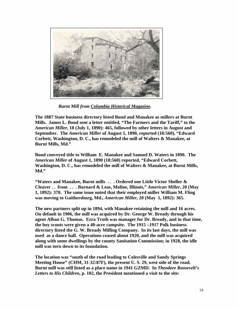
14
Burnt Mill from Columbia Historical Magazine. The 1887 State business directory listed Bond and Manakee as millers at Burnt Mills. James L. Bond sent a letter entitled, “The Farmers and the Tariff,” to the American Miller, 18 (July 1, 1890): 465, followed by other letters in August and September. The American Miller of August 1, 1890, reported (18:560), “Edward Corbett, Washington, D. C., has remodeled the mill of Walters & Manakee, at Burnt Mills, Md.” Bond conveyed title to William E. Manakee and Samuel D. Waters in 1890. The American Miller of August 1, 1890 (18:560) reported, “Edward Corbett, Washington, D. C., has remodeled the mill of Walters & Manakee, at Burnt Mills, Md.” “Waters and Manakee, Burnt mills . . . Ordered one Little Victor Sheller & Cleaver . . from . . . Barnard & Leas, Moline, Illinois,” American Miller, 20 (May 1, 1892): 370. The same issue noted that their employed miller William M. Fling was moving to Gaithersburg, Md., American Miller, 20 (May 1, 1892): 365. The new partners split up in 1894, with Manakee retaining the mill and 16 acres. On default in 1906, the mill was acquired by Dr. George W. Bready through his agent Alban G. Thomas. Ezra Troth was manager for Dr. Bready, and in that time, the boy scouts were given a 40-acre campsite. The 1915 –1917 Polk business directory listed the G. W. Bready Milling Company. In its last days, the mill was used as a dance hall. Operations ceased about 1920, and the mill was acquired along with some dwellings by the county Sanitation Commission; in 1928, the idle mill was torn down to its foundation. The location was “south of the road leading to Colesville and Sandy Springs Meeting House” (CHM, 31-32:87F), the present U. S. 29, west side of the road. Burnt mill was still listed as a place name in 1941 GZMD. In Theodore Roosevelt’s Letters to His Children, p. 102, the President mentioned a visit to the site:

15
White House June 21, 1904 Dear Ted: Mother and I had a most lovely ride the other day, way up beyond Sligo Creek to what is called North-west Branch, at Burnt Mills, where is a beautiful gorge, deep and narrow, with great boulders and even cliffs. Excepting Great Falls, it is the most beautiful place around here. Mother scrambled among the cliffs in her riding habit, very pretty and most interesting. The roads were good and some of the scenery really beautiful. We were gone four hours, half an hour being occupied with the scrambling in the gorge. “The History and Construction of the Mill at Burnt Mills, Md.,” an initiation thesis, January 16, 1931, by John Rogers Beall, is preserved in the McKeldin Library, College Park. Rogers measured the portions of the mill then standing. He found a metal stencil marked “Glen Cairn Mills” and observed the name of the builder “Klopopmeyer” and the date 1911 inscribed in the concrete flume that had replaced the mill race. Neighbors reported that the roller process was installed in 1895, allowing production of three grades of flour. The old ditched mill race had drawn water from Gum Spring and from Northwest Branch. A 19th Century plat in Liber JA 42:109 showed the mill as a single rectangle. The mill was considerably expanded to accommodate the roller equipment. Beall’s measurements showed two frame sections 41 x 37 feet and about 30 x 26 feet, separated by an 11-foot space through which the turbine penstock passed (p. 8). There was a 17-foot drop from the floor of the flume to the turbine. By then, the turbine was rusted, but its housing was about 3 ft in diameter. There were 10 double stands of rolls in the mill. One run of burrs was retained for meal. This thesis contained elaborate data on gearing, numerous detail photos, and a sketch of the wooden-toothed gear. Photos of the mill showed a frame and clapboard structure of 3-½ stories with a long clerestory. See also, Eleanor M. V. Cook, “The Story of Burnt Mills,” The Montgomery County Story, 35 (November 1992): 225-235. BURRIS PAPER MILL (10) Mrs. Burris Old Paper Mill was shown on the north side of River Road at Cabin Creek in the 1865 Martenet county map. Same as Magruders Mill, q. v. BUXTON MILL (9) See Middlebrook Mill.

16
CABIN JOHN MILLS (7) Cabin John post office was established 1818-1819; the name is a corruption of Captain John’s. William Willson and Andrew Way, Jr., advertised Cabin John Mills as three stories, 40 x 60 feet, with two pair of first-rate burr and 40 to 70 bbl/diem maximum output in flour; also a good miller’s house, National Intelligencer, May 1, 1823, p. 2. CASTOR OIL MILL (8) Geographical Description of Md. And Del., listed 1 castor oil mill with an annual output of 500 bottles; in 1807 it was at the west end of Brookeville. CHANDLEE MILL (8) CHANDLEE MILL ROAD This mill, also called Riverton, was near Sandy Spring on the Brothers Content tract, or Dellabrooke, presumably the successor of James Brooke’s mill. It was built by Mahlon Janney Chandlee, a Quaker and a native of Kennett Square, Pa., some time after 1817 when he took over the original Brooke Mill, HMCM, p. 138. Mahlon Chandlee (a member of Sandy Springs Friends Meeting House) sawed the wooden benches and roof beams for the meeting house at his water-powered mill in 1817 per Sandy Springs Waking Tour, n. p. In 1818, Joshua Peirce and Mahlon Chandlee agreed to sell Great Meadow, 840 acres, to Ephraim and John Etchison. In 1829, the survivor, John Etchison, was sued for payment and the tracts were ordered sold. All interest of John Etchison in a grist and saw mill on Great Meadows was advertised in the Frederick-Town Herald, October 10, 1829, and Reuben Warfield bought lot No. 1 in 1830 (Chancery Papers No. 8016 and Liber B140:120ff, MSA.). J. T. Ductel, State Geologist, mentioned Etchison’s Mill near Triadelphia in his Annual Report, December 26, 1837. John H. Alexander’s 1837 map of Mongtomery County showed Etchison’s Mill 4 miles due east of Damascus, which would be the distance to Duvall Mill on Annapolis Road. John J. Albert’s 1838 canal map showed the Chandlee Mill on Annapolis Rock Road, south bank of the Patuxent, Hammond Harwood House Atlas, figure 76. Mahlon Chandlee had been a remarkably strong man, 6 feet tall, and died when he fell out of a tree he was climbing at the age of 99-½, OBGF, pp. 279, 281. The miler’s house is illustrated on p. 280. Chandlees Mill was shown in the atlas on a branch about 0.5 mile from its confluence with Hawlings River; the west side of present Route Md. 116, 0.15 mile north of the bridge over Hawlings River.

17
The 1880 census listed Henry Chandlee mill on Hawlings River with $1650 investment; a 20-foot fall drove a 20 hp overshot wheel 4 ft broad at 15 rpm. The sawmill had 1 employee, 1 circular saw and 1 Muley saw; output was 30,000 ft ($550) in a 1-month season. The gristmill had 1 employee, 1 run of stones, and 60 bu/diem maximum capacity; annual output was 148.5 toms meal and 5.5 tons feed ($3850). Chandlees Road survives [1976]. According to a member of the Montgomery County Historical Society, James Brook has a son, Roger Brook, who moved to Brooke Grove and had a mill for home use. That lady remembered the Chandlee Mill as three stories, and she scampered around it when a child; the mill wheel seemed to be saying, “Better skip, the Devil catch you; Better skip, the Devil catch you.” The mill had an overshot wheel and a large head race and long tail race. In 2000, the Chandlee Mill Road lead from Md. 108 to Gold Mine Road without any sign of a mill or ruin. In 2000, the Sandy Spring Museum had a sign stating that the mill was at the foot of Walnut Hill near New Hampshire Avenue, and Rivermist Kennel was on or near the site of the mill. CHANDLEE MILL (8) Gaynor Chandlee, wife of George Chandlee at Black Meadows, Sandy Spring, wrote “The Storm of 1799,” on May 26 of that year, “Cousin Joseph Elgar was obliged to climb in the beams of the saw mill as near the roof as possible, not having warning sufficient to get even across the road for better shelter, when the one he had tottered so that he expected every moment it would go,” copied from family notebook of Mrs. Henry F. Fitzhugh, 1980. George Chandly [sic] advertised a new gristmill on Patuxent River between Green and Snell’s bridges, Federal Gazette, September 18, 1801. An ad in both English and German) in Bartgis Republican Gazette, January 21, 1803, listed 1 pair of stones. Chandlee’s wife had inherited one of James Brooke’s mills in 1770. His son, Mahlon, built another Chandlee Mill on a different stream. CHENEY MILL (4) Same as Walter Bealls. CISSEL MILL (5) The 1850 census of manufactures listed James Cissel with $1500 capital investment in a water mill with 2 employees and annual output of 1980 bu meal and 50,000 ft lumber ($2100). CLAGETT MILL (9)

18
The late David Clagett’s property, part of Brothers Industry and of Clagetts Folly, was advertised for sale along with a grist and water mill, Md. Journal, Rockville, July 31, 1844. CLARK MILL (8) The atlas showed the old mill of John O. Clark on the Hawlings River NE of Brookeville. CLEMENTS SAWMILL ( ) The following sign was located on the west side of Md. 27 (Ridge Road) south of Ridgeville, 0.8 mile north of Windsor Forest Road in Montgomery County: CLEMENTS & SON’S LUMBER MILL Specialty railroad ties. Lumber cut to order. Walnut, cherry, etc. Sawdust. Will buy Standing timber and logs. Wholesale and Retail. Tel: 829-2257 Sign copied August 1, 1978, by Claire A. Richardson, who did not see a mill nearby. CLOPPER MILL (9) The ruins of Cloppers Mill survive south of Clopper Road (Md. 355) on the west bank of Great Seneca Creek [1976]. In 1779, the court ordered a “road from Muddy Branch to Benjamin Edward’s from above Thomas Pack’s plantation and by the south side of the Quince Orchard hill to the old road through Abraham Holland’s plantation and with the old road to a road through Abraham Holland’s lane and with that lane to Zachariah Maccubbbin’s mill,” Pat Melville, “Roads in Montgomery County, 1777-1794,” The Atchivists’ Bulldog, 18 (September 15, 2004): 3. Zachariah McKubin (or Maccubbin) contracted to buy the tract “Good Port” from William Benson, ca. 1784; he tore down the decayed Benson Mill and built a new mill which did not appear on the 1794-1795 Griffith map. In 1805, there was an act of the general Assembly to open “a road from Barnesville to Maccubbins’ mill, to intersect the main road leading from Frederick Town to Georgetown at or near Logtown,” HWM,. 1:656. McKubin had never completed payment nor received title to the land from William Benson, who had died intestate in 1790. Benson’s heirs in 1804 complained that Maccubin was cutting down the timber and later they initiated an ejectment suit. McKubin got a temporary injunction but was ultimately ejected. Henry Howard of John, Trustee of the Bensons, advertised the mill in the Federal Gazette, September 2, 1807; it was 38 x 42 feet, three stories, one of stone,

19
two of brick, two water wheels, 3 pair of stones, 2 of French burr, one of Collins; merchant and country bolting cloths, sawmill, smith’s shop, dwelling, store house, and 488 acres. Maccubin complained to the Court of Chancery that the Bensons were trying to both force him to pay for the land and simultaneously take it away from him, and they had “most cruelly swept away all the horses, stock, corn, wheat . . . Threatening to turn him and his family out of door in poverty and distress,” Chancery Papers, No. 543 and 3462, MSA. In 1810, some of the Benson heirs conveyed their share of the mill and 50 acres to Allen Simpson, husband of a Benson, Liber P. f. 107. The road to Simpson’s Mill was mentioned in deeds of 1811 and 1818, but by then, Simpson had already mortgaged a 2/3 share to William Benson and Richard Ricketts, Liber 9 f. 112f, 544. In March 1812, William Benson, Ninia Benson, Allen and Sarah Simpson sold Goodport, Locust Thicket, and Seneca Hills (541 aces) to Francis Cassatt Clopper for $7000, Liber P, f. 541. F. C. Clopper, born in Baltimore in 1786, had been reared in Philadelphia, where he married Anne Byrne. The diary of Archbishop Ambrose Marechal, October 9, 1823, recorded, “Dined at Mr. Warner’s with Mr. Clopper, a rich miller whose wife and children are Catholics . . . , ” Records of the American Catholic Historical Society, 11:441. By 1826, the name Woodland Mills appears in deeds to designate the McKubin-Simpson-Clopper Clopper Mill from Postcard Clopper Mill Ruins Mill. Not explained is a stone in the mill wall marked “F. C. C. 1834.” Possibly, Clopper had to rebuild after some disaster in 1834. Clopper Mill was shown on J. H. Alexander’s 1837 map of Montgomery County. Jane C. Sween et al, in Montgomery County, 1999, p. 54, noted that Francis C. Clopper was trying to bring the railroad to his county.

20
Clopper also acquired the Faw-Lingan-Middlebrook Mill and considerable property including some Potomac islands. He was a public-spirited citizen, stumping in favor of Henry Clay in 1844, contributing the lot for Saint Rose Church adjoining his property in 1847, and having his portrait done by Sully. Clopper, a cousin of Mary Cassatt, designed the Rockville Courthouse. At one point he deeded all his property to his brother-in-law and sister-in-law, Patrick J. Byrne and Ellen M. Maher, to hold in trust for his wife; all that land eventually passed to his daughter, Mary Augusta Clopper Hutton. In 1831, Clopper took the legacy left by Patrick Byrne (d. 1829) for the Clopper children and invested it in land that came to be called Factory Farm, possibly the site of the Clopper blanket factory mentioned in HMCM, p. 28f. See also, Clopper Woolen Manufactory. Charles Mansfield announced in the Rockville Sentinel, May 8, 1857, that he was removing from the F. C. Clopper Mill and wished his creditors would settle with him. Richard H. Bennett advertised wool carding at Woodland Mills, Ibid., May 28, 1858; he had made arrangements with Mr. F. C. Clopper to put his carding machines in order. In 1863, Clopper deeded Goodport and the mill to his daughter, Mary Augusta Hutton, but retained a life interest for himself and his daughter Ellen M. Clopper, who was to receive half of the “tolls of the mill and mill seat . . . Including the tenements now on the right bamk of the mill race,” Liber JHG No. 9, f. 292. The mill and sawmill (but no woolen works) appeared on the 1865 Martenet county map. George Atzerodt, the accomplice of John Wilkes Booth, put up with the tenant miller, Robert Kindler, at Clopper’s on the night of April 15, 1865, William A. Tidwell, Come Retribution, p. 433. Clopper died December 30, 1868, at age 82. His inventory included 1 corn crusher, 1 press screw and frame, 1 cider mill, 7 carding machines, and 3 looms, Inventories, RWC No. 4, f. 246. The atlas of 1879 showed the Woodland Grist and Sawmill plus W. R. (William Rich Hutton) Sawmill on the south side of Clopper Road near Clopper Station. Longdraught Road of the present was once called the “Mill road” or the “Road to Huttons Mill.” W. R. Hutton lived on the side of Clopper Road opposite the gristmill, per the 1879 atlas, and J. W. Kinney was occupant of F. C. Clopper’s original mansion, Woodlands, on the south side. Hutton had accompanied the U. S. Volunteer expedition to California during the Mexican War, and 95 sketches he made of the campaign are in the Huntington Library, San Marino. He panned just enough gold at Sutter’s Mill to make his wife’s wedding ring. Hutton was a civil engineer by profession, but kept up with the property by mail. The last hired

21
millers were Barton Trail and William Jones. The American Miller of June 1, 1891 (19:414) reported that B. Trail, miller at Cloppers, Md., had died. The mills stood until 1947, when burned down by an incendiary. The mill ruins, more extensive than in 1971, were shown in Living in Montgomery County, Md. State Department of Education, 15:08. The property passed to W. R. Hutton’s descendants and in 1955 was deeded by them to the State for inclusion in the Clopper area of Seneca Creek Park, Liber 2035, f. 133. A millstone survived in 1968. A photograph of the Cloppers Mill ruins by Jay S. Hollis was published in Historic Preservation, January-March 1977, p. 11. A photo of the intact mill from the collection of Idella Leaman was published 1984 in Pictorial History of Montgomery County, pp. 24-25. Another view in Sween, et al., Montgomery County, 1999, p. 54. See also, Doris Cobb, “Mills on the Seneca,” ms. in Montgomery County Historical Society, 1968, p. 9f. The Courier, Damascus, February 23, 1967. CLOPPER WOOLEN MANUFACTORY (6) The 1850 census listed Francis C. Clopper Woolen Manufactory as capitalized at $8000, powered by water, with 7 employees, and a monthly payroll of $125. The works was equipped with 7 cards, 3 looms, 2 fulling stocks, 2 pickers, 2 spinning frames. Output was 9000 yards of rolls ($4050), 3600 yards of cloth casinets, linsey, flannel, etc. ($2700), and cloths fulled and dressed ($250). The factory consumed 10,000 yards of carded wool, 2000 yards of manufactured wool, 300 gallons of oil, and 500 yards of cotton chain, total cost of $4230. It was mentioned in HMCM, p. 328f, that F. C. Clopper manufactured blankets during the Civil War. The 7 carding machines and 3 looms were listed in his inventory (RWC 4:246). Family tradition has held that the woolen works was a separate location from the Clopper Mill, which is listed as a separate enterprise in the census. While it is true that wool carding was offered at Woodland Mill (Sentinel, May 28, 1858), evidence suggests that the wool factory was on Longdraught Branch west of Longdraught Road. Thee is a well defined mill race leading in from the east to the ruins of a mill, now in State Park property, but originally on the tract called Martha and Mary; the site had belonged to the Clopper family or its branches from 1832-1955. The Longdraught site came into the family by Mrs. Ellen M. Maher’s purchase from Willy James, trustee of Benjamin Williams, deceased. Owners prior to Williams had been members of the Sybert, West, and Riley families. There are no known references to mills operated by thosee families or by Mrs. Maher or by her niece, Mary Augusta (Clopper) Hutton, who inherited the property in 1858 and

22
gained complete control in 1867 (EPB 4:299). The mill does not appear on the 1794-1795 or 1865 maps, nor can it be positively identified with a small building symbol on the 6th district map in the 1879 county atlas. The Martha and Mary tract adjoined another Clopper family property known as Factory Farm, acquired by F. C. Clopper family in 1831 as an investment in real estate for his children. The Factory Farm was probably merged with Martha and Mary, and the name appeared in only one deed. Longdraught Road is referred to as “the Mill Road” in Plat Book 1, f. 3 (1894) and “the public road leading to Hutton’s Mill,” in a deed of 1897 (JA 58:221). However, Hutton’s Mill could also be interpreted as the original McKubin-Clopper-Woodlands Mill on Great Seneca Creek and Clopper Road, which could be reached by turning left at the end of present Longdraught Road. There are no references to mills operated by prior owners of the tracts “Quince Orchard” and “Gibson’s Choice” that came to be called Factory Farm--tracts that had passed through the owners Luther Owens and Joseph McKinstry, Notley Trail, and members of the Holland family. By 1910, when Mrs. Mary Augusta Hutton made her will, the property south of Longdraught Branch was described as farm land and pinewoods, and there are no references to Factory Farm, Quince Orchard, or Gibsons Choice, which seems to have been merged into Martha and Mary in the family’s description (Wills HCA 14:455). A preliminary archaeological excavation was performed here in May 1971 under supervision of State Archaeologist, Tyler Bastian. The water power of Longdraught was placed at 50 feet by Scharf in HWM, p. 646. The Seneca Trail web site available in 2006 stated that there was a stone foundation and mill race intact on Long Branch but currently under Lake Clopper on part of the Martha and Mary tract CLOUD MILLL ( ) See Frizzell Mill. COOMES TANNERY (1) The 1850 census listed Joseph R. Coomes 11-vat tannery with $200 capital investment, 2 employees, and annual output of 500 sides leather and 36 calf skins ($1165). COONCE MILL ( ) Mentioned in 1777/78 roads document. COOPER MILL (10)

23
Jonathan Cooper was listed as miller at Offutts X Roads, 1871 Drysdale State Gazetteer; the village is now Potomac. CROSS CIDER MILL ( ) Bob Allen reported on the Cider Barrel on Md. 355 at Germantown in, “Cross Family’s Cider: A Pressing Business,” Sun Magazine, November 15, 1987, p. 9. CROWS MILL (1) Crows Mill was shown on a branch of Great Seneca Creek, 6 miles west of Unity on Dennis Griffith’s 1794-1795 map. On January 1, 1795, Edward Crow advertised Goshen Mills on a public road that leads from the mouth of Monocacy to Baltimore town . . . 27 miles from George Town . . . 36-foot fall “which is so calculated as to use that water, a second time; there being two Mill Houses, one above the other, viz. a Brick House three stories high, 36 feet by 25, almost new; the other a framed house, 24 feet square, the whole intended to work four pair of stones, three of which are now running (two Burrs, the others Cullans) . . . Materials for a Saw-Mill . . . 150 acres . . . A rich Copper Mine . . . Dwelling . . . Miller’s house,” Md. Journal, Baltimore. The Rev. Ignatius Pigman had sold to Edward Crowe the tracts Land of Goshen, Pigmans Purchase, Resurvey of Benjamins Square, and Fertile Meadows, “Including the Mill Race . . . Excluding 1 acre of Goshen Church,” MCLR Liber G:301. Sale price was £ 1350, September 1796. Crow sold the Goshen Farm and Fertile Meadows to Samuel Robertson in 1809; those parcels passed to George Washington Riggs, 1819. Goshen Mill on Seneca Creek was shown on J. H. Alexander’s 1837 map of Montgomery County. The mill passed to Remus Dorsey Riggs by devise, 1862, HMCM, p. 163f. A stamped cover postmarked April 17, 1862, was displayed in September 1980 at the BALPEX stamp show at Hunt Valley, a letter mailed from Hoods Mills to “Dr. Washington Waters/Goshen Mills”--although Dr. Waters did not own Goshen Mill. Remus D. Riggs died in 1867, Ibid., p. 252. The atlas of 1879 showed Remus Riggs grist and saw mill on Goshen Branch. There was a Goshen Mills Post Office which was changed to Cracklintown July 1848 and to Laytonsville in August 1848. The Cumberland Sunday Civilian of August 23, 1890, reported, “Goshen Mills Burned” on the morning of the 27th, the property of R. D Riggs. G. W. Moxley was miller. Loss was $5000. The mill had not been running for 30 hours. The American Miller of January 1, 1891 (19:55) reported that R. D. Riggs was placing Case Rolls in his mill at Gaithersburg, Md. The same journal on February 1, 1891, stated that R. D. Riggs would improve his mill at Gaithersburg (19:130). The American Miller of April 1, 1891, stated that R. D. Riggs mill at Goshen burned on March 10 with a loss

24
of $6,000, the result of arson; this was Riggs’ second disastrous fire. The Manufactures Record reported the fire story on March 21, 1891, and placed the mill at Goshen (19:40). The Baltimore Sun reported on March 11, 1891: “New Roller Mill Destroyed. Goshen, MD. -- March 10. The new roller mill of R. D. Riggs, at Goshen, Montgomery county, as well as his new sawmill, was totally destroyed by fire early this forenoon. The fire was the work of an incendiary. The estimated value of the mill was six thousand dollars and the insurance only a carpenter’s risk in the Baltimore County Company. The mill was burned last summer and was replaced by a first-class mill, with the latest improved machinery. It would have been in operation in a few weeks. The fire was discovered shortly after it had been started, and efforts were made to put it out, but they were unavailing. The Manufacturers Record of July 1, 1891 (19:488) stated that Riggs would rebuild and use roller machinery. The millstones are now steps at Fertile Meadows [1976]. [Not related to Crow Mill Ford in P. G. County.] The R. D. Riggs mill near Laytonsville had been set afire twice by arsonists, Baltimore American, September 4, 1891, p. 6. CROWE MILL (12) Edward Crowe acquired the Pigman Mill on the Patuxent. This became Mullinix Mill and was distinct from the Crows Mill on Great Seneca Creek in 1795. Also mentioned in 1808, HWM, 1:656. DAMASCUS ROLLER MILL ( ) A model of “Damascus Roller Mill” operated by King, Waters, and Burdettes, was made by Genoa King and displayed at the Hyattstown Mill, May 31, 1997. DARBY MILL (2) See Hyattstown Mill for G. A. Darby. DARBY MILL (2) The 1850 census listed Aden Darby’s water mill worth $1200 with 1 employee, 1 run of stones, and annual output of 2200 bu meal ($1320). DARBY MILL (1) Samuel T. Darby of Laytonsville was listed as an atlas patron and miller of “Oakland Grist and Sawmill” on Great Seneca Creek. The 1865 Martenet county

25
map had shown William A. Darby’s mill NW of present Md. 124. Also mentioned in HWM, p. 648. DARBY MILL (11) The 1865 map and the 1879 atlas showed John W. Darby’s grist and saw mill on Bucklodge Branch near Boyds Station, 0.25 mile south of the railroad. Bradstreet’s 1867 directory listed John Darby & Son as millers at Seneca Mills Post Office. James W. Darby was listed at Germantown in the 1871 Drysdale State Gazetteer. The 1880 census of manufactures listed the James Darby custom mill worth $4000 with 1 employee, 2 run of stones, 40 bu/diem maximum capacity. A 13-foot fall (on Bucklodge) drove a 10 hp overshot wheel 8 ft broad at 9 rpm. Output was 220 bbl flour, 108 tons meal, and 1.1 tons feed annually ($3872). A mill race was reported in 1977, north of the B. & O. Railroad and parallel to and east of Bucklodge Branch on the Hough property. Mill was apparently extinct at that time. The on-line information available in 2006 from Seneca Trails called this the successor of Ninian Beall of Ninian’s mill; later owned by Edmund Jennings (1783 tax list). The second mill was owned by George Viley, then Nathan S. White, Benjamin White, John White, John W. Darby. “The mill run is still in very good condition with only a few breeches along its ¼ to 1/3 of a mile length. The start of the mill run is at the base of the railroad track bank. A stone culvert which fed into the mill run exists under the bank. It is currently filled in. At the other end of the mill run there is no evidence of the mill. The tail run going back to Bucklodge Branch is also easy to see. The ruins of structures shown in the 1879 atlas are located in a nearby field.” This web site called the site “Wolfs Cow Mill.“ DARBY MILL (6) See Seneca Creek Mill. DAVIS MILL (2) DAVIS MILL ROAD See Washington Waters Mill (on Wildcat Branch). DAVIS MILL ( ) Ignatius Davis advertised 100 acres and mills in Montgomry County on New Cut Road from the mouth of Monocacy to Baltimore [and also a mill in Frederick County owned in common with Thomas Morton], Frederick-Town Herald, February 25, 1804, quoted in MMG 2:34. DAVIS MILL (8) The 1850 census of manufactures showed Allen B. Davis with $2500 capital investment in a water mil with 2 employees and annual output of 1100 bu meal,

26
25,000 ft lumber, and 150 bu clover seed ($1670). The 1865 Martenet county map showed it as a steam mill on the south bank of Hawlings River. Allen Bowie Davis was mentioned in the election district boundaries of 1878 as on the Westminster Road and Hawlings River, HWM, p. 768. The road is now designated Md. 582 or Hobbs Road. Allen Bowie Davis owned the 3000-acre Greenwood estate and had both the home mill and the “Howard County Mill” or the Roxbury Mill [now extinct]. He owned 100 slaves and when he read them the proclamation that they were free, some ran away while others merely went back to work. William Johnson, the miller and blacksmith remained loyal to Davis; however, one of the milkmaids died from the excitement of emancipation. Davis sold off much of the plantation and the two mills, HMCM, p. 179f. Monumental City presented a biography of Davis, p. 648. DAVIS MILL (2) See Pyles Mill for the Davis or Plummer Mill near Boyds. DAWES MILL ( 5 ) Dennis Griffith’s 1794-1795 map showed the E. Thomas Mill on the east bank of North West Branch, the only mill on the stream, 2 miles from the P. G. County line. It was not far enough upstream to equate with the Burnt Mill. A sale advertisement offered land near Colesville, “reserving to Edward Dawes the right to a millrace as described in a deed from Richard Smith and others to John Poole, August 15, 1842,” Md. Journal, Rockville, November 19, 1845. The mill was still standing and reserved to Dawes in a deed made in 1845, Liber BS No. 11:262. The site was presumably north of present Md. 138 and on the North West Branch, west of Colesville, possibly the same as Kemp Mill. The 1850 census of manufactures listed Edward Dawes bone and saw mill with $1500 capital investment, with four employees, water power, and output of 4800 bu bone dust and 70,000 ft lumber ($3744). George Kemp advertised in the Sentinel, March 20, 1857, that he was “unable to carry on because of delicate health” and offered to sell the mill. The 1865 Martenet county map showed the grist and saw mill of Mrs. S. Kemp on the east side of road at Northwest Branch SW of Colesville. James H. Zeigler was an atlas patron in 1879 and owned the “Northwest Grist & Saw Mill on Northwest Branch. The 1880 census of manufacturers showed Zeigler with $1245 capital investment, 1 employee, 1 circular saw and 1 Muley saw. A fall of 11 feet drove an 18 hp overshot wheel 4 ft broad at 20 rpm. Output was 50,000 ft ($1030). The gristmill had $2000 capital investment, 2 employees, 3 run of stones,

27
100 bu/diem maximum capacity; 66% of the business was custom. A 14-foot fall drove a 20 hp overshot wheel, 5 ft broad at 20 rpm. Annual output was 700 bbl flour, 7 bbl rye, 167 tons meal, 27.7 tons feed, 4 tons buckwheat ($10,176). Zeigler was also in the 1880 State business directory. DAWSON MILL (3) The 1850 census of manufactures listed Joseph N. Dawson’s mill with $1500 capital investment, 1 employee, 1 run of stones, and 1 saw. Output was 4000 bu meal and 20,000 ft lumber annually ($2700). The 1865 Martenet county map showed Joseph Dawson’s grist and saw mill on Dry Seneca Creek east of Poolesville, at the NW corner of the creek and the present Sugarland Road. The 1880 census listed Frederick (A.) Dawson mill at the same value as in 1850, with production down to $1347. One-eighth of the business was custom. Now equipped with 3 run of stones, the 75 bu/diem mill was driven by a 15-foot fall on Dry Seneca that turned a 10 hp overshot wheel 4 ft broad at 50 rpm. A web site posted by Seneca Trails reported in 2006 that “the remains of the mill are about 10 feet from Sugarland Road on the north west corner of where it crosses Dry Seneca Creek. Two walls of the foundation are visible. The other walls have been destroyed by the nearby culvert or are not visible due to the heavy growth of multi-flora rose. The mill run is about 10 feet above the level of the creek and follows the contours of the bank until it meets the creek about a quarter of a mile away.” DAWSON SAWMILL (9) A. Dawson was listed as saw miller at Germantown in the 1887 State business directory. DAY SAWMILL (12) Same as Kellers Sawmill. DEAKINS MILL (2/12) Francis Deakins appeared on the 1783 tax list of Linganore and Sugar Loaf Hundreds with Welfare and a good gristmill, large stone mill house, and granary 32 miles from Georgetown. DEAKINS MILL (6) Deakins Mill was mentioned in a roads authorization of 1777-78. William Deakins, Jun., and Bernard O’Neill advertised a gristmill at the mouth of Seneca Creek, Md. Journal, Baltimore, October 8, 1785.

28
The court in 1779 ordered a road from the east side of Jacobs Bridge to the Sugarland Road leading from O’Neill & Deakins Mill on Seneca Creek, Pat Melville, “Roads in Montgomery County, 1777-1794,” The Archivists’ Bulldog, 18 (September 15, 2004): 3. DELPHI MILL ( ) A letter from Major General A. McD. McCook written at Fort Stevens, July 12, 1864, reported to General Auger, “Captain Hotopp, Eight Illinois Cavalry, reports the enemy has withdrawn his pickets on the Delphi Mill road and Davis road and appears to be falling back on the Rockville road. His impression is they are either going toward Georgetown or Rockville,” Official Records of the War of the Rebellion, I, 37:230 (Part II). DENTS MILL ( ) An 1777 document described a route “from the Mill Branch to George Robinsons Bridge on the road that leads from William Beckwith’s to Dents Mill.” The court in 1779 ordered a road from the Mill Branch to George Robertson’s Bridge and from William Beckwith’s Plantation to Dent’s Mill,” Pat Melville, “Roads in Montgomery County, 1777-1794,” The Archivists’ Bulldog, 18 (September 15, 2004): 3. DERWOOD MILL (9) “The Gaithersburg Milling and Manufacturing Company has bought the ‘Lyddane Mill’ at Derwood, Md., of Cooke D. Luckett for $10,000, and will take possession January 1,” American Miller, 20 (December 1, 1892): 902. Cooke D. Luckett of Rockville advertised to sell a “Maryland Steam Mill” saying, “Will sell steam flour mill and meal mill near Washington, D. C., and in finest section of Maryland, 80-horse power Corliss Engine; four story high; roller process; 100 barrels flour, 50 barrels meal, and 200 barrels chop per day. At station on metropolitan B. & O. R. R., main route west, from national capital, which is 17 miles distant. Dwelling, warehouse, stables, 3-½ acres of land etc. Good reason for selling at a sacrifice on easy terms.” American Miller, 20 (December 1, 1892): 888. “The mill at Derwood, Md., has been placed in operation after a short period of idleness. The mill was bought some time ago of Lyddane, Jones & Co. by the Gaithersburg Milling and Manufacturing Co,” American Miller, 21 (March 1, 1893): 226. “The ‘Derwood Mills’ at Derwood, Md., are being remodeled with 100 barrels’ daily capacity. The contract has been awarded to Aug. Wolf & Co., of Chambersburg, Pa.,” American Miller, 21 (June 1, 1893): 538. The same journal of July 1 1893 (21:538) stated that the maximum capacity would be 120 barrels per day.

29
In the 1920s and 1930s this mill produced “pure corn molasses” and also Derwood Hog and Pig Meal, The Sentinel, undated clipping. DEVILBISS MILL (3) J. A. Devilbiss was listed as miller at Martinsburg in 1880, HMC. DEVIL’S DEN MILL SITE ( 5 ) Harry Shannon, who wrote as “The Rambler” in the Washington Sunday Star, reported on October 4, 1914, that he had explored Paint Branch, where he saw a water tunnel that had apparently been burrowed through a rocky outcrop for a mill that was never built. The tunnel was drilled and blasted by a slave offered his freedom if he finished; the project lasted so long that the workman finished it as a free man on his former master‘s payroll. The Rambler described the place as a den of snakes. This site was off limits to the public while owned by the Naval Ordnance Laboratory at White Oak. In 2000, when the Navy was giving up the site, Elizabeth Anderson Comer of EAC Archaeology investigated the site along with John McGrain on May 12 that year. The tunnel existed near Paint Branch and was being used as the nesting site of a vulture. The den is almost exactly a mile NE of the entrance to the NRL on New Hampshire Avenue (Route 650). It is difficult to see how this tunnel would channel water to do useful work; a large dam with flashboards might have been the way to do it. Maryann Sadue searched the title in May 2000 and determined that the parcel traced back to James and Mary Parker, who sold it to John Pilling and Alice Pilling in 1853. The 1853 deed specifically mentioned “a privilege to build a mill dam.” Thus, the Pillings held the property from pre-Civil War times through Emancipation and might conceivably match up with the tradition. See also, Barbara Ruben, “Folklore Describes Devil’s Den Cave; Now It’s Found,” Washington Post, August 12, 1999. Also, The Eyes of Paint Branch, “Devil’s Den Explored in Paint Branch Gorge, Cave May Represent Unique Piece of African American History,” Backyard Bulletin, Summer 1999. See also, Elizabeth A. Comer and Brian M. Lione, “Documentary Research of Devil’s Den 18 MO550, Federal Research Center at White Oak, Montgomery County, Maryland,” Prepared for General Services Administration, National Capital Region, Washington, D. C. (EAC Archaeology: Baltimore, 2000). DODGE MILL (3) The 1850 census of manufactures listed Edward P. Dodge water mill with $15,000 capital investment, 7 employees, 5 run of stones, and 1 saw. Annual output was

30
17,000 bbl flour, 22,600 bu offal, 30,000 ft lumber, and 125 tons ground plaster ($95,765). DOWNS MILL (8) William H. Downs, Brookeville, was an atlas patron and operator of a grist and saw mill, 1879. DOYLE MILL (1) William Doyle’s old gristmill was shown in the 1879 atlas between the Patuxent and Scott Branch. Possibly the Duvall Mill of the 1850 census or the Etchinson Mill on John H. Alexander’s 1837 map. DU FIEFS MILLL (6) DU FIEF MILL ROAD John Dufief, prop. of Glenwood Mills, offered to buy grain, Sentinel, May 22, 1857. It was also called Glenwood Mills on the 1865 Martenet county map. Du Fief had a wharf on the C. & O. Canal. The atlas showed John L. Du Fief, old gristmill, on Muddy Branch just above its confluence with Turkeyfoot Branch. The name was spelled Du Tirf in HWM, p. 761. An old account book showed that the mill was dismantled and the shingles, etc., were sold in 1863. It was rebuilt by M. Hays for John Derby and Son in 1866. The present Dufief Mill Road runs SW from Darnestown-Rockville Road. Charles Du Fief offered the mill and 147.7 acres for sale, Sentinel, February 27, 1880. The mill ruin is now within Muddy Branch Park near Turkey Cock Road, an identified archaeological site, with a surviving race still very pronounced. A large mound marks the mill ruin, “Darnestown/Travilah Historic Resources,” Montgomery County Planning Department, Silver Spring, Md., 1996. DUVALL MILL (1) The 1850 census of manufactures showed Basil Duvall of J. water mill with $1000 capital investment, 2 run of stones, and 1 employee. Annual output was 1980 bu meal and 20,000 ft lumber ($1240). Duvalls saw and grist mill was shown on both sides of the Patuxent, east of present Annapolis Rock-Ellicott Roads and partly in Howard County, on the 1865 Martenet county map. Apparently one Duvall mill was on each side of the river. The “old mill” shown as William Doyle’s in the 1879 Montgomery County atlas was the former Duvall property. It is not clear if this was the Etchinson Mill on J. H. Alexander’s 1837 map of Montgomery County, 4 miles due east of Damacus, but it was exactly 4 miles from Damascus. DUVALL MILL (4)

31
The 1850 census of manufactures listed Benjamin Duvall water mill with $1100 capital investment, 1 employee, 3 run of stones, 1 saw, and annual output of 1300 bu meal and 10,000 ft lumber ($950). DUVALL MILL (5) James Wilfong’s 1964 newspaper feature linked the Duvall or Valley mill to this tract; however, Michael F. Dwyer’s 1984 paper did not make that connection. Historian Dwyer traced the mill site back to Ninian Edmonston who patented a tract called Hamburgh in 1763 when this was still Frederick County--later deeds suggest that Edmonston had actually constructed a mill. Walter Beall bought the place in 1771 and three years later a “single-geared breast mill that goes by water, with a bolting cloth” was offered at public sale in 1774. That year, William Murdock bought the mill and sold in 1775 to Richard Sheckles, planter. In 1777, Sheckle sold to his son John, also a planter. John Shankle was in the 1783 tax list of Lower Newfoundland, Rock Creek and NW hundreds, with Hamburg Mill Seat and an old gristmill. Hamburg is the land grant name at the mill ruin. Peter Kemp, a Frederick County miller, bought the mill in 1793; the deed mentioned “lands above Ninian Edmonstons old mill.” Kemp had his land resurveyed into “Kemp’s Mill Seat,” and was supposedly the builder of the brick miller’s dwelling. This mill passed into the hands of Franklin A. Pilling, and the 1865 Martenet map showed Alice Pilling’s mill on the east side of present Md. 196 on the north or east bank of Paint Branch. Allen C. Clark wrote that Alice Pilling’s mill was on the east bank of of Paint Branch where the main road crossed, CHM, 31-32:108. The 1879 county atlas showed the Duvall mill north of present Beltsville Road on the east bank of Paint Branch. Absolom Beall and others petitioned for a new road in 1884 along the Colesvile to Columbia Pike Road. A quaint drawing of the mill appeared in Montgomery Deeds EPB 27:290. At that time, Paint Branch was flooding the road and occupying the same bed. The 1880 census of manufactures listed Franklin Pilings with $6000 capital investment, 3 employees, 3 run of stones, 180 bu/diem maximum capacity; 60% custom business. A 15-foot fall on Paint Branch drove a 25 hp turbine, 1 ft 11 inches broad at 254 rpm. Output was 189 tons meal and 7 tons feed ($4388) annually. Michael F. Dwyer discovered a handbill printed at the Sentinel office in Rockville advertising an auction of the Pilling Mill on June 8, 1886. It was described as the former Duvall’s Mill on Paint Branch and there were 22-¾ acres, a dwelling house, barn, corn house, carriage house, and a substantial frame mill, 28 x 33 feet, three and a half stories, the lower story of which was stone. “This mill was built in 1879, and fitted up with new and improved machinery, including a Poole & Hunt latest
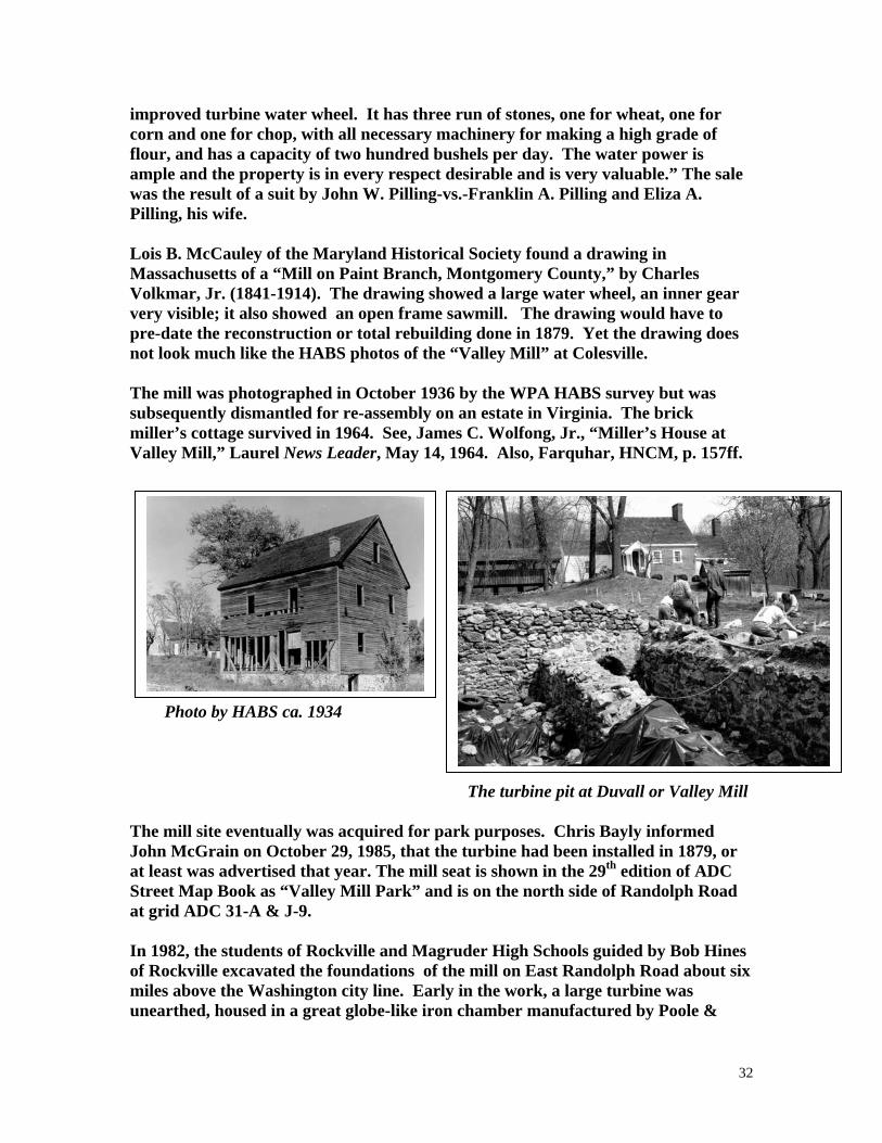
32
improved turbine water wheel. It has three run of stones, one for wheat, one for corn and one for chop, with all necessary machinery for making a high grade of flour, and has a capacity of two hundred bushels per day. The water power is ample and the property is in every respect desirable and is very valuable.” The sale was the result of a suit by John W. Pilling-vs.-Franklin A. Pilling and Eliza A. Pilling, his wife. Lois B. McCauley of the Maryland Historical Society found a drawing in Massachusetts of a “Mill on Paint Branch, Montgomery County,” by Charles Volkmar, Jr. (1841-1914). The drawing showed a large water wheel, an inner gear very visible; it also showed an open frame sawmill. The drawing would have to pre-date the reconstruction or total rebuilding done in 1879. Yet the drawing does not look much like the HABS photos of the “Valley Mill” at Colesville. The mill was photographed in October 1936 by the WPA HABS survey but was subsequently dismantled for re-assembly on an estate in Virginia. The brick miller’s cottage survived in 1964. See, James C. Wolfong, Jr., “Miller’s House at Valley Mill,” Laurel News Leader, May 14, 1964. Also, Farquhar, HNCM, p. 157ff. Photo by HABS ca. 1934 The turbine pit at Duvall or Valley Mill The mill site eventually was acquired for park purposes. Chris Bayly informed John McGrain on October 29, 1985, that the turbine had been installed in 1879, or at least was advertised that year. The mill seat is shown in the 29th edition of ADC Street Map Book as “Valley Mill Park” and is on the north side of Randolph Road at grid ADC 31-A & J-9. In 1982, the students of Rockville and Magruder High Schools guided by Bob Hines of Rockville excavated the foundations of the mill on East Randolph Road about six miles above the Washington city line. Early in the work, a large turbine was unearthed, housed in a great globe-like iron chamber manufactured by Poole &
33
Hunt of Baltimore. The device is similar to the turbine shown in Martha and Murray Zimiles’ 1973 book Early American Mills, p. 24. The miller’s cottage, an 18th Century brick house was nearby and in excellent condition. The mill race was spanned by a small covered bridge; daffodils were blooming in the dried up mill race. The Montgomery County Park Commission Department of Parks erected a “Valley Mill” sign that mentions Peter Kemp’s grist and saw mill of the 1790s,the 1835 mill built by Dr. Washington Duvall, and the 1897 mill built by Franklin Pilling that ran until the 1930s. See, Michael F. Dwyer, “The Valley Mill on the Paint Branch,” The Montgomery County Story. 28 (February 1985): 143-154. DUVALLS MILL (13) Newport Mills, the 7th mill on Rock Creek, was mentioned in 1780 in Md. Red Books, Calendar 679. Thomas Johns of Newport Mill offered $20 reward for the return of his Mulatto man Bob in 1789. See, Anthony Cohen “The Underground Railroad in Montgomery County, Maryland,” p. 2. The mill was at Kensington, just north of the B. & O. Railroad crossing over Rock Creek. It stood on the Duval tract, Hermitage, and appeared on Martenet’s 1865 county map as Dr. Washington Duvall’s. Duvall’s Mill on Rock Creek was shown on J. H. Alexander’s 1837 map of Montgomery County. Josiah Henson, the prototype of “Uncle Tom,” wrote in his memoirs that he was converted by the preaching of John McKenney at New Port Mill near Kensington, HMCM, p. 315. The 1850 census of manufactures valued Washington Duvall’s water mill at $3000, listing 1 employee and an annual output of 1100 bu meal ($5500) and 25,000 ft lumber ($437). It was also mentioned as on the B. & O. in the 1879 election district boundary description, MWM, p. 763. The mill was torn down “after the Civil War” per HMCM, p. 158. According to a letter sent to the county historical society by Mr. Wilson L. Townsend, January 23, 1968, he remembered seeing remnants of the mill about 1898 and stated that the location had been obscured by building the railroad. An historic marker for the Newport/Henson Mill stands in Rock Creek Stream Valley, at Ken-Gar Community Center, Knowles Avenue, Kensington. See, Margaret M. V. Cook, “New Port Mill,” The Montgomery County Story, 34 (February 1991): 151-146. DUVALL MILL ( ) Harry Shannon, “The Rambler,” who wrote about hiking trips in the Washington Sunday Star, noted on October 4, 1914, that he had visited Fassett’s Mill, other places spelled Fawsett’s Mill, “which stood about three miles further up the creek

34
and not far from Colesville. The Rambler was told that Reuben Baker owned the site at that time but “not a vestige of the mill remained.” EDMONSTON MILL (5) Same as Duvall’s, or Valley Mill. EDMONSTON MILL (1) C. T. Edmondston was an atlas patron listed under Rockville in District 4. The 1880 census of manufactures valued Charles T. Edminston [sic] mill at $200, listing 2 employees, 2 run of stones, 40 bu/diem maximum capacity, and 75% custom business. A 20-foot fall on Goshen Branch ran a 24 hp “water” wheel 4.5 ft broad at 5 rpm. Annual output was 120 bbl flour, 204.5 tons meal, 12.5 tons feed, and 1500 ln hominy ($4801). EDNOR MILL ROAD (8) This road near Brookeville was mentioned in the HABS Report for Maryland, p. 7. EISENGER MILL ( ) The Pictorial History of Montgomery County, 1984, p. 133, showed a photo from the collection of Malcolm Walters of a sawmill and planing mill in Bethesda in the 1920s. ELGARS MILL (4) The Third Mill on Rock Creek, Elgars was built about 1800, 500 yd below the site later used by Muncasters. It had a 20-foot wheel and used water from the same dam as Muncasters but was disassembled when Muncasters was built ca. 1800, HMCM, pp. 75, 215. ELGARS MILL (4) Joseph Elgar of Frederick County took out a writ of ad quod damnum on Rock Creek in the then Frederick County, February 19, 1863. The inquisition found the land part of the Resurvey on Bachelors Forest and in possession of Benjamin Beall, James Edmonson, heir of Archibald Edmonson, and James Beall, heir; yearly rent was set at 10 Shillings. The grant was issued 11 years later, December 6, 1775. Chancery Records, Liber 12, f. 26, MSA. This was apparently the mill listed as the 4th mill on Rock Creek in HMCM, p. 75. It was about a mile below the site later used by Muncaster Mill and on the lower part of Milton Farm. The mill was built by the “skillful millwright” Joseph Elgar, Sr. It was set on a rise of ground above a water fall 5 or 6 ft in height. The water

35
was guided to the underside of the wheel through a sluice. The wheel had 8 to 10 paddles about 2 feet long mounted on the hub, HMCM, pp. 75, 215. Elgar’s son, Joseph, Jr., founded a mill near Union Bridge in Carroll County. This Montgomery County mill closed before 1860. ELMES MILL (4) The 1850 census of manufactures listed James Elmes water mill with $3000 capital investment, 1 employee, 1 run of stones, 1 saw, and an annual output of 4000 bu meal and 60,000 ft lumber ($3300). ELTINGE MILL ( ) Spelling error for Ettinges Mill. ERBS MILLL ( ) Peter Erbs mill in Frederick County was mentioned in Md. Gazette, May 3, 1759. In 1786, Christopher Erb patented The Mill Seat, q. v. ETCHISON MILL (8) See (Mahlon) Chandlee Mill. [ ? ] ETTINGES MILL ( ) Isaac Ettinges Mill was at the terminus of a road segment from Cabin John in a roads document of 1779, HWM, p. 436. “Mill Road” was a 240-acre tract patented in 1739 by Cornelius Eltinge [sic], Liber LG No. C:52, MSA. There was a mention of Cornelius Etting [sic] and James Holdman’s mill dam across Rock Creek, 1750, in Frederick County Judgments. Also mention of a bridge at Eltinge’s Mill, see M. M. Rice, That Was the Life, pp. 66, 133. The Mill Road and “the Isaac Elting tracts” were mentioned in Chancery Records of 1790, Liber 19:476, MSA. This record repeated Randolph Elting’s will of 1755 wherein he left to his son Rudolphus instruction to dispose of the “land at Rock Creek where the Mills is on.” He left Mill Land to any posthumous child that might be born and left Milburn tract to Cornelius Eltinge. Another tract, Frog Land, at the mouth of Rock Creek, was within the present District of Columbia. C. E. Schildknecht placed the “Eltinge Mill” of Cornelius Eltinge in the Van Meter colony of Frederick County, about 1724. See Monocacy and Catoctin, pp. 123, 124, 127. ETTINGES MILL (6)

36
John Ettinge’s mill beyond Seneca Bridge was mentioned in a roads document of 1779, HWM, p. 436. FACTORY FIELD (6) See Clopper Woolen Manufactory. FAIRVIEW MILL (5) See Duvall Mill -----the Upper Duvall? FAIRLAND MILL (5) Same as Fawcetts. Also misspelled Fanland. FARMERS SAW AND GRIST MILL CO. (5) This works was listed at Spencerville in the 1867 Hawes Business Directory, p. 518. FAWCETTS WOOLEN MILL (5) The Fairview estate was later property of the Perry family, passing in 1809 to James Wilson Perry and later to his son-in-law, Dr. Washington Duvall. Laws of Md., Acts of 1809, Chapter 140, ordered a public road opened in P.G. County to review a private road now leading from Captain Thomas Richardson’s in P. G. County by the mill of John Chew Thomas on the Patuxent [sic] River until it intersects the post road from Baltimore to Washington, about one mill from the said mill.” Fanland [sic] Mills was an address given when John Chew Thomas and Isaac Tyson advertised for a miller on the Turnpike Road about midway between Baltimore and Washington, Baltimore American, August 12, 1814. Dr. Washington Duvall bought the mill from the Kemp heirs in 1835. Thomas Fawcett advertised that he “was now ready to card wool in either old or new style” at Colesville and also offered fulling and manufacture of woolens, Rockville Md. Journal, May 28, 1846. The Paint Branch Woolen Factory was announced as the firm of Thomas Fawcett and Son (Benjamin), Ibid., July 4, 1846. The road to Fawcett’s Mill was mentioned in an 1854 plat, JHG 3:108. The 1850 census showed Thomas Fawcett with $4000 capital investment in a woolen factory with 12 male and 3 female employees; water-powered production; 200 spindles, 10 looms, 8 carding machines. Annual output was 20,000 yd of servant’s clothing, 2000 yd flannel, and 40 pair of blankets ($10,960).

37
Benjamin Fawcett announced his purchase of T. Fawcett and Sons, Sentinel, May 31, 1856. He announced partnership with Joseph Fawcett, Ibid., June 26, 1857, providing cloths, linseys, blankets, and more “servant clothing.” Also listed by J. L. Bishop in HAM, 3:556 and CHM 31-32:107f. The Thomas Fawcett Woolen Factory was shown south of the present Fairfield Road on the west side of Paint Branch and upstream of Duvall Mill on the 1865 Martenet county map. Also shown in county atlas of 1879. By 1871, Joseph Fawcett was operating on his own. Harry Shannon writing as “The Rambler” in the Washington Sunday Star, October 1914, spelled the name Fassett and said the mill “stood about three miles farther up the creek and was not far from Colesville. The Rambler was told that Reuben Baker was the owner at that time, “but not a vestige of the mill remained.” Park Historian Michael F. Dwyer equated Fawcett with the upper mill of Dr. Duvall.” FAWS MILL (9) See Middlebrook Mill. FLING MILL ( ) William M. Fling of Gaithersburg wrote that milling was dull, the farmers not willing to sell wheat at 58 cents, American Miller, 22 (January 1, 1894): 45. FORDS MILL (2) Fords Mill was shown on John J. Albert’s 1838 map for a cross-Maryland canal. Located on Wildcat Branch on present Davis Mill Road. Possibly the Washington Waters Mill. FORGE (2) One forge was listed for Clarksburg in 1807, Geographical Description of Md. and Del., p. 141. Possibly the Howard’s Tilting Forge of 1783. FRALEY MILL ( ) Fraley’s Mill was engine-powered, located on Md. 108 between Olney and Laytonsville and ran from about 1880 to 1930s or 1940s. Ernest Fraley was operator about 1918, later used the mill as a truck depot. In 2001, this 30 x 40 foot building of post and beam construction, 38 feet high, was relocated at Riverton on Gold Mine Road on the property of Tim and Sallie Eller, who finished it with poplar siding, Tom Canby, “Old Mill Building Saved,” Legacy Sandy Sring Museum Newsletter, 21 (Spring 2001): 1, 7. FREDERICKS MILLS ( )

38
John Brown, pseud., a run-away slave, left his owner’s son, James Edward Stevens, at White Hall Farm near Frederick’s Mills, Montgomery County, per William Still, The Underground Railroad, 1872, p. 538. FRIZZELL MILL ( ) Erick F. Davis informed John McGrain, January 2, 1980, that John Bull Frizzell had a mill on the C. & O. Canal above Georgetown; Abner Cloud bought it in 1852. Frizzell was a party to the conspiracy to abduct President Lincoln. GAITHERS MILL (1) The 1850 census of manufactures showed William B. Gaither with $1000 capital investment in a water mill with 1 employee, 1 run of stones, and annual output of 3300 bu ($1650). The 1865 Martenet map showed W. B. Gaither mill on Hawlings River south of Unity post office. Ruins were visible in 1969 east of Hobbs Road. GAITHERS MILL (1) Gaithers Mill was shown on the 1794-1795 Dennis Griffith map on west side of Patuxent River, 2 miles north of Unity. Henry Gaither had advertised a fulling mill on the Patuxent, “now well fixd,” Md. Gazette, November 23, 1775. It was mentioned as on the Elton estate in HMCM, p. 151. GAITHER FULLING MILL (8) Frederick Gaither advertised a saw and fulling mill near Green’s Bridge in Md. Journal, Baltimore, April 3, 1792. The MGS reported remains of a millrace on Elton Chapel Road in 1972. GAITHERSBURG MILLING CO. (9) The Manufacturers Record, 19 (July 4, 1891): 45, reported, “Gaithersburg Milling Co. . . . to build . . . Flour mill and electric light plant.” The American Miller of August 1, 1892 (20:598) reported, “The Gaithersburg Milling & Mfg. Co. of Gaithersburg, Md., have started their mill and find that it fully comes up to the contract made with Aug. Wolf & Co., of Chambersburg, Pa., for all machinery and millwright work. The capacity of the mill is from 150 to 200 barrels daily.” The diary of Roger Brooke Farquhar for May 23, 1903, reported, “Gaithersburg Milling Co. burned down yesterday.” The replacement mill was still standing on the B. & O. in August 1987. GAMBLES MILL (3) GAMBLES MILL ROAD

39
Same as Milford Mill. GAMBLE WOOLEN MILL (6) See Beckwith Woolen Mill. GAMBRILLS MILL (6) Same as Gambles Woolen Mill. See Beckwith Woolen Mill. GLASS HOUSE (2) Geographical Description of Md. and Del. listed 1 glass house “within 8 miles of Clarksburg” in 1807, p. 143. GINZELL MILL (4) The 1850 census listed Joseph Ginzell water mill worth $2000 with 1 employee, 1 run of stones, 1 saw, and annual output of 4000 bu meal and 40,000 ft lumber ($3000). GLEN MILL (10) GLEN MILL ROAD Glen Mill Road runs south from Darnestown-Rockville Road and once led to Gambrills (Gambles) Mill. The neighborhood is now suburbanized. The mill near the Potomac was owned by Margaret Case Cahoon and John Case, children of the late Charles S. Case, and burned mysteriously in June 1956; a shed had blown up the previously March, Sentinel, June 7, 1956. GLENWOOD MILLS (6) Same as DuFief, Glenwood Mills was listed as a village name in GZMD of 1941. GOSHEN MILLS (1) See Crow Mill. GOTT MILL (11) This mill, also called Mount Carmel Mill, was first owned by Richard Gott, Sr., then John S. Gott, and finally by Mary E. Gott, who was shown on the 1865 map. The mill was on Little Monocacy near Dickerson Post Office. Sometime after the Civil War, Mary Gott used the stones from the mill to enlarge the Mount Carmel mansion, itself built ca. 1800, HMCM, p. 226f.

40
The 1850 census had listed the Richard Gott, Jr., water mill with $1000 capital investment, 2 run of stones, and output of 2500 bu meal, 20,000 ft lumber and 50 tons plaster ($650).The 1880 census of manufactures doubled the mill’s value and showed $1680 production, all custom business, in meal and feed. The 40 bu/diem maximum capacity mill was driven by a 12-foot fall on Little Monocacy turning a 10 hp overshot wheel 8 ft broad at 12 rpm. John S. Gott was listed with a flour mill at Monocacy village in the 1909-1911 Polk directory. Research by Sugarloaf Regional Trails in 1977 reported a mill ruin on the north side of Md. 28, west bank of Little Monocacy. Alfred R. Walters stated, that “Foundations and millrace still visible but mill building torn down. New owners usd some of the stone for the restoration of the house. The stone ruins were in a wooded area. Owner at that time was Eugene Miller and wife. This was a semi-residential area SW of Dickerson. GRAFFS MILL ( ) Graffs Mill was mentioned in a roads document of 1779, HWM, p. 696. GRAVES SAWMILL (5) The 1850 census of manufactures listed Lewis Graves steam sawmill with $1200 capital investment, 2 employees, and annual output of 70,000 ft lumber worth $1120. GRAYS MILL (9) John Gray saw and grist mill was shown NW of Gaithersburg on Cabin Branch on the 1865 Martenet county map; west side of present Watkins Mill Road, downstream of Remus Snyder mill. GREAT FALLS WOOLEN MILLS (10) This works was established at Great Falls about 1812 but did not survive the war, MHM, 51:266. GREENS MILL ( ) Green’s Mill was mentioned as near the home of Basil Burriss in a run-away advertisement, Md. Journal, Baltimore, December 25, 1787. GREENWOOD MILL (8) Same as Davis Mill. GRIFFITHS MILL ( )

41
Charles Griffith, presumably the member of the General Assembly, was assessed of a gristmill, 900 acres, and 38 slaves MHM, 62:23. HAMBURGH MILL SEAT (5) Same as Duvall or Valley Mill. HARPERS WOOLEN FACTORY (5) Mrs. Harpers Woolen Factory was shown on the west side of Paint Branch near the Prince Georges County line on the Martinet map of 1865, 0.78 mile south of Columbia Road. Also mentioned in CHM 31-32:107f. George Harper (1841-1920) was mentioned as owner of Mrs. Harpers woolen mill on Paint Branch, Pictorial History of Montgomery County, 1984, p. 93. HARRIS MILL (11) The Jesse Harris Mill house was mentioned in deeds of trust in settling the estate of his father, Joseph Harris, MCLR Liber N:178, November 4, 1802. A grist and saw mill was also mentioned. The land was part of the Mt. Zion tract in the Barnesville area. HEMPTSTONES OLD BRICK MILL (11) A “New built brick merchant mill, 46 ft square, five floor, 2 pair of 5-foot burrs, one pair 4 ½ foot country stones . . . Plaster mill, 30 x 18, also new with four floors, running one pair four feet stones and Brown’s Patent breaker,” was advertised by Ely Dorsey, Junior, residing at the property, Frederick-Town Herald, December 6, 1817. “The upper floors contain 2 carding machines now in operation . . . Sawmill, store house, miller’s shop, coopers shop . . . 1 ½ miles from junction of Big Monocacy with the Potomac, where the roads cross to Baltimore and Georgetown, 48 miles from the former and 32 feet from the latter.” Moses Lugenbeel advertised Oakland Mills on Little Monocacy, 2 miles east of the mouth of Big Monocacy. The brick merchant mill had 2 run of 5-foot burrs and 4.5-foot country stones; a sawmill, plaster mill, and 2 carding machines; Herald, Septemberr 7, 1822. Oakland Mills on Little Monocacy was advertised by Joseph A. Johnson, C. T. and N. T. Hempstone [sic] and Charles I. Kilgour, Ibid., February 11, 1832. It was shown as Hempstead and Co. mill on Martenet’s 1865 county map on the west side of Little Monocacy at the present Barnesville Road near Dickerson. The

42
atlas showed Richard C. White’s Oakland Mills. It was described as Major Hempston’s [sic] in 1880 by Boyd in HMC,. 95. Also known as White Mill. HENDERSONS MILL (8) The 1880 census of manufactures listed P. J. Henderson’s custom mill on the Patuxent with $2500 investment, 2 employees, 3 run of stones, and 25 bu/diem maximum capacity. A 38-foot fall drove a 14 hp turbine 10 inches broad at 850 rpm. Output was 200 bbl flour, 29.5 tons meal, and 8.6 tons feed ($2060). The American Miller of March 1, 1895 (23:228) reported, “Jas. T. Henderson, Sandy Spring, Md., . . . Ordered . . . Case Rolls.” Also mentioned in Roger Brooke Farquhar’s diary, 1902. HICKERSON MILL ( ) “I have rented the old water power mill near Rockville, Md. The county seat of Montgomery County, with prospects of buying it. If I buy, considerable overhauling will be done next summer . . . I was formerly a member of the firm of Noland and Hickerson of Great Cacapon, W. Va., -- L. R. Hickerson,” American Miller, 27 (March 1, 1899): 240. HILLS PAPER MILL (4) See “Old Paper Mill.” HODGES SAWMILL (4) The 1865 Martenet county map showed Hodges Sawmill near Rich Branch and SW of Rockville. HOLLAND WOOLEN FACTORY (1) See Brookeville Woolen Mill. HOLMEADS MILL ( ) Prince George’s County records mentioned a bridge at Holmeads Mill on Rock Creek in colonial times, Pat Melville, “Bridges in Prince George’s County, 1694-1765,” The Archivists Bulldog, 17 (May 27, 2003): 2. HOLMES MILL (4) A tract called Old Mill Place was in dispute in the case of Holmes-vs.-Holmes in 1847. Francis Valdenar called as a witness stated that, “On the mill place there is an old House very indifferent and out of repair hardly fit to live in. There is also an old Mill all rotten down and good for nothing.”

43
John Meads, trustee, sold this 117-acre tract to Washington Duvall for $1775. Chancery Records, Liber B171:655, MSA. It was probably near Paint Branch. Prior to the auction of December 31, 1847, it was advertised in Md. Journal, Rockville. Also offered was Montmorenci, an estate that had a half-mile frontage on the east side of Norwood Pike, HMCM, pp. 221, 223. The property passed to the Bradys in 1849. HOPKINS MILL (8) See Rawlings Mill. HORNERS MILL/SAWMILL (4) The 5th Mill on Rock Creek, west branch, this mill and saw mill were built and operated by the Prathers, a large family. The 1879 atlas showed J. W. and F. B. Horner as owners in 1878. There was a dam and an overshot wheel, later replaced by a turbine, HMCM, p. 74. The mill was abandoned in 1890. Also listed in Montgomery County Sentinel, September 29, 1955. An historic marker for the Horners Mill ruins was installed in Rock Creek Regional Park, Avery Road and Rock Creek, Rockville. HOWARD FORGE, MILL ( ) Ephraim Howard, don of Henry, advertised steel made at the furnace on Elk Ridge, Maryland Journal, January 28, 1778. Howard advertised from A. A. County for workmen acquainted with the business of plating and stated that he had works for making steel similar to German steel, Md. Journal, September 19, 1780. Ephraim Howard of Henry announced the tilting forge was ready to function “in the upper part of Elk Ridge,” Md. Journal, September 26, 1780. Ephraim Howard of Henry filed a petition for a road from his mill, on Patuxent River, on the upper part of Elk-Ridge (where he is now erecting a tilting forge) to intersect the public road leading to Elk-Ridge Landing,“ Md. Journal, Baltimore, October 24, 1780. Dr. Ephraim Howard owned the tract called Whats Left and a tilting forge, gristmill, and sawmill in the 1783 tax list of Newfoundland and Seneca Hundreds. Possibly near Damascus. Ephraim Howard advertised his forge as in A. A. County, Md. Journal, September 19, 1780. HOWARDS MILL (8) The 1794-1795 Griffith map showed Howards Mill on the west bank of Patuxent, 2 miles NE of Unity at or near present Triadelphia. HOYLES MILL (6) HOYLES MILL ROAD

44
The 1850 census of manufactures listed George Hoyle’s water powered mill with $1000 capital investment, 1 employee, 1 run of stones, 1 saw, and an annual output of 2000 bu meal and 30,000 ft lumber ($1650). Hoyle left the mill and 453 acres to son John T. Hoyle, who appeared on the 1865 Martenet county map with a gristmill on the east bank of Little Seneca Creek. The present mill road runs from White Grounds Road to Shaeffer Road via a ford. The mill was advertised by trustees in the Sentinel, July 25, 1873. “Mill has always had patronage to its full capacity.” The mill site as a bad one, low and boggy, per Doris Cobb’s interview with residents. Hoyle abandoned the site and built a steam mill on the railroad at Boyd’s. The gristmill was shown as Smith Hoyle’s in 1907 where it was on the west bank, Plat Book 2:122. There is still no bridge at the former site [1976]. The Seneca Trail web site available in 2006 reported a stone foundation and buried turbine. “The mill is located about ½ mile down stream from where Hoyles Mill Road fords the creek. It is on the left side of the stream facing downstream.” The foundation measures 20 x 40 ft and only the sprocket of the turbine sticks out of the ground. The race is about 4 feet deep and about 400 feet long. Mrs. Hoyles was alive in 1968 and in her 90s. HOYLES SECOND MILL ( ) This was a concrete block roller mill built at Boyds in 1893. Mrs. Hoyle was still living in 1968 and was interviewed by Doris Cobb for her paper on Seneca Creek mills. The mill was proposed for the National Register in 1978 and considered at the Governor’s Consulting Committee. The Mareyland Historical Trust established the Boyds Historic District, Site No. M18-8. Hoyles Mill at 15100 Barnesville Road bears Site No. M29-17. --1975 MHT Photo by Michael F. Dwyer
Hoyles Second Mill in Boyds

45
HUGHES STILL (4) Elizabeth Hughes advertised a large stone mill house and quince, plum, and damson orchard within 2 miles of Montgomery court house and 12 from Georgetown, National Intelligencer, August 12, 1817. HUNGERFORD SAWMILL (2) Hungerford Brothers sawmill was on the north side of Cloppers Road just east of Boyds, functioning in 1971. HUNTER PAPER MILL (4) The 1850 census listed Charles Hunter’s paper mill with $2500 capital investment and 6 each male and female hands; water-powered production of 2900 reams ($9425) made from 62.5 tons rags and 125 cords wood. HUSSEY TANYARD AND MILL ( ) Christopher Hussey’s tanyard and mill house near Brookeville and Sandy Spring meeting house were advertised by Hussey and Fisher, Federal Gazette, October 23, 1805. HUTCHINSON MILL (5) J. N. Hutchinson was listed as miller at Colesville in the 1887 State business directory. HUTTON SAWMILL (6) The atlas showed W. R. Hutton’s sawmill on the south side of Clopper Road and east of (Clopper’s) Woodland Grist and Sawmill on Great Seneca Creek. His house was on the north side of the road. Hutton was married to Mary Augusta Clopper, daughter of miller F. C. Clopper. See also Clopper Mill. HYATT MILL (8) George W. Hyatt’s grist and saw mill was shown on North Branch, Rock Creek, in the 1879 county atlas, west of Olney. HYATTSTOWN GRIST MILL (2) HYATTSTOWN MILL ROAD Laws of Md., Acts of November 1809, Chapter 102, passed January 7, 1810, was An Act to erect a town in Montgomery County and other purposes. The act was in

46
response to a petition from Hyattstown in Montgomery County which stated “that a Jesse Hyatt did formerly lay off a parcel of land into lots for the purpose of erecting a town, a great part of which have been purchased and considerable improvements made thereon, and there being no record of the same, the titles of the properties thereof are precarious and uncertain.” The commissioners appointed were Greenbury Howard, Edward Burgess, Jr., and John H. Smith. The Maryland Historical Trust’s report on the mill was written by Mark Walston and Candy Reed who discovered that William Richards had a mill here after the 1783 tax list but before 1798 and before formation of the town. Richards died in 1800, and 7 years later George Wolfe acquired the mill. In 1814, Wolfe sold to Benjamin Waters and Frederick Baker of Frederick County. Baker bought out his partner in 1817 and continued as miller for 10 years, selling in 1827 to Otho Norris. Norris and wife conveyed to Christopher Zeigler. After Zeigler’s death, the mill was sold at auction to William T. Webster, who allowed William H. Farrar [sic] to be substituted as purchaser. A flouring mill, country mill, and sawmill at Hyattstown were advertised by William H. Farber, Sentinel, October 8, 1858. There were 2 pair of 4-foot burrs in the merchant mill, 1 pair of 3-foot 7-inch burrs, all new; all the buildings were connected. The 1865 Martenet county map showed Abraham A. Tabler flour mill and tannery on Supers Branch at Hyattstown; he was also listed in Hawes Business Directory, 1867, p. 11. The following year, Tabler died, and the MHT report quotes a handbill offering to sell “The Hyattstown mills . . . On Benentt’s Creek . . . Improved by a first rate Grist and Saw Mill with an excellent water power capable of driving two sets of burrs.” George A. Darby was highest bidder at this sale held in 1872. The county atlas of 1879 showed C. A. Darby mill on Bennetts Creek. Restored Mill and Large Model, 1997 The 1880 census of manufactures showed an annual output of George A. Darby’s mill at $9160, including 1000 bbl flour. The mill, doing half custom work, had a 1000 bu capacity elevator and ground a maximum of 60 bu/diem. A 14-foot fall drove a 20 hp overshot wheel 5 ft broad at 5 rpm.

47
The 1880 census of manufactures listed George W. Darby water mill with $2000 capital investment, with 1 employee, 2 run of stones, and 1 saw. Annual output was 6000 bu meal, and 35,000 ft lumber ($4125). Darby was continued milling until 1905, when he sold to John W. Harris (MCLR 182:405). One source holds that the original mill burned in 1918 and was rebuilt. The industry yearbook Flour Mills in the U. S. and Canada published by the Northwest Miller at Minneapolis in 1930 and 1932 listed: Hyattstown Mills -- 25 bbl/diem, water power Mortimer & Luhr--25 bbl/diem, water power, Hyattstown (pp. 47, 45). The mill was still going in 1933 when there was another court-ordered sale. The auction advertisement stated that the mill still owned water rights but was run by a gasoline engine (MC Judgment Records 60:447). Milling ended in the 1940s per the MHT report. In the 1960s, the mill was still standing, covered with sheet metal, located on Bennetts Creek north of Md. 355 on Hyattstown Mill road. A house nearby was in 1968 occupied by H. C. Carlson. The mill was acquired for park purposes in 1966. The mill was splendidly restored and reopened on May 31, 1997, by the Montgomery County Park Commission, who had been assisted by Maryland National Capital Park and Planning crews. The interior features many circular-sawn beams and there are some very straight lengths of lumber. The adjoining miller’s dwelling was also restored. JOHNS MILL ( ) Thomas Johns mill was mentioned in a roads document of 1777/78. JOHNSTON MILL ( ) James Dunlap bought plaster in 1811 from Johnstons Mill, Dunlop Papers, MHS Special Collections, Ms. 316, folders 1, 6, 13. Also, A Grateful Remembrance, .121. JONES MILL (7) JONES MILL ROAD The 8th Mill on Rock Creek was built near the District of Columbia line before the Revolution by Charles Jones, Gentleman and Lord of Clean Drinking Manor. It was mentioned in 1777 as Jones Saw Mill, HWM,. 697. Charles C. Jones was sued in Federal Court for patent infringement and was enjoined to pay $100 to Oliver

48
Evans, Aurora, Philadelphia, April 9, 1813. There was a long millrace per HMCM, pp. 74, 126. KELLERS MILL (12) Jacob Keller’s 3-story gristmill with 1 pair of French burrs, 5 miles east of Mount Airy Depot and 5 miles from Monrovia on Bennetts Creek was advertised in Examiner, Frederick, January 31, 1855. The 1865 Martenet county map showed it north of Damascus as the J. Day sawmill. KEMP MILL (5) See Dawes Mill. KEMP MILL (13) The present Kemp Mill road runs south and west from Md. 183 (Glenmount Road) east of Wheaton, crossing Northwest Branch. The mill was at the present entrance to the National Park Service Wheaton Nature Center. KING DISTILLERY (2) The 1880 census of manufactures listed Luther G. King distillery with $6000 capital investment with 2 employees and annual output of $3888 over a 6-month season. The works was powered by a 12 hp engine plus a 5 hp overshot wheel 36 ft wide [?] driven at 5 rpm by Bennetts Creek. KING MILL (2) Luther G. King’s distillery and sawmill was at Kingsville in Kings Valley in 1882 per HWM, p. 726. The 1879 county atlas had shown an old gristmill on Little Bennetts Creek. The 1850 census of manufactures listed Luther G. King’s mill with $1000 capital investment, 1 employee, 1 run of stones, 1 saw, and output of 800 bu meal ($500) and 12,000 ft lumber ($180). Clarence E. King, age 17, the grandson of L. G. King wrote to the American Miller, May 1, 1895 (23:359) that his grandfather L. G. King had a 25 bbl steam roller mill and distillery at Kings Valley, Md. His father H. F. King was at that time in charge of milling and distilling. KISNER SAWMILL (5) The 1880 census listed Robert Kisner with a 10 hp steam sawmill with $1000 cpitall investment, 3 employees, and 1 circular saw; annual output was 15,000 ft lumber ($589). LACEYS MILL (13)

49
Lacey’s Mill was mentioned in 1780 in Md. Red Books, Calendar 679. John Lacey was tenant at Samuel Bealls Mill Seat (q. v.) on the 1783 tax list. LANSDALE MILL (8) See Triadelphia Mill. LANSDALE MILL (8) The same as Sandy Spring mill, the Lansdale Mill was established by Rush Roberts in the 1860s, first as a sawmill, and then converted to flour in 1870. The 1880 census listed B. Rush Roberts 30 hp steam sawmill with $1000 capital investment, 2 employees, 1 circular saw, and output of 70,000 ft ($1260) over a 3-month season. The gristmill with $7000 capital investment, 2 employees, 2 run of stones, and 135 bu/diem maximum capacity. Annual output was 54 tons meal, 17 tons feed, and 360 bbl flour ($4700). The mill later specialized in psylium seed for medicines. Richard Lansdale took over in 1912. Flour production stopped ca. 1941 but feed and chow production continued, Sentinel, September 29, 1955. “R. H. Lansdale of Sandy Springs, Md., has purchased a 50-barrell XXth Century flour mill, American Miller, 50 (June 1, 1922): 653. Lansdale Mill burned in 1966. Lansdale Mill at Sandy Springs The booklet, “A Walking Tour of the Historic Sites of Sandy Springs, Maryland,” p. 4, placed the Lansdale mill west of Elmhurst . . . , “The site of Sherwood Feed & Flour Mill owned by Benjamin Rush Roberts (1810-1890), who lived nearby at Cloverly. The Lansdale family acquired the home and mill in the early 1900s. The mill burned to the ground in 1966 in one of the area’s greatest disasters.” T. F. Lansdale continued milling in an adjacent building until the early 1980s. LEA MILL (8) The 1850 census of manufactures listed Thomas Lea with $2000 capital investment in a country flour mill, with 1 employee, water-powered production, and output of

50
264 bbl flour, 300 cwt meal, 2200 bu meal, and 80,000 ft lumber ($4370). The 1879 atlas showed the grist and saw mill of Richard Hy. Lea on the Patuxent SW of Brighton. The Howard County atlas of 1877 showed it as Thomas Lea’s, and it was called Leawood Mills in the 1882 Industries of Md., p. 84. --William Hollifield Collection
Lea Mill in May 1897 The 1880 census of manufactures listed Henry T. Lea with $7000 capital investment, 7 employees, and total production of $12,370. The sawmill had 2 circular saws and a 20 hp steam engine, cutting 310,000 ft. The custom gristmill had 2 run of stones and 72 bu/diem maximum capacity. A 6-foot fall on the Patuxent drove 3 “tub” [?] wheels 5 ft broad at 45 rpm, to develop 14 hp. Output was 450 bbl flour, 269 tons meal, and 25 tons feed. The Lea brothers did half the logging. Address was given as Sandy Spring in 1850, HMC. The site was the present Haviland Mill Road. In early 1999, William Hollifield found two cabinet photographs by Shaw & Bready of Brookeville. The Leawood Mill was photographed May 30, 1895. The residence photo was labeled “Leawood Mill, Aunt Lydia Haviland’ home, Maryland.” Haviland Mill Road is the road name on the Howard County side. Elizabeth Ellicott Lea (1793-1858) made a Sandy Spring Cookbook which was republished in the 20th century. Cf., Fox, Evans and Ellicott Family, p. 69. LEMON MILL (9) George Lemon was listed as miller at Gaithersbsurg in 1880, HMC. LEWIS MILL (1) J. W. Lewis was listed as miller at Goshen in HMC, 1880.

51
Liberty Milling Company, Germantown, photo by author LIBERTY MILLING CO. (9) The Liberty Milling Company was a large, grey, clapboard structure on Md. 118 at Germanatown, built from timbers sawn at the Black Rock Mill by water power. It was the second mill on the site, the first one having been the Bowman Brothers Mill, established in 1888 by Charles, Upton, and Eldridge Bowman. purchased in 1918 from Bowman Brothers by Augustus R. Selby. Partners in the firm were Stanley P. F. Kline and W. C. Geeting. A new elevator was built 1912 and the next year the area’s first grain drier was installed. Grain from all over the county was unloaded on a 4-car B. & O. siding that handled 500 bags per day. There were 15 employees and 82,000 bu storage capacity. This mill s burned in 1916, Pictorial History of Montgomery County, p. 151, The same source gives 1924 as the date of rebuilding by the new owner A. R. Selby [including 1924 photo from Jean King Phillips]. In 1922 [?], this was the first plant to mix hog and poultry feed. Soft winter wheat was milled into Blue Ribbon, Liberty, Gold Leaf, and Silver Leaf brands, and cake mixes were made for wholesalers and also sold at Fort Meade and Norfolk. The mill was modernized in 1955. “Old Germantown Mill Sells to World Market,” Sentinel, January 12, 1956. In 1958, Raymond W. Rawn was miller, and the plant produced twice the flour of the 11 mills of four decades before per “Last of Flour Mills Has $1 Million Sales,” Star, August 24, 1958. By 1967, Liberty was the “only operating mill in the county,” The Courier, February 23, 1967. C. V. Grosse acquired the mill in 1968 and increased production 70 percent. Lawrence Gourley was miller and had 18 years with the firm. There were then 18 employees, 50,000 bu capacity, and 3.5 acres. Output was 40,000 bu/week, or 285 cwt/diem. Flour was both packaged for home use and sold to cookie makers, bakeries, and pretzel factories. “Harvest Time Is Busy Time at Booming Flour Mill

52
Here,” Sentinel, 1968 (n. d.). The mill made feed until 1965 and flour until it was destroyed by fire in 1972. Robert M. Vogel of the Smithsonian showed slides of concrete grain bins that were still standing in November 1978 (at the MHT Conference at Annapolis). LONGDRAUGHT MILL (6) See Clopper Woolen Mfy. LOUGHBOROUGH MILL (7) Originally Thomas Bell’s mill, it was acquired by Nathan Loughborough, also spelled Luffborough, in 1808. Nathan Lufborough advertised in the American Farmer, May 20, 1825 (6:72) hat his stallion Rob Roy would stand at his Mill Farm in Montgomery County. It was not far north of Tenleytown on the estate of Milton, on Falls Branch, 0. 25 miles west of the Milton Mansion and south of River Road. The 1850 census of manufactures showed Harriet M. Luffboro with a water mill valued at $2000, with 2 employees and annual output of 8000 bu meal ($4800). The mill was washed out by the Johnstown Flood rains of May 1889, CHM 31-32:93f, quoting “The Rambler” [Harry Shannon] from the Washington Sunday Star, May 6, 1914. Loughborough also had a 250-acre estate called Grasslands within the District of Columbia boundaries, the present site of American University and the origin of the D. C. street name of Loughboro Road. The estate was shown in the 1879 county atlas and the Milton-Loughborough house was still standing in 1969. Loughborough was president of the Rockville turnpike company, HMCM, p. 213. There is in 2006 an historical site marker for the mill on Little Falls Parkway and Massachusetts avenue, Bethesda. LUCAS SAWMILL (4) John W. Lucas Sawmill was established 1942 and was located at 13,109 Piney Meeting House Road, Rockville; 2 employees; production of lumber, DMM, 1970. LUGENBEEL MILL (3) See Hempstones Old Brick Mill. LUKENS MILL (5) Michael F. Dwyer reported this mill on Paint Branch, upstream of Valley Mill. It passed to Dr. Duvall and then became the Fawcett Woolen Mill, q. v. (1985 note). LYDDANE MILL (9)

53
See also Derwood Mill. McATEE SAWMILL (11) James U. McAtee was listed as saw miller at Boyds in 1887 State business directory. McCAULEY FOUNDRY ( ) The McCauley plow made at Brookeville was designed for deep working of vegetables and was mentioned in the Minutes of the Montgomery County Agricultural Society, September 14, 1849, MHM 81:309. McCORMICK MILL (4) The 1879 county atlas shoed the gristmill of G. M. McCormick on Watts Branch. George McCormick advertised that he had just put his wool carding machines in order, Sentinel, May 29, 1874. Wool could be left at Dawsonville, Darnestown, Rockville, or Georgetown. McCORMICK MILL (8) Same as Brookeville Mill. McDADES MILL (11) Patrick McDade’s mill was 0.5 mile north of Mountain View on Little Monocacy, HMC. McFADON FLAX MILL ( ) McFadon’s other mill was a flax mill in either Montgomery County or across the line in the District of Columbia. McKUBIN MILL (9) See Clopper Mill for McKubin or Maccubbin Mill. MAGRUDER FULLING MILL (2) Edward Magruder announced his newly erected fulling mill near the Georgetown Road, 17 miles from Frederick; he had been in business 1 year; also watered silk, Republican Gazette, November 12, 1802. Magruder announced that he had engaged Greenburry Wilson at his fulling and dying [sic] mill 3 miles from Clarksburg and 1 from Benjamin Hughes Tavern, Frederick-Town Herald, May 25, 1811. MAGRUDER MILL (2)
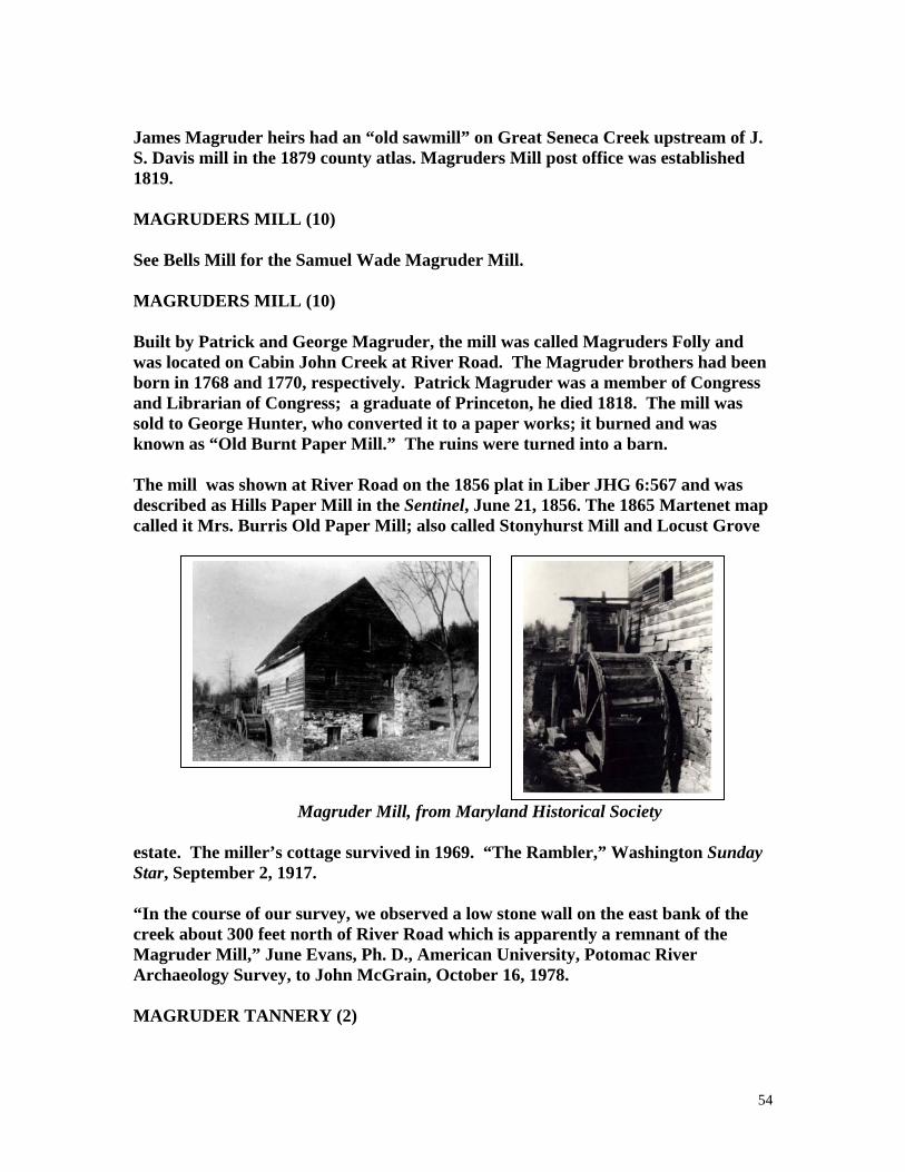
54
James Magruder heirs had an “old sawmill” on Great Seneca Creek upstream of J. S. Davis mill in the 1879 county atlas. Magruders Mill post office was established 1819. MAGRUDERS MILL (10) See Bells Mill for the Samuel Wade Magruder Mill. MAGRUDERS MILL (10) Built by Patrick and George Magruder, the mill was called Magruders Folly and was located on Cabin John Creek at River Road. The Magruder brothers had been born in 1768 and 1770, respectively. Patrick Magruder was a member of Congress and Librarian of Congress; a graduate of Princeton, he died 1818. The mill was sold to George Hunter, who converted it to a paper works; it burned and was known as “Old Burnt Paper Mill.” The ruins were turned into a barn. The mill was shown at River Road on the 1856 plat in Liber JHG 6:567 and was described as Hills Paper Mill in the Sentinel, June 21, 1856. The 1865 Martenet map called it Mrs. Burris Old Paper Mill; also called Stonyhurst Mill and Locust Grove Magruder Mill, from Maryland Historical Society estate. The miller’s cottage survived in 1969. “The Rambler,” Washington Sunday Star, September 2, 1917. “In the course of our survey, we observed a low stone wall on the east bank of the creek about 300 feet north of River Road which is apparently a remnant of the Magruder Mill,” June Evans, Ph. D., American University, Potomac River Archaeology Survey, to John McGrain, October 16, 1978. MAGRUDER TANNERY (2)

55
The 1850 census of manufacturers listed Rufus K. Magruder’s horse and hand-powered tannery worth $4000 with 4 employees and output of 2100 sides annually ($5700) plus hair and bones. MANAKEE AND WATERS (5) See Burnt Mills. MANSFIELD MILL (5) See Black Rock Mill. MARTIN MILL (5) The 1850 census of manufactures listed Anthony S. Martin with a water mill with 2 employees and 2 run of stones; output was 5500 bu meal and 50,000 ft lumber ($3500). MARYLAND GOLD MINE ( ) The Pictorial History of Montgomery County, p. 141, contains a photo supplied by the USGS showing a mill near Great Falls, 1900-1940; there was a stamp mill and a ball mill; includes other photographs. See also Montgomery Mines. MATHIS SAWMILL ( ) Charles Mathis, age 63, was operating a 5-man sawmill with a 58-inch circular blade at Muncaster Mill Road, Washington Sunday Star, August 23, 1970. MERSCHBERGERS OLD MILL (1) This mill is on the Patuxent was mentioned in the district boundaries of 1821, HWM, p. 717. Cf., Howard County list. METZGER MILL 93) The 1879 atlas showed the William Metzger mill on Broad Run near the Potomac. MIDDLEBROOK MILLS (9) Abraham Faw acquired some of William Benson’s property before 1790 and built a mill which appeared on the south side of great Seneca Creek on the Rockville-Frederick Road n Dennis Griffith’s 1794-1795 map. Faw advertised the Middlebrook Mill in Md. Journal, Baltimore, May 12, 1794, and February 15, 1795, a newly built merchant and saw mill “on the most powerful and constant stream in the county” with 4 pair of stones, 4.5 feet in diameter, three French burrs, and

56
plenty of water in dry season; also 240 acres, plus tavern, store, and smithy. In October 1797, General Maccubin Lingan of Georgetown bought the mills and the tract Resurvey on Mill Tract for £ 4500, Liber G:631. Middlebrook Mills post office was established 1809 with Henry Bell as postmaster; succeeded by James Lingan, 1811; Thomas Sanders, 1812; Edward Trail, 1815. The property of the late General Lingan was advertised in the Federal Gazette, January 1, 1814. Heil Peck of Anne Arundel County bought the mill but advertised it in the Federal Gazette, November 1, 1814, and Francis C. Clopper bought it, Liber R:225. Middlebrook Mills was mentioned in the 1821 boundary description, HWM, p. 717. In 1829, Clopper’s brother-in-law, Patrick J. Byrne, was appointed postmaster, succeeded by Thomas Lingan Maccubbbin, a Mr. Trail, Chester Bailey, Elizabeth Stewart, Thomas Patterson, and William Ruxton (1834). The Millbrook Mills post office was discontinued, Baltimore Republican & Argus, April 28, 1846. The mill was not shown on Martenet’s 1865 county map. In 1880, Leonard Buxton was listed as miller at Middlebrook in HMC. Resurvey on Mill Tract had been involved in two disputes, Abraham Faw-vs.-Heirs of Ladowick Yost (1794) and Bank of Columbia-vs.-Heirs of James Lingan (1813). The Baltimore Sun, November 6, 1908, reported the removal of the body of General James McCubbin Lingan from Foxall and New Cut Road, Georgetowm, to Arlington National Cemetery. MILFORD MILL (3) The 1850 census of manufactures listed Samuel Milford with a grist and saw mil with $2000 capital investment, 1 employee, water-powered production, 1 run of stones, and annual output of 2000 bu meal ($1200). Thomas Milford was listed as an atlas patron in 1879, although the name was marked as Midford on the accompanying map. The mill was on Dry Seneca Creek near Poolesville. The relocation of Gamble’s Mill Road past Thomas Milford’s mill was authorized in 1875, MCLR Liber EPB 14:5, “ . . . opening a road at a point on the Poolesville and Beallsville Road . . . To the mill of Thomas Milford and on to Old Bethel Road . . . There is a Public Mill on the rout as petitioned which is accessible only by private roads.” Also listed in Boyd’s directory of 1875 and in HMC. The road is now Md. 109. The 1880 census of manufactures doubled the 1850 valuation of the mill but showed same value of output. Daily maximum was 75 bu; there were 2 run of stones, and 12.5% custom business. A 17-foot fall drove a 10 hp, 4.5 foot broad overshot wheel at 50 rpm. Output was 3300 bbl flour per annum plus feed and meal. Lotus Weiss

57
reported in 1975 that this was originally a Poole Mill and that a wheel pit and race survived. MILL BRANCH (9) Mill Branch was on the Martenet 1856 county map name for Mill Creek listed below. MILL CREEK (9) Mill Creek begins at Washington Grove and flows east and then south to Rock Creek. (THE) MILL DAM ( ) Peter Kemp patented 6 acres called The Mill Dam in 1845, Liber IB No. D:11, MSA. The land adjoined the tract “James and Mary.” MILL LAND (4) Mill Land, 214 acres on the east side of Rock Creek and the north side of the road from Rockville to Baltimore was surveyed for Edward Dawson, March 10, 1724; in 1880, the tract embraced the farm of Judge Richard Judge Richard I. Bowie, HMC, p. 41. Also, HWM, p. 650. The patent was issued in the name of Edward Dawson, although the certificate of survey was in his name, plus that of Edward Dawson, Jr.; Liber IL No. B:5, MSA. In 1817, Mill Land, 216 acres, was conveyed by Edwatd O. Williams, Trustee, to Thomas O. Williams, Chancery Records, Liber B130:108, MSA. MILL POND ( ) James Magruder patented the Mill Pond in 1810, 2.6 acres, Liber JK No. U:304, MSA. The tract began at the first line of Dublin, adjoining Resurvey on Benjamin’s Square. MILL RACE ( ) In 1804, a tract of 171 acres called Mill Race was surveyed for Daniel Gaither, Unpatented Certificate No. 171, MSA. MILL ROAD ( ) See Isaac Ettinge’s mill for the tract called Mill Road.

58
MILL ROAD (6) Mill Road was an alternate name for Long Draught Road, the “road to Hutton’s Mill,” Plat Book 1:3 (1898). See Clopper Woolen Factory. MILL RUN ROAD (4, 9) This road is south of and parallel to Muncaster Mill Road, running west from Muncaster Road along Mill Creek. MILL SEAT (2) Jams White patented Mill Seat in 1760, some 681 acres, also embracing parts of Frederick County, Liber BC & GS No. 21:475, MSA. White also patented 151 acres under the same name in 1772, Liber BC & GS 4:88, MSA. Tract names in the White certificates prove that these sites were identical to Peters Mill, q. v. THE MILL SEAT ( ) In 1797, Elizabeth Ellicott patented a 161-acre tract, The Mill Seat, Liber IC No. C:223, MSA. It was a re-survey of Winchester and Brooke Grove, granted in 1703 to Richard Brooke and in 1726 to James Brooke. MILL SEAT (2) In 1793, Robert Peter had a survey made of Mill Seat, 60-7/8 acres, Unpatented Certificate No. 172. This is the same site as James White’s “Mill Seat” listed above, a site that became the location of Pyles Mill. MILL TRACT ( ) In 1705, Robert Lamar patented Mill Tract, 93 acres, Liber LG 3:555, MSA. Lamar patented Resurvey on Mill Tract, 173 acres, in 1753. Mill tract was on Whetstone Branch, possibly the later site of Watkins Mill. MILLARD MILL (11) The 1880 census of manufactures listed A. Millard with a $2500 capital investment in a custom mill with 2 run of stones and 40 bu/diem maximum capacity. A 12-foot fall on Little Monocacy drove an 11 hp turbine 1.3 ft broad. Output was 40 bbl flour, 27 tons meal, and 1.7 ton feed ($981). A. B. Millard was listed as miller at Dickerson in the 1882 State business directory. (THE) MILLS USE ( )
59
Samuel Magruder, 3d, patented The Mills Use, 25 acres, Liber EI No. 5:381, MSA. This survey made in 1738 began near “the Branch of Captn. Johns” adjoining “Industry.” MILLER SAWMILL (5) Lewis Miller was listed as sawmill operator at Burnt Mills in the 1887 State business directory. Lewis Miller’s flour mill at Burnt Mills “was washed away by the flood”--following the Johnstown flood rains--per American Miller, 17 (July 1, 1889): 489. MILTONS MILL (8) See Muncaster Mill. MONOCACY SETTLEMENT MILL (11) An historic house and mill or still house of Dr. Charles E. Byrd was shown as surviving on the 1969 Md.-National Capital Historic Sites Map. The buildings dated to the late 1700s but did not appear on Martenet’s 1865 county map. MONTGOMERY MFG. CO. (8) See Triadelphia. MONTGOMERY MINES (4) The 1850 census of manufactures listed Osborn & Co., a gold mining firm, with $500 capital investment, 7 employees, and annual output of 84 ounces of gold ($1596) from ore and 10 lb of mercury. Mr. Harrison, the supt., of Montgomery Mines, 1 miles from Rockville, reported that a new electrical reduction process yielded 3.4 ounces of gold from an 110-pound sample, and ore and old mine trailings were yielding $190/ton, Sentinel, July 9, 1880. The Baltimore American of March 4, 1881, reported, “About 1,500 tons of ore are awaiting the resumption of work at the Montgomery county gold mine. The crushing mill is being thoroughly put in order and the pipes that were frozen up have been replaced with new.” MONTGOMERY SILK CO. ( ) Laws of Md., Acts of 1838, Chapter 347, authorized the following to open books for a silk growing and manufacturing company: Thomas P. Stabler, Thomas McCormick, Lloyd Dorsey, Samuel Blunt, Greenberry Griffith, William T. Glaze, Thomas T. Wheeler, Thomas Poole, William Brewer, Adam Robb, Zachariah F. Johnson, William Tomlinson, Francis Valdemar, Samuel D. Waters, and Thomas Gttings.

60
MORTONS MILL (11) The 1783 tax ledger of Linganore and Sugarland Hundreds showed Thomas Morton with part of Beall’s Goodwill with a good gristmill on a fine stream of water. Thomas Morton’s Mill Dam was mentioned in the will of Joseph Harriss, Montgomery Wills, Liber L:372; it was in the Barnesville area; May 19, 1797; also mentioned in a roads proposal, Md. Gazette, October 29, 1789. In 1792, citizens petitioned the General Assembly for a road from the Frederick County line to the mills of Thomas Morton and Zachariah Maccubbin, then to the main road to Georgetown. The Assembly passed the bill in Chapter 26. See, Pat Melville, “Roads in Montgomery County, 1777-1794,” The Archivists’ Bulldog, 15 (September 14, 2004): last page. Ignatius Davs offered to sell part of a mill held in common with Thomas Morton on the new-cut road from the mouth of the Monocacy to Baltimore and near the river mouth, Frederick-Town Herald, August 7, 1802, p. 2. Joshua Johnson advertised a mill, formerly Morton’s, with a 17-foot fall on Little Monocacy, 34 miles from Georgetown, 47 miles from Baltimore, Frederick-Town Herald, May 26, 1810. MOUNT CARMEL MILL (3) See Gott Mill. MULINIX MILL (12) MULINIX MILL ROAD This was the successor of Pigman and Crowe Mill and was on the Patuxent at the present Mulinix Mill Road, which runs NE from Md. 108 near Damascus. John J. Mullinix grist and saw mill was mentioned in Laws of Md., Acts of 1884, Chapter 125. The name was spelled Mullineaux in the 1879 county atlas. The American Miller, 12 (July 1, 1884): 371, reported, “John J. Mullinix, Florence, Md., has placed his order with S. Morgan Smith, York, Pa., for a Success Water Wheel, and all the machinery required for a first-class custom grist mill.” Only a closed-up general store survived at the Mulinix place name in 1967. There was a pond nearby. MULLINEAUX MILL (12) Same as Mulinix Mill. MULLICAN MILL (4)

61
S. T. Mullican was listed as miller at Rockville in 1887 State business directory. MULLINEAUX MILL (12) See Mullinix Mill. MUNCASTERS MILL (8) MUNCASTER MILL ROAD The second mill on the North Branch of Rock Run and on the road from Norbeck to Redland, it was built about 1820, supposedly by Joseph Elgar, for one of the Robinsons or Muncasters. The mill had a large overshot wheel of 15-foot diameter with a 6-foot wide face; three run of stones for flour and a meal sifter for corn. Also a separate sawmill with an oscillating saw, and alter a circular saw, HMCM, p. 74. The mill was owned in1878 by William Edward Muncaster, HWM, p. 768. George E. White was miller 1892-1920. The Redland Hunt met here on present Md. 115, a road that runs from Montgomery County Airport to Norbeck Road [1976]. The mill closed in 1925 and many heavy timbers were used to build a stable. Muncaster Mill in 1934-35 by HABS team, from Library of Congress. The WPA came here to check details for the first restoration of Pierces Mill in Rock Creek Park. Numerous photographs by the WPA and HABS staff are in the Library of Congress. The mill burned in 1935 per Mayflower Log, July-August 1935, p. 8. In 1969, Dick Abel, a local high school teacher, conducted a dig at the mill site that is described in “The Muncaster Mill Seat” by Charlotte Beckett, Lisa Naher, and Janet Pussey, reprinted by the Montgomery County Historical Socieety, 1969. (See Oakwood Mills for O. Z. Muncaster’s steam mill.)

62
The mill is commemorated by an historical marker on Muncaster Mill Road, Rockville. [A still functioning Muncaster Mill in England was shown on a PBS broadcast, June 6, 1997, “British Rail Journies” showing excursions in the Lake District. The UK mill was shown in the 1910 Baedecker’s Great Britain, p. 94, near Muncaster Hill. The Pennington family owned that Muncaster Mill; it was visited by John Ruskin and Edward VII, a stone mill with a steel water wheel on the River Milte] MUSGROVE MILL ( ) John Musgrove owned one old gristmill on the tract Treed Land per the 1783 tax list of Upper Newfoundland and Seneca Hundreds. NEWLIN MILL (8) This grist, saw, clover-seed, and flaxseed mill was built by Davis Newlin, a Quaker, on Hawlings River; before that, he had a fulling mill dated at about 1800, HWM, p. 781. The site was near Triadelphia per HMC, p. 93, and the mill stood on the Oakley estate, 1.5 miles south of the road from Brookeville to Laytonsville. A deed of 1816 provided that David Newlin should have liberty of continuing the mill dam, HMCM, p. 239. A road at Newland [sic] Mill (t Brookevile) was mentioned in the Sentinel, September 14, 1854. The 1850 census of manufactures showed Artemas Newlin with $1000 capital investment in a water-powered grist, saw, and clover mill, listing 1 employee and annual output of 1100 bu meal and 15,000 ft lumber ($775), plus 200 bu clover seed ($1000). The 1865 Martenet county map showed A. Newlin’s mill at Brookeville on Reedy Branch. See also Brookville Wool Manufactory. NEWLIN WOOLEN MANUFACTORY (8) See Brookeville Woolen Manufactory. NEWPORT MILLS (7) NEWPORT MILL ROAD See Duvall Mill. NORRIS MILL ( ) A road was authorized between Frederick and Montgomery Counties to start on the Damascus-Georgetown Road and intersect the road to William Norris Mill, Md. Journal, Rockville, July 11, 1846. NORTHWEST MILLS (5)

63
Same as Zeigler Mill. O’NEILL AND DEAKINS MILL (6) See Deakins Mill. OAKLAND GRIST AND SAWMILL (1) Same as Darby Mill (near Laytonsville). OAKLAND MILLS (11) See Hempstones Old Brick Mill. OAKWOOD MILLS (9) O. Z. Munaster advertised that his steam mill was repaired, Sentinel, January 19, 1866. He offered a steam saw and grist mill for sale, Ibid., February 21, 1873. It was on the Point of Rocks Railroad, “2 miles this side of Gaithersburg” and 18 miles from Washington and a half-mile from a Junction Station; 540 acres, 400 in woods. See also, Dona L. Cutler, The History of Dickerson, Mouth of Monocacy, Oakland Mills and Sugarloaf Mountain (Heritage Books: Bowie, Md., 1999). OFFUTT MILL (6) For the U. D. Offutt who was listed as a miller at Darnestown in 1880, see Black Rock Mill. OFFUTT MILL ( ) A James Offutt mill was mentioned in a roads document of 1777/78 as lying on Captain Johns Creek. OLD MILL (5) The “Old Mill” shown in the atlas on Paint Branch is probably Harper Woolen Mill, q.v. OLD MILL (13) The 1879 atlas showed an “old mill” near the house of Alfred Ray between Rock Creek and the B. & O. Railroad near Forest Glen, then in Election District No. 7. OLD MILL TRACT (18)

64
Old Mill Tract was the property of Mahlon Janney Chandlee, OBGF, pp. 279, 305. See Chandlee Mill. OLD MILL PLACE (5) See Holmes Mill. OLD PAPER MILL (10) See Magruders Mill for the “old paper mill” shown in the 1879 atlas on Cabin John Creek, ORENDORF MILL ROAD (7) See Bells Mill in Election District 10. OWEN BONE MILL (1) The 1850 census of manufactures listed Edward W. Owen with $224 capital investment in a water-powered bone mill with 1 employee and annual output of 1400 bu bone dust ($840). OWEN SAWMILL ( ) Edward Owen was listed with an old sawmill on Mount Arratt in the 1783 tax list of Lower Newfoundland, Rock Creek, and Seneca Hundreds. Owen’s father Robert Owen had left him part of Contentment, on the SW side of Rock Creek “beginning at the old dam.,” 1779, HMCM, p. 208. PARSLEY MILL (8) The 1880 census of manufactures listed R. T. Parsley mill, with 90% custom trade, $200 capital investment, 1 run of stones, and 20 bu/diem maximum capacity. A 22-foot fall on Hawlings River drove 2 overshot wheels 4 ft 4 inches broad at 20 rpm, developing 14 hp. Annual output was 135 tons meal and 5 tons feed ($3000). PATUXENT MLL ( ) Albert Gallatin’s survey of manufactures of 1810 listed a mill only described as “Patuxent” which had 300 spindles. The most likely match is Triadelphia, q. v. PERCY MILL (4) This mill on Watts Creek was owned by Strove and Percy, then by Braddocck, HWM, p. 740. It was the property of Mr. Stonestreet in 1882.

65
PETERS MILL (10) W. T. Peters was listed in the 1887 State business directory as miller and dealer in general merchandise at Glen. The mill was reported as having been swept away in the rains following the Johnstown flood, Baltimore American, June 3, 1889, p. 3. PHILLIPS MILL ( ) Phillips Mill was mentioned as near Clarksburg in Frederick-Town Herald, November 2, 1811. PIGMAN MILL (1) See Crowes Mill at Goshen. PIGMANS MILL (12) Shown on Dennis Griffith’s 1794-1795 map on Patuxent Rive, 8.5 miles below Parrs Springg. The mill was on a tract called Hillsborough, patented in 1795. Ignatius and Joseph Pigman consolidated some properties on Seneca Creek, which they called Land of Goshen; those lands, including Goshen Mill, were sold to Edward Crowe, for which, see Crowes Mill in Election District 6. The Rev. Ignatius Pigman sold the land, and the family moved west about 1810. Pigman, the miller, was a sponsor of Oliver Evans’ book, The Young Millwright’s Guide. The Patuxent site was mentioned in MHM, 28:269 and in HWM, p. 656; it later served as the site of Mulinix Mill. Pigman had another tract, Pigman’s Inheritance, on the Hawlings River, and Mrs. Pollard Kelleher of Rockville visited the site in March 1971 and was told by the owner that there were two mill races visible along the river. PILLING MILL(5) Same as Duvall Mill. PLUMBER MILL (3) The 1850 census of manufactures listed P. and G. Plumber Water mill with $2500 capital investment, 2 employees, 3 run of stones, and 1 saw. PLYERS MILL (13) PLYERS MILL ROAD Plyers Mill Road runs between Georgia Avenue Connecticut Avenue south of Wheaton; mill is extinct.

66
POWDER MILL ( ) Geographical Description of Md. And Del., p. 143, listed one powder mill in the county in 1807. We can only account for powder mills in Prince Georges County. POOLE MILL (3) Poole Mill became Milford Mill per Lotus Weiss’s 1975 research. PRATHER MILL 4) See Horner Mill. PRICE WOOLEN MILL (3) The 1880 census listed Samuel Price Woolen Manufactory with $2000 capital investment, 3 male and 2 female employees; water-powered production; 4 cards, 2 looms, 2 fulling stocks. Annual output was 5500 rolls ($2200), cloths, cassinets, linsey, flannels, blankets ($1000), and 2200 yd of cloth fulled and dressed ($350). PYLES MILL (2) The mill traces back to 1799 or before. In that year, on February 12, a new mill on Ten Mile Creek was advertised, the mill structure being 55 by 32 feet, two stories, lower of stone, upper of frame. The mill had a pair of burrs and a pair of country stones, two overshot wheels with a 23-foot fall and an adjoining sawmill powered by a flutter wheel. The Seneca Trails web site reports that Ignatius Davis sold the mill to Levy Phillips on May 12, 1810. In 1818, Phillips sold to Isaac Breathead for $5000. Then in 1827, George Peter sold “Mill Seat” to William Sellman according to research by Sugarloaf Regional Trails. Horatio Trundle acquired the works, and in 1860 sold to William F. Pyles and John Carlin. Plummer Pyles’ grist and saw mill was shown in the 1879 atlas on Ten Mile Creek west of Clarksburg where the Martenet 1865 county map had shown W. F. Piles [sic]. George Robertson became owner in 1868 and Isaac Davis in 1874. The 1880 census of manufactures listed Plummer Davis custom mill on Tenmile Creek with $1500 investment, 1 employee, 2 run of stones, 50 bu/diem maximum. A 24-foot fall drove a 12 hp overshot wheel 4 ft broad at 6 rpm. Output was 60 bbl flour, 10 bbl rye, 24.1 tons meal, 3.2 tons feed, and 1000 lb buckwheat ($968). Daivis Mill was listed at Boyds in 1880 by HMC, p. 121. Sugarloaf Regional Trails performed additional research on this mill in 1977. There was a report that the mill stood on Tax Map Parcel 60 and was recorded in MCLM

67
Deeds 4490:805. Mrs. Alice Hawes called it as a stone mill at the bottom of a hill, many years before. Mr. Charles Linthicum recalled a Startlemeyer [?] Mill. The mill race was still visible. The mill dwelling burned approximately 1970. The Sugarloaf data reported that the mill site was a private yard with no evidence of a mill. The race was a miniature C. & O. Canal. The race was well defined, north of the B. & O. Railroad, east of Bucklodge Branch on the property of Mr. and Mrs. Howard Hough. The on-line data from Seneca Trails available in 2006 confirms the disappearance of the mill and gives the location as a tributary of Ten Mile Creek, a branch of Little Seneca Creek, where Old Baltimore Road crosses the tributary. The mill site and tail race were on the south side of Old Baltimore Road and west of the tributary. A new pond has been developed on the stream on the south side of West Old Baltimore Road. PURDAM MILL (12) John L. Purdam saw and grist mill was shown on Martenet’s 1865 county map on Little Bennett Creek. QUARY MILL (16) QUARY MILL ROAD The mill was probably near the burial site of John Nicholas Quary, which is on Haywire Farm near the present Query [sic] Mill Road and Ebsworthy Road, Nicholas Quary purchased 96.5 acres called Maidens Power from Samuel Boone, plus part of Montrose and part of Resurvey on Rich Meadow, 127 acres, for £ 4000 on May 8, 1779. In his will, he left his wife a dower of land and “the profit of the grist and saw mills.” The rest of the land was divided equally between his two sons, Daniel and Henry. The present Query Mill Road runs west off Turkey Foot Road to Glen Road. No mill survived in 1976. RAWLINGS MILL (8) James Rawlings mill was shown south of Snells Bridge on a branch 0.25 mile from the Patuxent on the 1865 Martenet county map. It was later shown in the 1879 atlas as Samuel Hopkins Mill. The mill was on the present Tucker Lane; a foundation survived in 1984 on the land grant called Bear Garden, see Jacqueline R. Jackson, “It’s Such a Treasure . . . And Such a Find,” Sunday Sun, Match 11, 1984, p. T-1. Eleanor M. V. Cook equated the following mills on the Patuxent and the tract Bear Garden: Richard Thomas, William Thomas, Joseph Bond, William Adams Preston N. Schooley, James Rawlings, Benjamin A. Rawlings, Matilda R. Rawlings, and Samuel Hopkins, “Early Water Mills in Montgomery County,” The Montgomery County Story, 3 (November 1990): 139.

68
RAY MILL (13) A small family mill of Alfred Ray was on a stream now in Kensington Parkway south of Saul Road and the Junior High School. RESURVEY ON MILL TRACT (9) This was a 6-acre tract on Seneca Creek acquired in 1807 by James M. Lingan from Archibald Trail, Liber N:275. Trail had acquired it from Abraham Faw in 1797, Liber G:631. Faw had acquired 13 acres from Ladowick Yost; see Faw-vs.-Yost, Chancery Papers No. 1788 in the year 1794, MSA. This land became the site of Middlebrook Mills. RICH AND WATERS MILL ( ) Isaac M. Rich and Franklin Waters announced dissolution of their milling business, Sentinel, February 19, 1858. Cf., Black Rock mill. RICHARDSONS MILL () A roads document of 1777 mentioned, “. . . . and from Richardsons Mill to the Main Road that leads by Andrew Houghs.” It was mentioned as the terminus of a road from Bladensburg in 1807, HWM, p. 656. RIGGLES SAWMILL (5) The 1880 census of manufactures listed F. L. Riggle with a 20 hp stream sawmill worth $1500 with 4 employees, 2 circular saws, and 100,000 ft of annual output ($2100). The 1880 State business directory listed F. L. Reigle [sic] at Spencerville. RIGGS MILL (1) See Crows Mill. REINHART MILL (11) H. Reinhart was listed as miller at Dickerson in the 1880 State business directory. RIVERTON MILL (8) See Chandlee Mill. ROBERTSON MILL (4)

69
The gristmill on Watts Branch formerly owned by the later John T. Robertson was advertised for rent by Mrs. Harriett Robertson, and simultaneously for sale by its mortgage holder in different ads in the Sentinel, June 21, 1881. It was one mile from Rockville and appeared in the 1879 atlas although the name was given as John Robinson (Ref. to mortgage recorded in EPB 16:353). ROBERTSONS MILL (8) George Robertson was listed in 1783 tax list of Lower Newfoundland, Rock Creek, and NW Hundreds with Batchelors Forest and a gristmill of 2 pair of stones, bolting gears, stone mill house, and sawmill. The original bounds of District 5 in 1799 placed Robertsons Mill at Rock Creek and “Bladensburg Road,” apparently at the site used by Muncasters mill, HWM, p. 757. ROBINSON GRIST MILL (4) Spelling error for Robertson, q.v. ROBINSON MILL ( ) Niles Register, Supplement to Volume 3, February 1813, reported on the patent infringement trial in Baltimore that started December 5, 1812. One statement about persons being sued by Oliver Evans mentioend Samuel Robinson: “The defendant’s mill is situated in Montgomery County, does not work all the year, grinds twelve barrels per day, and has the machinery to one pair of stone only.” [Unclear which site this matches with.] ROCK CREEK MILLS (4) Veirs Mill (q. v.) was called both Rock Creek Mill and Rockville Flouring Mills. ROCKVILLE FLOURING MILLS (4) See Viers Mill. ROUTZAHN MILL (8) M. C. Routzahn was listed as miller at Olney in 1880, HMC. P. 137. ROZZELL MILL (11) James Rossell was listed as miller at Dickerson in 1880, HMC, p. 127. RUSH MILL (8) See Lansdale Mill at Sandy Spring.

70
RUXTON MILL ( ) A mounted black and white photograph in the MHS graphics collection shows a clapboard mill with a steel Fitz overshot water wheel. Filed as Ruxton Mil on Olney-Colesville Road, donated by a Mr. Gamble. SANDY HOOK MILL ( ) A woodcut in the Sentinel, August 25, 1960, showed a frame mill with a water wheel two stories high, the Sandy Hook Mill. SANDY SPRING MILL (8) See Lansdale Mill (Rush Roberts) at Sandy Spring. SAUNDERS MILL (4) N. W. Saunders was listed as owner of an iron and saw mill at Potomac village in the 1887 State business directory. SAW MILL CREEK (6) Saw Mill Creek was shown on the 1775 “Map of the Most Inhabited Parts of Virgnia Containing the Whole Province of Maryland” drawn by Joshua Fry and Peter Jefferson. It was the first creek east of Seneca Falls (Sinegar) and was upstream of the Great Falls. Cf., Bealls Old Mill. SAW MILL LOT ( ) Saw Mill Lot, 8 acres, was seized from John Moore at the suit of David Arnold, Md. Journal, Rockville, May 28, 1845. SCHAEFFER MILL (6) SCHAEFFER MILL ROAD The mill road runs west off Md. 119 NE of Dawsonville on the 190 survey map and crosses Seneca Creek to reach Md. 121. No mill survived in 1976. It was probably downstream of Hoyles. Not shown on Martenet’s 1865 county map. SCHOOLEY TANNERY (5) The 1850 census listed the Presley N. Schooley tannery with $1000 capital investment, 3 employees, and 40 vats. Annual output was 880 sides of leather and 200 calf skins ($2753).

71
SCHWARTZ’S MILL ( ) Schwartz’s Mill was built in 1887 on Chieftan Avenue across from the B. & O. Station at Derwood; it was 32 x 56 feet, Montgomery Sentinel, April 15, 1887. It burned along with the train station [the depot deisged by Baldwin and Pennington] on January 17, 1954 (Data from “Derwood” on the internet, discovered October 8, 1999.) SEARCH MILL ( ) G. M. Search advertised a steam gristmill at Spencerville, Montgomery County, on the road from Laurel to Sandy Springs. Thee were three run of stones. The mill was new and in complete order for the manufacture of flour and chop, “no other mills within four miles,” Baltimore Sun, May 13, 1870. The 1879 G. M. Hopkins county atlas plate of Election District No. 5 showed the Griffith Search house on the south side of the present Md. 198 between Spencerville and Burtonsville (called Laurel Road) in 1879. G. M. Search was listed as miller at Spencerville in the 1880 State business directory. SENECA CREEK MILL (6) The Seneca Creek grain mill is said to have been built at present River Road about 1780. Wiliam Deakins, Jun., and Bernard O’Neill advertised a grist mill at the mouth of Seneca Creek, Md. Journal, Baltimore, October 8, 1785. A Deakins Mill had been mentioned in a road authorization of 1777/78. In 1825, Washington Bowie owned “part of Seneca Ford and Mill thereon” plus 280 acres of “Middle Plantation,” the tract “Thomas Discovery,” and some islands in the Potomac. However, Bowie, a wealthy merchant of Georgetown, D. C., never lived there. He had been born at the Bowie homestead north of the present Wheaton on August 12, 1776, and George Washington was his god-father. Before the War of 1812, he had made a large fortune in shipping and owned the Bowie -Sevier House and a summer home at Olney. His business suffered on account of the war. The Baltimore American carried an advertisement to sell the mill on December 21, 1844: VALUABLE MILL PROERTY, SENECA MILLS, situated on Seneca Creek, an unfailing stream within a half mile of the Chesapeake and Ohio Canal, with which it connects and within 24 miles of Georgetown is for rent or sale as above. The mills are capable of making 150 barrels of flour per day. Attached to them is a new and excellent Saw and Grist Mill . . . Apply to Geo. W. Taylor, on the premises.

72
--National Park Service --National Park Service The mill was on the north side of River Road and was later moved to the other side. In 1855, the mill, then in the hands of Francis Dodge, Robert Dodge, and Allen Dodge, trustees of Mrs. Benjamin P. Poore, was sold to John Darby and his son Upton Darby. Mrs. Poore had inherited the mill from her father, Francis Dodge. Traditional stories hold that the mill burned twice during the Civil War period, dates of which are lacking. Doris Cobb’s 1968 paper showed Upton Darby roofing the mill in July 1863, using material from the DeFeif Mill. Mrs. Cobb found a day book entry made in November 1866, “Agreed with H. Hays for the rebuilding of Seneca Mills .. . .” The 1865 Martenet county map showed Upton Darby’s house on the north side of River Road and J. W. Darby’s Seneca Grist and Saw Mill on the south side. Although it was reported that Upton Darby turned the business over to his son Ernest Hicks Darby in 1872, Upton Darby appeared as an atlas patron and the firm of Upton Darby and Son was listed in the 1887 State business directory, placed on River Road. The 1880 census of manufactures showed the mill with $10,000 capital investment in it, 4 run of stones, and 200 bu/diem maximum capacity, with 10% of its business being custom-and of course 90% being merchant business, in other words a big, well capitalized operation. A 13-foot fall on Seneca Creek ran 2 overshot wheels 16 ft broad at 10 rpm to develop 40 hp. Annual output was 3100 bbl flour, 67.5 tons meal, and 103.5 tons feed ($21,310).

73
The American Miller of July 1, 1888 (16:497) reported, “Messrs. Upton Darby & Son are having a general overhauling of their roller mill at this place, putting in new cleaners, new cloth, a lot of belting, etc. The overhauling is being done by Willie Holly, and F. W. Kepner, two of Maryland’s best millwrights--B. F. Coames, Seneca, Md.” The same trade journal reported on November 1, 1888 (16:786), “Aug. Wolf & Co., Chambersburg, Pa., have shipped Upton Darby & Son, Seneca, Md., three McAnulty Force Feeders, and other machinery.” The American Miller of August 1, 1899 (27:643) reported, “Upton Darby & Son have placed new rolls and wheat cleaning machinery in their flour mill at Seneca, Md.” The next year, the Sun of June 30, 1900, reported the sale of a milling property of Upton Darby & Son of Seneca to Mr. Crenshaw of Baltimore for $4450. The Sun mentioned a “recent failure of the firm”. The works also sold milling supplies, and Darby owned his own canal boat for shipments to Geogetown; there was a warehouse halfway down Seneca Creek with a railway between. The small boats carried grain down river to the guard lock between Riley’s Lock and Violet’s [or Violette’s] Lock; cargo was transferred to canal boats for the rest of the trip. In 1902, E. Darby sold the mill to Wilson B. Tschiffeley, who operated until his death in 1914. His son, Thomas Tschiffely took over but died in 1918, and his brother Worthington Tschiffley soon ceased operations. The Seneca Trail web site gives 1931 as the date the mill closed. The mill was still standing in1957, a four-story wood frame flourmill, abandoned for 25 years. The mill was obliterated in building a new bridge to carry River Road over the creek. The frame miller’s dwelling survived at River Road, No. 94 on the Md.-National Capital Historic Sites Map of 1969. Seneca Mills was established as a post office in 1819, changed to Rushville in 1832, changed to Dawsonville in 1854. Tschiffley Mil Road (on some signs spelled “Tschiffley“) was shown on Map 7 in Collection of Maps of C. & O. Canal, running along the west bank of Seneca Creek near Lock 24. The race below the mill site is practically a canal and serves as a mooring place for power boats and row boats for a series of summer cottages built along the banks. Pronunciations of both “Shi-FILLY” and “Shif-fay-lee” are offered for the name of the last mill operators. See, “A History of Dawsonvile and Seneca,” Jane Chin Sween, Bethesda, Md., 1967 (ms. at Montgomery County Historical Society) and also “Seneca,” by Jane Chin Sween, The Montgomery County Story, November 1971, p. 4f. The Seneca Trail web site available in 2006 reported that no remains of the building, mill ruins, or dam existed but there were apparently two races at Seneca Creek and River Road. The mill site was paved over to improve River Road. One race could be seen behind the storage building just to the right of Pool’s store. The mill pond was located at the back of the storage building where its overflow dam

74
could be seen. The main dam can be found by parking where Berryville Road runs parallel to the creek (observations by Seneca Trails, 2004). Sugarloaf Regional Trails described the race as 25 feet wide and 6 feet deep in 1977 and placed the mill site 300 feet from the Poole store (16315 River Road) and the Allnut House (built by Upton Darby in 1855). The exact dates of the two fires are lacking, although History of Potomac states that one fire took place during the Civil War; that source also contains a photograph. See also, Kate Mulligan, Towns Along the Towpath (Wakefield Press: Washington, D. C., 1977). Another photograph appears in Thomas F. Hahn, Towpath Guide 1982, 1987, p. 57. (attributed to the National Park Service)—Hahn gave the date of the Tschiffeley Mill fire as 1956. SENECA STONE MILL (6) The large red sandstone ruin on the north side of the canal, west bank of Seneca Creek, was built about 1837, to cut and dress stone shipped in from quarries to the west in mule-drawn gondola cars via a narrow gauge railway. The mill drew water from the canal turning basin to power a turbine, discharging the used water into the creek. --Seneca Trails The Stone Cutting Mill Ruin A skirmish took place between Brewer’s Company of the Prince William Cavalry plus Mosby’s Rangers against the Sixth Michigan Cavalry which was encamped at Seneca Mills, June 11, 1863. “Mosby dashed up the tow path while the Federals fell back and took up a position behind the bridge near the mill and along the creek, which was bordered by the trees and the underbrush.” The skirmish took place in a deep cut in the road and the Federals were routed, Mosby’s Rangers, J. J. Williams (1896), pp. 69-70. Mosby’s forces passed Seneca Mills again on their way to burn

75
the blockhouse at Muddy Creek, July 12, 1864, Ibid., p. 189f. See also Sugarloaf Regional Trails pamphlet of 1976, “Seneca Sandstone Biking trail.” This structure is No. 97 on the Md.-National Capital Historic Sites map of 1969. See, Jane Chin Sween, “Seneca,” The Montgomery County Story, (November 1971). See also, Paul H. Douglas and William K. Jones, “Sandstones, Castles, and the Smithsonian,” The Smithsonian Journal of History (Spring 1968): 58. See also Robert C. Braunberg, “The Seneca Sandstone Quarries,” Echoes of History, Pioneer America Society, April 1975, where there is a mention of the use of the sandstone in the Smithsonian Institution’s “castle” in Washington, D. C. In 2002, students of Mount St. Mary’s College produced a film about quarry days called “From Hell with Love” A photo of the workmen at the stone mill had been preserved by an African American, Tilghman Lee, which was copied by George McDaniel in 1978. This location is about 22 miles on the C. & O. Canal. The Maryland Historical Trust has established a Seneca Historic District, Site No. M-17-63. The stone-cutting mill bears Site No. M 17-53. Measurements of the ruin were 30 by 75 feet with walls about 15 ft high. SHANKLE MILL ( ) See Duvall (Valley Mill). SHAW MILL (8) Nathan Shaw was listed as miller at Redland in 1880, HMC, p. 139. The census of manufactures that year showed Shaw’s sawmill with $225 capital investment, 1 employee, and 1 circular saw. A 15-foot fall on Rock Creek drove a 16 hp overshot wheel 4 ft broad at 24 rpm to cut 50,000 ft lumber and 50,000 laths ($500). The gristmill with $300 capital investment had 1 employee, 3 run of stones, 50 bu/diem maximum capacity, and 75% custom business. The same fall drove a 20 hp overshot wheel 5 ft broad at 2 [?] rpm to grind 103 tons meal, 19 tons feed, and 400 bbl flour. SHAW MILL (8) The 1880 census of manufactures listed C. H. Shaw with a mill of $100 capital investment, doing 87% custom business, 1 run of stones, and 40 bu/diem maximum capacity. A 21-foot fall on Rock Creek drove an overshot wheel 3 ft 6 inches broad at 20 rpm to develop 20 hp. Annual output was 54 tons meal and 2 tons feed. George Shaw was listed as miller at Brighton in the 1887 State business directory.

76
SIMPSONS MILL (9) Same as McCubbin/McKubin or Clopper. SINNINGS MILL (11) The inhabitants of the county intended to petition the General Assembly for a road “from Luckett’s and Davis Ferry, through the neighborhood of Morton’s and Sinning’s Mill,” Md. Gazette, October 29, 1789. SLIGO MILL (13) SLIGO MILL ROAD Sligo Mill was at Tacoma Park, where Sligo Mill Road crossed Sligo Branch. In 1811, Elie Williams, Daniel Carroll of Duddington, and Charles Carroll of Bellevue went into business as Williams and Carrolll to manufacture paper, build mills, distill grain, and raise livestock. They bought 414 acres over 1811-12. The mill was advertised for sale in 1819 along with the distillery equipment. Williams dropped out and Charles King rented the mill in 1824-26. Then S. Tubman; then Faw in 1831; Pierce Pumphrey in 1833; John Davis from 1839 to 1845 or later. Illustration in Tacoma Park, A Photo History of Its People, p. 22. J. L. Bond was listed as miller at Sligo in 1880, HMC. Not shown on the 1865 Martenet county map. CHM 31-32:88-90. The Sligo place name was 0.5 mile north of Silver Spring on U. S. 29 per GZMD, 1941. SMITHS SAWMILL (4) Captain Smith’s steam sawmill was shown down the road from Hodges sawmill near Rich Branch, SW of Rockville and west of present Du Fiefs Mill Road on the 1865 Martenet county map. SNOWDEN MILL (5) In 1723 to Richard Snowden acquired a patent of 546 acres on what came to be the Columbia Road; Paint Branch passed through the tract, Boyd, HMC, p. 38. Snowden had at the greatest extent 10,625 acres. The large Snowdens holdings stretched from Fairland Road south to the East Randolph Road. It was obviously surveyed from vacancies, as it consists of two main blocks linked by a narrow neck or corridor, as plotted by Michael F. Dwyer from a certificate in the MSA (1992). By 1992, an established suburban development was known as Snowdens Mill and had a neighborhood sign on East Randolph Road east of the Paint Branch Park. This mill would have been upstream of the Duvall or Valley Mill.

77
SNYDER MILL (9) The 1850 census of manufactures valued Remus Snyder’s water mill at $3500, listing 2 employees, 2 run of stones. Annual output was 3300 bu meal ($1650). The grist and saw mill of Remus Snyder’s heirs was shown on Great Seneca Creek north of Gaithersburg, east bank of the creek, on the 1865 Martenet county map. Also shown in 1879 atlas. Possibly the same as Middlebrook Mill. SPARROW MILL (4) The 1850 census of manufactures listed Benjamin Sparrow’s mill with $2500 capital investment, 1 employee, 1 pair of stones run by water power, and annual output of 1600 bu meal and 15,500 ft lumber ($1210). SPECK MILL (8) Speck was the last owner of the Allen Bowie Davis Mill, q. v. The mill was torn down to pave the road. The National Capital and Planning Commission owned the site in 1969. STEAM SAW AND GRIST MILL (5) The steam saw and grist mill shown on Martenet’s 1865 county map on the east side of the road from Sandy Spring to Ashton was the same as Farmers. STONE MILL (6) See Seneca Creek Stone Mill. STONE MILL (8) Art Stone, age 87, was still running a sawmill at Sandy Spring, powered by a 1928 steam traction engine. He had set up there in 1964, AARP News Bulletin, June 1985. STONYHURST MILL (10) See Magruders Mill. STORM MILL (10) Philip and John Storm were listed as millers at Offutts Cross Roads in 1880, HMC. STRAUSE MILL (4)

78
The grist and saw mill of the late Henry Strause was advertised by Matthew Murray in the Morning Chronicle and Baltimore Advertiser, March 8, 1821; it was on the road to the mouth of Monocacy, 2 miles from Rockville, a 430-acre property; possibly the Wootens mill of 1865 map. SOUDER MILL (12) George L. Souder was listed as owner of a steam saw and grist mill at Damascus in the 1887 State business directory. STABLER MILL (8) George L. Stabler was listed as miller at Brighton in the 1887 State business directory. SYDDANES, JONES & CO. MILL ( ) Syddanes, Jones & Co., Derwood, Md., will build a $3,500 warehouse in connection with their flouring mill,” American Miller, 16 (July 1, 1888): 502. TABLERS MILL AND TANNERY (2) Abraham Tabler’s mill and tannery were shown on Supers Branch at Hyattstown on the 1865 Martenet county map. For the mill, see Hyattstown Mill. TOWNSHENDS WOOLEN MILL (1) See Brookeville Woolen Mill. THOMAS MILL (8) In 1794, Richard Thomas built a mill at Brookeville and in 1801 a house that was later used as the rectory of the Protestant Episcopal Church when T. J. Scharf wrote in 1882, HWM, p. 781. TRAIL MILL (9) Burton Trail was listed a miller at Gaithersburg in 1880, HMC. The census of manufactures that year listed Trail with $6000 capital investment in a custom mill with 2 employees, 3 run of stones, 40 bu/diem maximum capacity. A 10-foot fall on Seneca Creek ran a 16 hp, Leffel wheel 2 ft 2 inches broad at 180 rpm. Annual output was 480 bbl flour, 10 bbl rye, 116 tons meal, and 23 tons feed ($6193). TRIADELPHIA MILLS (8)
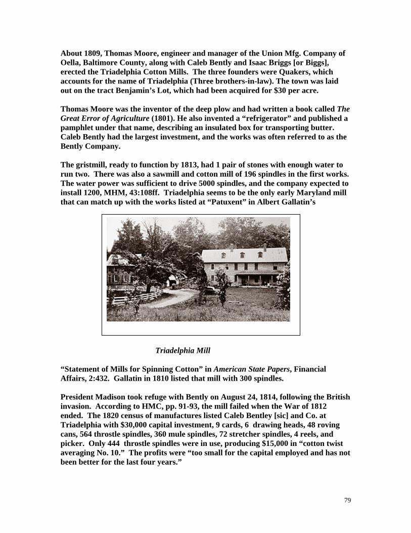
79
About 1809, Thomas Moore, engineer and manager of the Union Mfg. Company of Oella, Baltimore County, along with Caleb Bently and Isaac Briggs [or Biggs], erected the Triadelphia Cotton Mills. The three founders were Quakers, which accounts for the name of Triadelphia (Three brothers-in-law). The town was laid out on the tract Benjamin’s Lot, which had been acquired for $30 per acre. Thomas Moore was the inventor of the deep plow and had written a book called The Great Error of Agriculture (1801). He also invented a “refrigerator” and published a pamphlet under that name, describing an insulated box for transporting butter. Caleb Bently had the largest investment, and the works was often referred to as the Bently Company. The gristmill, ready to function by 1813, had 1 pair of stones with enough water to run two. There was also a sawmill and cotton mill of 196 spindles in the first works. The water power was sufficient to drive 5000 spindles, and the company expected to install 1200, MHM, 43:108ff. Triadelphia seems to be the only early Maryland mill that can match up with the works listed at “Patuxent” in Albert Gallatin’s Triadelphia Mill “Statement of Mills for Spinning Cotton” in American State Papers, Financial Affairs, 2:432. Gallatin in 1810 listed that mill with 300 spindles. President Madison took refuge with Bently on August 24, 1814, following the British invasion. According to HMC, pp. 91-93, the mill failed when the War of 1812 ended. The 1820 census of manufactures listed Caleb Bentley [sic] and Co. at Triadelphia with $30,000 capital investment, 9 cards, 6 drawing heads, 48 roving cans, 564 throstle spindles, 360 mule spindles, 72 stretcher spindles, 4 reels, and picker. Only 444 throstle spindles were in use, producing $15,000 in “cotton twist averaging No. 10.” The profits were “too small for the capital employed and has not been better for the last four years.”

80
Following a decree won by his late partner Thomas Moore, Caleb Bently & Co. advertised Triadelphia Cotton Factory in the National Intelligencer, December 21, 1822. The building was stone, three stories, 25 x 29, with 564 throssel spindles, and a pair of mules, 13 carding machines, several of which were entirely new . . . 10 power looms . . . Set of Wool Carding Machine . . . Merchant mill with two pair of 5 feet stones one of which is known by the name of Short Hill Stones, the other burr . . . Sawmill, stone dwelling house, 40 x 20, It was stated in MHM, 43:116, that the original founders were ready to retire by 1830 and they sold to Samuel P. Gilpin of Sandy Springs. Another advertisement to sell the factory town appeared in the Baltimore American, August 12, 1834. The factory’s brown cotton won a prize at the Montgomery County Agricultural Society per the minutes of September 14, 1850, MHM, 81:314. The 1850 census of manufactures showed the Montgomery County Cotton Factory with $20,000 capital investment, listing 18 male and 52 female employees, water-powered production, 44 looms, 1300 spindles, and annual output of 560,000 yd sheeting ($39,00). The company’s water-powered grist, saw, and plaster mill represented $6000 capital investment and had 3 hands, 4 run of stones, and produced 1100 bbl flour, 5500 bu meal, 50,000 ft lumber, and 1300 bu ground plaster ($9390). Allen Bowie Davis owned the mill briefly and HMC stated that the mill was operated in 1854 by “Short” and “Long” Warfield. Thomas Lansdale became owner in 1856 per HMC, p. 101, or possibly earlier per MHM, 43:116. Thomas Lansdale (1808-1878) vastly expanded the operations, and the mills remained in his family from 1872 to the 1930s. Lansdale earlier managed the Granite Factory between Ellicott City and Oella. He was credited with inventing the first wood-planing machine. Another Triadelphia resident, William Painter, was credited with invention of the Triumph Bottle Stopper, a sealing device made of porcelain and wire--the product later marketed by the Crown Cork and Seal Company of Baltimore. The Sun of April 4, 1860, reported that the dwelling of Thomas Lansdale, agent of the Triadelphia factory, burned. Another residence had also burned. The Sun of April 5 reported that the flour mill was saved. The 1860 census of manufactures showed the company’s holdings worth $50,000 with water-powered production of 450,000 yd sheeting annually ($40,000). The mill complex came to include plaster, bone, grist, and stone mills, plus a machine shop. The main mill was three stories of stone. The layout of the town, flour mill, bone and plaster mill (marked as the former Browns Chair Factory), and the sawmill, appeared in the Religious Telescope, published in Dayton, Ohio, August 23, 1911. The flood of 1868 swept away the houses and the textile mill, as

81
recounted by Dr. C. I. Brane, “leaving only the broken walls of the cotton factory, grist mill, church, store, and dwellings.” The 1880 census of manufactures listed S. F. Lansdale [sic] custom flour mill and 300 bu elevator with $2500 capital investment. There were 12 employees, 3 run of stones, 75 bu/diem maximum capacity. An 18-foot fall on the Patuxent drove a 100 hp overshot wheel 8 ft broad at 20 rpm. Annual output was 250 bbl flour, 31,2 tons meal, and 10.5 tons feed ($3102). That year’s State business directory listed N. W. Jones as miller there. The flood of 1889 caused by the same rains that hit Johnstown, Pa., wiped out the Lansdale gristmill and blacksmith shop, Rockville Sentinel, June 7, 1889, also, Ellicott City Times, March 17, 1941. Photographs of buildings that survived in the 1930s were taken by the HABS team and are on file at the Library of Congress. Only a chimney remained in 1969. The site was largely flooded by constructing Brighton Dam in 1942. Occasionally foundations can be seen when the water level is lowered for maintenance. Michael F. Dwyer noted in his 1974 report for the Maryland Historical Trust that, “only a few foundations in the woods above the parking lot” on Triadelphia Lake Road. See Walter B. Stabler, “Triadelphia, Forgotten Maryland Town, Maryland Historical Magazine, June 1948. Erik Nelson, “Glenelg. Memories of Lost Town Flood Back. Triadelphia Vanished in 1942 under Reservoir,” Sun, August 3, 1995. Mary Charlotte Crook, “The Tale of Triadelphia; the Town Beneath the Lake,” The Montgomery County Story, 33 (August 1990): 117-128. TSCHIFFLEY MILL (6) TSCHIFFLEY MILL ROAD See Seneca Creek Mill. TURNER MILL (2) William T. Turner, farmer and miller at Browningville was an atlas patron; the mill was shown on Benentts Creek. The 1880 census of manufactures listed Turner with a mill with $3000 capital investment, plus a 5000 bu elevator; the trade was half market, half custom. Two employees, 4 run of stones, 2 employees, 150 bu/diem maximum capacity. An 18-foot fall on Little Bennetts Creek drove a 20 hp overshot wheel 3 ft broad at 7 rpm. Annual output was 39.5 tons meal, 31.8 tons feed, 3 tons buckwheat, and 800 bbl flour ($7200). TURNER MILL (8)

82
Samuel W. Turner was listed as miller at Sandy Springs, 1871 Drysdale State Gazetteer. UNION MILLS ( ) Union Mills was near Montgomey Courthouse when mentioned in Laws of Md., Acts of November 1809, Chapter 20. VALDENARS MILL (5) The “road leading from Francis Valdenar’s Mill toward Colesville” was mentioned in a deed of 1845, Liber BS no. 111:262. The mill was SE of Colesville; not shown on the 1865 Martenet county map or the 1879 atlas. The 1850 census of manufactures valued Francis Valdenar’s mill at $800, listing 1 employee, water power, 2 run of stones, and an annual output of 2420 bu meal ($1562) and 20,000 ft lumber ($350). VALLEY MILL (5) See Duvalls Mill (at Randolph Road). VEIRS MILL (4) VEIRS MILL ROAD The 6th Mill on Rock Creek. The name was spelled Viers on county road signs until after a study arranged by the Montgomery County Planning Board, although the Viers spelling also appeared in court records and advertising placed by the family itself. This mill 2 miles south of Rockville was built by Samuel C. Veirs in 1838. Clark Veirs was a merchant miller and farmer in the 1879 county atlas. It was Rock Creek Mills on the 1865 Martenet county map and Rockville Flouring Mills in an advertisement placed by Viers Bros. in the Sentinel, August 22, 1880. Rockville Flouring Mills advertised the brands Viers Family and Bouquet, Sentinel, February 27, 1880. The 1880 census of manufactures listed Viers and Bro. mill with $230,000 [? Impossible] capital investment, 14 employees, $3500 annual payroll, 3 run of stones, and 100 bu/diem maximum capacity. A 12-foot fall on Rock Creek drove a 30 hp, 9-foot broad overshot wheel at 8 rpm. Annual output was 6000 bbl flour, 2.4 tons meal, and 226.2 tons feed ($54,200). AN 1897 proposal for a road from Poor House Road through the lands of Judge William Viers Bouic to the Georgetown Pike near Helein’s Store was to provide an “outlet to a Mill Property owned by Judge Bouic from whom we have assurance that if said road be granted he will improve said Mill sight and thereby add a great convenience to the surrounding Country,” MCLR Liber EPB 17:341.

83
The mill operated 75 to 80 years and gave its name to the neighborhood and to a county elementary school. “Misspelled Road Gets New Signs,” Baltimore Sun, December 1, 1967. The road signs had been spelled “correctly within Rockville City limits but changed across the line to read, “Viers.” VIERS SAWMILL ( ) John Viers, Sen., advertised a sawmill at the mouth of Bucklodge near the road from Georgetown to the Mouth of Monocacy, Frederick-Town Herald, March 30, 1811. WALKER MILL (5) Nathan J. Walker grist and saw mil was shown in the 1879 atlas north of Gaithersburg on Whetstone Branch. Michael F. Dwyer, park historian, stated that Walkers Mill survived as a dwelling, near Montgomery Village off Goshen Road (October 28, 1987). WATERS FULLING MILL ( ) James Sorenson of American University stated that he was related to the family that owned the fulling mill (1981 communication). WATERS MILL (2) This Waters Mill was on part of the tract Pleasant Fields. In 1810, Zachariah Waters built a grist and saw mill and also pressed flax seed to make linseed oil needed for the manufacture of paint. Mrs. Waters’ saw and grist mill was shown on the 1865 Martenet county map on the east branch of Little Seneca, west of Middlebrook and approximately 2 miles NE of Boyds. Washington Waters advertised the saw and grist mill of the late Tilghman Waters with 972 acres, one mile from a railroad, Sentinel, October 2, 1874. Dr. Washington Waters was shown as owner in the 1879 county atlas and he was listed as a miller at Boyds on the B. & O. Railroad in the 1880 Maryland Business Directory. Also listed in HMC, also published in 1880. The mills stopped operations in 1895 per the Seneca Trails web site. Archaeologist Jim Sorenson and others of Montgomery County Conservation Corps excavated the Waters Mill on Little Seneca in Black Hill Regional Park, Gazette, April 15, 1992. The on-line web site for Seneca Trails available in 2006 states that a foundation and a mill race can be discerned on Little Seneca Creek in Black Rock Regional Park where the bicycle bridge crosses the creek, opposite Black Hill Road intersection

84
with Lake Seneca Drive [20022]. Pieces of French burr millstones have been found. There is an historical marker at the ruins, Black Hill Regional Park at Little Seneca and Spinning Wheel Drive, Germantown. WATERS MILL (2) The 1850 census of manufactures listed Washington Waters with a mill of $2000 capital investment; it had 1 employee, 3 run of stones, water powered production, and iron gearing. Annual output was 176 bbl flour, 400 bu bone dust, 6600 bu meal, and 12,500 ft lumber ($4580). Davis Mill from Seneca Trails Web Site The 1865 Martenet map and 1879 county atlas showed Dr. Washington Waters’ mill on the west side of Wildcat Branch (a tributary of Great Seneca) east side of the present Davis Mill Road; in 1879, J. S. Davis was shown as occupant of this grist and saw mill at Goshen. Davis was an atlas patron and also listed at Goshen in 1880 State business directory. This stone grist and saw mill was on Great Seneca Creek; equipped with turbines, it ground buckwheat, rye, corn, and corn cobs. The shingle roof was set afire by burning sedge. The Davis Mill Road runs from Cedar Grove Road, SE to Goshen; the mill ruins were on the Dutton property in 1976, and the miller’s house survived. Data from Doris B. Cobb, “Mills on the Senecas,” 1969. The Seneca Trail web site available in 2006 listed the successive owners of the land here as: Benjamin Wollingford, Lodowick Davis, Charles Greenbury Griffith, Harry or Henry W. Dorsey, Mary Dorsey Williams Waters, Elisha Owen Williams, Dr. Washington Waters, Washington D. Waters, and John Samuel Davis. John Davis had worked at Goshen Mills about 1860-1879 as miller; he first leased the mill and took title to it in 1885. Eleven of his 14 children lived to maturity. This source stated that the mill burned in the 1940s.

85
The Seneca Trail web site provided a photograph from the collection of John Edward Burdette. In 2006 remnants of the foundation could be found and there was a mill race and a concrete overflow dam. Location is Great Seneca Creek, 80 ft upstream of the intersection of Huntmaster Road and Davis Mill Road. Md.-National Capital Park and Planning Commission installed an historical marker on October 15, 2005, at the intersection mentioned above. This sign claims a construction date of 1783. And states that John Davis operated until 1901. The parks agency prepared a brochure on the mill’s history. Announced in the Washington Post, October 13, 2005, p. GZ09. WATERS MILL (6) See Black Rock Mill. WATKINS MILL (9) WATKINS MILL ROAD Levi Watkins was listed as miller at Gaithersburg in 1880, HMC. Located on Great Senca Creek and present Watkins Mill Road, this saw and grist mill had an overshot wheel; the mill burned about 1808 and the house about 1920. Radio station WHMC is near the site [1976]. The 1880 census listed $2500 investment, 1 employee, 2 run of stones, 75 bu/diem maximum capacity; all trade was custom. A 10-foot fall on Great Seneca drove a 14 hp Leffel turbine at 164 rpm. Output was 600 bbl flour, 5 bbl rye, 22 tons meal, 5 tons buckwheat, and 26.5 tons feed ($6885). Michael F. Dwyer, writing a MHT site report form in December 1974, reported that the mill had burned years before; only a shallow section of the race was visible; a nearby house was probably the miller’s residence. The mill site bears MHT Inventory No. M 19-7. An historical marker for Watkins Mill stands at Great Seneca Extension Stream Valley Park and Watkins Mill Road at the stream. WAYNE FEED SUPPLY CO. IBC. (9) This commercial feed supplier was located on the B. & O. at Washington Grove. A manufacturer of horse and cattle feed, this works was the last to function in the county as of 1976. WEBB MILL (3) Joseph B. Webb appeared in the 1850 census of manufactures with $3000 investment in a water-powered mill; there were 2 employees, 2 rub of stones, and output of 1100 bbl flour ($6050) and 3300 bu meal ($1650).

86
WEBSTER MILL (2) The 1850 census listed William Webster water mill with $2500 capital investment with 1 employee, 2 run of stones, 1 saw; annual output was 3500 bu meal and 60,000 ft lumber ($4050). WEBSTER MILL (3) George Webster, miller at Dickinson Station, was an atlas patron. The 1865 map and the atlas showed the mill on a branch of Little Monocacy, a saw and grist mill, on the present Md. 28 east of Dickerson. Also HMC, 1880. The 1880 census of manufactures listed George Webster custom mill with $3000 capital investment with 2 run of stones and 30 bu/diem maximum capacity. A 20-foot fall on Spring Branch drove a 12 hp overshot wheel 4 ft broad at 6 rpm. Output was 40 bbl flour, 24.3 tons meal, and 3050 lb feed ($913). WEER MILL (8) Weirs [sic] Grist Mill was shown on Reedy Branch on the 1865 Martenet map. Wier [sic] and Brothers were millers at Brookeville in 1880 per HMC. The 1880 census of manufactures showed Weer & Bro. mill with $4000 capital investment, 3 employees, 2 run of stones, 80 bu/diem maximum capacity. One-third often business was custom. A 26-foot fall on Hawlings River drove a 15 hp overshot wheel 4 ft broad at 12 rpm. Annual output was 250 bbl flour, 25 bbl rye, 74.5 tons meal, 12 tons feed, and 3000 lb buckwheat ($5060). A second Weer & Bro. mill was capitalized at $200 and had 2 run of stones; 50% of its business was custom and there was a 40 bu/diem maximum capacity. A 25-foot fall on Hawlings River drove a 14 hp overshot wheel 4.25 ft broad at 20 rpm. Output was 200 bbl wheat and 40 bbl rye, plus feed and meal, total value $4763/annum. The 1887 State business directory listed Leonard Weer, Jr., as miller at Brookeville. WELLER MILL (3) Frank Weller was listed as miller at Martinsburg in 1880, HMC, p. 134. WHITE LIME KILN (3) E. V. White advertised that his lime kiln at Edwards Ferry was operating and he would “ship it down the canal to any point desired,” Sentinel, March 28, 1873. WHITE MILL (3)

87
See Oakland Mill. WHITE MIL (3) The 1850 census of manufactures listed John White with $3000 capital investment, 1 employee, 1 run of stones, and 1 saw; output was 3000 by meal and 30,000 ft lumber ($2250). WHITE MILL (8) Moab White was listed as miller at Sandy Springs in 1880, HMC, p. 141. WHITES MILL ( ) Zachariah White advertised two mills, one in what is now Rock Creek Park at the Peters Mill site, and, “also a good new grist mill on Little Monocacy, with about 100 acres of land. This mill is well situated for custom or a Merchant Mill, having an extensive body of good land adjoining, which is very thick settled, and no market for Grist Mills nigher than George-Town, which is about thirty miles . . . ,” Md. Gazette, June 4, 1772. WHITES FERRY (3) On the berm bank of the C. & O. Canal (the side opposite the towpath) are the ruins of a warehouse-granary which had chutes to pour grain directly into the holds of canal boats at Whites Ferry, originally called Conrads Ferry, 184 Miles of Adventure, p. 15. Also mentioned at Mile 35.5 on the canal by Mike High, The C&O Canal Companion (Johns Hopkins University Press: Baltimore, 1997), p. 138. WILLIAMS FEED AND SUPPLY (9) Located between Washington Grove and Gaithersburg, the Williams Feed and Supply Company stopped milling in 1970 but now buys feed from wholesalers to supply government installations and the Washington Zoo, “Sugarloaf Regional Trails, “The Rail trail,” 1976 pamphlet. WILLIAMS MILL ( ) Thomas Williams Mill was mentioned in a roads document of 1779, HWM, pp. 437, 696. Possibly somewhere between Rock Creek and Watery Branch. In 1779, the court ordered a road from the bridge on Rock Creek to the crossroads going by W. Carroll’s plantation, and from Thomas Williams’ mill to the Watery Branch near where Thomas Roby formerly lived,” Pat Melville, “Roads in Montgomery County,

88
1777 to 1794,” Archivists’ Bulldog, 18 (September 15, 2004). Williams Mill was almost mentioned in a road originating at William Beckwith’s plantation, Ibid. WILLING MILL (11) Ambrose Willing was listed as miller at Dickerson in 1880, HMC, p. 127. WILSON FULLING MILL ( ) Greenbury Wilson advertised his fulling and dyeing mill on the farm of Edward Magruder on Wildcat Creek near Clarksburg, Republican Gazette, Frederick, May 18, 1811. WILSONS MILL (2) Wilsons Mill was shown on the 1865 Martenet county map on Little Creek east of Hyattstown. WOLLOCK MILL (3) James Wollock was listed as miller at Dawsonville in 1880 State business directory. WOODLAND GRIST ND SAW MILL (9) See Cloppers Mill. WOOL FACTORY (8) Shown on the 1885 Martenet map on Hawlings River NW of Brighton. WOOTONS GRIST AND SAW MILL (4) Mrs. C. Wooton’s grist and saw mill was shown on Watts Branch SW of Rockville on the 1865 Martenet county map, just south of present Md. 28. Richard Wooton’s former grist mill, 1-¼ miles from Rockville which had been conveyed to Strause and Williams and was occupied by Ben. Baker was offered for sale by trustees, Md. Journal, Rockville, July 31, 1844. The mill site became part of Wooten Mill Park. Robert Braunberg was unable to find the mill in November 1994. The 1918 county atlas showed the mill just north of the 39 degree 5 minutes North parallel. Using that measurement, the site would have been 0.25 mile downstream of Md. 28, east bank of the stream, west side of a road shown in the 1879 atlas. See Rockville MD, quad sheet.

89
Claire A. Richardson reported on January 9, 1995, that the MGS once had a stream measuring gauge on Watts Branch upstream of the mill. She asked the geologist who checked the gauge periodically if he had seen a mill or a ruin but the MGS man had not. YOUNGS MILL (3) The 1850 census of manufactures showed John Young with $3000 capital investment in a water powered grist and saw mill. The mill had 3 run of stones, 1 employee, and annual output of 4500 bu meal, 40 tons ground plaster, and 33,500 ft lumber ($3480). Young’s Mill was mentioned in an 1854 roads survey, JHG 3:107. John Young’s residence and saw and grist mill were shown on the 1865 Martenet county map at Broad Run on the west side of Edwards Ferry Road. Amos S. Young offered the mill, smiths shop, wheelwright shop, and 190 acres in Sentinel, March 28, 1875. It was 3 miles from Edwards Ferry. The 1880 census of manufactures showed output down to $676 with the mill value down to $2000. There was 1 employee, 3 run of stones, and 50 bu/diem maximum capacity. Some 12.5% of the trade was custom. A 14-foot fall on Broad Run drove an 8 hp, 4-foot broad overshot wheel at 5 rpm. ZEIGLER MILL (5) Zeiglers Saw and Bone Mill was shown on the 1865 Martenet county map. Levi Zeigler was listed in the 1867 Hawes Business Directory, p. 534. David H. Zeigler, miller, was an atlas patron at Hyattstown on Little Bennetts Creek. ZEIGLER MILL (5) Same as Dawes Mill. ZIEGLER SUMAC MILL (2) The 1850 census of manufactures listed David A. Zegler as sumac manufacturer with 6 employees and $1000 capital investment. The mill was powered by a horse and three mules, producing 130 tons of ground bark ($4900) over a 9-month season.

90
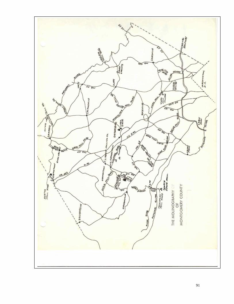
91