c h i n a - maps and data | unitarunosat-maps.web.cern.ch/unosat-maps/vn/fl20150730vnm/...t hed...

1
B inh K ieu B inh Hai B i Giang B i Con Thon B i Cho B ieu Nghi Cam Lo Cam La Phu Xa Phuc Le Pha Le Nhu Y Trung My Son My Dong Luong X am Lung Bac Lap Le Lac Thanh Ha Mo Cong Ha Lung Ha Doan Ha Doan Gia Duc Doan Le D ien Cong Phong Coc Luu K he Hung Hoc Hai Y en Dong Coc Chap K he Nam Phap Luc Hanh K ieu Son Khuong Lu Ha T ay Dong K he Doan Xa La K he Khoai Lac Dong L inh X am Bo V i K he V i Duong Trung Hanh Thuong Doan Quynh B ieu Y en Tr i Y en Hung Y en Dong Uong B i Tuy Lac Trung Ban Trang Kinh T hai K he Quynh Lau An K he 106 °51 ' 0 " E 106 °51 ' 0 " E 106 °48 ' 0 " E 106 °48 ' 0 " E 106 °45 ' 0 " E 106 °45 ' 0 " E 106 °42 ' 0 " E 21 °3 ' 0 " N 21 °3 ' 0 " N 21 °0 ' 0 " N 21 °0 ' 0 " N 20 °57 ' 0 " N 20 °57 ' 0 " N 20 °54 ' 0 " N 20 °54 ' 0 " N 20 °51 ' 0 " N 20 °51 ' 0 " N S at el l it e Dat a ( 1 ) : ALOS - 2 PALS AR - 2 I mager y Dat e: 31 Jul y 2015 R eso l ut ion : 6 . 25 m Copyr ight : JAXA Sour ce: JAXA S at el l it e Dat a ( 2 ) : ALOS - 2 PALS AR - 2 I mager y Dat e: 19 June 2015 R eso l ut ion : 6 . 25 m Copyr ight : JAXA Sour ce: JAXA Road Dat a: OpenS t reet M ap Ot her Dat a: USGS, UNCS, NAS A , NGA Anal y sis : UNI TAR- UNOSAT P roduct ion : UNI TAR- UNOSAT Anal y sis conduct ed wit h Ar cGI S v10 . 3 Coo rdinat e S yst em: W GS 1984 UTM Zone 46N P ro j ect ion : Tr ansverse M ercat o r Dat um: W GS 1984 Un it s: M et er T he depict ion and use o f boundar ies, geographic names and r el at ed dat a shown here are no t war an t ed t o be ero r - free no r do t hey impl y o f icial endo r semen t o r accept ance by t he Un it ed Nat ions. UNOSAT is a progr am o f t he Un it ed Nat ions I nst it ut e f o r Train ing and R esear ch ( UNI TAR) , pr oviding sat el l it e imager y and rel at ed geographic in fo r mat ion , r esear ch and anal y sis t o U N human it ar ian and devel opmen t agencies and t heirimpl emen t ing par t ners. T his wo rk by UNI TAR- UNOSAT is l icensed under a Creat ive Commons A t t r ibut ion - NonCommercial - S har eA l ike 3 . 0 Unpo r t ed L icense. Contact Information: [email protected] 24/7 Hotline: +41 76 487 4998 www.unitar.org/unosat T his map provides an overview o f sat el l it e det ect ed wat ers in Song L ch Tray del t a near Hai Phong C it y in no r t hern V iet nam. UNI TAR - UNOSAT iden t if ied 12 , 304 hect ares o f f l ood afect ed l and wit hin t he anal y zed region . A t o t al o f 7 anal y zed dist r ict s in t he provinces o f HaiPhong and Quang N inh were impact ed by t he f l oods. T he dist r ict o f Y en Hung in Quang N inh province was t he wo rst afect ed wit h 6 , 132 hect ares o f f l ooding, fo l l owed by T huy Nguy en dist r ict ( 2 , 671 ha) in Hai Phong province, and Hoanh Bo dist r ict ( 1 , 384 ha) in Quang N inh province. Approximat el y 25 k il omet ers o f roads were possibl y afect ed by f l ood wat ers in t he 7 anal y zed dist r ict s. Of t his t o t al , roughl y 9 . 2 k il omet ers were iden t if ied in t he dist r ict o f T huyNguy en , l ocat ed in Hai Phong province. I t is l ikel y t hat f l ood wat ers have been sy st emat ical l y underest imat ed al ong highl y veget at ed areas al ong main r iver banks, and wit hin buil t - up urban areas because o f t he special charact er ist ics o f t he sat el l it e dat a used. T his is a prel iminary anal y sis and has no t y et been val idat ed in t he f iel d. P l ease send ground feedback t o UNI TAR - U NOS AT. ¥ ¦ ¬ ¥ ¦ ¬ ¥ ¦ ¬ ¥ ¦ ¬ ¥ ¦ ¬ Vientiane Naypyidaw Bangkok Phnom Penh Hanoi Analysis with ALOS-2 PALSAR-2 Satellite Data Acquired on 31 July 2015 and 19 June 2015 Map Extent F P roduct ion Dat e: 8 / 25 / 2015 Version 2 . 0 G l ide Number : FL - 2015 - 000098 - VNM ! ! , Flooding FLOOD WATER EXTENT ANALYSIS (Satellite-Based Classification) P r obabl e St anding F l ood W at er s: [ ALOS PALS AR : 31 Jul y 2015 ] P r e- Cr isis W at er Ext en t [ ALOS PALS AR : 19 June 2015 ] ! I 0 0 . 5 1 1 . 5 2 Km Map Scale for A3: 1:80,000 Disaster coverage by the International Charter 'Space and Major Disasters'. For more information on the Charter, which is about assisting the disaster relief organizations with multi- satellite data and information, visit www.disasterscharter.org LEGEND Popul at ed Ar ea H ighway / Pr imar y Road Secondar y Road Local / Ur ban Road F l ood A f ect ed Road D ist r ict Boundar y H i Phòng Qu ng N i nh t H i H i An Ngô Quy n Th y Nguyên * Hoành B * Uông B í * Yên Hưng 462 917 29 2671 1384 709 6132 100% 100% 100% 54% 24% 66% 100% 4 . 89 6 . 95 0 . 94 9 . 21 1 . 92 0 . 27 1 . 17 Province District Land (ha) Roads (km) % Analyzed * Deno t es a par t ial l y anal y zed area Flooded Areas & Possibly Affected Roads in Analyzed Region CHINA

Upload: dinhnga

Post on 15-May-2018

222 views

Category:

Documents


2 download

TRANSCRIPT

!I

BinhK ieu

Binh Hai

Bi GiangBi ConT hon

Bi Cho

BieuNghi

Cam Lo

Cam La

Phu X a

Phuc Le

Pha Le

Nhu YT rung

M y S onM y Dong

LuongX amLung

Bac

Lap Le

LacT hanh

Ha M oCong

Ha Lung

Ha Doan

Ha Doan

Gia Duc

Doan Le

DienCong

PhongCoc

Luu K he

Hung Hoc

Hai Y en

Dong Coc

Chap K he

NamPhap

Luc Hanh

K ieu S on

K huong LuHa T ay

Dong K he

Doan X a

La K he

K hoaiLac

DongLinh

X am Bo

Vi K he Vi Duong

T rungHanh

T huongDoan

QuynhBieu

Y en T riY en Hung

Y en Dong

U ong Bi

T uy Lac

T rungBan

T rangK inh

T hai K he

QuynhLau

An K he106°51'0"E

106°51'0"E

106°48'0"E

106°48'0"E

106°45'0"E

106°45'0"E

106°42'0"E

21°3'0"N

21°3'0"N

21°0'0"N

21°0'0"N

20°57'0"N

20°57'0"N

20°54'0"N

20°54'0"N

20°51'0"N

20°51'0"N

S atellite Data (1) : ALOS -2 PALS AR -2Imagery Date: 31 July 2015R esolution: 6.25 mCopy right: JAX AS ource: JAX AS atellite Data (2) : ALOS -2 PALS AR -2Imagery Date: 19 June 2015R esolution: 6.25 mCopy right: JAX AS ource: JAX AR oad Data: OpenS treetM apOther Data: U S GS , U NCS , NAS A, NGAAnaly sis : U NITAR -U NOS ATProduction: U NITAR -U NOS ATAnaly sis conducted with ArcGIS v10.3Coordinate S y stem: W GS 1984 U T M Z one 46NProjection: T ransverse M ercatorDatum: W GS 1984U nits: M eterT he depiction and use of boundaries, geographicnames and related data shown here are notwarranted to be error-free nor do they imply officialendorsement or acceptance by the U nited Nations.U NOS AT is a program of the U nited Nations Institutefor T raining and R esearch (U NITAR ), providingsatellite imagery and related geographic information,research and analy sis to U N humanitarian anddevelopment agencies and their implementingpartners.T his work by U NITAR -U NOS AT is licensed under aCreative Commons Attribution-NonCommercial-S hareAlike 3.0 U nported License.

Contact Information: [email protected]/7 Hotl ine: +41 76 487 4998

www.unitar.org/unosat

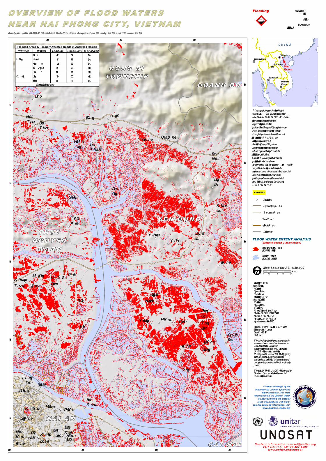
T his map provides an overview of satellite detectedwaters in S ong Lạch T ray delta near Hai Phong Cityin northern Vietnam. U NITAR -U NOS AT identified12,304 hectares of flood affected land within theanaly zed region. A total of 7 analy zed districts in theprovinces of Hai Phong and Quang Ninh wereimpacted by the floods. T he district of Y en Hung inQuang Ninh province was the worst affected with6,132 hectares of flooding, followed by T huy Nguy endistrict (2,671 ha) in Hai Phong province, and HoanhBo district (1,384 ha) in Quang Ninh province.Approximately 25 kilometers of roads were possiblyaffected by flood waters in the 7 analy zed districts.Of this total, roughly 9.2 kilometers were identified inthe district of T huy Nguy en, located in Hai Phongprovince. It is likely that flood waters have beensy stematically underestimated along highlyvegetated areas along main river banks, and withinbuilt-up urban areas because of the specialcharacteristics of the satellite data used. T his is apreliminary analy sis and has not y et been validatedin the field. Please send ground feedback toU NITAR -U NOS AT.

¥¦¬

¥¦¬

¥¦¬

¥¦¬

¥¦¬

¥¦¬

VientianeNaypyidaw

BangkokPhnomPenh

Hanoi

Analysis with ALOS-2 PALSAR-2 Satellite Data Acquired on 31 July 2015 and 19 June 2015

MapExtentF

Production Date:8/25/2015Version 2.0

Glide Number:FL-2015-000098-VNM!!,Flooding

FLOOD WATER EXTENT ANALYSIS(Satellite-Based Classification)Probable S tanding Flood W aters:[ALOS PALS AR : 31 July 2015]Pre-Crisis W ater Extent [ALOS PALS AR : 19 June 2015]

!I 0 0.5 1 1.5 2K m

Map Scale for A3: 1:80,000

Disaster coverage by theInternational Charter 'Space and

Major Disasters'. For moreinformation on the Charter, which

is about assisting the disasterrelief organizations with multi-

satellite data and information, visitwww.disasterscharter.org

LEGENDPopulated AreaHighway / Primary R oad

S econdary R oad

Local / U rban R oadFlood Affected R oadDistrict Boundary

Hải Phòng

Quảng Ninh

Cát HảiHải AnNgô QuyềnThủy Nguyên*Hoành Bồ*Uông Bí*Yên Hưng

46291729267113847096132

100%100%100%54%24%66%100%

4.896.950.949.211.920.271.17

Province District Land (ha) Roads (km) % Analyzed

*Denotes a partially analy zed area

Flooded Areas & Possibly Affected Roads in Analyzed Region C H I N A