by j. - international glaciological society · 2. stuhlmann, f. mit emin pascha im herz von afrika....
TRANSCRIPT
JOURNAL OF GLACIOLOGY
Nevertheless these facts were never quoted in connection with the Ruwenzori Range where they appear with remarkable diversity and intensity. Here we find polygonal networks of 'floating type," more or less deformed on sloping ground, stone stripes, solifluxion flows and several vegetation patterns such as hummocks, thurfur, tundra ponds and "coussins." The terrain in the neighbourhood of Lac Gris and L ac Blanc are quite representative in their aspects and, as a whole, one can point to a surprising similarity with the periglacial areas of the Icelandic glaciers, especially along the south coast of the island in summer. The soil structures they both show are quite different from those caused by frost action on the perenially frozen subsoil existing in periarctic countries.9
MS. received 13 October 1951
REFERENCES 1. Filippi , F. de. S.A.R. le Pri1lce Louise-A7IlMee de Savoie, Duc des Abruzzes. Le Ruwe1lzori. Voyage d'exploration. Trad.
A. Poizat. Paris, Pion, 1909. 2. Stuhlmann, F. Mit Emin Pascha im Herz von Afrika. Berlin, Dietrich R eimer, 1894. 3. (a) Grunne, X. de, a1ld others. Vers les glaciers de l'Equateur. Le Ruwe1lzori. Mission scientifique beige, 1932. Bruxelles,
R. Dupriez, 1937. [Anal. in Zeitschriftfur Gletscherkunde und Glazialgeologie, Bd. I, Ht. 2, 1950, p. 350.] (b) Jeannel, R. Hautes montagnes d'Mrique. Publications du Museum Natio1lal d'His/oire Naturelle (Paris), Supplement
No. 1, '950, iv, 253 p. 4. Humphreys, N. Ruwenzori: flj ghts and further exploration. Geographical Journal, Vol. 82, No. 6, '933, p . 48'-5'4. S. (a) Hicks, P. H. The Portal peaks of Ruwenzori. Geographical Journal, Vol. 108, Nos. 4-6, 1946, p. 210-20.
(b) Menzies, I. R. Some observations on the glaciology of the Ruwenzori range. Journal of Glaciology, Vol. 1, No. 9, 195 " p. 5 II-I2.
6. (a) Michot, P. Les traits caracteristiques de la morphologie du Ruwen zori dans leurs relations avec la tectonique du massif. Bulletin de la Societe Royale Beige de Geographie, Tom. 57, '933, p. 5-13.
(b) -- Les grandes lignes d e l'evolution geologique du Ruwenzori. Revue Universelle des Mines, Ser. 8, Tom. 9, No. 13, 1933.
7. (a) Geilinger, W. The retreat of the Kilimanjaro glaciers. Tanganyika Notes and Records, No. 2, Oct. 1936, p. 7-20. [Ref. Geographical Journal, Vol. 89, No. 4, 1937, p . 391-92.]
(b) Jaeger, F. Veranderungen der Kilimandjaro-gletscher. Zeitschrift fur Gletscherkunde, Bd. 19, 193 1, p. 285-99. (c) Nilsson, E. Traces of ancient changes of climate in East Africa. Geografiska Amzaler, Arg. 17, Ht. I, 1935, p. 1-121. (d) -- The pluvials of East Mrica. Geografiska Annaler, Arg. 3 1, Ht. 1-4, 1949, p. 204-11. (e) Salt, G. The Shira plateau of Kilimanjaro. Geographical Journal, Vol. II7, No. 2,'95', p. 150-66. (f) Spink, P. C. Further notes on the Kibo inner crater and glaciers of Kilimanjaro and Mount Kenya. Geographical
Journal, Vol. 106, Nos. 5-6, 1945, p. 210-16. (g) -- The equatorial glaciers of East Africa. Journal of Glaciology, Vol. I, No. 5, 1949, p. 277-81. (h) Troll, C., and Wien, K. Der Lewisgletscher am Mount Kenya. Geograjiska Annaler, Arg. 31, Ht. 1-4, '949,
P·257-74· (i) Klebelsberg, R. von. Handbuch der Gletscherkunde und Glazialgeologie. Wien, Springer-Verlag, 1948-49 . 2 vols.
8. (a) Troll, C. Strukturboden, Solifluktion und Frostklimate der Erde. Geologische Rundschau, Bd. 34, Ht. 7 /8, '944, p. 545-694. [Anal. by O. Jessen in Erdku1lde, Bd. I, Lfg. 4-6,1947, p. 228, and by E. Antevs in Joumal of Geology, Vol. 57, No. 2, 1949, p . 232.]
(b) -- Die Formen d er Solifluktion und die periglaziale Bodenabtragung. Erdkunde, Bd. 1, Lfg. 4-6 , 1947, p. 162-75 . 9. Rutten, M. G. Polygon soils in Iceland. Geologie e1l Mijnbouw, 13' Jaarg. , No. 5, 1951 , p. 161-67.
For further works of reference see bibliography in reference 3 (a) above. For report on older researches in the district see reference 3 (b). See also:
La Vallee Poussin, J. de. Les glaciers du Ruwenzori . An1lales de la Societe Scientijique de Bruxelles, Ser. B, Tom. 53, '933 , p. 45-47.
GLACIER WASTING AND RETREAT IN THE SOUTHERN ALPS OF NEW ZEALAND
By H. J. HARRINGTON
(New Zealand Geological Survey)
ANSTRACT. Down-wasting has affected southern glaciers in New Zealand later than northern glaciers under the influence of a southward rising snow line which is attributed to a southerly shift in prevailing wind belts. Evidence from the Hooker G lacier indicates that the present period of wasting is the fourth of a series which began about 200 years ago.
As the firn line rises a glacier is planed in the ablation zone so that successive surfaces are parallel to the original surface, which shows that ablation is more active for a short distance below the firn line than near the terminal face. A period of accelerated terminal retreat can result from parallel down-wasting without a correlative acceleration in the rate of climatic change.

GLACIER WASTING IN THE SOUTHERN ALPS OF NEW ZEALAND 141
ZUSAMMENFASSUNG. In Neuseeland werden siidliche Gletscher auf Grund einer sich siidwarts erhebenden Schneegrenze, die auf eine in vorherrschenden WindgiirteIn siidliche Verschiebung zuriickzufiihren ist, spater von einern Abschwinden beeinflusst als nordliche Gletscher. Beweis vorn Hooker Glacier zeigt an, dass die gegenwartige Periode des Schwindens die vierte einer Serie ist, die vor etwa 200 J ahren begann.
Mit dern Anwachsen der Firnlinie wird der Gletscher in der Ablationszone "abgehobelt", sodass aufeinanderfolgende Oberflachen rnit der urspriinglichen Oberflache paraIJel laufen, was darauf hinweist, dass Ablation auf einer kurzen Strecke unterhalb der Firnlinie wirksarner ist als nahe dern Gletscherende. Eine Periode beschleunigten Endriickzuges kann durch paraIJeles Abschwinden verursacht werden, ohne mit einer entsprechenden Beschleunigung irn Grade einer klirnatischen Anderung verbunden zu sein.
INTRODUCTION
In the Southern Alps of New Zealand glaciers occur along the Main Divide for a distance of 360 km. (225 miles) from Jervois Glacier just south of Milford Sound in lat. 44° 47' S. to the Arthur Pass area in lat. 42° 53' S. Permanent or nearly permanent snowfields occur for a further 145 km. (90 miles) to the north-east to Rainbow Saddle in Spenser Mountains. The extent and type of valley glaciation is similar to that in the Swiss Alps, but above the snow line the New Zealand peaks are often more heavily encrusted with iCe. Other general features of the New Zealand glaciers have been described recently in this Journal by Suggate 23 whose paper included a map showing the positions of the major groups of glaciers. The whole of the Southern Alps is also shown on a scale of I to 1 million in the Carte Internationale du Monde, and in more detail in the "Four Miles to an Inch" map series of the New Zealand Lands and Survey Department, while the major glaciers of the Mt. Cook region are shown on the map by Wicks.25
SUMMARY OF GLACIER CHANGES, AND THE IMPORTANCE OF DOWN-WASTING
(a) Loss of thickness and extension of ablation zone since 1866
A feature common to the trunk portions of all the major New Zealand valley glaciers 3,6,9,11,17,
18,29 is that they have been affected by down-wasting, which did not set in simultaneously on all, though it has progressed steadily on any given glacier after it has once started. On the Rangitata system of glaciers severe wasting was observed by Acland 1 between 1867 to 1880 and Wilson 27
noted that it was still continuing in 1934- In the Rakaia system wasting commenced at some time between von Haast's visit in 1865 and Speight's visit in 19II, and was still continuing at the time of the visit by Gage 8 in 1949. In the Mount Cook region the Tasman, Hooker and Mueller Glaciers were first observed by von Haast 12 in 1865 and were frequently observed and surveyed between 1884 and 1906. Although minor oscillations occurred there was no large change in the level of the ice during this time, except that Brodrick 4 noted 6 m. loss of thickness on the Mueller terminal between 1889 and 1906. However, Harper, 13 who was on the Tasman Glacier in 1905 and again in 1927, noted that strong down-wasting had occurred in the intervening period although he thought that it did not commence until after 1913 at De La Beche hut halfway up the glacier. Similarly Rose 19 thought that down-wasting on the Murchison Glacier did not commence until after 1914, and Harper 15 maintained that wasting on the Franz Joseph Glacier commenced some time before it did on the Fox.
It is noticeable that although all valley glaciers which descend to low levels have been greatly reduced in thickness, most of the ledge glaciers (hanging glaciers occupying long and narrow high ledges), ice falls and ice fields in the Mount Cook region have shown very little change or none at all. A good example of this is the Stocking Glacier which flows down the steep eastern face of the Mt. Sefton maSSIf towards the terminal faces of the Mueller and Hooker Glaciers. As its name implies the Stocking has a distinctive shape and no significant differences in it can be detected in photographs taken by Mr. J. H. Rose in 1913 and by the writer in 1951. A second example is that Harper 14 compared photographs of the Douglas Glacier taken from the same spot in 1894 and 1934 and stated that "there is remarkably little change in the upper ice fields, such as the Wicks and Morse Glaciers, or even in the great neve of the Douglas, but the trunk of the latter has shrunk materially in thickness .... "

JOURNAL OF GLACIOLOGY
In order to explain why wasting commenced earlier on some glaciers than on others, and why most high glaciers have not been affected by wasting, the hypothesis may be proposed that the snow line commenced to rise in the Rangitata area about 1866 or earlier, and that this trend slowly spread southwards until it had affected all parts of the Southern Alps by about 1913. A rising snow line caused a rising firn line on some glaciers and an extension of the ablation zone at the expense of the area of accumulation; in other words there was an advance up the affected glaciers of an "ablation front". As the snow line continued to rise an ablation front progressively attacked more glaciers and higher glaciers, but so far it has not risen quite far enough for attack to commence on most of the high ledge glaciers and steep hanging glaciers in the Mount Cook region. It may be noted that the relationship between the present snow line and the Pleistocene snow line has been studied by Willett.26
This hypothesis has yet to be proved but some support for it is given in the description by Gage 8 of the wasting of the Ramsay Glacier in the Rakaia system. Between 1865 and 19II downwasting amounted to 20 m. and was confined to the lower half of the glacier, but by 1949 it had spread up the glacier to above the Clarke junction 'and amounted to 60 m.
Fig. 2 . Longitudinal profile of a glacier tongue to show how the rate of terminal retreat is controlled by parallel down-wasting
SS .. Original surface of glacier S', S2, SJ .. Successive surfaces produced in the ablation zone by down-wasting; parallel to S except near
the firn-line F', F2, F3 . . Successive positions of rising firn-line
The rate of terminal retreat is slow while the firn-line rises from FI towards FJ, but accelerates when the base of the crevassed carapace under S3 meets either the bed of the glacier or the projected profile of its outlet stream . Note also that in the process of parallel down-wasting there is more rapid ablation a short distance below the firn-line than there is in the lower reaches of the ablation zone
(b) Terminal retreat since 1866
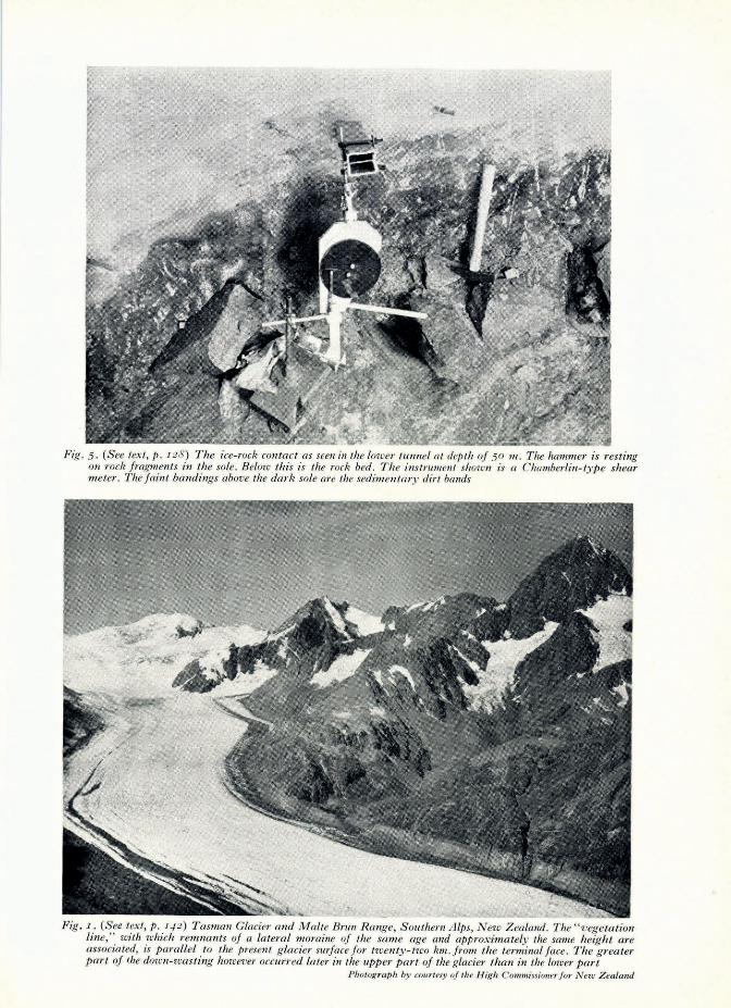
Down-wasting is common to all the major valley glaciers, but terminal retreat is much more erratic in amount, rate and time of occurrence, and this can be understood if consideration is given to the way in which loss of thickness occurs in the ablation zone. Gage 8 has described how Ramsay Glacier lost 20 m. of thickness in the terminal portion between 1865 and 19I1, and 60 m. in the middle reaches between 1910 and 1949; it should be noted that in this second period of observation the terminal zone did not also lose a further 60 m. but only 40 m. That is, ablation was more active below the firn line than at the terminal face, and the advancing ablation front planed the glacier so that the surfaces of 1949 and 1865 were parallel, except where they converged at the firn line. This type of "parallel down-wasting" is not peculiar to the Ramsay Glacier. It can be seen also on Godley, Murchison, Tasman, Hooker, Mueller and other glaciers where the present surface is parallel to sharp vegetation lines marking on the valley walls the maximum height attained by the ice before the present phase of down-wasting commenced (see Fig. I, p. 131).
If the surface of a glacier is being lowered annually by parallel down-wasting, then eventually the base of the crevassed carapace under one of the new surfaces will intersect the hed of the

GLACIER WASTING IN THE SOUTHERN ALPS OF NEW ZEALAND 143
glacier or the projected profile of its outlet stream, and if the intersection is at a very low angle (as it generally is) then there will be an accelerated retreat of the terminal face of the glacier as shown in Fig. 2 (p. 142). The time of commencement of this accelerated retreat will depend on the original thickness of the glacier above the projected profile of its outlet stream.
Thus the unusually large terminal retreat of 4·8.km. (3 miles) in the Fitzgerald and Separation Glaciers of the Godley system between the exploration by von Haast 12 in 1862 and the visit by Fletcher 7 in 1934 can be explained because both glaciers were thin and could be quickly removed by the parallel down-wasting that lowered the trunk of the main Godley Glacier by about 50 m. in the same time. This thinning of the main Godley trunk has also caused the collapse and retreat of its terminal for 2'4 km. (It miles), but on its neighbour the Classen and on other glaciers like the Tasman, Murchison and Mueller the ice above the bed of the outlet stream is still so thick that no large terminal retreat has yet occurred.
The occurrence of periods of minor terminal advance during a longer period of major retreat and wasting, as at Franz Josef Glacier, does not necessarily weaken the above theory because Speight 21 has noted that periods of minor advance on that fast-moving glacier can be predicted by observing waves of high ice advancing through the ablation zone. Suggate,23 too, has shown that they follow periods of additive excess of annual precipitation and deficit in annual mean temperatures. It seems that on a slow-moving glacier such waves are generally obliterated in the ablation zone before reaching the terminal face, but that on a fast-moving glacier they can reach the terminal face and cause a minor advance.
(c) Down-wasting and terminal retreat before 1862
Exploration of New Zealand glaciers by Europeans did not commence until about 1862 so that records of fluctuations before that date must be obtained from a study of moraines. Along the eastern side of the lower part of the trunk of the Hooker Glacier there are three distinct lateral moraines, and Brodrick stated that the uppermost of them is 235 ft. (72 m.) above the ice level of 1890, which in turn appears to be about the same height above the present ice level. From a vantage point such as the Kea Point Spur of Sealy Range each lateral moraine can be seen to be parallel to the present glacier surface, and each merges with a corresponding terminal moraine. These moraines indicate that down-wasting had gone on for a long time before 1866, and that it must have occurred in three main phases separated by periods of stability or slight expansion . .
To estimate the age of the uppermost Hooker moraine we have to go to the adjoining Mueller terminal where there is a large latero-terminal moraine called White Horse Hill which may be correlated with one or more of the three upper moraines of the Hooker. On the inner slope of White Horse Hill there is a distinct vegetation line marking the maximum height of the ice in the period 1866-1906, and on the outer slope there was formerly an alpine bush or forest covering which was accidentally destroyed by fire about 1891. It is said that the dominant tree was mountain totara (Podocarpus sp.) which is again growing in the area, and afte~ the fire the stumps and logs that remained were used for fuel at the Old Hermitage.
In June 1951 the writer was told by Mr. J. Adamson, who was manager of the Old Hermitage from 1885 to 1897, that many of the stumps and logs were up to a foot (30 cm.) in diameter, and he pointed out a place low on the outer slope of the moraine where he had found one stump 4 ft. 6 in. (1'37 m.) in diameter. Mr. Peter Graham, who was Chief Guide at the Hermitage some years after the fire, did not remember clearly the size of the logs but he thought that they "might have been a foot in diameter." The trees were growing at the upper limit of the forest zone and it is likely from their size that they were about 150 years old in 1891, and therefore that the lower outer slope of White Horse Hill and the uppermost or No. 3 lateral moraine of the Hooker were formed no later than 1741, and might be much older.
It appears therefore that at least one glacier, the· Hooker, has been lowered in height in the terminal zone for at least 200 years, though the process was interrupted by four periods of stability or slight expansion marked by the" 1890" moraine and the three higher moraines. It seems very

144 JOURNAL OF GLACIOLOGY
probable that a similar record of changes would be obtained from a study of the series of moraines and vegetation lines described by Douglas 5 on the Strauchon Glacier, by Brodrick 2 on the Baker Glacier of the Murchison system, and by Speight 22 on the Fox and Franz J osef Glaciers.
CLIMATIC CAUSES OF GLACIER WASTING IN NEW ZEALAND
Seelye 20 has concluded that the annual rainfall indices "for 1863 to 1947 show a declining tendency at the average rate of at least four per cent and two per cent per century for the North and South Islands respectively, but such a trend implies a bias in the method of evaluating indices before 1890 and a reasonable adjustment increases these trend rates to about seven and three per cent per century."
Mr. C. A Fleming 28 has informed the writer that "on the Wanganui coast fixed sand-dunes provide evidence of changes in the direction of the dominant sand-moving winds. Sand is now moved north-east by almost equally strong southerlies and westerlies. At an earlier Recent period sand moved eastward, with negligible southerly influence. At a still earlier stage southerlies dominated over westerlies. It is tempting to correlate the three periods with the Sub atlantic, Atlantic and Boreal periods recognized from pollen studies."
It appears likely, therefore, that in New Zealand, as in the Northern Hemisphere, changes in the circulation of the atmosphere have probably been largely responsible for Recent glacier wasting and retreat. As noted by Kidson 16 and Watts 24 New Zealand lies between the high-pressure belt of the sub-tropics and the low-pressure belt of the Southern Ocean, but nearer the former than the latter. 10 The weather is thus controlled by the series of anticyclones in the warm, moist, slowmoving tropical stream that moves eastward from Australia, and the cold fronts and depressions which develop along the great discontinuity between this stream and the cold, dense, fast-moving polar flow. A secular movement to the south of the average position of this discontinuity would have several effects that could cause glacier wasting. There would be rising temperatures through the increased influence of warm north-westerly and westerly winds over cold southerly winds, and there might also be a long-term decreasing rainfall trend. This hypothesis possibly explains and is supported by the fact that the decreasing rainfaH trend that was detected by Seelye 20 is greater in North Island than in South Island.
ACKNOWLEDGEMENTS
In the collection of material for this paper I have received valuable help from discussions with Messrs. David Hall, G. C. N. Johnston, 1. C. McKellar, J. H. Rose and other members of the New Zealand Alpine Club. The manuscript was read by Mr. M. Gage and Professor N. E. Odell.
MS. received IS October 1951
REFERENCES I. Acland, J. B. A. Early Explorations at the Headwaters of the Rangitata River. New Zealand Alpine Journal, 1892,
Vol. " No. " p. 22-29. 2. Brodrick, T. N. Report on the Tasman Glacier. Appendix to Journal of House of R epresentatives of New Zealand,
1891, Session n, Vol. I, C-,A, Appendix No. 4, p. 39-43. 3. -- Ice Motion of the Canterbury Glaciers. New Zealand Alpine Joumal, 1894, Vol. I, No. 6, p. 307-315. 4. - - Glacier Movements . Appetldix to Journal of House of Representatives of New Zealand, 1906, Session H, Vol. I,
C lA, Appendix No. 2 , p. ,6-17. 5. Douglas, C. E. Explorations Made Along the Copland River . Appendix to Journal of House of Representatives of New
Zealand, 1892, C-l, Appendix No. 3, p . 42-47. 6. -- Report on Cook's River District. Appendix to Journal of House of Represetltatives of New Zealand, 1896 , C-I,
Appendix No. 7 , p. 110-12.
7. Fletcher, T. A. The Godley Peaks. New Zealand Alpine Joumal, 1921, Vol. 3. 8. Gage, M. The Dwindling Glaciers of the Upper Rakaia Valley, Canterbury, New Zealand. Journal of Glaciology,
195 1, Vol. I, No. 9, p. 504. 9. -- The Cameron Glacier, Arrowsmith Range, Canterbury. New Zealand Journal of Science and Technology . (In
the Press.) 10. Gamier, B. J. , and Others . New Zealand Weather and Climate. Whitcombe and Tombs Ltd., 1950, 154 p. 11. Green, W. S. The High Alps of New Zealand, London: Macmillan, 1883. 12. Haast. l.von. Geology of the Provinces of Canterbury and Westland. Christchurch, New Zealand, 1879 .

GLACIER WA STING IN THE SOUTHERN ALPS OF NEW ZEALAND 145 13. Harper. A. P. Glacier Retreat. New Zealand A lpine Journal, '934, Vo!. 5, No. 21, p. 322-26. '4. -- Note on G lacier R etreat. New Zealand A lpine Journal, '935 , Vo!. 6, No. 22, p. '73. 15. -- M emories of M ountains and Men. Simpson and Williams Ltd. Christchurch, New Zealand, 1946, Appendix I,
p. '92-97. 16. Kidson, E . The Elements of New Zealand's Climate. (Chapter 3 of Garnier and Other s , 1950 (reference 10 above).) 17. Park, George. Explorations of the Glacier Sources of the Kallery River. Nezu Zealand A lpine Journal , 1892, Vo!. I,
No. 2, p . 90-96. 18. Riddiford , H . E. A Visit to the Douglas. New Zealand A lpine JOtlmal, '947, Vo!. 12, No. 34, p. 43- 52. 19. Rose, J. H . Recent R etreat of Murchison Glacier. New Zealand Journal of Science alld Technology , '937, Vo!. 19,
No. 7, p . 45 3-57· 20. Seelye, C. I. Fluctuations and Secular Trend of New Zealand R ainfall. New Zealand Journal of Science and Tech
nology, Vo!. 31 , Section B, No. 6, ' 950, p. IJ -24. 2 1. Speight, R. Recent Changes in the T erminal Face of the Franz J osef Glacier. Transactions New Zealand Institute,
Vo!. 53 , 1921, p. 53-57· 22. -- Notes on the Franz I osef G lacier , D ecember, 1940. Transactions Royal Society of New Zealand, Vo!. 71. 23. Suggate, R. P . Franz I osef and Other Glaciers of the Southern Alps, New Zealand . Joumal of Glaciology, Vo!. J:
No. 8 , 1950, p. 422-29 . 24. Watts,!. E. M. Forecasting New Z ealand W eather. New Zealand Geographer, Vo!. I, No. 2, ' 945 , p . IJ9-38.
(Chapter 2 in Garnier and Others (reference 10 above).) 25 . Wicks, A. I . Map of Alpine Regions in Vicinity of Mount Cook. New Zealand Lands and Survey D epartment, W elling
ton. 26. Willett, R. W . The New Zealand Pleistocene Snow Line, Climatic Conditions, and S uggested Biolog ical Effects.
New Zealand J ournal Science and Technology, Section B, Vo!. 32, No. I , 1950, p. 18-48. 27. Wilson, L . K. Peaks and Peregrinations in the Tribut:fries of the C lyde. New Z ealand Alpille J ournal, Vo!. 5, No. 2 r,
'934, p . 347- 66. 28. Fleming, C. A. Some Post-Miocene C hanges in New Zealand Environments. New Zealand Science R eview. (In the.
Press.) 29. Russell, R. S. Note on Glacier-Recess ion in the Landsborough and Twain Valleys, South \Vestland . Transactio1ls
Royal Society of New Zealand, Vo!. 66, 193 6, p. 78- 79.
REVIEWS
ZEITSCHRIFT FUR GLETSCHERKUNDE UND GLAZIALGEOLOGIE.* (R. von Klebelsberg, Ed.) Innsbruck: Universitiits-Verlag Wagner, Band 2, H eft I , 1952, 171 p.
As noted in the review on page 397 of Vo!. 1 of the Journal of Glaciology, the Zeitschrift fiir Gletscherkunde und Glazialgeologie is continuing periodic publication since its first post-war issue of 1949·
The present number measures up to the fine quality and broad range of glacial morphological and glaciological articles covered by previous issues. These include subjects ranging from aspects on the internal structure and facings of glaciers and their firn cover, to discussions more strictly geographical and geomorphological in emphasis. Some of the material presented is obviously still a backlog of field work which has not been fully drawn to our attention elsewhere owing to the interference of the last war. Several papers of interest concerning new studies in seldom discussed regions are given. These include an interesting paper on glaciological research on the moraines at high elevations on two mountains in central Greece, and another interesting piece on penitente ice formations in the San Juan Cordillera of Argentina.
The previous pattern of reports on glacier variations in Europe is followed to bring the record up to date through 1950. And, as always, there are valuable short notes and discussions on individual matters and on other recent publications of glaciological interest.
Although this Journal is, as usual, well presented, a few diagrams would seem not to be up to its usual standard of precise draughtsmanship. Also it might be added that a short abstract either in English or French would be most useful at the beginning of each paper, and in any event a short abstract in G erman, also at the beginning of each article, would be of greatest assistance.
American Geographical Society, New York
MAYNARD M . . MILLER
.. This publication can be obtained at the Barmerlea Book Sales Ltd., 10, Bayley Street, Bedford Square, London, W.C.I, at a price of 95 Austrian schillings .
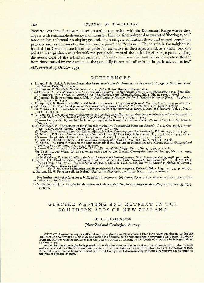
.. Fig. 5. (See text, p. I 28 ) The ice-rod? contact as seen ill the lower tllllllel at depth oj 50 111 . The hammer is res ting
on roe" jragments in the sole. Below this is the roe" bed . The instrument shown is a Chamberlil1-type shear m eter. The faint bandings above the dar" sole are the sedilllentary dirt bands
Fig . I. (See text, p. I12) Taslllan GladeI' and Malte B1'I111 R ange, S outhern A lps , N ew Z ealand. The "vegetation line," with which remllants of a lateral moraine oj the some age and app,·oxi1llately the same height are associated, is parallel to the p"esellt glacier swjacefo,' twen ty -two "m.Fo1/! the terminal fa ce. The greater pm·t oj (he dozen-wasting however ocmrred later in the I.,.ppe,· part oj the glader than in the lower part
Photograph by courtesy of the Hig h Commissioner Im' New Z ealand