bushfire assessment report
TRANSCRIPT
PO Box 495 Unit 2, 10-11 Ferguson Road Springwood NSW 2777 T (02) 4751 9487
Abel Ecology Pty Ltd E [email protected] 2 Samuel 20:18 ACN 079 079 762 – ABN 72 516 253 751 www.abelecology.com.au
Abel Ecology
Bushfire assessment report for Honeycomb Drive, Eastern Creek Lots 2 and 3, DP 1145808 Proposed Energy from Waste Facility, Eastern Creek (SSD 6236).
Date: 22 September 2017
Document No: 1817-REP-ISS-2
Prepared for: The Next Generation NSW Pty Ltd (TNG NSW)
Prepared by: Abel Ecology
22 September 2017 Issue 2 Page 2 of 24
AE17 REP 1817 ISS-2 22Sep17.docx © Abel Ecology Pty Ltd, 2017 AD AE17 REP 1817 ISS-2 22Sep17.docx © Abel Ecology Pty Ltd, 2017 AD
Disclaimer
This report has been prepared in accordance with the scope of services described in agreement between Abel Ecology and the Client. In preparing this report, Abel Ecology has relied upon data, surveys and site inspection results taken at or under
the particular time and or conditions specified herein. Abel Ecology has also relied on certain verbal information and documentation provided by the Client and/or third parties, but did not attempt to independently verify the accuracy or completeness of that information. To the extent that the conclusions and recommendations in this report are based in whole or in part on such information, they are contingent on its validity. Abel Ecology assumes no responsibility for any consequences arising from any information or condition that was concealed, withheld, misrepresented, or otherwise not fully disclosed or available to Abel
Ecology. The findings contained in this report are the result of discrete/specific methodologies used in accordance with normal practices and standards. To the best of our knowledge, they represent a reasonable interpretation of the general condition of the site in question. Under no circumstances, however, can it be considered that these findings represent the actual state of the site/sites at all points.
Any representation, statement, opinion or advice, expressed or implied in this publication is made in good faith but on the basis that Abel Ecology, its agents and employees are not liable (whether by reason of negligence, lack of care or otherwise) to any person for any damage or loss whatsoever, which has occurred or may occur in relation to that person taking or not taking (as the case may be) action in respect of any representation, statement, or advice referred to above. Any findings, conclusions or recommendations only
apply to the aforementioned circumstances and no greater reliance should be assumed or drawn by the Client. Furthermore, this report has been prepared solely for use by the Client. Abel Ecology accepts no responsibility for its use by other parties.
Document history
Report Version Prepared by Checked by Submission
Method Date
Final report Issue 1 Dr Danny Wotherspoon Email 19 Sep 17
Final report Issue 2 Dr Danny Wotherspoon
Dr Daniel McDonald
Steven Smith Email 22 Sept 17
22 September 2017 Issue 2 Page 3 of 24
AE17 REP 1817 ISS-2 22Sep17.docx © Abel Ecology Pty Ltd, 2017 AD AE17 REP 1817 ISS-2 22Sep17.docx © Abel Ecology Pty Ltd, 2017 AD
TableofContents
Executive Summary .......................................................................................................................................... 121. Introduction ................................................................................................................................................ 131.1 Planning relationships .................................................................................................................................. 131.1.1Legislation ............................................................................................................................................................................................... 131.2 Literature Review ......................................................................................................................................... 132. The site and proposed development ....................................................................................................... 142.1 Existing site description ................................................................................................................................ 142.2 Existing vegetation description .................................................................................................................. 142.3 The proposal ................................................................................................................................................. 142.4 Significant environmental features ............................................................................................................ 162.5 Threatened flora and fauna ...................................................................................................................... 162.6 Archaeological and Heritage Significant sites ........................................................................................ 163. Survey method ........................................................................................................................................... 164. Assessment of bushfire hazard ................................................................................................................. 175. Issues arising from the assessment ........................................................................................................... 185.1 Threat ............................................................................................................................................................ 185.2 Protection criteria ........................................................................................................................................ 185.3 Analysis ......................................................................................................................................................... 185.4 Management strategies ............................................................................................................................. 186. Infrastructure and other requirements ..................................................................................................... 196.1 Asset Protection Zone management ........................................................................................................ 196.2 Access and egress ...................................................................................................................................... 196.3 Availability of fire fighting services ............................................................................................................. 206.4 Landscaping ................................................................................................................................................ 207. Building construction requirements .......................................................................................................... 207.1 Ember attack ............................................................................................................................................... 207.2 Radiant heat ................................................................................................................................................ 207.3 Direct flame .................................................................................................................................................. 207.4 Smoke plume ............................................................................................................................................... 218. Conclusion and recommendations ......................................................................................................... 21Appendix 1. Glossary of Definitions and Terms ........................................................................................... 22Appendix 2. Company Profile ...................................................................................................................... 24
22 September 2017 Issue 2 Page 4 of 24
AE17 REP 1817 ISS-2 22Sep17.docx © Abel Ecology Pty Ltd, 2017 AD AE17 REP 1817 ISS-2 22Sep17.docx © Abel Ecology Pty Ltd, 2017 AD
TableofFigures
Figure 1. Locality map for Lots 2 and 3 DP 1145808, Honeycomb Drive, Eastern Creek. ............................. 5Figure 2. Air photo of the site and local area. ................................................................................................... 6Figure 3. Proposal Diagram building layout. ...................................................................................................... 7Figure 4 Air photo of the site with 140 assessment area. .................................................................................. 8Figure 5. Site vegetation showing forest upstream of the site in the south east corner. .............................. 9Figure 6. Bush Fire Prone Land map. ................................................................................................................. 10Figure 7. Swamp forest to the south east. ........................................................................................................ 11
ListofAbbreviations APZ Asset Protection Zone IPA Inner Protection Area OPA Outer Protection Area
PBP 2006 Planning for Bushfire Protection 2006
Note regarding maps in this report The diagrams/site maps used in this report have been supplied by and are used with the permission of at & l.
With regard to maps provided by the Land Information Centre, Topographic maps used with the permission of © Land and Property Information, NSW, www.lpi.gov.au
22 September 2017 Issue 2 Page 5 of 24
AE17 REP 1817 ISS-2 22Sep17.docx © Abel Ecology Pty Ltd, 2017 AD AE17 REP 1817 ISS-2 22Sep17.docx © Abel Ecology Pty Ltd, 2017 AD
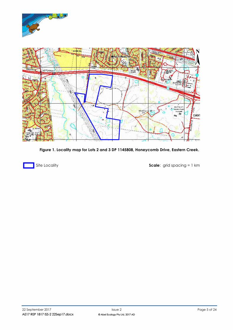
Figure 1. Locality map for Lots 2 and 3 DP 1145808, Honeycomb Drive, Eastern Creek.
Site Locality Scale: grid spacing = 1 km
N
22 September 2017 Issue 2 Page 6 of 24
AE17 REP 1817 ISS-2 22Sep17.docx © Abel Ecology Pty Ltd, 2017 AD AE17 REP 1817 ISS-2 22Sep17.docx © Abel Ecology Pty Ltd, 2017 AD
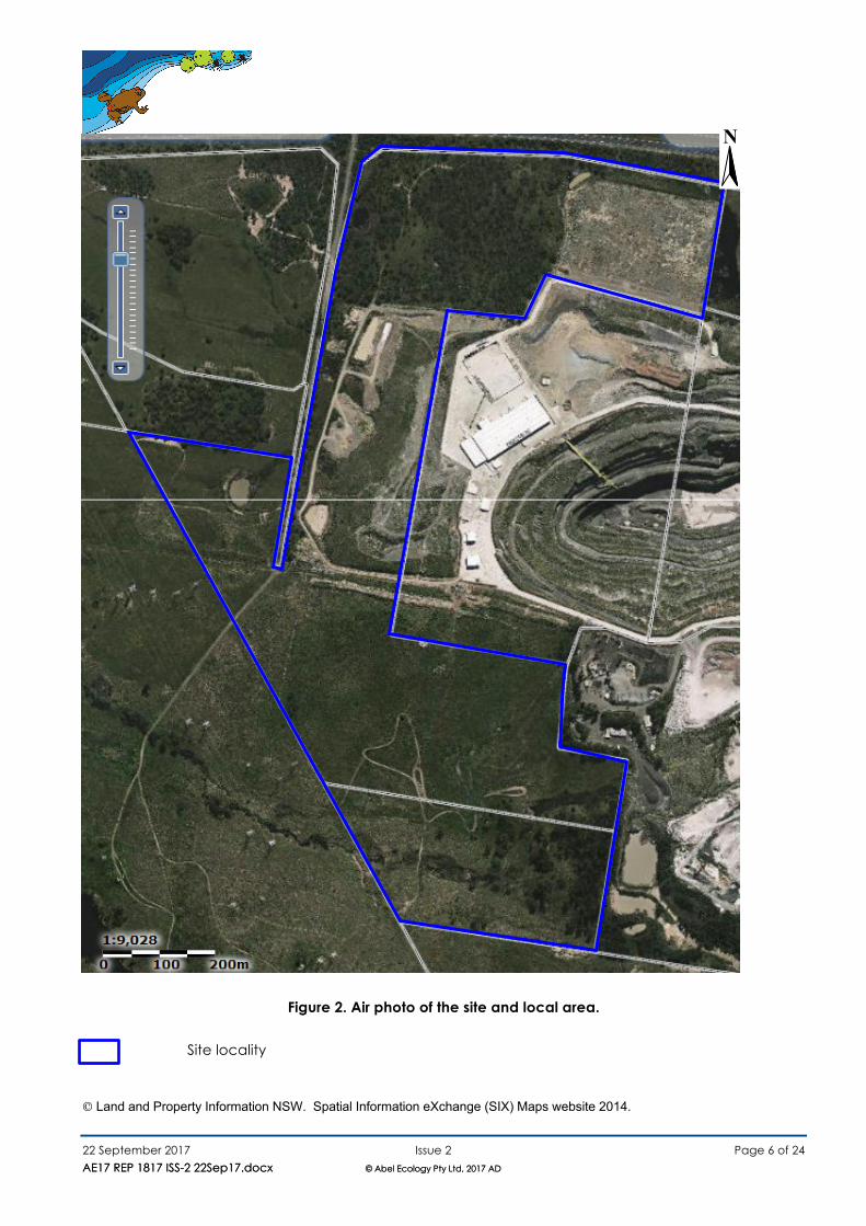
Figure 2. Air photo of the site and local area. Site locality
© Land and Property Information NSW. Spatial Information eXchange (SIX) Maps website 2014.
N
22 September 2017 Issue 2 Page 7 of 24
AE17 REP 1817 ISS-2 22Sep17.docx © Abel Ecology Pty Ltd, 2017 AD AE17 REP 1817 ISS-2 22Sep17.docx © Abel Ecology Pty Ltd, 2017 AD
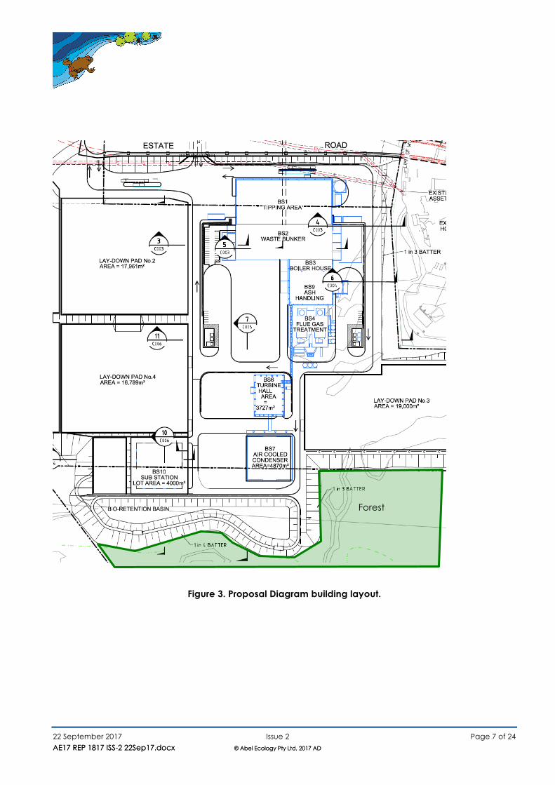
Figure 3. Proposal Diagram building layout.
Forest
22 September 2017 Issue 2 Page 8 of 24
AE17 REP 1817 ISS-2 22Sep17.docx © Abel Ecology Pty Ltd, 2017 AD AE17 REP 1817 ISS-2 22Sep17.docx © Abel Ecology Pty Ltd, 2017 AD
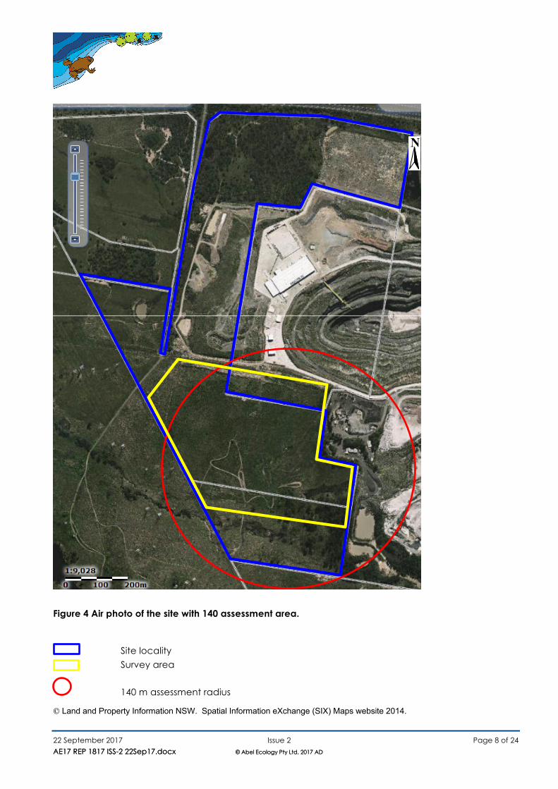
Figure 4 Air photo of the site with 140 assessment area.
Site locality
Survey area 140 m assessment radius
© Land and Property Information NSW. Spatial Information eXchange (SIX) Maps website 2014.
N
22 September 2017 Issue 2 Page 9 of 24
AE17 REP 1817 ISS-2 22Sep17.docx © Abel Ecology Pty Ltd, 2017 AD AE17 REP 1817 ISS-2 22Sep17.docx © Abel Ecology Pty Ltd, 2017 AD
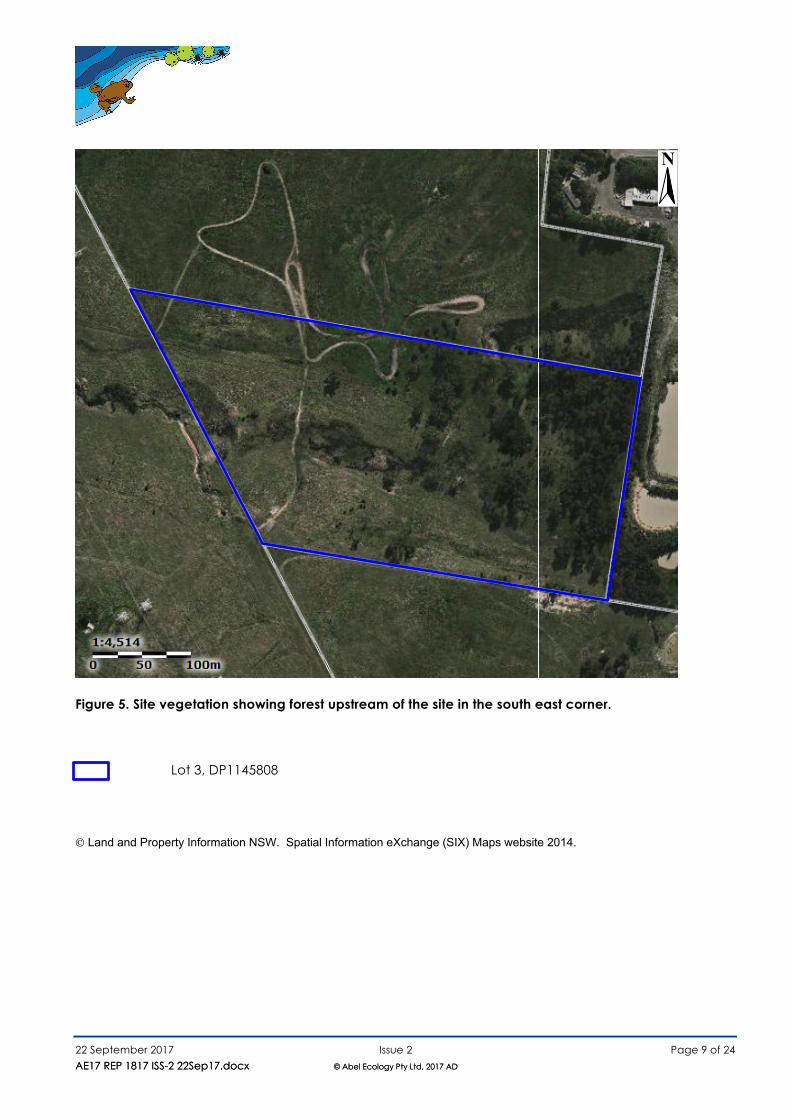
Figure 5. Site vegetation showing forest upstream of the site in the south east corner.
Lot 3, DP1145808
© Land and Property Information NSW. Spatial Information eXchange (SIX) Maps website 2014.
N
22 September 2017 Issue 2 Page 10 of 24
AE17 REP 1817 ISS-2 22Sep17.docx © Abel Ecology Pty Ltd, 2017 AD
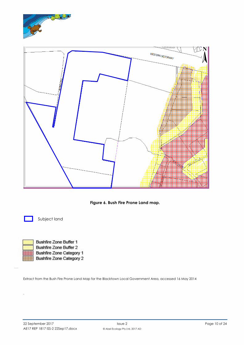
Figure 6. Bush Fire Prone Land map.
Subject land
Extract from the Bush Fire Prone Land Map for the Blacktown Local Government Area, accessed 16 May 2014 .
N
22 September 2017 Issue 2 Page 11 of 24
AE17 REP 1817 ISS-2 22Sep17.docx © Abel Ecology Pty Ltd, 2017 AD
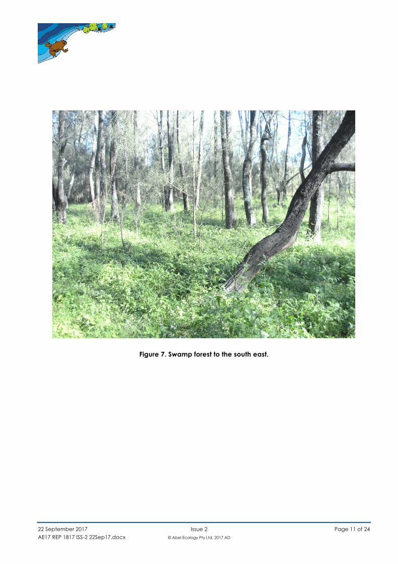
Figure 7. Swamp forest to the south east.
22 September 2017 Issue 2 Page 12 of 24
AE17 REP 1817 ISS-2 22Sep17.docx © Abel Ecology Pty Ltd, 2017 AD
ExecutiveSummary
A bushfire assessment of the proposed development, an Energy from Waste Facility, Eastern Creek
(SSD 6236) at Lots 2 and 3, DP 1145808, (‘the site’ -Figure 1 ) was undertaken on 23, 24 April 2014. The development application is to erect an energy from waste facility and industrial subdivision of the land.
The vegetation hazard that will most significantly influence fire behaviour is the Forest to the south east and south.
The aim of the assessment was to ascertain the potential fire hazard and establish the site capability for an Asset Protection Zone to protect staff and facilities.
The access road to the building footprint from Honeycomb Road is adequate for fire fighting access and emergency staff egress.
The site has significant vegetation as an endangered ecological community. The site has threatened flora or fauna species in the form of two species of insectivorous bats (Abel
Ecology Flora and Fauna report dated May 2014). The following conclusions and recommendations apply: In our opinion, the site is not sterilised by the bushfire threat. The owners will therefore be able to
construct the proposed facility with the following measures included:
a) Building construction for all aspects of the buildings excluding windows will need to be minimum FRL 30/30/30 where separation of 55m from forest is not achieved;
b) Openable portions of windows are to be screened with metal mesh maximum 2mm aperture, where separation of 55m from forest is not achieved;
c) Water requirements. Fire hose reels must be provided, which is capable of reaching all extremities
of the proposed development.
d) Grass batters between the facility and forest are to be mown as lawn.
22 September 2017 Issue 2 Page 13 of 24
AE17 REP 1817 ISS-2 22Sep17.docx © Abel Ecology Pty Ltd, 2017 AD
1. Introduction
We have been engaged by The Next Generation NSW Pty Ltd (TNG NSW) to prepare a bushfire
assessment for Stage 1 of an industrial development (Figure 3). We have perused the details sent to us and completed a detailed inspection of the site. This report
serves to:
a) identify the site and proposed development,
b) determine the bushfire threat, and
c) identify work required to be completed in order to improve the chances of building survival in the event of a bushfire. These works will satisfy the Performance Requirements of BCA.
The proposed development of an energy from waste facility comprises buildings and structures for
electrical transmission. Parts of the site are proposed for construction of industrial buildings of various styles. The surrounding environment comprises grasslands and forest. The forest is on an alluvial flat, with a weedy understorey. The forest off site to the east is to be retained and extended to within 30
metres of the proposed buildings. This analysis anticipates that at least part of the development may be exposed to potential wildfire in
forest.
1.1 Planning relationships
1.1.1 Legislation
a) Rural Fires Act 1997 (amended) s.63(1), 63(2), 100B
b) Section 79C(1)(c) EP & A Act c) Section 117 EP & A Act
1.2 Literature Review
Standards Australia (2009) AS 3959, Construction of buildings in bushfire-prone areas, Standards Australia, Sydney.
Cumberland Zone Bushfire Risk Management Plan 2010
Keith, D. (2004) Ocean shores to desert dunes: the native vegetation of New South Wales and the
ACT. Department of Environment and Conservation (NSW), Hurstville.
22 September 2017 Issue 2 Page 14 of 24
AE17 REP 1817 ISS-2 22Sep17.docx © Abel Ecology Pty Ltd, 2017 AD
2. Thesiteandproposeddevelopment
2.1 Existing site description
On Site
The site is identified as Lots 2 and 3, DP 1145808 (Figure 1)
The site is accessed directly from Honeycomb Road.
Adjacent Properties
Adjacent land uses (Figure 2) are as follows: North: developed industrial;
West: grazed grassland; South: grazed grassland; and East: developed industrial and riparian forest on a watercourse.
2.2 Existing vegetation description
On Site
The vegetation description is according to Table A2.1 ‘Classification of Vegetation Formations’ in PBP
2006 based on Keith, 2004. The vegetation in the area is grassland and forest (Figure 5).
Adjacent Properties
Grasslands to the west and south are lightly grazed so are regarded as unmanaged grasslands for the purpose of assessing fuel load and fire hazard.
Riparian forest along the watercourse to the south east is regarded as forest.
2.3 The proposal
The proposal is to clear all vegetation within the site for industrial development, leaving grasslands to
the west and south and riparian forest to the south east (Figure 4). The grassland to the south will be revegetated as a riparian forest along the creek.
The proposed development involves the construction of an Energy from Waste (EFW) Electricity Generation Plant for The Next Generation NSW Pty Ltd (TNG) in Eastern Creek, approximately 36km west of the Sydney CBD.
The development involves the construction and operation of an Electricity Generation Plant, which will allow for unsalvageable and uneconomic residue waste from the Genesis Xero Material Processing Centre (MPC) and Waste Transfer Station (WTS) to be used for generation of electrical power. The EFW
Plant is proposed to be located on Lots 2 and 3, DP 1145808.
22 September 2017 Issue 2 Page 15 of 24
AE17 REP 1817 ISS-2 22Sep17.docx © Abel Ecology Pty Ltd, 2017 AD
The plant, powered by burning non-recyclable combustible waste material, will have a nominal operational input of 552,500 tonnes of waste material per annum from waste already being received at the neighbouring Genesis Xero Waste Facility. The proposal will include the complete construction
of the Tipping Hall and Waste Bunker and combustion Lines 1 and 2 comprising of two independent Boilers, Flue Gas Treatment (FGT) systems, Stack as well as one Turbine and one Air Cooled Condenser (ACC) and all other auxiliary equipment.
The proposed EFW Facility will employment of a total of up to 55 staff upon operation, working over 3 shifts (i.e. not on site at any one time).
The project is identified as State Significant Development (SSD) under Schedule 1 of the State Environmental Planning Policy (State and Regional Development) 2011 being:
Cl. 20 Electricity generating works and heat or co-generation: Development for the purpose of electricity generating works or heat or their co-generation (using any
energy source, including gas, coal, biofuel, distillate, waste, hydro, wave, solar or wind power) that: (a) has a capital investment value of more than $30 million, or (b) has a capital investment value of more than $10 million and is located in an environmentally
sensitive area of State significance The proposal has a capital investment value of greater than $30 million and therefore is classified as a State Significant Development.
The site which is accessed off Honeycomb Drive at Eastern Creek is surrounded by land owned by the Corporate Group Alexandria Landfill Pty Ltd, ThaQuarry Pty Ltd, Australand, Hanson, Jacfin, the
Department of Planning and Infrastructure and Sargents. The site and surrounding land is identified as part of the ‘State Environmental Planning Policy (Western Sydney Employment Area) 2009 (WSEA SEPP)’ to be redeveloped for higher end industrial and employment uses over the next decade. The
site has a total area of approximately 56 Ha including the Riparian Corridor, with a specific development area circa 9 Ha. The proposed works will, in addition to the Energy from Waste Electricity Generation Facility, include
the adoption of a plan of subdivision and the following ancillary works: • Earthworks associated with the balance of the site; • Internal roadways;
• Provision of a direct underpass connection (Precast Arch and Conveyor Culvert) between TNG Facility and the Genesis Xero Waste Facility;
• Staff amenities and ablutions;
• Staff carparking facilities; • Water detention and treatment basins; • Services (Sewerage, Water Supply, Communications, Power Supply).
22 September 2017 Issue 2 Page 16 of 24
AE17 REP 1817 ISS-2 22Sep17.docx © Abel Ecology Pty Ltd, 2017 AD
Further to the above physical works associated with the proposed Energy from Waste Facility, this application seeks approval for the subdivision Lot 1, 2 and 3 in DP 1145805 in order to create a separate lot of 10,000 m² for the Transgrid Switching or Substation and additional lots to allow for future
development of land not associated with the Energy from Waste Facility and the Genesis Xero Material Processing Plant.
2.4 Significant environmental features
The riparian zone runs from the south east corner along the south of the site. A patch of forest on the watercourse (Figure 7) has habitat in the form of hollow trees for threatened species of microbats that were recorded as being present on the site.
2.5 Threatened flora and fauna
Two threatened species of microbats were recorded as being present on the site. The vegetation is an endangered ecological community. No part of the land has been identified as critical habitat.
2.6 Archaeological and Heritage Significant sites
Abel Ecology is not aware of Heritage Significant sites on the land. Abel Ecology is not aware of Aboriginal relics on the land.
3. Surveymethod
Survey methods (Figure 4) were applied in accordance with assessment methodology set in Appendix 2/3 of PBP 2006 and Table 2.4.2 of AS 3959. The site is near bushfire prone land (Figure 6). Calculations have been done using the AS3959 algorithm in the Abel Ecology calculator.
See Appendix 1 for definitions of fire management terminology.
22 September 2017 Issue 2 Page 17 of 24
AE17 REP 1817 ISS-2 22Sep17.docx © Abel Ecology Pty Ltd, 2017 AD
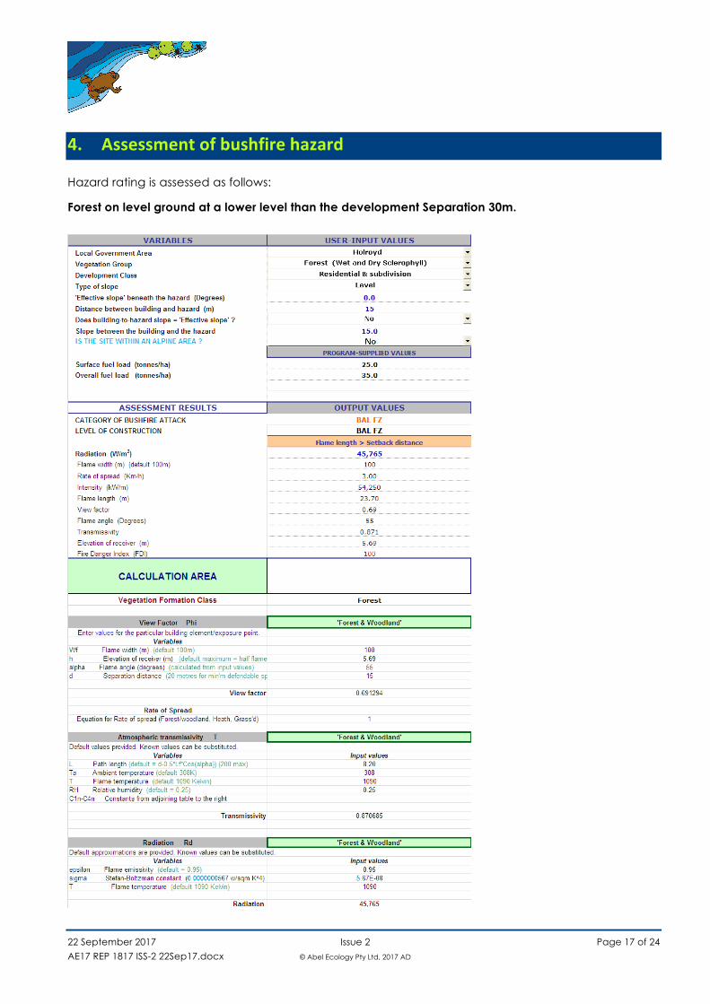
4. Assessmentofbushfirehazard
Hazard rating is assessed as follows:
Forest on level ground at a lower level than the development Separation 30m.
22 September 2017 Issue 2 Page 18 of 24
AE17 REP 1817 ISS-2 22Sep17.docx © Abel Ecology Pty Ltd, 2017 AD
5. Issuesarisingfromtheassessment
5.1 Threat
The facility may be threatened by bushfire in the form of a forest fire (Figure 5). Radiant heat is likely to impinge on built structures. Flame and smoke provide atmospheric conditions
that create a path for electrical discharge. That is the reason that electrical transmission lines and substation switch yards have clearances from vegetation. Even so, dense smoke and flame flares provide a path for earthing from high voltage electrical structures.
A fire poses a heat exposure that increases over about 15 minutes to a peak which lasts for about three minutes. The heat impact then declines by about half each 15 minutes. A smoke plume may
be of longer duration depending on wind direction but is not predictable.
5.2 Protection criteria
The performance criterion is to protect any staff from undue exposure to radiant heat of 10kW/m2.
Any part of the facility will need to withstand a radiant heat of 46kW/m2 for three minutes and 25kW/m2 for 15 minutes, then reducing by half each 15 minutes thereafter.
5.3 Analysis
The location of threats is south and east of the area proposed for development (
Figure 3). The level of exposure is shown in summary in Table 1 below and fully in Section 4.
Any part of the facility within 55m of forest will need to withstand a radiant heat of 46kW/m2 for three minutes. That is, the BS7 air cooled condenser and the BS10 sub station are exposed to bushfire attack. Flame length is modelled at 23.7 metres of solid flame. However intermittent flame does extend
double that length to 47.4 metres so both BS7 and BS10 are at risk of flame contact. In that event significant arcing discharge is likely.
5.4 Management strategies
Clearance of 30m from forest, being that mown turf landscaped batter will be an adequate buffer distance for operational clearance for fire fighting.
22 September 2017 Issue 2 Page 19 of 24
AE17 REP 1817 ISS-2 22Sep17.docx © Abel Ecology Pty Ltd, 2017 AD
Development of buildings adjacent to forest closer than 55m will require Fire Resistance Level construction of FRL 30/30/30 minimum for any wall facing forest. Most commercial construction is higher than that but any windows will need to be screened with stainless steel mesh with a maximum
aperture 2mm. Staff and fire fighters require a retreat from flame and radiant heat which may be in the form of a
door into a building or behind a wing wall. Table 1. Summary of radiant heat exposure.
Location of a development on the site Separation (metres)
Radiant heat kW/m2
Flame length (metres)
Forest on level ground with development on a slope above
30 46 Solid 23.7 Intermittent 47.4
6. Infrastructureandotherrequirements
6.1 Asset Protection Zone management
Legislative responsibility to manage hazardous fuels s.63(2) RF Act
S.63(2) of the Rural Fires Act 1997 No 65 states, “It is the duty of the owner or occupier of land to take the notified steps (if any) and any other practicable steps to prevent the occurrence of bush fires on, and to minimise the danger of the spread of bush fires on or from, that land.”
The occupants will be required to maintain fuel levels consistent with the provisions of the Asset Protection Zone.
6.2 Access and egress
The following roads provide adequate access for fire fighting vehicles and evacuation opportunity for staff.
Public roads
Honeycomb Drive provides access to the property.
Property access
Fire fighting vehicles access for turning, passing bays and operational activities are to suit a Medium Rigid Vehicle.
There is no road access to the rear of the site for operational activities. Specifications for fire engineering for any buildings is expected to fulfil this requirement.
22 September 2017 Issue 2 Page 20 of 24
AE17 REP 1817 ISS-2 22Sep17.docx © Abel Ecology Pty Ltd, 2017 AD
6.3 Availability of fire fighting services
The nearest Fire Station is within 5 km from the site. NSW Fire and Rescue, Huntingwood Drive, Huntingwood (8km).
NSW Rural Fire Service Rooty Hill Road South, Minchinbury (5km). NSW Rural Fire Service, The Horsley Drive, Horsley Park (8km).
6.4 Landscaping
The landscape plan prepared for the site must observe the criteria for Inner Protection Area around the buildings, and is to include fire retardant local species of trees. Landscaping is not to abut buildings as this may cause a direct fire path to combustible building elements.
A pathway or non-combustible ground finish is to adjoin any building for a distance of at least 1.0 metre.
Turf batters are to be mown as lawn.
7. Buildingconstructionrequirements
7.1 Ember attack
Openings in the construction can permit wind-blown embers into buildings and hence cause a fire.
The opening portions of windows and sliding glass doors will need to be protected with corrosion resistant metal gauze screens (e.g. bronze or steel, aluminium is unacceptable due to its low melting point) with a maximum aperture of 2 mm.
7.2 Radiant heat
Radiant heat will increase the temperature of materials. If these materials are combustible, the ember shower can easily ignite the gases given off from the heating process. It is therefore important to
protect or reduce the use of combustible materials.
7.3 Direct flame
In the worst possible fire conditions it is estimated that the flames can last for up to 90 seconds. Suitable building materials will help to ensure that the building and other infrastructure will survive these
conditions. Electrical design for high voltage structures and transmission lines may need to consider protection from discharge into a flame flare.
22 September 2017 Issue 2 Page 21 of 24
AE17 REP 1817 ISS-2 22Sep17.docx © Abel Ecology Pty Ltd, 2017 AD
7.4 Smoke plume
Electrical design for high voltage structures and transmission lines may need to consider protection from discharge into a smoke plume. That may be by insulated lines or underground cables.
8. Conclusionandrecommendations
In our opinion, the site is not sterilised by the bushfire threat. The owners will therefore be able to construct the proposed facility with the following measures included:
d) Building construction for all aspects of the buildings excluding windows will need to be minimum FRL 30/30/30 for structures within 55m of forest;
e) Openable portions of windows within 55m of forest are to be screened with metal mesh maximum
2mm aperture;
f) Water requirements. Fire hose reels must be provided, which is capable of reaching all extremities of the proposed development.
g) Grass turf batters between the facility and forest is to be mown as lawn.
22 September 2017 Issue 2 Page 22 of 24
AE17 REP 1817 ISS-2 22Sep17.docx © Abel Ecology Pty Ltd, 2017 AD
Appendix1. GlossaryofDefinitionsandTerms
This section defines and explains some commonly used expressions relating to bushfires.
Bushfire (or wild fire) is generally defined to mean any unplanned fire in vegetation. Fires can also be used for land management purposes such as grazing or hazard reduction. Bushfires generally have a
seasonal pattern and occur in spring and summer but can occur at other times of year under suitable conditions. The behaviour of fires is primarily influenced by:
• fuel (type, load, moisture, continuity and compaction); • ignition source; • topography (slope and aspect); and • weather (humidity, temperature, wind).
Bushfire danger is a relative measure of weather conditions (temperature, drought indices, humidity and wind speed) describing the likelihood of fire ignition, spread, control difficulty and damage
potential. There is currently an emphasis on prevention and suppression of bushfires to minimise damage to human life and property.
Bushfire hazard is an assessment of the particular combination of available fuel (vegetation), slope and climate/weather pattern relating to a site. This includes leaf litter and ground cover, standing fuel of the shrub and canopy layers and the season of the year. The assessment is usually rated on a scale from ‘low’ (or insignificant) to ‘extreme’ and gives a final indicator of the potential severity of a fire. Bushfire risk means the probability of a wildfire “igniting, spreading and causing damage to assets of value to the community” (Planning for Bushfire Protection 2001). Related to this is bushfire threat which
is the threat of potential damage to life and property arising from a combination of hazard, risk and bushfire danger.
Hazard reduction means a reduction or modification of fuel by burning, chemical, mechanical or manual means.
Prescribed burn means a planned fire ignited by a land manager in accordance with a fuel management plan or for ecosystem management purposes. Fire regime means the pattern of occurrence of fire, specifically the regularity, periodicity, seasonality,
spatial extent, patchiness and intensity. This is important in terms of assessing risks and ecological impacts and is often used in prescribing a management goal to be achieved. There is debate about what constitutes a natural or pre European fire pattern. For the purpose of these definitions natural
means an existence independent of human action.
22 September 2017 Issue 2 Page 23 of 24
AE17 REP 1817 ISS-2 22Sep17.docx © Abel Ecology Pty Ltd, 2017 AD
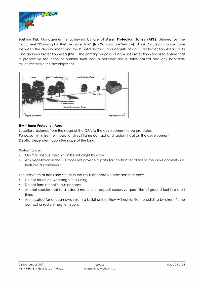
Bushfire Risk Management is achieved by use of Asset Protection Zones (APZ), defined by the document “Planning For Bushfire Protection” (N.S.W. Rural Fire Service). An APZ acts as a buffer zone between the development and the bushfire hazard, and consists of an Outer Protection Area (OPA)
and an Inner Protection Area (IPA). The primary purpose of an Asset Protection Zone is to ensure that a progressive reduction of bushfire fuels occurs between the bushfire hazard and any habitable structures within the development.
IPA = Inner Protection Area Location: extends from the edge of the OPA to the development to be protected Purpose: minimise the impact of direct flame contact and radiant heat on the development Depth: dependent upon the slope of the land
Performance: • Minimal fine fuel which can be set alight by a fire • Any vegetation in the IPA does not provide a path for the transfer of fire to the development - i.e.
fuels are discontinuous. The presence of trees and shrubs in the IPA is acceptable provided that they:
• Do not touch or overhang the building; • Do not form a continuous canopy; • Are not species that retain dead material or deposit excessive quantities of ground fuel in a short
time; • Are located far enough away from a building that they will not ignite the building by direct flame
contact or radiant heat emission.
22 September 2017 Issue 2 Page 24 of 24
AE17 REP 1817 ISS-2 22Sep17.docx © Abel Ecology Pty Ltd, 2017 AD
Appendix2. CompanyProfile
Abel Ecology has been in the flora and fauna consulting business since 1991, starting in the Sydney
Region, and progressively more state wide in New South Wales since 1998, and now also in Victoria. During this time extensive expertise has been gained with regard to Master Planning, Environmental Impact assessments including flora and fauna, bushfire reports, Vegetation Management Plans,
Management of threatened species, Review of Environmental Factors, Species Impact Statements and as Expert Witness in the Land and Environment Court. We have done consultancy work for industrial and commercial developments, golf courses, civil engineering projects, tourist developments
as well as residential and rural projects. This process has also generated many connections with relevant government departments and city councils in NSW. Our team consists of four scientists and two administrative staff, plus casual assistants as required.
Licences
NPWS s132C Scientific licence number is SL100780 expires 30 April 2018. NPWS GIS data licence number is CON95034. DG NSW Dept of Primary Industries Animal Care and Ethics Committee Approval expires 8 November
2017. DG NSW Dept of Primary Industries Animal Research Authority expires 8 November 2017.
The Consultancy Team
Dr Danny Wotherspoon
Grad Dip Bushfire Protection (University of Western Sydney 2012) PhD, researching Cumberland Plain vegetation and fauna habitat, at Centre for Integrated Catchment Management (University of Western Sydney, 2007)
Planning for Bushfire Protection Certificate course (University of Technology, 2006) Consulting Planners Bushfire Training Course (Planning Institute of Australia, 2003) MA (Macquarie University, 1991)
Wildlife Photography Certificate (Sydney Technical College, 1987) Herpetological Techniques Certificate (Sydney Technical College, 1986) Applied Herpetology Certificate (Sydney Technical College, 1980)
Dip Ed (University of New England, 1978) BSc (University of New England - Triple Majors in Zoology, incl. Ecological Zoology, 1974)
Dr Daniel McDonald
BScAgr, MAgr, PhD, MLinSoc NSW, White card, Snr first aid cert, EWP certificate, QTRA, VTA.
Daniel is an experienced ecologist with expertise in fauna, plant species identification, vegetation assessment, agriculture, conservation genetics and seed collection and preservation. He is accredited both for BioBanking assessments and Biodiversity Certification. His present research interest is in Eastern
Suburbs Banksia Scrub and fragmented endangered ecological communities.