burke lakefront airport - greencitybluelake · burke lakefront airport a report on its history, its...
TRANSCRIPT

BKL Burke Lakefront
Airport
A Report on its History, Its Current Status and Its Future
By
William M. Ondrey Gruber Attorney-at-Law
And
Joanne Kaufman
Research Consultant
Prepared for:
The BLUE Project
Building the Livable Urban Edge A partnership of the Cleveland Waterfront Coalition and EcoCity Cleveland.
September 18, 2002

2
Table of Contents Page
Legal Status of Burke Lakefront Airport……………………………………………..……4 Ownership of Burke Lakefront Airport………………………………………………..…..4 The History of Burke Lakefront Airport…………………………………………………..5 Environmental Conditions of Burke Lakefront Airport..………………………………….7 Burke Lakefront Airport Today – General Data…………….…………………………….11 Master Plan for Burke Lakefront Airport – 1999…………………………………………14
Master Plan Recommendations……………………….…………………………...15 Federal Aviation Administration (FAA)……………………….………………………….15 Finances at Burke Lakefront Airport……………………………..………………………..17
Revenues…………………………………………………..……………………….18
Expenses……………………………………………………..……………………..20 Impact of Burke on the Cleveland Economy…………………………..…………………..22 The Future of Burke Lakefront Airport………………………………..…………………..23 Bike Path Around Perimeter……………………………………………………………….27 Interest Groups and Individuals Interested in Burke’s Future……………………………..28 Interviews…………………………………………………………………………………..28
Edward W. Hill, Professor in Urban Studies and Public Administration……..…...28
Thomas P. Slavin, President, Burke Lakefront Services, Inc., dba Million Air…...29
Michael Dolan, Cleveland City Councilman, Ward 21…………………………….31 David Goss, Greater Cleveland Growth Association………………………………31
Conclusions…………………………………………………………………………………32 Contact Information………………………………………………………………………...34

3
Tables Table A - Data of Operations and Landings at Burke Lakefront Airport……………………12 Table B - Monthly Landings Data for Burke Lakefront Airport……………………………..13 Table C - Leases and Concessions by the City for Burke Airport Facilities…………………18 Table D - Burke Airport Revenues – 2001…………………………………………………...20 Table E – Actual and Projected Expenses for Burke Airport – 1998 thru 2002, and 2017…..21 Table F – Burke Deficit Calculation – Expenses By Category & Revenues – 2000 – 2002…22 Table G – Based Aircraft Mix Comparing Burke Airport and Cuyahoga County Airport…..25 (1990) Table H – Operational Fleet Mix Comparing Burke Airport and Cuyahoga County Airport..25 Table I – Based Aircraft Mix Comparing Burke Airport and Cuyahoga County Airport……26 (2001)

4
Legal Status of Burke Lakefront Airport Cleveland City Charter Section 76-8 places the control and operation of “airplane landing fields” of the City in the Department of Port Control. It also states that the Director of Port Control “shall have charge of the administration and control of the…Municipally owned airport facilities of the City…” The Charter states that the Department of Port Control has responsibility for the City’s airports “unless and to the extent that such facilities are conveyed to, or otherwise made available for use by, a port authority originally created jointly by the City and the County of Cuyahoga…” Such a conveyance must be approved by City Council. Only the citizens of the City can change the City Charter. However, the City Charter does not create Burke Airport nor require it to exist. The Codified Ordinances (C.O.) of the City create the Division of Burke Lakefront Airport (Section 139.05 C.O.). The Division of Burke is administered and controlled by a Commissioner of Burke Lakefront Airport, subject to the direction of the Director of Port Control. The Commissioner’s duties are set forth in Section 139.051 of the Codified Ordinances. The Commissioner fixes the charges for hangar space, and landing and take-off fees, subject to the approval of the Board of Control (which is made up of by the Mayor and his/her cabinet.) Ownership of Burke Lakefront Airport Burke is built entirely on fill placed on the Lake bottom. (See maps #s 21 and 22, attached.) The State of Ohio owns the Lake bottom and thus any fill laid upon that bottom. The State has a mechanism for leasing filled-in Lake bottom; through Submerged Lands Leases.1 The City thus can be said to “own” the property on which Burke is located, and has the right for its property to occupy the State’s Lake bottom. The City cannot sell, lease or sub-lease Burke without approval of Council (Sections 183.01 and 183.02 C. O.), and likely needs the approval of the State as well. The City can grant leases by way of concession (Section 183.03 C.O.) to private entities for projects or activities at Burke that the City is authorized to engage in, or concession agreements or contracts for use of City-owned facilities (Section 183.04 C.O.) for offering services to the public. Council must approve such leases and concession agreements (except concession agreements for thirty (30) days or less). Concession agreements for a term of more than one year must be competitively bid (except that Council can waive this by ordinance, and frequently does).
1 The City cannot locate any Submerged Lands Lease for Burke Property, but the Ohio Department of Natural Resources, Division of Real Estate, says that the City has a blanket 50 year Submerged Lands Lease for lakefront properties that it received in 1978 – meaning that it expires in 2028. A copy of the Lease and verification of the inclusion of Burke has been requested. Likewise, a copy of any lease from the State to the Port Authority for Dike 12 at the eastern end of Burke has been requested. There are also references in various places to a deed granted to the City through special legislation by the Ohio General Assembly, giving the City special rights as to lakefront properties, although such a document has not been located, nor any direct evidence of such a grant. For example, in an Application in 1972 by the City to the Army Corps for the construction of a bulkhead at East 40th Street, the City notes: “The area (to be filled on the Lake bottom) is now deeded to the City of Cleveland by the State of Ohio by virtue of several Acts of the State General Assembly.”

5
There is a specific provision of the City Charter that deals with “territory now covered by the waters of Lake Erie within the territorial limits of the City of Cleveland, or formerly covered thereby but now or hereafter filled.” (City Charter Section 45.) This applies to all of Burke. This section states that “Council may submit to the electors…the question of the proposed alienation, surrender or release of any rights of the City of Cleveland” in lakefront lands as described above---which would include Burke Airport. (Emphasis added.) The Charter section goes on to say that “no such proposition shall be required to be submitted to the vote of the electors in the case of granting of leases or franchises in or to said territory or any part thereof or in the event that such territory or any part thereof is conveyed to, or otherwise made available for use by, a port authority originally created jointly by the City and the County of Cuyahoga under authority of the laws of Ohio.” (Emphasis added.) Thus, this Charter Section arguably requires that any sale of Burke or any other filled in lakeshore property of the City (other than leases or franchises, or a transfer to the Port Authority) must be approved by the voters. The History of Burke Lakefront Airport On August 25, 1947, the Cleveland Lakefront Municipal Airport celebrated its official grand opening.2 Cleveland City Manager William R. Hopkins announced the plan for the lakefront airport back on August 7, 1927.3 In an article in November of 1927 by City Manager Hopkins, he set forth the history that led to the City being able to plan for the construction of an airport on the lakefront.4 He wrote that the U.S. government extended the break wall (known then as the “breakwater”) in 1915 to Gordon Park at a cost of $8 million. He also noted that litigation lasting many years finally settled the ownership of the lakefront.5 The Ohio Supreme Court in the case of State of Ohio v. Cleveland Pittsburgh Railroad Co., 94 Ohio St. 61, determined in 1916 that title to all submerged land in Ohio belonged to the State, except the U.S. Government had the right to establish harbor lines6, and riparian (land side) owners have the right to access to the Lake’s waters and to wharf out for navigation. Then in 1925, Ohio passed the Abele Bill, which gave cities the powers of the State as to submerged lands. Cities were given definite powers to plan for the improvement of their lakefront areas, to build structures as needed, and to enter into agreements to assess costs to riparian owners. The City’s Manager noted that the City Administration had, during 1926 and 1927, worked out a general plan of harbor development, in consultation with riparian owners and the Army Corps of Engineers, which he asserted had the almost unanimous consent of all parties concerned. He said that the plan next had to be approved by the City Council after public hearings. The plan included a bulkhead to be built from East 9th Street to East 26th Street 600 feet south of the harbor line, and then onto Gordon Park 650 feet south of the harbor line. (See Photo #1 attached.) A strip of newly filled land would be created 550 feet wide between the bulkhead and the marginal railroad (a total of 203 2 “The Clevelander,” The Lakefront Airport…A Boon to Cleveland Business, Peter B. Petrovich, July 1951. 3 Cleveland, The Making of a City, William Ganson Rose, The World Publishing Company, Cleveland, 1950, at p. 850. 4 “The Clevelander,” Realizing On Our Lake Front, W. R. Hopkins, City Manager of Cleveland, November 1927. 5 The Ohio legislature attempted to settle lakefront ownership disputes with the Fleming Act, passed in 1917, which gave the State full title, and limited shoreowners’ rights to making reasonable use of the waters in front of their land for consumption and to lands gained through natural accretions. No right to fill or wharfing out was recognized. Municipalities were granted some rights to administer public rights to the shoreline. Cleveland, The Making of a City, William Ganson Rose, The World Publishing Company, Cleveland, 1950, at pp. 750-751. When the Lakeland Freeway was built in 1938 from East 9th Street to Gordon Park, owners of property challenged the Fleming Act’s restrictions on their rights, but the Fleming act was upheld by the Court of Appeals in 1946, and later by the Ohio Supreme Court. Id., at p 945. 6 Hopkins reports that the Harbor Line defines the area of open water that must be left between the extreme projection of any structure out from the land and the breakwall. It is established by the Federal government.

6
acres). At that time, the City intended that the filled area would pertain to shipping, with docks all along the bulkhead. However, Mr. Hopkins noted that “(t)he city’s property just east of Twelfth street would furnish an admirable downtown landing place for aircraft and hydroplanes as well as an extremely accessible harbor for small craft.” For a while, the proposed location for land planes was at Edgewater Park on the West Side of the City, and for seaplanes a ramp on the East Side lakefront was favored.7 In 1929, Mayor John D. Marshall announced that the rivers and harbors committee of City Council would hold special hearings on the subject of a downtown airport.8 In 1929, the first Cleveland National Air Show was held. By 1930 Thompson Aeronautical Corporation operated a daily hydroplane passenger service from a small lakefront airport at East 9th Street.9 A ramp for seaplanes was built on the East Side lakefront for the Great Lakes Exposition in 1936 and 1937. (See photo #2 attached.) By 1945, amphibious planes were landing and taking off on Cleveland’s lakefront east of East 9th Street and the Coast Guard Station at an area called the Plane Harbor. (See map #3 attached.) A plan for construction of a bulkhead and placement of fill was approved by City Council on May 11, 1942, as part of the City’s “Official Lake Front Development Plan,” although the actual construction of the bulkhead was not approved for three more years. (Ordinance No. 232-A-42.)10 The City established landing fees for “commercial airline planes” by September 1945. (Board of Control Resolution No. 794-45, adopted September 12, 1945.) Also, in 1945, Cleveland City Council passed a resolution asking that the City Planning Commission conduct a study into the desirability of constructing a downtown lakefront airport. (Resolution No. 1456-44, passed May 21, 1945.) On June 28, 1946, Cleveland Mayor Thomas A. Burke signed legislation that City Council had approved on June 24th, which changed the City’s Lake Front Plan to include creation of “landing places for land and amphibious planes” in the area to be filled from East 9th Street east to East 26th Street, north of the Cleveland Memorial Shoreway. (Ordinance 2705-45, enacting new Codified Section 30-4-A.) The ordinance included a proposed new Harbor Line that had to be approved by the Federal Government. At that time, according to the engineering map accompanying the legislation (see photo map #3 attached), the area east of East 9th Street contained the following: a “government pier,” the Coast Guard station, a “plane harbor,” and existing fill in a relatively narrow strip along the north side of the Shoreway. The map indicates the proposed fill area, which at that time was planned to take much of the shape of the current Burke Airport grounds. The Lakefront Airport was later re-named in honor of Mayor Burke.11 In July 1946, the City’s Division of Design and Construction in the Department of Public Properties, issued a “Cleveland Region Airport Plan,” that included a proposed downtown “port” (see map #4 attached). This Plan states that “(t)he port will cater primarily to amphibious plane operations and will have all the facilities for sea plane or hydroplane operations. In addition the field will have two runways which will effectively handle bi-motor plane operations and permit feeder line service and air taxi service planes for shuttle passenger service to the Cleveland Municipal Airport.”12
7 “The Clevelander,” The Lakefront Airport…A Boon to Cleveland Business, Peter B. Petrovich, July 1951. 8 “The Clevelander,” The Lakefront Airport…A Boon to Cleveland Business, Peter B. Petrovich, July 1951. 9 Cleveland, The Making of a City, William Ganson Rose, The World Publishing Company, Cleveland, 1950, at p. 892. 10 Ordinances Nos. 430-42 and 431-42, passed May 17, 1943, called for the Mayor to control and properly fill the lakefront area in accordance with the City’s Lake Front Plan. 11 The Encyclopedia of Cleveland History, David D. Van Tassel and John J. Grabowski, Indiana University Press, 1987, at p. 138. The Airport was named for Burke on October 10, 1958. 12 Cleveland Region Airport Plan, July 1946, at p. 31.

7
On October 29, 1945, Council finally approved the construction of the bulkhead made of “blast furnace slag” from East 9th Street to Gordon Park. (Ordinance No. 2177-45) The bulkhead was constructed from 1946-1948. (See photos and map #s 5, 6 and 7, attached.) The area behind the bulkhead between East 14 and East 26th Street was approved for filling by dredgings in 1948. (Ordinance No. 1336-48, passed June 14, 1948.) The filling was then begun in 1950.13 By 1947, City Council approved the construction of a “boundary line fence and gate openings” and “a prefabricated building to house the airport control office, comfort station and fire equipment” for the Cleveland Lakefront Airport. (Ordinances Nos. 1682-47, passed July 31, 1947, and 2147-47, passed November 10, 1947, respectively.) The City also had erected a ten unit T-hangar for the storage of aircraft by 1947. (See Ordinance No. 634-53, passed June 28, 1954.) The field occupied a total of 32 acres with a 2,000-foot runway, with work underway by 1951 to add another 123 acres and construct two parallel runways by 1953-1954.14 (See photos #s 8 and 9.) In 1954 City Council approved the issuance of $3.6 million in bonds for the purpose of constructing an airport terminal, runways, and for bulkheading and filling at the Lakefront Airport. (Resolution No. 1844-54, passed June 28, 1954. Filling and grading continued through 1956. (See photo #10, attached.) The first paved runway, 5,200 feet in length, opened in the summer of 1957, enabling the Lakefront Airport to double air traffic to more than 100 planes daily, and creating the need for a control tower.15 (See photos #s 11 and 12, attached.) The Control Tower was constructed in 1961. The east and west concourses were built in 1968.16 Fill was added throughout the 1960s and 1970s, extending the Airport property eastwards. (See the photos and diagrams #s 13-20, attached.) Plans for an Aviation High School on the grounds were prepared in 1973. (See diagrams #s 19 and 20, attached.) Burke had scheduled commercial airline passenger service until 1990. As recently as 1987, Burke had more than 313,000 passengers use the Airport. That went down to 191,000 in 1990.17 Master Plans have been prepared for Burke in 1966, 1981, 1992, and an update in 1999. See below for future plans for Burke. Environmental Conditions of Burke Lakefront Airport In 1987, the Ohio EPA notified the City of Cleveland that it had completed a “preliminary assessment” of the former Cleveland Municipal Dump, located in the City along the shore of Lake Erie from the 13 The extension of the bulkhead was approved by City Council in 1947 and 1948; see Ordinances Nos. 1801-47, passed September 8, 1947, and 169-48, passed March 22, 1948; a contract for the construction of the first extension was approved by the Board of Control in October 1947 (Resolution No. 1275-47). A dredging contract for the airport was approved by Council on September 12, 1949 (Ordinance No. 1647-49), by the Board of Control in November 1949 (Resolution No. 1001-49), and then approved by the U.S. Commerce Department, and re-approved by the Board of Control in January 1950 (Resolution 58-50.). 14 “The Clevelander,” The Lakefront Airport…A Boon to Cleveland Business, Peter B. Petrovich, July 1951. 15 Cleveland Press, Jet-Age Pace Set for City’s Aviation Progress in ’57, January 4, 1957; and The Encyclopedia of Cleveland History, David D. Van Tassel and John J. Grabowski, Indiana University Press, 1987, at p. 138. 16 Burke Lakefront Airport, Master Plan Update, at Landrum and Brown, September 1999. 17 Burke Lakefront Airport: A Critical Link in Greater Cleveland’s Airport System, Department of Port Control, City of Cleveland, February 4, 1991.

8
mouth of the Cuyahoga River to East 55 Street, approximately a 4-mile distance. This area includes part of Burke Lakefront Airport. The “preliminary assessment” was conducted as part of Ohio EPA’s process to identify and remedy hazardous materials problems in Ohio. Ohio EPA was at that time “screening” or doing a preliminary assessment of over 800 sites in the State that were included on the U.S. EPA’s Comprehensive Environmental Response, Compensation and Liability Information System (CERCLIS) list of more than 22,000 sites nationwide. The purpose of the screening was to prioritize sites for additional investigation under the National Contingency Plan (40 CFR Part 300). Particularly bad sites could end up on the Superfund Sites list. The Cleveland Municipal Dump site, including Burke Airport, was on the Federal government’s CERCLIS list. However, the Ohio EPA found that the area of the Dump “poses a low threat for groundwater contamination (‘silts and clays yield little water’) and for surface water contamination (‘previous dumping of debris encroached the Lake Erie shoreline’)” and recommended a low priority for State and Federal activities.18 This meant that the area would not be considered by the U.S. EPA for remedial action. The Ohio EPA concluded that they could not find evidence of any hazardous material ever being disposed of at this location, and that most of the material was construction and demolition debris, mixed with some garbage. They found that the dump closed in the 1940s.19 However, the EPA was incorrect on this latter point, since late into the 1950s a lakefront garbage dump, also used for the burning of garbage, operated north of the East Shoreway, probably at various locations, and definitely between East 26th and East 40th Streets. One photo, undated, states in its caption: “For years, the city’s reach into Lake Erie was aided by a constant succession of trucks and horse-drawn wagons dumping rubbish along the shoreline.”20 The City itself operated a lakefront dump where it burned garbage at the East 26th Street to East 40th Street location until at least 1958. In 1956, Cleveland City Council introduced an ordinance that referred to the anticipation “that upon the closing of the Lakefront Dump” waste haulers would want to use the City’s incinerators. (Ordinance No. 1284-57, introduced May 1957, and reported in the City Record of May 29, 1957; see also Ordinance No. 2251-57, introduced in November 1957, and reported in the City Record of November 27, 1957.) In May 1957, the Cleveland Press showed a panoramic view of ash and smoke blowing over downtown and the East Side of the City coming from the lakefront dump, which the paper captioned “Rain of Filth.” The paper noted that even the panoramic photograph could not “begin to register the inconvenience, disgust, and dismay it caused to Cleveland’s citizens.”21 In June 1957 the newspaper described the “city dump, at Cleveland’s Lake Erie front yard” as “a scene of organized ugliness…As many as 1000 trucks bring their tattered loads of rubbish to the dump each
18 The City sought to have Burke de-listed in 1995, but the OEPA found that the inclusion of 22 acres of Burke where solid waste was deposited for many years, and hazardous material was found in the City’s environmental study, was appropriate. Letter from OEPA to Mayor Michael R. White, City of Cleveland, April 11, 1995. 19 It should be noted that the OEPA’s conclusion was based on anecdotal evidence provided verbally by Bob Moore of the County Health Department, Sylvia Corteze of the City Health Department, and Joseph Stamps, City Service Director. The Ohio EPA Letter was signed by Charles M. Taylor, Chief, Division of Solid & Hazardous Waste Management, and sent to George V. Voinovich, Mayor, dated August 11, 1987. The Preliminary Assessment, Cleveland Municipal Dump, Site Number OHD 980-509-772, was submitted by Grant Wilk, DSHWM, NEDO, and reviewed by Rodney Beals, DSHWM, NEDO, and is dated August 13, 1987. (Note: “DSHWM” is the Division of Solid and Hazardous Waste Management, and “NEDO” is the North East District Office of Ohio EPA.) 20 Cleveland Press Collection of the Cleveland State University Archives. 21 Plans to Speed New Incinerator Hit Snag, Cleveland Press, May 1, 1957, p. 37.

9
day. Fires are set several times a week…End of the lakefront eyesore is at least 18 months away when the West Side incinerator is completed.”22 The Cuyahoga County Court of Appeals issued an order on October 17, 1957, declaring the City’s lakefront dump a public nuisance, and ordering that the fires end by January 1, 1958. The Court stated: “Because dump burning has gone on for 50 years…‘has no significance in view of the overwhelming evidence that such method of disposing of combustibles is archaic, outmoded and unnecessary.’”23 The case was a taxpayer’s suit brought in 1955 by Attorney Charles R. Miller, on behalf of John Neubauer, of East 36th Street, an officer of the Goodrich Area Council.24 The City continued using the lakefront site as a garbage dump even after it ended the burning of garbage. Rules and Regulations for the operation of the Cleveland Lakefront Dump between East 26th and East 40th Streets were published in the City Record on January 8, 1958. The Dump barred paints, magnesium, varnishes, lacquer, paint thinners, oil, or any other volatile or highly combustible material. An affidavit of a former City employee responsible for all Burke operations during his 8 hour a day shift, Anthony Starr, asserts that when he began his employment in early 1955 Burke had recently been expanded by infilling with dredge materials from East 14th Street to East 26th Street. Directly east of this area, there was an ongoing process of infilling with garbage from residential pickups by the City. He states that commercial waste was not permitted during his time with the City, but that is contradicted by Cleveland Press reports that commercial dumping was banned only in 1957-1958. He states that the City stopped infilling with garbage in 1957-1958, and that after that only building materials such as cement, concrete, brick, masonry, sand, and earth were used for filling purposes between East 26th and East 40th Streets north of the Shoreway.25 Articles from the time indicate that the City was allowed by the Court of Appeals to bury wastes on the lakefront site, but not burn them, after January 1, 1958.26 Yet articles also indicated that the burying of garbage at the lakefront dump would only last 3-6 months into 1958 at most.27 However, due to the Court Appeals order allowing only 60 days of land filling garbage at the lakefront dump, after March 2, 1958, it is believed that the practice of receiving combustible materials at the lakefront for fill material ceased.28 Investigations by the City have concluded that “after the City ceased burning at the lakefront and accepting combustible wastes in early 1958, the only materials taken in for filling, other than dredge materials, were demolition materials used to fill in the remainder of land between East 26th and East 40th Street.”29 Runway grading materials placed on the dredge fill in 1957 appear to have been fill dirt from the construction of the Cleveland Press Building at East 9th Street and Lakeside Avenue.30
22 Cleveland’s Front Yard – The City Dump, Cleveland Press, June 11, 1957, p. 17. 23 City Loses Appeal on Lakefront Dump, Must End Fires by First of Year, Court Orders, Cleveland Press, October 17, 1957, p. 1. 24 Urges Landfill to End Burning on Lakefront, Cleveland Press, July 9, 1957, p. 4. 25 Affidavit of Anthony Starr, February 3, 1993, City of Cleveland Employee from February 1, 1955 until February 1, 1982. 26 Voters’ Incinerator Demands Mustn’t Be Overlooked, Cleveland Press, December 26, 1957. 27 Court OK’s City Plan to Bury Trash, ?, 1957. 28 Letter of Theodore J. Esborn, Attorney at Law, to William Skowronski, Ohio EPA, dated February 26, 1993. Mr. Esborn was hired by the City of Cleveland to represent the City in dealings with Ohio EPA on the issue of whether OEPA would grant the City a blanket authorization for operations digging in or moving the soils at Burke. State law requires permission from the OEPA director before any digging in or moving materials located in a former solid waste landfill. Ohio Administrative Code (OAC) 3745-27-13. 29 Id. 30 Id., citing Cleveland Press articles entitled Freeway Ditch Cuts Through Runway Site, March 28, 1957, and Press Building Dirt Goes to Airport, April 22, 1957.

10
The remainder of Burke, a large portion of its land area, was created with dredge fill material from the Cuyahoga River and harbor. Only about 22 acres within Burke Airport contains solid waste. 31 The City’s concern in the 1960s turned toward the water pollution problem in the Lake. In 1969 Council adopted a Resolution urging that the private companies performing dock dredging and the U.S. Army Corps of Engineers “reach an agreement as soon as possible as to the proper disposal of dredged materials so as to prohibit any further pollution of the waters surrounding our community.” (Resolution No. 535-69, passed May 5, 1969.) The Council noted that the City should take up the Army Corps’ offer to dispose of the dredgings in a Federal dike on the lakefront. In 1972, Council authorized the Director of Port Control to accept a permit from the Army Corps to extend the eastern portion of Burke Airport by constructing bulkheading around a lagoon at East 40th Street and fill shoreward from it. (Ordinance No. 653-71, passed March 20, 1972.) The Permit was issued June 13, 1972. In 1992, the City hired an environmental consulting firm, Metcalf and Eddy, to perform a risk assessment of Burke. They took soil samples. The City’s expert concluded, that “(b)ased on the lifetime cancer risks expressed in U.S. EPA’s National Contingency Plan and Ohio EPA’s, “How Clean is Clean Policy,” the risk assessments for all of the receptor populations evaluated at Burke Airport were within acceptable limits with the exception of potential long-term exposure for outdoor maintenance/lawn care workers.”32 On July 8, 1992, OEPA informed the City that they concurred with the conclusion of the risk assessment. OEPA also concluded that the assessment had been performed using very conservative estimates and assumptions. Tests also have shown no detectable level of methane, and there are no areas producing any visible leachate.33 The only risk found by Metcalf and Eddy was that of non-carcinogenic effects for field workers at the airport who were employed more than 25 years on a 140 days per year exposure basis. The explanation for the chemical compounds found in the risk assessment in an otherwise clean area of dredge-fill material, is believed to be the ash from the garbage dump fires to the east of the dredge fill in 1957. The chemical compounds found were the result of incomplete combustion.34 In May 1992, the City Requested permission to perform excavations at Burke Airport for normal operational reasons, pursuant to OAC Section 3745-27-13, after being notified by OEPA that it considered Burke subject to that Rule because Burke was built on a closed solid waste disposal facility. OEPA said that it was willing to grant a blanket exemption with a number of conditions and requirements. 35 OEPA required, among other things, that the City remove all solid and hazardous waste from all excavations. The City requested an exemption from those requirements. 36 In April 1993, the OEPA granted a blanket authorization for excavations at Burke, again with certain conditions.37 The scaled-back requirements involved proper disposal of any solid or hazardous waste 31 Letter from OEPA to Mayor Michael R. White, City of Cleveland, dated April 11, 1995. 32 Letter from David S. Hoffmann, Attorney at Law, on behalf of the City of Cleveland to Donald R. Schregardus, Director, OEPA, September 1, 1992. See also, letter of Bruce W. Kranz, Associate, Metcalf and Eddy, Inc., to Cynthia Rich, Director of Port Control, City of Cleveland, dated June 2, 1992. 33 Id. 34 Letter of Theodore J. Esborn, Attorney at Law, to William Skowronski, Ohio EPA, dated February 26, 1993. 35 Letter from Harry M. Courtwright, Environmental Supervisor, and John R. Watkins, Group Leader, OPEA, to Robert O. Bucklew, Assistant Director of Law, dated May 5, 1992. 36 Letter from David S. Hoffmann, Attorney at Law, on behalf of the City of Cleveland to Donald R. Schregardus, Director, OEPA, September 1, 1992. 37 Letter from Donald Schregardus, Director, OEPA, to Cynthia Rich, Director, Department of Port Control, City of Cleveland, dated April 6, 1993.
11
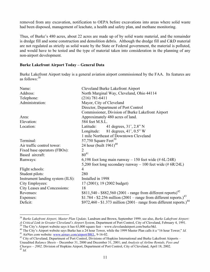
removed from any excavation, notification to OEPA before excavations into areas where solid waste had been disposed, management of leachate, a health and safety plan, and methane monitoring. Thus, of Burke’s 480 acres, about 22 acres are made up of by solid waste material, and the remainder is dredge fill and some construction and demolition debris. Although the dredge fill and C&D material are not regulated as strictly as solid waste by the State or Federal government, the material is polluted, and would have to be tested and the type of material taken into consideration in the planning of any non-airport development. Burke Lakefront Airport Today – General Data Burke Lakefront Airport today is a general aviation airport commissioned by the FAA. Its features are as follows:38 Name: Cleveland Burke Lakefront Airport Address: North Marginal Way, Cleveland, Ohio 44114 Telephone: (216) 781-6411 Administration: Mayor, City of Cleveland Director, Department of Port Control Commissioner, Division of Burke Lakefront Airport Area: Approximately 480 acres of land. Elevation: 584 feet M.S.L. Location: Latitude: 41 degrees, 31’, 2.8” N Longitude: 81 degrees, 41’, 0.5” W 1 mile Northeast of Downtown Cleveland Terminal: 57,750 Square Feet39 Air traffic control tower: 24 hour (built 1961)40 Fixed base operators (FBOs): 2 Based aircraft: 8041 Runways: 6,198 foot long main runway – 150 feet wide (# 6L/24R) 5,200 foot long secondary runway – 100 feet wide (# 6R/24L) Flight schools: 4 Student pilots: 280 Instrument landing system (ILS): Installed in 1998 City Employees: 17 (2001); 19 (2002 budget) City Leases and Concessions: 18 Revenues: $811,540 - $882,560 (2001 - range from different reports)42 Expenses: $1.784 - $2.256 million (2001 – range from different reports.)43 Deficit: $972,460 - $1.373 million (2001– range from different reports.)44
38 Burke Lakefront Airport, Master Plan Update, Landrum and Brown, September 1999; see also, Burke Lakefront Airport: A Critical Link in Greater Cleveland’s Airport System, Department of Port Control, City of Cleveland, February 4, 1991. 39 The City’s Airport website says it has 63,000 square feet – www.clevelandairport.com/burke/bkl. 40 The City’s Airport website says Burke has a 24 hour Tower, while the 1999 Master Plan calls it a “16 hour Tower;” Id. 41 AirNav.com website: www.airnav.com/airport/BKL, 9-16-02. 42 City of Cleveland, Department of Port Control, Divisions of Hopkins International and Burke Lakefront Airports – Unaudited Balance Sheets – December 31, 2000 and December 31, 2001; and Analysis of Airline Rentals, Fees and Charges – 2002, Division of Hopkins Airport, Department of Port Control, City of Cleveland, April 18, 2002. 43 Id.
12
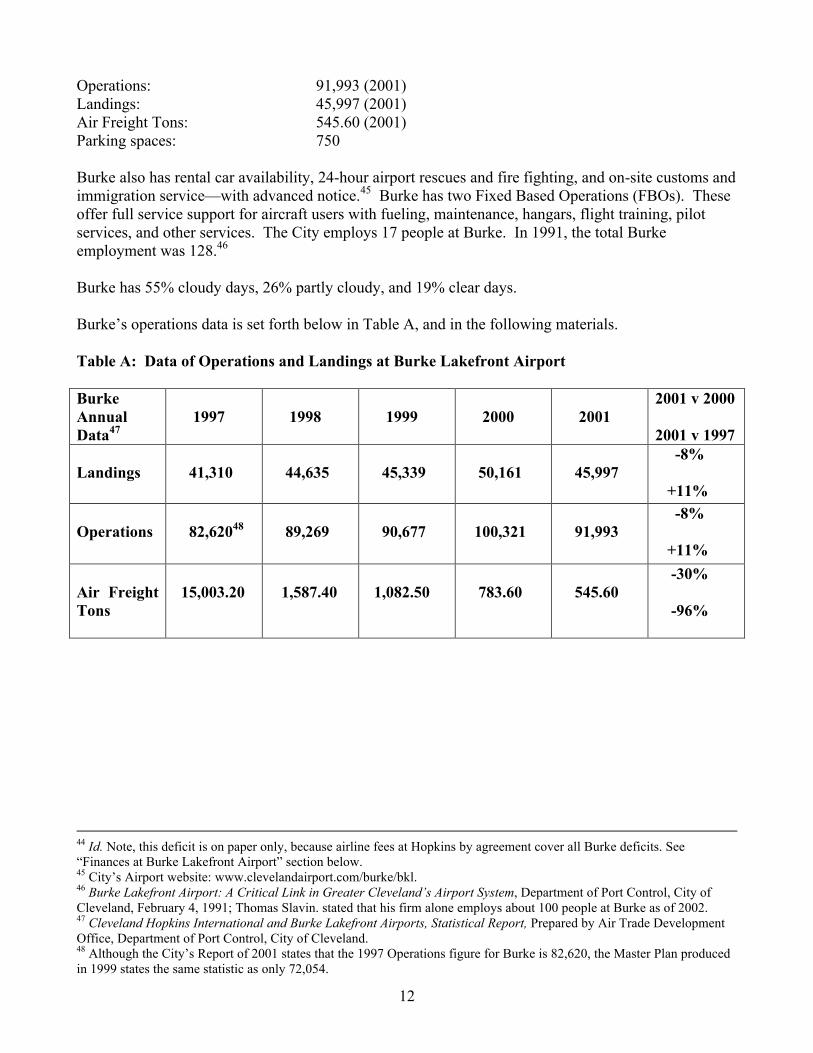
Operations: 91,993 (2001) Landings: 45,997 (2001) Air Freight Tons: 545.60 (2001) Parking spaces: 750 Burke also has rental car availability, 24-hour airport rescues and fire fighting, and on-site customs and immigration service—with advanced notice.45 Burke has two Fixed Based Operations (FBOs). These offer full service support for aircraft users with fueling, maintenance, hangars, flight training, pilot services, and other services. The City employs 17 people at Burke. In 1991, the total Burke employment was 128.46 Burke has 55% cloudy days, 26% partly cloudy, and 19% clear days. Burke’s operations data is set forth below in Table A, and in the following materials. Table A: Data of Operations and Landings at Burke Lakefront Airport Burke Annual Data47
1997
1998
1999
2000
2001
2001 v 2000 2001 v 1997
Landings
41,310
44,635
45,339
50,161
45,997
-8% +11%
Operations
82,62048
89,269
90,677
100,321
91,993
-8% +11%
Air Freight Tons
15,003.20
1,587.40
1,082.50
783.60
545.60
-30% -96%
44 Id. Note, this deficit is on paper only, because airline fees at Hopkins by agreement cover all Burke deficits. See “Finances at Burke Lakefront Airport” section below. 45 City’s Airport website: www.clevelandairport.com/burke/bkl. 46 Burke Lakefront Airport: A Critical Link in Greater Cleveland’s Airport System, Department of Port Control, City of Cleveland, February 4, 1991; Thomas Slavin. stated that his firm alone employs about 100 people at Burke as of 2002. 47 Cleveland Hopkins International and Burke Lakefront Airports, Statistical Report, Prepared by Air Trade Development Office, Department of Port Control, City of Cleveland. 48 Although the City’s Report of 2001 states that the 1997 Operations figure for Burke is 82,620, the Master Plan produced in 1999 states the same statistic as only 72,054.

13
Breakdown of Operations Data – 2001 - By Type of Operation49 (rounded to nearest thousand) Air taxi – 11,000 Jets - 8,000 Helicopter - 17,000 Military - 1,000 Based aircraft and touch and go’s – 34,000 Itinerant - 21,000 Total = 92,000 Burke averages about 275 operations a day: 51 transient, 39 local, 9 air taxi, and less than 1 military and commercial.50 Table B: Monthly Landings Data for Burke Lakefront Airport51 Monthly Landings
1997
1998
1999
2000
2001
November
3,170
4,255
December
2,678
2,934
3,879
2,653
3,085
Hopkins landings and operations did decrease in 2001 compared to 2000, while Burke’s numbers improved. The decline at Hopkins is not steady, with an increase in 1999 compared to 1998, and little change in 1998 compared to 1997. The Master Plan for Burke updated in 1999, noted that a 15% increase in the first 6 months of 1998 over 1997 in the number of operations was attributable mainly to corporate aircraft, which mirrored national trends.52 Corporate aircraft purchases were at an all time high in 1997 and 1998. Even so, the Master Plan projected that future activity at Burke would increase from 72,054 operations to more than 132,000 by 2017. The 11% increase in operations from 1997 to 2001 is close to the projection in the Master Plan; if such a rate continued through 2017, the number of operations would increase to about 128,000 by 2017. The number of based aircraft at Burke was at 70 in 1997, and has increased to 80 today.53 The Master Plan projected the number at 98 by 2017. Thus, the number of aircraft is well ahead of the projection in the Master Plan. Of the 80 aircraft, 52 are single engine, 13 are multi engine, 4 are jet, and 11 are helicopter.
49 Data from Division of Burke Airport Commissioner, Khalid Bahhur, August 2002. 50 AirNav.com, www.airnav.com/airport/BKL, 9/16/02. 51 Cleveland Hopkins International and Burke Lakefront Airports, Statistical Report, Prepared by Air Trade Development Office, Department of Port Control, City of Cleveland. 52 Burke Lakefront Airport, Master Plan Update, Landrum and Brown, September 1999. 53 Id., and Data from Division of Burke Airport Commissioner, Khalid Bahhur, August 2002.
14
Master Plan for Burke Lakefront Airport - 199954 The Master Plan completed for Burke in 1999 was called an “Update,” referring to the Master Plan prepared in 1992, which was never submitted to the FAA for review. The previous Master Plan was completed in 1981. A Master Plan is a long-range plan based on projected demand. It was paid for by a grant from the FAA under Section 505, of the Airport and Airway Safety and Capacity Expansion Act of 1987. The Master Plan assumes that Burke remains a general aviation airport, with no scheduled commercial air service, although the projections and recommendations in the Plan do not preclude commercial air service. General aviation includes all flying activities except commercial airlines and the military. More specifically, it includes corporate, pleasure, news, police, helicopter, training, charter and taxi services. The Master Plan reports that Burke operations include capacity for simultaneous operations on parallel runways for small aircraft in good weather. There is currently not enough space between runways for larger aircraft for simultaneous operations. Air space obstructions have been removed, and noise abatement requirements mean that aircraft must be routed over the Lake. The airport has adequate taxiways, and no capacity limitations. Currently Burke’s operations capacity is 222,000 annually (it had about 92,000 operations in 2001). It has sufficient capacity until at least 2017, when it is projected to reach the 60% of capacity planning threshold. The changes recommended in the Master Plan would allow for 160,000 to 355,000 operations annually. The terminal is in excellent condition, and meets the Airport’s needs. The Master Plan warns, however, that the City should not allow developments, such as non-aviation activities, within the terminal that would preclude commercial air service in the future. The Mater Plan reports the following trends at Burke (as of 1999):
• general aviation increases above the national average • student pilot certifications and the number of pilots increasing • Million Air planning to expand • Business Aircraft Center may expand • Medivac activity increasing • Flights from the Middle East and Canada increasing • Development of the waterfront and downtown increases Burke’s value as an airport • Celebrities, professionals, dignitaries, and executives using the airport more • Sports teams using the Airport • Traffic ingress and egress from parking is a problem
The Master Plan reports that the capacity of the Airport is not negatively affected by winds, and that weather generally has only a minor impact on the capacity of Burke to handle aircraft. High wind conditions occur about 8% of the time. The lack of precision landing instrumentation (ILS) was the reason that Burke had to close an estimated 20 days per year due to bad weather. The new ILS was installed at Burke in 1998.
54 All information in this section is from the Burke Lakefront Airport, Master Plan Update, Landrum and Brown, September 1999, unless otherwise indicated.

15
Master Plan Recommendations The Master Plan recommends the following:
• Adding 40 T hangar units, FBO hangars, and single tenant corporate hangars; • Adding an “outboard” parallel runway by 2017 on the northern side of Burke, on Dikes 10B
and 12,55 to replace the existing “inboard” runway (6R-24L), which would (a) create more room at the southern side of Burke for further development, (b) move the landing approaches and noise further from downtown and east side neighborhoods, (c) enhance safety by providing full size and clear Runway Safety Areas (RSA) and “Object Free Areas” (OFA), and (d) allow larger aircraft to make simultaneous landings and takeoffs;
• Adding 8,608 square yards of paved apron to accommodate general aviation transient aircraft tie downs;
• Adding 62 parking spaces for general aviation use; • Raising fees for the car race and banner fees, and the sharing of costs for North Coast
developments on the southwest side of Burke. The cost of the improvements is estimated to be about $55 million, with the Federal share of 90% covering about $33.8 million, and the State’s 5% funding covering about $3.1 million. The private share that is not eligible for a Federal share would be about $17.6 million, leaving the local share to be about $749,000. The local share might be paid for through General Obligation (GO) bonds, General Airport Revenue Bonds at Hopkins, or Passenger Facility Charges at Hopkins. The City could help subsidize the private share as well. Federal Aviation Administration (FAA) The FAA today has at least one recent grant agreement with the City for Burke Airport improvements, and a lease for the Air Traffic Control Tower Building as follows: Lease (City Contract No. 55779) – City (Lessor) and FAA (Lessee)
Space: 3,391 square feet in Air Traffic Control Tower Building Executed: December 22, 1999 Term: through September 30, 2009 Rent: $31,180.16 annually; $2,598.35 per month (utilities paid by City) Cancellation: Lease may be cancelled by FAA with 30 days notice. There is no provision for
the City to cancel the lease. One of the first dealings with the Federal aviation authorities was in 1950, when the City applied for and was awarded a grant of funds for a dredging and filling project by the Civil Aeronautics Administration (CAA), in the U.S. Department of Commerce. (Ordinance No. 94-50, passed January 9, 1950, accepting the grant). The grant was awarded pursuant to the provisions of the Federal Airport Act (60 Stat. 170; Public Law 377, 79th Congress). The 50% share of the dredging project was funded up to a maximum amount of $100,000. It was known as FAA Project 9-33-029-001. A second grant of
55 The existing Dike 12 former Confined Disposal Facility (CDF) built by the Army Corps is at the far northeast end of Burke, and is currently within the possession and management of the Cleveland-Cuyahoga County Port Authority; Dike 10B is an active CDF being operated at the north central side of Burke. The City of Cleveland is the Local Cooperating Agency for Dike 10B and will therefore assume possession and maintenance responsibility when the Dike is full and closed by the Army Corps (originally projected to be around the year 2014.)
16
up to $225,000 was authorized by Ordinance No. 148-51, passed February 5, 1951 for FAA Project 9-33-029-002, for additional fill and construction of a dike. (This amount was increased to $245,000 in 1952; Resolution No. 633-52, passed May 14, 1952.) A Resolution in 1952 by City Council indicated that the Federal government was about to accept proposals for the matching of funds for airport construction and improvement, and Council wanted to take advantage of the funding by having the City prepare a plan and estimates of the costs of building a “modern lakefront airport.” (Resolution No. 2143-52, introduced November 1952.) The only grant specifically for Burke from the FAA in the period 1997 to July 2002, was a June 26, 1998 grant of $1,496,180, for rehabilitation of the 6,200-foot runway (#6L/24R). The FAA agreed to pay 90% of the cost.56 The grant agreement itself contains no requirement that it be repaid if the airport is no longer used for airport purposes, but the agreement does make reference to requirements under Section 509 (d) of the Airport and Airway Improvement Act of 1982, as amended (49 USC). Title 49 of the laws of the United States (49 USC) establishes certain project grant assurances that airport operators commit to when receiving any grants for improvements. (49 USC 47107) These include the assurance that the airport be available for public use, that the airport will be operated and maintained suitably, that the owner will maintain the approved current layout plan for the airport, and that the owner will not allow any alteration at the airport that does not comply with the approved plan. (49 USC 47107 (a) (1), (7), (16), and (d).) The City states that FAA has made it clear that Burke plays an integral function in the Cleveland Airport System. The City also asserts that the grants from the FAA legally bind the City for 20 years from the date of the last distribution of funds to the City under the grant to conform to certain assurances that stipulate that the City will not “cause or permit any activity or action thereon which would interfere with its use for airport purposes.”57 Even more critical to this consideration, is the City’s assertion as follows: If the City does not meet its obligations under these grants, the FAA can legally demand the
return of these grant monies. If Burke’s aeronautical capabilities are diminished or eliminated entirely, grants to Hopkins could also be threatened. The grant assurances apply to both airports, and the FAA can demand repayment of previous grants from Hopkins and Burke if such capabilities are diminished during the 20-year period.58
FAA has been quoted stating that if the City wanted Burke closed, the FAA would first have to study the effect on regional air traffic. Then the FAA would require that the City repay about $5 million in grants. FAA also asserts that it might even be able to require the City to build a replacement airport or help pay for the expansion of other airports to handle the aircraft that had used Burke.59
56 On July 11, 2002, a public records request for any grant agreements from 1997 to the present for Burke was sent to the Director of Port Control. The 1998 grant was the only one in the last 5 years. In 1991, the City reported that the most recent grant it received was in 1982; Burke Lakefront Airport: A Critical Link in Greater Cleveland’s Airport System, Department of Port Control, City of Cleveland, February 4, 1991. 57 Burke Lakefront Airport: A Critical Link in Greater Cleveland’s Airport System, Department of Port Control, City of Cleveland, February 4, 1991. 58 Id. These statements have not been independently verified. 59 Breaking up Burke may be hard to do, Cleveland Plain Dealer, May 7, 2002, at p. A1 and A8.

17
In the early 1980s, the FAA established guidelines for reliever airports.60 A reliever airport is one that provides an alternative for general aviation aircraft that might otherwise be based or operate at a busy commercial service airport. They serve both local airport activity and transient demand. The FAA established its criteria for reliever airports as part of the National Plan of Integrated Airport Systems (NPIAS). An existing or proposed airport may be designated as a reliever airport if it relieves airport congestion in a metropolitan area by providing general aviation users with an attractive alternative or if it provides increased overall access to the general aviation system. The reliever airport should provide substantial capacity or instrument training relief, as evidenced by at least 50 based aircraft or 25,000 annual itinerant or 35,000 annual local operations, or the installation of a precision instrument landing system when the FAA determines that the airport is a desirable location for instrument activity. Finances at Burke Lakefront Airport Burke and Hopkins Airports are, for financial, budgeting and reporting purposes, combined together. Actually, Burke expenses and revenues are line items in what is basically financial budgeting and reporting for Hopkins. That is because all Burke maintenance, operation and administrative expenses, and all rentals, charges, landing fees, use charges and concession revenues, are included in the calculation of airline rates and charges for Hopkins Airport. Any deficit at Burke is covered by revenues from Hopkins. Thus, Burke losses are offset by Hopkins “surpluses.” The Burke Master Plan states that this situation, where there are two airports in a community with the main commercial airport subsidizing the reliever airport, is “typical.” 61 The Use Agreements with the airlines using Hopkins Airport, which currently expire in 2005, include a provision that the annual deficit at Burke is included in the residual cost formula for Hopkins, up to a limited amount (i.e. a specified maximum.)62 This amount is called the “Allowable Burke Lakefront Deficit.” The airlines agree to have their fees cover the Burke deficits so long as the projected deficit does not exceed the Burke deficit for 2001. The formula is as follows: 2001 Burke deficit, minus the debt service on General Obligation (GO) Bonds for Burke improvements, multiplied by the Consumer Price Index (CPI) for the most recent month, divided by the CPI for the same month in 1975. See Table A, below. The City’s Airports are operated as what is called an Enterprise Fund. That means that the Airports are required to be self-sufficient, and are not supposed to be either subsidized by the General Fund, nor are they to subsidize the General Fund. There is no explicit City Charter provision requiring that the Airports be operated in this manner, as there is for the City’s utilities—water, electric and sewer.63 There is a provision in at least one grant agreement between the City as grantee (or sponsor) and the FAA as grantor, dated June 13, 1995, that appears to be a general agreement whose language may apply to other grants that make reference to the general terms, which states that the City agrees that: …all net revenues produced from real property purchased in part with Federal funds in this grant shall be used on the airport for airport planning, development, or operating 60 Cleveland Airport Reliever Study, Northeast Ohio Areawide Coordinating Agency (NOACA), April 1992. 61 Burke Lakefront Airport, Master Plan Update, Landrum and Brown, September 1999, at p. 4-2. 62 Analysis of Airline Rentals, Fees and Charges – 2002, Division of Hopkins Airport, Department of Port Control, City of Cleveland, April 18, 2002. 63 Additional legal research would be needed to verify the legal basis for the Airport being operated on the basis of an Enterprise Fund, and further research with the Department of Finance would be necessary to confirm that the Airport is actually operated on such a basis.

18
expenses…airport fiscal and accounting records shall clearly identify actual sources and uses of these funds.
Thus, through agreement the City is restricted in how funds and revenue may be used. Revenues: Burke’s revenue sources are from concession and lease agreements, rentals, landing fees and other sources such as the Air Show and the auto race. The current lessees and concessionaires are as follows: Table C: Leases and Concessions by the City for Burke Airport Facilities: 64 Lessee/Concessionaire Term Space Rental 1. Weather Forecast, Inc. 1981-1984 152 sq. ft. office $2,310.75 (#32043) 142.5 sq. ft. counter per year
61 sq. ft. storage ($6.50/sq ft.) 2. Cleveland Police, Employee Assistance Unit none 559.22 sq. ft. office none 3. Dept. of Public Safety, Div. of Police Aviation Unit ? 666 sq. ft. inkind65 4. Dept. of Parks, Recreation 1986-indefinite 4,164.54 sq. ft. $45,809.94 and Properties, Div. of 1ST floor offices per year Research Planning ($11/sq. ft.) and Development (#36978) 5. Dept. of Parks, Recreation 1987-indefinite 9,978.59 sq. ft. $99,785.90 and Properties, Div. of 2nd floor offices per year Research Planning ($10/sq. ft.) and Development (#38338) 6. Circadian Knight Corp. 11/00-11/02 205.34 sq. ft. $2,464.08/yr. dba Top Gun (flight training) ($12/sq. ft.) (# 57061) 7. C.K. Newcomb 5/4/01-5/4/03 1,048 sq. ft. office $12,576/yr ($12) and Associates (#57836) 767 sq, ft. storage $6,136/yr. ($8) 64 Provided by Dept. of Port Control in response to public records request to Port Control of July 11, 2002, which asked for all leases currently in effect. The website AirNav.com lists other Burke services as North Coast Aircraft Radio, Inc., North Coast Flyers, and Precision Helicopter Services, which either do not have leases or the leases were not provided as requested. 65 The Aviation Unit provides security and ticketing services in lieu of rent payments. Value of Unit services calculated at $109,500. Value of annual rent $7,992.

19
8. American Flyers, Inc. (flight training.) 5/29/01-5/29/03 1,711.71 sq. ft. $20,540.52/yr (#57983) ($12/sq. ft.) 9. Airsports Aviation, LTD 6/22/02-6/22/03 826 sq. ft. office $9,912/yr/ ($12) (#59605) 857 sq. ft. store $10,284/yr. ($12) 10. T&G Flying Club, Inc. (flight training) 7/6/01-7/6/03 486 sq. ft. $5,832/yr. ($12) (#58164) 11. Cleveland National 2000-2004 Airport/ Costs of services Air Show, Inc. (#50547) 481.58 sq. ft. office $37,834.78 (2000) (cancelable Rent: $19,000/yr.
w/12 months notice) Rent office: $5,778.96/yr. ($12) 12. Cleveland National Air 1996-2006 (approx.) 8,000-10,000 sq. ft. in-kind Show Foundation; (approx.) Aircraft display (#50071) 13. APCOA, Inc. 9/1/95-see Lease 650 spaces $24,000/yr + (#48824) #48042 50% parking revenues in excess of $75,000/yr. 14. International Women’s 6/1/98-5/31/05 1,000 sq. ft. office $8,139.94/yr. ($8.50) Air and Space Museum, Inc. 552 sq. ft. exhibit + % of gross revenues from (#52903) gift cart 15. Business Aircraft Center 5/16/01-5/16/02? 1,552 sq. ft. $18,624/yr. ($12) (#?) + $.05/gallon fuel/
& $.15/gallon lubricants sold by Business Center
16. The Airplane Company 1982-2012 14,000 sq. ft. + 4% gross revenues/yr. or Hangars, Inc. (#32625) (option to renew thru $14,775/yr minimum +
2022) $.05/$.15/gallon fuel/lubricants
(minimum increases beyond 20th year and thereafter)
17. Burke Lakefront Services,1993-2013 8.205 acres 4% gross revenues/yr. or Inc. dba Million Air $50,000/yr. minimum+ (#46872) (see Airplane above)

20
18. Pufferbelly LTD. 1991-2021 12,881 sq. ft. $20,000/yr. min. or Restaurant (#44237) 2.75%/5% revenues from
food/alcoholic beverages __________________________________________________________________________________ Total Minimum Rental: $375,969.09 + % of revenues and/or sales66 The amount of revenue from lessees and concessionaires provided above is much greater than the amount of concession revenue stated in the City’s Balance Sheets for 2001, which is $300,235.67 It is possible that the City’s Balance Sheets reports these agreements separately, some as concessions and some as “rentals.” In any case, Burke’s revenues are reported in Table D, below, along with the revenue projections from the most recent Burke Airport Master Plan completed in 1999 for comparison: Table D - Burke Airport Revenues - 2001 Source Balance Sheets68 Master Plan Projection69 Concessions $300,235 $292,000 Rentals $196,000 $131,000 Landing Fees $178,530 $158,000 Other $136,129 $147,000 Parking/Ground Transport (APCOA)70
Not specified $214,000
Total: $811,540 $942,000 Actual revenues are thus ahead of the revenue projections in the Burke Master Plan, if the APCOA amount is not included. Also, the actual revenues are ahead of the projections in each category, except for “Other,” which includes the Air Show and auto race. Expenses: Expenses include operating and maintenance expenses, and debt service for revenue bonds issued for Burke improvements. Expenses are reported in the Mayor’s Budget Estimate for 2002, and in a report entitled “Analysis of Airline Rentals, Fees and Charges – 2002,” for the Department of Port Control, Divisions of Hopkins International and Burke Lakefront Airports, issued April 18, 2002. The Master Plan also reported and projected expenses for Burke.
66 Another $37,834.78 was paid to the City in 2000 by the Air Show to reimburse the City for services provided by divisions other than Burke Airport. 67 City of Clevlenad, Department of Port Control, Divisions of Hopkins International and Burke Lakefront Airports – Unaudited Balance Sheets – December 31, 2001. 68 Id. 69 Burke Lakefront Airport, Master Plan Update, Landrum and Brown, September 1999. 70 The Lease by Way of Concession with APCOA covers both the Burke parking facility and a parking lot between Marginal Road and the Shoreway at East 9th Street, which is under the jurisdiction of the Department of Public Service. It is not known where the revenues attributable to Burke from the APCOA agreement are accounted for.
21
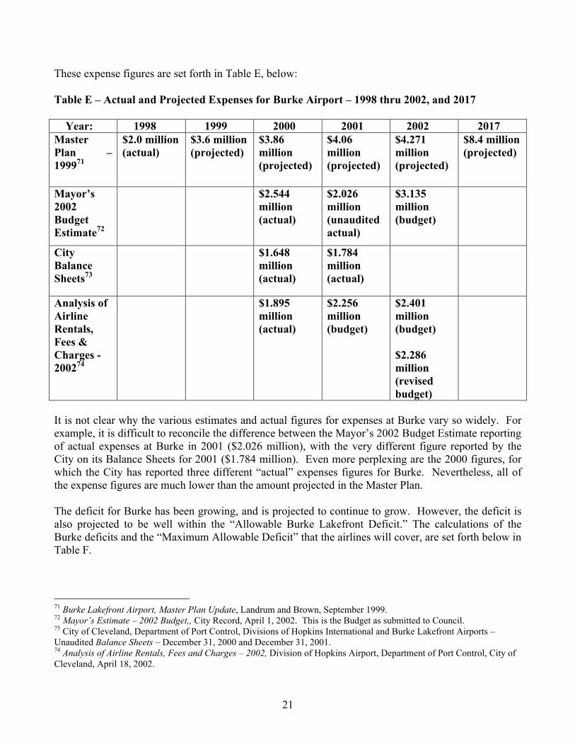
These expense figures are set forth in Table E, below: Table E – Actual and Projected Expenses for Burke Airport – 1998 thru 2002, and 2017 Year: 1998 1999 2000 2001 2002 2017 Master Plan – 199971
$2.0 million (actual)
$3.6 million (projected)
$3.86 million (projected)
$4.06 million (projected)
$4.271 million (projected)
$8.4 million (projected)
Mayor’s 2002 Budget Estimate72
$2.544 million (actual)
$2.026 million (unaudited actual)
$3.135 million (budget)
City Balance Sheets73
$1.648 million (actual)
$1.784 million (actual)
Analysis of Airline Rentals, Fees & Charges - 200274
$1.895 million (actual)
$2.256 million (budget)
$2.401 million (budget) $2.286 million (revised budget)
It is not clear why the various estimates and actual figures for expenses at Burke vary so widely. For example, it is difficult to reconcile the difference between the Mayor’s 2002 Budget Estimate reporting of actual expenses at Burke in 2001 ($2.026 million), with the very different figure reported by the City on its Balance Sheets for 2001 ($1.784 million). Even more perplexing are the 2000 figures, for which the City has reported three different “actual” expenses figures for Burke. Nevertheless, all of the expense figures are much lower than the amount projected in the Master Plan. The deficit for Burke has been growing, and is projected to continue to grow. However, the deficit is also projected to be well within the “Allowable Burke Lakefront Deficit.” The calculations of the Burke deficits and the “Maximum Allowable Deficit” that the airlines will cover, are set forth below in Table F.
71 Burke Lakefront Airport, Master Plan Update, Landrum and Brown, September 1999. 72 Mayor’s Estimate – 2002 Budget,, City Record, April 1, 2002. This is the Budget as submitted to Council. 73 City of Cleveland, Department of Port Control, Divisions of Hopkins International and Burke Lakefront Airports – Unaudited Balance Sheets – December 31, 2000 and December 31, 2001. 74 Analysis of Airline Rentals, Fees and Charges – 2002, Division of Hopkins Airport, Department of Port Control, City of Cleveland, April 18, 2002.

22
Table F – Burke Deficit Calculation – Expenses By Category & Revenues – 2000 - 200275 Deficit Calculation:
2000 2001 (Budget)
2002 (Budget)
2002 (Revised Budget)
Expenses $1,895,230 $2,255,594 $2,400,608 $2,286,038
Revenue $784,462 $882,560 $910,105 $840,000
Capital Expenses
- 0 - - 0 - - 0 - - 0 -
Debt Service for Revenue Bonds
$335,621 $335,676 $335,145 $335,145
Deficit $1,110,768 $1,373,034 $1,490,503 $1,375,933
Maximum Allowable Deficit
$2,195,688 $2,253,297 $2,320,896 $2,320,896
The Master Plan had projected a loss for Burke of $2.7 million in 1999, a deficit of $3.3 million in 2002, and a deficit of $7.4 million by 2017. However, the losses for Burke are now estimated to be much less than those foreseen in the 1999 Master Plan, and less than those stated by some public officials. Impact of Burke on the Cleveland Economy The impact of Burke on the local economy is a difficult issue, and one that is a matter for economists and other experts in the field to evaluate. In making any analysis of Burke’s impact, both the direct and indirect affects of the Airport must be considered; i.e. the impact of the users of the Airport, and the effect of the visitors drawn to the City and downtown by the two large public events held at the Airport, the Air Races and auto race. In addition, while the employment by the City at the Airport is relatively small (below 20 people), the employment created by the lessees and concessionaires must be considered in evaluating the impact of the Airport. NOACA analyzed the economic impact of Burke and the other 4 reliever airports for Hopkins in a 1990 study.76 At that time at Burke, the on-airport employment was 173 full time employees (equivalent.) The application of employment multipliers resulted in an employment impact total of 345 positions. Out of 26,766 itinerant arrivals at Burke, the study concluded that an estimated 22,300 were visitors to the City. (Note: in 2001 Burke had 21,000 itinerant arrivals.) The total payroll impact at Burke was estimated to be more than $6 million. Total output for Burke associated with Airport tenants was estimated at $14.4 million. Output is derived by combining estimated sales, taxes, and average annual capital expenditures for each airport tenant. The total output 75 Id. 76 The Cleveland Airport Reliever Study, Aviation Planning Associates, Inc., Cincinnati, Ohio, on behalf of NOACA, April 1992, at pp. VII-1 to VII-31.

23
impact associated with general aviation visitors was estimated at $4.1 million. The total output impact for Burke was estimated at $22.6 million. This does not include externality effects, such as the impact of the Air Show and auto race. The Future of Burke Lakefront Airport Burke’s main purpose is as a reliever airport for Hopkins International Airport. The importance of Hopkins is therefore tied to the importance of Burke. A report by the City in 1991 stated: “As our region’s primary commercial airport, Cleveland Hopkins International Airport relies upon a system of air traffic reliever airports in order to provide the necessary capacity to accommodate the air travel needs of the Greater Cleveland area. The ability of Hopkins to meet present demand and future growth is only possible if a strong reliever system is in place, and Burke is the major component of that system.”77 The report notes that of five Federally designated Hopkins reliever airports,78 Burke is the only one in the City and under the control and direction of the City. The importance of minimizing delays for the commercial airlines using Hopkins is so important, the report says, that the airlines are willing to underwrite operating deficits at Burke. The advantages of Burke are listed as follows by the City:
• Burke is one of the best equipped of the 5 reliever airports, and is the only one with capabilities to accommodate large aircraft.
• Burke’s location is ideal for business users, and from a noise perspective; its position on the Lake does not generate noise complaints commonly occurring with other landlocked airports.
• In a 1988 survey of pilots using Burke, 77% said that if Burke were unavailable, their first choice as a replacement would be Hopkins.
The City in 1991 believed that Burke’s potential for scheduled commercial airline service “should not be underestimated.” Also, Burke, the City said, is an ideal location for cargo operations because it can handle nighttime and early morning flights without the noise issue. The 1999 Master Plan Update supports the City’s contentions, and lists specific improvements at Burke that are needed to allow it to increase its operations. See Master Plan Recommendations, above. See also, Councilman Michael Dolan’s comments, below, which support the Master Plan’s recommendations. Other proposals have ranged from eliminating Burke as an airport, to keeping the airport, but adding other commercial and business operations or public amenities. One idea is to move Port facilities to the northeast, undeveloped end of the Burke property. This area is the former Confined Disposal Facility (CDF) known as Dike 12. It is presently in the possession of the Port Authority under a Local Cooperation Agreement (LCA) with the Army Corps, which built and filled the CDF Dike 12. The
77 Burke Lakefront Airport: A Critical Link in Greater Cleveland’s Airport System, Department of Port Control, City of Cleveland, February 4, 1991. 78 In addition to Burke, the other reliever airports are Cuyahoga County, Lost Nation (Willoughby, Lake County), Lorain County, and Freedom Field (Medina County).
24
idea is to move and consolidate port facilities, creating a multi-modal Port, with air, water, highway and railroad access.79 Some believe that Burke Airport should be closed in favor of housing, parks and other non-aviation developments. At least one community leader in the development business, speaking anonymously, suggested that the land at Burke could be used best for housing. He noted in a 2002 interview that housing in Cuyahoga County is a concern because of the lack of space for new housing, and particularly medium cost housing. He also asserted that his company has built housing on fill in Chicago, and that housing could be built on Burke, as long as it is not high-rise. A Waterfront Steering Committee issued a report in February 1985 recommending that the western part of Burke be developed for commercial or residential use, that the Airport be maintained, that a bike path be built on its perimeter, and that the eastern end be developed as a waterfront park.80 A Cleveland Waterfront Master Plan Update was issued June 17, 1989 by the Cleveland Waterfront Coordinating Task Force, and presented to Governor Richard Celeste.81 Its recommendation as to Burke was that a study be conducted acceptable to both pro development officials and the FAA to determine the best use of the Airport. The Report did say that they talked to the FAA about the use of the eastern end of Burke for park purposes, but the FAA said it could not be used because it is part of the airport’s clear zone. As to closing Burke, the Task Force found that the FAA is not wedded to Burke as an airport if another site exists as an adequate reliever airport for Hopkins. Finally, the Task Force urges that there not be competing studies by development promoters and the FAA, but rather that a joint study and report be issued by professionals acceptable to both sides. In 1990, the Northeast Ohio Areawide Coordinating Agency (NOACA) commissioned The Cleveland Airport Reliever Study, which was conducted by Aviation Planning Associates, Inc. of Cincinnati, Ohio, and released in April 1992. The study was financed in part by an FAA planning grant. The study reports that three of the 5 reliever airports for Hopkins have towers, Burke, Cuyahoga County and Lost Nation. The FAA operates Burke’s tower while private contractors operate the other two. Burke’s tower operates 24 hours per day, 4 days per week, 23 hours on Fridays, and 16 hours Saturdays and Sundays. Cuyahoga County’s tower operates 16 hours per day, seven days per week, and Lost Nation’s tower operates 14 hours per day, seven days per week. NOACA states that Burke is the primary reliever for Hopkins, due to its location in downtown. Both of Burke’s runways are longer than those of any of the other 4 reliever airports. Burke’s primary runway is 6,198 feet long, and its secondary is 5,200 feet. Cuyahoga County’s longest is 5,101 feet, while Lost Nation’s longest is 5,013 feet. Cuyahoga County has only one runway, as does Lorain. The other 3 have two runways each. Burke has much more itinerant ramp area than the other 4 reliever airports (Burke’s 60,000 square yards vs. Cuyahoga County’s 46,680), and parking (Burke’s 750
79 Proposal of Jim Danek; see IDEABANK for more details – www.ecocitycleveland.org. See also, Interview of Ned Hill, below. 80 Zuchelli, Hunter and Associates of Annapolis, Maryland, and William Behnke of Behnke and Associates, prepared the Committee’s report. The Committee was chaired by William E. McDonald of Ohio Bell Telephone Company, and included a City Council Member, a representative of the Cleveland City Planning Commission, representatives of the Cleveland and Gund Foundations, several presidents of local companies and other executives, attorneys, and private citizens. 81 Co-chairs of the Task Force were Charles L. Butts, State Senator, and Patrick Sweeney, State Representative. The 12 members included representatives of Cleveland City Council, the Port Authority, the Army Corps of Engineers, the non-profit North Coast Development, Flats Oxbow Association, ODNR, the City’s Economic Development Department, a Cuyahoga County Commissioner, and two Congress members.

25
spaces vs. 250 at Cuyahoga County). Burke’s terminal building is also far larger than any other (67,000 square feet vs. 6,000 square feet at Cuyahoga County). However, Burke has only the fourth largest amount of hangar space compared to the other 4 airports—37,665 square feet, vs. 150,326 at Cuyahoga County, 137,385 at Lost Nation, and 41,000 at Lorain. In 1990 Burke had 73 based aircraft, which increased to 80 by 2002, while Cuyahoga County had 126 based aircraft (a 55 aircraft decrease from 1986.) In 2002 Cuyahoga County has 186 based aircraft. Lost Nation had 144 based aircraft in 1990, Lorain had 115, and Medina had 68. Burke had the highest number of operations in 1990 among the 4 reliever airports. The based aircraft mix between Burke and Cuyahoga County was fairly similar in 1990: Table G – Based Aircraft Mix Comparing Burke Airport and Cuyahoga County Airport
Airport
Single Engine Aircraft
Multi- Engine Piston Aircraft
Multi- Engine Turboprop
Jet Aircraft
Rotorcraft Aircraft
Burke
56%
10%
11%
14%
10%
Cuyahoga County
57%
15%
10%
17%
1%
The operational fleet mix comparing Burke and Cuyahoga County was fairly similar in 1990: Table H – Operational Fleet Mix Comparing Burke Airport and Cuyahoga County Airport
Airport
Single Engine Aircraft
Multi- Engine Piston Aircraft
Multi- Engine Turboprop
Jet Aircraft
Rotorcraft Aircraft
Burke
65%
10%
8%
8%
9%
Cuyahoga County
62%
14%
10%
13%
1%
About 43% of Burke’s operations were local in 1990, with 57% itinerant, while Cuyahoga County had 40% local operations and 60% itinerant. (That had changed to 20% local, and 66% transient in 2002.)82 Burke had by far the highest hourly capacity, a figure calculated from operations numbers, fleet mix, runway and taxiway configuration and weather conditions. Burke’s high capacity was attributable to
82 AirNav.com, www.airnav.com, 9/16/02.

26
the airport’s parallel runways. Another statistic is annual service volumes, a reasonable estimate of an airport’s annual operational capacity based on weighted hourly capacity and a ratio of annual operations to average daily operations in the peak month of the year. Cuyahoga County had the lowest estimated annual service volumes among the 5 reliever airports. Burke was second last. The based aircraft mix between Burke and Cuyahoga County in 2002 was as follows in Table I: Table I – Based Aircraft Mix Comparing Burke Airport and Cuyahoga County Airport - 200283
Airport
Single Engine Aircraft
Single Engine Share
Multi- Engine Aircraft
Multi- Engine Share
Jet Aircraft
Jet Share
Rotor craft Aircraft
Rotor craft Share
Burke
52
65%
13
16%
4
5%
11
14%
Cuyahoga County
91
48.5%
13
7%
81
44%
1
.5%
Noise is considered a development constraint at Cuyahoga County Airport, though not at Burke. The 1992 NOACA study concluded that should one of the reliever airports close, the system would be deficient in geographical coverage, operational capacity, storage capacity or all three. If this occurs, another airport in the immediate geographic area will be required. If a closure occurs, NOACA recommends that follow on studies be conducted to determine the exact location, size and role of the replacement airport.84 In 1993, the City released its Master Plan for Burke, announcing an $80-120 million expansion and development plan for Burke.85 The Plans included building a 4,000 foot runway in the northeast corner of the airport property within the next 10 years, diking and filling a 70 acre site on the north side of the airport (which is now the active CDF, Dike 10B), building a 5,400 foot runway on the landfill site within 20 years, turning the 4,000 foot runway into a taxiway, removing smokestacks at Cleveland Public Power, purchasing all weather landing equipment, constructing support facilities including a new tower, eliminating the current taxiway to allow for economic development, building three new hangars, and renovating the terminal. Also, the City said it would hire a marketing firm for Burke. The City planned to pay for the improvements with revenue bonds, to be paid for through landing fees at Burke and Hopkins, and FAA grants. The all weather instruments for landing and the removal of the CPP stacks have been accomplished. The 1999 Master Plan Update revised some of the plans, and also extended the need for some expansion to 2017.
83 AirNav.com, www.airnav.com, 9/16/02. 84 The Cleveland Airport Reliever Study, Aviation Planning Associates, Inc., Cincinnati, Ohio, on behalf of NOACA, April 1992, at pp. IV-16 and IV-18. 85 Clearance sought to upgrade Burke, Cleveland Plain Dealer, February 11, 1993, at p. B1.

27
In a 1997 report entitled The Future of Northeast Ohio’s Airports: Framing the Coming Debate, issued October 14, 1997, Professor Edward Hill of Cleveland State University, and Editor of “Economic Development Quarterly,” proposed ideas to deal with the region’s air service needs. He noted that even after Hopkins is expanded it will be incapable of handling the increased volume of air service demand. For a number of reasons he concludes that the solution is to maximize existing air service capacity and in making incremental investments that improve the competitive position of all Northeast Ohio airports. Yet he raises the question as to whether over the long term Burke should stay in operation. For one, he asks whether increased traffic at Hopkins will interfere with Burke’s flight operations. He also questions whether Burke’s business is better suited for either Akron-Canton or a smaller airport, such as Cuyahoga County, and whether the Burke property is better suited for housing and recreation. The Greater Cleveland Growth Association created an “Air Service Strategic Planning Task Force,” that issued a report on September 15, 1998 entitled Analysis of Air Service Demand and Capacity for the Cleveland Region. It mainly discusses Hopkins, and the need for expansion of that airport. The only comment on Burke states: “Expansion of existing facilities at Burke to supplement Hopkins also could advance economic objectives in that they are well located vis-à-vis a substantial segment of the flying public. Burke’s development and expansion would strengthen downtown development—primarily its tourist/convention industries.” The City of Cleveland’s Civic Vision 2000 Plan proposed to keep the airport use, due to its critical role in the region’s airport network. Civic Vision also urged that the airport be moved to the north and east on existing and new fill. The Plan also proposes developing 6 acres on the western end of Burke for non-aviation uses. In addition, The Plan recommended improvements on the southern side of Burke to enhance its appearance and mitigate its negative impact on surrounding downtown development. The main improvement was the proposal to add a double row of trees adjacent to the bike trail along North Marginal Road. A report issued by Oster Research Group of Ankeny, Iowa,86 in May 2002, entitled a Survey of the Need, Resources and Opportunities for Revitalization of Greater Cleveland, identifies Burke as a “premier” site for large scale developments in the downtown area. Bike Path Around Perimeter The construction of a bike path anywhere on Burke Airport grounds is problematic due to security concerns, and the cost of fencing and possibly additional security measures, such as video cameras. It would also be of possible concern to the FAA due to its regulations for safety zones at airports. Yet it appears that the issue has not been specifically addressed by the FAA or the City. In grant agreements with the FAA that the City has signed, the City has agreed to “prevent the erection or creation of any structure or place of public assembly in the Runway Protection Zone.”87 The FAA must approve any structure or uses in the Zone. The Runway Protection Zone (RPZ) is a trapezoid shaped imaginary area extended out from the end of each runway centerline to protect people and property on the ground. It begins 200 feet beyond the end of the runway and its size depends on the size of aircraft using the airport and visibility minimums. There are also Runway Object Free Areas
86 The report was obviously commissioned by a local entity, possibly a private corporation with an interest in the outcome. However, the report does not identify the purpose or sponsor of the report. 87 General Airport Grant Agreement between the City of Cleveland and FAA, dated June 13, 1995.
28
(OFA), which surround the runway and in which parked objects are prohibited, and the area must be on land that is clear and graded. Controlled Activity Areas (CAA) are a portion of the RPZ beyond and to the sides of the OFA, that is required to be free of uses creating glare or smoke, and in which the construction of roads is not recommended. Runway Safety Areas (RSA) along and at the end of runways must be clear, graded, without ruts or surface variations.88 It is possible that a bike path, and the fencing surrounding the airfield that would likely be necessary, could be obstructions that would violate FAA regulations. The FAA must approve any use of property for a bike path, and must “release” the property for non-aviation use. The release procedure can be cumbersome and take a fairly long time. A perimeter bike trail was endorsed by the 1985 Mayor’s Waterfront Steering Committee.
Interest Groups and Individuals Interested in Burke’s Future There are obvious entities with an interest in Burke’s future – the City of Cleveland, the Mayor and her Administration, as well as City Council. Groups that have shown a keen interest include other public officials (i.e. County Commissioners, State legislators, the Governor), the FAA, the Greater Cleveland Growth Association, and the tenants and users of Burke. Groups that have shown an interest in closing Burke, or incorporating public amenities and access, include many local environmental and citizen organizations, as well as developers. The Aircraft Owners and Pilots Association has said that it is committed to keeping Burke open as an airport. This group mounted a lobbying and public relations blitz in Chicago in 2001 when the mayor proposed to close Meigs Airport. In the end that airport will likely remain open for another 25 years.89 Councilman Cimperman, in whose ward Burke is situated, has spoken openly in favor of closing Burke.90 Councilman Dolan has stated the opposite. See Interview below. Interviews Edward W. Hill, Professor in Urban Studies and Public Administration At the Maxine Goodman Levin College of Urban Affairs, Cleveland State University Friday, August 30, 2002; By: David Beach [edited summary of conversation] Professor Hill stated that it is a basic principle that the use of the lakefront (and Burke) should be tied to making a viable downtown. He said that downtown needs 25,000 residents to be viable. The lakefront is an amenity that should be used to attract residents. The residents will then help the downtown office market (by creating a street life that the suburbs can’t offer) and give downtown an economic purpose. Otherwise, jobs will continue to bleed to the suburbs, which offer location and transportation advantages. Suburban office rents are higher now, which means that there is no business advantage to be downtown.
88 Burke Lakefront Airport, Master Plan Update, Landrum and Brown, September 1999. 89 Saviors of Chicago’s Meigs Field say they’ll fight for Burke Airport, Cleveland Plain Dealer, June 21, 2002, at p. B2. 90 Id.

29
The opportunity cost of the land is the big issue; i.e. how to increase its value for the city and the region. The asset of Lake Erie needs to be brought into play. The “visitor destination” strategy is not sufficient. People visit great cities, not attractions. Professor Hill questioned whether Burke is a business asset. He said that this has been tried for 25 yrs, and it hasn’t worked. It’s not a business amenity. Passive recreation might be a better use if it will attract a residential base and then boost the commercial real estate base. Burke’s problems: It made an operating profit while the Cleveland Federal Reserve Bank was processing checks, but the Fed lost the contract to Richmond Fed. Now Burke is losing money – Mike Dolan estimates $2-3M/yr loss. Only Akron-Canton (A-C) and Hopkins make money. He raises the issue that if Burke closes, the City could use the savings to lower landing fees at Hopkins. He says that most of Burke’s flight operations are flight school operations. Burke is not the prime diversion airport for Hopkins – A-C is 1st, Youngstown is 2nd, Mansfield is 3rd. A-C can provide relief to Hopkins, and A-C offers increasing locational advantages – sprawl is moving the market for air travel closer to A-C. General aviation airports in the region offer lots of capacity. He suggests that Burke has a wind sheer problem for planes. He also raises the issue that if Burke is too essential to close permanently, how can it be closed for air shows and car races? He also suggests that the FAA payback if Burke were to close as an airport is only $7 million. That is not a great amount, and we could argue that if we prepare a regional air plan, we should be able to avoid a one-time payback. FAA legislation dates to the 1940s and needs to be changed anyway. Geotechnical issues: A public, neutral, engineering study of what can be built there is needed. 4 possible scenarios for Burke:
1) Keep it as an airport, but create a lakefront park with bikeway, with an expansion of museums at the western end, and a new urban neighborhood along the south edge.
2) Keep Burke as an airport, but move the Port to the east end of Burke and create a multi-modal facility with bike path along water’s edge, and a museum campus on the west end. Open up Warehouse District to the waterfront.
3) No change. 4) Close the airport, create passive park, bank the land for future uses. Why do local politics favor keeping Burke? Due to the desire to keep a City asset, patronage jobs (though not many), FAA, and the lack of vision.

30
Thomas P. Slavin, President, Burke Lakefront Services, Inc., dba Million Air 1601 N. Marginal Road; Cleveland, Ohio 44114; Telephone: (216) 861-2030; Fax: (216) 861-3119 Monday, July 22, 2002 – by: William M. Ondrey Gruber and Joanne Kaufman Mr. Slavin believes that Burke needs to be expanded, and that it is an “economic engine.” He says that there are 100,000 “movements (i.e. take-offs and landings) annually at Burke, and about 275,000 movements at Hopkins Airport. He says that Burke’s usage is growing while Hopkins’ is decreasing. Mr. Slavin states that Burke serves general aviation needs such as: Metro Life, MBNA, Channel 5 Television station, Gulfstream, medical flights for Metro and for transplants, international clientele going to the Cleveland Clinic, telecommunications firms, corporate firms, sports teams, recreational fliers and air freight. He says that Burke is needed because Hopkins is the busiest single runway airport in the country, even with expansion. If Burke closes, he insists, ¾ of the usage would go to Hopkins. When we discussed the situation of Meigs Field in Chicago, he said that Burke is 2 ½ times busier than Meigs, and that the Chicago airport is much more constrained in its capacity. For example, he says that 737 and 757 aircraft can and do use Burke while Meigs cannot handle such aircraft. He mentioned that Meigs is owned by the Chicago Parks Authority, while here Burke is owned by the City’s Department of Port Control. He noted that the idea of housing and some other uses are prevented or made more difficult due to the environmental condition of the soils. Also, he said that the high water table, only 3-4 feet down into the ground, makes basement construction impossible. He noted that his company, Million Air, is expanding operations at Burke, and is going to be building a new building when the permits are all obtained. He says that his company has over 100 employees. In this time in our history he says that the business community is moving away from scheduled airlines, so that airports like Burke, and the type of private and charter aircraft it serves will be in greater demand. In addition, the “just in time” (JIT) concept of air freight is expanding, which he says Burke can serve well. He noted that this type of business has grown at airports in Cincinnati, Dayton, Columbus and Toledo. Moreover, he says outsourcing of flights and fractional ownership of aircraft, is the greatest area of growth in the industry. He says Burke could be well positioned to take advantage of this growth. He suggests that Burke be:
1. privatized; 2. expanded; and 3. the periphery be developed.
As to expansion, he says that more hangars are needed and a major maintenance facility. The City needs to offer lessees unsubordinated land leases on a long-term basis—such as 20 years. Also, better terms more favorable to business users are needed. The City also needs to address the environmental concerns so that business at Burke can expand, or at least offset the environmental concerns with lower rental. He also says that a longer runway is needed.

31
As to Burke’s operations, he says that it has endured years of mismanagement. He says that lessees at Burke pay too much in rent, that the City interferes in their operations and that talk of closing Burke hurts business. He asserts that the management at Burke has been unprofessional, and the City has been hiring managers who may be intelligent but do not know the business of running an airport. Due to the mismanagement, he relates, the City has lost very good people like Mike Barth. Even the City’s Master Plan developed two years ago for Burke by Landrum and Brown, he says, was poorly done and was never approved by the Mayor or Council. He says that the City also must employ a more aggressive marketing strategy for Burke. He noted that in Toledo public officials used political clout to win business at their airport. He claims that the FAA has told Councilman Cimperman that they will not allow closure of Burke. Michael Dolan, Cleveland City Councilman, Ward 21 September 14, 2002 Councilman Dolan objects to Burke Airport being closed because the region lacks air service capacity and airports are the greatest economic development engines a community can have. The City needs Burke. Besides, park use is not the highest and best use of the land at Burke. Housing or other development on a landfill raises its own problems. Burke is unavoidably attached to the hip to Hopkins. We are among the largest metropolitan areas, yet Hopkins only has one functional runway. The two runways at Hopkins are only spaced 400 feet apart, so only one can be used at a time. We are building another runway that will give the City a 1.4 runway capacity, due to the distance between the runways. In his opinion the best possible and realistic scenario for Hopkins is to have two independent runways, 3600 feet apart, with sophisticated technology for runway monitoring. Yet every other airport we compete with has at least 3 independent runways—Cincinnati, Detroit, Pittsburgh, etc. They have 2.6 times the capacity of Cleveland to operate. The problem is that there has been little planning or development at Burke. The Burke Master Plan “Update” of 1999 was just a rehash of the 1992 Plan. Smaller planes still use Hopkins. Hopkins could benefit from perhaps a 7-10% capacity gain if the smaller aircraft used Burke instead. We should move general aviation from Hopkins. But Burke lacks hangar space. Burke needs hangars, a “bird to turn” system, and a customs agent. There are regional airlines that could be potentially lured to Cleveland. The City may have used up bonding ability, so the City lacks funds to expand Burke. But, private companies would likely be interested in investing at Burke if the City offered favorable terms. Why not make Burke a free port, he asked. David Goss, Greater Cleveland Growth Association July 3, 2002 Mr. Goss said that the Regional Business Council is undertaking an evaluation of air service needs in the region. It is not yet completed. It will deal with Burke. It would include an analysis by experts of the problems associated with the use of the Burke property.

32
Conclusions Although this project does not require the authors to draw conclusions from the information gathered, there are some observations that are worth noting:
1. Most of the official reports and studies on Burke have, not surprisingly, been conducted by entities that want Burke to remain as an airport or who have a vested interest in it remaining an airport.
2. The community needs to decide one way or another whether Burke will remain an airport or be
closed and the land used for something else. The issue being raised every few years, or continuously, has a negative effect on the full development of the Airport, if it is to remain as such.
3. If the Airport is improved as proposed in the 1999 Master Plan Update, or as proposed by
several persons interviewed, there are ramifications for other possible ideas for the Airport’s future:
a. can the air race, and particularly the auto race, continue at Burke if it is developed as
proposed? b. If the development plans in the Master Plan are implemented, the idea of moving
the Port Authority facilities to Dike 12 at the eastern end of Burke could not be accomplished.
c. The Master Plan, and no other plan or study that we received and reviewed, included an analysis or study of whether, if it is built (i.e. developed further as called for in the Master Plan and several persons interviewed believe is necessary), will businesses come?
4. Any proposed non-aeronautical use within Burke’s property boundary requires a release
analysis and FAA approval (and may require an environmental study as well.)
5. Before the City can proceed with the Master Plan or any other major investment, an economic analysis and user study should be done, or if already done by someone, then it should be incorporated into a Master Plan re-Update or a new Master Plan. The City’s 1999 Master Plan Update has been criticized as incomplete, and not approved by the FAA, as well as just a rehash of the Master Plan done in the early 1990s. The 1999 Plan did not even consider any park or recreational uses, either for all of Burke, or for any part of the Burke property. It simply assumed continuation of Burke fully for aviation uses. The 1981 Master Plan at least mentions non-aviation uses, and even states that it is recommended that any expansion of Burke should incorporate the development of recreational facilities, such as hiking and bicycle trails, where appropriate.91
6. As a warning to those hoping to close Burke and turn it into a park, it should be noted that if
Burke is ever closed as an airport, the most likely reason for the closing (that is, the persons who will have succeeded in achieving the closure) will be for development of the 480 acres for housing and commercial enterprises. The most difficult scenario to achieve is to close Burke in
91 Final Report, Master Plan Study, Burke Lakefront Airport, prepared by Peat, Marwick, Mitchell & Co., San Francisco, California, December 1981.

33
order to create a large waterfront park. Of course, housing and commercial development could include access to the waterfront for the public and some park amenities. Also, the most polluted waters on the City’s lakefront are those to the east of the Cuyahoga River mouth, including those along Burke Airport’s property.
7. The community needs to find a new site for a Confined Disposal Facility (CDF) for dredgings from the harbor and River for shipping traffic and recreational boating. Dike 10B will be filled in approximately 7-10 years, and the planning time for a new CDF is up to 10 years. Also, the local community will have to pay a large share of the cost for the first time, since the Federal government is no longer paying 100% of the cost. Where a new CDF is placed on the lakefront will have a potentially great effect on Burke, the Port Authority, recreational use or other uses of the lakefront. This issue must be taken into consideration in any planning for Burke and the future of the lakefront.

34
BKL Burke Lakefront Airport
A Report on its History, Its Current Status and Its Future
Prepared for: The BLUE Project Building the Livable Urban Edge A partnership of the Cleveland Waterfront Coalition and EcoCity Cleveland. The BLUE Project is intended to foster new ideas and build public support for a dramatically better waterfront in Greater Cleveland — a waterfront with world-class public access and ecological quality. The project is funded by the George Gund Foundation and the Raymond John Wean Foundation. Its purpose is to:
• Identify a full range of "big picture" concepts and approaches for waterfront planning (such as the style of waterfront that is appropriate for Cleveland).
• Research critical issues for waterfront development (such as the possibilities for converting Burke Lakefront Airport to other uses).
• Research best practices for urban waterfronts. • Assure an exemplary public process for waterfront planning. • Stimulate the civic imagination about waterfront alternatives — and how a great
waterfront can contribute to the life of a city. The BLUE Project is independent of the City of Cleveland's lakefront planning process, which just began a series of public meetings. But BLUE will coordinate with the city process and supplement the city's efforts. For More Information:
EcoCity Cleveland 2841 Scarborough Road Cleveland Heights OH 44118 Cuyahoga Bioregion (216) 932-3007; www.ecocitycleveland.org
Report Prepared By: William M. Ondrey Gruber Research Consultant

35
Attorney at Law Joanne Kaufman 2714 Leighton Road Cleveland, Ohio Shaker Heights, Ohio 44120 (216) 371-3570 Fax: (801) 697-4625 E-Mail: [email protected] September 17, 2002