building crowd-sourcing and social media into your gis€¦ · anatomy of a tweet downtown la....
TRANSCRIPT

Building Crowd-Sourcing and Social Media into your GIS
@agup, @AL_Laframboise

Agenda
• Tweets and Geolocation• Using the Twitter APIs• Research and Development

Anatomy of a tweet
Downtown LA. Traffic accident on I10. Backed up for miles. Anyone know how the I60 is? #Traffic
WhatWhat’’s happening?s happening?
To whom?To whom?
GeolocationGeolocation??
34.063634.0636
‐‐117.5922117.5922

How do I access Twitter location data?
Search API + geocode•Twitter geotag <twitter:geo>
•Profile location <google:location>
•The tweet content (text and/or hashtags)
REST API•User status <location>
STREAMS API•locations (bounding box)

Architectures for integrated Tweets
• Client only- Browser- Desktop (e.g. Adobe AIR)
• Client/Server

Client-only
Web Web
WebWebClientClient
BasemapBasemap
Geo ServicesGeo Services
TwitterTwitter
GeodatabaseGeodatabase
ArcGIS ServerArcGIS Online
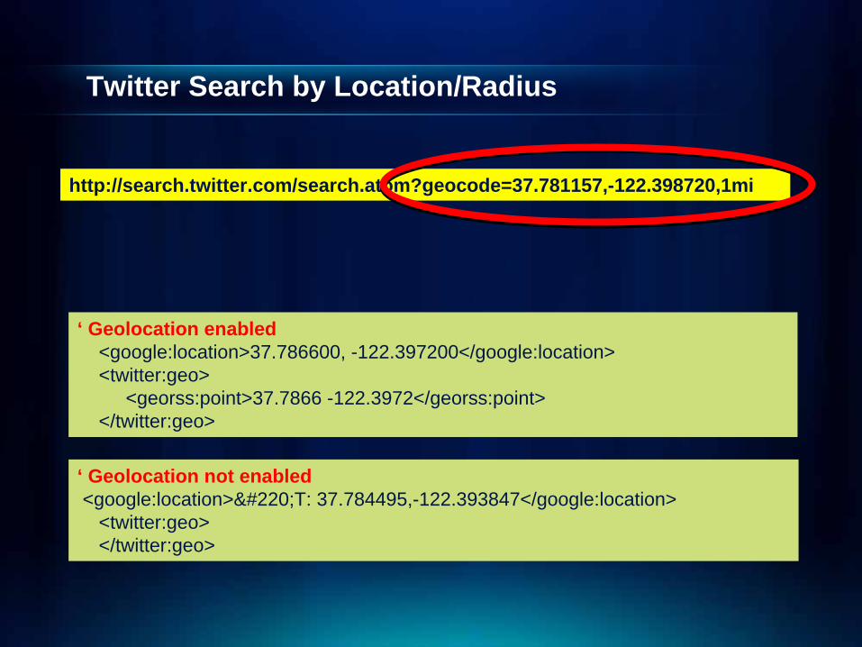
Twitter Search by Location/Radius
http://search.twitter.com/search.atom?geocode=37.781157,-122.398720,1mi
‘ Geolocation enabled<google:location>37.786600, -122.397200</google:location><twitter:geo>
<georss:point>37.7866 -122.3972</georss:point></twitter:geo>
‘ Geolocation not enabled<google:location>ÜT: 37.784495,-122.393847</google:location>
<twitter:geo></twitter:geo>

Geo-components of radius search payload<entry>
<id>tag:search.twitter.com,2005:45270965835407360</id><published>2011-03-08T23:53:34Z</published><link type="text/html"
href="http://twitter.com/cobradave/statuses/45270965835407360" rel="alternate"/>
<title>@AvaAddams even tho prefer the usual size, thanks for sharing the pic :)</title>
<content type="html"><a href="http://twitter.com/AvaAddams">@AvaAddams</a> even tho prefer the usual size, thanks for sharing the pic :)</content>
<updated>2011-03-08T23:53:34Z</updated><link type="image/png"
href="http://a2.twimg.com/profile_images/82614151/bg_davy_icon_normal.j pg" rel="image"/>
<google:location>37.786600, -122.397200</google:location><twitter:geo>
<georss:point>37.7866 -122.3972</georss:point></twitter:geo>****
</entry>
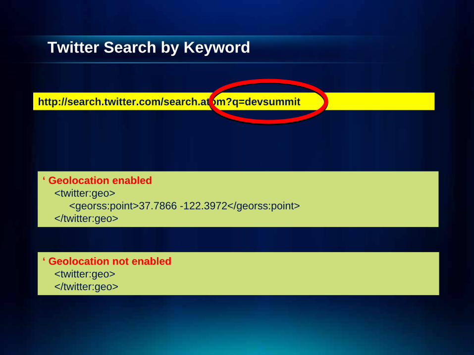
Twitter Search by Keyword
http://search.twitter.com/search.atom?q=devsummit
‘ Geolocation enabled<twitter:geo>
<georss:point>37.7866 -122.3972</georss:point></twitter:geo>
‘ Geolocation not enabled<twitter:geo></twitter:geo>

Geo-components of keyword search payload
<entry><id>tag:search.twitter.com,2005:45341439764348929</id><published>2011-03-09T04:33:36Z</published><link type="text/html"
href="http://twitter.com/ronboug/statuses/45341439764348929" rel="alternate"/>
<title>RT @timoreilly: Cool hack by @sharpgis lets you control a map, kinect-style. I try it. Pic via @RyanResella http://bit.ly/eKvs4v at ESRI #devsummit</title>
<content type="html">RT <a ........</content><updated>2011-03-09T04:33:36Z</updated><link type="image/png"
href="http://a0.twimg.com/profile_images/319278276/topStory6_n ormal.jpg" rel="image"/>
<twitter:geo></twitter:geo>****
</entry>
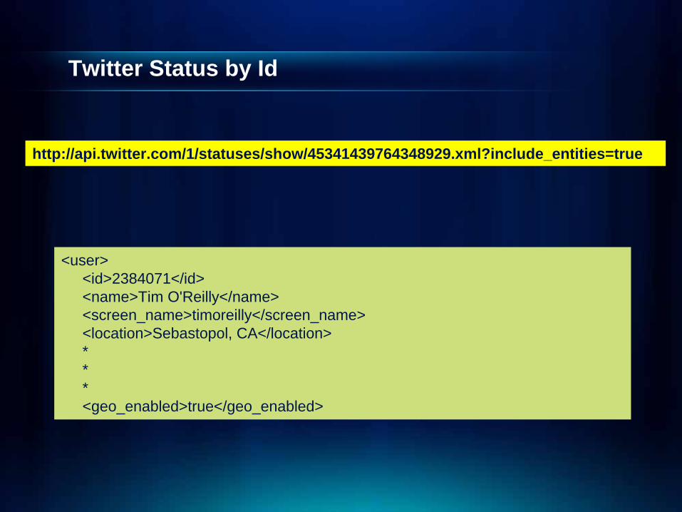
Twitter Status by Id
http://api.twitter.com/1/statuses/show/45341439764348929.xml?include_entities=true
<user><id>2384071</id> <name>Tim O'Reilly</name><screen_name>timoreilly</screen_name><location>Sebastopol, CA</location>***<geo_enabled>true</geo_enabled>

Client-side Twitter Request (GET or POST)
try{
var reqURI:String = PROXY_SERVER + "tweetcmd.php?" + attrs;
var httpService:HTTPService = new HTTPService;httpService.url = reqURI;httpService.requestTimeout = 30; httpService.useProxy = false;httpService.method = "GET"; httpService.resultFormat = "text"; //IMPORTANT: you must use the 'text' valuehttpService.addEventListener( "result", twitterSearchResult );httpService.addEventListener( "fault", twitterSearchFault );httpService.showBusyCursor = true;httpService.send();
}catch( error:Error ){
dispatchEvent(new TweetEvent(TweetEvent.SEARCH_FAILED,error.getStackTrace()));
}
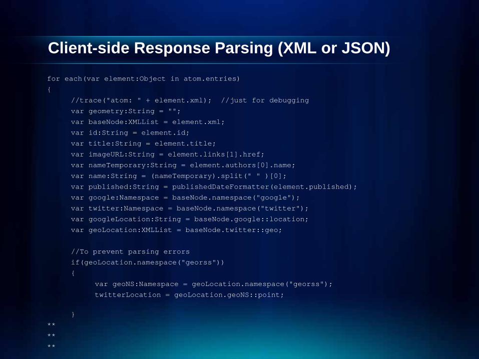
Client-side Response Parsing (XML or JSON)for each(var element:Object in atom.entries)
{
//trace("atom: " + element.xml); //just for debugging
var geometry:String = "";
var baseNode:XMLList = element.xml;
var id:String = element.id;
var title:String = element.title;
var imageURL:String = element.links[1].href;
var nameTemporary:String = element.authors[0].name;
var name:String = (nameTemporary).split(" " )[0];
var published:String = publishedDateFormatter(element.published);
var google:Namespace = baseNode.namespace("google");
var twitter:Namespace = baseNode.namespace("twitter");
var googleLocation:String = baseNode.google::location;
var geoLocation:XMLList = baseNode.twitter::geo;
//To prevent parsing errors
if(geoLocation.namespace("georss"))
{
var geoNS:Namespace = geoLocation.namespace("georss");
twitterLocation = geoLocation.geoNS::point;
}
**
**
**

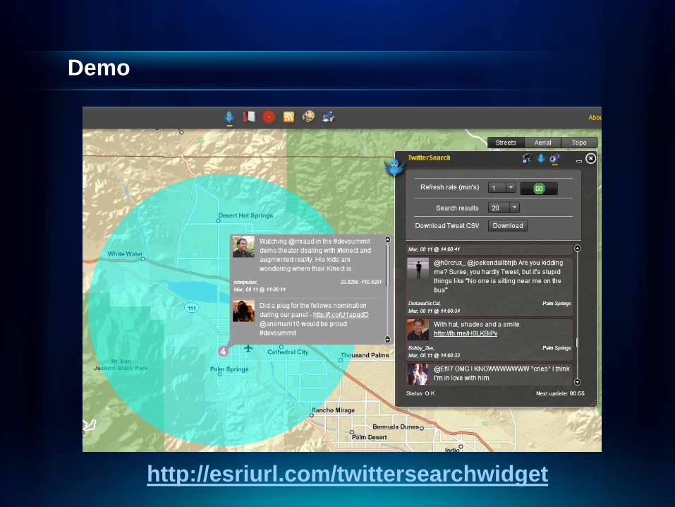
Research and Development
ArcGIS Explorer

ArcGIS Explorer – Twitter Add-in
http://tinyurl.com/agxtwitter

Framework

Login (oAuth)
Token
Authorization
Cache

Getting Friends and Favorites (oAuth)
Friends
Favorites

Search by distance or keyword (oAuth)
Search by Radius- Optional keyword
Search- Optional keyword

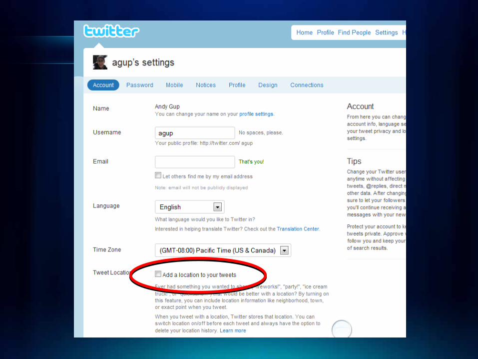
GeoTagging – Are you enabled?
Ask user!
See Twitter dev guide!

GeoTagging Tweets
Append coordinates
Users must geo-enable (opt-in) accounts
string url = http://api.twitter.com/statuses/update.xml;string status = “At the Devsummit learning lots of cool things… #devsummit”;
string request = string.Format("lat={0}&long={1}&status={2}", lat, lon, status);
‘ Geolocation enabled</user>
<geo xmlns:georss="http://www.georss.org/georss"> <georss:point>34.056758 -117.196006</georss:point>
</geo></status>
‘ Geolocation not enabled</user>
<geo /></status>
34.063634.0636
‐‐117.5922117.5922

Geolocation = Spatial Context

Learn more…
http://support.twitter.com/forums/26810/entries/78525

Features
Geocode Tweets
GeoTag Tweets
Show GeoTag
Zoom Levels
2D/3D
Search
Float or Pin
Show Notes
Follow Users
Unfollow Users

Challenges
• Point dispersion
• Paging (1500)
• Storage
• Search Limitations (7-days)
• Rate Limits

Development Considerations
• Choose Twitter API(s) • Native HTTP request/response• Authentication• Parsing out location data• Rate Limits
- IP Address Whitelisting (contact Twitter)*
• Storing data limitations (contact Twitter)*
*Email: [email protected]

Questions
