brownfield pboa pre nomination study city of rochester
TRANSCRIPT

Brownfield PBOA Pre‐Nomination Study
City of Rochester Bull’s Head Neighborhood
Sep tembe r 2011
Submitted By: City of Rochester, New York
Department of Neighborhood and Business Development
Prepared By:


City of Rochester Clark Patterson Lee
Bull’s Head Neighborhood Pre-Nomination Study
TABLE OF CONTENTS
Section 1: Description of Project and Boundary Introduction ........................................................................................................................... 1-1
Community Overview and Description ................................................................................. 1-1
Project Overview and Description ......................................................................................... 1-4
Community Vision & Goals and Objectives ........................................................................... 1-5
Brownfield PBOA Boundary Description and Justification .................................................. 1-8
Opportunities and Constraints ............................................................................................... 1-9
Section 2: Preliminary Analysis of the Brownfield Area
Existing Land Use and Zoning .............................................................................................. 2-1
Brownfield, Abandoned and Vacant Sites .............................................................................. 2-6
Land Ownership ..................................................................................................................... 2-9
Natural Resources .................................................................................................................. 2-9
Summary of Preliminary Analysis and Recommendations .................................................... 2-9
Maps
Community Context ......................................................................................................... Map 1
Study Area Context ........................................................................................................... Map 2
BOA Boundary .................................................................................................................. Map 3
Existing Land Use ............................................................................................................. Map 4
Existing Zoning Districts .................................................................................................. Map 5
Underutilized Sites ............................................................................................................ Map 6
Land Ownership Patterns .................................................................................................. Map 7
Natural Resources ............................................................................................................. Map 8
Appendix Photo Inventory of Conditions ................................................................................ Appendix A
All images © Clark Patterson Lee unless otherwise noted.

City of Rochester Clark Patterson Lee
Bull’s Head Neighborhood Pre-Nomination Study
- Section 1 -
Description of Project and Boundary

Project Description
1-1
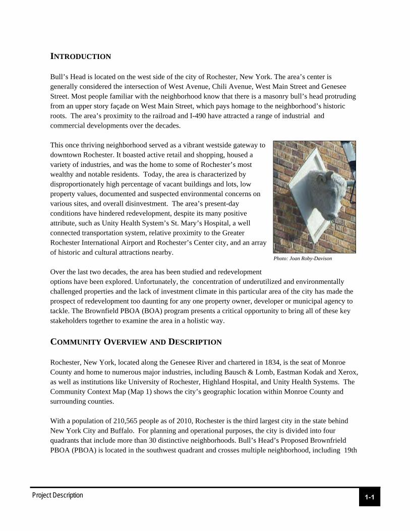
INTRODUCTION Bull’s Head is located on the west side of the city of Rochester, New York. The area’s center is generally considered the intersection of West Avenue, Chili Avenue, West Main Street and Genesee Street. Most people familiar with the neighborhood know that there is a masonry bull’s head protruding from an upper story façade on West Main Street, which pays homage to the neighborhood’s historic roots. The area’s proximity to the railroad and I-490 have attracted a range of industrial and commercial developments over the decades. This once thriving neighborhood served as a vibrant westside gateway to downtown Rochester. It boasted active retail and shopping, housed a variety of industries, and was the home to some of Rochester’s most wealthy and notable residents. Today, the area is characterized by disproportionately high percentage of vacant buildings and lots, low property values, documented and suspected environmental concerns on various sites, and overall disinvestment. The area’s present-day conditions have hindered redevelopment, despite its many positive attribute, such as Unity Health System’s St. Mary’s Hospital, a well connected transportation system, relative proximity to the Greater Rochester International Airport and Rochester’s Center city, and an array of historic and cultural attractions nearby. Over the last two decades, the area has been studied and redevelopment options have been explored. Unfortunately, the concentration of underutilized and environmentally challenged properties and the lack of investment climate in this particular area of the city has made the prospect of redevelopment too daunting for any one property owner, developer or municipal agency to tackle. The Brownfield PBOA (BOA) program presents a critical opportunity to bring all of these key stakeholders together to examine the area in a holistic way.
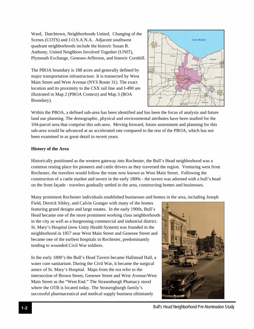
COMMUNITY OVERVIEW AND DESCRIPTION Rochester, New York, located along the Genesee River and chartered in 1834, is the seat of Monroe County and home to numerous major industries, including Bausch & Lomb, Eastman Kodak and Xerox, as well as institutions like University of Rochester, Highland Hospital, and Unity Health Systems. The Community Context Map (Map 1) shows the city’s geographic location within Monroe County and surrounding counties. With a population of 210,565 people as of 2010, Rochester is the third largest city in the state behind New York City and Buffalo. For planning and operational purposes, the city is divided into four quadrants that include more than 30 distinctive neighborhoods. Bull’s Head’s Proposed Brownfrield PBOA (PBOA) is located in the southwest quadrant and crosses multiple neighborhood, including 19th
Photo: Joan Roby-Davison
1-2
Bull’s Head Neighborhood Pre-Nomination Study
Ward, Dutchtown, Neighborhoods United, Changing of the Scenes (COTS) and J.O.S.A.N.A. Adjacent southwest quadrant neighborhoods include the historic Susan B. Anthony, United Neighbors Involved Together (UNIT), Plymouth Exchange, Genesee-Jefferson, and historic Cornhill. The PBOA boundary is 188 acres and generally defined by major transportation infrastructure. It is transected by West Main Street and West Avenue (NYS Route 31). The exact location and its proximity to the CSX rail line and I-490 are illustrated in Map 2 (PBOA Context) and Map 3 (BOA Boundary). Within the PBOA, a defined sub-area has been identified and has been the focus of analysis and future land use planning. The demographic, physical and environmental attributes have been studied for the 104-parcel area that comprise this sub-area. Moving forward, future assessment and planning for this sub-area would be advanced at an accelerated rate compared to the rest of the PBOA, which has not been examined in as great detail in recent years. History of the Area Historically positioned as the western gateway into Rochester, the Bull’s Head neighborhood was a common resting place for pioneers and cattle drivers as they traversed the region. Venturing west from Rochester, the travelers would follow the route now known as West Main Street. Following the construction of a cattle market and tavern in the early 1800s - the tavern was adorned with a bull’s head on the front façade - travelers gradually settled in the area, constructing homes and businesses. Many prominent Rochester individuals established businesses and homes in the area, including Joseph Field, Derrick Sibley, and Calvin Granger with many of the homes featuring grand designs and large estates. In the early 1900s, Bull’s Head became one of the more prominent working class neighborhoods in the city as well as a burgeoning commercial and industrial district. St. Mary’s Hospital (now Unity Health System) was founded in the neighborhood in 1857 near West Main Street and Genesee Street and became one of the earliest hospitals in Rochester, predominantly tending to wounded Civil War soldiers. In the early 1800’s the Bull’s Head Tavern became Hallstead Hall, a water cure sanitarium. During the Civil War, it became the surgical annex of St. Mary’s Hospital. Maps from the era refer to the intersection of Brown Street, Genesee Street and West Avenue/West Main Street as the “West End.” The Strasenburgh Phamacy stood where the OTB is located today. The Strasengburgh family’s successful pharmaceutical and medical supply business ultimiately
Project Description
1-3
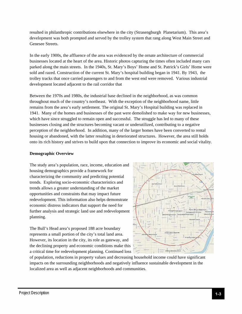
resulted in philanthropic contributions elsewhere in the city (Strasengburgh Planetarium). This area’s development was both prompted and served by the trolley system that rang along West Main Street and Genesee Streets. In the early 1900s, the affluence of the area was evidenced by the ornate architecture of commercial businesses located at the heart of the area. Historic photos capturing the times often included many cars parked along the main streets. In the 1940s, St. Mary’s Boys’ Home and St. Patrick’s Girls’ Home were sold and razed. Construction of the current St. Mary’s hospital building began in 1941. By 1943, the trolley tracks that once carried passengers to and from the west end were removed. Various industrial development located adjacent to the rail corridor that Between the 1970s and 1980s, the industrial base declined in the neighborhood, as was common throughout much of the country’s northeast. With the exception of the neighborhood name, little remains from the area’s early settlement. The original St. Mary’s Hospital building was replaced in 1941. Many of the homes and businesses of the past were demolished to make way for new businesses, which have since struggled to remain open and successful. The struggle has led to many of these businesses closing and the structures becoming vacant or underutilized, contributing to a negative perception of the neighborhood. In addition, many of the larger homes have been converted to rental housing or abandoned, with the latter resulting in deteriorated structures. However, the area still holds onto its rich history and strives to build upon that connection to improve its economic and social vitality. Demographic Overview The study area’s population, race, income, education and housing demographics provide a framework for characterizing the community and predicting potential trends. Exploring socio-economic characteristics and trends allows a greater understanding of the market opportunities and constraints that may impact future redevelopment. This information also helps demonstrate economic distress indicators that support the need for further analysis and strategic land use and redevelopment planning. The Bull’s Head area’s proposed 188 acre boundary represents a small portion of the city’s total land area. However, its location in the city, its role as gateway, and the declining property and economic conditions make this a critical time for redevelopment planning. Continued loss of population, reductions in property values and decreasing household income could have significant impacts on the surrounding neighborhoods and negatively influence sustainable development in the localized area as well as adjacent neighborhoods and communities.
1-4
Bull’s Head Neighborhood Pre-Nomination Study
During the pre-nomination planning efforts, initial demographic data were gathered to examine socio-economic trends in the Bull’s Head area and, where possible, compared with Rochester, Monroe County and the Rochester Metropolitan Statistical Area (Monroe, Orleans, Livingston, Ontario and Wayne counties) to provide greater context of the Bull’s Head area and the overall regional dynamics. It is important to note that the original data collection occurred before the 2010 Census data were available. That original assessment showed declining population in the Bull’s Head area. Based on 2008 projections, housing in Bull’s Head was projected to decrease as well, albeit at a low rate, while the city and County would likely see some gains projected out to 2013. Home-ownership in Bull’s Head had shown an increase since 1990 and was expected to continue up to 2013. However, that observed increase, and the project future increase, was likely due to the decrease in housing stock and not necessarily a reflection of increased home buying in the area. The owner-occupied rate for Bull’s Head, which was approximately 37 percent at the time of data collection, was still significantly lower than the national average of 68 percent. Household income in the Bull’s Head area was the lowest compared to the city and Monroe County, with more than half of all households earning less than $35,000. To determine whether socio-economic demographic trends had changed significantly since the 2010 Census Data had been released, Nielson data derived from 2010 Census figures was pulled for the Bull’s Head area (1-mile radius from the PBOA center) and the City of Rochester. The conditions uncovered in 2008 and 2009 had not changed significantly. In fact, economic conditions were more bleak than the projections that were based on 2000 data. The specified indicators of economic distress, such as low resident incomes, high poverty levels, high unemployment and high vacancy rates are exhibited in the PBOA boundary. Across every metric, the PBOA is below city and statewide averages. For the purposes of data collection, socio-economic information was obtained for a one-mile radius around the PBOA’s geographic center point and compared to citywide data. The comparison emphasizes the depressed economic conditions present in this area. For example, estimated Per Capita income for this area in 2011 was $12,551, compared to $16,691 per capita citywide. Fifty three percent of the population in the general PBOA area have an estimated house hold income of $24,999 (2011), compared to 44 percent citywide. The concentration of economic distress is also evidenced by the deteriorating physical conditions, especially at the center of the PBOA boundary. Disinvestment, blighted properties, vacant lots and demolition are correlated with declining property values. The concentration of poverty and the depressed property values have hindered redevelopment opportunities.
PROJECT OVERVIEW AND DESCRIPTION The Bull’s Head PBOA presents a pivotal opportunity to address the social, environmental and economic conditions that have hindered sustainable development in and around one of Rochester’s prominent western gateways. Portions of the area and/or specific sites have been the focus of planning and analysis over recent years. The most recent planning efforts included documentation of existing conditions and future land use planning for a 104 parcel sub-area within the boundary. As part of that
Project Description
1-5
effort, an environmental screening was completed, which identified more than 50 percent of the properties as known or potential environmental areas of concern, which will require further environmental investigation. The following list represents some of the more relevant studies and assessments related to the PBOA. These documents are available on the City of Rochester’s website (www.cityofrochester.gov) or at Rochester City Hall: Bull’s Head Neighborhood Design Workshop Summary Report Conditions Analysis Report for the Bull’s Head Redevelopment Area* Environmental Screen Report for Bull’s Head Area * Draft Generic Environmental Impact Statement St. Mary’s Hospital / Bull’s Head Plan Southwest Quadrant Strategic Plan Summary of Environmental Work Performed at the Former Taylor Instruments site (95 Ames
Street) Phase 1 and Phase 2 Environmental Assessment Report for 95 Ames Street Jefferson Avenue Concept Plan and Summary Report Brooks Landing Phase I and Phase II (* Pertains only to the sub-area) The information available via various planning efforts and studies ranges significantly in terms of specificity, consistency and relevancy (e.g. outdated). The PBOA Nomination will allow the City to leverage past planning work as it engages in a collaborative planning process to address the physical, environmental, social and economic opportunities and constraints facing this larger area. In addition to addressing the physical conditions of property condition, connectivity and public space, a Nomination study will provide important opportunities to identify strategies to preserve and celebrate this area’s rich history and cultural significance and reverse the downward trends that have resulted from disinvestment, physical degradation and economic despair.
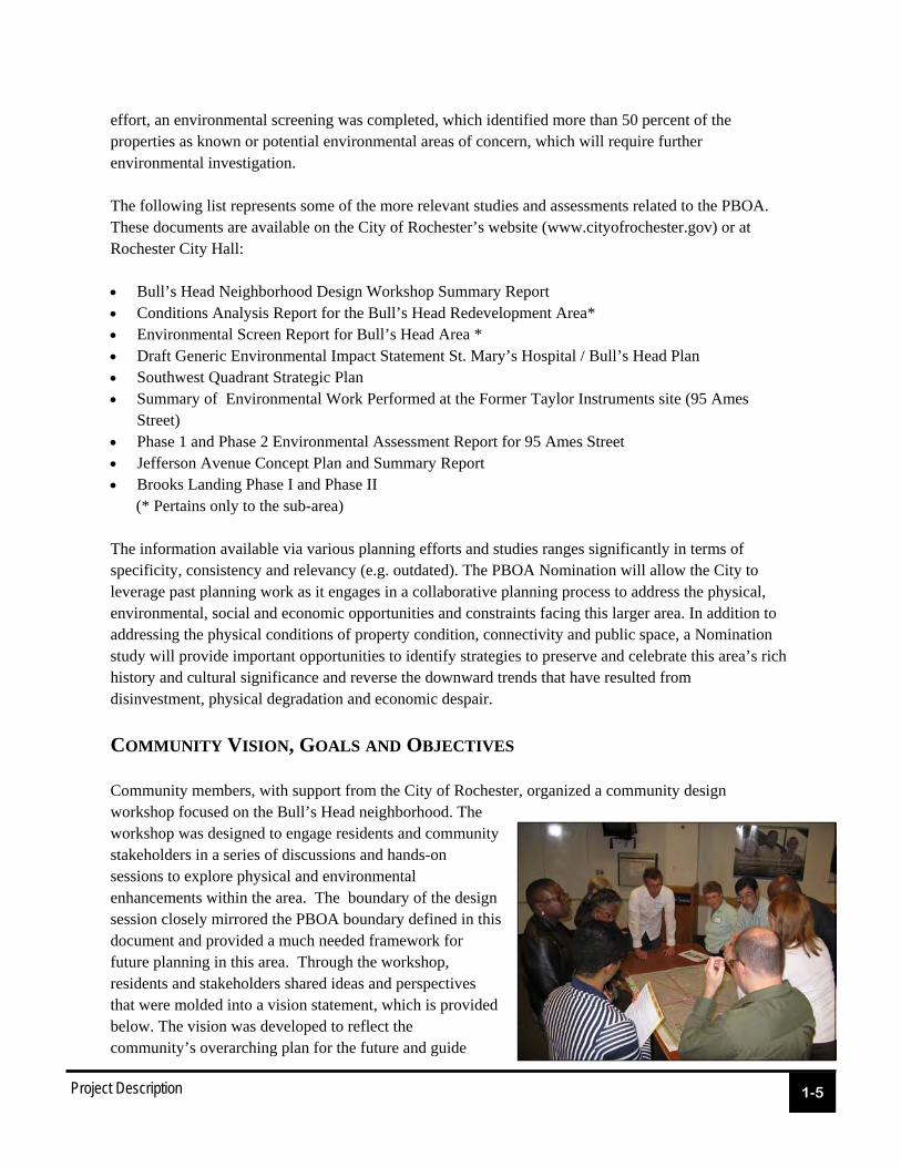
COMMUNITY VISION, GOALS AND OBJECTIVES Community members, with support from the City of Rochester, organized a community design workshop focused on the Bull’s Head neighborhood. The workshop was designed to engage residents and community stakeholders in a series of discussions and hands-on sessions to explore physical and environmental enhancements within the area. The boundary of the design session closely mirrored the PBOA boundary defined in this document and provided a much needed framework for future planning in this area. Through the workshop, residents and stakeholders shared ideas and perspectives that were molded into a vision statement, which is provided below. The vision was developed to reflect the community’s overarching plan for the future and guide

1-6
Bull’s Head Neighborhood Pre-Nomination Study
subsequent policies and decision making. The vision outlines a general blueprint by which future neighborhood enhancement and progress can be achieved. The goals outlined in the following section focus on the specific issues, topics or challenges within the larger vision that will need to be addressed in greater detail. The vision and goals identified for the PBOA are consistent with the Renaissance Campaigns of the city’s Rochester comprehensive plan, adopted by City Council on April 13, 1999. The relevant campaign goals are summarized below: - Campaign One: Involved Citizens – “Citizens, institutions and businesses will be encouraged to participate in events, activities, and celebrations that serve to ‘knit’ our community together and that are focused on the positive aspects of our community. - Campaign Three: Health, Safety and Responsibility – “Promote neighborhoods that are safe, clean and attractive, that minimize drug sales and use, loitering, graffiti, public drunkenness, property code violations, incidents of fires and other negative quality of life issues and that ultimately reduce the demand for public safety services.” - Campaign Four: Environmental Stewardship – “Reduce the amounts and toxicity of the various forms of pollution entering our environment and the public health threats from all forms of environmental pollution and contaminants.”, “Preserve and enhance our waterways, parks, urban forest, recreation and open space areas through a regional ‘no-net-loss’ approach and maximized environmental benefits
The Bull’s Head Physical Redevelopment Area will establish an
attractive western gateway, improve the area’s appearance and
character, reflect Bull’s Head’s history, and encourage public and
private investment over time. Physical redevelopment will define the
area’s focal point and enhance its visual quality through attractive
landscaping and streetscaping and well-designed sidewalks, buildings
and public spaces. Future enhancements will promote positive social
and economic development and encourage high-quality construction
and long-term sustainability. Ultimately, the area’s redevelopment will
expand business opportunities, provide critical public services and
support a diverse residential population for many years to come.

Project Description
1-7
derived from those resources and assets.”; and, “Reclaim designated ‘brownfields’ and other contaminated land, facilities, and water-ways for useful, productive development.” - Campaign Six: Economic Vitality – “Develop strong, economically viable and diverse neighborhood commercial areas that help to provide entry-level jobs, high-quality goods and personal services to our citizens, offer entrepreneurial opportunities and help increase our city’s economic development and growth.” - Campaign Seven: Quality Service – “Provide a parks and recreation system and program that meet our citizens’ needs and demands and expands and safeguards our urban forest.” - Campaign Eight: Tourism Destination – Transform our extensive and unique waterfront resources, historic and cultural assets into a regional tourism destination attraction that maximizes economic, environmental and recreational benefits in a way that enhances the quality of life for city residents.” - Campaign Nine: Healthy Urban Neighborhoods – “Reduce the impacts of the concentrations of poverty in our community by encouraging economic diversity, appropriate neighborhood design and planning and expanded economic opportunity.”; “Develop a pedestrian circulation system that provides maximum accessibility to nearby goods and services, our parks, recreation and open space areas and other community amenities.”; and, “Support a land use development pattern in our city that balances reasonable property use right with our community’s expectation of protection from negative impacts generated by nearby uses or activities.” These goals identified in the City’s comprehensive plan coincide with the visions and goals identified by the community. Neighborhood Goals Despite the current physical conditions of the neighborhood, the City and community see a unique opportunity for revitalizing Bull’s Head. The Bull’s Head neighborhood still remains a prominent gateway into the city, with the convergence of four minor arterials—West Main Street, Chili Avenue (Route 33A), West Avenue (Route 33), and Genesee Street—along with Brown Street, a local collector in the city. In addition to community desire to restore the neighborhood, the area also presents opportunities for public and private investment in existing institutions (e.g. St. Mary’s Hospital) and potential future civic spaces (e.g. a new west side police station). In general, the goals of the area include:
Identify opportunities for improving land use and economic development
Address aesthetic character in both the public and private realm
Develop conceptual development schemes for sub-areas within the boundary that identify prime locations for public and private investment.

1-8
Bull’s Head Neighborhood Pre-Nomination Study
Promote the neighborhood’s local history and importance in Rochester
Consider the establishment of an urban renewal district for the area to provide a means for revitalization
Build community support, enthusiasm, and commitment to continue to drive the revitalization and redevelopment with the City and private developers
Prioritize remediation of environmentally challenged sites and initiate planning and execution of future remediation.
BROWNFIELD OPPORTUNTIY AREA BOUNDARY DESCRIPTION AND JUSTIFICATION The PBOA contains a significant concentration of parcels and structures that are vacant, underutilized or have known or potential environmental contaminants. The environmental conditions within the proposed boundary have been examined to varying degrees over the last two decades. In 1993, a Draft Environmental Impact Statement was prepared for the St. Mary’s Hospital /Bull’s Head Development Plan. A copy of that report is on file at the City of Rochester and can be accessed at City Hall, Department of Environmental Services. Extensive environmental review (including a Phase I and Phase II Analysis) of 95 Ames Street has been conducted, along with minimal voluntary site clean up. The site, a former manufacturing facility, has extensive, well document contamination on site that has hindered redevelopment. Except for the 95 Ames site and a few other small parcels with known environmental hazards, conditions analysis within the project area has not included inspections of building interiors or
Project Description
1-9
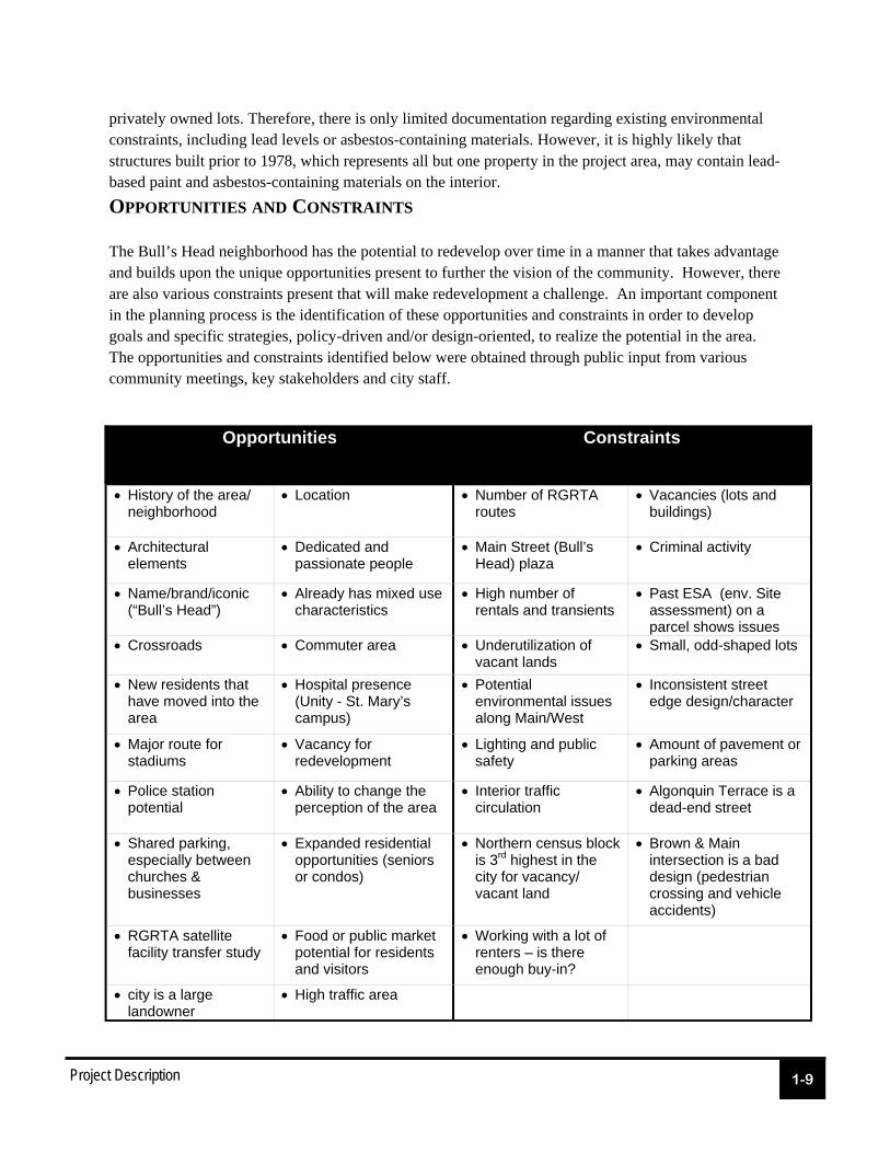
Opportunities Constraints
History of the area/ neighborhood
Location Number of RGRTA routes
Vacancies (lots and buildings)
Architectural elements
Dedicated and passionate people
Main Street (Bull’s Head) plaza
Criminal activity
Name/brand/iconic (“Bull’s Head”)
Already has mixed use characteristics
High number of rentals and transients
Past ESA (env. Site assessment) on a parcel shows issues
Crossroads Commuter area Underutilization of vacant lands
Small, odd-shaped lots
New residents that have moved into the area
Hospital presence (Unity - St. Mary’s campus)
Potential environmental issues along Main/West
Inconsistent street edge design/character
Major route for stadiums
Vacancy for redevelopment
Lighting and public safety
Amount of pavement or parking areas
Police station potential
Ability to change the perception of the area
Interior traffic circulation
Algonquin Terrace is a dead-end street
Shared parking, especially between churches & businesses
Expanded residential opportunities (seniors or condos)
Northern census block is 3rd highest in the city for vacancy/vacant land
Brown & Main intersection is a bad design (pedestrian crossing and vehicle accidents)
RGRTA satellite facility transfer study
Food or public market potential for residents and visitors
Working with a lot of renters – is there enough buy-in?
city is a large landowner
High traffic area
privately owned lots. Therefore, there is only limited documentation regarding existing environmental constraints, including lead levels or asbestos-containing materials. However, it is highly likely that structures built prior to 1978, which represents all but one property in the project area, may contain lead-based paint and asbestos-containing materials on the interior.
OPPORTUNITIES AND CONSTRAINTS The Bull’s Head neighborhood has the potential to redevelop over time in a manner that takes advantage and builds upon the unique opportunities present to further the vision of the community. However, there are also various constraints present that will make redevelopment a challenge. An important component in the planning process is the identification of these opportunities and constraints in order to develop goals and specific strategies, policy-driven and/or design-oriented, to realize the potential in the area. The opportunities and constraints identified below were obtained through public input from various community meetings, key stakeholders and city staff.
City of Rochester Clark Patterson Lee
Bull’s Head Neighborhood Pre-Nomination Study
- Section 2 -
Preliminary Analysis of the Brownfield Area
Preliminary Analysis
2-1
EXISTING LAND USE AND ZONING
Land Use
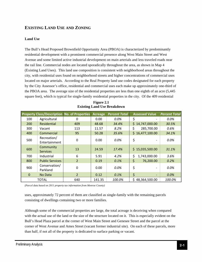
The Bull’s Head Proposed Brownfield Opportunity Area (PBOA) is characterized by predominantly
residential development with a prominent commercial presence along West Main Street and West
Avenue and some limited active industrial development on main arterials and less traveled roads near
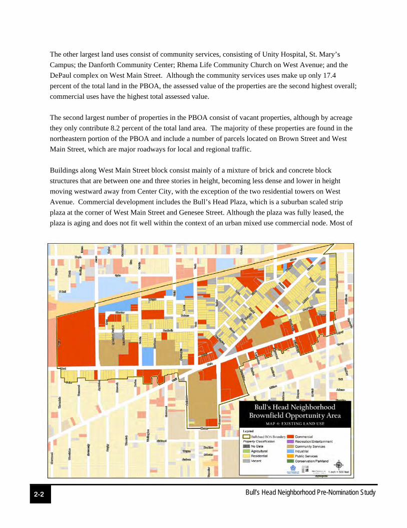
the rail line. Commercial nodes are located sporadically throughout the area, as shown in Map 4
(Existing Land Uses). This land use composition is consistent with neighborhood areas throughout the
city, with residential uses found on neighborhood streets and higher concentrations of commercial uses
located on major arterials. According to the Real Property land use codes designated for each property
by the City Assessor’s office, residential and commercial uses each make up approximately one-third of
the PBOA area. The average size of the residential properties are less than one eighth of an acre (5,445
square feet), which is typical for single-family residential properties in the city. Of the 409 residential
uses, approximately 72 percent of them are classified as single-family with the remaining parcels
consisting of dwellings containing two or more families.
Although some of the commercial properties are large, the total acreage is deceiving when compared
with the actual use of the land or the size of the structure located on it. This is especially evident on the
Bull’s Head Plaza parcel at the corner of West Main Street and Genesee Street and the parcel at the
corner of West Avenue and Ames Street (vacant former industrial site). On each of these parcels, more
than half, if not all of the property is dedicated to surface parking or vacant.
Figure 2.1 Existing Land Use Breakdown
(Parcel data based on 2011 property tax information from Monroe County)
Property Class/Description No. of Properties Acreage Percent Total Assessed Value Percent Total
100 Agricultural 0 0.00 0.0% $ ‐ 0.0%
200 Residential 409 48.68 34.4% $ 14,747,000.00 30.5%
300 Vacant 113 11.57 8.2% $ 285,700.00 0.6%
400 Commercial 95 50.28 35.6% $ 16,477,100.00 34.1%
500 Recreation/Entertainment
0 0.00 0.0% $ ‐ 0.0%
600 Community Services
13 24.59 17.4% $ 15,035,500.00 31.1%
700 Industrial 6 5.91 4.2% $ 1,743,000.00 3.6%
800 Public Services 2 0.19 0.1% $ 76,200.00 0.2%
900 Conservation/Parkland
0 0.00 0.0% $ ‐ 0.0%
0 No Data 2 0.12 0.1% $ ‐ 0.0%
TOTAL 640 141.35 100.0% $ 48,364,500.00 100.0%
2-2
Bull’s Head Neighborhood Pre-Nomination Study
The other largest land uses consist of community services, consisting of Unity Hospital, St. Mary’s
Campus; the Danforth Community Center; Rhema Life Community Church on West Avenue; and the
DePaul complex on West Main Street. Although the community services uses make up only 17.4
percent of the total land in the PBOA, the assessed value of the properties are the second highest overall;
commercial uses have the highest total assessed value.
The second largest number of properties in the PBOA consist of vacant properties, although by acreage
they only contribute 8.2 percent of the total land area. The majority of these properties are found in the
northeastern portion of the PBOA and include a number of parcels located on Brown Street and West
Main Street, which are major roadways for local and regional traffic.
Buildings along West Main Street block consist mainly of a mixture of brick and concrete block
structures that are between one and three stories in height, becoming less dense and lower in height
moving westward away from Center City, with the exception of the two residential towers on West
Avenue. Commercial development includes the Bull’s Head Plaza, which is a suburban scaled strip
plaza at the corner of West Main Street and Genesee Street. Although the plaza was fully leased, the
plaza is aging and does not fit well within the context of an urban mixed use commercial node. Most of
Preliminary Analysis
2-3
the other commercial buildings in the area are built at or close to the property line and contiguous to one
another. For the most part, many of the newer structures are easily discernible as they are built with
greater setbacks at the front and side. Full width sidewalks are found throughout the area, connecting
the commercial areas to residential areas on the outskirts. The commercial buildings along West Main
Street exhibit various design styles - some with more ornate architectural features - as well as in various
conditions.
The housing stock that makes up the remainder of the PBOA varies by construction, ownership/
occupation, and condition. The vast majority of the residential properties have a tree lawn, sidewalk,
and front yard with street trees located on the backside of the sidewalks. The residents who have made
upgrades and enhancements to their individual homes and properties easily stand out among other
properties, with new or maintained siding and trim, landscaped yards, and generally maintained lawns.
Of the structures in the PBOA, approximately 419 of them were constructed before World War 2 - 168
of them built prior to 1900. Only 27 were built within the past decade. Although the ages of many of
the structures may contribute to a historical preservation aspect in the area, the use of modern building
materials and methods may have significantly altered any architectural or historical features that relate to
the original buildings.
Surrounding Area
The uses surrounding Bull’s Head mirror those found within the neighborhood with commercial uses
primarily along main thoroughfares and residential dwellings located on the periphery. Farther north
and west of the area, larger commercial and industrial uses are found, taking advantage of both rail and
interstate access. Commercial uses become more prominent moving eastward along West Main Street
approaching Rochester’s Center City.
More recent developments in and around the area, including Susan B. Anthony neighborhood/West
Main Street improvement project, Jefferson Avenue Reconstruction and Brooks Landing Phases 1 and 2,
reflect the rebirth and reinvestment taking place in the City’s southwest quadrant. These projects have
resulted in improved physical aesthetics, increased availability of goods and services, enhanced
pedestrian and bicycle amenities, all of which has increased the community’s collective motivation to
continue its redevelopment efforts.
Zoning
The PBOA is split up into six zoning districts as shown in Map 5 (Existing Zoning): community center
(C-2), low-density residential (R-1), medium-density residential (R-2), open space (O-S), industrial (M-
1) and an institutional planned development district (IPD #10). The community center district, located
along West Main Street, Brown Street and West Avenue, is intended to provide a diverse mix of
commercial and residential uses along major corridors and in neighborhood centers. The commercial
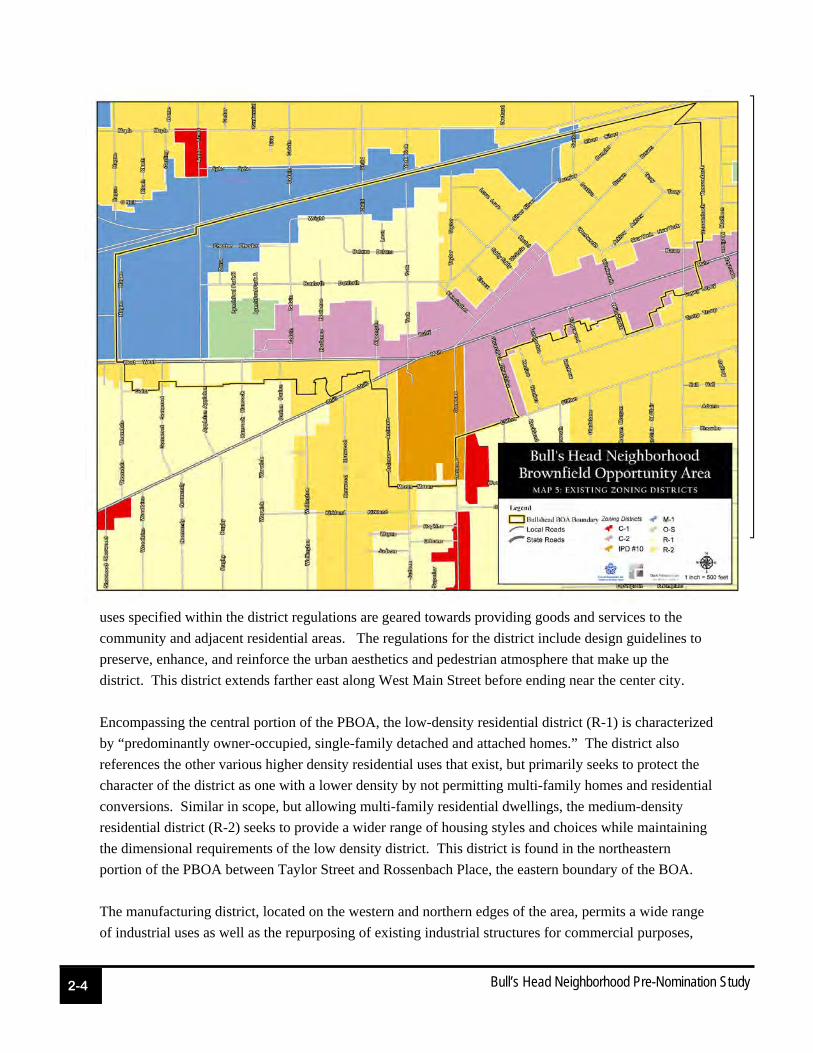
2-4
Bull’s Head Neighborhood Pre-Nomination Study
uses specified within the district regulations are geared towards providing goods and services to the
community and adjacent residential areas. The regulations for the district include design guidelines to
preserve, enhance, and reinforce the urban aesthetics and pedestrian atmosphere that make up the
district. This district extends farther east along West Main Street before ending near the center city.
Encompassing the central portion of the PBOA, the low-density residential district (R-1) is characterized
by “predominantly owner-occupied, single-family detached and attached homes.” The district also
references the other various higher density residential uses that exist, but primarily seeks to protect the
character of the district as one with a lower density by not permitting multi-family homes and residential
conversions. Similar in scope, but allowing multi-family residential dwellings, the medium-density
residential district (R-2) seeks to provide a wider range of housing styles and choices while maintaining
the dimensional requirements of the low density district. This district is found in the northeastern
portion of the PBOA between Taylor Street and Rossenbach Place, the eastern boundary of the BOA.
The manufacturing district, located on the western and northern edges of the area, permits a wide range
of industrial uses as well as the repurposing of existing industrial structures for commercial purposes,

Preliminary Analysis
2-5
with some uses limited to only a specific percentage of the total floor area. The variety of industrial uses
that are permitted must have activities that are fully located within an enclosed structure. Similar to
other districts in the city, the manufacturing district also includes design guidelines and standards to
preserve, enhance, and reinforce the character and aesthetics of the district. The manufacturing district
extends further north and west from the PBOA along the CSX railline, encompassing the a large section
of the west side of Rochester.
The intent of the open space (O-S) district is “...preserve and enhance Rochester’s open spaces and
recreational areas … [by] strictly limiting the development of these areas.” Permitted uses in the district
are centered around recreational and cultural resources, such as parks, open areas, gardens, cemeteries
and public marinas. Within the PBOA, the only area zoned as open space is the open field and lands of
the Danforth Community Center on West Avenue. Open space districts are also classified as critical
environmental areas (CEA) in Monroe County according to the NYS Department of Environmental
Conservation, which makes these lands subject to closer examination for any environmental reviews.
Transportation Network
The relationship between land use, development and transportation systems is symbiotic, in that changes
to one element often impact conditions and needs of the other. Public infrastructure improvements, such
as streetscape enhancements, can serve as a catalyst for profound improvements in community
development and private investment. Thinking about future redevelopment in the Bull’s Head areawill
require a careful consideration of the existing transportation network and identification of modifications
that will enhance the transportation network’s design, performance and ability to sustain redevelopment
over time.
The PBOA is serviced by three primary arterials, West Main Street, West Avenue and Chili Avenue.
West Avenue carries four lanes of traffic.
West Main Street is comprised of five travel
lanes, which includes a dedicated turn lane at
the intersection with West Avenue and Brown
Street. On-street parking is allowed on West
Main only on the north side between York
Street and Brown Street for the various
commercial properties located there.
West Main Street and West Avenue, along
with Chili Avenue, serve as a major east-west
connectors for residents in the west and
southwest neighborhoods of the city and
2-6
Bull’s Head Neighborhood Pre-Nomination Study
neighboring towns. Chili Avenue is a two-lane street that has a wide shoulder that can be utilized for on-
street parking on both sides. Brown Street, similar to Chili Avenue, is a two-lane street with a wide
shoulder on both sides of the street that allows limited on-street parking. These corridors function as
gateways to the Rochester’s city Center and historic neighborhoods (e.g. Susan B. Anthony).
The remaining streets are two-lane residential streets that have varying right-of-way width to
accommodate on-street parking. However, the current configuration controls speeds through the
residential streets.
The project area features a generally well connected street grid. However, there is one dead end street
(Algonquin Terrace). The residential side streets had lower volumes of traffic and no noticeable issues.
All of these streets were controlled by stop signs.
Traffic conditions in the PBOA have been the focus of past and recent studies, given the challenging
five point intersections at the heart of the project area and the high volumes that utilize West Main
Street, West Avenue and Chili Avenue. The short distance (less than 400 LF) between the intersection
of West Main, Brown & Genesee and West Avenue, York Street, Chili Avenue & West Main also
makes this intersection’s geometry atypical and challenging. Pedestrian access at these intersections is a
challenge due to traffic volumes, turning movements and crossing widths All of these major
intersections are controlled by traffic signals with dedicated turning lanes utilizing signalized turning
arrows.
A recent traffic study was conducted in March 2011 to examine conditions at the two primary
intersections as well as existing and future conditions of nearby streets. The study was prepared to
document potential traffic impacts associated with redevelopment scenarios being considered in the sub-
area. However, that traffic analysis would need to be expanded to include all of the major intersections
with the PBOA to fully understand transportation system opportunities and constraints. Future study
would also need to formally document pedestrian and bicycle access and safety, which is suspected to be
challenged in this area due to lack of adequate facilities and challenging roadway geometry.
RGRTA maintains five bus routes through the PBOA, including routes 2, 4, 8, 12 and 27. The
neighborhood and surrounding area have a complete network of sidewalks that connect all residential
and commercial uses. The sidewalks are located on both sides of the streets, but crosswalks are limited
only to the West Main Street-West Avenue-Chili Avenue area.
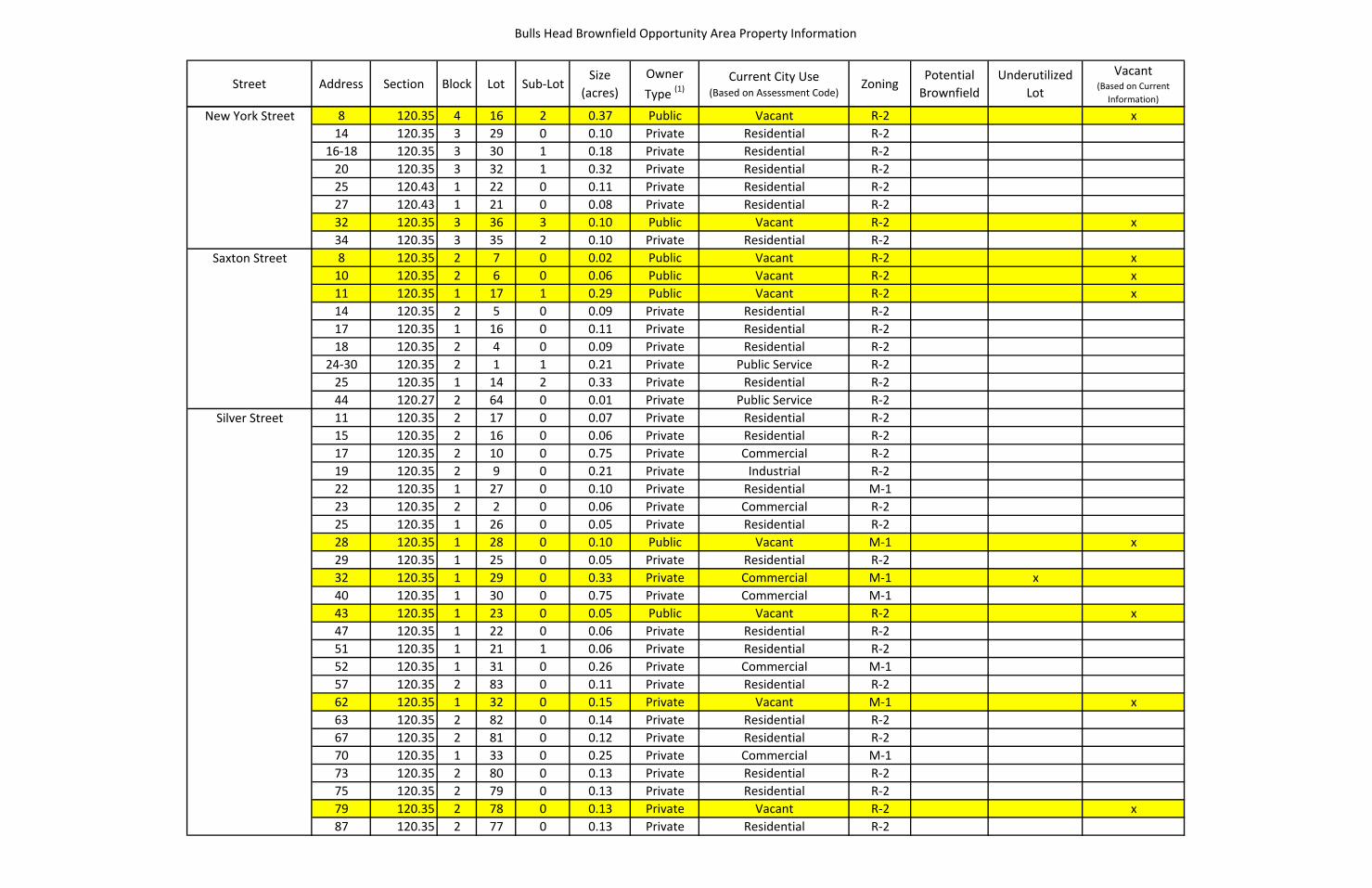
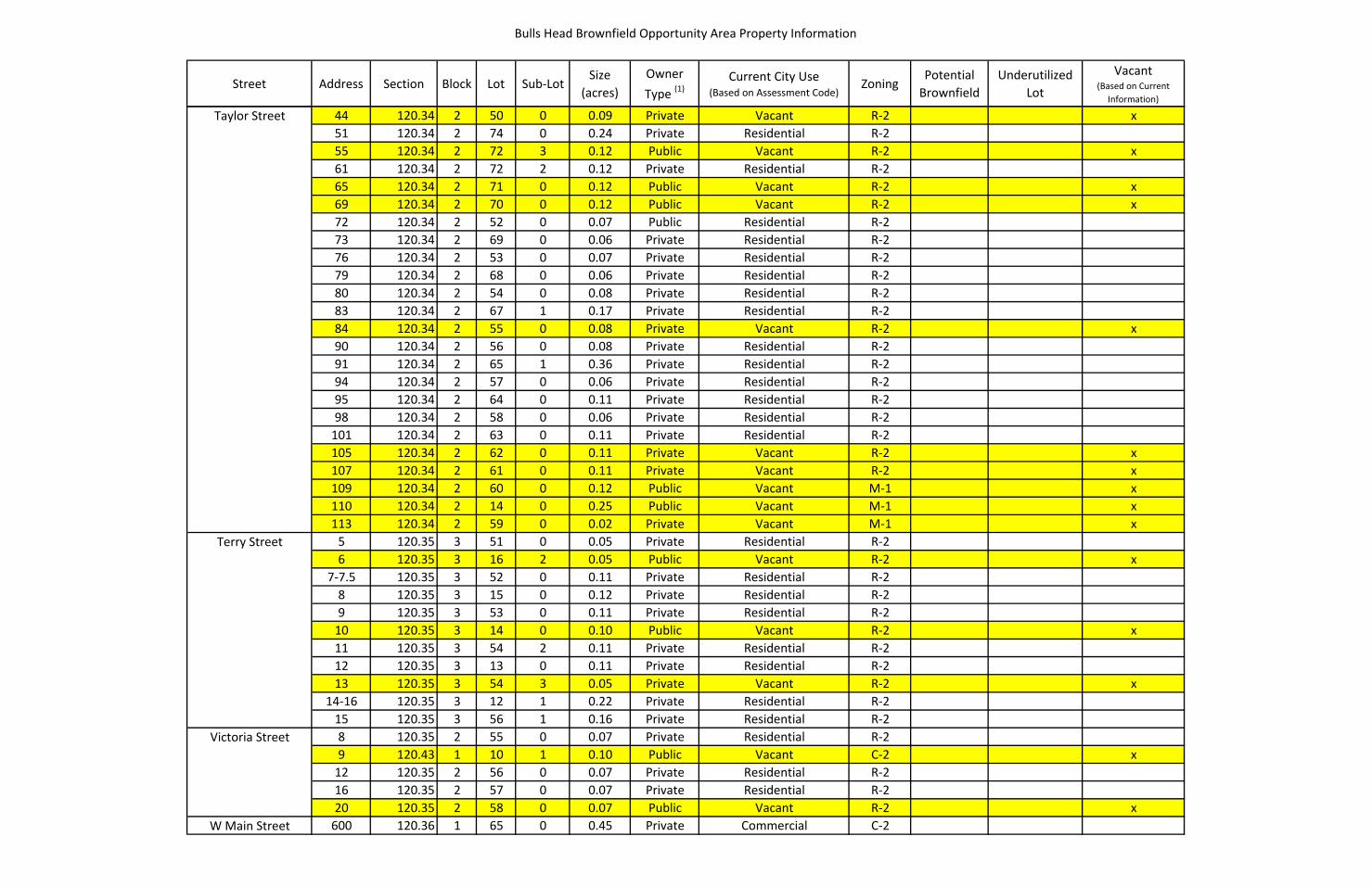
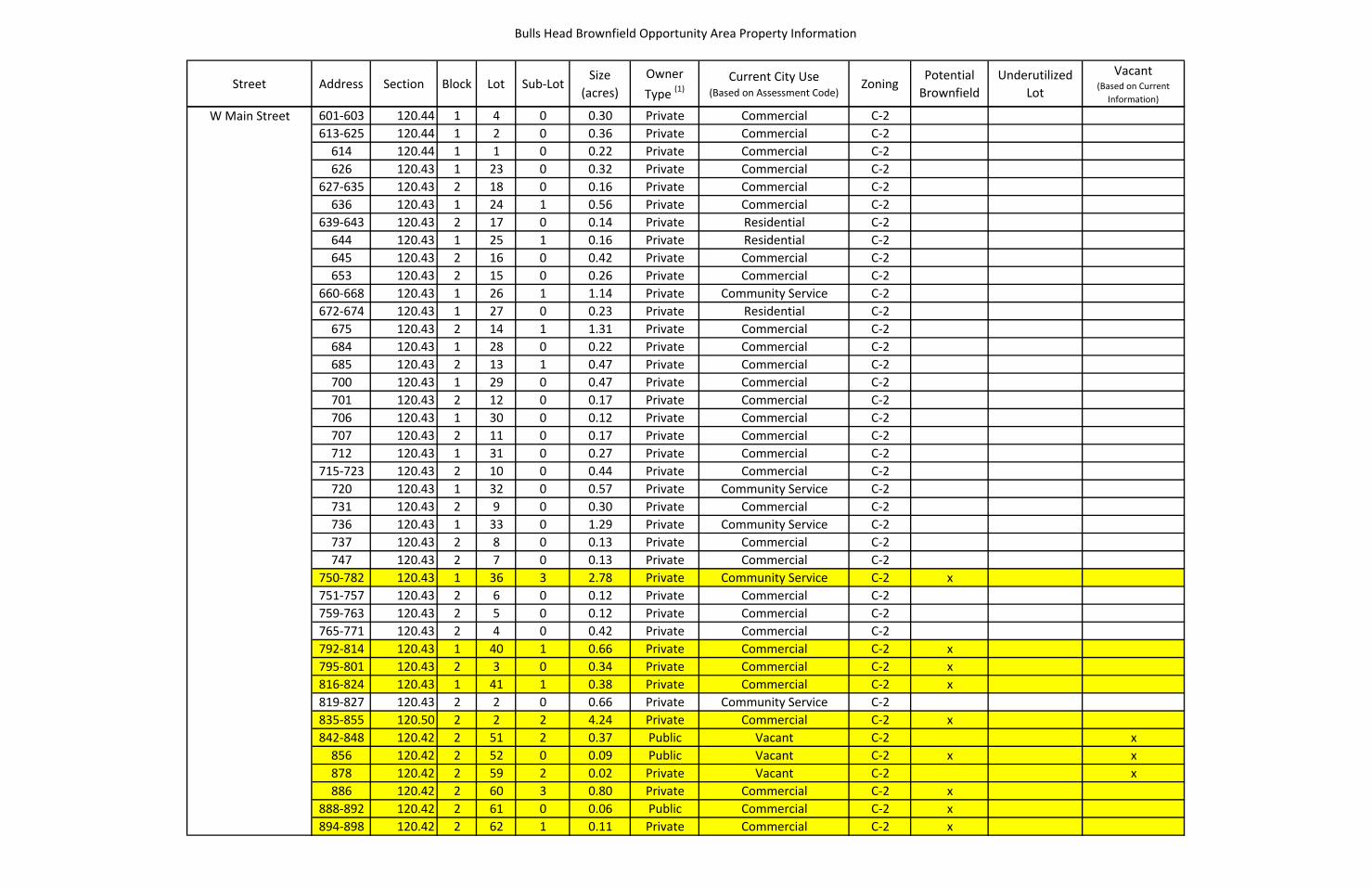
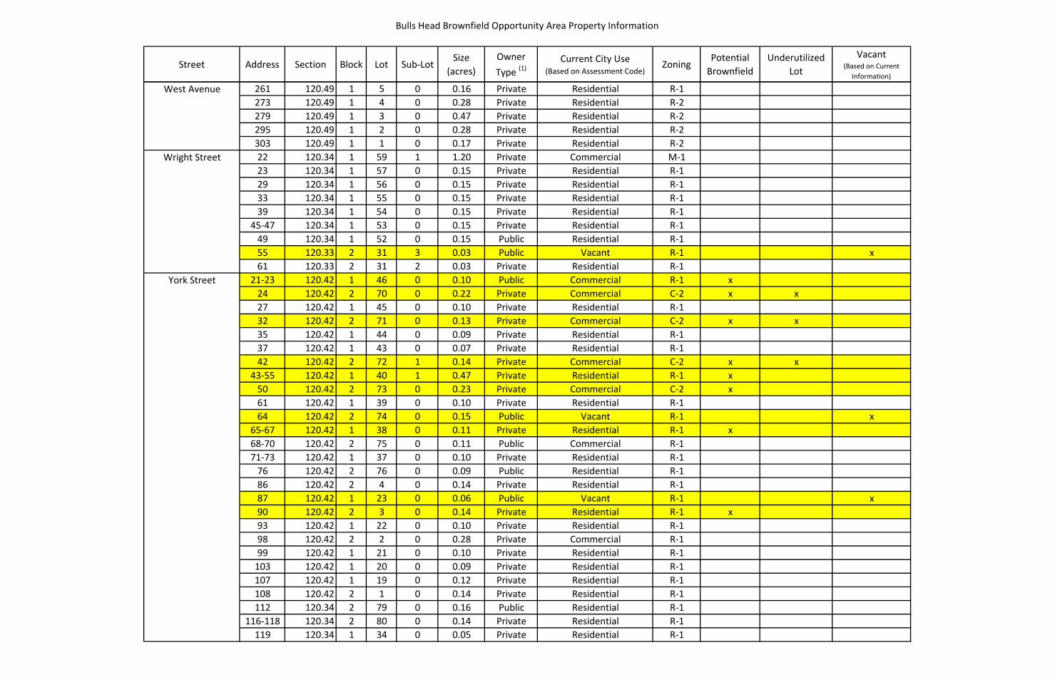
BROWNFIELD, ABANDONED AND VACANT SITES
The proposed boundary is comprised of a high percentage of underutilized, vacant and brownfield sites,
which are provided on the following table. This table and accompanying map were developed based on

Preliminary Analysis 2-7
past environmental screenings and/or city staff’s knowledge of known or suspected environmental
hazards.
For many properties within the PBOA, the known/suspected environmental issues are related to the presence of potential harmful contaminants associated with historic building materials (e.g. asbestos and lead) . Some properties’ current or past industrial or commercial uses may present some hazardous environmental conditions that may need to be addressed as part of any redevelopment. The sub-surface conditions in the project area largely undocumented and will likely need further investigation prior to redevelopment. The environmental conditions associated with auto-repair shop on York Street and the light industrial facility on West Avenue (between Hortense and Colvin Streets) will also need to be examined. 95 Ames Street presents the most serious environmental hazards, which have been well documented in previous assessments. The future redevelopment of that site will be limited significantly to avoid disturbance of contaminated (and capped) soils and minimize impacts to human health.
The table provided on the following pages includes all properties located within in the PBOA boundary. The properties highlighted in yellow include vacant, underutilized and/or potential brownfield sites.

This page has been left blank intentionally.
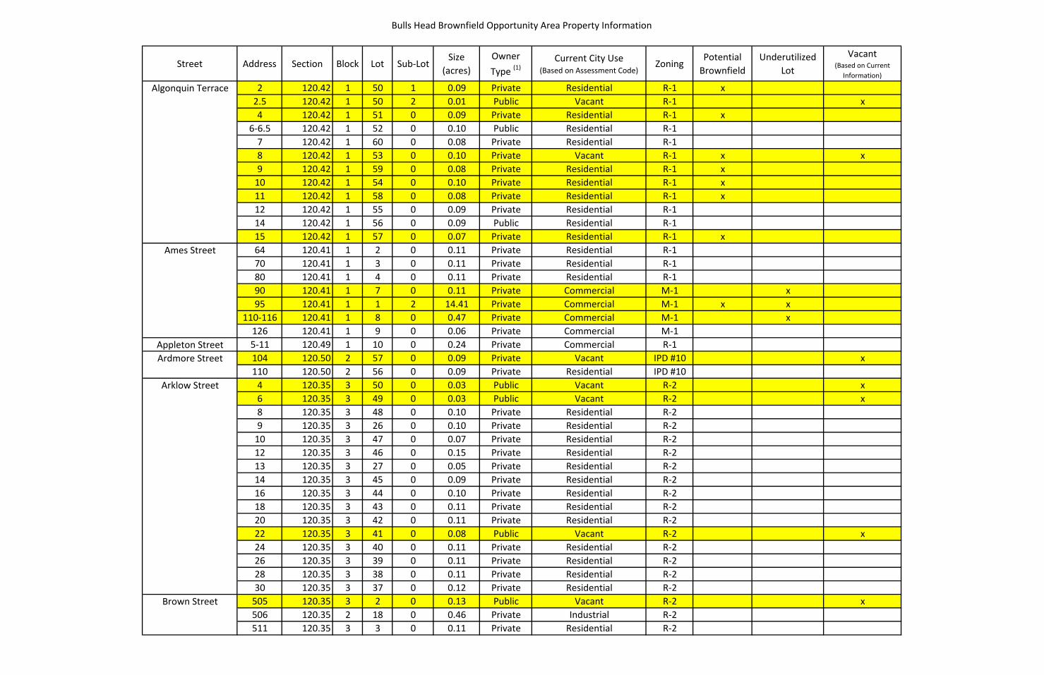
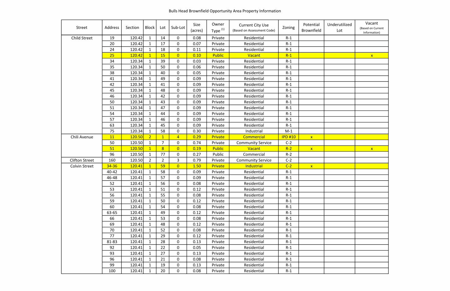
Bulls Head Brownfield Opportunity Area Property Information
Street Address Section Block Lot Sub-LotSize
(acres)Owner Type (1)
Current City Use (Based on Assessment Code)
ZoningPotential
BrownfieldUnderutilized
Lot
Vacant (Based on Current
Information)
Algonquin Terrace 2 120.42 1 50 1 0.09 Private Residential R-1 x2.5 120.42 1 50 2 0.01 Public Vacant R-1 x4 120.42 1 51 0 0.09 Private Residential R-1 x
6-6.5 120.42 1 52 0 0.10 Public Residential R-17 120.42 1 60 0 0.08 Private Residential R-18 120.42 1 53 0 0.10 Private Vacant R-1 x x9 120.42 1 59 0 0.08 Private Residential R-1 x
10 120.42 1 54 0 0.10 Private Residential R-1 x11 120.42 1 58 0 0.08 Private Residential R-1 x12 120.42 1 55 0 0.09 Private Residential R-114 120.42 1 56 0 0.09 Public Residential R-115 120.42 1 57 0 0.07 Private Residential R-1 x
Ames Street 64 120.41 1 2 0 0.11 Private Residential R-170 120.41 1 3 0 0.11 Private Residential R-180 120.41 1 4 0 0.11 Private Residential R-190 120.41 1 7 0 0.11 Private Commercial M-1 x95 120.41 1 1 2 14.41 Private Commercial M-1 x x
110-116 120.41 1 8 0 0.47 Private Commercial M-1 x126 120.41 1 9 0 0.06 Private Commercial M-1
Appleton Street 5-11 120.49 1 10 0 0.24 Private Commercial R-1Ardmore Street 104 120.50 2 57 0 0.09 Private Vacant IPD #10 x
110 120.50 2 56 0 0.09 Private Residential IPD #10Arklow Street 4 120.35 3 50 0 0.03 Public Vacant R-2 x
6 120.35 3 49 0 0.03 Public Vacant R-2 x8 120.35 3 48 0 0.10 Private Residential R-29 120.35 3 26 0 0.10 Private Residential R-2
10 120.35 3 47 0 0.07 Private Residential R-212 120.35 3 46 0 0.15 Private Residential R-213 120.35 3 27 0 0.05 Private Residential R-214 120.35 3 45 0 0.09 Private Residential R-216 120.35 3 44 0 0.10 Private Residential R-218 120.35 3 43 0 0.11 Private Residential R-220 120.35 3 42 0 0.11 Private Residential R-222 120.35 3 41 0 0.08 Public Vacant R-2 x24 120.35 3 40 0 0.11 Private Residential R-226 120.35 3 39 0 0.11 Private Residential R-228 120.35 3 38 0 0.11 Private Residential R-230 120.35 3 37 0 0.12 Private Residential R-2
Brown Street 505 120.35 3 2 0 0.13 Public Vacant R-2 x506 120.35 2 18 0 0.46 Private Industrial R-2511 120.35 3 3 0 0.11 Private Residential R-2
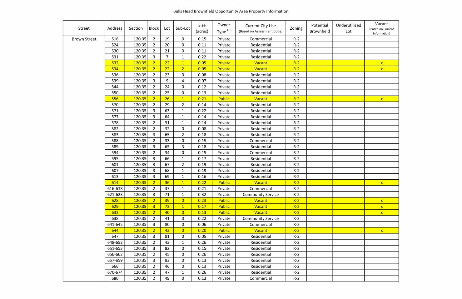
Bulls Head Brownfield Opportunity Area Property Information
Street Address Section Block Lot Sub-LotSize
(acres)Owner Type (1)
Current City Use (Based on Assessment Code)
ZoningPotential
BrownfieldUnderutilized
Lot
Vacant (Based on Current
Information)
Brown Street 516 120.35 2 19 0 0.15 Private Commercial R-2524 120.35 2 20 0 0.11 Private Residential R-2530 120.35 2 21 0 0.11 Private Residential R-2531 120.35 3 7 1 0.22 Private Residential R-2532 120.35 2 22 1 0.05 Private Vacant R-2 x534 120.35 2 22 2 0.05 Private Vacant R-2 x536 120.35 2 23 0 0.08 Private Residential R-2539 120.35 3 9 4 0.07 Private Residential R-2544 120.35 2 24 0 0.12 Private Residential R-2550 120.35 2 25 0 0.13 Private Residential R-2556 120.35 2 26 1 0.21 Public Vacant R-2 x570 120.35 2 29 2 0.14 Private Residential R-2571 120.35 3 63 1 0.22 Private Residential R-2577 120.35 3 64 1 0.14 Private Residential R-2578 120.35 2 31 1 0.14 Private Residential R-2582 120.35 2 32 0 0.08 Private Residential R-2583 120.35 3 65 2 0.18 Private Residential R-2588 120.35 2 33 0 0.15 Private Commercial R-2589 120.35 3 65 3 0.18 Private Residential R-2594 120.35 2 34 0 0.15 Private Commercial R-2595 120.35 3 66 1 0.17 Private Residential R-2601 120.35 3 67 2 0.19 Private Residential R-2607 120.35 3 68 1 0.19 Private Residential R-2613 120.35 3 69 1 0.16 Private Residential R-2614 120.35 2 36 1 0.22 Public Vacant R-2 x
616-618 120.35 2 37 1 0.21 Private Commercial R-2621-623 120.35 3 71 1 0.32 Private Community Service R-2
628 120.35 2 39 0 0.23 Public Vacant R-2 x629 120.35 3 72 1 0.17 Public Vacant R-2 x632 120.35 2 40 0 0.13 Public Vacant R-2 x638 120.35 2 41 0 0.22 Private Community Service R-2
641-645 120.35 3 80 0 0.06 Private Commercial R-2644 120.35 2 42 0 0.20 Public Vacant R-2 x647 120.35 3 81 0 0.05 Private Residential R-2
648-652 120.35 2 43 1 0.26 Private Residential R-2651-653 120.35 3 82 0 0.15 Private Residential R-2656-662 120.35 2 45 0 0.26 Private Residential R-2657-659 120.35 3 83 0 0.13 Private Residential R-2
666 120.35 2 46 0 0.13 Private Residential R-2670-674 120.35 2 47 1 0.26 Private Residential R-2
680 120.35 2 49 0 0.13 Private Commercial R-2
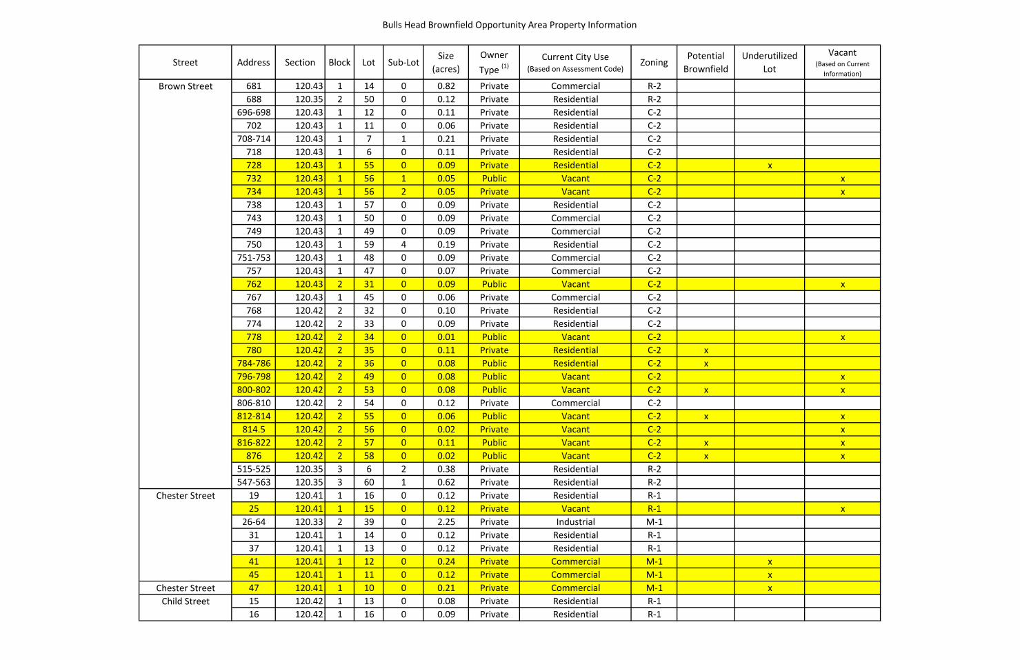
Bulls Head Brownfield Opportunity Area Property Information
Street Address Section Block Lot Sub-LotSize
(acres)Owner Type (1)
Current City Use (Based on Assessment Code)
ZoningPotential
BrownfieldUnderutilized
Lot
Vacant (Based on Current
Information)
Brown Street 681 120.43 1 14 0 0.82 Private Commercial R-2688 120.35 2 50 0 0.12 Private Residential R-2
696-698 120.43 1 12 0 0.11 Private Residential C-2702 120.43 1 11 0 0.06 Private Residential C-2
708-714 120.43 1 7 1 0.21 Private Residential C-2718 120.43 1 6 0 0.11 Private Residential C-2728 120.43 1 55 0 0.09 Private Residential C-2 x732 120.43 1 56 1 0.05 Public Vacant C-2 x734 120.43 1 56 2 0.05 Private Vacant C-2 x738 120.43 1 57 0 0.09 Private Residential C-2743 120.43 1 50 0 0.09 Private Commercial C-2749 120.43 1 49 0 0.09 Private Commercial C-2750 120.43 1 59 4 0.19 Private Residential C-2
751-753 120.43 1 48 0 0.09 Private Commercial C-2757 120.43 1 47 0 0.07 Private Commercial C-2762 120.43 2 31 0 0.09 Public Vacant C-2 x767 120.43 1 45 0 0.06 Private Commercial C-2768 120.42 2 32 0 0.10 Private Residential C-2774 120.42 2 33 0 0.09 Private Residential C-2778 120.42 2 34 0 0.01 Public Vacant C-2 x780 120.42 2 35 0 0.11 Private Residential C-2 x
784-786 120.42 2 36 0 0.08 Public Residential C-2 x796-798 120.42 2 49 0 0.08 Public Vacant C-2 x800-802 120.42 2 53 0 0.08 Public Vacant C-2 x x806-810 120.42 2 54 0 0.12 Private Commercial C-2812-814 120.42 2 55 0 0.06 Public Vacant C-2 x x
814.5 120.42 2 56 0 0.02 Private Vacant C-2 x816-822 120.42 2 57 0 0.11 Public Vacant C-2 x x
876 120.42 2 58 0 0.02 Public Vacant C-2 x x515-525 120.35 3 6 2 0.38 Private Residential R-2547-563 120.35 3 60 1 0.62 Private Residential R-2
Chester Street 19 120.41 1 16 0 0.12 Private Residential R-125 120.41 1 15 0 0.12 Private Vacant R-1 x
26-64 120.33 2 39 0 2.25 Private Industrial M-131 120.41 1 14 0 0.12 Private Residential R-137 120.41 1 13 0 0.12 Private Residential R-141 120.41 1 12 0 0.24 Private Commercial M-1 x45 120.41 1 11 0 0.12 Private Commercial M-1 x
Chester Street 47 120.41 1 10 0 0.21 Private Commercial M-1 xChild Street 15 120.42 1 13 0 0.08 Private Residential R-1
16 120.42 1 16 0 0.09 Private Residential R-1
Bulls Head Brownfield Opportunity Area Property Information
Street Address Section Block Lot Sub-LotSize
(acres)Owner Type (1)
Current City Use (Based on Assessment Code)
ZoningPotential
BrownfieldUnderutilized
Lot
Vacant (Based on Current
Information)
Child Street 19 120.42 1 14 0 0.08 Private Residential R-120 120.42 1 17 0 0.07 Private Residential R-124 120.42 1 18 0 0.11 Private Residential R-125 120.42 1 15 0 0.10 Public Vacant R-1 x34 120.34 1 39 0 0.03 Private Residential R-135 120.34 1 50 0 0.06 Private Residential R-138 120.34 1 40 0 0.05 Private Residential R-141 120.34 1 49 0 0.09 Private Residential R-142 120.34 1 41 0 0.09 Private Residential R-145 120.34 1 48 0 0.09 Private Residential R-146 120.34 1 42 0 0.09 Private Residential R-150 120.34 1 43 0 0.09 Private Residential R-151 120.34 1 47 0 0.09 Private Residential R-154 120.34 1 44 0 0.09 Private Residential R-157 120.34 1 46 0 0.09 Private Residential R-163 120.34 1 45 0 0.09 Private Residential R-175 120.34 1 58 0 0.30 Private Industrial M-1
Chili Avenue 11 120.50 2 1 4 0.29 Private Commercial IPD #10 x50 120.50 1 7 0 0.74 Private Community Service C-251 120.50 1 8 0 0.19 Public Vacant R-2 x x96 120.50 1 77 0 0.27 Public Commercial R-2
Clifton Street 160 120.50 2 2 3 0.79 Private Community Service C-2Colvin Street 34-36 120.41 1 59 0 1.50 Private Industrial C-2 x
40-42 120.41 1 58 0 0.09 Private Residential R-146-48 120.41 1 57 0 0.09 Private Residential R-1
52 120.41 1 56 0 0.08 Private Residential R-153 120.41 1 51 0 0.12 Private Residential R-156 120.41 1 55 0 0.08 Private Residential R-159 120.41 1 50 0 0.12 Private Residential R-160 120.41 1 54 0 0.08 Private Residential R-1
63-65 120.41 1 49 0 0.12 Private Residential R-166 120.41 1 53 0 0.08 Private Residential R-169 120.41 1 48 0 0.12 Private Residential R-170 120.41 1 52 0 0.08 Private Residential R-177 120.41 1 29 0 0.12 Private Residential R-1
81-83 120.41 1 28 0 0.13 Private Residential R-192 120.41 1 22 0 0.05 Private Residential R-193 120.41 1 27 0 0.13 Private Residential R-196 120.41 1 21 0 0.08 Private Residential R-199 120.41 1 19 0 0.13 Private Residential R-1
100 120.41 1 20 0 0.08 Private Residential R-1
Bulls Head Brownfield Opportunity Area Property Information
Street Address Section Block Lot Sub-LotSize
(acres)Owner Type (1)
Current City Use (Based on Assessment Code)
ZoningPotential
BrownfieldUnderutilized
Lot
Vacant (Based on Current
Information)
Colvin Street 105 120.41 1 18 0 0.13 Private Residential R-1109 120.41 1 17 0 0.13 Private Residential R-1121 120.33 2 36 0 0.12 Private Commercial M-1 x124 120.33 2 35 0 0.14 Private Residential R-1125 120.33 2 37 0 0.12 Private Commercial M-1 x128 120.33 2 34 0 0.14 Private Residential R-1131 120.33 2 38 0 0.12 Private Commercial M-1 x134 120.33 2 33 0 0.14 Private Residential R-1
108-112 120.34 1 51 0 1.44 Private Commercial R-1 x138-142 120.33 2 32 0 0.08 Private Residential R-1
Danforth Street 11 120.42 1 36 0 0.03 Private Residential R-1 x14 120.42 1 24 0 0.05 Private Residential R-117 120.42 1 35 0 0.12 Public Residential R-1 x18 120.42 1 25 0 0.14 Private Residential R-121 120.42 1 34 0 0.11 Private Residential R-122 120.42 1 26 0 0.14 Private Residential R-125 120.42 1 33 0 0.11 Private Residential R-1 x28 120.42 1 27 0 0.09 Private Residential R-129 120.42 1 32 0 0.21 Public Residential R-135 120.42 1 31 0 0.16 Private Residential R-1 x36 120.42 1 28 0 0.09 Private Residential R-138 120.42 1 29 0 0.09 Public Vacant R-1 x41 120.42 1 30 0 0.11 Private Residential R-147 120.42 1 63 0 0.26 Private Residential R-152 120.42 1 12 0 0.08 Private Residential R-154 120.42 1 11 0 0.08 Private Residential R-1
59-59.5 120.42 1 64 0 0.14 Private Residential R-1 x62 120.42 1 10 0 0.08 Private Residential R-164 120.42 1 9 0 0.13 Private Residential R-1 x
67-69 120.42 1 65 0 0.30 Private Commercial R-1 x68 120.42 1 8 0 0.13 Private Residential R-172 120.42 1 7 0 0.14 Private Residential R-1
73-75 120.42 1 66 0 0.04 Private Residential R-178 120.42 1 6 0 0.14 Private Residential R-182 120.42 1 5 0 0.08 Private Residential R-186 120.42 1 4 0 0.08 Private Residential R-1 x96 120.42 1 79 0 0.07 Private Residential R-1
100 120.42 1 78 0 0.06 Public Vacant R-1 x x104 120.42 1 77 0 0.06 Private Residential R-1108 120.41 1 23 0 0.06 Private Residential R-1112 120.41 1 24 0 0.04 Private Residential R-1
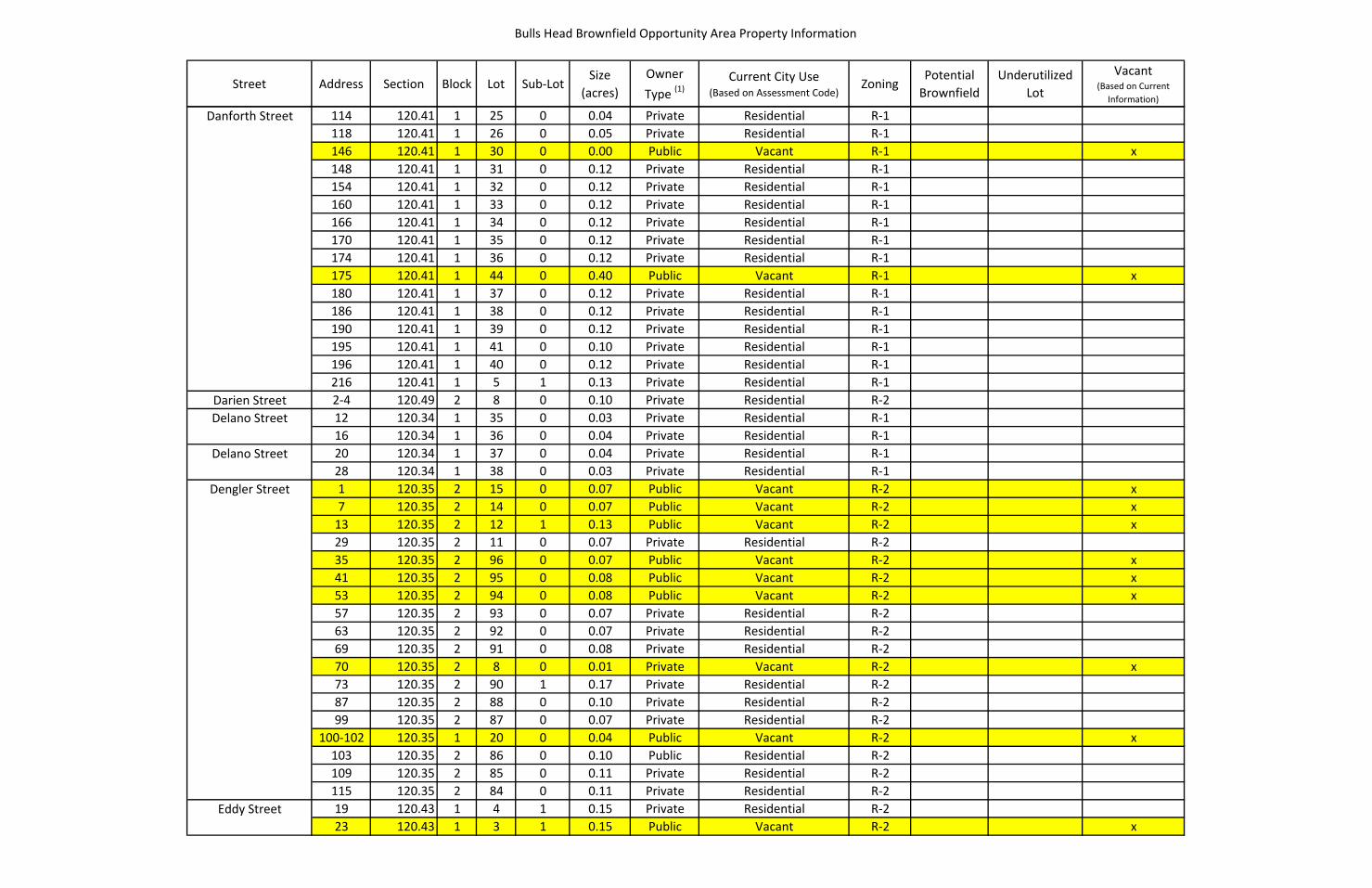
Bulls Head Brownfield Opportunity Area Property Information
Street Address Section Block Lot Sub-LotSize
(acres)Owner Type (1)
Current City Use (Based on Assessment Code)
ZoningPotential
BrownfieldUnderutilized
Lot
Vacant (Based on Current
Information)
Danforth Street 114 120.41 1 25 0 0.04 Private Residential R-1118 120.41 1 26 0 0.05 Private Residential R-1146 120.41 1 30 0 0.00 Public Vacant R-1 x148 120.41 1 31 0 0.12 Private Residential R-1154 120.41 1 32 0 0.12 Private Residential R-1160 120.41 1 33 0 0.12 Private Residential R-1166 120.41 1 34 0 0.12 Private Residential R-1170 120.41 1 35 0 0.12 Private Residential R-1174 120.41 1 36 0 0.12 Private Residential R-1175 120.41 1 44 0 0.40 Public Vacant R-1 x180 120.41 1 37 0 0.12 Private Residential R-1186 120.41 1 38 0 0.12 Private Residential R-1190 120.41 1 39 0 0.12 Private Residential R-1195 120.41 1 41 0 0.10 Private Residential R-1196 120.41 1 40 0 0.12 Private Residential R-1216 120.41 1 5 1 0.13 Private Residential R-1
Darien Street 2-4 120.49 2 8 0 0.10 Private Residential R-2Delano Street 12 120.34 1 35 0 0.03 Private Residential R-1
16 120.34 1 36 0 0.04 Private Residential R-1Delano Street 20 120.34 1 37 0 0.04 Private Residential R-1
28 120.34 1 38 0 0.03 Private Residential R-1Dengler Street 1 120.35 2 15 0 0.07 Public Vacant R-2 x
7 120.35 2 14 0 0.07 Public Vacant R-2 x13 120.35 2 12 1 0.13 Public Vacant R-2 x29 120.35 2 11 0 0.07 Private Residential R-235 120.35 2 96 0 0.07 Public Vacant R-2 x41 120.35 2 95 0 0.08 Public Vacant R-2 x53 120.35 2 94 0 0.08 Public Vacant R-2 x57 120.35 2 93 0 0.07 Private Residential R-263 120.35 2 92 0 0.07 Private Residential R-269 120.35 2 91 0 0.08 Private Residential R-270 120.35 2 8 0 0.01 Private Vacant R-2 x73 120.35 2 90 1 0.17 Private Residential R-287 120.35 2 88 0 0.10 Private Residential R-299 120.35 2 87 0 0.07 Private Residential R-2
100-102 120.35 1 20 0 0.04 Public Vacant R-2 x10³ 120.35 2 86 0 0.10 Public Residential R-2109 120.35 2 85 0 0.11 Private Residential R-2115 120.35 2 84 0 0.11 Private Residential R-2
Eddy Street 19 120.43 1 4 1 0.15 Private Residential R-223 120.43 1 3 1 0.15 Public Vacant R-2 x
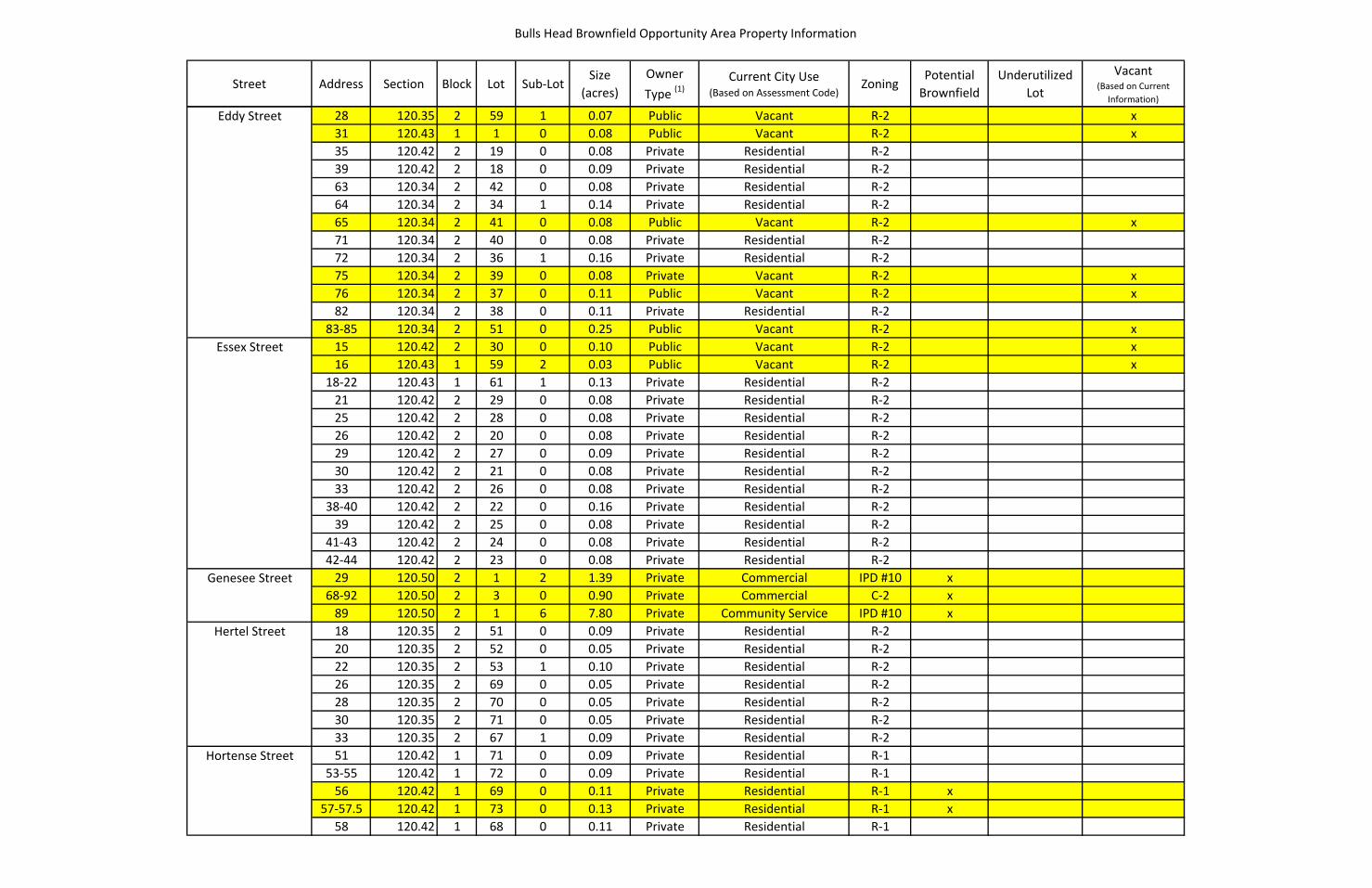
Bulls Head Brownfield Opportunity Area Property Information
Street Address Section Block Lot Sub-LotSize
(acres)Owner Type (1)
Current City Use (Based on Assessment Code)
ZoningPotential
BrownfieldUnderutilized
Lot
Vacant (Based on Current
Information)
Eddy Street 28 120.35 2 59 1 0.07 Public Vacant R-2 x31 120.43 1 1 0 0.08 Public Vacant R-2 x35 120.42 2 19 0 0.08 Private Residential R-239 120.42 2 18 0 0.09 Private Residential R-263 120.34 2 42 0 0.08 Private Residential R-264 120.34 2 34 1 0.14 Private Residential R-265 120.34 2 41 0 0.08 Public Vacant R-2 x71 120.34 2 40 0 0.08 Private Residential R-272 120.34 2 36 1 0.16 Private Residential R-275 120.34 2 39 0 0.08 Private Vacant R-2 x76 120.34 2 37 0 0.11 Public Vacant R-2 x82 120.34 2 38 0 0.11 Private Residential R-2
83-85 120.34 2 51 0 0.25 Public Vacant R-2 xEssex Street 15 120.42 2 30 0 0.10 Public Vacant R-2 x
16 120.43 1 59 2 0.03 Public Vacant R-2 x18-22 120.43 1 61 1 0.13 Private Residential R-2
21 120.42 2 29 0 0.08 Private Residential R-225 120.42 2 28 0 0.08 Private Residential R-226 120.42 2 20 0 0.08 Private Residential R-229 120.42 2 27 0 0.09 Private Residential R-230 120.42 2 21 0 0.08 Private Residential R-233 120.42 2 26 0 0.08 Private Residential R-2
38-40 120.42 2 22 0 0.16 Private Residential R-239 120.42 2 25 0 0.08 Private Residential R-2
41-43 120.42 2 24 0 0.08 Private Residential R-242-44 120.42 2 23 0 0.08 Private Residential R-2
Genesee Street 29 120.50 2 1 2 1.39 Private Commercial IPD #10 x68-92 120.50 2 3 0 0.90 Private Commercial C-2 x
89 120.50 2 1 6 7.80 Private Community Service IPD #10 xHertel Street 18 120.35 2 51 0 0.09 Private Residential R-2
20 120.35 2 52 0 0.05 Private Residential R-222 120.35 2 53 1 0.10 Private Residential R-226 120.35 2 69 0 0.05 Private Residential R-228 120.35 2 70 0 0.05 Private Residential R-230 120.35 2 71 0 0.05 Private Residential R-233 120.35 2 67 1 0.09 Private Residential R-2
Hortense Street 51 120.42 1 71 0 0.09 Private Residential R-153-55 120.42 1 72 0 0.09 Private Residential R-1
56 120.42 1 69 0 0.11 Private Residential R-1 x57-57.5 120.42 1 73 0 0.13 Private Residential R-1 x
58 120.42 1 68 0 0.11 Private Residential R-1

Bulls Head Brownfield Opportunity Area Property Information
Street Address Section Block Lot Sub-LotSize
(acres)Owner Type (1)
Current City Use (Based on Assessment Code)
ZoningPotential
BrownfieldUnderutilized
Lot
Vacant (Based on Current
Information)
Hortense Street 59 120.42 1 74 0 0.09 Private Residential R-161 120.42 1 75 0 0.09 Private Residential R-162 120.42 1 67 0 0.08 Private Residential R-1 x
63-65 120.42 1 76 0 0.09 Private Residential R-1 x99 120.42 1 1 1 0.16 Private Residential R-1
104 120.42 1 2 1 0.10 Private Residential R-1Jefferson Avenue 8 120.36 1 1 0 0.17 Public Vacant R-2 x
11 120.35 3 1 1 0.06 Public Vacant R-2 x12 120.36 1 88 0 0.11 Private Residential R-219 120.35 3 17 0 0.07 Private Commercial R-222 120.36 1 86 1 0.22 Private Residential R-225 120.35 3 18 0 0.09 Public Vacant R-2 x32 120.36 1 84 1 0.24 Private Residential R-233 120.35 3 19 0 0.14 Public Vacant R-2 x38 120.36 1 83 0 0.10 Private Residential R-2
39-47 120.35 3 21 1 0.21 Private Residential R-254 120.36 1 80 1 0.34 Private Residential R-255 120.35 3 22 0 0.10 Private Residential R-260 120.36 1 79 0 0.11 Public Vacant R-2 x
61-65 120.35 3 24 2 0.20 Public Vacant R-2 x66 120.36 1 78 0 0.11 Private Residential R-272 120.36 1 77 0 0.11 Private Residential R-2
74-76 120.36 1 76 0 0.11 Private Residential R-282 120.36 1 75 0 0.11 Private Residential R-2
83-85 120.35 4 4 2 0.17 Private Residential R-286 120.36 1 74 0 0.11 Private Residential R-2
87-89 120.35 4 5 0 0.07 Private Vacant R-2 x92 120.36 1 73 0 0.11 Private Residential R-293 120.35 4 6 0 0.28 Private Residential R-296 120.36 1 72 0 0.11 Public Residential R-2
101-103 120.35 4 7 0 0.06 Private Residential R-2102 120.36 1 71 0 0.11 Private Residential R-2
105-107 120.35 4 8 1 0.20 Private Residential R-2108 120.36 1 70 0 0.11 Private Residential R-2
112-114 120.36 1 69 0 0.11 Private Residential R-2118-120 120.36 1 68 1 0.23 Private Residential R-2
123 120.35 4 9 0 0.23 Private Residential R-2127 120.35 4 10 0 0.08 Private Residential R-2130 120.36 1 66 0 0.11 Private Residential R-2133 120.35 4 11 1 0.24 Public Vacant R-2 x
182-184 120.44 1 3 0 0.15 Private Commercial C-2

Bulls Head Brownfield Opportunity Area Property Information
Street Address Section Block Lot Sub-LotSize
(acres)Owner Type (1)
Current City Use (Based on Assessment Code)
ZoningPotential
BrownfieldUnderutilized
Lot
Vacant (Based on Current
Information)
Kensington Street 2 120.42 2 37 0 0.08 Public Residential R-24 120.42 2 38 1 0.17 Public Residential R-2 x5 120.42 2 48 0 0.17 Private Vacant C-2 x x7 120.42 2 47 0 0.08 Public Vacant C-2 x8 120.42 2 40 0 0.09 Private Residential R-2 x
10 120.42 2 41 0 0.09 Public Vacant R-2 x12 120.42 2 42 0 0.09 Private Residential R-213 120.42 2 60 2 0.38 Private Commercial C-2 x14 120.42 2 43 0 0.09 Public Vacant R-2 x17 120.42 2 46 0 0.09 Public Residential R-219 120.42 2 45 0 0.09 Private Residential R-221 120.42 2 44 0 0.09 Private Residential R-2
Love Street 12 120.35 1 47 0 0.05 Private Residential R-218 120.35 1 48 0 0.10 Private Residential R-221 120.35 1 45 1 0.21 Private Residential R-2
22-24 120.35 1 49 0 0.10 Private Residential R-225 120.34 2 30 0 0.10 Public Vacant R-2 x26 120.35 1 50 0 0.10 Private Vacant R-2 x29 120.34 2 29 0 0.15 Private Residential R-230 120.35 1 51 0 0.10 Private Residential R-236 120.35 1 52 0 0.10 Private Residential R-239 120.34 2 28 3 0.18 Private Residential R-240 120.35 1 54 1 0.20 Private Residential R-243 120.34 2 27 0 0.12 Private Residential R-247 120.34 2 26 0 0.12 Public Vacant R-2 x48 120.34 2 22 1 0.14 Private Residential R-252 120.34 2 21 1 0.14 Private Residential R-263 120.34 2 24 1 0.21 Private Vacant R-2 x64 120.34 2 18 1 0.17 Private Residential R-269 120.34 2 23 0 0.05 Private Residential R-274 120.34 2 16 1 0.11 Private Residential R-278 120.34 2 15 0 0.06 Private Residential R-2
Lynchford Park A 4 120.41 1 47 0 0.10 Private Residential R-18 120.41 1 46 0 0.10 Private Residential R-1
16 120.41 1 45 0 0.10 Private Residential R-1Lynchford Park B 7 120.41 1 42 0 0.10 Private Residential R-1
15 120.41 1 43 0 0.10 Private Residential R-1Moran Street 10 120.50 2 1 7 0.52 Private Commercial IPD #10 x
24 120.50 2 53 0 0.12 Private Commercial R-1 xNew York Street 4-4.5 120.35 4 18 0 0.10 Private Residential R-2
7 120.35 4 13 1 0.13 Private Residential R-2
Bulls Head Brownfield Opportunity Area Property Information
Street Address Section Block Lot Sub-LotSize
(acres)Owner Type (1)
Current City Use (Based on Assessment Code)
ZoningPotential
BrownfieldUnderutilized
Lot
Vacant (Based on Current
Information)
New York Street 8 120.35 4 16 2 0.37 Public Vacant R-2 x14 120.35 3 29 0 0.10 Private Residential R-2
16-18 120.35 3 30 1 0.18 Private Residential R-220 120.35 3 32 1 0.32 Private Residential R-225 120.43 1 22 0 0.11 Private Residential R-227 120.43 1 21 0 0.08 Private Residential R-232 120.35 3 36 3 0.10 Public Vacant R-2 x34 120.35 3 35 2 0.10 Private Residential R-2
Saxton Street 8 120.35 2 7 0 0.02 Public Vacant R-2 x10 120.35 2 6 0 0.06 Public Vacant R-2 x11 120.35 1 17 1 0.29 Public Vacant R-2 x14 120.35 2 5 0 0.09 Private Residential R-217 120.35 1 16 0 0.11 Private Residential R-218 120.35 2 4 0 0.09 Private Residential R-2
24-30 120.35 2 1 1 0.21 Private Public Service R-225 120.35 1 14 2 0.33 Private Residential R-244 120.27 2 64 0 0.01 Private Public Service R-2
Silver Street 11 120.35 2 17 0 0.07 Private Residential R-215 120.35 2 16 0 0.06 Private Residential R-217 120.35 2 10 0 0.75 Private Commercial R-219 120.35 2 9 0 0.21 Private Industrial R-222 120.35 1 27 0 0.10 Private Residential M-123 120.35 2 2 0 0.06 Private Commercial R-225 120.35 1 26 0 0.05 Private Residential R-228 120.35 1 28 0 0.10 Public Vacant M-1 x29 120.35 1 25 0 0.05 Private Residential R-232 120.35 1 29 0 0.33 Private Commercial M-1 x40 120.35 1 30 0 0.75 Private Commercial M-143 120.35 1 23 0 0.05 Public Vacant R-2 x47 120.35 1 22 0 0.06 Private Residential R-251 120.35 1 21 1 0.06 Private Residential R-252 120.35 1 31 0 0.26 Private Commercial M-157 120.35 2 83 0 0.11 Private Residential R-262 120.35 1 32 0 0.15 Private Vacant M-1 x63 120.35 2 82 0 0.14 Private Residential R-267 120.35 2 81 0 0.12 Private Residential R-270 120.35 1 33 0 0.25 Private Commercial M-173 120.35 2 80 0 0.13 Private Residential R-275 120.35 2 79 0 0.13 Private Residential R-279 120.35 2 78 0 0.13 Private Vacant R-2 x87 120.35 2 77 0 0.13 Private Residential R-2

Bulls Head Brownfield Opportunity Area Property Information
Street Address Section Block Lot Sub-LotSize
(acres)Owner Type (1)
Current City Use (Based on Assessment Code)
ZoningPotential
BrownfieldUnderutilized
Lot
Vacant (Based on Current
Information)
Silver Street 88 120.35 1 34 0 1.37 Private Commercial M-191 120.35 2 76 1 0.25 Public Residential R-296 120.35 1 35 0 0.11 Private Residential R-2
100 120.35 1 36 0 0.08 Public Vacant R-2 x101 120.35 2 74 0 0.13 Private Residential R-2
105-109 120.35 2 72 1 0.25 Private Residential R-2106 120.35 1 37 0 0.08 Private Residential R-2112 120.35 1 39 1 0.12 Public Vacant R-2 x122 120.35 1 40 0 0.09 Private Residential R-2126 120.35 1 41 1 0.16 Private Residential R-2127 120.35 2 66 0 0.06 Private Vacant R-2 x131 120.35 2 65 0 0.07 Private Residential R-2134 120.35 1 43 2 0.04 Public Vacant R-2 x135 120.35 2 64 0 0.07 Private Residential R-2138 120.35 1 43 1 0.04 Private Vacant R-2 x140 120.35 1 44 2 0.13 Private Residential R-2141 120.35 2 63 0 0.07 Private Residential R-2142 120.35 1 44 3 0.03 Private Vacant R-2 x144 120.34 2 31 0 0.11 Private Residential R-2145 120.35 2 62 0 0.07 Private Residential R-2148 120.34 2 32 1 0.15 Private Residential R-2149 120.35 2 61 0 0.07 Private Residential R-2
162-164 120.34 2 44 1 0.14 Private Residential R-2170 120.34 2 45 0 0.09 Public Vacant R-2 x174 120.34 2 46 0 0.09 Private Residential R-2178 120.42 2 17 0 0.03 Private Residential R-2
186-194 120.42 2 14 1 0.66 Private Residential R-2 x220 120.42 2 7 1 0.28 Public Vacant R-2 x239 120.42 2 77 0 0.09 Private Residential R-1 x
Taylor Street 5-7 120.42 2 8 0 0.09 Private Residential R-215 120.42 2 9 0 0.14 Private Residential R-219 120.42 2 10 0 0.14 Private Residential R-221 120.42 2 11 0 0.14 Private Residential R-224 120.42 2 12 0 0.07 Private Residential R-230 120.34 2 47 0 0.10 Private Residential R-231 120.34 2 78 0 0.16 Private Residential R-234 120.34 2 48 0 0.10 Public Residential R-235 120.34 2 77 0 0.12 Private Residential R-238 120.34 2 49 0 0.06 Private Residential R-239 120.34 2 76 0 0.06 Private Residential R-243 120.34 2 75 0 0.06 Private Vacant R-2 x
Bulls Head Brownfield Opportunity Area Property Information
Street Address Section Block Lot Sub-LotSize
(acres)Owner Type (1)
Current City Use (Based on Assessment Code)
ZoningPotential
BrownfieldUnderutilized
Lot
Vacant (Based on Current
Information)
Taylor Street 44 120.34 2 50 0 0.09 Private Vacant R-2 x51 120.34 2 74 0 0.24 Private Residential R-255 120.34 2 72 3 0.12 Public Vacant R-2 x61 120.34 2 72 2 0.12 Private Residential R-265 120.34 2 71 0 0.12 Public Vacant R-2 x69 120.34 2 70 0 0.12 Public Vacant R-2 x72 120.34 2 52 0 0.07 Public Residential R-273 120.34 2 69 0 0.06 Private Residential R-276 120.34 2 53 0 0.07 Private Residential R-279 120.34 2 68 0 0.06 Private Residential R-280 120.34 2 54 0 0.08 Private Residential R-283 120.34 2 67 1 0.17 Private Residential R-284 120.34 2 55 0 0.08 Private Vacant R-2 x90 120.34 2 56 0 0.08 Private Residential R-291 120.34 2 65 1 0.36 Private Residential R-294 120.34 2 57 0 0.06 Private Residential R-295 120.34 2 64 0 0.11 Private Residential R-298 120.34 2 58 0 0.06 Private Residential R-2
101 120.34 2 63 0 0.11 Private Residential R-2105 120.34 2 62 0 0.11 Private Vacant R-2 x10⁷ 120.34 2 61 0 0.11 Private Vacant R-2 x10⁹ 120.34 2 60 0 0.12 Public Vacant M-1 x110 120.34 2 14 0 0.25 Public Vacant M-1 x113 120.34 2 59 0 0.02 Private Vacant M-1 x
Terry Street 5 120.35 3 51 0 0.05 Private Residential R-26 120.35 3 16 2 0.05 Public Vacant R-2 x
7-7.5 120.35 3 52 0 0.11 Private Residential R-28 120.35 3 15 0 0.12 Private Residential R-29 120.35 3 53 0 0.11 Private Residential R-2
10 120.35 3 14 0 0.10 Public Vacant R-2 x11 120.35 3 54 2 0.11 Private Residential R-212 120.35 3 13 0 0.11 Private Residential R-213 120.35 3 54 3 0.05 Private Vacant R-2 x
14-16 120.35 3 12 1 0.22 Private Residential R-215 120.35 3 56 1 0.16 Private Residential R-2
Victoria Street 8 120.35 2 55 0 0.07 Private Residential R-29 120.43 1 10 1 0.10 Public Vacant C-2 x
12 120.35 2 56 0 0.07 Private Residential R-216 120.35 2 57 0 0.07 Private Residential R-220 120.35 2 58 0 0.07 Public Vacant R-2 x
W Main Street 600 120.36 1 65 0 0.45 Private Commercial C-2
Bulls Head Brownfield Opportunity Area Property Information
Street Address Section Block Lot Sub-LotSize
(acres)Owner Type (1)
Current City Use (Based on Assessment Code)
ZoningPotential
BrownfieldUnderutilized
Lot
Vacant (Based on Current
Information)
W Main Street 601-603 120.44 1 4 0 0.30 Private Commercial C-2613-625 120.44 1 2 0 0.36 Private Commercial C-2
614 120.44 1 1 0 0.22 Private Commercial C-2626 120.43 1 23 0 0.32 Private Commercial C-2
627-635 120.43 2 18 0 0.16 Private Commercial C-2636 120.43 1 24 1 0.56 Private Commercial C-2
639-643 120.43 2 17 0 0.14 Private Residential C-2644 120.43 1 25 1 0.16 Private Residential C-2645 120.43 2 16 0 0.42 Private Commercial C-2653 120.43 2 15 0 0.26 Private Commercial C-2
660-668 120.43 1 26 1 1.14 Private Community Service C-2672-674 120.43 1 27 0 0.23 Private Residential C-2
675 120.43 2 14 1 1.31 Private Commercial C-2684 120.43 1 28 0 0.22 Private Commercial C-2685 120.43 2 13 1 0.47 Private Commercial C-2700 120.43 1 29 0 0.47 Private Commercial C-2701 120.43 2 12 0 0.17 Private Commercial C-2706 120.43 1 30 0 0.12 Private Commercial C-2707 120.43 2 11 0 0.17 Private Commercial C-2712 120.43 1 31 0 0.27 Private Commercial C-2
715-723 120.43 2 10 0 0.44 Private Commercial C-2720 120.43 1 32 0 0.57 Private Community Service C-2731 120.43 2 9 0 0.30 Private Commercial C-2736 120.43 1 33 0 1.29 Private Community Service C-2737 120.43 2 8 0 0.13 Private Commercial C-2747 120.43 2 7 0 0.13 Private Commercial C-2
750-782 120.43 1 36 3 2.78 Private Community Service C-2 x751-757 120.43 2 6 0 0.12 Private Commercial C-2759-763 120.43 2 5 0 0.12 Private Commercial C-2765-771 120.43 2 4 0 0.42 Private Commercial C-2792-814 120.43 1 40 1 0.66 Private Commercial C-2 x795-801 120.43 2 3 0 0.34 Private Commercial C-2 x816-824 120.43 1 41 1 0.38 Private Commercial C-2 x819-827 120.43 2 2 0 0.66 Private Community Service C-2835-855 120.50 2 2 2 4.24 Private Commercial C-2 x842-848 120.42 2 51 2 0.37 Public Vacant C-2 x
856 120.42 2 52 0 0.09 Public Vacant C-2 x x878 120.42 2 59 2 0.02 Private Vacant C-2 x886 120.42 2 60 3 0.80 Private Commercial C-2 x
888-892 120.42 2 61 0 0.06 Public Commercial C-2 x894-898 120.42 2 62 1 0.11 Private Commercial C-2 x

Bulls Head Brownfield Opportunity Area Property Information
Street Address Section Block Lot Sub-LotSize
(acres)Owner Type (1)
Current City Use (Based on Assessment Code)
ZoningPotential
BrownfieldUnderutilized
Lot
Vacant (Based on Current
Information)
W Main Street 900 120.42 2 63 0 0.05 Public Commercial C-2 x904 120.42 2 64 0 0.06 Private Commercial C-2
906-910 120.42 2 65 0 0.10 Private Commercial C-2 x912-916 120.42 2 66 0 0.10 Private Commercial C-2 x x918-922 120.42 2 67 0 0.13 Private Commercial C-2924-930 120.42 2 68 0 0.14 Private Commercial C-2 x932-938 120.42 2 69 0 0.16 Private Commercial C-2 x
Wentworth Street 6 120.43 1 17 0 0.15 Private Residential R-210 120.43 1 18 0 0.09 Private Residential R-2
11-13 120.43 1 16 0 0.15 Private Residential R-214 120.43 1 20 1 0.15 Private Residential R-215 120.43 1 15 0 0.10 Public Residential R-219 120.35 3 76 0 0.08 Private Residential R-221 120.35 3 77 0 0.05 Private Residential R-222 120.35 3 74 1 0.16 Public Vacant R-2 x
23-25 120.35 3 79 1 0.16 Private Residential R-2West Avenue 4-12 120.42 1 47 0 0.32 Private Commercial C-2
24-26 120.42 1 49 1 0.23 Public Vacant C-2 x40 120.42 1 61 0 0.47 Private Community Service C-2 x45 120.50 1 6 0 0.09 Private Residential R-249 120.50 1 5 0 0.09 Private Residential R-255 120.50 1 4 0 0.12 Private Residential R-256 120.42 1 70 2 3.35 Private Community Service C-2 x65 120.50 1 3 0 0.15 Private Residential R-273 120.50 1 2 0 0.14 Private Residential R-2
107-109 120.50 1 1 0 1.25 Private Commercial R-2 x121-127 120.49 2 8 0 0.22 Private Commercial R-2
140 120.41 1 60 0 2.45 Private Commercial C-2143 120.49 2 7 0 0.32 Private Residential R-2165 120.49 2 6 0 0.55 Private Residential R-2185 120.49 2 5 0 0.25 Private Residential R-1195 120.49 2 4 0 0.16 Private Residential R-1200 120.41 1 61 0 4.51 Public Community Service O-S201 120.49 2 3 0 0.17 Private Residential R-1205 120.49 2 2 0 0.19 Private Residential R-1219 120.49 2 1 0 0.20 Private Residential R-1235 120.49 1 9 0 0.17 Private Residential R-1241 120.49 1 8 0 0.21 Private Residential R-1247 120.49 1 7 0 0.21 Private Residential R-1253 120.49 1 6 0 0.13 Public Residential R-1
253R 120.49 1 49 0 0.01 Private Vacant R-1 x
Bulls Head Brownfield Opportunity Area Property Information
Street Address Section Block Lot Sub-LotSize
(acres)Owner Type (1)
Current City Use (Based on Assessment Code)
ZoningPotential
BrownfieldUnderutilized
Lot
Vacant (Based on Current
Information)
West Avenue 261 120.49 1 5 0 0.16 Private Residential R-1273 120.49 1 4 0 0.28 Private Residential R-2279 120.49 1 3 0 0.47 Private Residential R-2295 120.49 1 2 0 0.28 Private Residential R-2303 120.49 1 1 0 0.17 Private Residential R-2
Wright Street 22 120.34 1 59 1 1.20 Private Commercial M-123 120.34 1 57 0 0.15 Private Residential R-129 120.34 1 56 0 0.15 Private Residential R-133 120.34 1 55 0 0.15 Private Residential R-139 120.34 1 54 0 0.15 Private Residential R-1
45-47 120.34 1 53 0 0.15 Private Residential R-149 120.34 1 52 0 0.15 Public Residential R-155 120.33 2 31 3 0.03 Public Vacant R-1 x61 120.33 2 31 2 0.03 Private Residential R-1
York Street 21-23 120.42 1 46 0 0.10 Public Commercial R-1 x24 120.42 2 70 0 0.22 Private Commercial C-2 x x27 120.42 1 45 0 0.10 Private Residential R-132 120.42 2 71 0 0.13 Private Commercial C-2 x x35 120.42 1 44 0 0.09 Private Residential R-137 120.42 1 43 0 0.07 Private Residential R-142 120.42 2 72 1 0.14 Private Commercial C-2 x x
43-55 120.42 1 40 1 0.47 Private Residential R-1 x50 120.42 2 73 0 0.23 Private Commercial C-2 x61 120.42 1 39 0 0.10 Private Residential R-164 120.42 2 74 0 0.15 Public Vacant R-1 x
65-67 120.42 1 38 0 0.11 Private Residential R-1 x68-70 120.42 2 75 0 0.11 Public Commercial R-171-73 120.42 1 37 0 0.10 Private Residential R-1
76 120.42 2 76 0 0.09 Public Residential R-186 120.42 2 4 0 0.14 Private Residential R-187 120.42 1 23 0 0.06 Public Vacant R-1 x90 120.42 2 3 0 0.14 Private Residential R-1 x93 120.42 1 22 0 0.10 Private Residential R-198 120.42 2 2 0 0.28 Private Commercial R-199 120.42 1 21 0 0.10 Private Residential R-1
103 120.42 1 20 0 0.09 Private Residential R-1107 120.42 1 19 0 0.12 Private Residential R-1108 120.42 2 1 0 0.14 Private Residential R-1112 120.34 2 79 0 0.16 Public Residential R-1
116-118 120.34 2 80 0 0.14 Private Residential R-1119 120.34 1 34 0 0.05 Private Residential R-1

Bulls Head Brownfield Opportunity Area Property Information
Street Address Section Block Lot Sub-LotSize
(acres)Owner Type (1)
Current City Use (Based on Assessment Code)
ZoningPotential
BrownfieldUnderutilized
Lot
Vacant (Based on Current
Information)
York Street 124 120.34 2 81 0 0.20 Private Residential R-1125 120.34 1 33 0 0.08 Private Vacant R-1 x129 120.34 1 32 0 0.05 Private Residential R-1131 120.34 1 31 0 0.09 Private Residential R-1132 120.34 2 82 0 0.12 Private Residential R-1134 120.34 2 83 1 0.24 Private Residential R-1135 120.34 1 30 0 0.11 Private Residential R-1139 120.34 1 29 0 0.11 Private Residential R-1
142-144 120.34 2 86 1 0.12 Private Residential R-1143 120.34 1 28 0 0.11 Private Residential R-1147 120.34 1 27 0 0.11 Public Residential R-1148 120.34 2 87 0 0.12 Private Residential R-1151 120.34 1 26 0 0.11 Private Vacant R-1 x152 120.34 2 88 0 0.12 Private Vacant R-1 x156 120.34 2 89 0 0.08 Private Vacant R-1 x157 120.34 1 25 0 0.11 Private Commercial R-1 x
160-162 120.34 2 90 0 0.17 Private Commercial R-1166 120.34 2 91 0 0.11 Public Vacant R-1 x170 120.34 2 92 0 0.11 Private Residential R-1171 120.34 1 24 0 1.57 Private Industrial M-1174 120.34 2 93 0 0.10 Public Vacant R-1 x180 120.34 2 94 0 0.14 Private Residential R-1
184-190 120.34 2 95 0 0.33 Private Commercial M-1 xNo Address 120.35 4 2 2 0.00 Private x
120.35 4 2 3 0.00 Private x(1) Owner type based on City of Rochester Real Estate Master Inventory, dated February 2009.
Preliminary Analysis
2-9
LAND OWNERSHIP
The following map graphic depicts land ownership patterns within the PBOA. Unity Health Systems
owns the largest occupied parcel within the PBOA. The City of Rochester also owns a sizeable number
of parcels, especially concentrated within the heart of the PBOA. Many of the properties owned by the
City of Rochester have resulted from foreclosures.
NATURAL RESOURCES
The PBOA contains few natural resources, consisting mainly of small parks and recreational fields
associated with community centers or as dedicated open space. Within the neighborhood, the Danforth
Community Center, located on West Avenue, provides the only recreational opportunity for residents.
The Susan B. Anthony Park on Madison Street, Wilson Park, the James Madison High School on
Kirkland Road and Gardner Street park provide other recreational opportunities just outside of the area.
There are no wetlands, floodplains, unique topography or land forms, streams or ponds located in the
immediate area as shown in Map 8. Groundwater in the area of the PBOA and the surrounding area is
not used as a source of potable water (municipal water is used in the area).
SUMMARY OF PRELIMINARY ANALYSIS AND RECOMMENDATIONS
Guiding Principles
Physical redevelopment of the area will be informed by both environmental and market conditions. As
the city moves forward in assessing potential land use and physical development options, the following
key principals will help inform future planning, decision making and policy affecting the PBOA.
Respecting Human Scale
Buildings and public spaces must relate to one another in a way that respects the human scale. Building
size is an important consideration in this neighborhood focal point. Creating human-scaled development
will also depend on how structures are sited on lots, how the property relates to the public realm, and
how open space, landscaping and streetscape elements are incorporated into the design.
Sustainable Patterns of Development
The pattern of development, which is the footprint of a community, greatly impacts long-term success
and viability. How and where land uses, transportation and community resources are located and
connected significantly impacts how people live their lives and meet their daily needs. Sustainable
development patterns maximize available land and existing infrastructure. The plan for the project site
will need to enhance physical connections and encourage designs that maximize community resources,
2-10
Bull’s Head Neighborhood Pre-Nomination Study
improve inter-relationships among people and places, and ensure that all elements of community are
adequately addressed.
Development patterns are influenced by the way that individual parcels are developed. The internal
organization and development of these parcels will directly and indirectly impact the vibrancy, function,
attractiveness and performance of the entire project site. Buildings should be located close to the street
edge with zero or minimal setbacks. Vehicular access should be safely accommodated to the rear or side
of buildings whenever possible. Pedestrian linkages among adjacent development should be well-
defined, safe, and inviting.
Landscaping and Streetscaping
Often overlooked or undervalued, the physical and natural landscape of communities greatly impacts
their perceived quality, viability, and sustainability. Landscaping includes many common types of
foliage such as street trees, planters, vines, and ground cover. Streetscaping also includes sidewalks,
street lights, hardscapes, and other amenities that create the edges and define the focal points of our
landscaped areas. When combined, they create lush environments, shade our roadways, and enhance
our physical surroundings.
Mixed Use
The traditional urban model for development incorporates multiple uses into a single area or structure.
Development in these areas is typically dictated by form, not use. The result is an active area where
people can live, work, and play within a walkable distance. Activity along the street adds to the
liveliness and interest of an area and contributes to an ambiance of vitality and safety.
Multi-Modal Access
Successful urban neighborhoods easily accommodate multiple modes of transportation and their related
accommodations. Transportation facilities and networks must connect a wide variety of uses and provide
safe and secure passage for pedestrians, bicyclists and motorists.
From street patterns and roadway design to pedestrian and bicycle furnishings, the recommendations in
this plan will define reasonable and attractive spaces for movement throughout the project area. The
recommendations will expand opportunities for other modes of travel, creating connected, walkable
places where they make the most sense and ensuring safe vehicular movement throughout.
History and Character
The neighborhood’s rich history should be reflected in the physical and programmatic enhancements
made over time. The project area’s character has been influenced by Bull’s Heads historic role as the
western gateway to Rochester’s Center City and its present day proximity to other historic areas and
attractions. The physical character of this historic neighborhood should be reflected in Bull’s Head’s
redevelopment, whether its current form remains or the area is newly defined. The project area’s sense
of place should be defined by and reflected in its design. From signage and wayfinding to building

Preliminary Analysis
2-11
styles and materials, a recognizable theme should be developed to tie the area together and create a
logical connection to nearby neighborhoods.
People Promote Activity
Vibrant streets attract activity throughout the day and evening. Businesses and neighborhood centers
thrive in areas where residential development is closely located. Infusing diverse residential living
opportunities not currently available directly within the PBOA will be a critical consideration. Whether
revitalizing existing residential living spaces or creating new ones, their impact on the surrounding
community’s vitality and future sustainability is significant.
Defensible Spaces
Public spaces need to be safe and comfortable for the residents, employees, merchants and visitors.
Defensible spaces are achieved through well designed lighting, obvious connectivity, façade and site
transparency, and well established relationships between structures and surrounding public spaces (e.g.
sidewalks, streets, parking areas). Development should be easy to move to and through and access for
all modes of transportation is obvious and well organized.
Attention to Detail
Addressing the details, in both the public and private realm, will enhance how the area looks, feels, and
flows. In community planning and design, details can take many forms. Urban furnishings—lighting,
benches, trash receptacles, public art, fountains, etc.—help determine the level of engagement and
interest in public and private spaces. When located appropriately and in a manner that promotes safety,
they provide continuity and unity and help establish a sense of place.
Target Area Planning
In order to leverage planning efforts to date, maximize investment in advanced studies and improve the
likelihood of successful implementation of proposed recommendations and redevelopment alternatives,
the PBOA will be divided into logical sub-areas for further study and analysis. The sub-areas will be
defined based on physical and community attributes, past planning and data collection efforts to date.
Although community and boundary profiles will be compiled universally and an overall redevelopment
scheme will be created for the entire PBOA, the specific goals and level of analysis of each sub-area will
be vary. For example, planning and analysis for the already defined sub-area will include the preparation
of Phase I site assessments for each parcel to make them available (and more attractive to potential
developer) for comprehensive redevelopment.


Or
lea
ns
Or
lea
ns
G e n e s e eG e n e s e e
L i v i n g s t o nL i v i n g s t o n
Lake Ontario
W a y n eW a y n e
Rochester
ChiliRiga
GreeceParma
Hamlin
Rush
Ogden
Mendon
Penfield
Perinton
Sweden
Webster
Henrietta
Clarkson
Wheatland
Pittsford
Gates
Brighton
Irondequoit
EastRochester
Hilton
Brockport Webster
Fairport
Honeoye Falls
Spencerport
Churchville
Scottsville
Pittsford
Bull's Head NeighborhoodBrownfield Opportunity Area
MAP 1: COMMUNITY CONTEXTLegend
City Boundary
Town Boundary
Village Boundary
State Roads
Local Roads
1 inch = 4 miles
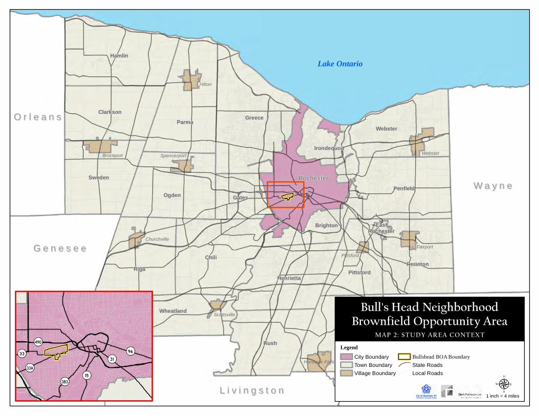
O r l e a n sO r l e a n s
G e n e s e eG e n e s e e
L i v i n g s t o nL i v i n g s t o n
Lake Ontario
W a y n eW a y n eRochester
ChiliRiga
GreeceParma
Hamlin
Rush
Ogden
Mendon
Penfield
Perinton
Sweden
Webster
Henrietta
Clarkson
Wheatland
Pittsford
Gates
Brighton
Irondequoit
EastRochester
Hilton
Brockport Webster
Fairport
Honeoye Falls
Spencerport
Churchville
Scottsville
Pittsford
Bull's Head NeighborhoodBrownfield Opportunity Area
MAP 2: STUDY AREA CONTEXTLegend
City Boundary
Town Boundary
Village Boundary
Bullshead BOA BoundaryState Roads
Local Roads
1 inch = 4 miles
96
490
31
15
33A
383
33

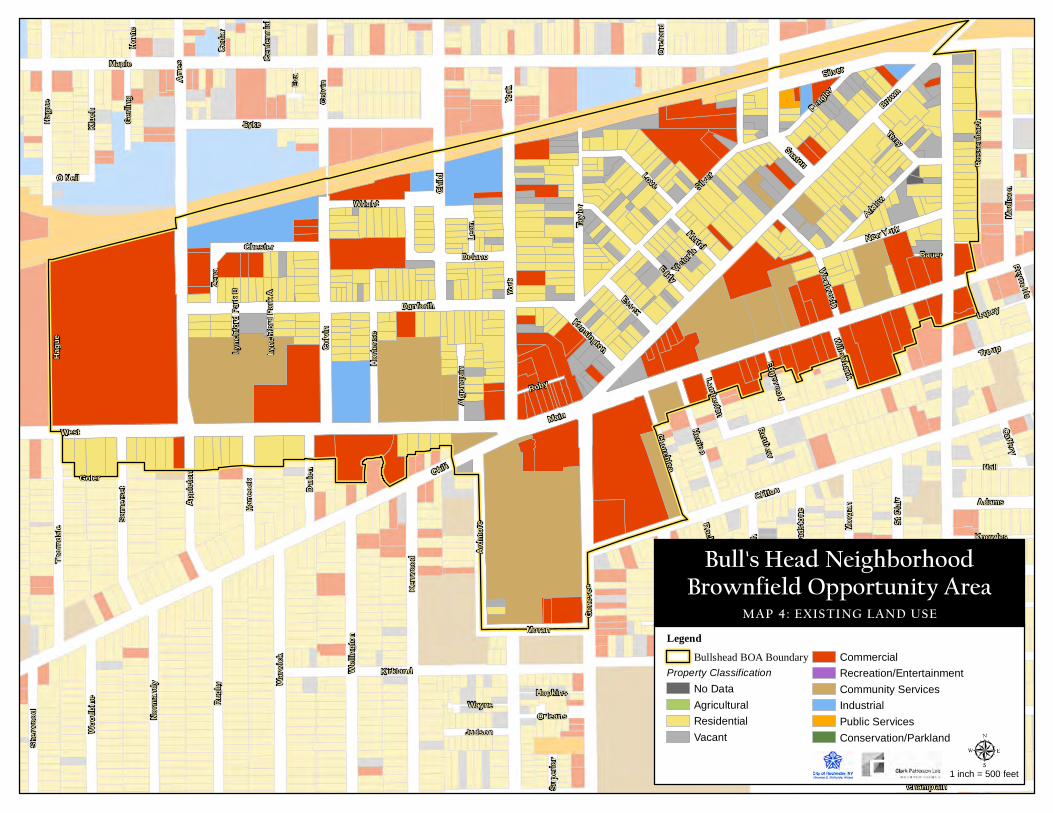
Maple
Chili
MainWest
Brown
Jeffe
rson
Ames
CliftonYo
rk
Troup
Child
Cady
Syke
Silver
Gene
see
Danforth
Kirkland
Epwo
rth
Colvi
n
Kenw
ood
Rugb
y
Heisel
Warw
ick
Hagu
e
TremontTa
ylor
Wellin
gton
Eddy
Champlain
Dr Samuel McCree
Saxton
Thor
ndale
Love
HallAr
dmor
e
Henion
Some
rset
Klue
h
Norm
andy
Dengler
Arklow
Horte
nse
Chester
Apple
ton
Terry
Ross
enba
ch
St C
lair
Moran
Delano
Wood
bine
Darie
n
Hanc
ock
New York
Morg
an
Churchlea
Lapey
Madis
on
Sherw
ood
Judson
Adams
Hertel
Wood
en
Wright
Essex
WentworthZe
na
Gerlin
g
Goler
Ruby
Knowles
Rockland
WayneOrleans
Hopkins
Glad
stone
Eva
Leon
Algo
nquin
Kensington
Home
Ceda
r
Caffery
Edgewood
O Neil
Lamberton
Willowbank
Reynolds
Victoria Bauer
Orch
ard
Supe
rior
RenfrewCe
ntenn
ialLy
nchfo
rd Pa
rk A
Lync
hford
Park
B
Jefferson
Hagu
e
Colvi
n
York
Silver
Tremont
LegendBullshead BOA Boundary
Property ClassificationNo Data
Agricultural
Residential
Vacant
Commercial
Recreation/Entertainment
Community Services
Industrial
Public Services
Conservation/Parkland
1 inch = 500 feet
Bull's Head NeighborhoodBrownfield Opportunity Area
MAP 4: EXISTING LAND USE
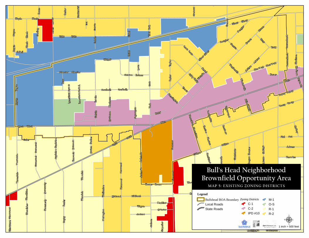
Maple
Chili
MainWest
Brown
Jeffe
rson
Ames
CliftonYo
rk
Troup
Child
Cady
Syke
Silver
Gene
see
Danforth
Kirkland
Epwo
rth
Colvi
n
Kenw
ood
Rugb
y
Heisel
Warw
ick
Hagu
e
TremontTa
ylor
Wellin
gton
Eddy
Champlain
Dr Samuel McCree
Saxton
Thor
ndale
Love
HallAr
dmor
e
Henion
Some
rset
Klue
h
Norm
andy
Dengler
Arklow
Horte
nse
Chester
Apple
ton
Terry
Ross
enba
ch
St C
lair
Moran
Delano
Wood
bine
Darie
n
Hanc
ock
New York
Morg
an
Churchlea
Lapey
Madis
on
Sherw
ood
Judson
Adams
Hertel
Wood
en
Wright
Essex
WentworthZe
na
Gerlin
g
Goler
Ruby
Knowles
Rockland
WayneOrleans
Hopkins
Glad
stone
Eva
Leon
Algo
nquin
Kensington
Home
Ceda
r
Caffery
Edgewood
O Neil
Lamberton
Willowbank
Reynolds
Victoria Bauer
Orch
ard
Supe
rior
RenfrewCe
ntenn
ialLy
nchfo
rd Pa
rk A
Lync
hford
Park
B
Jefferson
Hagu
e
Colvi
n
York
Silver
Tremont
Maple
Chili
Main
West
Brown
Jeffe
rson
Ames
CliftonYo
rk Troup
Child
Cady
Syke
Silver
Gene
see
Danforth
Kirkland
Epwo
rth
Colvi
n
Kenw
ood
Rugb
y
Heisel
Warw
ick
Hagu
e
TremontTa
ylor
Wellin
gton
Eddy
Champlain
Dr Samuel McCree
Saxto
n
Thor
ndale
Love
HallAr
dmor
e
Henion
Some
rset
Klue
h
Norm
andy
Dengler
Arklow
Horte
nse
Chester
Apple
ton
Terry
Ross
enba
ch
St C
lair
Moran
Delano
Wood
bine
Darie
n
Hanc
ock
New York
Morg
an
Churchlea
Lapey
MadisonSh
erwoo
d
Juds
on
Wooden
Wentworth
Rockland Jefferson
Colvi
n York
Silver
Hagu
e
LegendBullshead BOA BoundaryLocal Roads
State Roads
Zoning DistrictsC-1
C-2
IPD #10
M-1
O-S
R-1
R-2
1 inch = 500 feet
Bull's Head NeighborhoodBrownfield Opportunity Area
MAP 5: EXISTING ZONING DISTRICTS
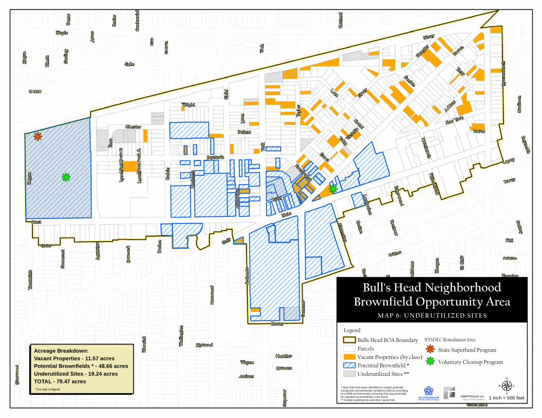
Maple
Chili
MainWest
Brown
Jeffe
rson
Ames
CliftonYo
rk
Troup
Child
Cady
Syke
Silver
Gene
see
Danforth
Kirkland
Epwo
rth
Colvi
n
Kenw
ood
Rugb
y
Heisel
Warw
ick
Hagu
e
TremontTa
ylor
Wellin
gton
Eddy
Champlain
Dr Samuel McCree
Saxton
Thor
ndale
Love
HallAr
dmor
e
Henion
Some
rset
Klue
h
Norm
andy
Dengler
Arklow
Horte
nse
Chester
Apple
ton
Terry
Ross
enba
ch
St C
lair
Moran
Delano
Wood
bine
Darie
n
Hanc
ock
New York
Morg
an
Churchlea
Lapey
Madis
on
Sher
wood
Judson
Adams
Hertel
Wood
en
Wright
Essex
WentworthZe
na
Gerli
ng
Goler
Ruby
Knowles
Rockland
WayneOrleans
Hopkins
Glad
stone
Eva
Leon
Algo
nquin
Kensington
Home
Ceda
r
Caffery
Edgewood
O Neil
Lamberton
Willowbank
Reynolds
Victoria Bauer
Orch
ard
Supe
rior
RenfrewCe
nten
nial
Lync
hfor
d Par
k A
Lync
hfor
d Par
k B
Jefferson
Hagu
e
Colvi
n
York
Silver
Tremont
LegendBulls Head BOA BoundaryParcelsVacant Properties (by class)Potential Brownfield *Underutilized Sites **
NYSDEC Remediation SitesState Superfund ProgramVoluntary Cleanup Program
1 inch = 500 feet
Bull's Head NeighborhoodBrownfield Opportunity Area
MAP 6: UNDERUTILIZED SITES
* Sites that have been identified to contain potentialrecognized environmental conditions (RECs) accordingto a 2009 environmental screening that may poteniallybe classified as browfields in the future** Includes parking lots and other vacant lots
Acreage Breakdown:Vacant Properties - 11.57 acresPotential Brownfields * - 48.66 acresUnderutilized Sites - 19.24 acresTOTAL - 79.47 acres* See note in legend
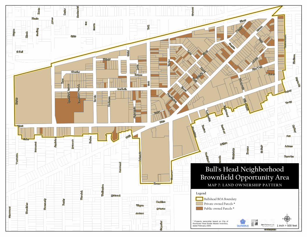
Maple
Chili
MainWest
Brown
Jeffe
rson
Ames
CliftonYo
rk
Troup
Child
Cady
Syke
Silver
Gene
see
Danforth
Kirkland
Epwo
rth
Colvi
n
Kenw
ood
Rugb
y
Heisel
Warw
ick
Hagu
e
TremontTa
ylor
Wellin
gton
Eddy
Champlain
Dr Samuel McCree
Saxton
Thor
ndale
Love
HallAr
dmor
e
Henion
Some
rset
Klue
h
Norm
andy
Dengler
Arklow
Horte
nse
Chester
Apple
ton
Terry
Ross
enba
ch
St C
lair
Moran
Delano
Wood
bine
Darie
n
Hanc
ock
New York
Morg
an
Churchlea
Lapey
Madis
on
Sherw
ood
Judson
Adams
Hertel
Wood
en
Wright
Essex
WentworthZe
na
Gerlin
g
Goler
Ruby
Knowles
Rockland
WayneOrleans
Hopkins
Glad
stone
Eva
Leon
Algo
nquin
Kensington
Home
Ceda
r
Caffery
Edgewood
O Neil
Lamberton
Willowbank
Reynolds
Victoria Bauer
Orch
ard
Supe
rior
RenfrewCe
ntenn
ialLy
nchfo
rd Pa
rk A
Lync
hford
Park
B
Jefferson
Hagu
e
Colvi
n
York
Silver
Tremont
LegendBullshead BOA BoundaryPrivate-owned Parcels *Public-owned Parcels *
1 inch = 500 feet
Bull's Head NeighborhoodBrownfield Opportunity Area
MAP 7: LAND OWNERSHIP PATTERN
* Property ownership based on CIty ofRochester Real Estate Master Inventory,dated February 2009.
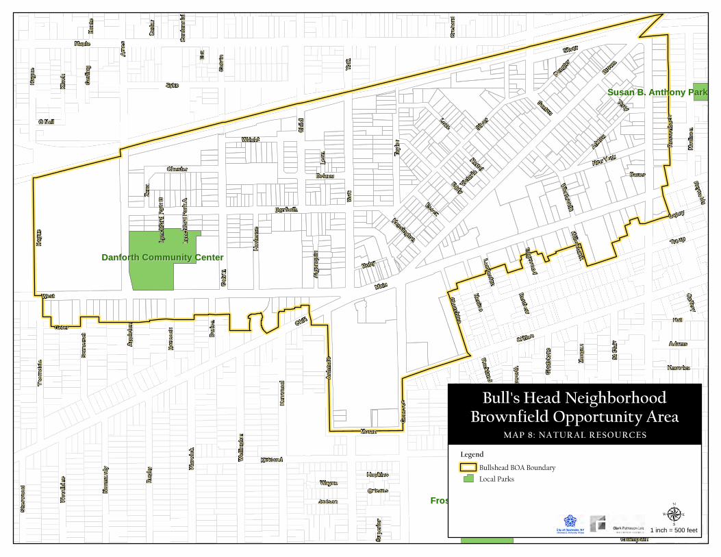
Frost Avenue/Wilson ParkFrost Avenue/Wilson Park
Danforth Community CenterDanforth Community Center
Susan B. Anthony ParkSusan B. Anthony Park
Maple
Chili
MainWest
Brown
Jeffe
rson
Ames
CliftonYo
rk
Troup
Child
Cady
Syke
Silver
Gene
see
Danforth
Kirkland
Epwo
rth
Colvi
n
Kenw
ood
Rugb
y
Heisel
Warw
ick
Hagu
e
TremontTa
ylor
Wellin
gton
Eddy
Champlain
Dr Samuel McCree
Saxton
Thor
ndale
Love
HallAr
dmor
e
Henion
Some
rset
Klue
h
Norm
andy
Dengler
Arklow
Horte
nse
Chester
Apple
ton
Terry
Ross
enba
ch
St C
lair
Moran
Delano
Wood
bine
Darie
n
Hanc
ock
New York
Morg
an
Churchlea
Lapey
Madis
on
Sherw
ood
Judson
Adams
Hertel
Wood
en
Wright
Essex
WentworthZe
na
Gerlin
g
Goler
Ruby
Knowles
Rockland
WayneOrleans
Hopkins
Glad
stone
Eva
Leon
Algo
nquin
Kensington
Home
Ceda
r
Caffery
Edgewood
O Neil
Lamberton
Willowbank
Reynolds
Victoria Bauer
Orch
ard
Supe
rior
RenfrewCe
ntenn
ialLy
nchfo
rd Pa
rk A
Lync
hford
Park
B
Jefferson
Hagu
e
Colvi
n
York
Silver
Tremont
LegendBullshead BOA BoundaryLocal Parks
1 inch = 500 feet
Bull's Head NeighborhoodBrownfield Opportunity Area
MAP 8: NATURAL RESOURCES

City of Rochester Clark Patterson Lee
Bull’s Head Neighborhood Pre-Nomination Study
Appendix A Photo Inventory

This page has been left blank intentionally.
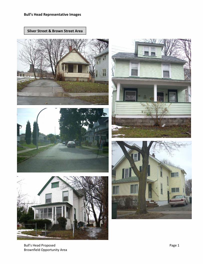
Bull’s Head Representative Images
Bull’s Head Proposed Page 1 Brownfield Opportunity Area
Silver Street & Brown Street Area
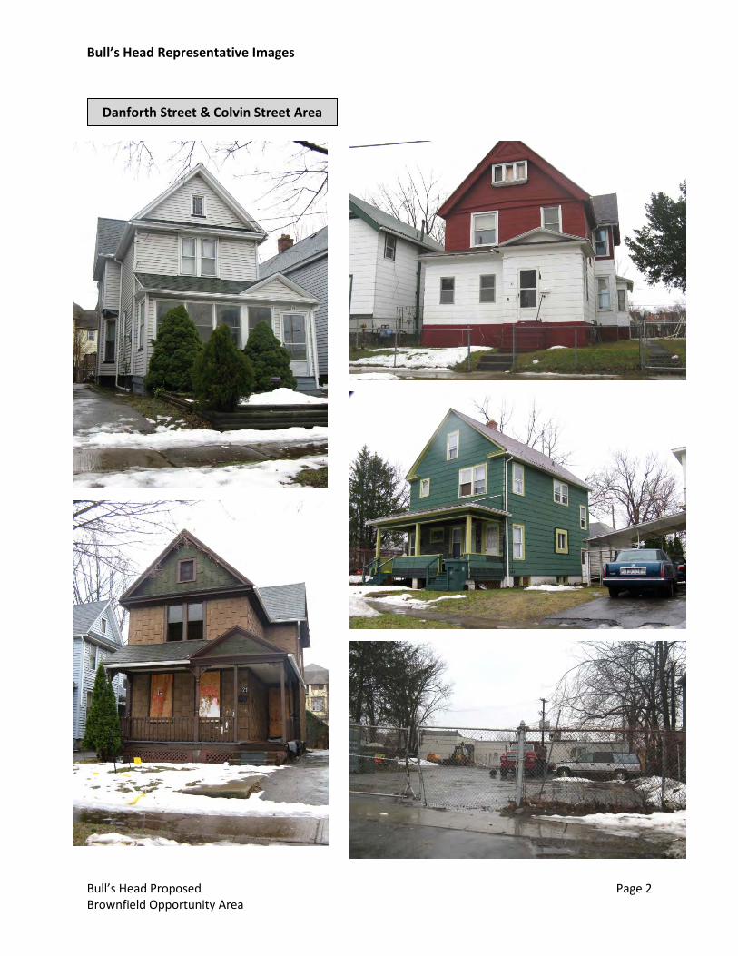
Bull’s Head Representative Images
Bull’s Head Proposed Page 2 Brownfield Opportunity Area
Danforth Street & Colvin Street Area

Bull’s Head Representative Images
Bull’s Head Proposed Page 3 Brownfield Opportunity Area
West Main Street & Brown Street
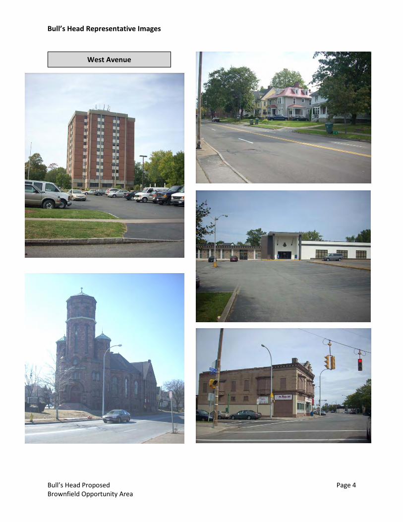
Bull’s Head Representative Images
Bull’s Head Proposed Page 4 Brownfield Opportunity Area
West Avenue