broadview and eastern flood protection project due
TRANSCRIPT

Toronto and Region Conservation Authority
Broadview and Eastern Flood Protection Project Due Diligence and Municipal Class Environmental Assessment (Pending City Approval) – Hydraulic Modelling and Conceptual Design Report - FINAL
Prepared by:
AECOM
50 Sportsworld Crossing Road, Suite 2900 519 650 5313 tel
Kitchener ON, Canada N2P 0A4 519 650 3424 fax
www.aecom.com
September 2019 Project Number: 60554370

RPT-2019-09-16-BEFP Hydraulic Modelling Report-60554370-FINAL.Docx
Distribution List
# Hard Copies PDF Required Association / Company Name
✓ Toronto and Region Conservation Authority
✓ AECOM Canada Ltd.

AECOM Toronto and Region Conservation Authority
Broadview and Eastern Flood Protection Project
Due Diligence and Municipal Class Environmental Assessment
Hydraulic Modelling and Conceptual Design Report
RPT-2019-09-16-BEFP Hydraulic Modelling Report-60554370-FINAL.Docx
Statement of Qualifications and Limitations
The attached Report (the “Report”) has been prepared by AECOM Canada Ltd. (“AECOM”) for the benefit of the Client (“Client”) in
accordance with the agreement between AECOM and Client, including the scope of work detailed therein (the “Agreement”).
The information, data, recommendations and conclusions contained in the Report (collectively, the “Information”):
▪ is subject to the scope, schedule, and other constraints and limitations in the Agreement and the qualifications
contained in the Report (the “Limitations”);
▪ represents AECOM’s professional judgement in light of the Limitations and industry standards for the preparation of
similar reports;
▪ may be based on information provided to AECOM which has not been independently verified;
▪ has not been updated since the date of issuance of the Report and its accuracy is limited to the time period and
circumstances in which it was collected, processed, made or issued;
▪ must be read as a whole and sections thereof should not be read out of such context;
▪ was prepared for the specific purposes described in the Report and the Agreement; and
▪ in the case of subsurface, environmental or geotechnical conditions, may be based on limited testing and on the
assumption that such conditions are uniform and not variable either geographically or over time.
AECOM shall be entitled to rely upon the accuracy and completeness of information that was provided to it and has no
obligation to update such information. AECOM accepts no responsibility for any events or circumstances that may have
occurred since the date on which the Report was prepared and, in the case of subsurface, environmental or geotechnical
conditions, is not responsible for any variability in such conditions, geographically or over time.
AECOM agrees that the Report represents its professional judgement as described above and that the Information has been
prepared for the specific purpose and use described in the Report and the Agreement, but AECOM makes no other
representations, or any guarantees or warranties whatsoever, whether express or implied, with respect to the Report, the
Information or any part thereof.
Without in any way limiting the generality of the foregoing, any estimates or opinions regarding probable construction costs or
construction schedule provided by AECOM represent AECOM’s professional judgement in light of its experience and the
knowledge and information available to it at the time of preparation. Since AECOM has no control over market or economic
conditions, prices for construction labour, equipment or materials or bidding procedures, AECOM, its directors, officers and
employees are not able to, nor do they, make any representations, warranties or guarantees whatsoever, whether express or
implied, with respect to such estimates or opinions, or their variance from actual construction costs or schedules, and accept no
responsibility for any loss or damage arising therefrom or in any way related thereto. Persons relying on such estimates or
opinions do so at their own risk.
Except (1) as agreed to in writing by AECOM and Client; (2) as required by-law; or (3) to the extent used by governmental
reviewing agencies for the purpose of obtaining permits or approvals, the Report and the Information may be used and relied
upon only by Client.
AECOM accepts no responsibility, and denies any liability whatsoever, to parties other than Client who may obtain access to the
Report or the Information for any injury, loss or damage suffered by such parties arising from their use of, reliance upon, or
decisions or actions based on the Report or any of the Information (“improper use of the Report”), except to the extent those
parties have obtained the prior written consent of AECOM to use and rely upon the Report and the Information. Any injury, loss
or damages arising from improper use of the Report shall be borne by the party making such use.
This Statement of Qualifications and Limitations is attached to and forms part of the Report and any use of the Report is subject
to the terms hereof.
AECOM: 2015-04-13
© 2009-2015 AECOM Canada Ltd. All Rights Reserved.
AECOM Toronto and Region Conservation Authority
Broadview and Eastern Flood Protection Project
Due Diligence and Municipal Class Environmental Assessment
Hydraulic Modelling and Conceptual Design Report
RPT-2019-09-16-BEFP Hydraulic Modelling Report-60554370-FINAL.Docx
Authors
Report Prepared
By:
Anya Yi, P.Eng.
Water Resources Engineer
Xiaoxu Qu, P.Eng, M.Eng
Water Resources Engineer
Report Reviewed
By:
Pippy Warburton, P.Eng
Manager, Water Resources

AECOM Toronto and Region Conservation Authority
Broadview and Eastern Flood Protection Project
Due Diligence and Municipal Class Environmental Assessment
Hydraulic Modelling and Conceptual Design Report
RPT-2019-09-16-BEFP Hydraulic Modelling Report-60554370-FINAL.Docx
Table of Contents
page
1. Introduction .................................................................................................... 1
1.1 Study Purpose and Scope ................................................................................................. 2
1.2 Background Data Review................................................................................................... 3
2. Baseline Surface and Model Update ........................................................... 4
2.1 Topographic and Bathymetric Surface Update ................................................................... 4
2.2 2D Model Update and Results ........................................................................................... 4
3. Development and Initial Screening of Options .......................................... 6
3.1 Do Nothing ......................................................................................................................... 6
3.2 Channel Widening.............................................................................................................. 6
3.2.1 Preliminary Hydraulics Assessment........................................................................ 7
3.2.2 Previous Assessments ........................................................................................... 7
3.2.3 Further Consideration of Flow Diversion and Storage ............................................ 7
3.2.4 Recommendation for Channel Widening Alternative ............................................... 8
3.3 Flood protection landform Options ..................................................................................... 8
3.3.1 Flood Protection Landform Design Criteria and Considerations .............................. 8
3.3.1.1 Landform Design Criteria ................................................................................. 9 3.3.1.2 Geotechnical Considerations .......................................................................... 10
3.3.2 Option 3A FPL ...................................................................................................... 11 3.3.3 Option 3B FPL ...................................................................................................... 11
3.3.4 Option 3Bi FPL ..................................................................................................... 12
3.4 Flood Protection Structure Options .................................................................................. 12
3.4.1 Floodwall Design and Construction Considerations .............................................. 12
3.4.2 Option 4A Floodwall ............................................................................................. 13
3.4.3 Option 4B Floodwall ............................................................................................. 14
3.4.4 Option 4C Floodwall ............................................................................................. 14
3.4.5 Option 4D Flood Protection Berm ......................................................................... 14
3.4.6 Option 4E Floodwall & Building Flood Proofing .................................................... 14
3.5 Operation & Maintenance Considerations ........................................................................ 16
3.6 Initial Screening of Options .............................................................................................. 16
3.6.1 Initial Screening of Options ................................................................................... 16
4. Refinement of Short Listed Options – Stage 2 ......................................... 19
4.1 Design Considerations and Geometry Refinement........................................................... 19
4.1.1 FPL Dry Side Scour Analysis................................................................................ 19
4.1.2 Seepage Analysis................................................................................................. 19
4.1.3 FPL Grading Refinement ...................................................................................... 21
4.2 Hydraulic Validation of Short Listed Options .................................................................... 21
4.2.1 Option 3R ............................................................................................................. 21
4.2.2 Option 4B ............................................................................................................. 22
4.2.3 Option 4C ............................................................................................................. 23

AECOM Toronto and Region Conservation Authority
Broadview and Eastern Flood Protection Project
Due Diligence and Municipal Class Environmental Assessment
Hydraulic Modelling and Conceptual Design Report
RPT-2019-09-16-BEFP Hydraulic Modelling Report-60554370-FINAL.Docx
5. Conclusion and Recommendations .......................................................... 24
6. References ................................................................................................... 26
List of Tables
Table 3.1: Initial Screening of Options ................................................................................................................... 18
Table 4.1: USACE Guidance for Exit Gradients .................................................................................................... 20
Table 4.2: Calculated Flow Quantities and Exist Gradients ................................................................................... 20
Table 4.3: Summary of MIKE 21 Modeling Scenarios ........................................................................................... 21
List of Attached Figures
Figure 1.1 Study Area and Adjacent Projects
Figure 2.1 Topographic and Bathymetric Surface Update
Figure 2.2 Updated Baseline Regional Steady Water Surface Elevation
Figure 2.3 Updated Baseline Regional Steady Depth
Figure 2.4 Updated Baseline Regional Steady Velocity
Figure 2.5 Updated Baseline Regional Steady Risk
Figure 2.6 Updated Baseline 350 Year Steady Depth
Figure 2.7 Updated Baseline 350 Year Steady Velocity
Figure 2.8 Updated Baseline 350 Year Steady Risk
Figure 2.9 Updated Baseline 100 Year Steady Depth
Figure 2.10 Updated Baseline 100 Year Steady Velocity
Figure 2.11 Updated Baseline 100 Year Steady Risk
Figure 3.1 Preliminary Hydraulic Analysis for Channel Widening
Figure 3.2 Sketch of Typical Berm/Levee and Flood Protection Landform (FPL)
Figure 3.3 Option 3A Plan
Figure 3.4 Option 3B Plan
Figure 3.5 Option 3Bi Plan
Figure 3.6 Option 3Bi Profile
Figure 3.7 Option 4A Plan
Figure 3.8 Option 4B Plan
Figure 3.9 Option 4C Plan
Figure 3.10 Option 4D Plan
Figure 3.11 Option 4D Profile
Figure 4.1 Preferred Option Plan
Figure 4.2 Preferred Option Profile A-A and B-B
Figure 4.3 Preferred Option Profile C-C
Figure 4.4 Preferred Option Profile D-D
Figure 4.5 Preferred Option Profile E-E
Figure 4.6 Option 3A Regional Steady Water Surface Elevation
Figure 4.7 Option 3A Regional Steady Depth Change (Alternative – Baseline)
Figure 4.8 Option 3A Regional Steady Velocity Change (Alternative – Baseline)
Figure 4.9 Option 3A Regional Steady Risk Change (Alternative – Baseline)
Figure 4.10 Option 3A 350 Year Steady Depth Change (Alternative – Baseline)
Figure 4.11 Option 3A 350 Year Steady Velocity Change (Alternative – Baseline)
Figure 4.12 Option 3A 350 Year Steady Risk Change (Alternative – Baseline)
AECOM Toronto and Region Conservation Authority
Broadview and Eastern Flood Protection Project
Due Diligence and Municipal Class Environmental Assessment
Hydraulic Modelling and Conceptual Design Report
RPT-2019-09-16-BEFP Hydraulic Modelling Report-60554370-FINAL.Docx
Figure 4.13 Option 4B Regional Steady Water Surface Elevation
Figure 4.14 Option 4B Regional Steady Depth Change (Alternative – Baseline)
Figure 4.15 Option 4B Regional Steady Risk Change (Alternative – Baseline)
Figure 4.16 Option 4B 350 Year Steady Depth Change (Alternative – Baseline)
Figure 4.17 Option 4C Regional Steady Water Surface Elevation
Figure 4.18 Option 4C Regional Steady Depth Change (Alternative – Baseline)
Figure 4.19 Option 4C Regional Steady Risk Change (Alternative – Baseline)
Figure 4.20 Option 4C 350 Year Steady Depth Change (Alternative – Baseline)
Appendices
Appendix A. Channel Widening
Existing and Widening HEC-RAS Model Results
Appendix B. FPL Dry Side Scour Analysis
Appendix C. Seepage Analysis Memo
AECOM Toronto and Region Conservation Authority
Broadview and Eastern Flood Protection Project
Due Diligence and Municipal Class Environmental Assessment
Hydraulic Modelling and Conceptual Design Report
RPT-2019-09-16-BEFP Hydraulic Modelling Report-60554370-FINAL.Docx 1
1. Introduction
AECOM Canada Ltd. (AECOM) was retained by the Toronto and Region Conservation Authority (TRCA) to
undertake the hydraulic modelling component and conceptual development of flood protection alternatives in
support of the Broadview and Eastern Flood Protection Project Due Diligence and Municipal Class Environmental
Assessment (EA), further referred to in this report as the Project. Dillon Consulting was retained by TRCA to
provide the overall EA planning and engineering services for the Project, which includes preparation of the
Broadview and Eastern Flood Protection Project Class EA report. EXP was retained by TRCA to provide
geotechnical surfaces and prepare the Subsurface Geo-Environmental Report for the Project location. AECOM,
Dillon, and TRCA are further referred to in this report as the Project Team.
The implementation of the approved Don Mouth Naturalization and Port Lands Flood Protection Project (DMNP)
preferred alternative will eliminate approximately 240 ha of the 290 ha area at risk of flooding from the Don River.
The remaining 50 ha of flood vulnerable area is located within the Keating Channel, lower Don River channel and
the new naturalized river valley, and an 8 ha portion of urbanized land located east of the Don River and north of
the Metrolinx railway embankment (the current Project area).
A Transportation and Servicing Master Plan (TSMP) was also approved for the Port Lands and South of Eastern
Area, which includes the future First Gulf East Harbour development and the southern extension of Broadview
Avenue. The Broadview Extension requires the creation of a new underpass through the Metrolinx rail
embankment, which would also create an undesirable new path for floodwaters. To address this and other
potential flood vulnerable areas, the TSMP grading plan upgraded the Flood Protection Landform (FPL) feature on
the east bank of the Don River from the rail embankment to Lake Shore Boulevard, proposed in the DMNP EA, to a
Valley Wall Feature (VWF); and also included the crescent shaped FPL encompassing the extension of Broadview
Avenue on the south side of the rail embankment and the crescent shaped FPL encompassing Eastern Avenue on
the southeast side of the rail embankment proposed in the DMNP EA. The locations of the VWF and FPLs are
shown in Figure 1.1.
In addition to the DMNP and the TSMP, numerous other projects are in various stages of development and were
considered for this Project. A complete list is provided below:
▪ Broadview Extension and LRT;
▪ Don and Central Waterfront Project & Coxwell Sewer Bypass;
▪ Don Mouth Naturalization and Port Lands Flood Protection EA (approved 2015) and Port Lands Flood
Protection and Enabling Infrastructure (PLFPEI) Due Diligence Study;
▪ East Harbour Smart Track and GO Station;
▪ First Gulf East Harbour Development;
▪ Gardiner Expressway EA;
▪ Metrolinx Union Station Railway Corridor (USRC) Expansion;
▪ Metrolinx Electrification Study;
▪ Port Lands and South of Eastern Transportation Master Plan (approved 2017);
▪ Detailed Design and Implementation of the Port Lands Flood Protection and Enabling Infrastructure
Project;
▪ Riverside Square Development;
▪ TTC Subway Relief Line (now Metrolinx Ontario Line); and
▪ Enbridge NPS 30” Don River Natural Gas Replacement Project.
AECOM Toronto and Region Conservation Authority
Broadview and Eastern Flood Protection Project
Due Diligence and Municipal Class Environmental Assessment
Hydraulic Modelling and Conceptual Design Report
RPT-2019-09-16-BEFP Hydraulic Modelling Report-60554370-FINAL.Docx 2
1.1 Study Purpose and Scope
The purpose of the Project is to recommend a flood protection solution that will (1) address flood risk up to and
including the Regulatory Flood event to the 8 ha of land north of the Metrolinx railway embankment east of the Don
River; (2) not increase flood risk elsewhere; and (3) integrate with concurrent planning and infrastructure plans in
the area.
The Project has been separated into Stages 1 and Stage 2. Following completion of the Stage 1 – Due Diligence
Services, the Project Team will present the results to the Executive Steering Committee (ESC), which will decide if
the Project is technically feasible and eligible. The original scope of work for Stages 1 and 2, and subsequent
changes following commencement of the project are summarized below.
Stage 1 – Due Diligence Services
▪ Refinement of the consolidated baseline surface developed by Danish Hydraulic Institute (DHI) to
incorporate the latest design changes and assumptions;
▪ Update of the 2D MIKE model developed by DHI to incorporate the updated baseline surface and to
review input parameters;
▪ Development of a new HEC-RAS model to simulate baseline conditions for the purposes of rapid
iteration of conceptual options;
▪ Development and initial screening of options, which include:
o Option 1 – Do Nothing: Includes implementation of the DMNP, Gardiner EA, and TSMP for the First
Gulf East Harbour development;
o Option 2 – Channel Widening: Includes the Do Nothing option with widening of the east bank and
deepening of the channel. This would include shifting the Don Valley Parkway (DVP) and Metrolinx
bridge abutment eastward;
o Option 3 – Permanent Flood Protection:
a) BMW building removed with construction of a FPL immediately east of the DVP
b) BMW building retained with construction of a FPL east of the BMW building.
c) Phased (BMW building initially retained, but removed in the future)
o Option 4 – Flood Protection Structure:
a) BMW building retained with construction of a floodwall and FPL
b) BMW building retained and incorporated into floodwall and FPL
▪ Refinement and evaluation of options and provide input in the identification of a preferred solution; and
▪ Preparation of draft hydraulics technical report.
Stage 2 – Class EA Services
▪ Preparation of technical content in support of two Public Information Consultation (PIC) sessions;
▪ Further refinement of the preferred solution and/or development or consideration for a new alternative
solution; and
▪ Review of Project Team Class EA document and participation in responses to inquiries during the EA
approval process.
During development of the baseline 2D MIKE model, it was determined by TRCA and AECOM that development of
a new baseline model in HEC-RAS would not be required for the rapid iteration and screening of options. The
development of the baseline HEC-RAS model would have required replication of the results from the baseline 2D
MIKE model, which is generally difficult due to the differences in hydraulic computations (e.g. back water and
storage). Since the final output for the refined options would be completed in 2D MIKE it was decided that it would
be simpler to develop the permanent and flood protection structure screening options in 2D MIKE as well. HEC-

AECOM Toronto and Region Conservation Authority
Broadview and Eastern Flood Protection Project
Due Diligence and Municipal Class Environmental Assessment
Hydraulic Modelling and Conceptual Design Report
RPT-2019-09-16-BEFP Hydraulic Modelling Report-60554370-FINAL.Docx 3
RAS would still be used for the channel widening option, but it was agreed by TRCA and AECOM that an existing
model of the Lower Don would be used, as only a relative comparison would be necessary for the assessment.
Options 3 and 4 have been classified into permanent and non-permanent solutions. Permanent solutions are
generally defined as features which have an indefinite service life and require minimal structural maintenance and
replacement (e.g. FPL), which would still provide some level of flood protection if management and maintenance
were terminated due to budget constraints or dissolution of an overseeing organization. The Ministry of Natural
Resources and Forestry (MNRF) will also consider the removal of the floodplain from Special Policy Areas, which
was done for the West Don Lands through the construction of a FPL. Non-permanent solutions are generally
defined as features with a fixed service life and require ongoing structural maintenance and ultimately replacement
(e.g. floodwall, traditional berm/levee). The MNRF will not consider non-permanent solutions as adequate
protection for removal of the floodplain from Special Policy Areas.
1.2 Background Data Review
Background information was provided by TRCA throughout the Project as new or changing information became
available. In addition to the background information provided for the projects identified in Section 1.0, the following
sources of information were used as the basis for the 2D hydraulic model updates and conceptual designs:
▪ Available as-built structure drawings for lower Don River crossings;
▪ Broadview and Eastern Flood Protection Project Class EA Draft Screening Report, Dillon Consulting,
2018;
▪ Don Mouth MIKE FLOOD Modelling and Analysis Project, DHI, 2017;
o Baseline 2D model
o Consolidated baseline surface including existing conditions and approved developments (e.g. DMNP,
TSMP)
▪ Don River Bathymetric Survey, TRCA, 2003 & 2015;
▪ LiDAR data, 2013;
▪ Riverside Square Grading Plan, 2017;
▪ Subsurface Geo-Environmental Report 11 and 20 Sunlight Park Road and Vacant Land Parcel on
northeast corner of Don Valley Parkway and Sunlight Park Road, EXP Services Inc., March 2018;
▪ TSMP Grading Plan, November 2016; and
▪ 2017 Don Hydrology Update, AECOM, 2018.
The following engineering guidelines were consulted during preparation of the Flood Protection Landform and
Flood Protection Structure alternatives:
▪ Engineering and Design: Design and Construction of Levees (EM 1110-2-1913), US Army Corps of
Engineers, 2000;
▪ Flood proofing Non-Residential Buildings, US Federal Emergency Management Agency (FEMA), 2013;
▪ Technical Guide – River and Stream Systems: Flood Hazard Limit, 2002;
▪ The International Levee Handbook, US Army Corps of Engineers, CIRIA, and French Ministry of
Ecology, 2013; and
▪ Flood Protection Land Forming Technical Design Considerations Prepared, AECOM, 2018.

AECOM Toronto and Region Conservation Authority
Broadview and Eastern Flood Protection Project
Due Diligence and Municipal Class Environmental Assessment
Hydraulic Modelling and Conceptual Design Report
RPT-2019-09-16-BEFP Hydraulic Modelling Report-60554370-FINAL.Docx 4
2. Baseline Surface and Model Update
In 2017, DHI prepared a fully 2D MIKE hydraulic model and detailed baseline surface to simulate the full buildout
plan for the DMNP. Due to the ongoing development in the area, the original assumptions and
conceptual/preliminary designs that were incorporated into DHI’s original baseline model have since changed.
TRCA provided the DHI model and surface to AECOM for further updates and refinements prior to development of
the conceptual flood protection options. The following sections describe the updates completed by AECOM. For
the original model input parameters and results, refer to the Don Mouth MIKE FLOOD Modelling and Analysis
Project (July 2017) prepared by DHI.
2.1 Topographic and Bathymetric Surface Update
The baseline surface prepared by DHI consolidated the following sources of both existing information and approved
future developments:
▪ Bathymetric and topographic survey completed by TRCA in 2003;
▪ Channel bathymetry used in an earlier Delft3D model for the lower Don River;
▪ Detailed LiDAR data (2013); and
▪ The approved grading plans for the DMNP and TSMP.
Many of the projects included in the baseline surface are still in early development stages and continue to evolve
through design iteration. Based on discussions with TRCA, AECOM further refined the baseline surface to
incorporate the latest information and correct minor anomalies in the surface. A summary of the updates made to
the baseline surface are provided below and illustrated in Figure 2.1:
▪ Refinements to abutments and pedestrian path for the Metrolinx rail bridge;
▪ Addition of proposed grading for Riverside Square development;
▪ Replacement of the LiDAR tile for the west bank rail ramp and incorporation of pedestrian underpass;
▪ Replacement of channel bathymetry from Metrolinx rail bridge to top of MIKE model domain;
o DHI 2017 MIKE model included DELFT 3D bathymetry.
o Replaced channel bathymetry with “lidar_underpass_correct0” raster which included 2003 bathymetric
survey data, which was also confirmed to be consistent with new data from a survey completed in
2015.
▪ Addition of a 1.5 m scour assumption for the bed of the Don River from approximately the Enbridge
utility crossing South to the Metrolinx rail bridge.
2.2 2D Model Update and Results
DHI’s baseline model was updated to incorporate the revised baseline surface, which included the adjustment of
inverts for the following structures and features coded in the model to reflect the new PLFP design:
▪ Metrolinx rail bridge east opening invert elevation increased from 70 m to 71.28 m;
▪ Metrolinx rail bridge west opening invert elevation increased from 70 m to 73.01 m; and
▪ East Harbour Valley Wall increased by 1 m.
The baseline model continues to assume that the Old Eastern Ave. and Enbridge bridges will be removed and have
not been represented in the model.
AECOM Toronto and Region Conservation Authority
Broadview and Eastern Flood Protection Project
Due Diligence and Municipal Class Environmental Assessment
Hydraulic Modelling and Conceptual Design Report
RPT-2019-09-16-BEFP Hydraulic Modelling Report-60554370-FINAL.Docx 5
The revised baseline model was re-run using the latest Steady State Regional Flow of 1,560 m3/s from the 2018
Don Hydrology Update. However, note that for the initial hydraulic screening the original Regional Flow rate of
1,690 m3/s was used
The updated baseline 2D model results of the water surface elevation, depth, velocity and risk for the Regional
flood event are illustrated in Figures 2.2, 2.3,2.4 and 2.5, respectively. The updated baseline model results of the
depth, velocity and risk for the 350 year event are provided in Figure 2.6 to 2.8, and modelled depth, velocity and
risk for the 100 year event are shown in Figure 2.9 to 2.11.
The conveyance of the Lower Don, through the Area of Interest, is currently estimated to be 1,560 m3/s.
Approximately 100 m3/s, representing 6% of the total flow, is conveyed by the east floodplain through the BMW and
Mini dealerships, where it is eventually conveyed back to the main channel and through the Metrolinx rail bridge.
Implementation of a flood control structure in the Area of Interest would eliminate the 6% conveyance, potentially
impacting the upstream water level.
AECOM Toronto and Region Conservation Authority
Broadview and Eastern Flood Protection Project
Due Diligence and Municipal Class Environmental Assessment
Hydraulic Modelling and Conceptual Design Report
RPT-2019-09-16-BEFP Hydraulic Modelling Report-60554370-FINAL.Docx 6
3. Development and Initial Screening of Options
In parallel with the baseline modelling update, the initial conceptual options were qualitatively assessed and
screened to eliminate options where further hydraulic modelling would not provide added value. Additional options
were also considered beyond the original list envisioned at the beginning of the project. The revised list of pre-
screened conceptual options is summarized below and described in the following sections.
▪ Option 1 – Do Nothing: Includes implementation of the DMNP, the Gardiner EA, and TSMP for the
First Gulf East Harbour development;
▪ Option 2 – Channel Widening: Includes the Do Nothing option with widening of the east bank and
deepening of the channel. This would include shifting the DVP and Metrolinx bridge abutment
eastward;
▪ Option 3 – Flood Protection Landform:
o Option 3A FPL – BMW and Mini dealerships removed, Sunlight Park Rd. removed, and crest tie-in at
Eastern Ave. ramp STA 0+180;
o Option 3B FPL – Eastern Ave. ramp and BMW dealership removed; and
o Option 3Bi FPL – Eastern Ave. ramp and BMW dealership removed, and new Sunlight Park Rd. ramp
to DVP.
▪ Option 4 – Flood Protection Structure:
o Option 4A Floodwall – Mini Dealership protected and floodwall tie-in at ramp STA 0+180;
o Option 4B Floodwall – BMW and Mini dealerships protected and floodwall tie-in at ramp STA 0+180;
o Option 4C Floodwall – BMW and Mini dealerships protected and Eastern Ave. ramp removed;
o Option 4D Flood Protection Berm – Mini dealership removed and crest tie-in at Eastern Ave ramp STA
0+110; and
o Option 4E Floodwall & Building Flood Proofing – A retrofitted and flood proofed BMW building
incorporated into a floodwall.
3.1 Do Nothing
The Do Nothing option (1) will serve as the baseline hydraulic modelling condition for the Project, representing the
assumed future condition based on the approved plans as listed above. The Do Nothing option would leave the 8
ha of the Area of Interest identified in Figure 1.1 vulnerable to flooding as illustrated in Figures 2.2 and 2.3.
3.2 Channel Widening
The Channel Widening option (2) proposed includes shifting the DVP east at the Metrolinx railway and widening the
channel approximately 11.5 m to 13.5 m between the area approximately 40 m north of the railway to 180 m south
(see Figure 3.1). To facilitate the widening, the abutment of the existing Metrolinx railway bridge would need to be
moved further east. This would require substantial modification to the existing crossing and would impact the
conceptual design for the East Harbour SmartTrack Station. This would also push the W-N Ramp from the
Gardiner to the DVP further east into the First Gulf East Harbour development. These modifications would be
substantial undertakings and the assessment of their feasibility is beyond the scope of this study.
AECOM Toronto and Region Conservation Authority
Broadview and Eastern Flood Protection Project
Due Diligence and Municipal Class Environmental Assessment
Hydraulic Modelling and Conceptual Design Report
RPT-2019-09-16-BEFP Hydraulic Modelling Report-60554370-FINAL.Docx 7
3.2.1 Preliminary Hydraulics Assessment
A preliminary hydraulics assessment was completed to assess the channel widening option using a relative
comparison to existing conditions in 1D HEC-RAS to assess changes to water surface elevation. A draft HEC-RAS
model prepared by TRCA for the Lower Don DMNP was used with modifications completed by AECOM. The
modifications to the model included extending the channel and cross sections 250 m downstream of the Metrolinx
rail bridge, re-cutting the cross sections through the study area to capture the new 1.5 m scour assumption, and
removal of the Old Eastern Ave. and Enbridge bridges from the model. Replication of the 2D MIKE baseline model
results was not required as the purpose of the exercise was to demonstrate only a relative comparison for the
channel widening.
For the modelling of the channel widening scenario, the cross sections within the channel widening extent (see
Figure 3.1) were widened up to a maximum of 13.5 m. The existing surface elevations for the channel and the
DVP were used for the widened areas and tied back into the existing surface at the east edge of the re-aligned
DVP.
The HEC-RAS water surface elevation results for existing conditions and the channel widening option are shown in
Figure 3.1. HEC-RAS output file is provided in Appendix A. The results of the channel widening scenario showed
a significant drop (maximum 1.18 at XS 9) on regional water surface elevation from cross section XS 4 to XS 10
(downstream of the Metrolinx railway bridge). However, these benefits did not propagate upstream to the Eastern
Avenue Bridge or BMW site. Thus there was no observed improvements in WSE at these two locations.
3.2.2 Previous Assessments
Preliminary runs were also completed by TRCA using DEFLT 3D prior to this Project and showed only a localized
reduction in water surface elevation at the BMW site and no reduction to the water surface elevation at the Eastern
Avenue ramp to the DVP, which is similar to the estimates from the HEC-RAS model run above. The water surface
extent for the widened channel from the DEFLT3D model is illustrated in Figure 3.1.
Channel widening was also considered during development of the flood protection alternatives for the Lower Don
River West Remedial Flood Protection Project in 2005. The preliminary modelling results indicated that the channel
and the Metrolinx railway and Lake Shore Avenue bridges would need to be widened to 90 m to accommodate the
Regional flood elevation of 79 m (Dillon Consulting, 2005). The potential risk of failure was also classified as higher
due to increased sedimentation and ongoing dredging and maintenance requirements for the channel (Dillon
Consulting, 2005).
3.2.3 Further Consideration of Flow Diversion and Storage
Other options such as storage and flow diversion have also been discussed amongst the Project Team and are
generally considered to be technically unfeasible to accommodate the flow for the baseline Regional storm event of
1,560 m3/s.
AECOM has updated the existing hydrology model for the Don River watershed for TRCA and storage was not
included in the Regional hydrology model. Implementation of storage would not be feasible so far downstream
within the watershed due to delay in the attenuation provided and the amount of storage required. Considerations
for storage would likely need to occur further upstream in the watershed (e.g. south of Highway 401 and/or Bloor
Street). Furthermore, the MNRF guidelines don’t recommend storage be credited towards floodplain mapping.
Flow diversion would provide limited practical benefit and it would be unfeasible due the substantial costs to create
a diversion structure capable of accommodating the balance of the level of protection for the Regional event. The
AECOM Toronto and Region Conservation Authority
Broadview and Eastern Flood Protection Project
Due Diligence and Municipal Class Environmental Assessment
Hydraulic Modelling and Conceptual Design Report
RPT-2019-09-16-BEFP Hydraulic Modelling Report-60554370-FINAL.Docx 8
estimated Regional event flow is 1,560 m3/s and the approximate flow capacity of the bank full channel in the Area
of Interest is 870 m3/s. To divert the remaining balance of 690 m3/s would require a structure approximately 10 m
in diameter, or an equivalent of multiple barrels. Capturing a portion of this flow may be more feasible but tunneling
remains a costly undertaking.
3.2.4 Recommendation for Channel Widening Alternative
The results of the preliminary hydraulic analyses indicate that there would be a negligible improvement to the water
surface elevation at the study site. Further modelling of this option in MIKE 21 would provide no added value to the
Project as the fundamental hydraulics would not improve through more detailed modelling.
3.3 Flood protection landform Options
The flood protection landform options (3), featuring construction of FPLs includes various configurations based on
the presence of the BMW and Mini dealerships and the Eastern Ave. ramp to the DVP. These options were initially
conceptualized from a horizontal perspective (i.e. 2D) prior to the Project and did not account for the vertical
alignment of the adjacent roads (Eastern Ave/Eastern Ave DVP ramp) and some structures (e.g. Mini Dealership).
Preliminary grading exercises using the draft FPL guidelines were completed by AECOM to develop the FPL
Options 3A, 3B, and 3Bi, which are summarized below and described in the following sections.
▪ Option 3A FPL – BMW and Mini dealerships removed, Sunlight Park Rd. removed, and crest tie-in at
Eastern Ave. ramp STA 0+180;
▪ Option 3B FPL – Eastern Ave. ramp and BMW dealership removed; and
▪ Option 3Bi FPL – Eastern Ave. Ramp and BMW dealership removed and new Sunlight Park Rd. ramp
to DVP.
3.3.1 Flood Protection Landform Design Criteria and Considerations
Flood Protection Landforms (FPL) are a relatively new concept, they provide a physical barrier to prevent flooding
from extending beyond the river. The significant difference between a FLP and other smaller physical barriers such
as dams / dykes / berms is that FPLs are much flatter and wider given their shallow sloped sides. These large
landforms are dimensioned specifically to eliminate the risk due to failure during a flood event that is associated
with the smaller flood protection structures. An image showing the conceptual FPL is provided in Figure 3.2. To
date, only one FPL has been constructed in TRCA’s jurisdiction, which is located within the West Don Lands in the
City of Toronto along the opposite bank of the Study Area (Figure 1.1).

AECOM Toronto and Region Conservation Authority
Broadview and Eastern Flood Protection Project
Due Diligence and Municipal Class Environmental Assessment
Hydraulic Modelling and Conceptual Design Report
RPT-2019-09-16-BEFP Hydraulic Modelling Report-60554370-FINAL.Docx 9
Figure 3.2: Sketch of a Typical Berm/Levee and Flood Protection Landform (FPL)
3.3.1.1 Landform Design Criteria
AECOM has developed Flood Protection Land Forming Technical Design Considerations prepared for TRCA in 2018. The
general requirements are summarized below.
▪ Design Geometry
o Slope requirements;
▪ Wet side slope of 5 – 15%
▪ Dry side slope of 1.5 – 3.5%
o Minimum crest width of 3 m and a recommended range of 3 – 5 m;
o Minimum offset of 5 m from the toe of the wet and dry side slopes to allow for vehicular maintenance
access and staging.
▪ Hydrotechnical
o Regional storm design event for hydraulic evaluation;
o The minimum design freeboard is 0.5 m from the Regional water surface elevation to the crest of the
FPL, which includes 0.3 m of design freeboard and an additional 0.2 m for climate change
considerations;
o A detailed 1D, 2D or coupled 1D/2D hydraulic model (e.g. HEC-RAS, MIKE) is required for both the
baseline condition and proposed flood protection landform alternatives to provide a detailed
characterization of the upstream and downstream impacts due to FPL implementation.
▪ Geotechnical
o The FPL foundation embedded depth is subject to geotechnical assessment and should be embedded
to sufficient depth to allow for future channel dredging operations and lowering of the adjacent channel
invert elevation;
o A clay core is generally assumed to be required, but may be subject to site specific considerations and
geotechnical requirements;
o Cohesive foundation materials such clay and clayey soils should be selected for FPL construction
which have a high shear strength, and low permeability, compressibility and erodibility;
o Avoid the use of loose fine grained non-cohesive foundation soils, which are susceptible to internal
erosion and modes of failure such as liquefaction;
o Toe protection and/or armouring of portions of the FPL may be required for water courses with high
velocities;
AECOM Toronto and Region Conservation Authority
Broadview and Eastern Flood Protection Project
Due Diligence and Municipal Class Environmental Assessment
Hydraulic Modelling and Conceptual Design Report
RPT-2019-09-16-BEFP Hydraulic Modelling Report-60554370-FINAL.Docx 10
o A slope stability analysis is required to confirm that the fill materials are suitable for the promised FPL
wet and dry side slopes. Slope stability analysis methods include, simplified methods such as At-rest
pressure and bearing capacity approach, design charts, limit equilibrium methods, and 2D or 3D
analysis;
o Settlement analysis to identify the anticipated reduction in FPL height due to the effects of
instantaneous settlement, primary consolidation and secondary compression;
o Seepage modelling (e.g. SEEP/W) is required to determine the exit gradient of the in situ soils and
imported fill material; and
o The required seepage exit gradient on the dry side is less than 1, but less than 0.5 is preferred for
additional safety. Exit gradients in excess of 1 can lead to slope instability and failure.
▪ Additional Considerations
o Structures cannot be constructed on, or incorporated into the FPL;
o Roadways overtop can be considered, but require additional loading considerations; and
o Subsurface utilities should be removed from the footprint of the FPL to prevent seepage conduits and
damage to the FPL during utility maintenance/replacement.
Since the baseline hydraulic model update occurred in parallel with the development of the screening options, the
hydraulic requirements were not fully known. Based on the original DHI model results, an elevation of 81.01 m was
selected as an interim number for the crest heights for the flood protection landform options, which included the
required freeboard protection of 0.5 m at their most upstream limits. This number was subject to further refinement
following the hydraulic modelling update and inclusion of the final flows from the 2017 Don River hydrology update.
3.3.1.2 Geotechnical Considerations
Subsurface investigation and analysis was completed by EXP, and the full results of their investigation are
documented in the Subsurface Geo-Environmental Report 11 and 20 Sunlight Park Road and Vacant Land Parcel
on northeast corner of Don Valley Parkway and Sunlight Park Road. The subsurface investigation included the
installation of three groundwater monitoring wells and 12 boreholes throughout the Area of Interest, the key findings
of their report have been included below.
▪ Compressible soils such as soft clayey silts and silty clays were encountered approximately 1.2 m to
9.1 m below the existing ground surface. The compressible layer thicknesses range from
approximately 1.7 m to 7.6 m thick;
▪ Groundwater levels range from approximately 2.50 mbgs to 7.25 mbgs or elevations 72.0 metre above
sea level (masl);
▪ The proposed landform loading will induce long-term consolidation settlement in clayey silt/silty clay
soils. Ground improvement and or preloading design should be carried out to meet the construction
schedule, if required;
▪ Where proposed finished grades are steeper than 3H:1V, stability analyses should be carried out to
verify that finished slopes will have adequate factors of safety against overall stability;
▪ The conceptual design should be analyzed to ensure that loading from new works does not adversely
affect the foundations for existing structures or underground services;
▪ It is observed that Options 3A and Options 3B may be challenging to install, since the low-permeability
core is designed to extend to 5 m depth in a very narrow trench. This will be mitigated using best
management construction practices;
▪ Slope stability was analyzed using Slope/W 2012 and the results indicate that both proposed landforms
have satisfactory factors of safety under static, seismic and rapid drawdown conditions;
▪ Area where soft clays are present settlement could be in the order of 527 mm and 481 mm, for Options
3A and 3B respectively. It is expected that majority of the consolidation settlement will be completed
within ten years after the end of construction. Settlement can be accelerated by the installation of wick
drains;

AECOM Toronto and Region Conservation Authority
Broadview and Eastern Flood Protection Project
Due Diligence and Municipal Class Environmental Assessment
Hydraulic Modelling and Conceptual Design Report
RPT-2019-09-16-BEFP Hydraulic Modelling Report-60554370-FINAL.Docx 11
▪ Landform fill may compress during placement depending on the material type and placement methods.
Settlement of the fill of proposed landform could be in the order of 30 mm to 45 mm;
▪ Samples of the fill encountered in this investigation had chemical exceedances of Polycyclic Aromatic
Hydrocarbons (PAHS), metals and inorganics in excess of the Table 3 SCS for ICC property use from
Ontario Regulation 153/04 amended from time to time.
▪ Polychlorinated Biphenyls (PCB) were detected for Borehole 2017-09 in excess of Table 3 SCS for ICC
property use from Ontario Regulation 153/04. Groundwater chemical analysis performed in this
investigation did not detect PCBs, suggesting the impacts are likely localized. Further delineation of
the PCBs in the soils should be conducted and remediated and groundwater analyzed to confirm final
conditions meet the Table 3 SCS; and
▪ During future development, any excavated impacted fill materials will require off-site disposal at a
licensed landfill or waste disposal facility. Additional testing will likely be required at the time of
disposal.
(EXP Services Inc., 2018)
3.3.2 Option 3A FPL
The Option 3A FPL would require removal of the BMW and Mini dealerships, and Sunlight Park Rd. and the crest to
tie-in to STA 0+180 of the Eastern Ave. ramp to the DVP. This option would require the vertical alignment of both
Eastern Ave. and the Eastern Ave. ramp to the DVP to be raised to facilitate the tie-in of the crest at STA 0+180.
This option provides 0.36 ha of residual area. The conceptual plan drawing for Option 3A is shown on Figure 3.3.
To provide more efficient use of space the wet side slopes have been maximized in some areas at 15%, while
generally targeting 10% throughout the majority of the structure. Some localized areas on the dry side slope
exceed the 3.5% maximum at tie-in areas along Eastern Ave. but generally have been kept to approximately 3 –
3.5%.
An internal clay core extending from the crest to the surface with 67% side slopes has been assumed for the
conceptual design. The embedded depth of the FPL has been assumed to be 3 m with an additional 2 m for the
clay core (total of 5 m). Further geotechnical assessment of the embedded depth and FPL composition would be
required in future design stages.
This conceptual design intersects both the Don and Central Waterfront Project and East Harbour Go Station
electrification paralleling station, and further consideration of these constraints would need to be addressed if this
option is carried forward.
3.3.3 Option 3B FPL
The Option 3B FPL would require removal of the BMW dealership, Sunlight Park Rd. and the Eastern Ave. ramp to
the DVP, but would retain the Mini dealership. This option provides 1.03 ha of residual area. The conceptual plan
drawing for Option 3B is shown on Figures 3.4.
The wet and dry side slopes for the structure are approximately 10% and 3.5%, respectively.
An internal clay core extending from the crest to the surface with 67% side slopes has been assumed for the
conceptual design. The embedded depth of the FPL has been assumed to be 3 m with an additional 2 m for the
clay core (total of 5 m). Further geotechnical assessment of the embedded depth and FPL composition would be
required in future design stages.

AECOM Toronto and Region Conservation Authority
Broadview and Eastern Flood Protection Project
Due Diligence and Municipal Class Environmental Assessment
Hydraulic Modelling and Conceptual Design Report
RPT-2019-10-04-BEFP Hydraulic Modelling Report-60554370-FINAL.Docx 12
This conceptual design also intersects both the Don and Central Waterfront Project and East Harbour Go Station
electrification paralleling station, and further consideration of these constraints would need to be addressed if this
option is carried forward.
3.3.4 Option 3Bi FPL
The Option 3Bi FPL would require removal of the BMW dealership, Sunlight Park Rd. and the Eastern Ave. ramp to
the DVP. The function of the DVP ramp would be replaced with a new ramp originating from Sunlight Park Rd., but
would remove the existing vehicle access to the Mini dealership on Sunlight Park Rd. This option provides two
pieces of residual land 0.49 and 0.44 ha in area. The conceptual plan and profile drawings for Option 3Bi are
shown on Figures 3.5 and 3.6.
The wet and dry side slopes for the structure are generally the same as Option 3B, remaining at approximately 10%
and 3.5%, respectively, with the exception of localized slopes of 25%, perpendicular to the crest, where the ramp
ties into the FPL.
A transportation analysis is beyond the scope of this Project and a separate transportation study would be required
to validate this option if it is carried forward.
This conceptual design also intersects both the Don and Central Waterfront Project and East Harbour Go Station
electrification paralleling station, and further consideration of these constraints would need to be addressed if this
option is carried forward.
3.4 Flood Protection Structure Options
The flood protection structure options (4) includes various configurations of floodwalls and flood protection berms
based on the presence of the BMW and Mini dealerships and the Eastern Ave. ramp to the DVP. Preliminary
design exercises were completed by AECOM to develop four floodwall options and one flood berm option (i.e. does
not meet the FPL dry side slope criterion), which are summarized below and described in the following sections.
▪ Option 4A Floodwall – Mini Dealership protected and floodwall tie-in at ramp STA 0+180;
▪ Option 4B Floodwall – BMW and Mini dealerships protected and floodwall tie-in at ramp STA 0+180;
▪ Option 4C Floodwall – BMW and Mini dealerships protected and Eastern Ave. ramp removed;
▪ Option 4D Flood Protection Berm – Mini dealership removed and crest tie-in at Eastern Ave ramp STA
0+110; and
▪ Option 4E Floodwall & Building Flood Proofing – A retrofitted and flood proofed BMW building incorporated into a floodwall.
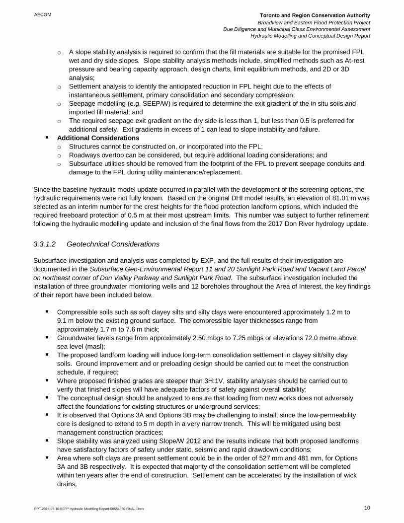
3.4.1 Floodwall Design and Construction Considerations
The conceptual consideration prior to commencement of this Project assumed that the structure would be a sheet
pile wall with a limited below grade footprint, which could be accommodated between the edge of the DVP and the
BMW building. Separate to this project, AECOM has developed Flood Protection Land Forming Technical Design
Considerations prepared for TRCA and has completed an extensive literature review of flood protection structure
design manuals. The preferred method for construction of modern floodwalls requires a cantilevered keyed footing
(see Exhibit 1) to prevent slippage and rotational failure. Unlike a sheet pile wall, which can be driven into the
AECOM Toronto and Region Conservation Authority
Broadview and Eastern Flood Protection Project
Due Diligence and Municipal Class Environmental Assessment
Hydraulic Modelling and Conceptual Design Report
RPT-2019-09-16-BEFP Hydraulic Modelling Report-60554370-FINAL.Docx 13
ground, a cantilevered wall would require sufficient excavation to accommodate the footings. The BMW building is
approximately 10 m away from the edge of the DVP at the closest point and there is likely insufficient room to
properly excavate for cantilevered footings. The structure would also have to be designed to consider the close
proximity of the DVP and would require a minimum clear zone of 5 m.
Exhibit 1: Example Sketch of Inverted T-type Floodwall-levee
As also described in Section 3.3.1.1 for the flood protection landform options, an interim elevation of 81.01 m was
selected for the top of the flood protection structure options, which included the required freeboard protection of 0.5
m at their most upstream limits. This number was further refinement with variable crest elevations following the
hydraulic modelling update and inclusion of the final flows from the 2017 Don River hydrology update.
3.4.2 Option 4A Floodwall
The Option 4A floodwall would retain the Mini dealerships and would tie-in to STA 0+180 of the Eastern Ave. ramp
to the DVP. The conceptual plan drawing for Option 4A is shown on Figure 3.7.
This option would require the vertical alignment of both Eastern Ave. and the Eastern Ave. ramp to the DVP to be
raised by approximately 2.8 m to facilitate the tie-in to the wall and would isolate the BMW dealership through
removal of the entranceways, leaving the structure unprotected from floodwaters. A retaining wall would also be
required to accommodate the vertical re-alignment of the roads.
The wall dimensions and footing depth for this option is subject to further geotechnical and structural analysis.
AECOM Toronto and Region Conservation Authority
Broadview and Eastern Flood Protection Project
Due Diligence and Municipal Class Environmental Assessment
Hydraulic Modelling and Conceptual Design Report
RPT-2019-09-16-BEFP Hydraulic Modelling Report-60554370-FINAL.Docx 14
3.4.3 Option 4B Floodwall
The Option 4B floodwall would retain the BMW and Mini dealerships and would tie-in to STA 0+180 of the Eastern
Ave. ramp to the DVP. The conceptual plan drawing for Option 4B is shown on Figure 3.8.
This option would require the vertical alignment of both Eastern Ave. and the Eastern Ave. ramp to the DVP to be
raised to facilitate the tie-in to the wall. A retaining wall would also be required to accommodate the vertical re-
alignment of the roads.
The wall dimensions and footing depth for this option is subject to further geotechnical and structural analysis.
3.4.4 Option 4C Floodwall
The Option 4C floodwall would retain the BMW and Mini dealerships and remove the Eastern Ave. ramp to the
DVP. The conceptual plan drawing for Option 4C is shown on Figure 3.9.
The wall dimensions and footing depth for this option is subject to further geotechnical and structural analysis.
This conceptual design intersects the Don and Central Waterfront Project, and further consideration of this
constraint would need to be addressed if this option is carried forward.
3.4.5 Option 4D Flood Protection Berm
The Option 4D Flood Protection Berm would remove the Mini dealership and would tie-in to STA 0+110 of the
Eastern Ave. ramp to the DVP. The conceptual plan and profile drawings for Option 4D are shown on Figures 3.10
and 3.11.
This option requires the vertical alignment of both Eastern Ave. and the Eastern Ave. ramp to the DVP to be raised
to facilitate the tie-in to the berm. A retaining wall would also be required to accommodate the vertical re-alignment
of the roads.
An additional alignment of this option is also illustrated on the drawings, which intersects with the East Harbour Go
Station electrification paralleling station and further consideration of this constraint would need to be addressed if
this option is carried forward.
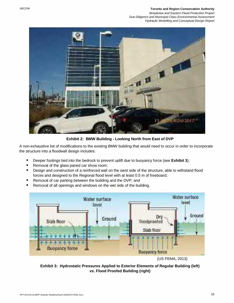
3.4.6 Option 4E Floodwall & Building Flood Proofing
Another alternative being considered under Option 4 is to incorporate the BMW building into the floodwall design.
A detailed assessment has not been completed of the as-builts or the interior of the structure and descriptions of
the BMW building are based on observations made during a site visit on November 28, 2017. A portion of the
existing BMW structure includes an open concept, glass paned car show room, which protrudes from the building
towards the DVP (see Exhibit 2). The remaining portion of the building appears to be decorative concrete
panelling. The building was likely constructed with a slab on grade foundation. The structure appears to be
approximately 20 m tall (6 stories).
AECOM Toronto and Region Conservation Authority
Broadview and Eastern Flood Protection Project
Due Diligence and Municipal Class Environmental Assessment
Hydraulic Modelling and Conceptual Design Report
RPT-2019-09-16-BEFP Hydraulic Modelling Report-60554370-FINAL.Docx 15
Exhibit 2: BMW Building - Looking North from East of DVP
A non-exhaustive list of modifications to the existing BMW building that would need to occur in order to incorporate
the structure into a floodwall design includes:
▪ Deeper footings tied into the bedrock to prevent uplift due to buoyancy force (see Exhibit 3);
▪ Removal of the glass paned car show room;
▪ Design and construction of a reinforced wall on the west side of the structure, able to withstand flood
forces and designed to the Regional flood level with at least 0.5 m of freeboard;
▪ Removal of car parking between the building and the DVP; and
▪ Removal of all openings and windows on the wet side of the building.
(US FEMA, 2013)
Exhibit 3: Hydrostatic Pressures Applied to Exterior Elements of Regular Building (left)
vs. Flood Proofed Building (right)

AECOM Toronto and Region Conservation Authority
Broadview and Eastern Flood Protection Project
Due Diligence and Municipal Class Environmental Assessment
Hydraulic Modelling and Conceptual Design Report
RPT-2019-09-16-BEFP Hydraulic Modelling Report-60554370-FINAL.Docx 16
The removal and rebuilding of the existing building with the appropriate specifications may be cheaper /
easier which would undermine the benefits of this option.
3.5 Operation & Maintenance Considerations
A previously noted, AECOM has developed the Flood Protection Land Forming Technical Design Considerations
prepared for TRCA. The general FPL operation and maintenance requirements are summarized below.
▪ An Operations, Maintenance and Monitoring Manual should be prepared for the FPL;
▪ Monthly monitoring and maintenance should occur during the summer months to maintain plantings,
and detect and remove the occurrence of animal burrows, invasive vegetation, and debris;
o Animal burrows can pose a substantial risk to the FPL through the exacerbation of seepage conduits
and shortening of the flow travel distance between the wet and dry sides.
▪ Ongoing survivability of plantings and vegetation should be monitored to ensure continued erosion
control. Dead or toppled vegetation should be replaced, and holes left by root balls should be filled;
▪ Maintenance inspections following construction of the FPL should monitor for the appearance of cracks
and fissuring, slumping, and surface scour due to concentrated runoff and high water events; and
▪ Settlement and seepage monitoring should be completed following construction.
The general operation and maintenance requirements for the floodwall or in combination with a retrofitted BMW
building are summarized below.
▪ Design life of 75 years;
▪ Visual inspections occurring every 2 years;
▪ Enhanced visual inspection/condition survey occurring every 5 years; and
▪ Wall repair in years 40 and 60.
Both the flood protection landform and flood protection structure options would need to be either owned or
accessible by TRCA through property expropriation or an easement agreement to ensure continued operation and
maintenance. This also assumes that there is a continued entity (e.g. TRCA) maintaining the structure. The size
and indefinite service life of the flood protection landform options provide the added benefit of providing some level
of flood protection if maintenance initiatives were to cease.
3.6 Initial Screening of Options
3.6.1 Initial Screening of Options
A preliminary qualitative/quasi-quantifiable technical review of the options being considered was completed to
screen out options, which are technically unfeasible or provided limited to no benefit.
The Flood Protection Landform options (3A, 3B, 3Bi) provide the most desirable protection due to their indefinite
service life and benefit of removing the floodplain from Special Policy Areas.
The Flood Protection Structure options (4A, 4B, 4C, 4D, 4E) have considerable technical challenges which could
ultimately prove to be unfeasible due to the limited space for excavation for a cantilevered flood wall between the
BMW building and the DVP, or the significant modifications required to incorporate the existing BMW building into
the floodwall design. These options have a fixed service life and would require ongoing structural repair. In
addition these options would not be considered for removal of the floodplain from the Special Policy Area.

AECOM Toronto and Region Conservation Authority
Broadview and Eastern Flood Protection Project
Due Diligence and Municipal Class Environmental Assessment
Hydraulic Modelling and Conceptual Design Report
RPT-2019-09-16-BEFP Hydraulic Modelling Report-60554370-FINAL.Docx 17
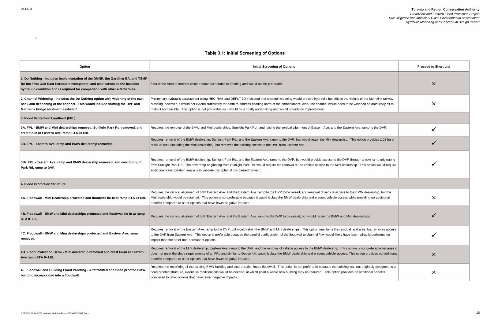
The initial screening of options is summarized in Table 3.1.
Due to the technical constraints and limited benefits of the options below, the Project Team recommended that they
not be carried forward to the short list of options for refinement.
▪ Option 1 – Do Nothing: Includes implementation of the DMNP, the Gardiner EA, and TSMP for the
First Gulf East Harbour development;
▪ Option 2 – Channel Widening: Includes the Do Nothing option with widening of the east bank and
deepening of the channel. This would include shifting the DVP and Metrolinx bridge abutment
eastward;
▪ Option 3 – Flood Protection Structure:
o Option 4A Floodwall – Mini Dealership protected and floodwall tie-in at ramp STA 0+180;
o Option 4D Flood Protection Berm – Mini dealership removed and crest tie-in at Eastern Ave ramp STA
0+110; and
o Option 4E Floodwall & Building Flood Proofing – Includes a retrofitted and flood proofed BMW building
incorporated into a floodwall.
AECOM Toronto and Region Conservation Authority
Broadview and Eastern Flood Protection Project
Due Diligence and Municipal Class Environmental Assessment
Hydraulic Modelling and Conceptual Design Report
RPT-2019-10-04-BEFP Hydraulic Modelling Report-60554370-FINAL.Docx 18
o
Table 3.1: Initial Screening of Options
Option Initial Screening of Options Proceed to Short List
1. Do Nothing - Includes implementation of the DMNP, the Gardiner EA, and TSMP
for the First Gulf East Harbour development, and also serves as the baseline
hydraulic condition and is required for comparison with other alternatives.
8 ha of the Area of Interest would remain vulnerable to flooding and would not be preferable. ×
2. Channel Widening - Includes the Do Nothing option with widening of the east
bank and deepening of the channel. This would include shifting the DVP and
Metrolinx bridge abutment eastward.
Preliminary hydraulic assessment using HEC-RAS and DEFLT 3D indicated that channel widening would provide hydraulic benefits in the vicinity of the Metrolinx railway
crossing, however, it would not extend sufficiently far north to address flooding north of the embankment. Also, the channel would need to be widened so drastically as to
make it not feasible. This option is not preferable as it would be a costly undertaking and would provide no improvement.
×
3. Flood Protection Landform (FPL)
3A. FPL - BMW and Mini dealerships removed, Sunlight Park Rd. removed, and
crest tie-in at Eastern Ave. ramp STA 0+180.
Requires the removal of the BMW and Mini dealerships, Sunlight Park Rd., and raising the vertical alignment of Eastern Ave. and the Eastern Ave. ramp to the DVP.
✓
3B. FPL - Eastern Ave. ramp and BMW dealership removed.
Requires removal of the BMW dealership, Sunlight Park Rd., and the Eastern Ave. ramp to the DVP, but would retain the Mini dealership. This option provides 1.03 ha of
residual area (including the Mini dealership), but removes the existing access to the DVP from Eastern Ave.
✓
3Bi. FPL - Eastern Ave. ramp and BMW dealership removed, and new Sunlight
Park Rd. ramp to DVP.
Requires removal of the BMW dealership, Sunlight Park Rd., and the Eastern Ave. ramp to the DVP, but would provide access to the DVP through a new ramp originating
from Sunlight Park Rd. The new ramp originating from Sunlight Park Rd. would require the removal of the vehicle access to the Mini dealership. This option would require
additional transportation analysis to validate this option if it is carried forward.
✓
4. Flood Protection Structure
4A. Floodwall - Mini Dealership protected and floodwall tie-in at ramp STA 0+180.
Requires the vertical alignment of both Eastern Ave. and the Eastern Ave. ramp to the DVP to be raised, and removal of vehicle access to the BMW dealership, but the
Mini dealership would be retained. This option is not preferable because it would isolate the BMW dealership and prevent vehicle access while providing no additional
benefits compared to other options that have fewer negative impacts.
×
4B. Floodwall - BMW and Mini dealerships protected and floodwall tie-in at ramp
STA 0+180. Requires the vertical alignment of both Eastern Ave. and the Eastern Ave. ramp to the DVP to be raised, but would retain the BMW and Mini dealerships. ✓
4C. Floodwall - BMW and Mini dealerships protected and Eastern Ave. ramp
removed.
Requires removal of the Eastern Ave. ramp to the DVP, but would retain the BMW and Mini dealerships. This option maintains the residual land area, but removes access
to the DVP from Eastern Ave. This option is preferable because the parallel configuration of the floodwall to channel flow would likely have less hydraulic performance
impact than the other non-permanent options.
✓
4D. Flood Protection Berm - Mini dealership removed and crest tie-in at Eastern
Ave ramp STA 0+110.
Requires removal of the Mini dealership, Eastern Ave. ramp to the DVP, and the removal of vehicle access to the BMW dealership. This option is not preferable because it
does not meet the slope requirements of an FPL and similar to Option 4A, would isolate the BMW dealership and prevent vehicle access. This option provides no additional
benefits compared to other options that have fewer negative impacts.
×
4E. Floodwall and Building Flood Proofing - A retrofitted and flood proofed BMW
building incorporated into a floodwall.
Requires the retrofitting of the existing BMW building and incorporation into a floodwall. This option is not preferable because the building was not originally designed as a
flood proofed structure, extensive modifications would be needed, at which point a whole new building may be required. This option provides no additional benefits
compared to other options that have fewer negative impacts.
×
AECOM Toronto and Region Conservation Authority
Broadview and Eastern Flood Protection Project
Due Diligence and Municipal Class Environmental Assessment
Hydraulic Modelling and Conceptual Design Report
RPT-2019-09-16-BEFP Hydraulic Modelling Report-60554370-FINAL.Docx 19
4. Refinement of Short Listed Options – Stage 2
Through the screening process (Section 3) four short listed options were selected for further refinement and
hydraulic validation in Stage 2. They are listed below:
• Option 3A Flood Protection Landform (FPL) – BMW and Mini dealerships removed, Sunlight Park Rd.
removed, and crest tie-in at Eastern Ave. ramp STA 0+180;
• Option 3B Flood Protection Landform (FPL) – Eastern Ave. ramp and BMW dealership removed;
• Option 3Bi Flood Protection Landform (FPL) – Eastern Ave. ramp and BMW dealership removed, and
new Sunlight Park Rd. ramp to DVP
• Option 4B Floodwall - BMW and Mini dealerships protected and floodwall tie-in at ramp STA 0+180.
• Option 4C Floodwall – BMW and Mini dealerships protected, and Eastern Ave. ramp removed.
4.1 Design Considerations and Geometry Refinement
The grading of the FPL options were refined by conducting additional hydraulic scour and geotechnical analysis.
The following sections describe the scour analysis and geotechnical seepage analysis in more detail.
4.1.1 FPL Dry Side Scour Analysis
The FPL dry side scour analysis to justify using 3.5% slope vs 1.5% slope was performed by TRCA. The FPL was
forced to overtop at 115%, 120%, and 130% Regional flow. The 115% model run showed minor overtopping at low
velocities so that case wasn't analyzed further. As expected, the 1.5% slope FPL had generally lower velocities in
the 120% scenario. However, in the 130% scenario the area extent of erosive flows (>1.2 m/s) is greater with 1.5%
slope. Perhaps this might be because the 3.5% scenario is more efficient at passing flows over the crest, so it takes
a wider spill area to pass the same flow with 1.5% slopes. To fully protect a FPL from the overtopping mode of
failure, where erosive flows scour the dry side of the FPL when overtopped, it may be appropriate to armor the dry
side slopes in select areas. Based on these early model runs, the top and bottom third of a 3.5% slope can be
armored armored with something like buried stone sized to resist design flow rates. This design consideration can
be fleshed out in detailed design. The conclusion of the analysis is that 3.5% dry side slopes is suitable for the
BEFP FPL’s. Detail analysis is provided in Appendix B.
4.1.2 Seepage Analysis
Steady-state seepage analysis was performed on one cross section for the proposed FPL (Stage 2 Option 3B –
3.5% dry side slope) to assess the seepage potential through the structure and verify the feasibility of the proposed
FPL. A memorandum of Seepage Analysis is provided in Appendix C of this report and results summary are
presented below here.
Case Scenario:
The seepage analysis was performed for the following case scenario:
▪ Steady-state condition wherein water level remains at normal stage from 0:00AM to 2:00AM. In our
case, it is 74.5 masl for Don River (TRCA, 2018);

AECOM Toronto and Region Conservation Authority
Broadview and Eastern Flood Protection Project
Due Diligence and Municipal Class Environmental Assessment
Hydraulic Modelling and Conceptual Design Report
RPT-2019-09-16-BEFP Hydraulic Modelling Report-60554370-FINAL.Docx 20
▪ During flooding, water level rises to 79.9 masl (i.e. 0.5 m below the top of crest) from 2:00AM to
4:00AM, remains at this level for another two hours (Ontario Realty Corporation, 2006);
▪ The water level drops back to normal water level in the next 12 hours (Ontario Realty Corporation,
2006).
The assumed design criterion is that the groundwater table on the dry side of the landform should not rise above
existing grades.
Exit Gradient:
The exit gradient is typically calculated by dividing the total head loss between two particular nodes by the elevation
difference between the nodes. SEEP/W provides exit gradient values under different conditions in addition to
evaluating the seepage quantity. The USACE guidance for exit gradients under various seepage conditions in
presented in Table 4.1.
Table 4.1: USACE Guidance for Exit Gradients
Exit Gradient (i) Seepage Condition
0.0 to 0.5 None to Light Seepage
0.2 to 0.6 Medium Seepage
0.4 to 0.7 Heavy Seepage
0.5 to 0.8 Sand Boils
In general, USACE guidance document mentions that seepage gradient on the landside should not exceed 0.5.
Results:
The seepage analysis was performed for the above mentioned scenario. The output results are presented in the
preliminary seepage analysis memorandum (Appendix C), the calculated flow quantities and exit gradient results
are presented in Table 4.2.
Table 4.2: Calculated Flow Quantities and Exist Gradients
Seepage Condition
Seepage Location
Sta 40+00 Sta 80+00 Sta 120+00
Cumulative Flow
(m3/hr)
Exit
Gradient
Cumulative Flow
(m3/hr)
Exit
Gradient
Cumulative Flow
(m3/hr)
Exit
Gradient
Steady-State
Condition (0-2 hrs) 0.00024 0.00002 0.0004 0.001 0.000238 0.00006
Flood Condition
(2-4 hrs) 0.00024 <0 0.002 0.008 0.0015 0.0001
Rapid Drawdown
Condition (4.3 hrs) 0.00003 0.08 0.0014 0.008 0.0015 0.00006
Rapid Drawdown
Condition (4.8 hrs) 0.00066 0.0007 0.00127 0.006 0.0015 0.00006
Rapid Drawdown
Condition (6.1 hrs) 0.0013 <0 0.0009 <0 0.0015 0.00006
Rapid Drawdown
Condition (9.1 hrs) 0.0014 <0 0.0006 <0 0.0015 0.00006
Rapid Drawdown
Condition (16 hrs) 0.0011 <0 0.0004 <0 0.0015 0.00006

AECOM Toronto and Region Conservation Authority
Broadview and Eastern Flood Protection Project
Due Diligence and Municipal Class Environmental Assessment
Hydraulic Modelling and Conceptual Design Report
RPT-2019-09-16-BEFP Hydraulic Modelling Report-60554370-FINAL.Docx 21
The exit gradient that was calculated from SEEP/W analysis at three stations is 0.1 or less for the case scenario
presented above. The maximum value found is 0.08 at Station 40+00 during the rapid drawdown condition.
The results from above preliminary analysis indicate that the exit gradient at these locations meets the USACE
guidance criteria, therefore there is no potential for catastrophic failure of the FPL due to seepage through the
structure during a Regulatory Storm event. However, as indicated above, these results are only preliminary and
further analysis has to be carried out during detailed design stage, to properly assess seepage conditions, when
further subsurface information becomes available.
4.1.3 FPL Grading Refinement
The results of the hydraulic scour and seepage analysis concluded that dry side slopes can be generally steepened
from 1.5% to 3.5%. With the new FPL grading scheme the study team discovered it was possible to accommodate
the Eastern Ave on-ramp over FPL Option 3B. This meant that Option 3Bi became redundant because the on-ramp
can be accommodated without impacts to vehicular traffic. Option 3A similarly became redundant because the
Eastern Ave on-ramp can be accommodated without removing the Mini Dealership. Therefore, all three FPL options
were combined to a single option – FPL Option 3R (Figure 4.1 – 4.5).
4.2 Hydraulic Validation of Short Listed Options
Following completion of the revised baseline model, the short listed options were hydraulically modelled in 2D.
Scenarios for the short listed options 3R, 4B and 4C were created in MIKE 21 using the updated baseline model for
comparison. A summary of this hydraulic assessment is provided in Table 4.3.
For the flood protection landform options 3R, a consolidated surface was prepared using the updated baseline
surface and the FPL geometry for use in the hydraulic model. In addition to this update, the BMW building was
removed from the 2D mesh in Option 3R.
For flood protection structure option 4B, a new dike was modelled west of the BMW building between the raised
Eastern Ave. and ramp and the Metrolinx rail bridge, with a total length of approximately 393 m. Various crest
elevations (representing the top of wall) from 81.06 m to 79.89 m were tested for the new Option 4B dike. For
the Option 4C, a new dike was modelled west of the BMW building between Eastern Ave. and the Metrolinx rail
bridge, with a total length of approximately 373 m, Various crest elevations from 80.58 m to 79.89 m (North to
South) were tested for the new Option 4C dike.
Table 4.3: Summary of MIKE 21 Modeling Scenarios
Option Crest Elevation of FPL/Floodwall (m) WSE (m) Free Board (m)
Upstream Downstream Upstream Downstream Upstream Downstream
Baseline 79.84 78.89
3R 80.47 79.59 79.97 78.73 0.50 0.86
4B 81.06 79.89 80.06 78.84 1.00 1.05
4C 80.58 79.89 80.08 78.73 0.50 1.16
4.2.1 Option 3R
The modelled Regional water surface elevations (WSE) are shown in Figure 4.6. The WSE at the upstream and
downstream limit of the FPL are approximately 79.94 and 78.72 m. The crest elevation at the upstream and
AECOM Toronto and Region Conservation Authority
Broadview and Eastern Flood Protection Project
Due Diligence and Municipal Class Environmental Assessment
Hydraulic Modelling and Conceptual Design Report
RPT-2019-09-16-BEFP Hydraulic Modelling Report-60554370-FINAL.Docx 22
downstream limit of the conceptual FPL are approximately 80.47 and 79.59 m. Compare to the updated baseline
Regional storm event results, the WSE increased by approximately 0.1 – 0.2 m at upstream limit of the FPL.
However, the crest of the conceptual FPL would not be overtopped during the Regional storm and the required
freeboard of 0.5 m would be met.
Comparison results to the updated baseline Regional depth are shown in Figure 4.7. The Regional depth
comparison results predict that the introduction of the Option 3R FPL would decrease the flood depth along the
downstream portion of the main channel by approximately 0.1 to 0.4 m. The areas encompassed by the Eastern
Ave. ramp to the DVP, and the area behind the rail embankment on the west bank of the Don are predicted by the
model to have an increase in depth of approximately 0 to 0.4 m for the Regional storm. The area upstream of the
FPL to the top of the model at Gerrard St. E is predicted by the model to have an increase in depth by
approximately 0 – 0.2 m for the Regional storm. This may be boundary effects causing fluctuations in water
elevations, especially near the upstream end of the model. It is recommended to extend the upstream end of the
model for detail design. Also, most of the depth increases are below 10 cm, which is within model tolerances.
Comparison results to the updated baseline Regional velocity predict a general increase in velocity of
approximately 0.01 to 0.75 m/s along the east and west banks of the Don River, as shown in Figure 4.8. The area
encompassed by the Eastern Ave. ramp to the DVP and the west pier of the Metrolinx rail bridge are predicted by
the model to have a decrease in Regional velocity of approximately 0 to 0.5 m/s.
Comparison results to the updated baseline Regional flood risk are illustrated in Figure 4.9. The Regional flood risk
was generally no change within the modelled area, while a High to Low flood risk change was predicted along to
the Option 3R FPL Low to High and Low to Medium flood risk changes were predicted along Metrolinx rail and
West Don Lands FPL, respectively, on the west bank of the Don River close to the Metrolinx bridge. The change in
risk areas are localized, and the increased risk is low. Therefore, mitigation is not required.
Comparison results to the updated baseline 350-year depth, velocity and flood risk are shown in Figure 4.10, 4.11
and 4.12. Generally, the depth and velocity increases would be minimal (within 0.1 m for depth, 0.1 m/s for
velocity). The flood risk was generally no change within the whole modelled area.
4.2.2 Option 4B
The modelled Regional WSE is shown in Figure 4.13. The Regional WSE at the upstream and downstream limit of
the floodwall are approximately 80.06 and 78.84 m. The crest elevation at the upstream and downstream limit of
the conceptual floodwall are approximately 81.1 and 79.89 m. The Regional WSE elevation increased by
approximately 0.15 m adjacent to the West of floodwall. However, the crest of the conceptual floodwall would not
be overtopped during the Regional storm and the required freeboard would be met.
Comparison results to the updated baseline Regional depth are shown in Figures 4.14. The Regional depth
comparison results predict that the introduction of the Option 4B floodwall would decrease the depth in the
downstream portion of the main channel by approximately 0.1 to 0.35 m. The area upstream of the floodwall to the
top of the model at Gerrard St. E is predicted by the model to have an increase in depth by approximately 0 – 0.2 m
for the Regional storm. This may be boundary effects causing fluctuations in water elevations, especially near the
upstream end of the model. It is recommended to extend the upstream end of the model for detail design. Also,
most of the depth increases are below 10 cm, which is within model tolerances.
Comparison results to the updated baseline Regional flood risk are illustrated in Figure 4.15. The Regional flood
risk was generally no change within the modelled area. However, small section of Low to High and Low to Medium
flood risk changes were predicted at north of ramp. Low to High and Low to Medium flood risk changes were
predicted at small section of Metrolinx rail, on the west bank of the Don River close to the Metrolinx bridge. This is
not the critical area, mitigation is not required
AECOM Toronto and Region Conservation Authority
Broadview and Eastern Flood Protection Project
Due Diligence and Municipal Class Environmental Assessment
Hydraulic Modelling and Conceptual Design Report
RPT-2019-09-16-BEFP Hydraulic Modelling Report-60554370-FINAL.Docx 23
Comparison results to the updated baseline 350-year depth is shown in Figure 4.16. Generally, the depth
increases would be minimal (within 0.1 m) in the modelled area.
4.2.3 Option 4C
The modelled Regional WSE is shown in Figure 4-17. The Regional WSE at the upstream and downstream limit of
the floodwall are approximately 80.08 and 78.73 m. The crest elevation at the upstream and downstream limit of
the floodwall are approximately 80.58 and 79.89 m. Based on the hydraulic analysis, the crest of the conceptual
floodwall would not be overtopped during the Regional storm and the required freeboard would be met.
Comparison results to the updated baseline Regional depth are shown in Figure 4.18. The Regional depth
comparison results predict that the introduction of the Option 4C floodwall would decrease the depth in the
downstream portion of the main channel by approximately 0 to 0.1 m. The area behind the rail embankment on the
west bank of the Don is predicted by the model to have an increase in depth of approximately 0 to 0.25 m for the
Regional storm. The area upstream of the floodwall to the top of the model at Gerrard St. E is predicted by the
model to have an increase in depth by approximately 0 – 0.2 m for the Regional storm.
Comparison results to the updated baseline Regional flood risk are illustrated in Figure 4.19. The Regional flood
risk was generally no change within the modelled area. However, a few spots of Low to Medium flood risk changes
were predicted at north of Eastern Avenue. Low to High and Low to Medium flood risk changes were predicted at
small section of Metrolinx rail on the west bank of the Don River close to the Metrolinx bridge. The change in risk
areas are localized, and the increased risk is low. Therefore, mitigation is not required.
Comparison results to the updated baseline 350-year depth is shown in Figure 4.20. Generally, the depth
increases would be minimal (within 0.1 m) in the modelled area.

AECOM Toronto and Region Conservation Authority
Broadview and Eastern Flood Protection Project
Due Diligence and Municipal Class Environmental Assessment
Hydraulic Modelling and Conceptual Design Report
RPT-2019-09-16-BEFP Hydraulic Modelling Report-60554370-FINAL.Docx 24
5. Conclusion and Recommendations
The purpose of the Broadview and Eastern Flood Protection Project Due Diligence and Municipal Class
Environmental Assessment (EA) is to recommend a flood protection solution that will (1) address flood risk up to
and including the Regulatory Flood event to the 8 ha of land north of the Metrolinx railway embankment east of the
Don River; (2) not increase flood risk elsewhere; and (3) integrate with concurrent planning and infrastructure plans
in the area.
Four primary conceptual option categories were developed for the project and the pre-screened list of conceptual
options is identified below.
▪ Option 1 – Do Nothing: Includes implementation of the DMNP, the Gardiner EA, and TSMP for the
First Gulf East Harbour development;
▪ Option 2 – Channel Widening: Includes the Do Nothing option with widening of the east bank and
deepening of the channel. This would include shifting the DVP and Metrolinx bridge abutment
eastward;
▪ Option 3 – Flood Protection Landform:
o Option 3A FPL – BMW and Mini dealerships removed, Sunlight Park Rd. removed, and crest tie-in
at Eastern Ave. ramp STA 0+180;
o Option 3B FPL – Eastern Ave. ramp and BMW dealership removed; and
o Option 3Bi FPL – Eastern Ave. ramp and BMW dealership removed, and new Sunlight Park Rd.
ramp to DVP.
▪ Option 4 – Flood Protection Structure:
o Option 4A Floodwall – Mini Dealership protected and floodwall tie-in at ramp STA 0+180;
o Option 4B Floodwall – BMW and Mini dealerships protected and floodwall tie-in at ramp STA
0+180;
o Option 4C Floodwall – BMW and Mini dealerships protected and Eastern Ave. ramp removed;
o Option 4D Flood Protection Berm – Mini dealership removed and crest tie-in at Eastern Ave ramp
STA 0+110; and
o Option 4E Floodwall & Building Flood Proofing – A retrofitted and flood proofed BMW building
incorporated into a floodwall.
A preliminary qualitative/quasi-quantifiable technical review of the options being considered was completed to
screen out options, which are technically unfeasible or provided limited to no benefit. Of the ten options that were
evaluated, six were deemed technically unfeasible or provided limited to no benefit. The remaining short listed
options are identified below:
▪ Option 3 – Flood Protection Landform:
o Option 3A FPL – BMW and Mini dealerships removed, Sunlight Park Rd. removed, and crest tie-in
at Eastern Ave. ramp STA 0+180;
o Option 3B FPL – Eastern Ave. ramp and BMW dealership removed; and
o Option 3Bi FPL – Eastern Ave. ramp and BMW dealership removed, and new Sunlight Park Rd.
ramp to DVP.
▪ Option 4 – Flood Protection Structure:
o Option 4B Floodwall - BMW and Mini dealerships protected and floodwall tie-in at ramp STA
0+180;
o Option 4C Floodwall – BMW and Mini dealerships protected and Eastern Ave. ramp removed.
AECOM Toronto and Region Conservation Authority
Broadview and Eastern Flood Protection Project
Due Diligence and Municipal Class Environmental Assessment
Hydraulic Modelling and Conceptual Design Report
RPT-2019-09-16-BEFP Hydraulic Modelling Report-60554370-FINAL.Docx 25
The FPL dry side scour analysis and seepage analysis were performed to confirm the design consideration and
geometry refinement. The FPL dry side scour analysis conclude that 3.5% dry side slopes is suitable for the BEFP
FPL’s. Results of seepage analysis indicate that no potential for catastrophic failure of the FPL due to seepage
through the structure during a Regulatory Storm event. However, seepage analysis results are only preliminary and
further analysis has to be carried out during detailed design stage, to properly assess seepage conditions, when
further subsurface information becomes available. Based on this analysis the FPL options were refined and through
that process the three FPL options were merged into one.
The short listed options were subject to 2D hydraulic validation in MIKE 21 using the baseline model developed by
DHI and updated by AECOM for the lower Don River in Stage 2. The updated baseline model represents a
consolidation of both existing conditions and approved future projects, which include the Don Mouth Naturalization
and Port Lands Flood Protection Project (DMNP) and the Transportation Servicing Master Plan (TSMP) for the Port
Lands and South of Eastern Area, which considers the future First Gulf East Harbour development and the
southern extension of Broadview Avenue. The latest Steady State Regional Flow of 1,560 m3/s from the 2017 Don
Hydrology Update was utilized for the revised baseline model and four short listed options in Stage 2.
The results of the hydraulic validation predict that none of the short listed options would be overtopped during the
Regional storm event. The freeboard criterion of 0.5 m (including 0.2 m contingency for climate change) was met
for all three (3R, 4B and 4C) short listed Options. Flood risk was not changed in the short listed options, with the
exception of localized areas.
The results from the hydraulic validation suggest that Options 3R provide the best hydraulic performance and
minimizes impacts to infrastructure and private property. This option has the least impact to water surface
elevation and depth but would require removal of the BMW dealership. Therefore, the preferred option is Option 3R
(Figure 4.1 – 4.5). This keeps the FPL on the western most edge of the project site which it allows it to be as little
land consumptive as possible while also allowing the Eastern Avenue on ramp (access to the DVP) to remain (to be
rebuilt in place). Dillon Consulting is preparing in parallel with this report, the Broadview and Eastern Flood
Protection Project Class EA Screening Report, which will further evaluate the four short listed options based on
Technical, Social, Environmental, and Financial criteria.
Next Step:
In detail design, update the 2D model (Mike 21) based on the final FPL design and extend the upstream end of
modeling boundary is recommended.
The seepage model is also recommended to be updated accordingly to the final layout of the FPL to verify
the exit gradient and confirm no potential for catastrophic failure during a Regulatory Storm event.
AECOM Toronto and Region Conservation Authority
Broadview and Eastern Flood Protection Project
Due Diligence and Municipal Class Environmental Assessment
Hydraulic Modelling and Conceptual Design Report
RPT-2019-09-16-BEFP Hydraulic Modelling Report-60554370-FINAL.Docx 26
6. References
Danish Hydraulic Institute (DHI). (2017). Don Mouth MIKE FLOOD Modelling and Analysis Project. Dillon Consulting. (2005). Lower Don River West Remedial Flood Protection Project Class Environmental
Assessment Environmental Study Report.
Dillon Consulting. (2018). Broadview and Eastern Flood Protection Project Draft Screening Report.
EXP Services Inc. (2018). Subsurface Geo-Environmental Report 11 and 20 Sunlight Park Road and Vacant Land
Parcel on Northeast Corner of Don Valley Parkway and Sunlight Park Road.
Ministry of Natural Resources and Forestry (MNRF). (2002). Technical Guide - River and Stream Systems: Flood
Hazard Limit.
US Army Corps of Engineers. (2000). Engineering and Design: Design and Construction of Levees (EM 1110-2-
1913).
US Army Corps of Engineers, CIRIA, and French Ministry of Ecology. (2013). The International Levee Handbook.
US Federal Emergency Management Agency (FEMA). (2013). Floodproofing Non-Residential Buildings.

COLGATE AVE
CLARK STKINTYRE AVE
THOMPSON ST
LABATT AVE
CARROLL ST
JUNE CALLWOODWAY
GRANT ST
BASIN STCOLGATE AVE
MUNITION ST
ST LAWRENCE ST
HAMILTON ST
LAWRE N HARRIS SQ
HAMILTON ST
WASCANA AVE
MATILDA ST
BISLEY ST
SAULTER ST
BAY V
I EWAV
EGRAHAM PL
CARROLL ST
BOOTH AVE
BUSY ST
MARK ST
MILL ST
DONMOUNT CRT
MUNRO ST
LOWER RIVER ST
WASCANA AVE
EMPIRE AVE
JUNE CALLWOOD WAY
OLD BREWERY LANE
BOULTON AVE
MCGEE ST
FEE PL
LEWIS ST
BOOTH AVE
MILL ST
DE GRASSI ST
WOODG
REEN
PL
TANNERY RD
TANNERY RD
ROLLINGMILLS RD
STRANGE ST
EASTERN AVE
PERCY ST
DAVIES AVE
DIBBLE ST
PALACE ST
MUNRO ST
TROLLEY CRES
DEFRIES ST
SUNLIGHT PARK RD
SAULTER ST S
MUNRO ST
KINTYRE AVE
BOOTH AVE
DISTILLERY L A NEBOUCHETTE ST
EDON RDWY
WARD
ELLS
T
HOWIE AVE
ROLLING MILLS RD
COOPERAGE ST
VILLIERS STVILLIERS ST
VILLIERS ST
QUEEN ST E
BROADVIEW AVE
EASTERN AVE
CHERRY ST
DON VALLEY PKY
KING ST E
DUNDAS ST E
BAYVIEWAVE
DON RDWY
CHERRY ST
RIVER ST
CHERRY ST
LAKE SHORE BLVD E
LOGAN AVE
LAKE SHORE BLVD E
FRONT ST E
EASTERN AVE
EASTERN AVE
LAKE SHORE BLVD E
CHERRY STCOMMISSIONERS ST
DON RDWY
LAKE SHORE BLVD E
ADELAIDE ST E
EASTERN AVENUE DIVERS
RICHMOND ST E
EASTERN AVENUE DIVERS
EASTERN AVENUE DIVERS
EASTERN AVENUE DIVERS
EASTERN AVE. RAM
PEASTERN AVENUE
EASTERN AVENUE
EASTERN AVENUE
EASTERN AVENUE
DON VALLEY PKY
DON VALLEY PKY
F G GARDINER EXPYF G GARDINER EXPY
Keating Channel
West Don Lands
Flood Protection Landform
Eastern
Ave. Ramp
Broadview Avenue
Extension and LRT
Don and Central
Waterfront Project
Future East HarbourDevelopment
Future East Harbour
Valley Wall
Future BroadviewAve. FPL
Future East
ern
Ave. FPLFuture ReliefLine Station
Future EastHarbour GO Station
Riverside Square Development(under Construction)
Future Gardiner Re-AlignmentFuture Don Mouth Naturalizationand Port Lands Flood Protection
Future GO TransitDon Yard Expansion
Sediment and DebrisManagement Area
HONI Utility
Bridge
Old Eastern Ave.
Bridge (Abandon)
Metrolinx
Rail Bridge
BMW
MINI
Lower Don River
m
0 100 200 30050Meters
Jul. 30, 2018 1:5,000
Figure 1.1
Study Area and Adjacent Projects
P#: 60554370 V#: 1.0
Datum: NAD83 UTM17Source: TRCA, LIO, Toronto
This drawing has been prepared for the use of AECOM's client and may not be used, reproduced or relied upon by third parties, except as agreed by AECOM and its client, as required by law or for use by governmental reviewing
agencies. AECOM accepts no responsibility, and denies any liability whatsoever, to any party that modifies this drawing without AECOM's express written consent.
N
Map l
ocati
on: T
:\Proj
ects\
6055
4370
- TRC
A BEF
P\90
0-Work
\920-9
29 (G
IS-G
raphic
s)\mx
d\rpt\
Stag
e 1\FI
G_1-1
_Stud
y Area
_605
5437
0_11
x17.m
xdDa
te Sa
ved:
7/30/2
018 1
:02:32
PM
Lake Ontario
YellowCreek
Lower Don River
BROADVIEW AVE
GERRARD ST E
EASTERN AVE
KING ST E
PARLIAMENT ST
YONGE ST
DANFORTHAVE
BAYVIEW AVE
LAKE SHORE BLVD E
³ LegendArea of InterestProperty Parcels
Note: Project location illustrations are approximate. Broadview and Eastern Flood ProtectionProject Class Environmental Assessment
Hydraulic Modelling and Conceptual Design Report
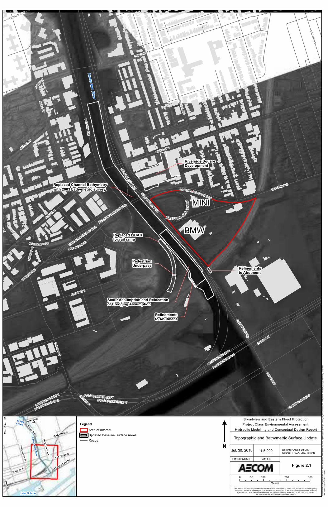
Replaced Channel Bathymetrywith 2003 bathymetric survey.
Replaced LiDARfor rail ramp
Scour Assumption and Relocationof Dredging Assumption
Riverside SquareDevelopment
Refinementsto Abutment
Refinementsto Abutment
PedestrianUnderpass
DUNDAS ST E
CHERRY ST
BROADVIEW AVE
EASTERN AVE
LOGAN AVE
EASTERN AVE
LAKE SHORE BLVD E
CHERRY ST
KING ST E
DON VALLEYPKY
BAYVIEWAVE
DON RDWY
RIVER ST
EASTERN AVENUE DIVERS
QUEEN ST E
LAKE SHORE BLVD E
LAKE SHORE BLVD E
GERRARD ST E
RIVER ST
EASTERN AVENUE DIVERS
COMMISSIONERS ST
SHUTER ST
FRONT ST E
LAKE SHORE BLVD E
DON RDWY
CHER
RYST ADELAIDE ST EEASTERN AVENUE DIVERS
RICHMOND ST E
EASTERN AVE.RA
MPDON VALLEY PKY
DON VALLEY PKY
F G GARDINER EXPYF G GARDINER EXPY
BMW
MINI
Lower Don River
m
0 100 200 30050Meters
Jul. 30, 2018 1:5,000
Figure 2.1
Broadview and Eastern Flood ProtectionProject Class Environmental Assessment
Hydraulic Modelling and Conceptual Design Report
Topographic and Bathymetric Surface Update
P#: 60554370 V#: 1.0
Datum: NAD83 UTM17Source: TRCA, LIO, Toronto
This drawing has been prepared for the use of AECOM's client and may not be used, reproduced or relied upon by third parties, except as agreed by AECOM and its client, as required by law or for use by governmental reviewing
agencies. AECOM accepts no responsibility, and denies any liability whatsoever, to any party that modifies this drawing without AECOM's express written consent.
N
Map l
ocati
on: T
:\Proj
ects\
6055
4370
- TRC
A BEF
P\90
0-Work
\920-9
29 (G
IS-G
raphic
s)\mx
d\rpt\
Stag
e 1\FI
G_2-1
_Top
ograp
hic an
d Bath
ymetr
ic Su
rvey U
pdate
_605
5437
0_11
x17.m
xdDa
te Sa
ved:
7/30/2
018 1
:02:49
PM
Lake Ontario
YellowCreek
Lower Don River
BROADVIEW AVE
GERRARD ST E
EASTERN AVE
KING ST E
PARLIAMENT ST
YONGE ST
DANFORTHAVE
BAYVIEW AVE
LAKE SHORE BLVD E
³ LegendArea of InterestUpdated Baseline Surface AreasRoads
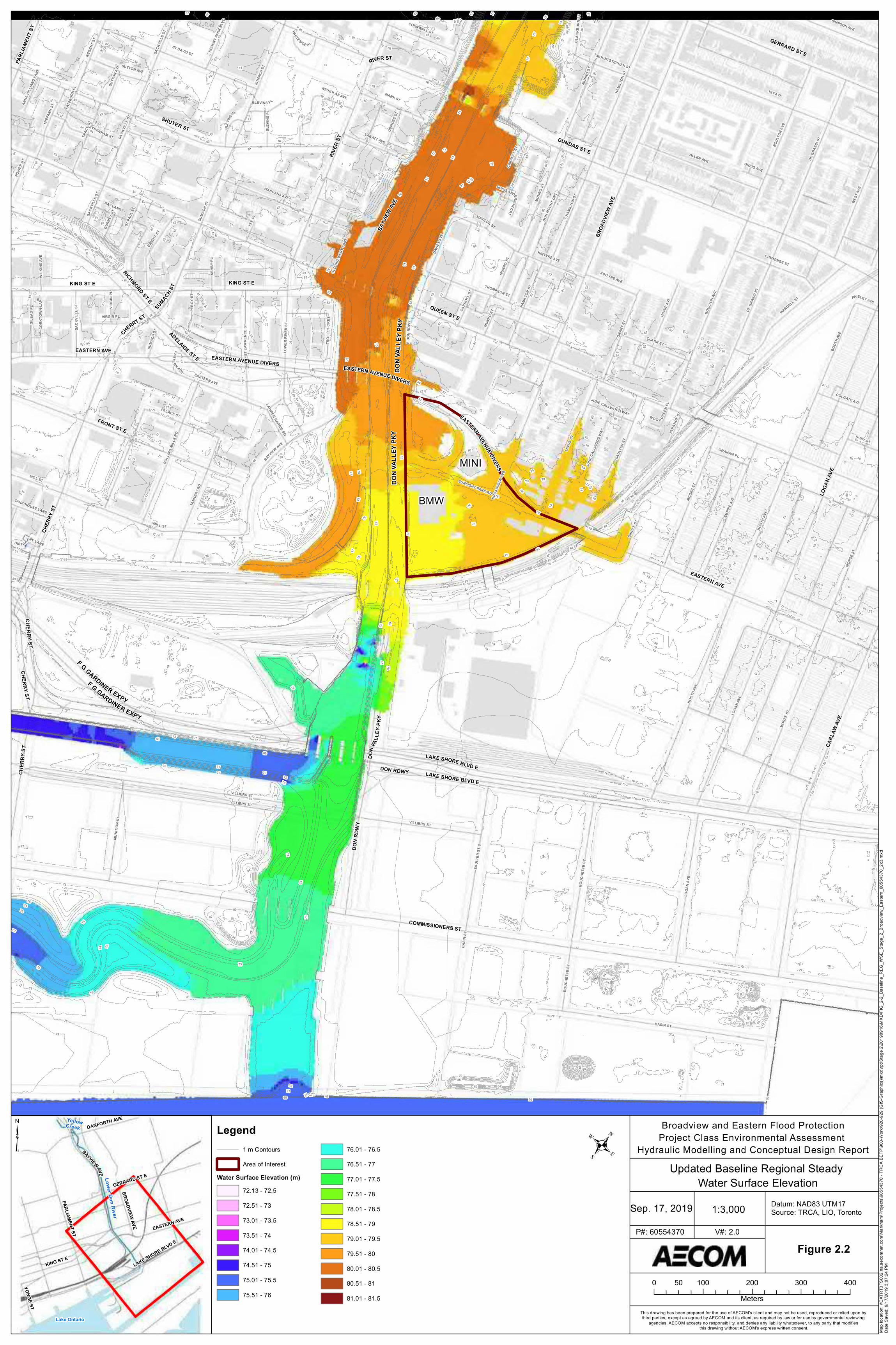
SACK
VILLE
ST
BRIGHT
ST
CLARK ST
PAISLEY AVE
KINTYRE AVE
THOMPSON ST
DORIS ANDERSONCRT
LABATT AVE
GREIG AVE
BOUL
TON A
VE
TANK HOUSE LANECA
RROL
L ST
JUNE
CALL
WOOD
WAY
GRAN
T ST
BASIN
ST
BASIN ST
REGE
NT ST
MOUNTSTEPHEN ST
MUNI
TION
ST
STLA
WR E
NCES
T
ASHB
Y PL
SYDENHAM ST
LAWREN HARRIS SQ
PATE
RSON
PL
BUSY ST
CUMMINGS ST
EASTERN AVE
HAMI
LTON
ST
GILE
AD P
L
MATILDA ST
SACK
VILLE
ST
MUNR
OST
HAMI
LTON
ST
TRAC
Y ST
SAUL
TER S
T
RAY LANE
BAYVIEW AVEGRAHAM PL
CARR
OLL S
T
BOOT
H AVE
VIRGIN PL
HAMI
LTON
ST
BLEVINS PLMARK ST
ALLEN AVE
WEST
AVE
MILL ST
BROA
DVIEW
AVE
EASTERN AVE
MORS
E ST
DON M
OUNT
CRT
MUNR
O ST
TREF
ANN ST
MORS
E STLOGA
N AVE
LOWE
R RI
VER
ST
ST PA
UL ST
EMPIR
E AVE
JUNE CALLWOOD WAY
OLD B
REWE
RY LA
NE
BOUL
TON A
VE
MCGE
E ST
LEWI
S ST
BOOT
H AVE
SUMA
CH ST
GURN
EY ST
DE G
RASS
I ST
ST DAVID ST
SUTTON AVE
WOO D GREE
NPL
DIST IL LERY LANE
VIRGI
N PL
SUTT
ON AV
E
STRA
NGE S
T
WILK
INS A
VE
BLAC
KBUR
NS T
BLEV
INS P
L
ANNA
HILLIA
RDLA
NE
1ST AVE
DAVIE
S AVE
PERC
Y ST
BLEV
INS
PL
DIBBL
E ST
PALACE ST
FEE P
L
MUNR
O ST
TROL
LEY C
RES
WARDELL ST
POWE
R ST
DEFR
IES ST
SUNLIGHT PARK RD
DE G
RASS
I ST
CORK
TOWN
LANE
SAUL
TER
ST S
MUNR
O ST
WHITESIDE PL
REGE
NT PA
RK BL
VD
MILL ST
KINTYRE AVE
E DON
RDW
Y
BOUC
HETT
E ST
SACK
VILLE
ST
HOWI
E AVE
CORNWALL ST
SIMPSON AVE
BOOT
H AVE
NICHOLAS AVE
VILLIERS ST
VILLIERS ST
VILLIERS ST
BOUC
HETT
E ST
LOGA
N AVE
COLGATE AVE
SUMA
CH ST
SACK
VILLE
ST
SUMA
CH ST
WASCANA AVETA
NNER
Y RD
ROLL
INGMI
LLS R
D
KING ST E
CARL
AW AV
E
QUEEN ST E
BROA
DVIEW
AVE
EASTERN AVE
RIVER
STEASTERN AVE
SHUTER ST
CHER
RYST
GERRARD ST E
SUMACH ST
KING ST E
BAYV
IEWAV
E
DUNDAS ST E
DON
RDW
Y
EASTERN AVENUE DIVERS
CHER
RY ST
CHERRYST
LOGA
N AVE
PARL
IAMEN
T ST
RIVER ST
EASTERN AVENUE DIVERS
LAKE SHORE BLVD E
FRONT ST E
LAKE SHORE BLVD E
CHERRY ST
DON RDWY
CHERRY ST
COMMISSIONERS ST
ADELAIDE ST E EASTERN AVENUE DIVERS
RICHMOND ST E
DON V
ALLEY
PKY
D ON
VALL
EYPK
YDO
N VA
LLEY
PKY
F G GARDINER EXPY
F G GARDINER EXPY
90
77
74
7271
68 76
7573
81
80
79
78
70
7672
7771
8077
86
79
7884
83
85
8286
85
87
79
84
83
84
78
77
85
80 78
8579
78
7978
77
75
888483
8582
8583
82
84
81
85 82 81
8483
7978
8177
8180
84
80
79 78
77
8483
8582
838280
818079
78
87
86
83 82
8482
83 82
818079
79
78
77
8079
78
797877
8079
78
77
78
76
78
76
77
75
7574
73
878685
858484
83
83
82
84
82
8483
8381
83
82
82
81
81
80
8079
7978
78
77
7978
7978
79
77
77
76
7877
7877
8786
87
86
85
84
85
84
85
84
84
83
84 83
8483
83
82
83
82
8281
8180
81 80
81
80
81
80
7978
79
78
79
78
7978
79
78
79
78
78
77
78
77
78
7778
77
78
77
7877
78
77
78
77
7877
78
77
7877
77
76
77
76
77
76
77
76
77
76
77
76
7776
77
76
77
76
77
76
77
76
75
74
74 73
73
72
70 69
84
82
75
74
73
69
68
76
79
84
83
82
87
86
80
84
83
82
81
82
85
85
83
82
84 83
81
79
81
76
89
87
82
84
82
84
84
82
82
82
81
82
81
80
78
79
80
80
79
80
79
78
78
77
78
78
77
79
79
79
78
78
76
77
76
78
78
78
78
78
77
75
77
77
89
87
87
87
87
8787
85
85
85
86
86
86
86
86
86
85
85
84
85
85
85
85
85
85
85
8585
8585
85
85
84
83
83
83
84
84
8484
84
83
84
84
82
83
83
83
83
83
83
83
82
81
81
81
81
82
82
82
82
82
82
82
82
82
8282
82
82
82
82
82
82
82
82
81
81
81
81
81
80
80
81
81
81
81
81
81
80
8080
80
79
79
79
79
79
80
80
80
80
80
80
80
80
80
80
79
79
80
78
78
78
7878
79
79
79
79
79
79
79
79
79
79
79
79
79
79
79
79
79
78
79
79
79
79
79
79
79
79
78
78
78
78
78
78
78
78
78
77
77
77
77
77
78
78
78
78
78
78
78
78
77
78
78
78
78
78
78
78
77
78
78
78
78
77
78
78
7877
78
7878
78
77
77
77
7777
77
77
7777
77
77
77
77
77
76
76
76
76
76
76
7676
77
77
77
77
77
77
77
77
77
77
77
77
77
77
77
77
77
77
77
77
77
77
76
77
77
76
76
76
76
76
75
75
75
74
74
74
7372
86
85
85
84
84
83
82
82
82
82
81
80
80
8080
79
79
79
79
79
7979
79
79
7979
78
78
78
78
78
78
78
7878
78
78
78
78
77
77
77
77
77
77
77
77
77
77
77
77
77
77
77
77
77
77
77
77
77
77
77
77
77
76
BMW
MINI
0 100 200 300 40050Meters
Sep. 17, 2019 1:3,000
Figure 2.2
Broadview and Eastern Flood ProtectionProject Class Environmental Assessment
Hydraulic Modelling and Conceptual Design Report
P#: 60554370 V#: 2.0
Datum: NAD83 UTM17Source: TRCA, LIO, Toronto
This drawing has been prepared for the use of AECOM's client and may not be used, reproduced or relied upon by third parties, except as agreed by AECOM and its client, as required by law or for use by governmental reviewing
agencies. AECOM accepts no responsibility, and denies any liability whatsoever, to any party that modifies this drawing without AECOM's express written consent. Ma
p loc
ation
: \\CA
TRT3
FS00
2.na.a
ecom
net.c
om\M
arkha
m\Pr
ojects
\6055
4370
- TRC
A BEF
P\90
0-Work
\920-9
29 (G
IS-Gr
aphic
s)\mx
d\rpt\
Stage
2\20
1909
16\M
XD\FI
G_2-2
_Bas
eline
_REG
_WSE
_Stag
e_2_
Broa
dview
_Eas
tern_
6055
4370
_2x3
.mxd
Date
Save
d: 9/1
7/201
9 3:07
:24 PM
Lake Ontario
YellowCreek
Lower Don RiverBROADVIEW AVE
GERRARD ST E
EASTERN AVE
DANFORTH AVE
KING ST E
PARLIAMENT ST
YONGEST
BAYVIEW AVE
LAKE SHORE BLVD E
³ Legend1 m ContoursArea of Interest
Water Surface Elevation (m)72.13 - 72.5
72.51 - 73
73.01 - 73.5
73.51 - 7474.01 - 74.5
74.51 - 75
75.01 - 75.5
75.51 - 76
76.01 - 76.576.51 - 77
77.01 - 77.5
77.51 - 78
78.01 - 78.578.51 - 79
79.01 - 79.5
79.51 - 80
80.01 - 80.580.51 - 81
81.01 - 81.5
.Updated Baseline Regional Steady
Water Surface Elevation
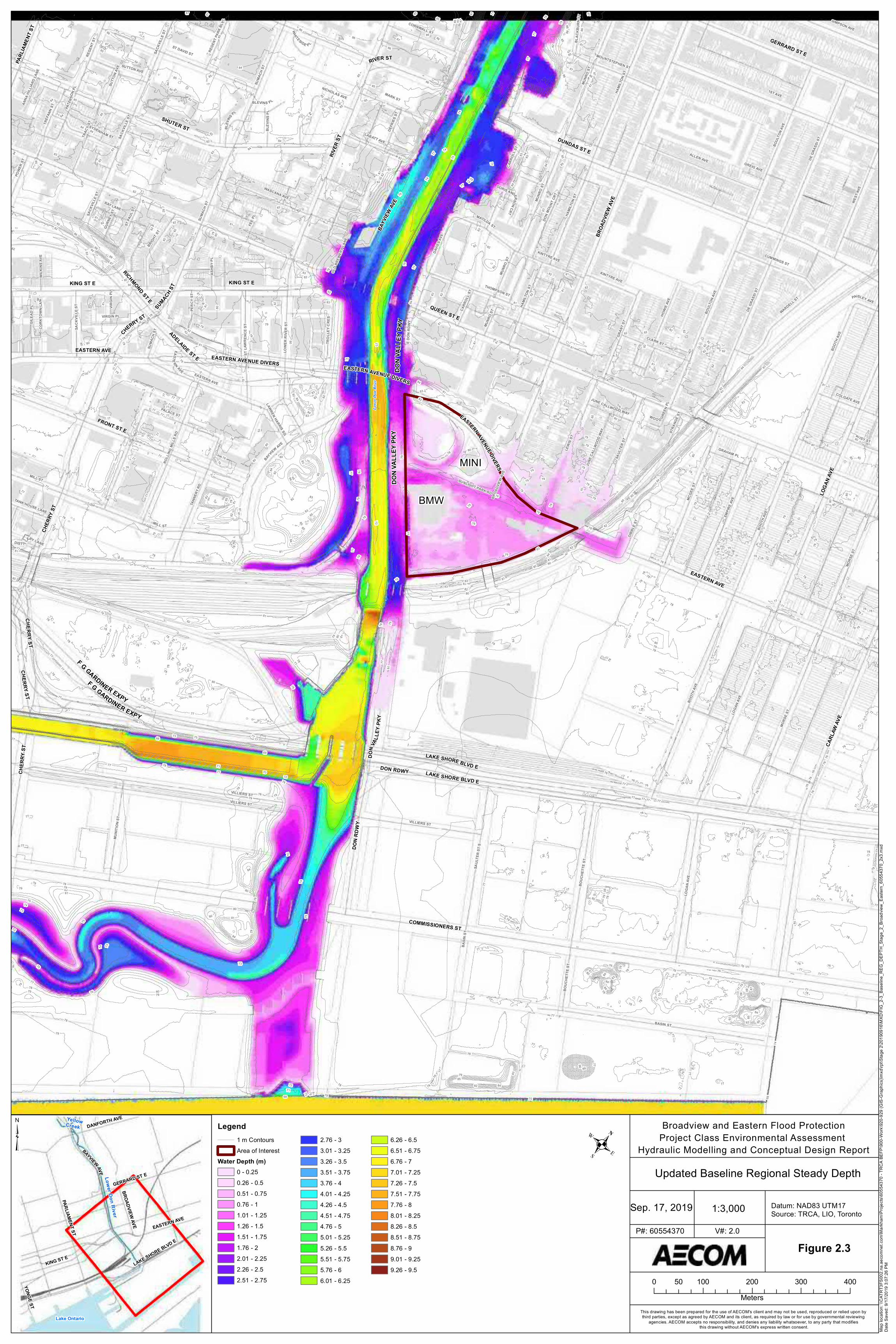
SACK
VILLE
ST
BRIGHT
ST
CLARK ST
PAISLEY AVE
KINTYRE AVE
THOMPSON ST
DORIS ANDERSONCRT
LABATT AVE
GREIG AVE
BOUL
TON A
VE
TANK HOUSE LANECA
RROL
L ST
JUNE
CALL
WOOD
WAY
GRAN
T ST
BASIN
ST
BASIN ST
REGE
NT ST
MOUNTSTEPHEN ST
MUNI
TION
ST
STLA
WR E
NCES
T
ASHB
Y PL
SYDENHAM ST
LAWREN HARRIS SQ
PATE
RSON
PL
BUSY ST
CUMMINGS ST
EASTERN AVE
HAMI
LTON
ST
GILE
AD P
L
MATILDA ST
SACK
VILLE
ST
MUNR
OST
HAMI
LTON
ST
TRAC
Y ST
SAUL
TER S
T
RAY LANE
BAYVIEW AVEGRAHAM PL
CARR
OLL S
T
BOOT
H AVE
VIRGIN PL
HAMI
LTON
ST
BLEVINS PLMARK ST
ALLEN AVE
WEST
AVE
MILL ST
BROA
DVIEW
AVE
EASTERN AVE
MORS
E ST
DON M
OUNT
CRT
MUNR
O ST
TREF
ANN ST
MORS
E STLOGA
N AVE
LOWE
R RI
VER
ST
ST PA
UL ST
EMPIR
E AVE
JUNE CALLWOOD WAY
OLD B
REWE
RY LA
NE
BOUL
TON A
VE
MCGE
E ST
LEWI
S ST
BOOT
H AVE
SUMA
CH ST
GURN
EY ST
DE G
RASS
I ST
ST DAVID ST
SUTTON AVE
WOO D GREE
NPL
DIST IL LERY LANE
VIRGI
N PL
SUTT
ON AV
E
STRA
NGE S
T
WILK
INS A
VE
BLAC
KBUR
NS T
BLEV
INS P
L
ANNA
HILLIA
RDLA
NE
1ST AVE
DAVIE
S AVE
PERC
Y ST
BLEV
INS
PL
DIBBL
E ST
PALACE ST
FEE P
L
MUNR
O ST
TROL
LEY C
RES
WARDELL ST
POWE
R ST
DEFR
IES ST
SUNLIGHT PARK RD
DE G
RASS
I ST
CORK
TOWN
LANE
SAUL
TER
ST S
MUNR
O ST
WHITESIDE PL
REGE
NT PA
RK BL
VD
MILL ST
KINTYRE AVE
E DON
RDW
Y
BOUC
HETT
E ST
SACK
VILLE
ST
HOWI
E AVE
CORNWALL ST
SIMPSON AVE
BOOT
H AVE
NICHOLAS AVE
VILLIERS ST
VILLIERS ST
VILLIERS ST
BOUC
HETT
E ST
LOGA
N AVE
COLGATE AVE
SUMA
CH ST
SACK
VILLE
ST
SUMA
CH ST
WASCANA AVETA
NNER
Y RD
ROLL
INGMI
LLS R
D
KING ST E
CARL
AW AV
E
QUEEN ST E
BROA
DVIEW
AVE
EASTERN AVE
RIVER
STEASTERN AVE
SHUTER ST
CHER
RYST
GERRARD ST E
SUMACH ST
KING ST E
BAYV
IEWAV
E
DUNDAS ST E
DON
RDW
Y
EASTERN AVENUE DIVERS
CHER
RY ST
CHERRYST
LOGA
N AVE
PARL
IAMEN
T ST
RIVER ST
EASTERN AVENUE DIVERS
LAKE SHORE BLVD E
FRONT ST E
LAKE SHORE BLVD E
CHERRY ST
DON RDWY
CHERRY ST
COMMISSIONERS ST
ADELAIDE ST E EASTERN AVENUE DIVERS
RICHMOND ST E
DON V
ALLEY
PKY
D ON
VALL
EYPK
YDO
N VA
LLEY
PKY
F G GARDINER EXPY
F G GARDINER EXPY
90
77
74
7271
68 76
7573
81
80
79
78
70
7672
7771
8077
86
79
7884
83
85
8286
85
87
79
84
83
84
78
77
85
80 78
8579
78
7978
77
75
888483
8582
8583
82
84
81
85 82 81
8483
7978
8177
8180
84
80
79 78
77
8483
8582
838280
818079
78
87
86
83 82
8482
83 82
818079
79
78
77
8079
78
797877
8079
78
77
78
76
78
76
77
75
7574
73
878685
858484
83
83
82
84
82
8483
8381
83
82
82
81
81
80
8079
7978
78
77
7978
7978
79
77
77
76
7877
7877
8786
87
86
85
84
85
84
85
84
84
83
84 83
8483
83
82
83
82
8281
8180
81 80
81
80
81
80
7978
79
78
79
78
7978
79
78
79
78
78
77
78
77
78
7778
77
78
77
7877
78
77
78
77
7877
78
77
7877
77
76
77
76
77
76
77
76
77
76
77
76
7776
77
76
77
76
77
76
77
76
75
74
74 73
73
72
70 69
84
82
75
74
73
69
68
76
79
84
83
82
87
86
80
84
83
82
81
82
85
85
83
82
84 83
81
79
81
76
89
87
82
84
82
84
84
82
82
82
81
82
81
80
78
79
80
80
79
80
79
78
78
77
78
78
77
79
79
79
78
78
76
77
76
78
78
78
78
78
77
75
77
77
89
87
87
87
87
8787
85
85
85
86
86
86
86
86
86
85
85
84
85
85
85
85
85
85
85
8585
8585
85
85
84
83
83
83
84
84
8484
84
83
84
84
82
83
83
83
83
83
83
83
82
81
81
81
81
82
82
82
82
82
82
82
82
82
8282
82
82
82
82
82
82
82
82
81
81
81
81
81
80
80
81
81
81
81
81
81
80
8080
80
79
79
79
79
79
80
80
80
80
80
80
80
80
80
80
79
79
80
78
78
78
7878
79
79
79
79
79
79
79
79
79
79
79
79
79
79
79
79
79
78
79
79
79
79
79
79
79
79
78
78
78
78
78
78
78
78
78
77
77
77
77
77
78
78
78
78
78
78
78
78
77
78
78
78
78
78
78
78
77
78
78
78
78
77
78
78
7877
78
7878
78
77
77
77
7777
77
77
7777
77
77
77
77
77
76
76
76
76
76
76
7676
77
77
77
77
77
77
77
77
77
77
77
77
77
77
77
77
77
77
77
77
77
77
76
77
77
76
76
76
76
76
75
75
75
74
74
74
7372
86
85
85
84
84
83
82
82
82
82
81
80
80
8080
79
79
79
79
79
7979
79
79
7979
78
78
78
78
78
78
78
7878
78
78
78
78
77
77
77
77
77
77
77
77
77
77
77
77
77
77
77
77
77
77
77
77
77
77
77
77
77
76
BMW
MINI
Lowe
r Don
Rive
r
0 100 200 300 40050Meters
Sep. 17, 2019 1:3,000
Figure 2.3
Broadview and Eastern Flood ProtectionProject Class Environmental Assessment
Hydraulic Modelling and Conceptual Design Report
Updated Baseline Regional Steady Depth
P#: 60554370 V#: 2.0
Datum: NAD83 UTM17Source: TRCA, LIO, Toronto
This drawing has been prepared for the use of AECOM's client and may not be used, reproduced or relied upon by third parties, except as agreed by AECOM and its client, as required by law or for use by governmental reviewing
agencies. AECOM accepts no responsibility, and denies any liability whatsoever, to any party that modifies this drawing without AECOM's express written consent. Ma
p loc
ation
: \\CA
TRT3
FS00
2.na.a
ecom
net.c
om\M
arkha
m\Pr
ojects
\6055
4370
- TRC
A BEF
P\90
0-Work
\920-9
29 (G
IS-Gr
aphic
s)\mx
d\rpt\
Stage
2\20
1909
16\M
XD\FI
G_2-3
_Bas
eline
_REG
_DEP
TH_S
tage_
2_Br
oadv
iew_E
aster
n_60
5543
70_2
x3.m
xdDa
te Sa
ved:
9/17/2
019 3
:07:26
PM
Lake Ontario
YellowCreek
Lower Don RiverBROADVIEW AVE
GERRARD ST E
EASTERN AVE
DANFORTH AVE
KING ST E
PARLIAMENT ST
YONGEST
BAYVIEW AVE
LAKE SHORE BLVD E
³ Legend1 m ContoursArea of Interest
Water Depth (m)0 - 0.250.26 - 0.50.51 - 0.750.76 - 11.01 - 1.251.26 - 1.51.51 - 1.751.76 - 22.01 - 2.252.26 - 2.52.51 - 2.75
2.76 - 33.01 - 3.253.26 - 3.53.51 - 3.753.76 - 44.01 - 4.254.26 - 4.54.51 - 4.754.76 - 55.01 - 5.255.26 - 5.55.51 - 5.755.76 - 66.01 - 6.25
6.26 - 6.56.51 - 6.756.76 - 77.01 - 7.257.26 - 7.57.51 - 7.757.76 - 88.01 - 8.258.26 - 8.58.51 - 8.758.76 - 99.01 - 9.259.26 - 9.5
.
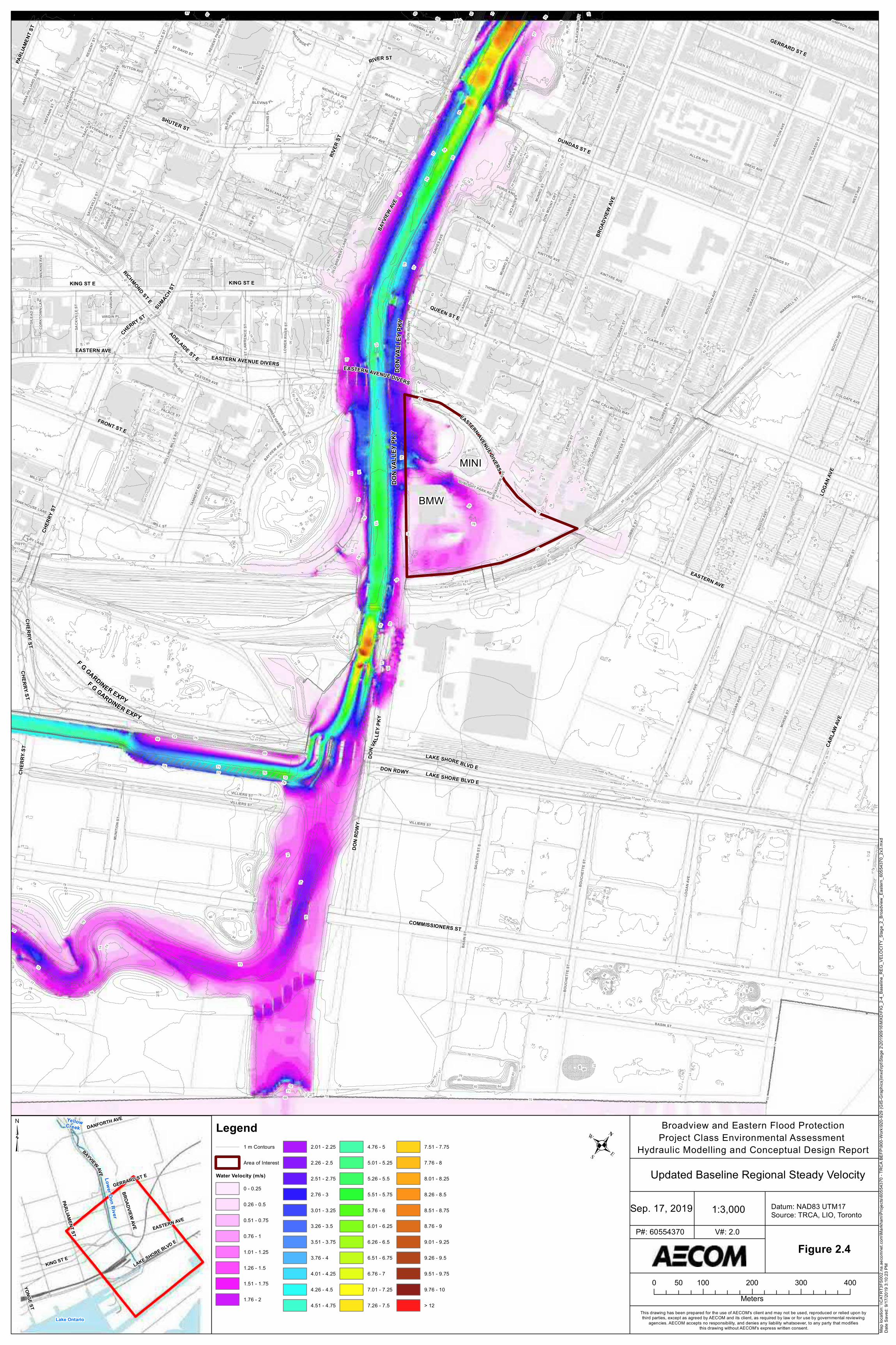
SACK
VILLE
ST
BRIGHT
ST
CLARK ST
PAISLEY AVE
KINTYRE AVE
THOMPSON ST
DORIS ANDERSONCRT
LABATT AVE
GREIG AVE
BOUL
TON A
VE
TANK HOUSE LANECA
RROL
L ST
JUNE
CALL
WOOD
WAY
GRAN
T ST
BASIN
ST
BASIN ST
REGE
NT ST
MOUNTSTEPHEN ST
MUNI
TION
ST
STLA
WR E
NCES
T
ASHB
Y PL
SYDENHAM ST
LAWREN HARRIS SQ
PATE
RSON
PL
BUSY ST
CUMMINGS ST
EASTERN AVE
HAMI
LTON
ST
GILE
AD P
L
MATILDA ST
SACK
VILLE
ST
MUNR
OST
HAMI
LTON
ST
TRAC
Y ST
SAUL
TER S
T
RAY LANE
BAYVIEW AVEGRAHAM PL
CARR
OLL S
T
BOOT
H AVE
VIRGIN PL
HAMI
LTON
ST
BLEVINS PLMARK ST
ALLEN AVE
WEST
AVE
MILL ST
BROA
DVIEW
AVE
EASTERN AVE
MORS
E ST
DON M
OUNT
CRT
MUNR
O ST
TREF
ANN ST
MORS
E STLOGA
N AVE
LOWE
R RI
VER
ST
ST PA
UL ST
EMPIR
E AVE
JUNE CALLWOOD WAY
OLD B
REWE
RY LA
NE
BOUL
TON A
VE
MCGE
E ST
LEWI
S ST
BOOT
H AVE
SUMA
CH ST
GURN
EY ST
DE G
RASS
I ST
ST DAVID ST
SUTTON AVE
WOO D GREE
NPL
DIST IL LERY LANE
VIRGI
N PL
SUTT
ON AV
E
STRA
NGE S
T
WILK
INS A
VE
BLAC
KBUR
NS T
BLEV
INS P
L
ANNA
HILLIA
RDLA
NE
1ST AVE
DAVIE
S AVE
PERC
Y ST
BLEV
INS
PL
DIBBL
E ST
PALACE ST
FEE P
L
MUNR
O ST
TROL
LEY C
RES
WARDELL ST
POWE
R ST
DEFR
IES ST
SUNLIGHT PARK RD
DE G
RASS
I ST
CORK
TOWN
LANE
SAUL
TER
ST S
MUNR
O ST
WHITESIDE PL
REGE
NT PA
RK BL
VD
MILL ST
KINTYRE AVE
E DON
RDW
Y
BOUC
HETT
E ST
SACK
VILLE
ST
HOWI
E AVE
CORNWALL ST
SIMPSON AVE
BOOT
H AVE
NICHOLAS AVE
VILLIERS ST
VILLIERS ST
VILLIERS ST
BOUC
HETT
E ST
LOGA
N AVE
COLGATE AVE
SUMA
CH ST
SACK
VILLE
ST
SUMA
CH ST
WASCANA AVETA
NNER
Y RD
ROLL
INGMI
LLS R
D
KING ST E
CARL
AW AV
E
QUEEN ST E
BROA
DVIEW
AVE
EASTERN AVE
RIVER
STEASTERN AVE
SHUTER ST
CHER
RYST
GERRARD ST E
SUMACH ST
KING ST E
BAYV
IEWAV
E
DUNDAS ST E
DON
RDW
Y
EASTERN AVENUE DIVERS
CHER
RY ST
CHERRYST
LOGA
N AVE
PARL
IAMEN
T ST
RIVER ST
EASTERN AVENUE DIVERS
LAKE SHORE BLVD E
FRONT ST E
LAKE SHORE BLVD E
CHERRY ST
DON RDWY
CHERRY ST
COMMISSIONERS ST
ADELAIDE ST E EASTERN AVENUE DIVERS
RICHMOND ST E
DON V
ALLEY
PKY
D ON
VALL
EYPK
YDO
N VA
LLEY
PKY
F G GARDINER EXPY
F G GARDINER EXPY
90
77
74
7271
68 76
7573
81
80
79
78
70
7672
7771
8077
86
79
7884
83
85
8286
85
87
79
84
83
84
78
77
85
80 78
8579
78
7978
77
75
888483
8582
8583
82
84
81
85 82 81
8483
7978
8177
8180
84
80
79 78
77
8483
8582
838280
818079
78
87
86
83 82
8482
83 82
818079
79
78
77
8079
78
797877
8079
78
77
78
76
78
76
77
75
7574
73
878685
858484
83
83
82
84
82
8483
8381
83
82
82
81
81
80
8079
7978
78
77
7978
7978
79
77
77
76
7877
7877
8786
87
86
85
84
85
84
85
84
84
83
84 83
8483
83
82
83
82
8281
8180
81 80
81
80
81
80
7978
79
78
79
78
7978
79
78
79
78
78
77
78
77
78
7778
77
78
77
7877
78
77
78
77
7877
78
77
7877
77
76
77
76
77
76
77
76
77
76
77
76
7776
77
76
77
76
77
76
77
76
75
74
74 73
73
72
70 69
84
82
75
74
73
69
68
76
79
84
83
82
87
86
80
84
83
82
81
82
85
85
83
82
84 83
81
79
81
76
89
87
82
84
82
84
84
82
82
82
81
82
81
80
78
79
80
80
79
80
79
78
78
77
78
78
77
79
79
79
78
78
76
77
76
78
78
78
78
78
77
75
77
77
89
87
87
87
87
8787
85
85
85
86
86
86
86
86
86
85
85
84
85
85
85
85
85
85
85
8585
8585
85
85
84
83
83
83
84
84
8484
84
83
84
84
82
83
83
83
83
83
83
83
82
81
81
81
81
82
82
82
82
82
82
82
82
82
8282
82
82
82
82
82
82
82
82
81
81
81
81
81
80
80
81
81
81
81
81
81
80
8080
80
79
79
79
79
79
80
80
80
80
80
80
80
80
80
80
79
79
80
78
78
78
7878
79
79
79
79
79
79
79
79
79
79
79
79
79
79
79
79
79
78
79
79
79
79
79
79
79
79
78
78
78
78
78
78
78
78
78
77
77
77
77
77
78
78
78
78
78
78
78
78
77
78
78
78
78
78
78
78
77
78
78
78
78
77
78
78
7877
78
7878
78
77
77
77
7777
77
77
7777
77
77
77
77
77
76
76
76
76
76
76
7676
77
77
77
77
77
77
77
77
77
77
77
77
77
77
77
77
77
77
77
77
77
77
76
77
77
76
76
76
76
76
75
75
75
74
74
74
7372
86
85
85
84
84
83
82
82
82
82
81
80
80
8080
79
79
79
79
79
7979
79
79
7979
78
78
78
78
78
78
78
7878
78
78
78
78
77
77
77
77
77
77
77
77
77
77
77
77
77
77
77
77
77
77
77
77
77
77
77
77
77
76
BMW
MINI
0 100 200 300 40050Meters
Sep. 17, 2019 1:3,000
Figure 2.4
Updated Baseline Regional Steady Velocity
P#: 60554370 V#: 2.0
Datum: NAD83 UTM17Source: TRCA, LIO, Toronto
This drawing has been prepared for the use of AECOM's client and may not be used, reproduced or relied upon by third parties, except as agreed by AECOM and its client, as required by law or for use by governmental reviewing
agencies. AECOM accepts no responsibility, and denies any liability whatsoever, to any party that modifies this drawing without AECOM's express written consent. Ma
p loc
ation
: \\CA
TRT3
FS00
2.na.a
ecom
net.c
om\M
arkha
m\Pr
ojects
\6055
4370
- TRC
A BEF
P\90
0-Work
\920-9
29 (G
IS-Gr
aphic
s)\mx
d\rpt\
Stage
2\20
1909
16\M
XD\FI
G_2-4
_Bas
eline
_REG
_VEL
OCITY
_Stag
e_2_
Broa
dview
_Eas
tern_
6055
4370
_2x3
.mxd
Date
Save
d: 9/1
7/201
9 3:10
:23 PM
Lake Ontario
YellowCreek
Lower Don RiverBROADVIEW AVE
GERRARD ST E
EASTERN AVE
DANFORTH AVE
KING ST E
PARLIAMENT ST
YONGEST
BAYVIEW AVE
LAKE SHORE BLVD E
³ .Legend1 m Contours
Area of Interest
Water Velocity (m/s)
0 - 0.25
0.26 - 0.5
0.51 - 0.75
0.76 - 1
1.01 - 1.25
1.26 - 1.5
1.51 - 1.75
1.76 - 2
2.01 - 2.25
2.26 - 2.5
2.51 - 2.75
2.76 - 3
3.01 - 3.25
3.26 - 3.5
3.51 - 3.75
3.76 - 4
4.01 - 4.25
4.26 - 4.5
4.51 - 4.75
4.76 - 5
5.01 - 5.25
5.26 - 5.5
5.51 - 5.75
5.76 - 6
6.01 - 6.25
6.26 - 6.5
6.51 - 6.75
6.76 - 7
7.01 - 7.25
7.26 - 7.5
7.51 - 7.75
7.76 - 8
8.01 - 8.25
8.26 - 8.5
8.51 - 8.75
8.76 - 9
9.01 - 9.25
9.26 - 9.5
9.51 - 9.75
9.76 - 10
> 12
Broadview and Eastern Flood ProtectionProject Class Environmental Assessment
Hydraulic Modelling and Conceptual Design Report