broadrunestates bosreport 070920
TRANSCRIPT

1
Department of Community Development Staff Report
PROPERTY OWNERS: Lakeside Homes, LLC, Homeowners Association of Brookside and
James M. & Kathleen K. Rohr APPLICANT: Lakeside Homes, LLC LOCATION: 4525, 4569, 4589, 4627 and 4629 Broad Run Church Road, Warrenton DISTRICT: Scott District PINS: 7906-90-4594-000, 7906-90-0728-000, 7906-91-7338-000, 7906-91-
6062-000, 7906-81-7310-000, 7916-00-5721-000, 7916-00-8844-000, 7916-10-0714-000, 7916-10-1643-000, 7916-10-2576-000, 7916-10-1218-000, 7916-00-9374-000, 7916-00-8482-000, 7916-00-7580-000, 7916-00-7233-000, 7916-00-7919-000 and 7916-00-7838-000
ACREAGE: 112.39 Acres ZONING: Residential: 1 Unit per Acre (R-1) LAND USE: New Baltimore Service District – Low Density Residential (LDR) up to
3 Dwelling Units per Acre, Neighborhood Center and FEMA Floodplain
MEETING DATE: July 9, 2020 REQUEST: REZN-19-011186: An application to rezone approximately 112.39
acres from Residential: 1 Unit per Acre (R-1) to Residential: 4 Units per Acre (R-4) with proffers.
OUTSTANDING ISSUES: None identified by staff. RECOMMENDATION: The Planning Commission voted 4 to 1 to recommend approval of
Rezoning REZN-19-011186. They believe that the application is consistent with the land use designation of the Comprehensive Plan and able to meet the applicable provisions of the Zoning Ordinance.
An Ordinance to Approve REZN-19-011186 as well as a Resolution to Deny REZN-19-011186 have been prepared for the Board’s consideration.

2
Topic Description: Lakeside Homes, LLC, is seeking to rezone approximately 112.39 acres from Residential: 1 Unit per Acre (R-1) to Residential: 4 Units per Acre (R-4) with proffers. According to the Statement of Justification, the Applicant’s goal with Broad Run Estates is to ensure a quality community through the rezoning of the property to R-4 and to use the cluster development provisions set forth in the Zoning Ordinance to create a mixture of lot sizes and types. The proposal is to use the approximate by-right densities from three previously approved projects (Broad Run Estates, Riley’s Estates and Ringwood Farm) and one additional unplanned property (Rohr property), and incorporate those units into one cohesive master planned development with additional density. This request would allow for the development of a maximum of 166 single-family detached units at Broad Run Estates. When accounting for the project’s net area (total area less the floodplain area and less half of the area of water bodies on site) the proposed development equates to 1.72 dwelling units per acre. The Applicant believes this approach optimally utilizes the land and allows for it to be developed in a coordinated fashion which is consistent with the Comprehensive Plan’s vision for New Baltimore.
Regional Aerial Map

3
The Applicant states that the Broad Run Estates concept is formed directly from the principles of the New Baltimore Service District Plan as it employs a neo-traditional, pedestrian friendly design that actively engages its frontage along Broad Run Church Road. It also preserves the environmentally sensitive features located at the rear of the property, along South Run. The development proposal includes a variety of lot sizes and types, to include front, side and rear loaded products. Additionally, Design Guidelines which require a consistent quality of construction throughout the community will be incorporated into the Homeowners Association (HOA) documents. A draft version of the Design Guidelines has been attached for reference. They regulate building materials, lighting and architecture of the houses. Architectural variation of the homes and variation of the building setbacks are proposed to be required throughout the development and within each block by the Design Guidelines.
Site Aerial Map
A key component of the application is the ultimate preservation of Ringwood Farm (PIN 7914-48-5419-000) through a perpetual conservation easement. The 73.28-acre Ringwood Farm property is located on the southeast side of Rogues Road (SR 602) just outside of the New Baltimore Service District (NBSD) and is zoned R-1. On October 8, 2014, a Preliminary Plat (PPLT14-CR-001) showing 47 single-family detached lots using public water provided by the Fauquier County Water and Sanitation Authority (FCWSA) and individual private drainfields was approved by the Board of
Broad Run Estates
Rohr Property
Riley’s Estates
Broad Run Estates

4
Supervisors. A Construction Plan (CONP-14-001770) which includes 45 lots was approved on July 10, 2015. An amendment to the Construction Plan (CONP-19-011006) which includes 42 lots is currently being reviewed by the County. The proposed conservation easement would prohibit subdivision of the property and limit its development to a maximum of one house, one tenant house and typical accessory structures. This would eliminate the extension of the public water to Ringwood Farm outside of the NBSD. Additionally, it would remove the creation of septic fields associated with the future residential development. It also would significantly reduce the removal of mature tree canopy coverage and wetland impacts needed to construct the subdivision’s infrastructure. Planning Commission Action on December 19, 2019: On December 19, 2019, the Planning Commission discussed this item at its work session and conducted a public hearing. There were six speakers at the public hearing – the Applicant’s representative, Mr. Chuck Floyd, and one other person spoke in support of the application and four spoke in opposition. Mr. Floyd stated that they worked with staff to get the best plan for the County and develop the property in accord with the Comprehensive Plan. A resident of the Cedar Run District spoke in support of moving the density from Ringwood Farm because of the poor drainage there. Four speakers, from the Scott District, expressed opposition to the application. They generally shared the same concerns related to the proposed density being too high, the ability of Broad Run Church Road to accommodate increased traffic, and impacts to the infrastructure. After the public hearing and a brief discussion, the Planning Commission voted 4 to 1 to recommend approval of the Rezoning application. Those who supported the motion generally felt the proposal was better and more consistent with the Comprehensive Plan than the by-right development. It was also stated that the proffers associated with a rezoning would help to address capital impacts, whereas the by-right development would not have any financial contribution. The Commissioner who did not support the motion agreed that the rezoning concept was better than the by-right plan, but that the proposal was too dense/had too many units. Following the Planning Commission’s recommendation, the Applicant requested that the application be placed on hold. The delay was to allow them to work with County staff and VDOT to address the required improvements to Broad Run Church Road (Route 600) and understand the potential costs to the development. On March 3, 2020, the Applicant submitted an exhibit for the Route 600 improvements which addresses the County’s requirement for curb and gutter, see attached. The exhibit shows improvements to the southern half of Broad Run Church Road along the project’s frontage, which are based on the section envisioned in the Comprehensive Plan and meet the requirements of the Subdivision Ordinance. These improvements include an eight foot wide striped median, a 12 foot wide travel lane, a nine foot wide landscape strip, and a 10 foot wide multi-use path. These proposed improvements will be further evaluated during the Preliminary Plat and Construction Plan phases of the project. Planning Commission Action on September 19, 2019: On September 19, 2019, the Planning Commission discussed this item at its work session and conducted a public hearing. There were 24 speakers at the public hearing; the Applicant’s representative, Mr. Chuck Floyd and four others spoke in support of the application; 18 spoke in

5
opposition and one person did not clearly indicate their position. Three of those in support of the application generally supported the application based on the concept of a conservation easement being placed on Ringwood Farm with only limited future development occurring there. Another speaker who supports the application preferred the proposed concept plan over the previously approved plan. Those in opposition generally expressed and shared the same concerns. Their concerns were related to traffic impacts, taxes, water/sewer capacity, and school capacity. It was generally expressed that the existing R-1 zoning was more appropriate and in keeping with the surrounding development patterns. Two of the speakers also mentioned that there are old subdivisions in New Baltimore which are experiencing failing drainfields, and that sewer capacity/improvements should be allocated to those properties before allowing new developments to connect. The Planning Commission voted unanimously to postpone action on the application for 90 days, with the public hearing left open. The Planning Commissioners also indicated their desire to conduct an official site visit. On November 13, 2019, members of the Planning Commission toured the Broad Run Estates property and visited nearby projects which have homes constructed by the Applicant. Project History: As mentioned above, the current proposal for Broad Run Estates is to incorporate the by-right densities from Broad Run Estates, Riley’s Estates and Ringwood Farm, which all have previous approvals. The proposal also incorporates the Rohr property, which has been unplanned to date. These four projects/properties have a total maximum by-right density of 148 units. A total of 100 units have been approved or proposed on a Construction Plan and an additional four units are estimated to be achievable on the Rohr property. The following is a summary of each of these projects/properties and their approvals.
Broad Run Estates PINs: 7906-90-4594-000, 7906-90-0728-000, 7906-91-6062-
000 and 7906-81-7310-000 Zoned: R-1 Total Area: 95.79 acres Net Area*: 80.39 acres Maximum By-Right Density: 72 lots (0.9 du x 80.39 ac) Construction Plan Density: 50 lots (CONP-17-007603, Approved 7/13/18) Riley’s Estates PINs: 7916-007919-000, 7916-00-7838-000, 7916-00-7233-
000, 7916-10-2576-000, 7916-10-1643-000, 7916-00-0714-000, 7916-00-8844-000, 7916-00-7580-000, 7916-00-8482-000, 7916-00-9374-000 and 7916-10-1218-000
Zoned: R-1 Total Area: 9.83 acres Net Area*: 9.83 acres Maximum Density: 8 lots (0.9 du x 9.83 ac) Construction Plan Density: 8 lots (CONP-17-006692, Approved 10/24/17)
6
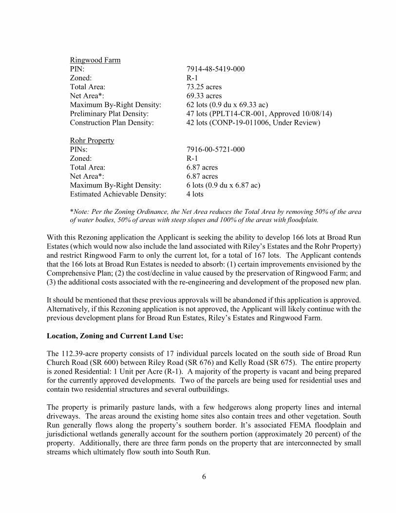
Ringwood Farm PIN: 7914-48-5419-000 Zoned: R-1 Total Area: 73.25 acres Net Area*: 69.33 acres Maximum By-Right Density: 62 lots (0.9 du x 69.33 ac) Preliminary Plat Density: 47 lots (PPLT14-CR-001, Approved 10/08/14) Construction Plan Density: 42 lots (CONP-19-011006, Under Review) Rohr Property PINs: 7916-00-5721-000 Zoned: R-1 Total Area: 6.87 acres Net Area*: 6.87 acres Maximum By-Right Density: 6 lots (0.9 du x 6.87 ac) Estimated Achievable Density: 4 lots *Note: Per the Zoning Ordinance, the Net Area reduces the Total Area by removing 50% of the area of water bodies, 50% of areas with steep slopes and 100% of the areas with floodplain.
With this Rezoning application the Applicant is seeking the ability to develop 166 lots at Broad Run Estates (which would now also include the land associated with Riley’s Estates and the Rohr Property) and restrict Ringwood Farm to only the current lot, for a total of 167 lots. The Applicant contends that the 166 lots at Broad Run Estates is needed to absorb: (1) certain improvements envisioned by the Comprehensive Plan; (2) the cost/decline in value caused by the preservation of Ringwood Farm; and (3) the additional costs associated with the re-engineering and development of the proposed new plan. It should be mentioned that these previous approvals will be abandoned if this application is approved. Alternatively, if this Rezoning application is not approved, the Applicant will likely continue with the previous development plans for Broad Run Estates, Riley’s Estates and Ringwood Farm. Location, Zoning and Current Land Use: The 112.39-acre property consists of 17 individual parcels located on the south side of Broad Run Church Road (SR 600) between Riley Road (SR 676) and Kelly Road (SR 675). The entire property is zoned Residential: 1 Unit per Acre (R-1). A majority of the property is vacant and being prepared for the currently approved developments. Two of the parcels are being used for residential uses and contain two residential structures and several outbuildings. The property is primarily pasture lands, with a few hedgerows along property lines and internal driveways. The areas around the existing home sites also contain trees and other vegetation. South Run generally flows along the property’s southern border. It’s associated FEMA floodplain and jurisdictional wetlands generally account for the southern portion (approximately 20 percent) of the property. Additionally, there are three farm ponds on the property that are interconnected by small streams which ultimately flow south into South Run.

7
As mentioned previously, a portion of the property has an approved Construction Plan for Broad Run Estates and can be developed into 50 residential lots. Additionally, the Riley’s Estates portion of the property has been subdivided into eight residential lots and initial construction (road base and utility installation) of Thoroughbred Road has been completed.
Location/Zoning Map
Surrounding Zoning and Current Land Use: The areas immediately surrounding the subject property are zoned R-1 and Commercial – Neighborhood (C-1). Further out the properties are zoned Rural Agricultural (RA); R-1; Residential: 4 Units per Acre (R-4); C-1 and Commercial – Highway (C-2). The R-1 properties are primarily developed with single-family detached residential units. Lots in this area are generally one acre in size or larger. C. Hunter Ritchie Elementary School, at the northeastern quadrant of the intersection of Broad Run Church Road and Riley Road, is also located in the R-1 zoned area. The C-1 zoned parcels contain single-family detached residences, the New Baltimore Volunteer Fire and Rescue Company, or are undeveloped. A historic resources conservation easement has been placed on the R-4 zoned parcels, which were formerly planned to be a subdivision (Bishop’s Run). As such, this area remains undeveloped. The C-2 zoned properties are used as single-family residences along Broad

8
Run Church Road and commercial uses along Lee Highway. The C-2 parcels between these two roads are generally undeveloped but planned for commercial development. Comprehensive Plan/Land Use: The property is within the New Baltimore Service District (NBSD). The vision for New Baltimore is “The future development in New Baltimore will bring with it a defined sense of place. There will be a place and opportunity for a Fourth of July parade, farmer’s market, meeting destination, landmark, park/gathering place and overall pride in community.” The NBSD Plan outlines development relationships, including residential densities for future neighborhoods, business expansion, location of proposed schools and other basic public facilities. It also illustrates the needed road network improvements to support the anticipated service district growth. The purpose of the NBSD Land Use Plan is to provide a template for managed growth that is appropriate to the community and can be supported by existing and planned public utilities. One of the major features is that higher density residential and commercial uses are restricted primarily to only those areas north of South Run. It should be noted that the entire property is located north of South Run. The sections below summarize the relevant portions of the NBSD Plan. Additionally, selected figures from the Plan have been attached for reference. Land Use A majority of the property has a land use designation of Low Density Residential (LDR) up to 3 Dwelling Units per Acre. The Service District Plan states that the design of all new developments should respect the overall character of New Baltimore as well as its individual neighborhoods. The Plan promotes small residential clusters with a neighborhood identity and a sense of place, while enabling connectivity among neighborhoods. It also encourages the use of clustering for residential development to create open spaces, preserve natural features, and provide natural separations between otherwise incompatible uses. Additionally, subdivisions are encouraged to locate parkland adjacent to one another to create an overall larger park. The portion of the property at the southwestern quadrant of the intersection of Broad Run Church Road and Riley Road (currently Riley’s Estates) has a land use designation of Neighborhood Center. These areas are planned to provide a limited range of commercial retail, service and office uses, as well as civic and residential uses. The overall intent is small scale neighborhood-type uses, typically associated with the C-1 commercial district. Commercial uses are to be built at a scale that serves the local neighborhood and follow mixed-use urban planning design principles. In addition, dwellings above retail and office uses are encouraged. While limited residential is envisioned in the Neighborhood Center, the NBSD Plan specifically states that townhouses, single-family attached dwellings, and multi-family dwellings are not planned for the southwest quadrant of the Route 676/600 intersection, where the project is located. The plan does encourage residential uses above retail, as permitted in the Commercial-1 zoning district, in these areas. The southern portion (along South Run) of the property is designated as FEMA floodplain. The Service District Plan states that the environmental features that are critical to the character and quality of life of the community should be preserved. They are also envisioned to provide for both passive and active recreational opportunities. The Plan states that future development should ensure the protection and

9
conservation of surface and groundwater resources. The sound management of wetlands, floodplains, streams and water bodies is also encouraged.
Land Use Map
Transportation The Transportation section of the NBSD Plan identifies new roads within the project area and improvements to the roads surrounding the project. It also establishes a roadway classification or “Thoroughfare Type” for the existing and future roads within the Service District. Each of the thoroughfare types has an associated cross section which shows its intended future design. The Plan states that the necessary rights-of-way for any new road alignment or widening of existing roads is expected to be dedicated through rezoning, subdivision and site plan applications. Additionally, new development is expected to construct and/or provide financial contributions toward the phased construction of improved roads to which it needs access. The Plan identifies Broad Run Church Road (SR 600) as the only Major Avenue within New Baltimore. It acts as a key transitional space that separates the mixed-use and commercial area of the Triangle and the residential areas to its south. Broad Run Church Road is to serve as both a local transit route and primary pedestrian and bicycle route. The envisioned cross section has a total right-

10
of-way of 81 to 83 feet, which contains a 16 foot wide median with single travel lanes on each side. Parking is planned on the commercial side, with curb and gutter and landscape planting strips on both sides. The commercial side of the road is to have a six foot wide sidewalk, and the residential side is to have a 10 foot wide multi-use trail. The plan also proposes a new roundabout to be designed and installed at the intersection of Broad Run Church Road and Riley Road (SR 676). Riley Road is identified as a Through Street. Through Streets are intended to carry traffic, provide access to abutting properties in rural areas, and provide circulation around the edges and developed areas of New Baltimore. It is envisioned to have two travel lanes with a shoulder and ditch section within a 55 foot wide right-of-way. A 10 foot wide multi-use trail is also to be located on one side of the street. A new Minor Avenue which generally extends Hummingbird Lane to Riley Road is proposed east and west through the project area. Minor Avenues are to serve as local transit routes and primary pedestrian and bicycle routes, with their primary function being access to land. They are to be designed to be a low-to-medium speed (25 to 35 mph) road that is walkable. Their envisioned cross section includes two travel lanes with an optional parking lane on one side of the street. A six foot wide landscape strip and 10 foot wide multi-use trail are also to be included on one side of the street. New local roads within residential subdivisions are to be designed on a generally rectangular grid network. They are planned to have two travel lanes with planting strips (six feet wide minimum) and sidewalks on both sides. In addition to the local roads needed to serve the development two new local roads within the project area are specifically envisioned. The first is the extension of Culver Drive south of Broad Run Church Road to connect to the new Minor Avenue. The second is to generally align with/allow for the extension of Commerce Court to also connect to the new Minor Avenue. Ringwood Farm It should also be mentioned that the Ringwood Farm property, which the Applicant has proffered to put into a conservation easement should this application be approved, is within the County’s rural lands. Chapter 8 of the Comprehensive Plan addresses land use in the rural areas of the County. It contains policies and plans to protect and preserve farmland, historic sites and open space. The Rural Land Use Plan is focused on preserving the physical beauty, historical heritage and environmental quality of the County, while growing its rural and agricultural economy to better serve its people and protect its heritage. The Rural Land Use Plan also states that conservation easements are a relatively flexible and effective tool for the principal purpose of protecting a property’s conservation and preservation values. Proposed Rezoning Analysis: This application is seeking to rezone approximately 112.39 acres from Residential: 1 Unit per Acre (R-1) to Residential: 4 Units per Acre (R-4) with proffers. This request, if approved, would allow for the development of 166 single-family detached units using the R-4 cluster development standards of the Zoning Ordinance at Broad Run Estates. Section 13-210 of the Zoning Ordinance gives additional guidance when reviewing and considering approval of Rezoning Applications, it states:

11
“Proposed amendments shall be considered with reasonable consideration of the existing use and character of the area, the suitability of the property for various uses, the trends of growth or change, the current and future requirements of the County as to land for various purposes as determined by population and economic studies and other studies, the transportation requirements of the community and the County and the requirements for schools, parks, playgrounds, recreation areas and other public services; for the conservation of natural resources and preservation of floodplains; and for the conservation of properties and their values and the encouragement of the most appropriate use of land throughout the County. These considerations shall include, but not be limited to, Comprehensive Plans or parts thereof, capital improvements programs, relation of development to roads or road construction programs, proximity of the development to utilities and public facilities, the existence of an Agricultural and Forestal District created pursuant to Chapter 36 of the Code of Virginia, and any applicable standards contained in Article 5.”
The Comprehensive Plan, within the Chapter 6 – Service Districts: Introduction, also offers further guidance to be considered with rezoning applications. It suggests that rezonings should occur when the applicant can demonstrate how the proposed zoning meets the intent of the Plan more effectively than the by-right zoning. The Comprehensive Plan also states that residential applications are expected to be presented at the low end of each density range for the specified service district location. It goes on to state that applications above the low end density range should justify those increases with the:
1. Provision of affordable housing (low/moderate income housing); and/or
2. Elimination of lot subdivision potential through easements (Purchase of Development Rights) on: (a) Rural Agricultural (RA) and Rural Conservation (RC) zoned properties generally located within the service district’s magisterial district; (b) property designated as parkland or marked as a hard open space edge along the service district boundary within the service district plan; or (c) a critical future transportation corridor designated by the Board of Supervisors needing protection from further development; and/or
3. Implementation of unique town-scaled designs consistent with the adopted service district plan; and/or
4. Other combinations other than cash/material contributions to the needs of the County. The Board of Supervisors should consider these matters as they relate to the Broad Run Estates application. Particular attention should be paid to the existing use and character of the area; the character for the area as envisioned in the New Baltimore Service District Plan; and the requirements for schools, parks and recreation areas, as well as other public services. The Board should also evaluate if the proposed zoning meets the intent of the Plan more effectively than the by-right zoning, and further if the applicant has justified an increase in density above the low end density range envisioned in the Comprehensive Plan.

12
Proposed Zoning Map
Capital Impact Model The application was analyzed in a capital impact model developed for Fauquier County by TischlerBise. The generated reports detail the estimated capital facility impact of the development proposal, and are for informational purposes only. The reports should not be considered a negotiation, a request, a suggestion or demand for proffers on the part of Fauquier County. The model estimates impacts that are directly attributable to the proposed new development while also taking into account existing capacities within constructed public facilities. The model evaluates capital impacts for the following categories of public capital improvements: (1) Public Schools; (2) Libraries; (3) Parks and Recreation; (4) General Government; (5) Sheriff and Emergency Services; (6) Courts; (7) Fire and Rescue; (8) Environmental Services/Solid Waste; (9) Water; and (10) Sewer (County Funded Projects). The model provides two sets of outputs. The first represents the full capital impact of the proposed development on the ten capital facility categories listed above. This estimate utilizes a per capita impact approach and assigns a proportionate share cost to each citizen based on the County’s actual

13
level of service in each public facility. The second set of outputs incorporates the State’s legislation mandate that new development cannot contribute cash proffers for existing capacity within a public facility system. This analysis looks at the capacity within the County’s public facilities as well as the geographic location of that capacity and identifies where new development will directly trigger a need for additional capital infrastructure. In accordance with State Code, only the categories of Public Schools, Parks and Recreation, Public Safety (Sheriff and Emergency Services and Fire and Rescue) and Transportation are eligible for cash proffer contributions from proposed development to mitigate their impacts. See Planning Analysis (below) and Capital Impact report (attached) for additional information regarding the capital impact model and associated reports. Proffers A Proffer Statement has been submitted by the Applicant as a part of the Rezoning application. The Proffer Statement commits the project to being developed generally consistent with the Concept Development Plan (CDP) and limits the development to 166 single-family detached residential lots. The proffers also limit the Applicant to constructing no more than 60 homes in any 12 month period. A 10 foot wide asphalt trail along the property’s frontage on Broad Run Church Road and Riley Road has been proffered to be constructed and in use prior to the 83rd residential occupancy permit. Additionally, the Applicant is proffering to contribute a total of $664,000 ($4,000 per lot) – $581,000 ($3,500 per lot) is for capital impacts to Parks and Recreation and $83,000 ($500 per lot) is for capital impacts to the Sheriff’s Office. These contributions are generally consistent with the Capacity Triggered Capital Impact based on the County’s Capital Impact Model for the entire 166 lots at Broad Run Estates, with no deductions for the by-right or achievable densities on the other projects. It should be noted that no capacity impacts are triggered for Fauquier County Public Schools or the Department of Fire, Rescue and Emergency Services. As previously mentioned, the Applicant has proffered to place a conservation easement on the 73-acre parcel known as Ringwood Farm prior to any subdivision plats being approved for the development of Broad Run Estates. This easement would prohibit the development of the 42 lot subdivision, while allowing for the existing lot to be developed with a maximum of one house, one tenant house and typical accessory structures. Concept Development Plan (CDP) A CDP was included as part of the Rezoning application materials. The plan clusters the development of the 166 single-family detached lots on the northern portion of the property and includes three different lot types. The development area is approximately 49.5 acres (44.1%) and the remaining 62.9 acres (55.9%) will be open space. A large open space area, which includes 23.86 acres of floodplain and 3.4 acres of active recreation area is located in the southern portion of the project. Small open space areas and pocket parks are also included within the development. The pocket parks will be landscaped and provide seating; additionally, one of the pocket parks will have a shaded structure (gazebo or pavilion).

14
A new street, which extends Thoroughbred Road westward to the property line is included in the development. There are also several internal streets and alleys proposed to serve the project. All internal streets are proposed to have a 54 foot wide right-of-way which includes a five foot wide sidewalk on each side, and a six foot wide planting strip on each side between the back of curb and sidewalk. Additionally, the Applicant is proposing to dedicate right-of-way along Broad Run Church Road and construct a 10 foot wide multi-use path in the new right-of-way. This trail also extends south along Riley Road for approximately 150 feet. An internal trail network which creates walking loops within the development and connects the active recreation areas and pocket parks to the trail along Broad Run Church Road has also been included. Two tot lots are also proposed in the center of the project. As previously mentioned, the project includes three distinct lot types which are intended to create diversity within the community. There are 51 (31% of the total) type “A” a lots which are generally located south of Thoroughbred Road extended. The type “A” lots generally range from 8,400 square feet (sf) to 13,500 sf, and are 70 to 80 feet wide with depths ranging from 120 to 150 feet. These lots will all be front or side loaded, and can have garages which are sized to accommodate up to three cars. Lot type “B” generally occurs in the center portion of the project. The plan includes 43 (26% of the total) of these lots which are typically 55 feet wide and 100 feet deep (5,500 sf). The type “B” lots will be front or side loaded with garages sized to accommodate no more than two cars. Type “C” lots are located in the northern most portion of the project area. These lots are all alley/rear loaded, designed to front Broad Run Church Road, Riley Road, and the first internal street south of Broad Run Church Road. There are 51 (31% of the total) type “C” lots which are generally 55 feet wide and 100 feet deep (5,000 sf). Transportation The Applicant has submitted a Traffic Impact Analysis (TIA) for the proposed Broad Run Estates development. The TIA has been reviewed and approved by VDOT and Fauquier County. The project is estimated to generate approximately 1,657 net new weekday daily trips, 123 weekday a.m. (31 in, 92 out), and 165 weekday p.m. (104 in, 61 out) peak hour trips at full build-out. In addition to the project’s three access points (two stop-controlled access points on Broad Run Church Road and one stop-controlled access point on Riley Road), the TIA also studied the following intersections: Lee Highway (US 15/US 29) and Broad Run Church Road/Beverley’s Mill Road (SR 600); Lee Highway and Riley Road (SR 676); Broad Run Church Road and Vint Hill Road (SR 215); and Broad Run Church Road and Riley Road. Based on the results of the transportation impact analysis, the transportation system can accommodate full build-out of the proposed development, with no on- or off-site transportation improvements triggered by the proposed development. Utilities Public Utilities for the site are to be provided by the Fauquier County Water and Sanitation Authority (FCWSA). It is believed that adequate water and sewer service is available to serve the proposed project. FCWSA reviewed the application and had no comments, see below.

15
Stormwater Management A preliminary Stormwater Management Concept Plan was submitted with this application. The County’s engineer reviewed the proposal, and had no comments. It is believed that the stormwater can be adequately accommodated on-site as proposed. Site Suitability/Environment This property appears to be generally suitable for the type of development proposed; there are no known limiting environmental features or restrictive site elements in the proposed development area. There are no significant landscape features or vegetated areas to be impacted. It should be mentioned that approximately half of the houses are in a soil map unit that has a seasonal high water table at less than 40 inches from the soil surface. Basements are not recommended on these lots unless the site grading allows the basement floor elevation to be above the seasonal high water table or the basements have a gravity, day-lighted drain. Cultural and Historic Resources Property research indicates that a historic house was constructed on the property between 1840 and 1850 by Dr. J. Willet Leach and his wife Jane, who was the daughter of Charles Hunton, a Fauquier native and state senator. The farm, which was then approximately 147 acres, was called “Wood Park.” Additional improvements on the property included a detached kitchen, garage, tenant house, and several barns. These buildings were never identified through historic survey. The property also contains a family cemetery which is the burial site of Sarah Davies Brown (1878-1950), the mother-in-law of Ford O. Rogers, the property owner at the time of Ms. Brown’s death. After a site visit was conducted in 2017, it was determined that there were no other burials in the vicinity of the Brown marker. Most all of the structures have been removed from the property in preparation for the currently approved by-right developments. The family cemetery has been incorporated into the project’s open space areas. Natural Resources South Run generally flows along the property’s southern border. It’s associated FEMA floodplain and jurisdictional wetlands generally account for the southern portion (approximately 20 percent) of the property. These areas have been incorporated into the project’s open space and are not being impacted by the development. Additionally, there are three farm ponds on the property which are interconnected by small streams which ultimately flow south into South Run. The southern two ponds are to be retained in an open space area, whereas the northern most pond will be filled in to accommodate the development. Planning Analysis: As previously mentioned, the current proposal for Broad Run Estates is to incorporate the by-right densities from Broad Run Estates, Riley’s Estates and Ringwood Farm, which all have previous approvals. The proposal also incorporates the Rohr property, which has been unplanned to date. Based on the Zoning Ordinance requirements, these three previously approved projects plus the Rohr

16
property have a total maximum by-right density of 148 units. A total of 100 units have been approved on construction plans for Broad Run Estates, Riley’s Estates and Ringwood Farm, and an additional four units are estimated to be achievable on the Rohr property. It should be noted that these four projects are by-right under the existing zoning requirements; therefore, there are no proffers or financial contributions to off-set impacts associated with their development. As proposed, Broad Run Estates is planned to have a maximum of 166 units and one unit is to be retained at Ringwood Farm. Planning staff analyzed the various approved projects’/properties’ densities and compared them to the density of Broad Run Estates as proposed with this application (see attached). The reports and charts detail the estimated capital facility impact of the development proposal. They are for informational purposes only, and should not be considered a negotiation, a request, a suggestion or demand for proffers on the part of Fauquier County. The model calculates a full capital impact of $6,263,400 for the proposed Broad Run Estates (166 units) and Ringwood Farm (1 unit) projects. This impact is $2,354,877 more than the capital impacts of lots associated with the three previously approved projects plus the Rohr property. When accounting for only the cash proffer categories the proposed project has a total capital impact of $5,883,784; which is $2,211,660 more than the other four projects/properties. The total capacity triggered capital impact of the proposal is $991,266; which is $373,962 more than the three previously approved projects plus the Rohr property. When accounting for only the cash proffer categories the proposed project has a capacity triggered capital impact of $611,650; which is $230,745 more than the other four projects/properties. It is important to note that the greatest capital impact increase is to schools; however, no capacity impacts that would be triggered by the proposed rezoning. To off-set the impacts associated with Broad Run Estates, the Applicant is proffering to contribute a total of $664,000 which is consistent with the capacity triggered capital impacts as identified with by the Capital Impacts Model in areas which proffered contributions can be accepted. Agency Comments: Staff and the appropriate referral agencies have reviewed the application and have the following comments. Any agency comments are not a request, suggestion or demand for a proffer from the County. Below are the outstanding items which have yet to be addressed. Staff has noted how the items will be addressed in italicized language following the comments. Zoning: Concept Development Plan 1. Indicate whether on-street parking will be provided on the typical section. The Applicant has added a note to the CDP, which indicates that on-street parking will be provided on both sides of the internal streets. 2. Provide a parking calculation indicating sufficient parking will be provided per Z.O. 7-103.

17
The Applicant has added a parking tabulation to the CDP, which indicates that four off-street parking spaces (two within the garage and two on the driveway) will be provided per unit. 3. Indicate the width of the proposed right-of-way dedication on the typical section for Broad Run
Church Road. Show the future improvements to indicate there is sufficient right-of-way dedicated to construct Broad Run Church Road as proposed in the comprehensive plan.
The Applicant has revised the CDP to include sections showing the “Proposed Right-Of-Way Dedication and Frontage Improvement” and “Illustration of Planned Improvements within Dedicated Right-of-Way” for Broad Run Church Road. 4. Subdivision Ordinance (SO) Section 7-17 determines when curb, gutter and sidewalk are required
in Service Districts, Residential Districts and Villages. The project is an R-4 cluster development that is located within a Service District. SO Section 7-17 A) requires curb, gutter and sidewalk along all public streets in subdivisions having lots containing 25,000 square feet or less in area, either conventional or cluster and SO Section 7-17 C) requires curb, gutter and sidewalk as shown in the Comprehensive Plan. The proposed improvements associated with the rezoning only show a trail. Based on the requirements in SO Section 7-17, the subdivision of the property will require curb and gutter along Broad Run Church Road. This will be a requirement for approval of the Preliminary Plat unless the Planning Commission grants a waiver or modification of the requirement pursuant to S.O. Section 4-27 and 7-17 D). The applicant should update their road section for proposed right-of-way improvements to show the curb and gutter, as required, or indicate whether a waiver or modification of this requirement will be requested at the time of Preliminary Plat.
As mentioned previously, the Applicant worked with County staff and VDOT to address the required/desired improvements to Broad Run Church Road (Route 600). On March 3, 2020, an exhibit was submitted which shows the Route 600 improvements and addresses the County’s requirement for curb and gutter, see attached. These proposed improvements will be further evaluated during the Preliminary Plat and Construction Plan phases of the project. 5. The active recreation area between the proposed trail and Lots 134/136 is between 7-15% and is
not generally flat as required per the definition of active recreation. Provided for reference. 6. The majority of the open space located behind Lots 101-108, and 131-133 and outside of the
“active recreation” open space behind Lots 137-144 is being used as “conservation open space” on the stormwater management plan. Conservation open space can only be “bush-hogged” four times a year.
Provided for reference.

18
Proffer Statement 7. The proffers reference the design guidelines as one of the governing documents. The design
guidelines are considered covenants and will not be enforced by the County. Items crucial to the development of the project in a neo-traditional manner should be delineated on the CDP. The design guidelines should be removed from 1.c and 1.d of the proffers.
The Design Guidelines are no longer a proffered element of the application. The Applicant has indicted that the Design Guidelines will be included with the Homeowners Association (HOA) documents, and all houses will be required to meet the standards set forth.
8. Proffer 2.b. limits the number of homes built in a calendar year commencing on the date of
approval of the rezoning. The applicant will need a preliminary plat and construction plan approval prior to constructing any homes which will take a minimum of 18 months from submission to the Planning Commission and another 6-9 months for infrastructure construction in order to construct a home. Using the rezoning as the trigger, the applicant could construct all 166 homes in the same calendar year. It is suggested a different trigger be used, such as, construction plan approval.
Provided for reference.
9. Proffer 3, Water and Sewer, requires public water and sewer which is a requirement of subdivision.
As this proffer was unnecessary, it has been removed from the current Proffer Statement.
10. Proffer 4, Creation of a Homeowners' Association, requires creation of a homeowners association which is a requirement of subdivision.
As this proffer was unnecessary, it has been removed from the current Proffer Statement. 11. Proffer 7, Stormwater and Best Management Practices, is a requirement of development and
subdivision. As this proffer was unnecessary, it has been removed from the current Proffer Statement. 12. Transportation Proffer 8.a. is a requirement of development and subdivision. Note 7-450.1 and 7-
450.2 have been deleted from the Zoning Ordinance. The Applicant has revised the Proffer Statement to remove references to §7-450.1 and §7-450.2. Preservation Planning: 1. To protect the cemetery from disturbance, staff recommends establishing a 25 foot no-disturbance
buffer around the cemetery and the installation of a 3-4 foot high fence. To assist contractors in defining the area of no disturbance, staff recommends temporary fencing to be placed around the buffer area prior to grading.

19
Provided for reference. 2. In accordance with the Comprehensive Plan, staff recommends the documentation of the
remaining historic architecture on the property through reconnaissance survey. This work is conducted by a qualified architectural historian. A reconnaissance architectural survey, also referred to as a Phase I architectural survey, is a broad visual inspection and cursory examination of historic buildings, structures, and objects on a property. Only documentation of exterior architectural features (building materials, style, plan, construction method, architectural elements, etc.) is completed. Photographs of each resource clearly showing the building façade and side elevations are required. If the applicant would require assistance in finding an appropriate professional to conduct a reconnaissance survey, staff can provide a list of contacts. If the historic buildings have all been demolished or the majority are gone, staff recommends the applicant install a historic interpretative marker regarding the history of Wood Park within the open space area near the proposed trail for the educational benefit of future residents.
Provided for reference. Virginia Department of Transportation (VDOT): 1. The Traffic Impact Analysis (TIA) with an Engineer's seal date of August 7, 2019; a County date
of October 2, 2019 and received by VDOT on October 22, 2019 has been reviewed and it is acceptable. The following comment is offered for the consultant to consider when preparing future studies: a. Broad Run Church within the vicinity of the development has a posted speed limit of 45mph.
With that said the values in table 14 need to be corrected to reflect the 45mph speed. In addition, the tum lane warrants for driveway B and C need to be for 50mph speed and not 40mph speed as shown in the TIA. {TE).
Provided for reference. 2. VDOT has no further comments on the most recent submission, and reiterates that final
engineering drawings will need to meet all VDOT standards. When submitting the site plan, please be aware of the following:
a. Given that Routes 600 and 676 are major collectors, alleys will need to meet comer clearance.
b. Water and sewer lines need to be located outside of the right-of-way. A common shared easement outside of the proposed right-of-way for dry utilities should be provided.
Provided for reference.

20
Fauquier County Public Schools: New residential development creates an impact on the School Division's operating and capital costs. Based on the requested development, the project will add 166 single family detached homes which are anticipated to generate students who will enroll in Fauquier County Public Schools.
OPERATING COSTS This development will create an impact on operating costs from new student enrollment as estimated in the following table. Each student increases operating costs by $13,084.
Elementary school students 62 Middle school students 27 High school students 31 _ Total students from development 120 Cost per student $13,084 _
Total Annual Operating Costs $1,570,080 State funding offsets a portion of these costs. For school year 2018-19, the state contributes 32.93%. The remaining funds must be borne by the locality.
CAPITAL COSTS
In addition to operating costs, new development creates an impact on capital costs for schools by absorbing existing capacity and/or creating the need for additional capacity. The developer should demonstrate how they will mitigate this impact on schools. This subdivision is currently located in the following school zones. These zones are subject to change at the discretion of the school division.
Elementary school: Ritchie Elementary School Middle school: Auburn Middle School High school: Kettle Run High School
The impact from a build-out from this development may exceed the capacity available in one or more of these schools. The impact of this development may create the need to rezone, add temporary classrooms, or expand the school. The differential (if any) between any contribution provided by the developer for public education and the above amount must come from other forms of revenue, primarily real estate taxes and state funding. Provided for reference. As mentioned previously, the County’s Capital Impact Model indicates that no capacity needs are triggered by the proposed development.

21
Parks and Recreation: 1. The trail system along Broad Run Church Road and Riley Road should be 10 feet wide within a
preferred 20 foot wide corridor and conform to Parks & Recreation departmental standards including ADA compliance.
The CDP has been revised to show a 10 foot wide multi-use path with six foot wide clear zones on each side. The detailed design, including departmental standards and ADA compliance will be further reviewed during the construction plan phase of the project.
2. The trail system should be conveyed to the County for public use and operation. The Proffer Statement allows for the trail system to be owned by either the HOA or the County, at the County’s discretion.
3. The internal trail system that connects to the public trail system shall be operated by the HOA. The Proffer Statement allows for these trails to be owned by either the HOA or the County, at the County’s discretion.
4. The proposal for open space areas seems appropriate for this size development with the facilities
proposed operated and maintained by the HOA. Provided for reference. Soils: 1. The Statement of Justification used the by-right lot yield to determine the requested density;
however, the by-right lot yield is often higher than what can realistically be obtained. Ringwood’s by-right lot yield is 65 but the approved construction plan could only site 45 lots and a construction plan amendment reducing it to 42 lots to decrease wetland impacts is currently under review. A transfer of 42 to 45 lots to Broad Run Estates may more accurately provide equivalent impacts to County services.
Provided for reference. The Statement of Justification has been revised to show both the by-right lot yield and lots shown on the current Construction Plan Amendment under review. 2. Approximately 55% of the houses are in a soil map unit with the seasonal high water table at less
than 40 inches from the soil surface. Basements are not recommended on these lots unless the site grading allows the basement floor elevation to be above the seasonal high water table or the basements have a gravity, day-lighted drain. Lots 27 to 35 are particularly problematic as they are located in the center of a drainageway and the seasonal high water table is 0 to 10 inches below the soil surface. Staff recommends relocating these lots and leaving the area as open space. Lots 15, 16, 62, 63, 88 to 91, 105 and 106 are located in drainageways with a seasonal high water table at 10 to 20 inches below the soil surface. Staff recommends relocating these lots and leaving the areas as open space.

22
Provided for reference. The Applicant has made some adjustments to the plan in response to this comment and indicated that they will continue to evaluate as the project moves into a more detailed design phase. 3. Based on the type 1 soil report, approximately 1.5 acres on the Rohr parcel have the potential for
jurisdictional wetlands. The applicant shall clarify if a wetland delineation and jurisdictional determination have been completed on the parcel. If not, then wetland impacts may be higher than predicted in the statement of justification.
The Applicant has stated that a wetlands determination is being obtained on the Rohr parcel, and that the preliminary indication is that no wetlands are present. 4. Existing wells and drainfields on the parcels must be properly abandoned in compliance with
Health Department regulations and with appropriate Health Department permits. Provided for reference. 5. The Type 1 Soil Report has errors that are being corrected. The corrected data will be available
from the GIS Department for use in subsequent submissions. The CDP has been updated to incorporate the corrected information.
Engineering:
All previous Engineering comments have been addressed through re-submissions of the materials.
Provided for reference. Fauquier County Water and Sanitation Authority (FCWSA): The Authority has reviewed the Broad Run Estates Rezoning Application and has no comments. Provided for reference. Department of Fire Rescue and Emergency Management (DFREM): This office does not oppose the rezoning request provided fire apparatus access and fire protection water supply/fire hydrants are address in future site or construction plan review. Provided for reference; this comment will be addressed during the Construction Plan review.

23
Fauquier County Sheriff’s Office: The alleys should be named and houses should be addressed off of the alleys because no one will be able to park on Broad Run Church Road to access the house and you will need to know which street to turn on off of Broad Run to get to the driveway/garage. Provided for reference; this comment will be addressed during the Construction Plan review.