brisbane city council local rstaes di · local rstaes di management plan. 2 preliminaries foreword...
TRANSCRIPT

B R I S B A N E C I T Y C O U N C I L
LOCAL DISASTER MANAGEMENT PLAN

2
Preliminaries
Foreword – Lord MayorBrisbane is a thriving, world-class city, enjoyed for its subtropical climate. Like many cities in the world, it is built on a river and is occasionally subjected to disasters, both natural and non-natural. When an event occurs, local government has primary responsibility for managing the impacts within its boundaries, making it vital to have effective and coordinated disaster management arrangements.
Brisbane City Council plays a major role in managing and minimising the impacts of disasters within its boundaries. While much work has already been done, together we can do more. Our city is able and ready to move forward. We have a window of opportunity to improve our prosperity and wellbeing and we want to do this in a way that takes into account our subtropical environment. The Local Disaster Management Plan is a key document in assisting us to do this well.
Council’s plan is based on best practice by addressing all phases of disaster management: prevention, preparedness, response and recovery. It focuses on minimising impacts on the disaster-affected community by ensuring a coordinated effort from all levels of government and non-government entities with responsibilities or capabilities in disaster management.
This is a dynamic, risk-based plan that will be kept up-to-date to reflect changes in legislation and best practice, and to reflect the knowledge gained from the occurrence and management of natural and non-natural disasters globally.
The plan has been developed by Council in cooperation with our strategic partners in the Australian Government, Queensland Government, neighbouring local authorities and key stakeholders in corporate and commercial industry.
Disasters are inevitable but with effective mitigation strategies, prudent planning, effective rehearsal and cooperation and communication, we can enhance the resilience of our community and minimise the adverse consequences of any likely event.
Together we can build a more resilient city; a city that is safe, confident and prepared.
Graham Quirk Lord Mayor Chairman Brisbane Local Disaster Management Group

3
Foreword – District Disaster CoordinatorThe Queensland Police Service has a significant role to support local councils in disaster management and response under the current Queensland Disaster Management Arrangements. Recent history has shown communities across Queensland have been significantly impacted by the consequences of a range of natural disasters. These have consistently demonstrated to us the importance of thorough preparation and the value of implementing strategies to build and enhance community resilience.
In this context we are very pleased to be working closely with Brisbane City Council and supporting their efforts to build resilience across the community. Brisbane City Council has continually demonstrated a high level of commitment to disaster planning and we will continue to support their efforts to build greater resilience and ensure a higher level of preparedness across the community.
The Queensland Police Service will also continue to assist Brisbane City Council to build their capability to respond to disasters and ensure we are ready to provide further support from state level assets should it be required. We look forward to continuing to build our strong relationship with Brisbane and this plan provides a key component of that commitment.
Peter CrawfordAssistant Commissioner, Queensland Police ServiceDistrict Disaster Coordinator

4
Document control
Requirements and reviewIn accordance with section 59 of the Queensland Disaster Management Act 2003 (the Act):
1. A local government may review, or renew, its local disaster management plan when the local government considers it appropriate.
2. However, the local government must review the effectiveness of the plan at least once a year.
Council reviews the effectiveness of the plan using the Emergency Management Assurance Framework through assurance activities to validate performance and through an annual disaster management exercise.
AmendmentsThe plan is a controlled document that is not to be altered other than those amendments endorsed by the Brisbane Local Disaster Management Group (LDMG).
1. The plan is intended to be a live document: all suggested amendments or additions should be forwarded in writing to the Manager Disaster Management, City Administration and Governance, Brisbane City Council, GPO Box 1434, Brisbane 4001.
2. The Manager Disaster Management may approve minor amendments to this plan.
Brisbane Local Disaster Management Plan version control
Date Reviewed by Endorsed by Accepted by Approved by Version
2018 Manager Local District Chair, Review of plan in accordance Disaster Disaster Disaster Brisbane with Queensland’s Management Coordinator Coordinator LDMG Emergency Management
Assurance Framework, Local Government Planning Guidelines and the Queensland Disaster Management Act 2003.
Distribution and availabilityAs per section 60 of the Act, the plan is available for inspection, free of charge by members of the public on Council’s website brisbane.qld.gov.au (search for ‘Disaster Management Plans’).

5
Authority to planThis plan has been developed by, and with the authority of, Brisbane City Council pursuant to Sections 57 and 58 of the Act. The plan conforms to the State Plan guidelines. Section 80(1) (b) of the Act requires Council to approve its Local Disaster Management Plan.
The plan has been reviewed and accepted.
Peter Crawford Date November 2018 Assistant Commissioner, Queensland Police Service District Disaster Coordinator
The Brisbane City Council Local Disaster Management Plan has been prepared under the direction of the Brisbane City Local Disaster Management Group.
The plan is approved and recommended for distribution.
Graham Quirk Date November 2018 Lord Mayor, Brisbane City Council Chair, Brisbane Local Disaster Management Group

6
PRELIMINARIES 1 ROLES AND RESPONSIBILITIES FOR Foreward – Lord Mayor 2 DISASTER MANAGEMENT 13
Queensland Disaster Management Arrangements 13Foreword – District Disaster Coordinator 3
Principles of disaster management 14Requirements and review 4
Additional core principles of disaster management 15Amendments 4
Inspector-General Emergency Management (IGEM) 15Brisbane Local Disaster Management Plan version control 4 Queensland Emergency Management
Assurance Framework 16Distribution and availability 4
Authority to plan 5
FUNCTIONS OF LOCAL GOVERNMENT FOR DISASTER MANAGEMENT 17INTRODUCTION 8Functions of Brisbane Local Disaster Management Group 17
BRISBANE COMMUNITY PROFILE 9 Local Disaster Coordinator 17Location 9
Local Disaster Coordination Centre 17Population 10
Brisbane Local Disaster Geography 11 Management Arrangements 18
Climate and weather 11 Brisbane Incident Management System 19
Industry 11 State Emergency Service 19
Tourism 12
Transport 12
Education 12
Health 12
Energy supply 12
Water and sewerage 12
Telecommunications and communication 12
Emergency services 12
Contents

7
PREVENTION AND PREPAREDNESS 21 EVACUATION 39Risk assessment 21 Registration 39
What Council is doing to mitigate risk 21 Evacuating animals 39
What Council is doing to prepare for a disaster 22 Reception planning 40
Internal procedures 23 Evacuation planning for vulnerable residents 40
What you can do to prepare for a disaster 23 Isolated communities 40
What you can do during an event 24 Moreton Island evacuations 40
Hazard-specific risks and what you can CBD evacuation 41do to stay safe 24
Severe weather (severe storms, east RECOVERY 44coast lows and cyclones) 24
The role of recovery 44What you can do to stay safe in severe weather 24
Human-social recovery 44Flooding (creek, river, overland flow and tidal) 26
Economic recovery 44Heatwave 27
Environmental recovery 44Bushfire 3 0
Building recovery 45Neighbourhood Safer Places 31
Roads and transport 45Dust storms 32
Stages of recovery 45Landslide 33
Recovery services 45Tsunami 33
Public health and safety 46Pandemic influenza 33
Coping with stress 46Earthquake 34
Financial assistance 46Security threats/incidents 35
APPENDIX 1: RESPONSE 36 ACRONYMS AND ABBREVIATIONS 48Activation of Council’s response arrangements 36
Warning notification and dissemination 37APPENDIX 2:
Community service announcements 37 GLOSSARY – DEFINITIONS 49Emergency Alert 37
Standard Emergency Warning Service 38 APPENDIX 3: Disaster declaration 38 EMERGENCY CONTACTS 52

8
Introduction
The primary focus of Brisbane City Council’s Local Disaster Management Plan is to effectively manage and mitigate the effects of disasters on the community wherever possible or practical, while preparing to respond when disasters do occur. The plan is based on a flexible and scalable ‘all hazards’ approach, encompassing the key principles of prevention, preparedness, response and recovery.
The aim of this plan is to minimise the effects of, coordinate the response to, and manage the recovery from a disaster or major emergency affecting the Brisbane local government area. This is achieved by:
> providing a comprehensive framework for disaster management activities within the City of Brisbane
> ensuring appropriate strategies are developed and established to minimise the adverse effects of a disaster on the Brisbane community
> developing risk-based plans and management arrangements with a community focus
> describing the organisational roles, responsibilities and procedures for effective disaster management within Brisbane
> outlining operations for effective disaster management across the four phases of prevention, preparedness, response and recovery
> describing the committees and networks established for the coordination of multi-agency responses
> acknowledging the likely effects of identified threats to the community, infrastructure and the environment
> planning for those specific threats, including guidelines and procedures for the operation of the plan
> providing information to build community resilience and better assist the community in preparing for, responding to and recovering from disaster events.

9
Brisbane community profile
LocationBrisbane, the capital city of Queensland, is located on the coastal plain east of the Great Dividing Range in South East Queensland, Australia. Its eastern suburbs line the shores of Moreton Bay. The Central Business District (CBD) lies just 27 km from the mouth of the bay.
Brisbane is a subtropical river city with hot, humid summers and dry, mild winters. Its subtropical climate makes Brisbane prone to severe weather events and a variety of natural disasters and hazards. During the summer months severe storms with hail, damaging winds and heavy rainfall are common. These storms can result in flooding from the Brisbane River, local creeks, storm surges along coastal areas and overland flow flooding. Much of Brisbane is built on low-lying floodplains with the highest hills measuring 300 m elevation.
The Brisbane River is the major river passing through the city. The city includes the floodplains of 38 creeks as well as the southern floodplain of the South Pine River. There are also thousands of overland flow paths in the hilly areas of the city.
Brisbane’s low-lying bayside suburbs are exposed to flood risks from storm tides associated with cyclones and east coast lows, which create large-scale mounding of ocean water due to prevailing winds from one direction. Storm tides may last for several days causing abnormally high water levels for periods longer than the daily tidal cycle. Notable storm surge events occurred in Moreton Bay in 1891, 1928, 1948, 1974 and again in 2013.
There have been many river floods, most notably the large floods in 1893, 1974 and 2011. There has also been flooding in the various creeks, waterways and overland flow paths due to intense shorter duration rainfall. It is certain that there will be major floods again in the future.
Other natural events that can affect Brisbane include bushfires, king tides, cyclones, earthquakes, heatwaves, landslides and dust storms. Brisbane’s peak risk for bushfires usually occurs from spring to mid-summer (September to January each year)1.
The Brisbane Local Government Area (LGA) is governed by 26 local government wards, 24 state electorates (partially or whole) and eight federal electorates (partially or whole).
1 Source: Bureau of Meteorology: bom.gov.au/weather-services/bushfire/about-bushfire-weather.shtml
10
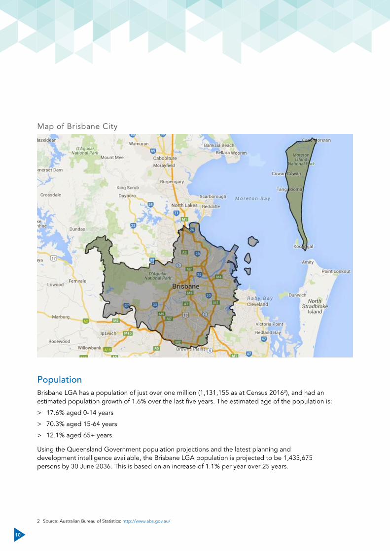
Map of Brisbane City
PopulationBrisbane LGA has a population of just over one million (1,131,155 as at Census 20162), and had an estimated population growth of 1.6% over the last five years. The estimated age of the population is:
> 17.6% aged 0-14 years
> 70.3% aged 15-64 years
> 12.1% aged 65+ years.
Using the Queensland Government population projections and the latest planning and development intelligence available, the Brisbane LGA population is projected to be 1,433,675 persons by 30 June 2036. This is based on an increase of 1.1% per year over 25 years.
2 Source: Australian Bureau of Statistics: http://www.abs.gov.au/

11
GeographyThe Brisbane LGA is bounded by the Moreton Bay Regional Council area in the north, Moreton Bay and Redland City in the east, Logan City in the south and Ipswich City and the Somerset Regional council areas in the west.
Brisbane LGA is a growing residential area, with substantial rural, industrial, recreational and parkland areas. Brisbane LGA encompasses a total land area of about 1,367 km2, including coastline, waterways, islands, national parks and state forests.
Brisbane is located on the Brisbane River floodplain with the Great Dividing Range to the west and Moreton Bay to the east. Other important waterways in Brisbane include Cabbage Tree Creek, Cubberla and Witton Creeks, Bulimba Creek, Kedron Brook, Moggill Creek, Norman Creek, Nundah/Downfall Creek, Oxley Creek, Pullen Pullen Creek, Tingalpa Creek, Breakfast-Enoggera Creek and the Wolston and Centenary catchments.
There are many important bushland reserves in Brisbane. Council manages more than 8,000 hectares of natural areas within a total park estate of more than 14,000 hectares. These natural areas comprise bushlands, wetlands, waterways and habitat corridors, which are managed for nature conservation, protection of biodiversity and for nature-based and sustainable-visitor access and use.
Climate and weatherBrisbane has a humid subtropical climate with warm-to-hot, humid summers and dry, mostly warm winters. From September to March thunderstorms are common over Brisbane with more severe events accompanied by large damaging hailstones, torrential rains, flooding and destructive winds. Brisbane lies in the tropical cyclone risk area and although cyclones have affected the city in the past they are rare. Brisbane has an average daily temperature range of 15.7-25.5 oC. On average Brisbane City receives 1,149.1 mm of rainfall each year with the heaviest rain occurring during the summer and the most extreme rainfall events associated with summer storms. The east coast of Australia is subject to two king tides each year (winter and summer) that cause higher than usual tide levels. Increased amounts of vegetation from the heavy rain seasons and a combination of potential dry summer and low humidity are risk factors associated with a potential bushfire season during the summer months if no additional rains are expected.
IndustryBrisbane City Plan 2014 (City Plan) classifies industrial land into zones and zone precincts based on the expected impacts of industry. This means industrial areas are appropriately separated from sensitive land use zones, such as residential areas, and allows for lower levels of assessment for industrial development. There are five industry zones identified in the City Plan which are:
> Low-impact industry
> Industry
> Special industry
> Industry investigation
> Extractive industry.
For more information, contact Council for a copy of City Plan or go to eplan.brisbane.qld.gov.au
12
TourismBrisbane is a popular tourist destination. In the year ending December 2015, the number of international visitors to Brisbane was 1.13 million, an increase of 13.3% driven by growth from China, New Zealand and the United Kingdom. In the same year, Brisbane had 5.75 million domestic tourists – an increase of 11.2% in domestic travel. This growth was predominantly driven by the business sector.
TransportBrisbane has an extensive public transport system consisting of bus, rail, ferry and air transport modes with regional, interstate and overseas connections. There are extensive walking and cycling pathways.
EducationAt the time of the 2016 Census, Brisbane City LGA had 618,572 persons aged 15 years and over whose highest level of schooling was Year 12 (or equivalent). This corresponded with 55.3% in Queensland.
Brisbane had 313 schools as at 30 September 20173.
3 australianschoolsdirectory.com.au
HealthBrisbane has 43 hospitals, including the following public hospitals.
> The Prince Charles Hospital, Chermside.
> The Royal Brisbane and Women’s Hospital, Herston.
> Princess Alexandra Hospital, Woolloongabba.
> Lady Cilento Children’s Hospital, South Brisbane.
Energy supplyThe electricity grid is managed by Energex and the natural gas grid by APA Group.
Water and sewerageThe water supply for Brisbane is stored in the Wivenhoe, Somerset and North Pine Dams. In Brisbane water is managed by Seqwater, which sells on distribution to Queensland Urban Utilities (QUU). QUU is responsible for water and sewerage charges, burst mains, water and sewerage leaks, pressure and leakage management, water quality and treatment, recycled water, design and connections, metered standpipes and fire hydrants, and trade waste.
Telecommunications and communication
Telstra and Optus provide high-speed internet and Pay TV cable services while the mobile phone networks are provided by Telstra, Optus, 3Mobile and Vodafone.
Emergency servicesBrisbane LGA has a large number of emergency services that are pivotal for community safety and wellbeing before, during and after any disaster event. These include:
> 23 police stations
> 22 ambulance stations
> 21 fire stations.

13
Roles and responsibilities fordisaster management
Queensland Disaster Management Arrangements
NATIONAL ARRANGEMENTS QUEENSLAND ARRANGEMENTS
Local Government Local
District
State
QueenslandGovernment
Australian Government Attorney-General’s Department
State Disaster Coordination Centre
Queensland Disaster Management Committee
District Disaster Coordination Centre
District Disaster Management Group
Australian Government Crisis Coordination Centre
Local Disaster Coordination Centre
Local Disaster Management Group
Figure 1: Queensland disaster management structure
Local government is primarily responsible for managing disasters within the local government area. The Queensland Disaster Management Arrangements (QDMA) enable a progressive escalation of support and assistance through the tiers of QDMA as required. If local governments require additional resources to manage an event, they are able to request support through the QDMA.
Queensland’s whole-of-government disaster management arrangements are based on partnerships between government, non-government organisations, commerce and industry sectors, and the local community. These arrangements recognise each level of the disaster management arrangements working collaboratively to ensure the effective coordination of planning, services, information and resources necessary for comprehensive disaster management.

14
Principles of disaster managementAll events should be managed in accordance with the strategic policy framework, the State Disaster Management Plan, and State Disaster Management Guidelines.
Council’s disaster management principles are based on the five guiding principles outlined in the Act, which form the basis of the Queensland Disaster Management Arrangements.
A comprehensive approach
A comprehensive approach is adopted throughout disaster management planning to ensure that risk reduction and community resilience are developed in unison, while maintaining effective response and recovery capabilities.
The comprehensive approach provides an overarching framework for disaster management by identifying four phases: prevention, preparedness, response and recovery.
Prevention: the taking of preventative measures to reduce the likelihood of an event occurring or, if an event occurs, to reduce the severity of the event.
Preparedness: The taking of preparatory measures to ensure that, if an event occurs, communities, resources and services are able to cope with the effects of the event.
Response: The taking of appropriate measures to respond to an event, including action taken and measures planned in anticipation of, during, and immediately after an event to ensure that its effects are minimised and that persons affected by the event are given immediate relief and support.
Recovery: The taking of appropriate measures to recover from an event, including the action taken to support disaster-affected communities in the reconstruction of infrastructure, the restoration of emotional, social, economic and physical wellbeing, and the restoration of the environment.
> Immediate short-term (relief). To support and meet the immediate needs of individuals, businesses and the community affected by an event. This may occur while essential services are being restored to the level where response agencies are no longer required to maintain them.
> Medium-term. To continue the coordinated process of supporting affected communities in the reconstruction of physical infrastructure, restoration of the economy and of the environment, and support for the emotional, social and physical wellbeing of those affected. Recovery can occur for weeks and months after the event.
> Long-term. To continue the established coordinated processes from the medium-term phase for as long as necessary after the event.
All-hazards approach
An all-hazards approach encompasses all types of natural and non-natural hazards and ensures one management system for disaster management arrangements for all of them. It involves the development of arrangements for managing the extensive range of possible effects and risks associated with disasters. The all hazards approach is useful in that the range of effects and risks can create similar consequences which require similar actions including announcing warnings, evacuation, infrastructure repairs, medical services and recovery methods. However, several risks will necessitate specific prevention measures and response and recovery actions.
All-agencies approach
An all-agencies approach ensures collaboration between all levels of government and other organisations and agencies that are required to support the four phases of the comprehensive approach.

15
Local disaster management capability
Local governments are primarily responsible for managing disaster events in their local government area. This is achieved through the establishment of the Brisbane Local Disaster Management Group and with the support (where necessary) of the District Disaster Management Group and Queensland Disaster Management Committee.
A prepared and resilient community
This approach has strong, established links between individuals, voluntary organisations and local authorities. It is acknowledged that individuals and communities can frequently help themselves and provide rapid, readily available and effective relief while external assistance may be limited due to resource capacities. When effectively integrated into disaster management arrangements, volunteer organisations are capable of providing assistance and access to resources, expertise and specialist skills. Individuals may be able to assist through knowledge of local hazards and by providing advice concerning risks. Additionally, individuals can reduce demand during responses by being informed of the risks and following advice on appropriate precautions.
Additional core principles of disaster management Council recognises other key principles of disaster management as follows.
> Disaster management is a responsibility of all levels of government including non-government organisations to work in partnership with each other and to provide a coordinated and seamless service to disaster-affected communities.
> Command, control and coordination responsibilities should be clearly articulated within the disaster management arrangements at local, district and state levels prior to a disaster or emergency.
> Disaster management arrangements must be supported by an organisational structure in
order to establish the responsibilities for all phases of the comprehensive approach.
> Planning should be developed as a result of identifying, analysing and evaluating all disaster risks, including identifying shortfalls in disaster management capability and treatment options to ensure risks are managed effectively.
> Activation of disaster management plans is vital to ensure timely and accurate response to a disaster.
> Council’s resources that exist for a day-to-day purpose should function as an extension of their core business when responding to a disaster.
> Individuals are to ensure that they comply with their workplace occupational health and safety guidelines and policies, and are responsible for their own safety, e.g. complying with Council’s Zero Harm policy.
> Efficient information management is critical for the successful management of a disaster.
Inspector-General Emergency Management (IGEM) The role of the Inspector-General Emergency Management (IGEM) was first established in 2013 following a review of police and community safety, and was formalised as a statutory position in 2014. The functions of the IGEM and the Office of the IGEM are prescribed in Sections 16C and 16H of the Act.
Functions of the IGEM include making and regularly reviewing disaster management standards, assessing entities involved with disaster management against the standards and working with entities to improve their disaster management capabilities.
IGEM is tasked with ensuring the best possible whole-of-government and whole-of-community arrangements to deal with emergencies and disasters. To support this commitment to disaster management excellence, the Office of the IGEM has developed an Emergency Management Assurance Framework.

16
Queensland Emergency Management Assurance FrameworkThe Emergency Management Assurance Framework recognises four principles underpinning effective disaster management in Queensland.
1. Leadership. Leadership at all levels is demonstrated through a commitment to a shared culture of disaster management excellence. Strategic planning, within the context of resources and risk, underpins clear decision making and planning to achieve outcomes.
2. Public safety. Queensland’s disaster management arrangements are delivered through effective disaster management groups where policy, procedure and practice all focus on safety of the public, engaging stakeholders and sharing responsibility.
3. Partnership. Everyone has a role to ensure Queensland is the most disaster-resilient state. Strategic partnerships are well-governed, drive clear roles and responsibilities, and promote true collaboration.
4. Performance. Productivity and effectiveness are measured by a combination of quality, quantity, cost, time or human relationships. Performance is monitored and analysed against standards and good practice across the spectrum of prevent, prepare, respond and recover.
The framework supports accountability and builds consistency across all levels of the disaster management arrangements and reinforces a shared responsibility for delivering better disaster management outcomes for the community.
For further information or to download a copy of the Emergency Management Assurance Framework visit igem.qld.gov.au

17
Functions of local government for disaster management
In accordance with section 80 of the Act, local governments must ensure that they maintain a disaster response capability.
Disaster response capability for a local government means maintaining disaster management plans, an appropriately trained disaster management workforce and suitable equipment in order to effectively respond to a disaster in the local government’s area.
Functions of Brisbane Local Disaster Management GroupCouncil is required under legislation to form a Local Disaster Management Group (LDMG). The Brisbane LDMG is chaired by the Lord Mayor and membership of the group includes local and state government agencies, emergency services, non-government organisations as well as critical infrastructure and service owners.
The LDMG is responsible for ensuring effective disaster management for a local government area is in place and maintained. During a disaster, the Brisbane LDMG will provide the strategic direction and coordination of Council’s response and recovery efforts for the community of Brisbane.
The Brisbane LDMG meets twice a year to regularly review and assess the disaster management plans and arrangements for Brisbane. See Section 30 of the Act for more functions of the Brisbane LDMG.
The Brisbane LDMG comprises (but is not limited to) the following members:
> APA Group (gas)
> Brisbane Airport Corporation
> Brisbane City Council
> Brisbane State Emergency Service
> Bureau of Meteorology
> Department of Communities, Disability Services and Seniors
> Department of Transport and Main Roads
> District Disaster Management Group (DDMG)
> Energex (power)
> Givit
> Maritime Safety Queensland
> Inspector-General Emergency Management
> Port of Brisbane
> Queensland Ambulance Service
> Queensland Fire & Emergency Services
> Queensland Health
> Queensland Rail
> Queensland Urban Utilities
> Red Cross
> Seqwater
> St John Ambulance
> Surf Life Saving Queensland
> Telstra
> Tzu Chi Foundation
> Queensland Police Service
Local Disaster CoordinatorThe Local Disaster Coordinator for Brisbane is Council’s Chief Executive Officer. This is a legislative role under sections 35 and 36 of the Act with the functions to:
> coordinate disaster operations for the local group
> report regularly to the local group about disaster operations
> ensure, as far as practicable, that any strategic decisions of the local group about disaster operations are implemented.
Local Disaster Coordination Centre A Local Disaster Coordination Centre (LDCC) is established to support the LDMG in implementing the activities required for response and recovery activities during an event.
The LDCC provides a focal point for Council’s coordination and prioritisation of resources and assets to support response and recovery operations in the event of a disaster or emergency. The LDCC

18
is responsible to the Local Disaster Coordinator for the implementation of Brisbane LDMG priorities.
The primary location for the LDCC is the training rooms on Level 1 of Brisbane Square, 266 George Street, Brisbane. Secondary or alternate locations are Green Square, 505 St Pauls Terrace, Fortitude Valley, South Regional Business Centre, 681 Fairfield Road, Yeerongpilly and the North Regional Business Centre, 375 Hamilton Road, Chermside.
Brisbane Local Disaster Management ArrangementsBrisbane City Council works closely with other agencies and with the community to ensure the best possible prevention, preparedness, response and recovery is in place. One of the key components of this is the idea of shared responsibility; no one person or agency can do everything, but we can work together for a stronger, more resilient Brisbane.
Council is ideally suited to manage most disaster types at the community level, based on its
understanding of local social, environmental and economic issues, and its knowledge of the city’s infrastructure. Council has comprehensive disaster management plans and is able to coordinate disaster management through its Brisbane LDMG and LDCC.
Council’s Disaster Management manages the day-to-day work of the Brisbane LDMG by developing policies, plans and processes in preparation for disaster events. This includes:
> identifying the differing needs and vulnerabilities of communities
> maintaining and enhancing relationships with external emergency service agencies to ensure a collaborative approach
> managing and maintaining the LDCC capability
> providing operational coordination for response and recovery during and after an event.
Figure 2: Brisbane Incident Management System
In
tern
al a
nd E
xter
nal A
gen
cy
Liai
son
Offi
cers
(as
req
uire
d)
Disaster M
anagem
ent• G
overnance and compliance to Q
ueensland’s Disaster M
anagement A
ct 2003• D
isaster managem
ent traning, support and guidance.
Brisbane Local Disaster Management Group (Brisbane LDMG)
Local Disaster Coordinator (LDC) CEO-BCC
Manag
erC
oo
rdinato
rD
isaster Manag
ement Staff
Incident Controller Deputy Incident Contoller
SITREP Coordinator
Crisis Communication Team City Legal
Intelligence• Flood Information
Centre• Rapid Assessment
Teams• Spatial Information
Services
Manager/Coordinator Intelligence Group
Planning• LMRTG Secretariat
(as required)
Manager/Coordinator Planning Group
Support• Administration• Contact Centre• Councillor Liaison
Manager/Coordinator Support Group
EHSOT• Emergency
Human Services Operational Team
Manager/Coordinator EHSOT
Manager/Coordinator Operations Group
Operations• WaRRS• Warehouse
RIMT North
RIMT South
RIMT Central
RIMT East
RIMT West

19
Brisbane Incident Management SystemThe Brisbane Incident Management System (BIMS) defines Council’s scalable and flexible response to emergency or disaster events.
BIMS is a comprehensive city-wide approach to disaster management, based on the Local Disaster Management Plan. It is a command and control system to logically manage and coordinate all emergency incidents from small and simple to largeand complex.
The BIMS structure ensures effective management, with the focus on resource coordination, inter-agency coordination and personnel. This is achieved through the strategic and operational levels working together in times of disaster events.
State Emergency ServiceThe Queensland State Emergency Service (SES) is a not-for-profit organisation that is supported through a partnership between the Queensland Government, local governments and SES volunteers.
The Brisbane City SES Unit is a business unit of Council reporting to the manager of Council’s Disaster Management. The unit comprises 14 groups located at eight Council locations where volunteer members meet and train.
The SES is made up of volunteers who are an integral part of Queensland’s and Council’s emergency management arrangements. The SES volunteers are trained to respond to a wide range of emergency situations that contribute to the safety of Brisbane residents and the state. Their value and importance is widely recognised throughout the community.
The primary purpose of the SES is to assist the most vulnerable members of our local communities by responding to natural disasters and other emergencies in times of need. The SES also provides agency support to the other statutory emergency services as required and in Brisbane
takes the primary role in severe weather events that impact our communities.
The major functions of the Brisbane City SES Unit are as follows.
> Storm damage clean up
− Assisting the local community with clean-up activities in private properties following the impacts of storms and flood events.
− Chainsaw-cutting of trees and other vegetation impacting houses or blocking driveway access on private property.
> Height works
− Making emergency temporary repairs to residents’ roofs.
> Agency support
− Assisting QPS with land searches for missing persons.
− Assisting QPS with marine searches for missing persons.
− Assisting QPS with forensic searches at crime scenes.
− Assisting other emergency services as required.
> Flood rescue
− Assisting in the rescue or evacuation of persons stranded in floodwaters under the direction of QPS or QFES.
> Road crash rescue
− This function is only applicable for the Moreton Island SES Group.
> Public events
− Assisting QPS and Council with crowd control and information flow at major public events like Anzac Day street parades.
> Incident management
− Providing incident management team trained staff to assist in the coordination and control of SES members during activations.

2020

21
Prevention and preparedness
Risk assessmentRisk assessment is the process of evaluating the possible consequences of identified risks, and the likelihood that those risks will occur.
Council’s risk management processes are based on Australian Standard AS/NZS ISO 31000:2009 that provides guidance and advice on how an organisation manages its risk.
There are a number of ways Council and the community can reduce risk.
What Council is doing to mitigate risk
Council understands the hazards that affect the Brisbane local government area and has a number of strategies in place to mitigate the associated risks. Below is an example of some of the ways that Council mitigates risk.
Education and awareness
Disaster response
Land use planning
and development control
Infrastructure and asset
management
Figure 3: Risk mitigation
Land use planning and development control
> City Plan including Natural Hazard overlays (bushfire, coastal hazard, flood, landslide and zoning)
> FloodWise Property Report
> Voluntary Home Purchase Scheme
> Lord Mayor’s Task Force on Suburban Flooding
> Neighbourhood planning
> Bushfire strategy and hazard reduction burns
> Building codes
Education and awareness
> Be Prepared for severe weather communication campaign
> Flood Awareness Maps
> Disaster Management training and exercising
> Community engagement activities e.g. ‘street meets’
> My Resilient School program
> Community service announcements – information, warnings and advice
> Early warning alerts
Infrastructure and asset management
> Backflow prevention devices
> Flood mitigation infrastructure
> Regularly maintained infrastructure and assets e.g. roads, waterways, depots
> Flood-resilient design e.g. ferry terminals
> Signage to warn the community of risk
> Critical infrastructure movement network
> Stormwater infrastructure network
> Planned burns
> Maintenance of sea and river walls
Disaster response
> Disaster Management Act and Disaster Management Regulation compliance
> Disaster response strategies and capabilities
> Evacuation planning
> Business continuity plans
> Memorandum of understanding with partner agencies
> Prepared and resourced Local Disaster Coordination Centre
> Local Disaster Management Group
> Trained and resourced SES
> On ground response e.g. Traffic Response Units, Rapid Response Group, Emergency Response Group and Field Services
> Internal procedures for response

22
What Council is doing to prepare for a disaster
Disaster management training and exercises
The Act directs local government to take steps to develop and maintain an effective level of capability and capacity within their organisation to prevent, prepare, respond and recover from major disaster events. Council’s disaster management training framework ensures Council’s workforce can effectively and efficiently manage disasters. The framework promotes continuous improvement and capability integration by ensuring that all disaster management stakeholders can maintain the skills and knowledge required to perform their role in all events.
Disaster management training is critical to ensure that Council’s disaster management workforce is skilled and ready for activation if required. Council delivers a range of in-house and accredited training programs and professional development opportunities, which cover leadership, disaster operations and LDCC functional capabilities.
The annual training continuum is based on three learning streams and a check phase.
> Fundamental stream. To provide an introduction to the principles and values of disaster management.
> Intermediate stream. To cater to individuals’ roles and responsibilities.
> Advanced stream. For enhanced leadership and professional development.
> Check phase. To consolidate skills and knowledge gained that will be practiced, coached and measured. This phase includes the annual exercise.
Mandatory training for each member of the disaster management workforce includes:
> Queensland Disaster Management Arrangements
> BIMS training package.
Disaster management exercises are also conducted in order to assess and validate capability. Exercises are controlled, objective-based activities used to practice, evaluate or test plans or procedures and resources. Exercises enhance the capacity and confidence of the people that participate in them.

23
Internal proceduresCouncil’s Local Disaster Management Plan is supported by a suite of internal procedures that include response, hazard and site-specific, and relief and recovery procedures.
The disaster management internal procedures document the policies and processes undertaken by Council in detail. Response procedures provide specific instructions and checklists for individual groups and roles.
What you can do to prepare for a disasterThe following information provides advice on how you can protect yourself, your family, your home and/or your business in a disaster.
Emergency or evacuation kit
Prepare an emergency kit with items including:
> a portable battery-operated radio and torch with fresh or spare batteries and bulb
> a list of Brisbane radio stations for emergency information
> a battery operated lantern
> reasonable stocks of fresh water and tinned or dried food
> a first aid kit and basic first aid knowledge
> good supplies of essential medication
> strong shoes and rubber gloves
> a waterproof bag for clothing and valuables – put valuables and certificates in the bag and put the bag in a safe place
> a list of your emergency contact numbers
> a car charger for your mobile phone
> keep insurance up-to-date.
Early warning alerts
Sign up for Council’s Early Warning Alert Service to receive free alert notices of severe thunderstorms, destructive winds and potential flooding. Alerts are distributed to Brisbane residents whose registered address/s are within the warning area as defined by the Bureau of Meteorology.
The Early Warning Alert Service app offers location-based alerts that can be received via push notifications and can be translated into other languages.
For further information on the Early Warning Alert Service visit ewa.brisbane.qld.gov.au
Understand your risk
Council has a range of free tools and information to help residents understand their risk and how to be prepared.
For more information go to brisbane.qld.gov.au and search ‘disasters and emergencies’, call Council on 3403 8888 or visit your nearest Council regional business centre.
Emergency plans
Prepare a household plan for your family and pets or for your business using the guidelines on Council’s website.
For further tools and information visit brisbane.qld.gov.au/beprepared

24
What you can do during an event
Tune into warnings
> Tune your battery-powered radio to your local radio station (e.g. ABC 612) to listen for weather and warning updates.
> Tune in to your local television station for warning updates.
> Monitor weather warning updates on Council news sites and social media channels like Facebook and Twitter.
> Monitor weather warning updates through the Bureau of Meteorology website bom.gov.au
> Listen for The Standard Emergency Warning Signal used at the beginning of serious warnings.
> Watch out for Early Warning Alert Service warnings via voice message, text, email or push notifications (for subscribed Brisbane residents)
> Watch out for Emergency Alert voice messages to your landline and text messages to your mobile telephone.
> Listen for sirens and loud announcements that emergency services may use.
> Prepare for emergency services personnel who may door-knock your area to pass on warnings.
> For non-English-speaking residents visit: qld.gov.au/emergency/dealing-disasters/prep-disaster-other-languages.html
Hazard-specific risks and what you can do to stay safe The following key hazards for Brisbane will be outlined and information provided on how to stay safe during severe weather, flooding, heatwave, bushfire, dust storms, landslide, tsunami, pandemic, earthquake and security incidents.
Severe weather (severe storms,east coast lows and cyclones)
Severe storms are a natural part of living in Brisbane’s subtropical climate with the storm season typically running from September to March each year.
Severe storms can be characterised by damaging or destructive winds, large hail and heavy rainfall that may lead to flash flooding.
East coast lows are intense low-pressure systems that occur on average several times each year off the eastern coast of Australia, in particular southern Queensland, NSW and eastern Victoria. Although they can occur at any time of the year, they are more common during autumn and winter with a maximum frequency in June. East coast lows will often intensify rapidly overnight making them one of the more dangerous weather systems.
Tropical cyclones are low-pressure systems that form over warm tropical waters and have gale force winds near their centres. While the majority of cyclone impacts are located in north Queensland, occasionally a cyclone affects areas further south down the east coast. Even cyclones that are located off the north or central Queensland coast can affect areas well to the south with heavy rain and damaging winds such as ex-Tropical Cyclone Debbie in March 2017.
What you can do to stay safe in severe weather> Before storm season begins, prepare an
emergency kit and trim tree branches well clear of your house. If your property has large trees, arrange for an arborist to check them.
> Check and clean your roof, gutters and downpipes.
> Identify loose objects in your yard and on your balcony, such as outdoor furniture and toys that will have to be put away or secured if a storm approaches.
25
> Have a supply of plastic shopping bags to use as sand bags for emergency storm water diversion. Sandbags are best filled with sand rather than dirt.
> Have masking tape and plastic sheeting or large garbage bags available for emergency rain protection.
> Sign up to Council’s Early Warning Alert Service.
As the storm approaches
> When a severe storm approaches, make sure you have your mobile phone close by, and it has a fully charged battery. Listen to a local Brisbane radio station for information and disconnect all electrical appliances. Place your vehicles undercover or cover them with tarpaulins or blankets. Secure loose items. Shelter and secure your pets and animals.
In addition, if you are preparing for a cyclone:
> secure doors and windows and draw curtains
> disconnect electrical items and outside TV aerials and turn off gas
> ensure your car is topped up with fuel and park it undercover, or cover it with tied tarpaulins or blankets.
When the storm strikes
When a severe storm strikes stay inside, keep away from windows and remain in the strongest part of the house, which is usually the bathroom. If you are
outdoors, find emergency shelter and do not stand under trees.
> You should:
− listen to your portable radio for storm updates
− if driving, stop and park away from trees, power lines and creeks
− avoid using the landline telephone during the storm.
After the storm passes
> After the storm has passed, listen to your local radio for official warnings and advice. If you need emergency assistance, phone 000 (triple zero) for life threatening emergencies or the SES on 132 500 for temporary roof repairs or sandbagging.
> If safe to do so, check your house for damage.
> Stay away from fallen power lines.
> Report all fallen power lines to Energex on 13 19 62.
> Beware of damaged buildings, trees and flooded watercourses.
> Check on neighbours.
> Do not go sightseeing.
For more information visit brisbane.qld.gov.au/beprepared

26
Flooding (creek, river, overland flow and tidal)Within Brisbane, the Brisbane River is approximately 11 km long with 38 catchment areas.
Being built on a floodplain, Brisbane can experience flooding from a variety of sources including the following.
Creek flooding happens when intense rain falls over a creek catchment. Run-off from houses and streets also contributes to creek flooding. The combination of heavy rainfall, run-off and the existing water in the creek causes creek levels to rise.
River flooding is caused by widespread, prolonged rainfall over the catchment of a river. As the river reaches capacity, excess water flows over its banks causing flooding. River flooding downstream can occur many hours after the rain has finished.
Overland flow is run-off that travels over the land during heavy rainfall events. Overland flow can be unpredictable because it is affected by localised rainfall and urban features such as stormwater pipes, roads, fences, walls and other structures. The actual depth and impact of overland flow varies depending on local conditions but it generally occurs quickly.
Tidal flooding can come from a number of sources such as higher than normal high tide and storm tide.
Higher than normal high tides frequently go unnoticed and have little to no impact. Sometimes they can cause localised flooding to bayside areas and low-lying parts of nearby suburbs. Areas connected to the foreshore and tide-affected areas of the river, tidal creeks and other waterways can also be affected.
Storm tide flooding happens when a storm surge creates higher than normal sea levels. A storm surge is caused when a low pressure system or strong onshore winds force sea levels to rise above normal levels. The impact from storm tide or storm surge is increased during high tides and can affect low-lying areas close to tidal waterways and foreshores.
For more information about the flooding risk for Brisbane see Council’s Flood Awareness Maps at cityplan2014maps.brisbane.qld.gov.au/CityPlan
What you can do to stay safe during flooding
The only way to stay safe is to stay out of floodwater. If you are travelling, get yourself a Plan B – stay in, or find a safer way to travel. The Flooded Roads Map can assist to plan a safer route from A to B.
For more information go to: floodwatersafety.initiatives.qld.gov.au
If you need to evacuate
You may be asked to evacuate, but if you plan to leave early make sure you tell the police and your neighbours. In either case, you should take the following actions.
> Pack warm clothing, essential medication, valuables, personal papers, photos and mementos in waterproof bags, to be taken with your emergency survival kit.
> Raise furniture, clothing and valuables onto beds, tables and into roof space (electrical items highest).
> Empty freezers and refrigerators, leaving doors open (to avoid damage or loss if they float about).
> Turn off electricity, water and gas.
> Take your mobile phone and charger.
> Put sandbags in the toilet bowl and over all laundry/bathroom drain-holes to prevent sewage back-flow.
> Don’t forget your pets.
> Lock your home and take the recommended evacuation routes for your area.
> Never drive into water of unknown depth and current.
27
If you stay
If you remain in your home or when you return take these precautions.
> Keep your emergency survival kit safe and dry.
> Do not eat food that has been in contact with floodwater and boil all water until supplies havebeen declared safe.
> Don’t use gas or electrical appliances that have been flood affected until they have been safety checked.
> Beware of snakes and spiders that may move to drier areas in your house.
> Avoid wading, even in shallow water as it may be contaminated.
> If you must enter shallow floodwater, wear solid shoes or boots for protection.
> Do not handle wet electrical equipment.
> Check with police for safe routes before driving anywhere and don’t enter flood water without checking depth and current.
> Keep listening to your local radio or TV station and follow all warnings and advice.
What you can do to stay safe during tidal flooding
During a higher than normal high tide it is important to listen out for weather warnings and conditions.
Strong on-shore winds can cause wave action and increase water levels. When combined with rain, higher than normal high tides can cause local drainage systems to reach capacity, increasing the chance of localised flooding.
Residents in areas prone to localised flooding due to high tides are advised to avoid driving through flood-affected roads, and avoid parking their car on the street during the event. Council encourages residents to make new neighbours aware of localisedflooding risk.
Residents are urged to take precautions if required during events. Sandbags will be made available for collection from the below depots.
> Newmarket SES Field Services, Wilston Road, Newmarket (in car park off Erneton Street).
> Balmoral Field Services, Redfern Street, Balmoral.
> Darra Field Services, Shamrock Road, Darra.
> Zillmere Field Services, Jennings Street, Zillmere.
> Lota Field Services, Herbert Street, Lota.
The sandbags are available near the footpath outside the depots.
For more information on flooding in Brisbane contact Council on 3403 8888 or visit brisbane.qld.gov.au
> Interactive Flood Awareness Map – Identify the likelihood and sources of flooding including other types of hazards that may affect your property. Learn about the extent of Brisbane’s major historic river floods. For more information visit www.brisbane.qld.gov.au/community-safety/community-safety/disasters-emergencies/be-prepared/flooding-brisbane/flood-awareness-map
> Flooding in Brisbane guide – Use this guide to help prepare for flooding and to minimise flood risk to your property.
> FloodWise Property Report – Download a FloodWise Property Report for flood information relating to building or renovating your home.
HeatwaveA heatwave occurs when there are three or more days of high maximum and minimum temperatures that are unusual for that location.4 The people most at risk from heatwaves are:
> children under four years of age
> older people
> people with a chronic condition or illness
> overweight people
> people who undertake vigorous exercise.
4 Bureau of Meteorology, bom.gov.au/australia/heatwave/about.shtml

28
What you can do to stay safe during a heatwave
Never leave a child or a pet alone in a hot car. On a typical Australian summer day, the temperature inside a parked car can be as much as 30-40 degrees higher than the outside temperature. That means on a 30-degree day, the temperature inside the car can be as high as 70 degrees.
Check on friends, relatives and neighbours, particularly the vulnerable, elderly, or people with disabilities.
Drink water regularly
> Drink two-to-three litres of water a day at regular intervals, even if you do not feel thirsty. If your fluid intake is limited on medical advice, ask your doctor how much you should drink during hot weather.
> Sports drinks do not replace water.
> Don’t drink alcohol, soft drinks, tea or coffee – they worsen dehydration.
> Eat as you normally would but do try to eat cold foods, particularly salads and fruit.
> Avoid heavy protein foods (e.g. meat, dairy products) that raise body heat and increase fluid loss.
Keep out of the heat as much as possible
> Plan your day to keep activity to a minimum during the hottest part of the day.
> If you can, avoid going out in the hottest part of the day (11am–3pm).
> If you must go out, wear lightweight, light-coloured, loose, porous clothes, a wide-brimmed hat and sunscreen, and regularly rest in the shade and drink fluids.
> Avoid strenuous activities and gardening.
Stay as cool as possible
> Wear appropriate clothing to suit the hot weather.
> Stay inside, in the coolest rooms in your home, as much as possible.
> Block out the sun during the day by closing curtains and blinds and keep windows closed while the room is cooler than it is outside.
> Open up windows and doors when there is a cool breeze, when the temperature inside rises and at night for ventilation.
> Use fans and air-conditioners at home to keep cool, or spend time in an air-conditioned library, community centre, shopping centre or cinema.
> Take frequent cool showers or baths and splash yourself several times a day with cold water, particularly your face and the back of your neck.
Monitor animals for heat stress
Animals can also be affected by heat-related illness. If you’re in charge of an animal (livestock or a pet) you have a duty of care to provide it with food, water and appropriate shelter.
For more information about heat waves, visit the Queensland Health website: health.qld.gov.au/disaster/heat

29

30
Bushfire Bushfires are unmanaged fires that burn uncontrollably. The severity of the bushfire season can be dependent on how dry the winter and spring has been.
Managing fire is vital for protecting our homes and maintaining environmental habitats. Council undertakes fire management activities such as planned burns. Planned burns are controlled fires aimed at reducing the amount of fire fuel.
South East Queensland’s bushfire season traditionally runs from August to December each year, so most planned burns in Brisbane take place between February and August.
What you can do to stay safe during a bushfire
Queensland Fire and Emergency Services (QFES) recommend that people living in bushfire-prone areas have a personal bushfire survival plan based on the Bushfire Survival Plan Guideline. For more information visit ruralfire.qld.gov.au
Public messaging and warnings will be available through Bureau of Meteorology fire weather warnings, media and radio announcements and through fire danger ratings that indicate potential danger and are displayed by QFES as low-moderate to catastrophic.
Residents are encouraged to prepare their own properties ahead of South East Queensland’s bushfire season, especially if their property backs onto or is near a bushland area. To protect your property against bushfires you should:
> ensure you have a bushfire survival plan
> clear space around buildings
> clear and remove undergrowth near buildings
> fill in any gaps around windows, door frames and eaves
> protect larger under deck areas with non-flammable screens
> rake up bark, leaves and twigs
> make sure your property has clear access for fire trucks
> be aware of any Neighbourhood Safer Places in your area.

31
Neighbourhood Safer Places
Neighbourhood Safer Places (NSP) are open spaces or buildings where people may gather, as a last resort, to seek shelter from a bushfire. Residents in bushfire prone areas need to understand where their NSPs are located, and what to do until a fire passes. The NSPs should only be used as a last resort and must be used in conjunction with the Bushfire Survival Plan guidelines.
In Brisbane the following sites have been identified through QFES as suitable NSP.
Title Type Location Latitude/longitude
Brookfield Showgrounds
Open space Brookfield Road, Brookfield Qld 4069
-27.4937656 (lat) / 152.9117367 (long)
Belmont State School
Building/ open area Old Cleveland Road, Carindale Qld 4152
-27.5025880 (lat) / 153.1154405 (long)
Ferny Grove State School
Building/ open area Finvoy Street, Ferny Grove Qld 4055
-27.4038732 (lat) / 152.9291283 (long)
Hilder Road State School
Building/ open area Kaloma Road, The Gap Qld 4061
-27.4366284 (lat) / 152.9360072 (long)
Mitchelton State School
Building/ open area Glen Retreat Road, Mitchelton Qld 4053
-27.4121536 (lat) / 152.9691451 (long)
Mitchelton State High School
Building/ open area
Samford Road, Mitchelton Qld 4053
-27.4108446 (lat) / 152.9661625 (long)
Wittonga Park Open space Hilder Road, The Gap Qld 4061
-27.4381948 (lat) / 152.9332391 (long)
Fenwick Park Open space Corner of Samford Road and Glen Retreat Road, Mitchelton Qld 4053
-27.4124540 (lat) / 152.9711192 (long)

32
Protect yourself from smoke
Smoke inhalation can cause irritation to the eyes and respiratory system, and can potentially cause people with pre-existing medical conditions such as heart and lung disorders to experience a worsening of symptoms. You can protect yourself from smoke inhalation by:
> keeping up-to-date with bushfire alerts and Council information on planned burning activities
> asking your doctor (if you have a chronic medical condition) about steps you can take to help you control your symptoms when air quality is poor
> being prepared with enough medication in the house to last you for several days
> seeking medical advice immediately if you are having trouble breathing or experience chest pain
> avoiding physical activity and staying indoors
> keeping indoor air as clean as possible by:
− keeping windows and doors closed and use draught excluders
− turning on your air-conditioner if you have one onto ‘re-circulate’ mode
− using a clean filter for the air-conditioner and have some spare filters in the house
− avoiding activities that increase indoor air pollution, such as smoking, burning candles, frying food or vacuuming.
If it is too hot in your home with the doors and windows shut, or if smoke is still leaking into the house, at risk people should arrange for shelter in another location. Heat stress is also a health risk, especially for older adults and people who are unwell.
City Plan has interactive mapping overlays that show bushfire susceptibility areas in Brisbane. For more information visit cityplan2014maps.brisbane.qld.gov.au/CityPlan/
For a list of current bushfire incidents visit ruralfire.qld.gov.au/map
Dust stormsBrisbane experienced a large dust storm (the Red Dawn dust storm) in September 2009. This storm affected Brisbane’s air quality and visibility. Dust storms may have an adverse effect on your health, particularly if you already have breathing-related problems.
What you can do to stay safe during dust storms
Dust particles in dust storms can drastically reduce visibility and can affect health and the environment.
Particles in dust storms are normally coarse and do not pose a serious health threat to the general public. Coarse dust particles generally only reach as far as the inside of the nose, mouth or throat. Some people with pre-existing breathing problems, such as asthma and emphysema, may experience difficulties.
If you have asthma or a respiratory condition and you develop symptoms such as shortness of breath, coughing, wheezing, or chest pain, follow your treatment plan. If symptoms persist, see your doctor
Protect yourself by:
> staying indoors, with the windows and doors closed
> avoiding vigorous exercise, especially if you have asthma, diabetes or a breathing-related condition.
If you have to drive:
> reduce your speed
> pull off the road if visibility is less than 100 metres
> switch off your air conditioning to reduce the amount of dust entering your car.
.

33
LandslideLandslides usually involve the movement of large amounts of earth, rock, sand or mud or any combination of these. Landslides can be caused by earthquakes, volcanoes, soil saturation from rainfall or seepage, or by human activity (e.g. vegetation removal, construction on steep terrain).
What you can do to prepare for landslides
You can protect yourself, your family and your property by doing the following.
Before occupying a building, check with Council and neighbours for the area’s history of landslides or instability. City Plan has interactive mapping overlays that show landslide susceptibility areas in Brisbane. For more information visit http://cityplan2014maps.brisbane.qld.gov.au/CityPlan/
In steep areas, look for the tell-tale signs of ground movement, such as trees tilting (down-slope), water seepage and breaks in the ground.
If outdoors always heed warning signs and avoid the tops and bases of cliffs and embankments, especially where there are signs of loose rocks or debris. Never stand or sit on rock overhangs unless you are sure they can bear your weight.
What you can do to stay safe during a landslide
If indoors shelter at the least-affected end of the building under a strong table or bench (if possible use a mattress for extra protection). Hold on firmly and stay put until all land movement has stopped.
If outdoors and a landslide threatens, move quickly from its path and keep clear of banks, trees, power lines and poles.
TsunamiMuch of Brisbane is located outside of the risk area for tsunamis, due to nearby coastal islands offering some protection from the worst of the ocean waves.
Moreton Island and some of the bayside suburbs, however, are more exposed to adverse impacts from a tsunami.
What you can do to stay safe during a tsunami
People living or working in areas potentially affected by a tsunami need to move at least 10 metres above sea level or at least one kilometre away from all beaches and the water’s edge of harbours and coastal estuaries if a tsunami warning is issued for their area.
A phone number, 1300 TSUNAMI (1300 878 6264), is available for the public to listen to tsunami warnings for Australia, and the Bureau of Meteorology’s website displays relevant tsunami warnings and information.
Pandemic influenzaPandemic influenza is a global threat that could result in widespread infection. It could have severe social and economic consequences and cause widespread disruption. Prior planning and properly coordinated response measures can minimise the impacts.
A human influenza outbreak in Queensland will be a ‘controlled notifiable condition’ under the Public Health Act 2005. The Chief Medical Officer of Queensland Health is responsible for the overall management and control in response to any public health emergency.
What you can do to stay safe during a pandemic
Brisbane residents are urged to follow the following flu precautions to limit the spread of the flu virus in the community.
> Stay at home when you are sick.
> Wash your hands frequently with soap and water or use an alcohol-based hand gel.
> Wash your hands prior to touching your eyes, nose and mouth.

34
> When coughing or sneezing, cover your mouth and nose with disposable tissues, which should be disposed of immediately.
> Don’t share items such as cigarettes, glasses or cups, lipstick, toys or anything that could be contaminated with respiratory secretions.
> Maintain at least one metre distance from people who have flu-like symptoms such as coughing or sneezing.
> Consult your doctor if you have a cough and fever and follow their instructions, including taking medicine as prescribed.
EarthquakeSeismic activity occurs from time-to-time in the Brisbane region but generally at such a low level that it has little-to-no community impact and is a low risk.
A maximum Richter magnitude of 6.5 is theoretically possible within the region. Such an event would be capable of generating highly damaging effects at the source but is an extremely unlikely event for Brisbane.
What you can do to stay safe before an earthquake
> Find out how and where to turn off power, gas and water.
> Plan with your family (or household) where you will meet if separated.
> Know your safe areas during an earthquake.
> Check your insurance policy to make sure it is adequate and that you are covered for damage caused by earthquakes.
What you can do to stay safe during an earthquake
> If indoors stay there (clear of falling debris outside).
− Keep clear of windows, chimneys and overhead fittings. Shelter under and hold onto a door frame, strong table or bench.
− In high-rise buildings, stay clear of windows and outer walls. Shelter under a desk near a pillar or internal wall.
− Do not use elevators.
> If outside keep well clear of buildings, overhead structures, walls, bridges, power lines, trees, etc.
− On a city street, shelter from falling debris under strong archways or doorways of buildings. Don’t go under awnings as they may collapse.
− If in a vehicle stop in an open area until the shaking stops.
− Beware of downed power lines and road damage, including overpasses and bridges.
− Listen to your car radio for warnings before moving.
What you can do to stay safe after an earthquake
> Turn off electricity, gas and water and do not light matches.
> Check for injuries and apply first aid.
> Check for broken water, sewerage or electrical mains.
> Do not use the telephone immediately (to avoid congestion) unless there is a life-threatening situation.
> Check for cracks and damage to your building.
> Evacuate the building if it is badly damaged and be prepared for aftershocks.
> Do not waste food and water as supplies may be interrupted.
> Listen to your local radio station and heed warnings and advice on damage and service disruptions.
> Try to avoid driving unless in an emergency.
> Do not go sightseeing or enter damaged buildings.
35
For more information visit getready.qld.gov.au/natural-disasters/earthquake or ga.gov.au/earthquakes/
Security threats/incidentsSecurity threats/incidents are an Australian Government matter that is managed locally by the Queensland Police Service. During a security incident, government and non-government organisations each have a part to play in dealing with the situation. Council’s primary responsibility and focus is on minimising the impact to residents and managing/restoring any service disruption. Council has a number of security measures and procedures in place to protect its assets and infrastructure and relevant staff participate regularly in training with other agencies.
What you can do to stay safe during a security threat/incident
The Australian National Security Hotline has been established for the public to report suspicious behaviour or activity.
In an emergency call 000.
To report suspicious behaviour or activity call the National Security Hotline on 1800 123 400.
What can I do?
> Report suspicious behaviour even if you think it is probably nothing.
> Report any unusual filming or photography of official buildings or other critical infrastructure.
> Report suspicious vehicles near significant buildings or in busy public places.
> Report suspicious or strange comings and goings from property.
> Report unusual purchases of large quantities of fertiliser, chemicals or explosives.
> Report a lifestyle that doesn’t add up e.g. paying for large purchases like flight training with cash.
> Report false or multiple identities.
> Report unattended bags.
What can I do to protect myself and others at work?
> Make sure you are familiar with the emergency and evacuation plans for your workplace. If you are unsure, ask your supervisor.
> Attend an accredited first aid course.
> If you run a business or manage a large building, review your security measures. You should also review your emergency and evacuation plans. Rehearse them, update if necessary and make sure every member of your staff knows what to do.
> Keep a careful check on garages and underground car parks so that you know whose vehicles are on your premises.
> If you have security cameras, make sure they are working properly, check that the time and date are correct and retain the recordings in case they might be of use to police in the future.
During an emergency
> Try to remain calm and reassure others.
> Check for injuries. Attend to your own injuries first so you are then able to help others.
> Ensure your family and neighbours are safe, especially children, the elderly or those who are living alone.
> Watch your television or listen to your radio for information.
> Follow the advice of emergency services.
> Call to let someone know you are safe but minimise other calls unless the situation is life-threatening, to avoid overloading phone lines.
> Use a landline to call essential contacts if mobile networks are down.
> Make sure pets are safe and have food and water.
> For more information visit nationalsecurity.gov.au

36
Response
Activation of Council’s response arrangementsActivation of the Brisbane LDMG and LDCC will be as a response to any event that has caused significant impact to the community, infrastructure and environment. Timely activation is critical for an effective response to an event.
Levels of activation
Description Triggers Brisbane City Council actions
Alert >
>
A heightened level of vigilance due to the possibility of an event in the area of responsibility.
No action is required however the situation should be monitored by someone capable of assessing the potential of the threat.
> Awareness of a hazard that has the potential to affect Brisbane LGA.
>
>
>
Disaster Management monitors events and maintains situational awareness.
Disaster Management Duty Officer (24/7) monitors events, maintains situational awareness, briefs Local Disaster Coordinator and key staff.
Manager Disaster Management may activate a response as managed through core business functions.
Lean forward
>
>
An operational state prior to ‘stand up’ characterised by a heightened level of situational awareness of a disaster event (either current or impending) and a state of operational readiness.
Disaster coordination centres are on standby; prepared but not activated.
> There is a likelihood the threat may affect Brisbane LGA.
>
>
>
>
Disaster Management issues updates and reports, provides advice to the Local Disaster Coordinator, prepares LDCC for operations.
Disaster Management Duty Officer (24/7) issues updates and reports and/or situation reports.
Manager Disaster Management may activate a response managed by the key Council business unit.
Local Disaster Coordinator may activate the LDCC.
Stand up >
>
The operational state following ‘lean forward’ whereby resources are mobilised, personnel are activated and operational activities commenced.
Disaster coordination centres are activated.
>
>
>
Threat is imminent.
Community will be or has been impacted.
Response requires coordination.
>
>
>
Disaster Management issues updates and reports, provides advice to the Local Disaster Coordinator, prepares LDCC for operations.
Local Disaster Coordinator may activate the LDCC for an event that requires a complex response from a range of stakeholders.
LDMG may meet.
Stand down
>
>
Transition from responding to an event back to normal core business and/or recovery operations.
There is no longer a requirement to respond to the event and the threat is no longer present.
>
>
>
No requirement for coordinated response.
Community has returned to normal function.
Recovery taking place.
>
>
>
Local Disaster Coordinator approves stand down of LDCC.
Final checks for outstanding requests.
Transition to business as usual.

37
Warning notification and disseminationThe Chair of Brisbane LDMG, or delegate, is the official source of public and media information and is the chief media spokesperson.
Prior to the activation of the LDCC, Disaster Management is responsible for preparing and distributing warnings and reports to the members of the LDMG and other key stakeholders.
Once the LDCC has been activated, the release of public information related to the event will be coordinated by the Crisis Communication Team in the LDCC and will be shared using social media, broadcast media and on Council’s website. Council’s Contact Centre will also be used to disseminate information.
Outside of the LDCC, the Crisis Communication Team is supported by the Corporate Communication branch and assists in the delivery of targeted, considered communication.
Council’s corporate social media channels, including Facebook and Twitter, are used to distribute approved crisis communication messaging. Residents are actively encouraged to follow Council through these mediums.
Brisbane residents who have signed-up to Council’s free Early Warning Alert Service, will receive SMS, push notifications, recorded messages or emailed alerts as required, including creek flood alerts to identified properties that may be affected by creek flooding in the following suburbs: Albion, Archerfield, Boondall, Brookfield, Coorparoo, Corinda, Deagon, East Brisbane, Greenslopes, Hemmant, Herston, Kenmore, Moorooka, Northgate, Nundah, Oxley, Rocklea, Salisbury, Windsor, Woolloongabba, Wynnum and Wynnum West.
Community service announcements Council’s Corporate Communication branch provides warning information and preparedness and recovery messaging about the event and how to stay safe through the use of community service announcements (CSAs). CSAs are short messages that are considered of service to the community. Many television and radio stations set aside time in which they broadcast CSAs free of charge and a lot of newspapers publish their version of CSAs in free community round-ups. CSAs are disseminated to the public through print and online media. The Lord Mayor communicates these messages through regular press conferences during disasters.
The community is encouraged to tune into local radio stations for up-to-date messages. Council has a longstanding agreement with ABC 612, whereby emergency messaging is broadcast with priority.
Emergency AlertEmergency Alert is the national telephone-based emergency warning system that sends messages:
> via landlines based on the location of the handset
> via mobile phones based on an individual’s billing address
> for Telstra mobile account holders based on the device’s location.
The system provides emergency service organisations with another way to warn communities in the event of an emergency such as bushfire and extreme weather events. To find out more visit emergencyalert.gov.au

38
Standard Emergency Warning ServiceStandard Emergency Warning Service (SEWS) is a wailing siren sound used throughout Australia for various emergency events of major significance, such as cyclones, flooding and severe storms. When you hear the signal on radio or television, pay careful attention to the message that follows and act immediately on the advice given. There are strict rules on the use of this warning signal in Queensland, which are outlined in the SEWS guidelines.
Disaster declarationIn accordance with Section 64 of the Act and with approval of the Minister, the District Disaster Coordinator may declare a disaster situation for the district or a part of it. As outlined in Sections 75 and 77 of the Act, the declaration confers extra powers on declared disaster officers to perform actions, give directions and control movements within the declared area.
In declaring a disaster situation, the District Disaster Coordinator is to be satisfied that a disaster has happened, is happening or is likely to happen in the disaster district. It is likely to be necessary for the District Disaster Coordinator or a declared disaster officer to exercise declared disaster powers to prevent or minimise:
> loss of human life
> illness or injury to humans
> property loss or damage
> damage to the environment.

39
Evacuation
The safety of residents is the primary driver for evacuation. QPS is authorised to order evacuation under the Public Safety Preservation Act 1986. If it’s deemed that residents need to be evacuated, Council will assist QPS and other agencies distribute warning messaging and assistance to the affected community.
There are five stages that apply to each evacuation.
1. Decision to evacuate
2. Warning
3. Withdrawal
4. Shelter
5. Return
Figure 4: Stages of evacuation
HAZARD/THREAT/IMPACT
STAGES OF EVACUATION
Decision
Warning
Withdrawal
Shelter
Return
Council is the lead agency in setting up evacuation centres within Brisbane. The establishment and location of evacuation centres will depend on the complexities of the disaster event and the location of the affected community. Council has identified a number of facilities (ranging from large centres to smaller community halls) that are suitable for use depending on the nature and location of the disaster event.
The community will be notified of the establishment and operation of an evacuation centre via a number
of sources including Council’s website, social media (Twitter and Facebook), broadcast media (612 ABC Radio and other local radio and TV stations), press releases and via Council’s Contact Centre. Council’s Disaster Management keeps a register of potential evacuation centres and works with other agencies to establish them when needed. Evacuation centres are established primarily to register evacuees and provide them with emergency human services. They should only be used for short-term accommodation as a last resort. Preferred solutions for short-term accommodation, in priority order, are as follows.
1. A destination of the person’s own choosing (relatives, friends etc.).
2. An established accommodation venue (hotel, motel, caravan park etc.).
3. An evacuation centre.
Registration People who present themselves to an evacuation centre are registered through the Red Cross Register.Find.Reunite. service for reuniting family, friends and loved ones after an emergency. For more information visit register.redcross.org.au
Evacuating animalsDomestic animals and pets may be evacuated provided their evacuation does not endanger human life and can be accomplished safely. Council has a limited capacity to provide accommodation for domestic animals at animal rehoming centres and animals may not be accepted at all evacuation centres. Residents are encouraged to have a pet emergency plan. Additional information can be found at the following sites.
> Rehoming centres: brisbane.qld.gov.au/community-safety/pets/animal-rehoming-centres
> Pet emergency plan: getready.qld.gov.au/fact-sheets/07_Pet-emergency-plan.pdf
> Livestock: daf.qld.gov.au/business-priorities/environment/natural-disaster-information

40
Reception planningThe Australian Government may make a decision to conduct reception operations. If this occurs, Brisbane may receive Australian citizens or other approved persons evacuated from disaster-affected parts of Queensland, interstate or overseas. The request to Council will be made via the LDMG (if activated) or through the Local Disaster Coordinator, who will make the decision to open reception centres. Where possible, Council will work in partnership to provide support by opening the centres and will assist other agencies in the reception.
Evacuation planning for vulnerable residentsSpecialised evacuation is sometimes required for businesses such as aged care facilities and/or nursing homes. Evacuation of these facilities can be complex and evacuation centres are unlikely to be able to meet the needs of the elderly regarding transport, bedding, high-need care and catering. Aged care facilities should have business continuity plans to address how they will manage sheltering-in-place and evacuation offsite. Often the best option is to have arrangements with other providers in the industry to share resources and support.
For more information view ‘BCP A Better Practice Guide for Disasters – Aged Care Facilities’ at disaster.qld.gov.au/Disaster-Resources/Documents/BCP-A-Better-Practise-Guide-for-Disasters-Aged-Care-Facilities.pdf
Seniors in the community can work with their carers on their own preparedness planning. For more information visit qld.gov.au/emergency/community/seniors.html
The emergency REDiPlan is a resource that provides information on the four steps to prepare for emergencies and is tailored to meet the specific needs of people with a disability. Visit qld.gov.au/emergency/dealing-disasters/rediplan.html
Isolated communitiesIf you live in a community that is vulnerable to isolation, we recommend that you have the necessary plans and arrangements in place to be able to shelter-in-location for an extended period. This includes food and essential household and personal items (including medication).
During isolation, a planned and coordinated local community response is paramount to ensuring the community remains resilient to the consequences of being isolated.
Council encourages local community groups in areas at risk of isolation to coordinate a community support centre (a community-led and operated facility that acts as a hub for sharing information and may also be used as a location for resupply). Depending on the period of isolation, or anticipated isolation, the resupply of food, medications and essential items is to be coordinated by the community support centre.
Moreton Island evacuationsMoreton Island is a popular tourist destination for campers and resort guests and is a cruise ship destination. In most events, evacuation off Moreton Island is not required. Most campers are self-sufficient and can be easily moved to coordinated safe zones or assembly areas away from the threat. This allows for flexibility and rapid evacuation to appropriate safe locations at short notice. If evacuation is required off the island, Council will manage a coordinated response to extract evacuees to muster points and arrange for transport to the mainland. Once on the mainland, evacuees will be accommodated at established Council-run evacuation centres if required.
Disaster response on Moreton Island is primarily coordinated by Disaster Management in conjunction with Queensland Parks and Wildlife Service with the support of QPS and Moreton Island SES Group. The lead agency that coordinates the response may change dependent on the type of disaster.

41
CBD evacuation
In the event of a major incident within the Brisbane CBD, always follow directions from emergency service personnel and building emergency wardens.
Map detailing Brisbane CBD boundary

42
Evacuation
> In the case of a CBD evacuation, you should self-evacuate from the CBD if it is safe to do so.
> If you cannot self-evacuate, you should follow directions from emergency personnel and/or delegated officers to access the emergency support site(s) and assembly area(s).
Emergency support sites
Emergency support sites are locations adjacent to the CBD that have been identified as suitable for the temporary management of large numbers of people who have been evacuated from the CBD.
The following areas have been identified as potential sites.
> Suncorp Stadium.
> South Bank Parklands.
> Brisbane Convention and Exhibition Centre.
> RNA Showgrounds.
These venues have been chosen because they:
> are within reasonable walking distance of the CBD area
> have sufficient facilities to provide for the short-term needs of a large number of people
> are suitable for the temporary management of people with special needs
> are adjacent to transport nodes that may be activated to transport people away from the emergency support sites.
Be prepared
> Be familiar with building evacuation plans and assembly areas
> Share official advice with others around you.
If you live in the CBD, consider:
> having a personal emergency plan and evacuation kit
> limiting the use of mobile phones in an event (as systems may be overloaded or not working)
> making provisions for pets.

43

44
RECOVERY
The role of recovery After a disaster has occurred, the recovery process involves supporting affected communities with their emotional, social and physical well-being, as well as the reconstruction of physical infrastructure and economic and environmental restoration.
The overall objective of disaster recovery is to help communities reach a point where they are sustainable, resilient and able to continue the recovery process without government assistance programs.
As recovery can be a complex and prolonged process, it is grouped into five interdependent areas: economic, building, roads and transport, environmental and human and social.
Figure 5: Recovery areas
Environmental
Building
Economic
Roads and Transport
Human and Social
Human-social recoveryHuman-social recovery is the ability of individuals, families and communities to recover from and adapt to the impacts of the disaster. Non-government organisations provide key essential services, including:
> counselling
> donation of goods
> restoration of essential services
> financial assistance
> accommodation (in extreme cases only).
Economic recoveryEconomic recovery is the ability of communities to prepare for and recover from economic impacts caused by disaster events. Council prioritises restoring common and essential services to the community and focuses on:
> key economic assets
> stimulating the renewal and growth of the economy within the area
> supporting individuals and households
> facilitating businesses, industry and regional economic recovery and renewal
> facilitating financial assistance.
Environmental recoveryEnvironmental recovery is the capacity of the natural environment to respond to a disturbance or ongoing change by resisting damage and recovering quickly. It is also the capacity of the built environment to rapidly recover to a desired level of functioning through reducing impacts of disaster events. Council focuses on:
> assessing the impact of the event on the natural environment
> rehabilitation of the natural environment
> preservation of community assets
> management and disposal of waste.

45
Building recoveryDamage to the built environment often results in disruption, inhibiting the capacity of essential services and the building sector, including housing, accommodation, education and health facilities. Considerations include:
> assessing and repairing damage to housing stock, commercial and industrial buildings and structures, rural structures and infrastructure facilities
> building safety inspections and demolition of unsafe buildings
> repair and rebuilding matters
> recovery of utilities
> restoring public schools, community and sporting facilities and playgrounds.
Roads and transportRoads and transport recovery refers to the restoration of critical infrastructure, non-critical Council and community infrastructure and privately owned infrastructure. Considerations include:
> restoration of damaged structures
> recovery of road and other transport infrastructure
> mitigation measures.
Stages of recoveryRecovery is delivered in three phases as the event passes and the response and recovery efforts are actioned. The three phases of recovery recognise the needs of the community across the various stages of an event.
Immediate short-term recovery (relief) supports the immediate needs of individuals, businesses and the community affected by a disaster or significant emergency. It may involve providing shelter, life support and essential human needs, including evacuation centres.
Medium-term recovery involves the reconstruction of physical infrastructure, restoration of the economy and of the environment, and support for the emotional, social and physical wellbeing of those affected. Medium-term recovery can occur for weeks and months after the event.
Long-term recovery can occur for months and years after the event. It continues the work of medium-term recovery and plans for a return to normal business while looking at the longer-term recovery needs of individuals and communities.
Recovery servicesCommunity recovery services aim to assist communities to recover from the effects of disasters. Council coordinates its recovery program of work to ensure affected infrastructure and assets are repaired or restored as soon as possible after the event so that essential services are returned to a proper level of functioning. Council works closely with a range of agencies and organisations to help coordinate the assistance to affected individuals, families or communities.
The Queensland Department of Communities, Disability Services and Seniors works closely with a range of organisations to provide Human and Social recovery services during a disaster. Depending on the extent of the disaster, this may include referral to support services and provision of financial assistance to residents.
> Community Recovery Hotline (1800 173 349).
> Outreach visits to impacted communities.
> Self-recovery app for people to access vital information and request assistance.
> Recovery hubs are physical locations where the community can go to access a range of services including financial assistance and support services.

46
Public health and safetySickness and injury can occur after a disaster event due to the breakdown of utilities, such as power, sewerage and water supply. This can increase the risk of disease during clean-up and recovery operations. The most common health risks during clean-ups include falls, skin lacerations, snake or spider bites, skin infections, sunburn and mosquito-borne infections.
Queensland Health offers advice on ways to reduce risk during the clean-up and recovery from a disaster at health.qld.gov.au/disaster or phone 13 HEALTH (13 43 25 84).
Coping with stressDisasters exert an emotional toll and can place strain on relationships and cause behavioural changes and strong emotional reactions. If you need help, call:
> Lifeline on 13 11 14
> Australian Red Cross on 1300 554 419 or visit redcross.org.au
> your general practitioner, local community health centre or local mental health service.
Financial assistanceResponse and recovery from an emergency/disaster event can have major financial impacts on the community. Financial assistance may be available under the Natural Disaster Relief and Recovery Arrangements (NDRRA) or State Disaster Relief Arrangements (SDRA). The Queensland Reconstruction Authority manages these arrangements.
There are various types of assistance including personal hardship, essential services grants, restoration of public assets and assistance for small businesses and primary producers. The Queensland Reconstruction Authority has factsheets and guidelines: at qldreconstruction.org.au/ndrra

47

48
Appendix 1: Acronyms and abbreviations
Acronym Explanation
ADF Australian Defence Force
BIMS Brisbane Incident Management System
BoM Bureau of Meteorology
CBD Central business district
CCTV Closed-circuit television
CEO Chief Executive Officer
Council Brisbane City Council
CSA Community service announcement
DDC District Disaster Coordinator
DM Disaster Management
LDCC Local Disaster Coordination Centre
LDMG Local Disaster Management Group
LGA Local government area
LMRTG Lord Mayor’s Recovery Task Group
NDRRA Natural Disaster Relief and Recovery Arrangements
NGO Non-government organisation
NSP Neighbourhood Safer Place
QDMA Queensland Disaster Management Arrangements
QFES Queensland Fire and Emergency Services
QPS Queensland Police Service
QUU Queensland Urban Utilities
REPA Restoration of Essential Public Assets
SDMP State Disaster Management Plan
SDRA State Disaster Relief Arrangements
SEQ South East Queensland
SES State Emergency Service
SEWS Standard Emergency Warning Signal
The Act Queensland’s Disaster Management Act 2003

49
Appendix 2: Glossary – definitions
Assessment: Survey of a real or potential disaster, ‘Serious disruption’ means:to estimate actual or expected damages and > loss of human life or illness or injury to humansto recommend prevention, preparedness and > widespread or severe property loss or damageresponse measures.
> widespread or severe damage to the Command: The direction of agency members and environment. (SDMP, the Act.)resources in the performance of the agency’s roles
Disaster district: A part of the state prescribed and tasks. Authority to command is established under a regulation as a disaster district. (The Act.) by legislation or by agreement with the agency. (Brisbane Disaster District comprises Brisbane City Command relates to agencies only and operates Council and Redland City Council.)vertically within the agency.
Disaster management: Arrangements to manage Community recovery: Focuses on those ‘people the potential adverse effects of an event, including, issues’ by which individuals, families and whole for example, arrangements for mitigating, communities are assisted to regain an acceptable preventing, preparing for, responding to and level of functioning after the disaster. It is usually recovering from a disaster. (The Act.)divided into two phases, initial and longer-term
recovery. Disaster operations: Activities undertaken before, during or after an event happens, to help reduce Community support centre: Community support the loss of human life, illness or injury to humans, centres are not evacuation centres but provide property loss or damage, or damage to the information and support to shelter-in-location in environment including, for example, activities to isolated communities. The community support mitigate the adverse effects of the event. (State centre is also a hub for sharing information with Disaster Management Plan.)the community.
District disaster coordinator: A person appointed Control: The overall direction of the activities, as a district disaster coordinator under Section agencies or individuals concerned. Control 25 of the Act. (The Brisbane District Disaster operates horizontally across all agencies, functions Coordinator is the Assistant Commissioner, and individuals. Situations are controlled.Brisbane Region, Queensland Police Service.)
Coordination: The bringing together of agencies Economic recovery: Refers to the processes and and individuals to ensure effective disaster activities that are put in place following a disaster, management, but does not include the control of to encourage the resumption of normal levels agencies and individuals by direction.of economic activity within the disaster-affected
Coordination centre: A centre established at community. The contributing agencies may state, disaster district or local level as a centre of include all levels of government, industry-based communication and coordination during response organisations and private enterprise companies.and recovery operations, in Council this is the
Emergency human services: Refers to a range Local LDCC.of activities undertaken to manage the immediate
Disaster: A serious disruption in a community, impacts of a disaster or an emergency event on caused by the impact of an event that requires a the people in the community. The functions to significant coordinated response by the state and be performed may include: evacuation, registration, other entities to help the community recover from catering, short-term sleeping accommodation the disruption. and ablutions, personal support, first aid services, volunteer coordination and management
of donations.

50
Evacuation: The planned relocation of persons the Brisbane LDMG. The LDCC Incident Controller from dangerous or potentially dangerous areas to coordinates Council’s response through the LDCC. safer areas and eventual return.
Lead agency: An organisation that, because of its Evacuation centre: Refers to a centre that provides expertise and resources, is primarily responsible for affected people with basic human needs including dealing with a particular hazard.accommodation, food and water. In addition,
Local Controller: The local controller of an SES unit to enhance the recovery process, other welfare/means the person appointed as the Local Controller recovery services should be provided.under section 134 (1) of the Fire and Emergency
Event: Any of: Services Act. (The local controller is nominated by
> a cyclone, earthquake, flood, storm, storm tide, the local government.)
tornado, tsunami, volcanic eruption or other Local Disaster Coordinator: The local disaster natural happening coordinator is appointed under section 35 of the Act
> an explosion or fire, a chemical, fuel or oil spill to coordinate the operations during a disaster for or a gas leak the local group.
> an infestation, plague or epidemicLocal Disaster Coordination Centre (LDCC):
> a failure of, or disruption to, an essential service Focal point for implementing Brisbane LDMG or infrastructure priorities and for coordinating Council’s response
> an attack against the state and recovery in the event of a disaster. The LDCC is > any other event similar to those listed above. located on Level 1, George Street Podium, Brisbane
Square.An event may be natural or caused by human acts or omissions. (SDMP.) Local Disaster Management Group (LDMG):
Chaired by the Lord Mayor, the Brisbane LDMG Hazard: A source of potential harm or a situation oversees the development and implementation with a potential to cause loss. (Emergency of the Brisbane City Council Local Disaster Management Australia 2004.) Management Plan.
Immediate evacuation: An evacuation resulting Local Disaster Management Plan (LDMP): from a hazard impact that forces immediate action, Under section 57 of the Act a local disaster thereby allowing little or no warning and limited management plan must be prepared.preparation time.
‘The plan must include provision for: Incident: Day-to-day occurrences that are
1. the state group’s strategic policy framework for responded to by a single response agency by itself disaster management for the state, and the local or in cooperation with other response agencies.government’s policies for disaster management
Infrastructure recovery: Focuses on the facilities, 2. the roles and responsibilities of entities involved installations and utilities necessary for the proper in disaster operations and disaster management functioning of the community. These include in the areapower, water supply, transport systems and 3. the coordination of disaster operations and communications. activities relating to disaster management
performed by the entities mentioned in LDCC Incident Controller: Manages Council’s paragraph (b)response to an event and is responsible for
coordinating and implementing the directions of 4. events that are likely to happen in the area

51
5. strategies and priorities for disaster Relief: The provision of immediate shelter, life management for the area support and human needs of people affected by, or
6. the matters stated in the disaster management responding to, an emergency.
guidelines as matters to be included in the plan Resources: Includes food, human resources, any 7. other matters about disaster management horse or other animal, vehicle, vessel, aircraft, plant,
in the area the local government considers apparatus, implement, earthmoving equipment, appropriate.’ (The Act.) construction equipment or other equipment of any
Mitigation: Measures taken in advance of an event kind or any means of supplying want or need.
aimed at decreasing or eliminating its impact on Response: In relation to a disaster, includes the society and environment. process of combating a disaster and of providing
Neighbourhood Safer Places (NSP): A local open immediate relief for persons affected by a disaster.
space or building where people may gather, as a Risk: Expected losses (of lives, persons injured, last resort, to seek shelter from a bushfire. property damaged and economic activity
Planning: The process of developing a system for disrupted) due to a particular hazard for a given
coordinating disaster response and establishing area and reference period. Based on mathematical
priorities, duties, roles and responsibilities of calculations, risk is the product of hazard and
different individuals and organisations, including vulnerability.
actual state of preparedness. Shelter in place: People not at immediate risk but
Preparedness: Action designed to minimise loss affected by or in the proximity of an incident will
of life and damage, and to organise and facilitate generally shelter in place in the first instance and
timely and effective rescue, relief and rehabilitation await advice from emergency services.
in case of disaster. Preparedness is concerned with: Voluntary organisation: Non-governmental > understanding the threat organisations or agencies, some possessing
> forecasting and warning personnel trained to assist when disaster strikes. Some have capabilities extending from local to
> educating and training officials and the national and international levels.population establishing organisations for the management of disaster situations including Vulnerability: The degree of loss that could result preparation of operational plans, training relief from a potentially damaging phenomenon, or groups, stockpiling supplies and earmarking the extent to which a country, area, community, necessary funds. or structure risks being damaged by a disaster.
(Zamecka and Buchanan.) The conditions Prevention: In relation to a disaster, includes the determined by physical, social, economic and identification of hazards, the assessment of threats environmental factors or processes, which increase to life and property, the taking of measures to the susceptibility of a community to the impact reduce or eliminate potential loss to life or property of hazards. (National Emergency Risk Assessment and protect economic development. Guidelines.)
Recovery: The taking of preventative measures Warning: The dissemination of messages signalling to recover from an event, including action taken imminent hazard, which may include advice on to support disaster-affected communities in the protective measures.reconstruction of infrastructure, the restoration of emotional, social, economic and physical wellbeing, and the restoration of the environment. (SDMP.)

52
Appendix 3: Emergency contacts
Issue Contact
Life-threatening emergencies Triple zero (000) for police, fire or ambulance services
Report a fire Triple zero (000) for fire
Non-emergency situations Qld Police – 13 14 44Qld Ambulance – 13 12 33
SES for flood or storm damage State Emergency Service (SES) – 132 500
Council-related emergencies/enquiries
Brisbane City Council – (07) 3403 8888 (24 hours) brisbane.qld.gov.au
Water supply emergencies Queensland Urban Utilities – 13 23 64
Fallen power lines Energex – 13 19 62Stay away from fallen power lines and alert people of the danger.
Power outages Energex – 13 62 62
Telecommunication problems Telstra – telstra.com.au – 13 22 03Optus – optus.com.au – 13 13 44Vodafone – vodafone.com.au – 1300 650 410
Gas emergencies APA Group – 1800 427 532
Health and hospital information – non-emergency situations
Queensland Health – 13 HEALTH (13 43 25 84)
School closures Contact your child’s school directly or visit education.qld.gov.au
Road and traffic conditions Transport and Main Roads – 13 19 40 or visit 131940.qld.gov.au
Support and financial assistance Community Recovery Hotline on 1800 173 349 or visit qld.gov.au/community/disasters-emergencies
Animal emergencies Wildlife Hotline – 1300 130 372 RSPCA – 1300 264 625Disaster support for livestock owners – daf.qld.gov.au/environment/disaster-and-emergency-assistance
Biosecurity Animal and plant biosecurity health information, alerts and advice – daf.qld.gov.au/biosecurity
National Relay Service (for people with hearing/vision impairment)
TTY voice calls – 133 677 Speak & listen – 1300 555 727 SMS relay – 0423 677 767
Lifeline 24/7 help hotline – 13 11 14
Red Cross Register.Find.Reunite register.redcross.org.au
Volunteering volunteeringqld.org.au
National Security Hotline 1800 123 400
Poisons Information 13 11 26

Brisbane City Council GPO Box 1434
Brisbane Qld 4001
Every effort is made to ensure that information is correct at time of printing
brisbane.qld.gov.au 3403 8888
/BrisbaneCityCouncil@brisbanecityqld@brisbanecitycouncil
CA16-422356-05-3991© 2018 Brisbane City Council
Printed on sustainable paper