breeding wader territories flight 7curlew 7 curlew
TRANSCRIPT

77
77
77
77
77
7 777
!A
!A
!A
!A
!A
!A
!A
!A
!A
!A
!A
!A
Issue Drawn by
Scale
Date
Site
Project No.
Title
Client
A LNF
November 2016
Hopsrig Wind Farm Ltd
Hopsrig Wind FarmLangholm
Figure 6.9:Breeding Waders2015
UK12-22427
@ A31:17,500
Key
Site Boundary
!A Turbine Location
500 m Study AreaBreeding WaderTerritories
Curlew
SnipeFlight77Curlew
ObservationCurlew
Oystercatcher
Snipe
Reproduced from Ordnance Survey Map Data with the permission of the Controller of HMSO, Crown Copyright Reserved Licence No. ES 100022432
Path
: S:\P
rojec
t GIS
\202
0\Ho
psrig
\ES_
O_Fig
6.9_
BW_2
016_
HPS.
mxd
0 1 km
N

!A
!A
!A
!A
!A
!A
!A
!A
!A
!A
!A
!A
Issue Drawn by
Scale
Date
Site
Project No.
Title
Client
A LNF
November 2016
Hopsrig Wind Farm Ltd
Hopsrig Wind FarmLangholm
Figure 6.10:Breeding Waders2016
UK12-22427
@ A31:17,500
Key
Site Boundary
!A Turbine Location
500 m Study AreaBreeding WaderTerritories
Curlew
SnipeObservation
Curlew
Snipe
Reproduced from Ordnance Survey Map Data with the permission of the Controller of HMSO, Crown Copyright Reserved Licence No. ES 100022432
Path
: S:\P
rojec
t GIS
\202
0\Ho
psrig
\ES_
O_Fig
6.10
_BW
_201
6_HP
S.m
xd
0 1 km
N

77
77
77
77
!A
!A
!A
!A
!A
!A
!A
!A
!A
!A
!A
!A
Issue Drawn by
Scale
Date
Site
Project No.
Title
Client
A LNF
November 2016
Hopsrig Wind Farm Ltd
Hopsrig Wind FarmLangholm
Figure 6.11:Winter WalkoverRecords 2015/2016
UK12-22427
@ A31:17,500
Key
Site Boundary
!A Turbine Location
500 m Study AreaFlight Activity77Goshawk
77Pink-footed Goose
77Red KiteObservation
Curlew
Woodcock
Reproduced from Ordnance Survey Map Data with the permission of the Controller of HMSO, Crown Copyright Reserved Licence No. ES 100022432
Path
: S:\P
rojec
t GIS
\202
0\Ho
psrig
\ES_
O_Fig
6.11
_WW
o_20
15_2
016_
HPS.
mxd
0 1 km
N
7777
77
77
77
77
77
77
77
77
77
77
77
77
!A
!A
!A!A
!A
!A
!A
!A
!A
!A
!A
!A
Issue Drawn by
Scale
Date
Site
Project No.
Title
Client
A LNF
November 2016
Hopsrig Wind Farm Ltd
Hopsrig Wind FarmLangholm
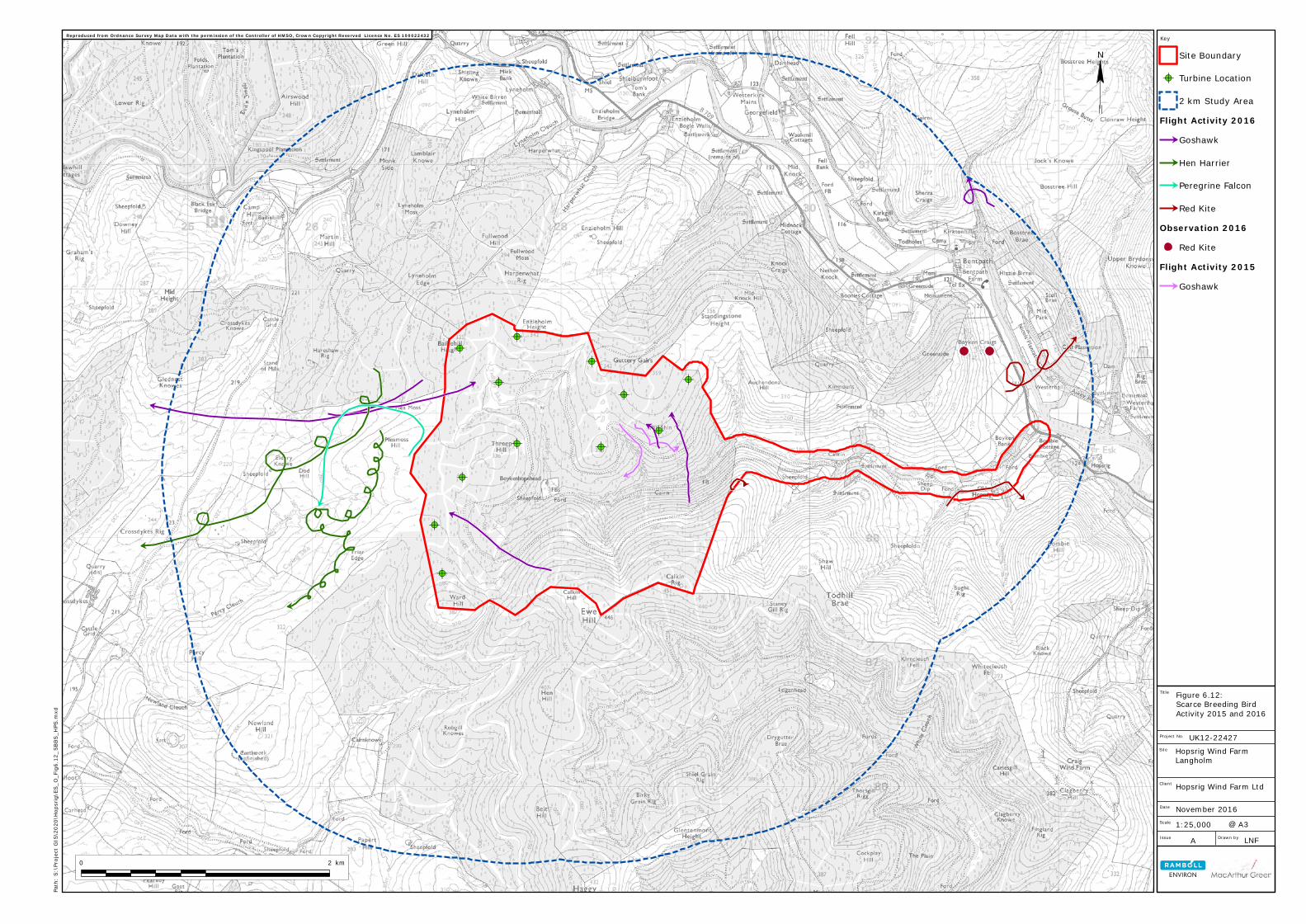
Figure 6.12:Scarce Breeding BirdActivity 2015 and 2016
UK12-22427
@ A31:25,000
Key
Site Boundary
!A Turbine Location
2 km Study AreaFlight Activity 201677Goshawk
77Hen Harrier
77Peregrine Falcon
77Red KiteObservation 2016
Red KiteFlight Activity 201577Goshawk
Reproduced from Ordnance Survey Map Data with the permission of the Controller of HMSO, Crown Copyright Reserved Licence No. ES 100022432
Path
: S:\P
rojec
t GIS
\202
0\Ho
psrig
\ES_
O_Fig
6.12
_SBB
S_HP
S.m
xd
0 2 km
N

Figure 6.13: CONFIDENTIAL Scarce Breeding Nest Locations: 2015 and 2016
Contained within Confidential Volume available on request
!!
! !!
! !!
!!
! !
!(!(!(
!(!(!(
!(!(!(!(!(
!(!(!(!( !(!(
!(!(!(
!(!(
!(!( !(
!(!(!( !(
!(!(!(
!(
!(
!(
!(!(
!(!( !(
!(!(
!(
!(!(!(
!(!(!(
!(!(
!(!(
!(
!(
!(!( !(
!(
!( !(!( !(
!(!(
!(!(
!(!(!(!(!(
!(
!(
!( !(!(!(!( !(!(!(!(
!(
!(!(!(!(!(!(!(
!(!(!(!(!(
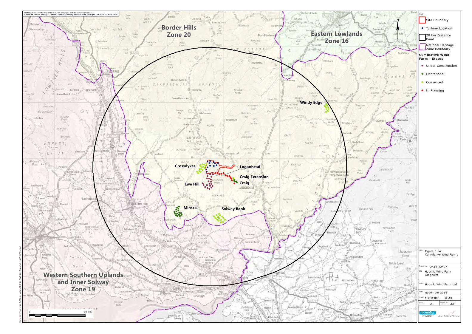
Craig Extension
Eastern LowlandsZone 16
Western Southern Uplandsand Inner Solway
Zone 19
Border HillsZone 20
Craig
Minsca
Crossdykes
Ewe Hill
Solway Bank
Windy Edge
Loganhead
Issue Drawn by
Scale
Date
Site
Project No.
Title
Client
A LNF
November 2016
Hopsrig Wind Farm Ltd
Hopsrig Wind FarmLangholm
Figure 6.14:Cumulative Wind Farms
UK12-22427
@ A31:200,000
Key
Site Boundary! Turbine Location
20 km DistanceBandNational HeritageZone Boundary
Cumulative WindFarm - Status
!( Under Construction!( Operational!( Consented!( In Planning
Contains Ordnance Survey data © Crown copyright and database right 2016© Scottish Natural Heritage. Contains Ordnance Survey data © Crown copyright and database right 2016
Path
: S:\P
rojec
t GIS
\202
0\Ho
psrig
\ES_
O_Fig
6.14
_Cum
ulativ
eWF_
HPS.
mxd
0 10 km
N