bowers marsh habitat creation scheme - iemascheme at bowers marsh – the rspb veolia bowers marsh...
TRANSCRIPT

i
������������
Bowers Marsh Habitat Creation Scheme
Volume I: Non-Technical Summary
RSPB
22 December 2009 Final Draft 9V1356
ii
Document title Bowers Marsh Habitat Creation Scheme
Non-Technical Summary
Status Final Draft
Date 22 December 2009
Project name Bowers Marsh
Project number 9V1356
Client RSPB
Reference 9V1356/R/303950/Lond
4 Dean's Yard
Westminster London SW1P 3NL
United Kingdom
+44 (0)20 7222 2115 Telephone +44 (0)20 722202659 Fax
[email protected] E-mail www.royalhaskoning.com Internet
����� �����������
��� ��������
Drafted by Sean McNulty
Checked by Sian John
Date/initials check 22/12/09 SAJ
Approved by Sian John
Date/initials approval 22/12/09 SAJ

iii
������������

iv
CONTENTS Page
1 INTRODUCTION 1
2 THE STUDY AREA 1
3 DESCRIPTION OF PROPOSED WORKS 3 3.1 Proposed Works 3
3.1.1 Reservoir 3 3.1.2 Creation of an interconnected ditch and scrape system 3 3.1.3 New water vole habitat 5 3.1.4 Saline lagoon 5 3.1.5 Access Track 5 3.1.6 Footpaths and changes to the PRoW 6 3.1.7 Viewing points and visitor facilities 6 3.1.8 Removal of wooded areas 7
3.2 Construction Phase 7
4 NEED FOR THE PROPOSED DEVELOPMENT 9
5 THE ENVIRONMENTAL IMPACT ASSESSMENT PROCESS 10 5.1 EIA and project legislation 10 5.2 The EIA Process 10
6 CONSULTATION 12
7 NATURE CONSERVATION DESIGNATIONS 13
8 HYDRODYNAMICS 15 8.1 Baseline environment 15 8.2 Predicted impacts and mitigation 16
9 COASTAL PROTECTION AND FLOOD RISK 18 9.1 Baseline environment 18 9.2 Predicted impacts and mitigation 19
10 SOIL QUALITY, HYDROLOGY AND HYDROGEOLOGY 21 10.1 Baseline environment 21 10.2 Predicted impacts and mitigation 23
11 ESTUARINE WATER QUALITY 25 11.1 Baseline environment 25 11.2 Predicted impacts and mitigation 25
12 MARINE ECOLOGY 27 12.1 Baseline environment 27 12.2 Predicted impacts and mitigation 28

v
13 TERRESTRIAL AND FRESHWATER ECOLOGY 30 13.1 Baseline environment 30 13.2 Predicted impacts and mitigation 31
14 ORNITHOLOGY 33 14.1 Baseline environment 33 14.2 Predicted impacts and mitigation 34
15 NAVIGATION 36 15.1 Baseline environment 36 15.2 Predicted impacts and mitigation 36
16 ARCHAEOLOGY 37 16.1 Baseline environment 37 16.2 Predicted impacts and mitigation 37
17 LANDSCAPE AND VISUAL SETTING 40 17.1 Baseline environment 40 17.2 Predicted impacts and mitigation 40
18 TRAFFIC AND ACCESS 43 18.1 Baseline environment 43 18.2 Predicted impacts and mitigation 43
19 NOISE AND VIBRATION 45 19.1 Baseline environment 45 19.2 Predicted impacts and mitigation 45
20 AIR QUALITY 47 20.1 Baseline environment 47 20.2 Predicted impacts and mitigation 47
21 TOURISM, RECREATION AND SOCIO-ECONOMICS 49 21.1 Baseline environment 49 21.2 Predicted impacts and mitigation 49
22 WATER FRAMEWORK DIRECTIVE 51 22.1 Baseline environment 51 22.2 Predicted impacts and mitigation 51
23 HABITATS REGULATIONS SIGNIFICANCE TEST 52
24 CONCLUSIONS AND RECOMMENDATIONS 53 24.1 Summary of Impacts and Mitigation Measures 53


- 1 -
1 INTRODUCTION
The Royal Society for the Protection of Birds (RSPB) has obtained funding through the Parklands Programme (a Government initiative to re-invigorate and improve the Thames Gateway area economically, socially and environmentally) for a habitat creation and enhancement scheme within the South Essex Marshes. The proposed habitat creation scheme at Bowers Marsh – the RSPB Veolia Bowers Marsh Reserve – forms one part of this wider initiative. This Non Technical Summary (NTS) provides a general overview of the findings of the Environmental Impact Assessment (EIA) process, as reported in the Bowers Marsh Habitat Creation Scheme Environmental Statement (ES). The NTS aims to use plain language – where possible – to describe the background and need for the project, and how it complies with the current planning and regulatory framework. It outlines the various options for the proposed development, describes the main beneficial and adverse environmental impacts predicted and the key mitigation measures which are to be put in place to reduce or prevent any adverse residual impact. The ES and NTS have both been prepared in accordance with the Town and Country Planning (Environmental Impact Assessment) (England and Wales) Regulations 1999.
2 THE STUDY AREA
Bowers Marsh is located on the northern shore of the Thames Estuary (see Figure 2.1) and is linked to the Thames itself via a number of creeks – East Haven Creek, Benfleet Creek and Vange Creek. It is surrounded by the communities of Basildon to the north, North Benfleet to the north-east and Canvey Island to the east. It is separated from the community of Corringham to the west by Vange Marsh. To the south and adjoining the proposed Bowers Marsh Nature Reserve is the Pitsea Landfill Site; although now separated, historically the two areas would have been joined via the drainage ditch system and the original water course. The landfill, owned by Veolia, will remain operational until 2017 and will then undergo a period of restoration until 2023. Further to the south is the Coryton Oil Refinery. The study area for the EIA varies according to the type of impact being assessed and the potential receptors. The study area for each potential impact is, therefore, described for the relevant environmental receptor (e.g. ecology or archaeology) under consideration in the different chapters of the ES and summarised in this NTS.

- 2 -
Figure 2-1 Bowers Marsh Site Location

- 3 -
3 DESCRIPTION OF PROPOSED WORKS
3.1 Proposed Works
The proposed works consist of the following key elements (See Figure 3.1):
• A reservoir;
• Creation of an interconnected ditch and scrape system;
• New water vole habitat;
• A saline lagoon;
• An access track;
• Footpaths and changes to Public Rights of Way (PROWs);
• Viewing points and visitor facilities;
• Removal of wooded areas.
Each one is considered in turn in the subsections below.
3.1.1 Reservoir
Freshwater input onto the site originates both from direct rainfall and also from the catchment area surrounding it. Two main ditches carry the freshwater input down onto the site. From this point on this watercourse is designated as a ‘main’ river by the Environment Agency and travels down Church Road and under the railway bridge, continuing southwards towards Bowers Marsh.
The proposed reservoir will be approximately 20 ha in area, will be in a central position within the Reserve (see Figure 3.1) and will receive freshwater input from the main river described above. It will act as a storage facility during the wetter months and then pump out the stored water onto the Bowers Marsh site to its west and east during the drier months, more specifically, during April, May and June when breeding birds will be on the Reserve. This will balance water losses from evaporation and seepage. A weir system at the north-easterly end of the reservoir will allow excess water to flow over the reservoir spillway and make its way seaward around the north of the site and eventually out into the East Haven Creek via the existing Rookery Barn Sluice and current Main river route (see Figure 2.2). There will be a number of islands within the reservoir of varying shapes and sizes, designed to maximise bird use and provide an interesting vista to the public as they travel along the path around the reservoir.
3.1.2 Creation of an interconnected ditch and scrape system
The vast majority of the land on the Bowers Marsh Reserve will become part of an interconnected ditch and scrape system (see Figure 3.1). This new drainage system will be excavated as detailed below and will require the filling in of the majority of the existing ditches on the site.

4
Figu
re 3
-1 P
ropo
sed
Hab
itat C
reat
ion
Pro
posa
ls

5
Large creeks (creek channels) There will be approximately four large creeks on the site, one to the west of the reservoir and three on the eastern side of the site (see Figure 3.1). The one to the west will be joined to the west side of the reservoir. The three on the eastern side will be orientated towards the existing medieval bank (a remnant of an older sea wall). The rationale behind the orientation of the three creeks on the eastern side of the site is that, should a decision be taken to set back the coastal defences in the future, the creek system established during this habitat creation project would naturally fit with any new intertidal creek system that would develop.
Carrier channels Branching off from the larger creeks there will be a series of carrier channels. These will be narrower in width but the same depth as the creek channels.
Foot drains Branching off from the carrier channels will be a series of foot drains. These will be shallower than the carrier channels, at about 700mm depth. The width of the channels will vary when ‘full’ but the foot drains will generally be narrower than the carrier channels.
Pools Around the site, where appropriate, a number of shallow pools will be excavated. These will be connected to the system of channels described above. While some pools will remain directly connected to the ditch network at all water levels, a number will be cut off from the ditch network at lower water levels.
3.1.3 New water vole habitat
Along the southern periphery of the site there will be a new ditch designed and excavated specifically to provide replacement habitat for the indigenous water vole population. The ditch will be connected to the new ditch and scrape system. It will travel along the whole of the boundary between the Bowers Marsh site and the Pitsea Landfill Site, a distance of approximately 3.5 km (see Figure 3.1).
3.1.4 Saline lagoon
The saline lagoon will be located on the east side of the Bowers Marsh site (see Figure 2.2). The lagoon will be connected to the East Haven Creek via regulated tidal exchange (RTE). It will be necessary to excavate a small amount of saltmarsh/intertidal area from in front of the inlet/outfall structure to allow unhindered two-way movement of seawater from the creek through the pipes and into the saline lagoon. It will also be important to maintain the current level of flood protection during construction of the saline lagoon and RTE.
3.1.5 Access Track
An access track is proposed which will travel the full length of the site boundary between Bowers Marsh and the Pitsea Landfill Site (see Figure 2.2). This will be constructed on

6
the Bowers Marsh side of the new water vole ditch. The second section of the access track will run east from the reservoir to the edge of the Bowers Marsh site, where it meets the East Haven Creek.
3.1.6 Footpaths and changes to the PRoW
Footpaths and bridleways A circular bridleway, allowing access by foot, horse or bicycle, supplemented by a number of shorter footpaths is envisaged within the Reserve. The bridleway and footpaths will all be 3 m wide and slightly elevated where necessary to avoid the route becoming waterlogged in places. The surface of all visitor routes will be covered with granite fines. Kissing gates and farm access gates will be located across the site as necessary.
In order to allow public access into the Reserve, the RSPB wish to utilise the existing PRoWs that are on the site, as well as extend them to create a number of RSPB permissive paths.
3.1.7 Viewing points and visitor facilities
Viewing points There will be six viewing points strategically located across the site (see Figure 2.2). These will enable visitors to view the birds in specific habitats, as follows:
• Viewing point 1: View out across the ditch and scrape system;
• Viewing point 2: View out across the reservoir and islands;
• Viewing point 3: View out across the reservoir, islands, the large creek and out across the ditch and scrape system to the east;
• Viewing point 4: View out across the reservoir and large creek;
• Viewing point 5: View out across saline lagoon, islands and south across ditch and scrape system with large creeks also in view; and
• Viewing point 6: View out across saline lagoon and islands.
The viewing points will be in the form of hides with the lower levels surrounded by embankments of earth. The hides will be of varying sizes, designed to accommodate different numbers of visitors, and may be round at some viewing points and oblong in others, depending on the hides position in relation to where birds will be seen.
Visitor facilities There will be limited visitor facilities on the site in the short to medium term. The RSPB intend to revisit this once the Reserve is operational but, at this point in time, there will be no visitor centre or toilet facilities. There will, however, be a visitor car park located close to the entrance of the Reserve, near Great Mussels Farm. This will accommodate up to 120 cars and include an area for bicycle parking. Visitor information boards will be

7
strategically placed around the site, including in the car park area, and sign posts will be placed at junctions along the circular route to aid visitor orientation.
3.1.8 Removal of wooded areas
There are three small wooded areas on the Bowers Marsh site. It is proposed that the areas identified as Wooded Areas 2 and 3 on Figure 11.1 in the ES will be removed during the construction phase due to the positioning of the proposed new ditch and scrape system.
3.2 Construction Phase
The Construction phase of the project consists mainly of earthworks and is planned for July 2010 to March 2011 inclusively. It is envisaged that construction will involve excavations, stockpiling of material, placing and compacting soils for new embankments, plus water control structures.


9
4 NEED FOR THE PROPOSED DEVELOPMENT
The proposed works are deemed by the RSPB to be important to ensure the best long term management of the conservation interest on the site. The Parklands Programme is one of the key areas of investment identified in the Thames Gateway Delivery Plan published in 2007 (Dept for Community and Local Government (DCLG), 2007). The Thames Gateway Delivery Plan built on the initiative of the Thames Gateway Interim Plan, published in 2006 (DCLG, 2006). The interim plan set out a programme of regeneration focused on the needs and opportunities for local people and communities, as well as the wider regional and national economy. It recognised that the success of the Gateway is key to the wider UK economy and ensuring that London remains a global capital. Following on from the interim plan, the delivery plan committed over £9 billion of cross-Government investment in the Gateway. It set out the programme of investment around key objectives to not only boost the economy of the Gateway, but also to improve the quality of life in the area. One such key objective was that of enhancing the natural and urban environment across the Gateway through major investment in the Thames Gateway Parklands. The Parklands Programme itself aims “to provide a network of accessible, high quality and sustainable landscapes and waterways, which capitalises on existing natural, built, historic and cultural assets. It supports their conservation, enhancement and ongoing use” (Parklands Vision, 2008). Further to this the intention is that Parklands will “boost Thames Gateway’s rich biodiversity, strengthen its character and identity and transform perceptions of the area into being a great place to live, work and invest in”. As part of the Parklands Vision, the RSPB was awarded funding of £5.2 million for the creation of a new 1500 ha green landscape at the heart of the South Essex Marshes at Vange Marshes, West Canvey Marsh and Bowers Marsh. A key element of the projects is to ensure that they are at the heart of the Thames Gateway communities and allow people to get close to wildlife. Bowers Marsh forms part of the South Essex Marshes project and is, therefore, integral to the success of the Parklands Vision and to the Thames Gateway Development Plan.

10
5 THE ENVIRONMENTAL IMPACT ASSESSMENT PROCESS
5.1 EIA and project legislation
The requirement for EIA is established by European Directive 85/33/EEC (as amended by 97/11/EC) on the assessment of the effects of certain public and private projects on the environment (the EIA Directive). The EIA Directive is implemented in the UK through various statutory instruments. Of relevance to this project, the EIA Directive has been enacted through the Town and Country Planning (Environmental Impact Assessment) (England and Wales) Regulations 1999. A range of planning polices have also been identified that are applicable to this project at a national, regional and local level. These were considered during the EIA process.
5.2 The EIA Process
EIA is a tool for examining and assessing the potential impact and effects of development on the environment. Essentially it is a process that examines the environmental consequences of development actions before they go ahead (i.e. are granted planning permission). The following stages are typically included in an EIA:
• ‘Screening’ (i.e. determining whether a development proposal needs an EIA).
• ‘Scoping’ (i.e. determining the issues that the EIA should address in detail).
• Preparing the ES itself (i.e. establishing baseline data, evaluating potential impacts etc.).
• Reviewing and evaluating the ES to ensure it contains specified information.
• Formally submitting the ES and for public (and effected parties) scrutiny.
In support of their Planning Application, the RSPB determined to undertake an EIA of the potential environmental impacts of the proposed development. A Scoping Report was prepared for the EIA and a request for a Scoping Opinion under the EIA Regulations 1999 made to Basildon District Council. A formal Scoping Opinion was received in November 2009 and was taken into account in the preparation of the ES. Impact identification and evaluation was carried out via a number of methods and techniques, including reference to guidelines, research, literature review and consultation, as agreed during the scoping exercise. Significance levels have been assigned to each impact identified in order to provide a consistent approach for their consideration and evaluation. The definitions used for assigning significance (unless indicated otherwise) are set out in Table 5-1.

11
Table 5-1 Terminology for classifying environmental impacts
Significance of impact Definition
Major adverse The impact gives rise to serious concern and it should be considered as unacceptable.
Moderate adverse The impact gives rise to some concern but is likely to be tolerable depending on scale and duration.
Minor adverse The impact is undesirable but of limited concern.
Negligible The impact is not of concern.
No impact There is an absence of one or more of the following: impact source, pathway or receptor.
Minor beneficial The impact is of minor significance but has some environmental benefit.
Moderate beneficial The impact provides some gain to the environment.
Major beneficial The impact provides a significant positive gain.
As part of the impact assessment process, each of the key environmental receptors listed below is considered, in turn, in the context of the RSPB’s proposals in Chapters 7 to 23:
• Nature Conservation Designations;
• Hydrodynamics;
• Coastal Protection and Flood Risk;
• Soil quality, Hydrology and Hydrogeology;
• Estuarine water quality;
• Marine Ecology;
• Terrestrial and Freshwater Ecology;
• Ornithology;
• Navigation;
• Archaeology and Cultural Heritage;
• Landscape and Visual Setting;
• Traffic and Access;
• Noise and Vibration;
• Air quality;
• Tourism, Recreation and Socio-economics;
• Water Framework Directive; and
• Habitats Regulations Significance Test.

12
6 CONSULTATION
Consultation is an important element of the environmental assessment process. The main aim of consultation is to identify, at an early stage, the specific concerns of all of the bodies and organisations with an interest in the area of the scheme. As part of the EIA investigations, a number of organisations and individuals (the ‘consultees’) with a direct interest in the proposed scheme or the study area were contacted for their local knowledge, comments and concerns. For example, the following organisations were consulted:
• Basildon District Council;
• Natural England;
• Environment Agency;
• The Port of London Authority (PLA);
• Veolia;
• The Essex Wildlife Trust;
• Essex County Council Historic Environment Management Team (ECC HEMT); and
• Essex County Council South Area Highways. In response to the Scoping Report (Royal Haskoning, 2009) sent to Basildon District Council on the 25th August 2009, a formal Screening / Scoping Opinion was issued on 17th November 2009. The RSPB has also undertaken consultation with its neighbours and with the public. Public consultation commenced with an unmanned display set up in the foyer of the Basildon Centre between the 13th and 23rd July 2009. Following on from this, a two day walk-in presentation was held at Pitsea Hall Mount on 24th and 25th July 2009. Questionnaires were available for completion by visitors to the display. A range of questions were posed, including what the name of the Reserve should be to what further amenities should be considered for the site. Three guided walks across the marshes have also been held since June 2009, where approximately 25 people have attended. The consultation display (including questionnaires) was then placed in the RSPB visitor centre at Wat Tyler Park from 27th July to 14th August. The display will remain in place for the foreseeable future. A second round of public consultation is planned by the RSPB in January 2010; with a drop in event is planned for 23rd January at Pitsea Leisure Centre. Following this, a display will be shown at Wat Tyler Park from 25th January through to the end of the planning determination period. Additional guided walks for members of the public will be offered leading up to and following the planning decision date.

13
7 NATURE CONSERVATION DESIGNATIONS
Bowers Marsh lies within and adjacent to a number of international and national sites of conservation importance. These are:
• Thames Estuary and Marshes Special Protection Area (SPA) and Ramsar site;
• Benfleet and Southend Marshes SPA and Ramsar site;
• Holehaven Creek Site of Special Scientific Interest (SSSI);
• Pitsea Marshes SSSI; and
• Bowers Marsh Local Wildlife Site.
In addition to the above it is recognised that there is a functional linkage between Holehaven Creek SSSI and the Thames Estuary and Marshes SPA. Holehaven Creek SSSI itself meets the selection criteria for SPA classification due to international overwintering assemblages of black-tailed godwits and is, therefore, considered a proposed SPA (pSPA). The Thames Estuary and Marshes SPA and Ramsar site:
• is internationally important for avocet and hen harrier;
• regularly supports overwintering populations of dunlin, red knot, black tailed godwit, grey plover and redshank; and
• provides on passage support and staging for ringed plover and internationally important assemblages of waterfowl.
The Benfleet and Southend Marshes SPA and Ramsar site:
• is internationally important for populations of regularly occurring migratory species including dark-bellied Brent geese, knot and grey plover; and
• supports internationally important assemblages of waterfowl Holehaven Creek SSSI interest features include the following:
• saltmarsh;
• intertidal mudflat;
• nationally important numbers of black-tailed godwit; and
• nationally important numbers of waterfowl including curlew and dunlin. Pitsea Marshes SSSI interest features include the following:
• scrub;
• grassland;
• reedbed and fen;
• open water; and
• saltmarsh.

14
In addition, Bowers Marsh is locally important for the range of grassland habitats and species, invertebrates and birds present on the site. The predicted impacts on these designated habitats and species are considered in the relevant ecological sections of the ES and are summarised herein (see in particular Sections 12 to 14). In consultation with Natural England it was agreed that due to the proximity of the development to Holehaven Creek the potential for a Likely Significant Effect (LSE) on the black-tailed godwit overwintering population to arise as a result of the development should be considered. Therefore, in order to determine whether a LSE could occur, a Habitats Regulations Significance Test was undertaken to determine whether a full Appropriate Assessment under the Conservation (Natural Habitats &c.) Regulations 1994 (the Habitats Regulations) is required. The conclusions of the Habitats Regulations Significance Test are discussed in Section 23.

15
8 HYDRODYNAMICS
8.1 Baseline environment
Geomorphology According to the Environment Agency (P&O, 2002), Holehaven Creek and much of the creek system that feeds from and to it are presently accreting, primarily to the western flank of Canvey Island. This accretion has been particularly noticeable in the upper parts and the mouth of the creek since the 1970s, and is associated with the construction of the flood tide barriers in East Haven and Benfleet Creeks, coupled with the cessation of barge activity in Holehaven Creek. Due to this sedimentation, control sluices have become buried and areas of saltmarsh within parts of the creek system have converted to grassland (ABPmer, 2006). The main sediment source into the creek system is from the Thames Estuary, with sediment entering the creeks on the flood tide and falling out of suspension at high water slack with only some sediment being eroded on the following ebb tide Tides Within the creek system the tide floods in through the entrances of both Benfleet and Holehaven Creeks. The tidal wave progressing from the outer Thames reaches Benfleet Creek first, followed by Holehaven Creek; however the morphology of the two creeks means that the tide from Holehaven reaches East Haven Creek first. This is noted from the field survey data that was undertaken as part of the EIA which showed that flows and water levels which show a tidal influence at the southern part of East Haven Creek before the northern part. Wave climate The wave regime can play an important role in the erosion, transportation and deposition of sediments and must be considered within any coastal environment (ABPmer, 2007). Along the Essex coastline, waves are generally from the north-northeast to northeast, have a significant swell component, and a long fetch, due in part to the natural constriction by the landmasses in the southern North Sea (Motyka and Beven, 1987). The Greater Thames is subject to both coastal and estuarine processes however, waves generated offshore are dissipated in the Outer Estuary over the banks and wide intertidal flats, where wind action will then become the main process driving wave generation in the Thames Estuary (HR Wallingford, 2002; Posford Haskoning, 2004). Fluvial Inputs Sources of fluvial input to the creek system are limited to small, local watercourses, including the Rookery Barn Sluice, Bowers Gifford Marsh Drain and the Canvey Island Bridge outlet:
• Rookery Barn Sluice is the main river outlet and the main drain from Bowers
Marsh to East Haven Creek; • Bowers Gifford Marsh Drain is classified as a ‘main-river’ and drains to East
Haven Creek and Rookery Barn Sluice; and • The outlet under the Canvey Island Bridge which drains into Benfleet Creek to
the North of Rookery Barn Sluice through the reed bed, however, it is not certain that water can drain out this way.

16
Sea Level Rise The predicted rate of sea-level rise as a result of both isostatic and eustatic changes can be taken from the present Defra (2006) guidance on the impacts of climate change, which indicates that the sea-level for south-east England could potentially rise by 1,039 mm (1.04 m) over the next 100 years.
8.2 Predicted impacts and mitigation
During the construction of the saline lagoon, no impacts are predicted to occur on the hydrodynamics or the sedimentary regime in the creek system. The saline lagoon is the only element of the scheme with the potential to affect the hydrodynamics of the surrounding creek system.
The operation of a saline lagoon extracts and discharges water from and to the existing creek system, predominantly around High Water (HW). It is estimated that on spring tides the volume of water entering and leaving the saline lagoon (i.e. the tidal prism) will be in the order of 20,000 m3, thus drawing this additional volume through the creek system. The additional volumes of water will predominantly be from East Haven Creek on the flood and through Benfleet Creek on the ebb. Proportionality, by comparison to the previously proposed managed realignment, the regulated tidal exchange into the saline lagoon could potentially cause a change in water levels by around 4-5 mm on spring tides. This change would be experienced around HW, where there would be a decrease in the water level outside of the scheme and in Benfleet Creek from HW -0.75 hrs up to HW, and an increase of this value from HW down to HW+0.75 hrs. A change in water levels as a result of the previously proposed managed realignment scheme through East Haven and Benfleet Creeks would have lead to flow speed increases in the order of 0.05-0.1 m/s. Proportionally, the saline lagoon could potentially create flow speed increases of up to 0.025 m/s through both East Haven and Benfleet Creeks. However, such an increase would not be sufficient to alter the intertidal areas or habitats, as the residual flow speeds would still be less than the threshold for erosion. To put these changes into a wider context, a change of 4-5mm in water level would relate to approximately one year of sea-level rise as a result of climate change, given the predictions for south-east England by Defra (2006). Overall, it is expected that construction of the saline lagoon and its entrance channel will make little difference to the processes occurring and their erosional and accretional effects on the local creek system and, therefore, there is no significant change expected on the local channel morphology. Given the above assessment, it is expected that the impact on water levels and flow speeds from the saline lagoon is likely to be negligible. In addition there may be impacts associated with scour due to the operation of the RTE structure as it discharges water from the saline lagoon. Inlet and outlet pipes which form part of the structure will allow water to enter and leave the lagoon with the rise and fall of the tide. ABPmer undertook various calculations to determine whether the water discharging from the lagoon will increase water currents in the creek system which could lead to erosion elsewhere. The results showed that the velocity of water discharging from the lagoon will be significantly reduced from 0.26 m/s at the near bank to 0.16 m/s at the opposite bank of the creek.

17
The outflow velocity will also reduce with radial distance from the centreline of the jet and calculations found that the velocities will be essentially zero at the edge of the outflow channel, as a consequence of the design width of the channel. Given the above assessment it is expected that the impact on the channel scour from outfall velocities is likely to represent a minor adverse effect. The impact on water levels and flow speeds is likely to be negligible. The main mitigation measure to be implemented in order to minimise this effect is: • The use of scour protection and energy dissipating techniques, such as armour
stone, to reduce the velocities experienced through the channel. After mitigation, the significance of the minor impact predicted will reduce to a negligible residual level.

18
9 COASTAL PROTECTION AND FLOOD RISK
9.1 Baseline environment
The development proposals for the Bowers Marsh site need to ensure that the existing level of coastal flood defence along the site boundary with East Haven Creek is maintained and that there is no increase to coastal or tidal flood risk along the creek (downstream or upstream). A separate Flood Risk Assessment (FRA) has been carried out and is appended to the ES. Primary tidal defence along this stretch of the Thames Estuary is currently provided by three barriers and a short length of primary defence. In addition, there are secondary tidal defences along East Haven and Vange Creeks. The primary tidal barriers are Fobbing Horse Barrier, which controls tidal water levels on Vange Creek, and East Haven and Benfleet Barriers which control tidal water levels on East Haven Creek. In addition to the primary and secondary defences which manage tidal flooding, fluvial flood risk is managed on site through a system of drainage outfalls which include Benfleet Hall Sewer and Bowers Marsh. It has been established that there is no piped surface water drainage system in place across the site. Therefore, current surface water drainage from the site is anticipated to be via two main receptors. Some of the surface water will discharge directly into the ground, whilst the remaining surface water will discharge via a series of drains and ditches into the main watercourse which then flows out into East Haven Creek. There is no formalised foul water drainage system existing on the site and it is understood that the current site is not connected to the foul water drainage network in the vicinity of the site. Flood risk areas and key infrastructure within and adjacent to the scheme include the following:
• the City to Sea railway line;
• the main A130 road;
• the properties in South Benfleet;
• Wat Tyler Country Park;
• an electricity generation plant; and
• a sewage works.
From the initial assessment of each potential source of flooding, the sources which are most likely to affect the site have been identified; tidal from the Thames via Vange Creek or East Haven Creek, fluvial from local watercourses, and flooding from the land, groundwater and sewers. It is considered that there is a minimal risk of flooding from groundwater and sewer flooding. There is a potential risk of flooding from combined fluvial and surface water flooding events, although to some extent it is considered that this type of flooding would be beneficial to the proposed use of the site and, therefore, would have a negligible impact.

19
Although there may not be a significant risk of tidal flooding from overtopping of the primary defences, there is a potential risk of flooding from a breach in these defences. It is anticipated that the secondary defences will afford additional protection to the proposed development site in this scenario. The potential sources of flooding set out above are assessed further and discussed in the FRA, which focuses on methods for mitigation and reduction of the probability where appropriate.
9.2 Predicted impacts and mitigation
During construction, the existing reed bed will be incorporated into a larger reservoir approximately 20 ha in size – storing water through the wetter months and pumping this out during spring and early summer onto the new ditch and scrape system. The existing ditch system on Bowers Marsh will be changed, with some ditches removed and others enhanced to become part of the new ditch and scrape system. Changes across the site resulting from the construction of the reservoir and ditch and scrape system will have no impact on the flood risk (coastal protection, fluvial or land/groundwater) of the site. The contractor will manage and mitigate any flood risk during construction. Once the site is operational, the combination of the saline lagoon, reed bed reservoir and ditch and scrape system, will alter the means by which water is stored on the site. However, the completed works at Bowers Marsh are not expected to affect the current standard of flood defence with regard to tidal and coastal flooding. As part of the earthworks for the development, it is proposed that some of the embankments (i.e. the embankments around the perimeter of the saline lagoon) be raised so that the crest level is approximately at the 1 in 200 year flood event water level. However, it is important to note that these will not be designated as a primary flood defence. Within the outfall culvert, three out of the four pipes have flaps that prevent seawater from entering. The fourth pipe will have a gate valve which can be closed manually if required. Given the above assessment, it is expected that there will be no impact on flood defences on the site with regard to tidal and coastal flooding. There is no built development proposed for Bowers Marsh apart from a car park, which will have a permeable base to it. There are no planned changes to the existing tidal defences and there are no additional flood risk management measures within the development proposals. Therefore, it is anticipated that there will be no reduction in the flood storage area, as the existing flood zones will continue to provide flood storage should there be an event affecting the site. There may be alteration to flow routes within the site based on the revised ditch system. However discharge from the site will primarily be controlled via the existing Rookery Barn Sluice. Therefore it is not anticipated that there will be any additional flood water pathways as a result of the proposed development.

20
Given the above assessment, it is predicted that there will be no impact on fluvial flood risk within the site. The proposed development involves the reduction in ground levels in key areas (i.e. reservoir and saline lagoon) and, as such, it is anticipated that there will be no impact or a minor beneficial impact off site due to alteration of the flood zones, with no displacement of flood waters from site during a potential tidal event. The proposed development comprises significant alterations to the internal drainage and ditch network across the site. The vast majority of the land on the existing site will become part of an interconnected ditch and scrape system. The excavation of the new drainage system will require the filling in of a number of the existing ditches on the site. Once the site becomes operational, there will be changes to the flow of freshwater leaving the site via the Rookery Barn Sluice, as water will be stored in the reservoir during the wetter months of the year and only reach the sluice should the reservoir overtop the weir system at its northern end. It is, therefore, anticipated that the proposed surface water drainage system will result in attenuation of water during periods of high flows, thereby minimising the potential impact of surface water within the site and surrounding area. This will have a moderate beneficial impact on flood risk. Surface water will be retained on site within the new drainage system and reservoir, including any surface water associated with the impermeable parking area. Water leaving the site will generally be slowed and only released via Rookery Barn Sluice or Pitseahall Fleet when the reservoir or wetlands have reached their full capacities. This is likely to have a moderate beneficial impact on flood risk by minimising the potential impact of surface water within the site and surrounding area.

21
10 SOIL QUALITY, HYDROLOGY AND HYDROGEOLOGY
10.1 Baseline environment
Topography and Climate Bowers Marsh is located in a low lying area situated in the tidal reach of the River Thames. Overall, although there is some variation in elevation, the site is generally flat and is on average around +1.8 m OD. The climate of the area is generally relatively dry compared to the rest of the UK, with average annual rainfall being around 560 mm/a. However, rainfall is only one of a number of factors that influences the amount of surface water that runs off the land surface and that may, therefore, be available for management and utilisation across the site. Hydrology Drainage at the site is controlled by the two main watercourses, namely East Haven Creek and Pitseahall Creek, which border the site to the east and the west respectively. Within the site, the water level is artificially managed by a series of historic ditches and modern drains in order to allow the land to be grazed and also to allow arable crops to flourish. The Bowers Marsh site is fed by two relatively small catchments to the north. From which surface water drains southwards under the railway line, which runs roughly north-west to south east, and on to the site. The majority of drains at the site are dry. Where water was present in the drains, little or no flow is present. The Pitsea Marshes SSSI is located within the western boundary of Bowers Marsh and has the potential to be impacted by the habitat creation as a result of any changes to the drainage pattern. Currently water is primarily supplied to the SSSI through:
• direct rainfall;
• runoff entering ditches and drains in the North West Catchment of the Bowers Marsh site that will eventually flow south and west;
• runoff from the sub-catchments to the north-west and south-east of Pitseahall Fleet; and
• Pitseahall Fleet during periods of high tide. Drainage at the landfill site is controlled by a leachate drain which flows around the perimeter of the landfill site. There is a pump which lifts water from the leachate drain into the landfill leachate lagoon, where treatment takes place. In addition to the landfill leachate drain, there is also a freshwater drain located along a section of the northern boundary of the landfill site. This prevents drainage from land to the north of the leachate drain (including the development site) from entering the leachate drain itself, thereby keeping clean and dirty water separate and preventing flooding/surcharging of the leachate drain. Soils and Geology The site is underlain by clayey soil of the Wallasea 1 Soil Association soil type, described as deep stoneless non-calcareous and calcareous clayey soils. Beneath the soil, the underlying deposits comprise marine or estuarine alluvium (sediments

22
deposited by water), overlying London Clay (BGS, 1976). Thin peat beds may also be present. The adjacent landfill is currently regulated under an Environmental Permit; therefore, the risk from migration of landfill gas is constantly monitored and managed by the landfill operators. Hydrogeology The majority of the groundwater encountered in the east of the site, near to East Haven Creek. It is considered that there is currently limited groundwater-surface water interaction at the site. On this basis, it is also considered unlikely that there is any interaction between the groundwater beneath the development site and the landfill leachate drain. The groundwater levels show little variation, however, there remains a difference across the site. The groundwater flow is generally away from the landfill towards the north and east; in the east of the site, groundwater flows towards East Haven Creek; and in the north and west of the site, groundwater flow is towards the north. The tidal effect at this site is minimal and as such, it is not considered that it will affect the development and the development will not affect the current tidal groundwater regime. Land Condition A total of 56 soil samples from locations across the site were analysed, with analysis being performed at an accredited laboratory for a range of potential contaminants of concern. Based on the results and the Conceptual Site Model prepared as part of the Phase II Site Investigation, the risk to the following from contaminants at the site contained in the soil, groundwater and surface water at the site is considered to be low:
• human health - current and future site visitors / users;
• downstream surface water receptors, specifically Pitseahall Creek and East Haven Creek; and
• ecological receptors.
Risk has been assessed as being negligible for the following:
• human health - construction workers;
• groundwater within the non-aquifer; and
• proposed infrastructure. Waste Management On the basis of the results provided from the soil analysis, there was no excess of the hazardous waste thresholds. Therefore the material is considered to be non-hazardous. It is likely that some or all of this material will be suitable for re-use on site as part of the development in construction of the bunds and access tracks.

23
10.2 Predicted impacts and mitigation
During construction and operation of the scheme, nine impacts on soil quality, hydrology and hydrogeology are expected to affect the site. Two of these are positive. The impacts are:
• During construction, a minor adverse impact is predicted from the low risk that previously undetected contamination could be encountered. After mitigation, this is expected to reduce to a negligible residual impact.
• During construction, a moderate adverse impact is anticipated from the potential significance of soil clearance and stockpiling to the physical condition of the soil structure. After mitigation this will reduce to a negligible residual impact.
• A moderate adverse (for Pitseahall Fleet) and minor adverse risk (for East Haven Creek) exists of runoff containing suspended solids, silt and sediment entering surface watercourses, resulting in pollution. After mitigation, this will reduce to a negligible residual impact.
• There is a moderate adverse risk of potentially contaminative materials entering the surface water system and eventually discharging into the East Haven Creek and / or Pitseahall Fleet; and into groundwater system via the underlying soils. With mitigation, this will reduce to a negligible residual impact.
• The storage of water in the reservoir will provide a moderate beneficial impact because of the potential utilisation by wildfowl and the provision of conditions for reed growth and reed habitat.
• The management operation of regulating outflows and receiving water pumped from the reed bed reservoir to maintain high water levels on the site may be regarded as having a major beneficial impact.
• Alteration of the existing drainage pattern at the site may lead to a moderate adverse risk of leachate treatment works of the Veolia landfill site being inundated by additional runoff or increased contaminant loading from the site. After mitigation this will reduce to a negligible residual impact.
• Discharge from the freshwater landfill drain could have a moderate adverse impact on the current reed bed at the site. With mitigation, it is predicted that there will be a negligible residual impact.
• There is a minor adverse risk that leakages and spillages of fuel and oil could result in pollution of the surface water and groundwater. With mitigation, this is expected to reduce to a negligible residual impact.
The main mitigation measures to be implemented in order to minimise the negative effects predicted are:
• A site Environmental Management Plan (EMP) will be developed, and will include protocol for dealing with spillages and leaks of fuels and oils. Best working practices will be adopted during construction and the contractors will follow PPG2, PPG5, PPG6, PPG7 and PPG21 as well as CIRIA documents C532, C650, C503, C648 and C502. The storage of oil and fuel will be in a designated area, stored in impervious bunds with 110%

24
• It is recommended that excavations are limited to the lower permeability deposits where possible. However, where excavations have to extend into the deeper more permeable alluvium, it is recommended that the base of the excavation is lined with compacted low permeable clay deposits, perhaps reusing material excavated from other areas of the site. This would limit the connection between the proposed surface water drains etc and the groundwater and limit seepage.Discussions will be undertaken with Veolia Ltd. to agree to improve the control structure in the landfill freshwater drain..
For further details of predicted impacts and mitigation, see the summary table at the end of this document.

25
11 ESTUARINE WATER QUALITY
11.1 Baseline environment
Estuarine water quality data within the study area is monitored by two main sources, the Environment Agency (EA) and Veolia Ltd. The EA collects estuarine water quality data at a number of locations in response to European and national legislation. Monitoring data is compared against environmental quality standards (EQS), which are designed to protect the environment and human health. The nearest designated bathing water to Bowers Marsh is located at Leigh-on-sea, which is approximately 9 km east of the study area. Between 2003 and 2008 Bathing Water quality at this site (Leigh Bell Wharf) has been classified as either ‘Good’ or ‘Excellent’ (EA, 2009). Shellfish Harvest areas in the Thames Estuary are managed by the Kent and Essex Sea Fisheries Committee (K&ESFC). The nearest harvest area is in the inner estuary, which includes locally harvested beds in the mouth of Holehaven Creek. The nearest designated Shellfish Water is Southend which is located approximately 6 km east of Bowers Marsh. The shellfishery is designated for the following Cockles, Mussels and Pacific Oysters. The EA monitoring station is located approximately 13 km east of Bowers Marsh. A number of water quality parameters are monitored at this location, including pH, salinity, dissolved oxygen, hydrocarbons and a number of heavy metals. Between 2004 and 2007 all water quality parameters met guideline values (EA, 2008). In addition, faecal coliforms sampled in shellfish flesh in four of the last five years, including 2007, consistently achieved compliance. The EA also monitors for dangerous substances at a variety of sites within the study area for the purposes of ensuring that the Thames Estuary is compliant with the EC Dangerous Substances Directive. The nearest monitoring sites to Bowers Marsh are located at Mucking and Chapman Buoy, which are over 9 km downstream in the Thames Estuary. Data obtained for 2007 reveal that all data are below the EQS for both sites (DSIS, 2009). Veolia monitor surface water at a number of locations across the study area as part of the requirements of their Pollution Prevention Control (PPC) licence. Monitoring is undertaken in tidal creeks at Pitsea Marina; Fobbing Barrier and at East Haven Barrier. The monitoring sites have been chosen as they could potentially be affected by the discharge of alluvial groundwater contaminated by leachate. As reported by Veolia (2008), the creek samples comprise mainly a mixture of sewage effluent – the main inflow at low tide – and estuary water. The proportions vary according to the state of the tide and the distance downstream. Previous studies have shown that low tide samples are strongly affected by the drain-down of estuary water from the mud banks.
11.2 Predicted impacts and mitigation
The risk exists that the accidental spillage of construction materials or fuel and lubricants from plant machinery could occur during the works. This could cause direct contamination through runoff, but can be minimised through the use of good practices

26
by the construction contractors. However, without mitigation any accidental spills and leaks would have a moderate adverse impact on the surrounding environment. Following mitigation (adherence to an EMP), a negligible residual impact on estuarine water quality is predicted. During construction there is the potential for short term increases in suspended sediment as a result of the work. This risk can also be minimised through the use of good practice by the construction contractors. However, the potential impact of increased levels of suspended sediment without mitigation is predicted to be minor adverse. Following mitigation (adherence to an EMP), a negligible residual impact on estuarine water quality is predicted. The main potential operational impacts of the development on estuarine water quality involve the potential transport of contaminants that may be locked in the soil of the saline lagoon site. However, soil sampled from the proposed lagoon area is uncontaminated and hence is not a risk to water quality in the estuarine system. Therefore no impact on water quality is predicted. The modifications to the surface water drainage resulting from the Bowers Marsh development could potentially impact on the volumes of fresh water entering Holehaven Creek and Benfleet Creek. However, it is expected that, owing to the limited scale of the changes to the catchment areas and the domination of tidal water, there will be no effect on the salinity regime of the Holehaven – Benfleet Creek system. Provided that the saline lagoon operates as intended, with a twice daily exchange of water from East Haven Creek, water quality within the lagoon should be well aerated and oxygenated. Extension of the area of intertidal habitat is likely to provide enhanced carbon and nutrient storage capacity and, hence, improve water quality in East Haven Creek; leading to a minor beneficial impact.

27
12 MARINE ECOLOGY
12.1 Baseline environment
The proposed scheme has the potential to impact upon marine ecology through the construction and operation of the saline lagoon and changes in the salinity gradient in the Holehaven – Benfleet Creek system, which includes East Haven Creek. Beneficial impacts will be associated with the creation of a 10 ha saline lagoon and the creation of a mosaic of intertidal habitats including saltmarsh, mudflat and shingle habitat. Benfleet and Holehaven creek, which border the site, provide sheltered inner estuary conditions that are rare within the Thames Estuary and help promote the establishment of saltmarsh, mudflat and sea grass habitat. In the Outer Thames, salt marshes occupy 3.5% of the total estuary area (ABPmer, 2007). This comparatively low percentage of saltmarsh coverage is probably the result of extensive land reclamation, particularly around Canvey Island (Posford Haskoning, 2004). The western margin of East Haven Creek is dominated by halophytes (species associated with saline areas). A small strip directly adjacent to the bare mud of the creek supports a sparse covering of common glasswort and sea aster. This thin strip of lower marsh vegetation often includes dense stands of sea purslane and common salt-marsh grass. Stands of vegetation dominated by either sea purslane or common saltmarsh grass form a mosaic of habitats on the majority of the marsh subject to tidal influence. Areas on the margin of the tidal influence are dominated by dense stands of sea couch. In the south of the site these are narrow in extent and limited to those areas that adjoin the sea wall. In the north of the site, towards the A130 flyover (where the creek is wider), these areas form a mosaic with sea purslane and common saltmarsh grass dominated areas before achieving full cover. In recent decades, the marshes have experienced rapid erosion, with the greatest rates being at the wave exposed sites between Canvey Island and Southend. The Thames Coastal Habitat Management Plan (CHaMP) predicts patterns of habitat change within the Thames Estuary. The study area considered within this report falls within Habitat Behaviour Unit (HBU) 5. Within this HBU it is predicted that saltmarsh will decrease by 35 ha, 150 ha and 350 ha in 2026, 2056 and 2106 respectively. Intertidal mud habitat within the creek system is dominated by species typical of sheltered estuarine environments. Polychaete worms and bivalve molluscs are present in high numbers. Invertebrates present within the mudflats support overwintering bird species such as black tailed godwits and a significant number of other overwintering bird species. Mudflat habitat adjacent to Two Tree Island at the mouth of Benfleet Creek is colonised by eel-grasses which, together with dense patches of the gut weed and the rich invertebrate fauna within the mud, provide food for thousands of overwintering birds. The western margin of East Haven Creek is designated as part of Holehaven Creek SSSI. Saltmarsh and mudflats are both classified as UK BAP habitats.

28
A small commercial cockle fishery is present in the lower reaches of Holehaven Creek, however, as reported in the evidence presented to the London Gateway Public Inquiry (2005) the cockles here are not intensively fished. There are 15 registered fishing vessels based in Holehaven Creek which fish both locally off Canvey Island and further offshore in the outer estuary. Vessels moored in Holehaven traditionally fish with vessels from Leigh on Sea. One or two trawlers (>12 m) and around 4 <10 m vessels now target sole for much of the year using mainly twin and triple otter trawls (Walmsley & Pawson, 2007). A further ten <10 m vessels may join the fishery seasonally. Some vessels trawl singly or in pairs for whiting, sprat and herring during the winter, although cod has not been targeted recently due to poor catches (Walmsley & Pawson, 2007).
12.2 Predicted impacts and mitigation
The construction of the RTE structure will involve the excavation of 0.075 ha of saltmarsh and mudflat habitat. Of this 0.038 ha will be permanently lost under the footprint of the structure, whilst the other 0.037 ha will be expected to recolonise as saltmarsh overtime. The loss of intertidal habitat will occur over 2 km upstream of Holehaven Creek SSSI. Hence it is considered unlikely that the loss of intertidal habitat at the proposed location of the RTE structure will affect the function of the SSSI. The construction of the RTE will, however, result in the permanent loss of 0.038 ha of BAP habitat, which equates to a loss of 0.0002% of the total saltmarsh resource in the North Thames region. Intertidal communities may also be affected by changes to water quality during construction (e.g. increased suspended sediment and accidental spills of oils or lubricants). Given the loss of BAP habitat and the potential transfer of construction pollutants, a moderate adverse impact is predicted as a result of the construction of the RTE structure. The key aspects of mitigation to be implemented are:
• The loss of BAP habitat will be compensated by the creation of the saline lagoon, to include 10 ha of intertidal BAP habitat.
• Monitoring of the lagoon will be required to establish how quickly species and
habitats colonise and to measure the success of the scheme.
• An EMP will be prepared which Contractors will be required to comply with during the construction phase.
Following the implementation of this mitigation, it is anticipated that there will be a moderate to major beneficial impact for marine ecology. No impact on marine ecology is expected to occur as a result of the construction of the wider habitat creation scheme, as works will be confined to terrestrial and freshwater habitats. No impact on commercial fisheries is expected due to the distance of the construction works from the nearest fishing grounds, although there is potential that the lagoon could
29
provide suitable habitat for fish fry. Construction impacts will be very local to the East Haven Creek system. The discharge of water from the outtake pipes from the saline lagoon has the potential to scour intertidal habitat. However water velocity will be reduced through the placement of rock armour which will dissipate the flow, resulting in no impact on intertidal habitats through the operation of the outfall structure. The rise in water level as a result of the operation of the lagoon will result in the reduced exposure of a small area of intertidal habitat, representing a moderate adverse impact. This will also be compensated by the creation of the saline lagoon, where 10 ha of intertidal BAP habitat will be created. With this mitigation in place, it is anticipated that there will be a moderate to major beneficial impact on marine ecology The soil quality analysis results show that sediment sampled within the footprint of the proposed saline lagoon area is non hazardous and does not present a risk to sensitive marine receptors. Therefore, no impact on marine ecological receptors through the transportation of contaminated material is predicted to arise. The key operational aspects of the proposed works that could affect the estuarine SSSIs present within the study area, relate to potential changes in salinity gradients due to reduced freshwater flow into the creek system. The modifications to the surface water drainage resulting from the Bowers Marsh works will potentially impact on the volumes of fresh water entering Holehaven Creek and Benfleet Creek.
However, as its original catchment will not change, there will be no effect on the salinity regime of the Benfleet and Southend Marshes SPA and SSSI.
Owing to the relatively limited scale of the changes to the catchment areas and the domination of tidal water within the creek system, there will also be no effect on the salinity regime of the Holehaven Creek pSPA and SSSI. Due to the distance of the development from fishing grounds, no impact is predicted on commercial fisheries in the operational phase.

30
13 TERRESTRIAL AND FRESHWATER ECOLOGY
13.1 Baseline environment
Habitats and Flora The proposed site currently consists of a complex system of fields divided by a network of drainage ditches. The majority of the site is managed as pasture or silage/hay meadows; however some fields are arable. The main habitat type is coastal grassland. The coastal grassland within Bowers Marsh, and its associated water bodies, suffers from water quality issues (rapid fluctuations in water level, pollution and saline inundation) which currently impact on its ecological value. Bowers Marsh is characteristic of most coastal marshes; hedges are essentially absent (other than occasional hedges in the north-western section) and there are scattered bushes and small blocks of scrub throughout the site. In addition, there are three small blocks of relatively young planted broadleaf woodland. The agricultural landscape is also divided up by an extensive network of open drains (approximately 16 km of drains within the site boundary). In the north western corner, approximately 8 ha of the Pitsea Marshes SSSI site sits within the Bowers Marsh site boundary. The wider SSSI site consists of a mosaic of scrub, grassland, reed bed, fen, open water and saltmarsh habitats. The SSSI is designated principally on the basis of the diverse range of invertebrates supported by these habitats. National Vegetation Classification (NVC) surveys, undertaken in June and August 2009, identified no protected plant species at the. However, 18 species were found which are listed in the Essex red data list (Stewart et al., 1994) as being locally rare in Essex; two of these are nationally scarce (www.essexfieldclub.org.uk). Fauna Protected species associated with terrestrial and freshwater habitats on the site include:
• The Bowers Marsh site is considered within the context of this report to be of at least regional importance for water voles, due to the large number present, the quantity and suitability of habitat, and the linkage (both terrestrial and aquatic) between ditches and to surrounding ‘marsh’ land to the west.
• The site supports an exceptional population of slow worm, a good population of common lizard, and a low population of grass snake and adder. The site as a whole therefore meets the criteria for being a Key Reptile Site and can be regarded as at least of county importance for reptiles.
• The lack of great crested newts within the main proposed habitat enhancement is felt to be a result of saline intrusion, isolation and absence of suitable terrestrial habitat within 500m. Given the small isolated population of great crested newt present to the north of the site and given that the species is widespread in Essex, the site is considered to be of local importance for great crested newts.

31
• A separate confidential appendix on Badgers has been provided with the ES, suitable only for distribution to Natural England and the LPA.
• The site offers suitable foraging habitat for bats. However, the very limited roosting habitat and open nature of the site offers sub optimal habitat in comparison to many of the adjacent habitats and habitats found elsewhere in the locality. The most commonly recorded species, common pipistrelle, is widespread in the county and given the lesser numbers of other species using the site for foraging (Leisler’s, noctule, soprano pipistrelle, Daubenton’s and serotine bats), the site is considered to be of local importance for bats.
• The site is home to large numbers of both terrestrial and aquatic species (including several known to be national rare and scarce) of invertebrates. Despite the rapid declines observed on site following recent management activities, the site is currently considered to be of local importance for invertebrates. However, with more appropriate management, the site has the potential to be of national importance, given the number of species recorded in the spring surveys and the diversity of species associated with Pitsea Marsh SSSI (invertebrates are one of the key interest features of the site).
Protected species associated with terrestrial and freshwater habitats at the site include:
• Bats
• Reptiles
• Great Crested Newts
• Water Voles
• Badgers
13.2 Predicted impacts and mitigation
The impact assessment relating to the construction and operation of the scheme found that there were six impacts expected to affect terrestrial and freshwater species and habitats. These are:
• A moderate adverse effect on habitats and flora is predicted without mitigation during construction, reducing to a minor adverse impact after mitigation. A major beneficial impact on habitats and flora is predicted during operation.
• A moderate adverse impact on water voles during construction, reducing to a negligible impact after mitigation. A major adverse impact on water voles during operation, changing to a minor beneficial impact after mitigation.
• A minor adverse impact on great crested newts during operation, changing to a negligible impact after mitigation. No effect on great crested newts during operation.
• A minor adverse impact on bats during construction, changing to a negligible impact after mitigation. A moderate beneficial impact on bats during operation.
• A minor adverse impact on invertebrates during operation, changing to a negligible impact after mitigation. A major beneficial impact on invertebrates during operation.

32
• A minor negative impact on reptiles during construction, reducing to a negligible residual impact after mitigation.
• A moderate adverse impact on reptiles during operation, reducing to a negligible after mitigation.
Key aspects of the mitigation include:
• Best practice construction to avoid potential damage to habitats and species.
• Adherence to an Environmental Management Plan
• Mitigation though design (compensation habitat and sensitive design)

33
14 ORNITHOLOGY
14.1 Baseline environment
Bowers Marsh consists of a wide variety of habitats. Large areas of grassland used by birds for grazing are found in the western section of the site. A number of bird species also use this area for both breeding and overwintering, including skylark, mallard and shelduck. To the south is hay grassland, where the highest number of skylark territories is found. On the northern edge and in the central part of the site are arable fields which are important areas for corn bunting. Small areas of reed bed are present on the site, which provide important habitat for reed buntings. There are also areas of saltmarsh to the east and the west of the site, which is an important habitat for overwintering waders and wildfowl. Data provided from a breeding bird survey and a wintering bird survey for Bowers Marsh has been assessed in the ES. Prior to the agreement of the lease with Veolia, the RSPB were not able to obtain access onto the land and, therefore, the data provided is for 2008 and 2009. Notable breeding bird species present on Bowers Marsh include:
• Skylark (35 pairs);
• Corn bunting (14 pairs);
• Whitethroat (22 pairs); and
• Reed bunting (18 pairs).
These four species are either red or amber listed, and skylark and corn bunting are also listed as UK BAP priority species. However, given the presence of similar arable habitats in the area, Bowers Marsh is considered to be of local value for these species. Other bird species breed on the site but their numbers are low and can be considered to be of parish or negligible value. The following wintering bird species are found on the site in what can be considered as locally valuable numbers:
• Curlew;
• Lapwing;
• Black headed gull;
• Herring gull;
• Teal; and
• Wigeon.
Other species also overwinter on the site, but the numbers present are considered to be of parish or negligible value. Overall it is considered that Bowers Marsh is of local value to the breeding and overwintering bird species which use the site.

34
14.2 Predicted impacts and mitigation
Impacts upon bird species which could arise during the construction works include:
• Destruction of nests, eggs and young birds;
• Disturbance from increased visual presence of workforce
• Disturbance from traffic and plant activities;
• Pollution incidents;
• Increased noise levels;
• Potentially increased lighting levels; and
• Loss of potential breeding and feeding habitat. Irrespective of the protection afforded to particular bird species, care should be taken to ensure that all of the bird species present on Bowers Marsh are considered during the construction works and, where possible, every action is taken to avoid disturbance. To this end the contractor will be expected to prepare and adhere to an EMP for the construction activities, which will provide a method statement for all activities as well as measures to control and limit pollution incidents or disturbance to key species.
If possible, works will be undertaken outside of the breeding season to minimise the effect on bird species. If this is not possible the following measures will be taken:
• The construction workforce will be briefed through tool box talks on the implications of the Wildlife and Countryside Act 1981 prior to construction commencing.
• Surveys will be undertaken to determine the location of any nests on the site.
• Direct lighting will be minimised on potential nesting areas
• Works will not be undertaken in the arable field until the crops have been
harvested, to ensure that disturbance to corn buntings is minimised.
• Ensure traffic activity is kept to designated access roads to avoid disturbance to ground nesting birds.
• Ensure construction plant access is kept to designated areas to avoid
disturbance to nesting birds.
• Should an active nest be found during construction, works should cease immediately and an exclusion zone of 10 m should be set up around the nest until the young have fledged.
It is expected that the impact of the works on the breeding bird species at Bowers Marsh will have a moderate adverse impact in the absence of mitigation. This is a result of

35
the localised nature of the bird species using the site and their dependence on specific habitats that will be impacted during construction; and the presence of a number of Schedule 1 and red list species. The potential also exists for the works to result in offences under the Wildlife and Countryside Act (1981). It is considered probable that the temporary affects from construction could negatively affect the conservation status of these bird species. The mitigation proposed will minimise the disturbance and harm to breeding birds during the construction period, but the impacts from loss of breeding habitat will remain and, therefore, a minor adverse impact is predicted during the construction phase following mitigation. Given the mobile nature of bird species and the suitable habitats adjacent to the Bowers Marsh site, it is predicted that the impact on the overwintering bird species will be minor adverse. The mitigation proposed will minimise the disturbance to overwintering birds and will lead to a negligible adverse impact. Due to the distance from the Bowers Marsh site to the areas known for high numbers of waders and wildfowl (i.e. designated areas), it is expected that there will be a short-term negligible impact upon bird populations in the surrounding area due to the construction work on Bowers Marsh. During operation, given the improved management proposed for the site and the surrounding arable land, and the large increases in the area of valuable habitat expected, a major beneficial impact is predicted. Provided that farmland habitat outside of the Reserve is entered into Environmental Stewardship, a negligible adverse residual impact is expected upon farmland bird species. It is predicted that this management could actually result an increase in corn bunting and skylark numbers in the longer-term. It is expected that the impact on the bird species from disturbance due to the increased numbers of visitors is likely to represent a minor adverse effect. Implementation of mitigation measures (creation of hides, and planting) will mean that the impact of visitors on the bird species at Bowers Marsh will be negligible.

36
15 NAVIGATION
15.1 Baseline environment
East Haven Creek is linked to the Thames Estuary via Holehaven Creek at its most southern extent and by Benfleet Creek at its most northern extent. Only a limited number of pleasure craft appear to utilise East Haven Creek (which has an eight knot speed limit), whilst travelling around Canvey Island (which is on the east bank of East Haven Creek). This was confirmed by the PLA during consultation undertaken as part of the Scoping phase. There is a yacht club – The Benfleet Yacht Club – in Benfleet Creek approximately 1.9 km along the creek from the Bowers Marsh site. There is no known use by fishing vessels or other mariners of the area.
15.2 Predicted impacts and mitigation
During the construction of the RTE and its protective concrete culvert for the saline lagoon, a limited amount of disruption to navigation is likely. Construction work is expected to be carried out during most states of the tide, but will be away from the navigable channel. The majority of the excavation element of the work across the saltmarsh and out onto the intertidal mudflats will take place during low tide periods; at which time the channel is un-navigable due to a lack of water. A negligible impact is therefore envisaged with respect to the leisure craft that may use the area of works during the construction phase. Any diversion required at high tide is more likely to be of interest than disruptive. Any effects of the operation of the RTE on coastal processes are most likely to occur within the intertidal area and, thus, will not affect the areas used for recreational navigation. The environmental assessment has concluded that any changes that do occur to the morphology of the navigable channels are likely to be small and well within the natural variability of the channel, due to the small scale of the works proposed. As such, a negligible impact on navigable channels in the area is expected to arise as a result of the works. No mitigation measures are deemed to be necessary.

37
16 ARCHAEOLOGY
16.1 Baseline environment
The EIA has established that the proposed Bowers Marsh Nature Reserve contains a range of known archaeological sites, many of which survive as features in the landscape. However, in comparison to the large area under consideration, the number of archaeological sites is low, reflecting the marginal nature of the site throughout its history and, of those sites identified, none are of high significance. Intrusive archaeological works, including the monitoring and palaeo-environmental assessment of geotechnical ground investigations and a targeted programme of test-pitting and trial trenching, have shown that the potential for archaeological remains to be present sealed beneath alluvial deposits, particularly along the dryland - wetland edge, is low. Indeed, where deposits of any potential, such as peat, are present they are known to be buried in excess of 3.8 m below the existing ground level, a depth that will not be reached by any construction operations. Only in the case of the previous main fleet or channel on the site does the potential arise for significant palaeo-environmental/organic deposits to be present at a depth, where they may be affected by construction, and here a design solution has been implemented. That is, works are not to be undertaken in this area, preserving in-situ any remains that may be present. The impacts that have been identified are predominantly associated with the construction phase of the scheme, and can all be adequately mitigated through a combination of appropriate design solutions (preservation in-situ) and archaeological recording works in advance of, or during, construction (preservation by record). Long-term and indirect impacts, including those during operation, such as changes in the water table/hydrology that may affect site preservation and erosion of earthwork sites due to visitor and vehicle movements, are likely to be negligible and will not require any mitigation.
16.2 Predicted impacts and mitigation
The construction phase of the proposed works has the potential to affect the historic environment through damaging, disturbing, unearthing or concealing archaeological remains. The impacts on archaeology anticipated during construction are as follows:
• A slight adverse impact is expected to result from the creation of a new car park and access, which may impact any surviving remains of Great Mussels Farm . After mitigation this will reduce to a neutral impact.
• A slight adverse impact is expected to result from the creation of a new creek, which may impact the earthwork mounds and Sheepfold ; reducing to a neutral impact after mitigation.
• A slight adverse impact is expected to result from breaching the Counterwall (FAU 8). The counterwall (internal seawall) between the parishes of Laindon and Bowers Gifford is marked on historic mapping. This effect will reduce to a neutral impact after mitigation.
• A slight adverse impact is expected to result from two new sections of creek, which terminate immediately adjacent to the North Staines (FAU 10) site; reducing to a neutral impact after mitigation.

38
• A slight adverse impact on the Earthworks (FAU 11, FAU 12, FAU 14), New Barns/Rookery Barns (FAU 13), and Cut feature and sluice (FAU 16) is expected to result from the construction of a new access tracks and landscape bunds; reducing to a neutral impact after mitigation.
• Two potential archaeological sites, embankments (FAU 32 and FAU 33), will be breached by the creation of the new creeks but any impact could be adequately mitigated through a programme of archaeological work in advance of, or during, construction, e.g. the targeted recording of sections through the bank and any associated ditch. The residual impact following mitigation will be neutral.
Landscape features may also be impacted by the construction works. These impacts are as a follows:
• A slight adverse impact is expected on the anti-glider ditches and bomb craters. These extensive features will be bisected by a number of new creeks. The residual impact following mitigation is neutral.
• A moderate adverse impact is expected on extant field boundaries. It is proposed to infill a number of existing field boundaries as part of the scheme. They make a recognisable contribution to the historic landscape character of the area, essentially having begun life as natural creeks that formed around higher, drier parcels of saltmarsh and were subsequently adapted and used as boundaries. The residual impact following mitigation is slight adverse.
• A slight adverse impact is expected on in-filled field boundaries. Cartographic records, including Tithe maps and historic OS mapping, exist depicting their locations, effectively ensuring preservation by record; and so no further mitigation is likely to be required.
During operation, a negligible impact is anticipated due to the small number of cultural heritage assets within the study area and their relatively low significance. In addition, no other significant changes to site conditions (e.g. water table/hydrology) are expected to occur. The main mitigation measures to be implemented are as follows:
• All of the potential impacts could be adequately mitigated through a programme of archaeological work in advance of, or during, construction, e.g. archaeological monitoring.
• Scheme design to ensure that the earthwork mounds (FAU 5) site is not affected; most likely through a combination of shortening the creek and fencing the mounds to protect them from construction operations and plant movements.
• Targeted recording of sections through the Counterwall bank and any associated ditch. Provision may also need to be made for the scientific dating of any timber piles or similar material supporting the bank should they be encountered.
• Fencing may be required to protect the North Staines (FAU 10) site from construction operations and plant movements.
• Design solution to preserve the Earthworks (FAU 11, FAU 12, FAU 14), New Barns/Rookery Barns (FAU 13), and Cut feature and sluice (FAU 16) sites in-

39
situ beneath the tracks / bund or a programme of archaeological work in advance of, or during construction.
• Adverse impact on the anti-glider ditches and bomb craters can be adequately mitigated through selected archaeological monitoring, most likely in combination with the monitoring of breaches through nearby counterwalls and embankments. Bomb craters would not require any form of mitigation as they are of low significance and a documentary record already exists of their locations.
• Any impact on extant field boundaries could be mitigated through a design solution to preserve these boundaries as existing. Should this not prove possible cartographic records, including Tithe maps and historic OS mapping, exist depicting the location of these boundaries, which effectively ensures preservation by record. This record may be further enhanced through a selective programme of archaeological monitoring and recording during groundworks to infill the ditches to see if any additional information can be gained from the fragmentary sections of counterwall alongside the ditches.
• Should any item of possible archaeological interest be disturbed, work should stop and a qualified archaeological surveyor contacted to reassess the site.
• If considered necessary after assessment by a qualified archaeological surveyor, any finds should be fully excavated and recorded.
Following mitigation, there will be a neutral to slight adverse residual impact during construction and a neutral residual impact during operation.

40
17 LANDSCAPE AND VISUAL SETTING
17.1 Baseline environment
The site lies within the Thames Estuary along the Essex coast, between the towns of Basildon and South Benfleet. The site comprises of flat, low-land agricultural land that sits within a broad area of marshland, specifically called Bowers Marsh. The site is strongly influenced by the nearby urban edges of Basildon and South Benfleet to the north and associated transport infrastructure, as well as views towards local industry at the oil storage depots and refinery located along the bank of the Thames to the south. Through the Landscape Character Assessment of the Essex Coast, Bowers Marsh was classed within the Diverse Coastal Marshland character type. The key characteristics that are evident in the site are as follows:
• Enclosing sea wall and associated borrow dykes;
• Relic system of fleets, creeks, ditches and counter walls are significant archaeological features for wildlife;
• Large numbers of feeding and roosting wildfowl and waders;
• Scrub associated with farm buildings;
• Limited views to sea or estuary except from sea wall;
• Long views within marshland;
• Views dominated by sky; and
• Restricted public access except along sea.
Landscape designations that directly affect the site include the Metropolitan Green Belt, The Marshes Area, Landscape of Local Importance and Country Parks. There are no Tree Preservation Orders (TPOs) or areas of Ancient Woodland within the site. There are four Listed Buildings within a kilometre of the site boundary. These include Church of St Michael’s in Pitsea and St Margaret’s Church off Church Road to the north and Pitsea Hall and Little Coopers Cottage to the north west of the site. Fobbing Conservation Area is located approximately 3 km from the site in a south-westerly direction. In addition, two Scheduled Ancient Monuments (SAMs) are in close proximity to the site. The closest SAM is located approximately 500m south of the site and is a former World War II Heavy Anti-Aircraft Gun site. The other is approximately 1.5 km south east of the site and is a Roman Saltern.
17.2 Predicted impacts and mitigation
Having considered the character, condition and sensitivity of the site and the potential visual receptors against the type and arrangement of development proposed, potential sources of impact are likely to arise as a result of:

41
• The creation of new water bodies and habitat, along with associated infrastructure within the site, that will affect existing landscape features and, potentially, the character of the surrounding landscape;
• The construction of the wind pumps within the site and the appearance of the
completed scheme, which will potentially affect views from a number of visual receptors, particularly local residents, users of local roads and public open space; and
• The introduction of new light sources at night during the construction period
should security lighting be required. The proposals provide beneficial use of the Green Belt, and return Bowers Marsh to habitats and landscape features associated with this type of area. Overall, the proposed works are assessed as providing a major beneficial effect on the designated landscapes within the study area. During construction, the character of the Diverse Coastal Grassland area will be adversely affected by the earthworks and general interference of the existing wet grassland landscape. The significance of this effect is predicted to be moderate adverse. During operation, the character area will be enhanced by the completed proposals for Bowers Marsh, providing a moderate beneficial effect. Two new large water bodies will be created within the site; a reservoir and a saline lagoon. New habitat types will be created within the ditch and scrape system which will replace the lost ditches. Overall, the landscape and amenity benefits of the proposed water features will outweigh the adverse effects resulting from the loss of a number of the existing drains/ditches, and the overall effect on watercourses is assessed as major beneficial. An assessment of the impact on existing views from six sites chosen as representative viewpoints is provided below.
• Viewpoint 1 (Long distance view east from High Road, Fobbing): A minor adverse impact is expected during construction. During operation no effect is anticipated.
• Viewpoint 2 (Viewing point at St. Michael's Tower, Pitsea facing south): A moderate adverse impact is expected during construction. As the viewing point overlooks the whole of the site, construction activity will be clearly visible across the full extent of Bowers Marsh. In operation, the change from agricultural managed arable and wet grassland fields to the new landscape (intricate network of water bodies) will have a major beneficial effect.
• Viewpoint 3 (Long distance view from A13 facing south): A minor adverse impact is expected during the construction phase, as there will be clear views to the activity within Bowers Marsh. In operation, the new water bodies will be visible against the surrounding wet grassland with the intricate array of ditch and scrape systems available to be viewed by the receptor. The change in landscape overall will be minor beneficial.
• Viewpoint 4 (Medium distance view from Church Lane facing south): During the construction period, views towards machinery and earthworks will be visible.

42
Overall the magnitude of this effect is predicted to be major adverse. In operation, relatively little change will be discernable from the landscape apart from a small reduction in the size of the water bodies due to the successful establishment of associated vegetation. Therefore, no effect is anticipated.
• Viewpoint 5 (Short distance view from A130 above East Haven Creek facing west): From this location, views towards construction activity within the site will be clearly evident in the adjacent landscape. Overall, the assessment of effect is moderate adverse in the short term. In operation, the various proposed water bodies within the site will be clearly visible, including the intricate system of the ditch and scrape habitat. However, the dominant feature in the view will be the saline lagoon located behind the existing sea wall. The overall assessment of this effect, at this stage and beyond, is moderate beneficial.
• Viewpoint 6 (Long distance view from A130 (Canvey Road) facing west): From this location, views towards the construction activity will be mainly blocked by the seawall associated East Haven Creek, therefore, the main difference will be at night when any security lights used within the site would be visible. Due to the distance and low sensitivity of the receptor, the proposals will have no effect. In operation, views towards the new water bodies will be blocked by the sea wall but the wind pumps associated with the reservoir will be visible above. However, these new structures will be distant and will not be the first vertical intrusion to the flat landscape as the presence of two lines of electricity pylons exist already within the site. Therefore, no effect is anticipated.

43
18 TRAFFIC AND ACCESS
18.1 Baseline environment
The site is well located to the strategic highway network, notably the A13 to the north, the A130 which bounds the site to the east and the A132 to the northwest. Access to the site is provided off Church Road, which runs in a north / south direction to the north of the development site. Church Road provides a bridge over the A13 before forming a mini roundabout junction with the B1464 London Road approximately 1200 metres north of the development site. The Veolia Landfill access is a private access road, which runs in a north / south direction along the western edge of the development site. There are two pedestrian routes that can be accessed from Church Road; and there is a segregated footway / cycleway in place along the southern side of London Road to the north of the site. The 2009 base traffic flows on the surrounding road network are provided in Table 18.1.
Table 18.1: 2009 Base Traffic Flows – Average 7 day flow
2009 Base – Average 7 day flow Highway Link
AM Peak PM Peak 16 Hour 18 Hour 24 Hour
London Road (west of it’s junction with Church Road) 896 987 10602 10974 11292
Church Road (south of it’s junction with London Road) 128 188 1198 1212 1225
London Road (east of it’s junction with Church Road) 842 917 10004 10367 10673
Veolia Landfill Site. 83 83 650 651 658
18.2 Predicted impacts and mitigation
The impacts on traffic and access anticipated during construction and operation are as follows:
• Closures and diversions will be limited to within the site during construction and, consequently, effects arising from these will be short term and minor adverse.
• The impact of increased traffic movement during the construction stages of development is expected to be minor adverse.
• The development site, when complete, will result in additional traffic on the surrounding highway network. It is considered that the traffic attraction of the completed development will result in a minor adverse impact on the local highway network.

44
• Pedestrian routes (PRoW 185) through the site will be maintained and there will also be a comprehensive network of permissive footways and bridleways provided within the site. These will be wider and have a far superior surface than the existing paths. Disabled access will be available along all paths. Overall, therefore, it is considered that the development will result in a long term, local and major beneficial effect on pedestrian facilities.
• There is an existing cycle route which runs along the south side of London Road to the north of the site. Overall, therefore, it is considered that the development will result in a major beneficial effect on cycle facilities as a consequence of more commodious routes and access ways intended to encourage cycle use.
• The completed development has the potential to increase demand for and give greater patronage to bus services, as bus services pass along London Road and High Road in the vicinity of the site. Overall it is considered that the proposals would have a minor beneficial effect on public transport.
The main mitigation measures to be implemented are as follows:
• Public information signs will be provided at the entrance to the closed footpath and the temporary footpath, providing information about the proposed scheme, and the objectives of the habitat creation project. Public consultation exercises will continue to help people understand the need for the scheme and to ensure public support of the scheme is maintained. All local residents will be informed (in writing) well in advance of the proposed works and the closure of the public footpath.
• Construction traffic along Church Road will be kept to a minimum. The only construction traffic that will be required to route via Church Road will be staff work vehicles / cars / vans and movements associated with the site compound. All vehicles would be able to pass safely under the railway bridge (height restriction of 12ft 9”).
• A construction management plan detailing the type, amount and routing of construction traffic will be put in place prior to commencement of the site works.

45
19 NOISE AND VIBRATION
19.1 Baseline environment
A desk top study of predicted noise and vibration levels for the construction and operation phase of the development was undertaken. Existing noise levels across the site itself will be highly variable, depending upon proximity to the surrounding road traffic and urban noise sources. It would be expected that towards the centre of the site, noise levels will be relatively reduced. With regard to potentially noise sensitive receptors surrounding the site, with the exception of properties adjacent to Church Road, the majority are located close to transport routes or built-up urban areas and the noise environment will be dominated during the daytime by the adjacent road traffic and urban noise. The closest residential property to the proposed scheme is Rookery Farm, located approximately 430 m to the north east of the proposed construction compound and subsequent proposed visitor car park area. The next closest property is Bowers Hall Farm, adjacent to Church Road, at a distance of approximately 970 m from the proposed site compound and visitor car park area. This property and the other three residential properties along Church Road beyond the cemetery are the closest properties that may be affected by additional vehicle movements on Church Road itself. The other properties on Church Road will also be further away from the proposed piling at the storage reservoir. The assessment only addresses potential effects on residential properties adjacent to Church Lane and Rookery Farm; existing noise affecting properties adjacent to London Road, in Bowers Gifford, will be dominated by road traffic noise and initial screening of the Transport Assessment and traffic count data all indicated that neither the construction nor site visitor traffic will have any significant noise impact on these properties. Similarly, properties to the south west side of South Benfleet are several hundred metres from the proposed site boundary, with the A130 Canvey Way and raised railway embankment in between.
19.2 Predicted impacts and mitigation
Potential impacts arising from noise and vibration during construction and operation of the scheme are anticipated to be as follows:
• The assessment predicted that construction noise levels at the two nearest properties will not exceed 52 dB LAeq, 10h. The World Health Organisation “Guidelines for community noise” (WHO, 1999) suggest that an “outside” noise level of 55 dB LAeq should not be exceeded “to protect the majority of people from being seriously annoyed during the daytime”. In view of the temporary and relatively transient nature of any day time general construction noise, and in the context that the assessment conservatively assumed all plant would be operating simultaneously at the site boundary closest to the receptors, the calculated noise levels were predicted to be of negligible significance. The use of Best Practice methods in construction operations will ensure that potential impacts are reduced, such that no adverse impacts occur for adjacent potentially noise or vibration sensitive properties.

46
• Night time operation of the diesel generator will be unlikely to cause disturbance but night time noise levels in these environments can fall to very low levels and, under particular meteorological conditions, the night time operation of the generator might be audible at residential properties with a potential for a minor adverse noise impact to arise. If appropriately controlled, no adverse night time noise effects will be expected from operation of the generator.
• The movement of a number of vehicles carrying construction workers along Church Road could be significant enough, when arriving together at a particular time, to cause a perceived minor adverse noise disturbance to local residents. It is suggested that suitable controls will be necessary to minimise the effect of these events. If suitably controlled, the general movement of construction personnel to the site will be expected to give rise to no adverse impact for local residents.
• During operation, noise and vibration impacts from large numbers of visitor traffic might give rise to a perceived major adverse impact. It is anticipated that involvement of the local community will reduce any concerns of the residents such that the potential for an impact to arise is reduced to a minor adverse level.
In addition to best practise measures, as defined in BS 5228, some specific mitigation measures will be applied as follows:
• The operation of a diesel generator at night results in low, but potentially audible,
predicted receptor noise levels and, in accordance with the principles of BPM, the siting of the generator should be carefully examined to ensure that site cabins, vehicles or other solid structures or natural features provide screening of noise with regard to nearby residential properties, most particularly Rookery Farm. The use of such screening may reduce noise levels by up to 10 dB or more, further minimising the likelihood of disturbance at nearby receptors. It is anticipated that a ‘super-silenced’ will be utilised.
• With regard to increased noise from the arrival and departure of construction workers, the peaks of construction staff movements have been identified as having a potentially minor adverse noise impact. If significant numbers of staff are expected on site, it may be more suitable to utilise a mini-bus, staggering start times or another appropriate travel plan to minimise the number of cars travelling along Church Road early in the morning or in the evening.
• The results of this assessment would tend to suggest that potential perceived noise impacts against additional noise from additional site visitor traffic may best be addressed through careful and timely consultation and dialogue with the residents on this matter. Most often it is found that people perceive a greater impact from a given noise impact if they feel they have no control over the cause of the noise, nor any means to address their concerns. A sense of involvement and control with regard to construction noise can serve greatly to reduce the perceived impact of a noise.

47
20 AIR QUALITY
20.1 Baseline environment
Various data sources have been reviewed to assess the air quality baseline conditions. Under objectives laid down in the Government’s Air Quality Strategy (Defra, 2007), there has been an ongoing review and assessment of air quality in Basildon District Council, with a series of updated screening assessments and progress reports submitted to DEFRA and consultees. The most recent assessment published on the BDC website concluded that the air quality objectives for most air quality parameters would be met within the borough. With respect to nitrogen dioxide (NO2), the 2006 assessment identified a potential risk of the air quality objective being exceeded within the District at locations in proximity to Gloucester Park, Basildon due to road traffic emissions on adjacent urban roads. Given the relatively rural location of the proposed scheme, potential exceedances of the annual mean NO2 objective are considered highly unlikely at or in proximity to the site. Analysis of data from the nearest appropriate monitoring site (Canvey Island), indicates that the annual mean NO2 concentration at the urban background monitoring location is consistently well below the objective. Furthermore, there are no recorded exceedances of the short-term air quality objectives for both NO2 and SO2 across all six years. Background data from the UK Air Quality Archive has demonstrated that all existing and predicted background pollutant concentrations representative of the site are well below the respective annual mean objectives relating to NO2 and PM10 (particulates).
20.2 Predicted impacts and mitigation
The construction phase of the scheme may give rise to releases of soils and dust. Exhaust emissions from on-site vehicles and plant, and off-site movements of construction-related vehicles on the public road network, have also been considered. The operational phase may give rise to potential off-site impacts associated with the movement of site visitor vehicles on the public road network leading to the site. Properties along Church Road are the closest properties that may be affected by additional vehicle movements on Church Road itself. The majority of plant equipment will be brought to site on low loaders, along Church Road, to the site compound area. Waste soil arisings will be transported off-site straight to the Veolia landfill site. It is assumed that there will be no contaminated soils requiring large volumes of material to be removed off-site via Church Road or Pitsea Hall Lane. The above properties are sufficiently distant from the on-site activities that fine dust emissions are unlikely to significantly affect these properties. Hence they are predicted to have a temporary and minor, local adverse impact on short term ambient fine dust concentrations, in the absence of mitigation. Engine exhaust emissions from off-road vehicles known as non road mobile machinery (NRMM), such as excavators, bulldozers, front loaders and generators have the

48
potential to affect local air quality. The main pollutants of concern from these emissions are those relating to fuel combustion such as CO, NO2, SO2 and particulate matter.
Air quality in close proximity to the development site is likely to be affected by emissions from NRMM operating on the development site. The impact will be local and short term, lasting for the duration of construction only. In the absence of mitigation, emissions from NRMM used during construction are predicted to have a temporary and minor, local adverse impact on local air quality. The haul route transportation activities are not expected to result in the movement of a large number of construction vehicles along Church Road, which already carries a number of medium- to heavy goods and agricultural vehicles each day. The number of daily construction traffic movements will be likely to result in a negligible impact on existing local air quality, given the relatively low existing background pollution levels. A range of environmental management controls will be developed and detailed in an EMP, including measures to prevent or minimise the release of dust from on-site construction activities, and emissions from construction vehicles and plant. Effective implementation of a CoCP will contribute to reducing the effects of construction emissions on local receptors and such activities will result in a negligible residual impact. The potential impact of NO2 and PM10 exhaust emissions from road traffic generated by visitors to the proposed scheme was assessed using the DMRB local air quality screening methodology. The results of the DMRB screening model indicate that annual mean concentrations of NO2 and PM10 will be well below the respective Air Quality Strategy Objectives, in both 2009 and in 2011, with the development in place. The impact at the three residential properties in closest proximity to Church Road is negligible and, in the case of Location 1, the lower future background concentration in 2011 means that, even with additional visitor traffic emissions, annual mean NO2 concentrations are predicted to be marginally lower than existing levels in this year. The additional traffic generated by the completed development is predicted to have an impact of less than 1% in terms of annual mean NO2 and PM10 concentrations at all modelled receptor locations. In line with established guidance, this corresponds to an ‘extremely small’ magnitude of change and, given all predicted concentrations are significantly below the respective air quality Objectives, equates to a negligible impact on air quality in respect of visitor vehicle exhaust emissions. As such, no mitigation measures are required.

49
21 TOURISM, RECREATION AND SOCIO-ECONOMICS
21.1 Baseline environment
The Bowers Marsh project is part of the wider South Essex Marshes enhancement scheme which, in turn, is part of the Parklands Vision – a Government initiative which aims to enhance the natural and urban environment in the Thames Gateway area. The project will contribute to the Parklands Vision, which aims to enhance the area for both the local community and attract visitors to the Thames Gateway. The Parklands Vision itself is recognised as being beneficial to the regional economy, as well as the wider UK economy. The South Essex area is a major tourist attraction on a local, regional and national level. The area boasts numerous attractions, including the largest town in Essex – Southend on Sea. Leigh on Sea, further along the coast, is an historic fishing town with a long association with the sea. The neighbouring town of Basildon is a major shopping centre and has leisure facilities at the Basildon Festival Park. There are also a number of nature reserves in the surrounding area. The Wat Tyler Park is now another major tourist attraction. There are further nature reserves run by the RSPB at Vange Marshes, Vange Wick and West Canvey Marsh. Walking can currently be enjoyed around the Bowers Marsh area. A bridleway (PROW 228) currently passes through the study area but ends at a dead end in the south-west corner of the site. Another bridleway to the east (PROW 185) does not go through the Reserve but skirts the eastern border of the site. There is a marina at Benfleet and a limited amount of pleasure craft use the East Haven Creek. Bowers Marsh will open to the public in 2011 and is expected to attract 55,000 visitors per annum by 2023.
21.2 Predicted impacts and mitigation
Potential impacts to public rights of way, access, recreation and tourism have been assessed. The key aspects of mitigation to be implemented are:
• During the construction works the key priority will be opening PROW 228 as soon as possible to limit the disruption to visitors.
• Local residents will be informed (in writing) well in advance of the proposed
works and the closure of the public footpath.
• The construction site should be fenced off and health and safety notice boards should be displayed in key locations, describing the potential hazards associated with construction sites.
• Public information boards will be provided at the entrances to the closed
footpath and the temporary footpath, providing information about the proposed

50
scheme, advising of the dangers to public health and safety associated with the construction works, and directing visitors to other access routes around the site.
It is considered that the closure of footpath PROW 228 and the temporary diversion of PROW 185 will cause a minor adverse impact to arise, given existing limited levels of use). Following mitigation, it is predicted that the residual impact will remain of minor adverse significance. The closure of the PROW 228 has the potential to impact recreational activities, such as walking and bird watching. The impacts to recreation are predicted to be minor adverse. With adherence to the above mitigation, and consideration that the site is currently under-utilised as a recreational space, it is thought that there will be a negligible residual impact on recreation during the construction phase. Noise, changes to the visual setting and access, and health and safety concerns will be the major impacts that will potentially affect tourism during construction. The construction phase will take place between July 2010 and March 2011 (inclusive), however this does not coincide with any period of increased visitation as current tourism activities for the site are limited by access and low amenity value. Restrictions to access and potential noise disturbance may reduce the number of visitors to the site during this time. Noise during construction will affect the tranquil quality of the area, making it less desirable to tourists. It is therefore anticipated that the construction activities will have a minor adverse impact on tourism. Following the implementation of mitigation, there is expected to be a negligible residual impact on tourism during the construction phase. In order to allow public access into the Reserve, the RSPB wish to utilise the existing PROWs that are on the site, as well as extend them to create a number of RSPB permissive paths. A major beneficial impact on access and general recreation is therefore predicted.
Changes to the landscape and visual setting during the operation of the scheme are also expected to have a moderate beneficial impact on tourism.

51
22 WATER FRAMEWORK DIRECTIVE
22.1 Baseline environment
The purpose of the Water Framework Directive (WFD) is to establish a framework for the protection of inland surface waters, transitional waters, coastal waters and groundwaters. The WFD requires that certain Environmental Objectives are set for all water bodies (e.g. reducing pollution, preventing deterioration etc). Within the study area there are three water bodies designated under the WFD, Pitsea Hall Fleet, Roach and Canvey and Thames Lower. All of these water bodies have been designated as ‘Heavily Modified’, which means that they have to achieve Good Ecological Potential (GEP) by 2015 (or by 2027 if the costs are disproportionally expensive). Developments must not impact upon the biological, hydromorphological or physico-chemical characteristics of these water bodies, without certain conditions being met (and an ‘Article 4.7’ assessment would be required).
22.2 Predicted impacts and mitigation
Construction activities relevant to this project that could impact upon a water body include accidental spills and leakages; and suspended sediment concentrations. Assuming that appropriate mitigation described herein is adopted, a negligible impact on the above water bodies is predicted. The key operational issues of the development in relation to the WFD relate to the reduction in freshwater flow; operation of the saline lagoon; and infiltration of pollutants into groundwater bodies. Freshwater flow during the winter months along the Roach and Canvey River will be reduced once the scheme is operational, as water will be retained in the new reservoir. Given that the water body in its present condition is unlikely to support freshwater biology and is tidally influenced, there will be no impact on it. Reduction of freshwater flow into the Thames Lower Transitional water body should not affect the salinity regime in this transitional water body. The EIA has shown that ground contamination levels are below accepted thresholds and there is no risk of transporting sediment bound pollutants from the saline lagoon area into the Thames Lower Transitional water body. The saline lagoon will create an additional 10 ha of intertidal habitat and will increase habitat for BQEs such as angiosperms and invertebrates. Although the lagoon is unlikely to form part of the Thames Lower Transitional water body, it will be functionally linked, thereby providing a minor beneficial impact. The hydrological study has shown that the north eastern catchment will continue to drain towards the Pitsea Hall Fleet river water body. Therefore no impacts on this water body are expected. As the development is unlikely to impact upon BQEs within the water bodies identified in it is concluded that an Article 4(7) assessment is not required.

52
23 HABITATS REGULATIONS SIGNIFICANCE TEST
Under the Wildlife and Countryside Act (1981) Holehaven Creek has been designated as a SSSI for supporting nationally important numbers of over-wintering black-tailed godwits. Holehaven Creek SSSI also meets the selection criteria for SPA classification due to its functional linkage with the Thames Estuary and Marshes SPA and its international overwintering assemblages of black-tailed godwits. As a requirement of the Habitats Directive, any plans or projects that could have a Likely Significant Effect (LSE) on any Natura 2000 site, either alone or in combination with other plans or projects, require Appropriate Assessment by the relevant Competent Authority. Therefore, in this case, any plans or projects that could have a LSE on the black-tailed godwit population or the habitats that support them (including those in Holehaven Creek) require Appropriate Assessment under the Habitats Regulations. It has been agreed with Natural England that a Habitats Regulations Significance Test should be undertaken for this development to determine whether a LSE will occur with respect to the SPA interest features (and associated habitats) that Holehaven Creek supports. In this case the feature of interest is the overwintering population of black-tailed godwits and the habitats that support them are the mudflats and saltmarsh in the creek. An assessment has been undertaken which concluded that the development is unlikely to have a significant effect on the black-tailed godwit population or the habitats that support them (i.e. a LSE will not arise). The conclusions were based on predictions that the development would not alter the salinity regime of Holehaven Creek and will not result in the loss or disturbance of habitat for which the black-tailed godwits rely on. Therefore it is the recommendation of this Significance Test that an Appropriate Assessment is not required. In addition, as the Benfleet and Southend Marshes SPA is situated over 2.5 km upstream from the development, it is considered unlikely that potential negative impacts associated with the development will affect the interest features of the SPA.

53
24 CONCLUSIONS AND RECOMMENDATIONS
This section presents a summary of all potential impacts, their scale and significance, the proposed mitigation, and the resultant residual impacts for each of the environmental receptors considered within the ES. The significance criteria and assessment methodology used with respect to each receptor is either as set out in Chapter 3 or as defined in each of the ES chapters. In addition, recommendations and conclusions are presented.
24.1 Summary of Impacts and Mitigation Measures
Table 24.1 provides a summary of the scale and significance of potential impacts, mitigation and residual impacts during the construction phase of the proposed scheme and Table 24.2 provides a summary of the scale and significance of potential impacts, mitigation and residual impacts during the operational phase of the proposed scheme.

54
Table 24.1: Summary of the scale and significance of potential impacts, mitigation and residual impacts during the construction phase of the proposed scheme
Potential Impact Scale and
Significance
Mitigation Residual Impact
Nature Conservation Designations
Disturbance to designated sites See Habitats Regulations Significance Test
Hydrodynamics
Construction of the saline lagoon No impact - No impact
Impact on the channel scour from outfall
velocities
Minor adverse • The use of scour protection and energy dissipating techniques, such as armour stone, will further
reduce the velocities experienced through the channel.
Negligible
Coastal Protection and Flood Risk
Construction of the reservoir and ditch and
scrape system
No impact • The contractor will manage and mitigate any flood risk during construction. No impact
Soil Quality, Hydrology and Hydrogeology
Previously undetected contamination could
be encountered by construction
Minor adverse • An Environmental Management Plan (EMP) for the construction phase will be put into place,
which Contractors will be required to adhere to.
Negligible
Soil clearance and stockpiling Moderate adverse • The soils should be stored separately and the dimensions of the stockpile should be designed so
that they do not result in erosion, pollution of watercourses or increased flooding. The contractor
should adhere to DEFRA guidance (Construction Code of Practice for the Sustainable Use of Soils
on Construction Sites) to ensure that damage to soil is minimised.
• A materials management plan and a Site Waste Management Plan (SWMP) will be prepared by
the contractor.
Negligible
Runoff of water containing suspended solids,
silt and sediment entering surface
watercourses, resulting in pollution
Moderate adverse (for
Pitseahall Fleet) and
minor adverse risk
(for East Haven
Creek)
• A Sediment Control Plan will be produced as part of the EMP. Furthermore, all stockpiling should
be undertaken a safe distance from watercourses.
Negligible
Potentially contaminative materials entering
the surface water & groundwater systems
Moderate adverse • An EMP will be developed and will include protocol for dealing with spillages and leaks of fuels
and oils.
Negligible

55
Potential Impact Scale and
Significance
Mitigation Residual Impact
Estuarine Water Quality
Accidental spillage of construction materials
or fuel and lubricants from plant machinery
Moderate adverse • Adherence to the EMP Negligible
Short term increases in suspended sediment Minor adverse • Adherence to the EMP Negligible
Marine Ecology
Loss of BAP habitat and the potential transfer
of construction pollutants as a result of the
construction of the RTE structure
Moderate adverse • The loss of BAP habitat will be compensated by the creation of the saline lagoon, where 10 ha of
intertidal BAP habitat will be created.
• Monitoring of the lagoon will be required to establish how quickly species and habitats colonise
and to measure the success of the scheme.
• An EMP will be prepared which Contractors will be required to comply with.
Moderate to major
beneficial
Disturbance to marine ecology
No impact - No impact
Disturbance to commercial fisheries No impact - No impact
Terrestrial and Freshwater Ecology
Loss of habitat during the construction phase Moderate adverse • The design of the scheme seeks to increase the diversity of habitats that are present within the
Bowers Marsh site.
• The works areas, including vehicle access routes, should be delimited with tape to avoid any
accidental damage to adjacent habitats.
Minor adverse
Disturbance to water voles during
construction
Moderate adverse • Compensation habitat has been designed to maximise the amount of bank habitat available for
water vole use.
• Where the works involve the immediate loss of known water vole habitat a trap and release
exercise will be employed to relocate water voles ahead of construction.
• Prior to the translocation exercise, a water vole survey will be undertaken.
• If water vole numbers within the proposed receptor sites remain as low as experienced in October
2009, then suitable fencing will be used to isolate those stretches, preventing ingress of additional
water voles prior to mitigation works. If the relocation areas are not felt to have sufficient capacity,
then alternative (off site) receptor sites will have been identified in advance.
Negligible

56
Potential Impact Scale and
Significance
Mitigation Residual Impact
• A destructive search will be undertaken of the ditches in order to ensure no water voles are
present and render the habitat and bank structure unsuitable for water voles.
• A toolbox talk on water voles will be given to all site personnel.
• A full mitigation strategy for water voles will be developed and agreed in advance with Natural
England.
Disturbance to reptiles during construction Moderate adverse • Measures to displace and relocate any reptiles within the footprint of the works, through a
supervised vegetation clearance exercise, and removal of potential hibernacula.
• A toolbox talk on reptiles will be given to all site personnel.
• The full mitigation strategy for reptiles will be developed and agreed in advance with Natural
England.
Negligible
Disturbance to Great Crested Newts Minor adverse • A European Protected Species licence will be applied for from Natural England and any conditions
imposed by the licence will be adhered to.
• Ecologist to oversee destructive vegetation clearance and the removal of features suitable for
refugia/hibernacula, and the fencing of short stretches to prevent ingress of great crested newt into
works areas. Any great crested newts will be relocated to suitable receptor habitat outside of the
works, which will be agreed with Natural England prior to the commencement of works.
• A toolbox talk on great crested newts will be given to all site personnel.
• The full mitigation strategy for great crested newts will be developed and agreed in advance with
Natural England.
Negligible
Disturbance to Badgers Minor adverse • Undertake a walkover survey prior to construction to confirm the presence/absence of badger
setts which may not have been previously recorded.
• During the construction phase simple construction house-keeping activities will minimise any
disturbance.
• If works are to occur within 30m of an active sett, a Natural England license to disturb a badger
sett may be required to allow the proposed works to take place.
Negligible
Disturbance to Bats Minor adverse • A toolbox talk on bats will be given to all site personnel. Negligible

57
Potential Impact Scale and
Significance
Mitigation Residual Impact
• Appropriate siting of works machinery (e.g. generators) should be undertaken to avoid
disturbance to potential roost sites.
• The works areas, including vehicle access routes, should be delimited with tape to avoid any
accidental damage to adjacent habitats.
Disturbance to Invertebrates Minor adverse • New ditch embankment habitat will be created to compensate for losses elsewhere within the site.
• The works areas, including vehicle access routes, should be delimited with tape to avoid any
accidental damage to adjacent habitats.
• Vegetation clearance, maintenance and removal of potential hibernacula.
• A toolbox talk on invertebrates will be given to all site personnel.
Negligible
Disturbance to Pitsea Marshes SSSI Moderate adverse • General site activities will be formalised through production of a construction method statement
and EMP. This will include measures for avoiding spillages and leaks.
• Should any pumps be required for dewatering they will be diesel powered.
• There will be mechanisms in place to control runoff containing silt.
• Any water which is pumped out of the ditches will be collected and stored in a sump. Prior to
discharge, the water will be inspected to ensure that suspended sediment is not present.
No impact
Ornithology
Impacts on breeding birds Moderate adverse • If possible, works will be undertaken outside of the breeding season. If this is not possible the
following measures will be taken:
• The construction workforce will be briefed through tool box talks.
• Surveys will be undertaken to determine the location of any nests on the site. For skylarks these
nesting sites will be marked out and a 4m x 4m buffer zone created. Corn bunting territories in the
grazed areas will be identified and marked out. Further walk over surveys will be undertaken of the
work areas until the end of July.
• Direct lighting will be minimised on potential nesting areas.
• Works will not be undertaken in the arable field until the crops have been harvested, to ensure
that disturbance to corn buntings is minimised. Also works will be undertaken post-hay cut and
Minor adverse

58
Potential Impact Scale and
Significance
Mitigation Residual Impact
harvest to prevent impacts to any skylark second broods. A walkover survey will confirm any nest
sites for this and other species. If any territories remain after the harvest, they will be identified and
areas of long vegetation cordoned off.
• If tree felling or scrub clearance must be undertaken within the breeding season, the particular
habitat will be checked by a bird surveyor prior to works commencing.
• Traffic activity kept to designated access roads to avoid disturbance to ground nesting birds.
• Construction plant access kept to designated areas to avoid disturbance to nesting birds.
• Should an active nest be found during construction, works should cease immediately and an
exclusion zone of 10 m should be set up around the nest until the young have fledged. If the
species is a Schedule 1 species, then work should cease and the RSPB consulted with regard to
an appropriate course of action to avoid disturbance to this species.
Impacts on overwintering birds Minor adverse • Limit construction plant access to designated areas to avoid disturbance to roosting or feeding
birds.
• Limit vehicle activity to designated access roads to avoid disturbance to roosting or feeding birds.
Negligible
Disturbance to birds in surrounding areas Negligible - Negligible
Navigation
Disturbance to mariners and recreational use Negligible - Negligible
Archaeology
Disturbance to known archaeological sites Slight adverse • A programme of archaeological work in advance of, or during, construction, e.g. archaeological
monitoring.
• Scheme design to ensure that the earthwork mounds (FAU 5) site is not affected; most likely
through a combination of shortening the creek and fencing the mounds.
• Targeted recording of sections through the Counterwall bank and any associated ditch. Provision
may also need to be made for the scientific dating of any timber piles or similar material supporting
the bank should they be encountered.
• Fencing may be required to protect the North Staines (FAU 10) site from construction operations
Neutral

59
Potential Impact Scale and
Significance
Mitigation Residual Impact
and plant movements.
• Design solution to preserve the Earthworks (FAU 11, FAU 12, FAU 14), New Barns/Rookery
Barns (FAU 13), and Cut feature and sluice (FAU 16) sites in-situ beneath the tracks / bund; or a
programme of archaeological work in advance of, or during, construction.
Disturbance to potential archaeological sites Neutral / Slight
adverse
• A programme of archaeological work in advance of, or during, construction, e.g. the targeted
recording of sections through the bank and any associated ditch
Neutral
Disturbance to landscape features -
Anti-glider ditches and bomb craters
Slight adverse • For anti-glider ditches selected archaeological monitoring, most likely in combination with the
monitoring of breaches through nearby counterwalls and embankments. Bomb craters would not
require any form of mitigation as they are of low significance and a documentary record already
exists of their locations.
Neutral
Disturbance to landscape features -
Extant field boundaries
Moderate adverse • Any impact on extant field boundaries could be mitigated through a design solution to preserve
these boundaries as existing. Should this not prove possible cartographic records exist depicting
the location of these boundaries, which effectively ensures preservation by record. This record
may be further enhanced through a selective programme of archaeological monitoring and
recording during groundworks.
Slight adverse
Disturbance to landscape features -
In-filled field boundaries
Slight adverse • Cartographic records including Tithe maps and historic OS mapping exist; effectively ensuring
preservation by record and so no further mitigation is likely to be required.
Slight adverse
Landscape and Visual Setting
Character of the Diverse Coastal Grassland
area
Moderate adverse The landscape impacts during construction are short term effects that, with time, will be mitigated;
i.e. in the operational phase. Therefore, no mitigation actions are recommended.
Moderate adverse
Viewpoint 1 (Long distance view east from
High Road, Fobbing)
Minor adverse As above Minor adverse
Viewpoint 2 (Viewing point at St. Michael's
Tower, Pitsea facing south)
Moderate adverse As above Moderate adverse
Viewpoint 3 (Long distance view from A13
facing south)
Minor adverse As above Minor adverse

60
Potential Impact Scale and
Significance
Mitigation Residual Impact
Viewpoint 4 (Medium distance view from
Church Lane facing south)
Major adverse As above Major adverse
Viewpoint 5 (Short distance view from A130
above East Haven Creek facing west)
Moderate adverse As above Moderate adverse
Viewpoint 6 (Long distance view from A130
(Canvey Road) facing west)
No impact As above No impact
Traffic and Access
Closures, diversions and increased traffic
movement during construction
Minor adverse • Public information signs will be provided. Public consultation exercises will continue to help people
understand the need for the scheme and to ensure public support of the scheme is maintained.
• Construction traffic along Church Road will be kept to a minimum.
• A construction management plan will be put in place prior to commencement of the site works.
Minor adverse
Noise and Vibration
Construction noise levels – Day time Negligible • The use of Best Practice methods in construction operations No adverse
Construction noise levels - Night time Minor adverse • The siting of the generator should be carefully examined to ensure that site cabins, vehicles or
other solid structures or natural features provide screening of noise with regard to nearby
residential properties, most particularly Rookery Farm. It is anticipated that a ‘super-silenced’ will
be utilised.
No adverse
The movement of construction workers to the
site at the beginning and end of the working
day
Minor adverse • If significant numbers of staff are expected on site, it may be more suitable to utilise a mini-bus,
staggering start times or another appropriate travel plan to minimise the number of cars travelling
along Church Road early in the morning or in the evening.
• Careful and timely consultation and dialogue with the residents.
No adverse
Air Quality
Dust Emissions Minor adverse • A range of environmental management controls will be developed and detailed the EMP, including
measures to prevent or minimise the release of dust from on-site construction activities, and
emissions from construction vehicles and plant.
Negligible
Engine exhaust emissions from off-road
vehicles known as non road mobile
machinery (NRMM)
Minor adverse • Non road mobile machinery and plant will be expected to be well maintained. If any emissions of
dark smoke occur then the relevant machinery should stop immediately and any problem rectified.
Negligible

61
Potential Impact Scale and
Significance
Mitigation Residual Impact
On-Road Construction Traffic Negligible - Negligible
Tourism, Recreation and Socio-Economics
Increased traffic in the vicinity Minor to moderate
adverse
• All local residents will be informed (in writing) well in advance of the proposed works. Negligible to minor
adverse
Disruption of public rights of way and access Minor adverse • Every effort will be made to ensure PROW 228 is open as soon as possible. Public information
signs will be provided providing information about the proposed scheme. In addition, public
consultation exercises will continue to help people understand the need for the scheme.
• All local residents will be informed (in writing) well in advance of the proposed works and the
closure of the public footpath.
Minor adverse
General disturbance to recreational activities Minor adverse • Refer to the mitigation measures for disruption to public rights of way and access above and to
the mitigation measures for landscape and noise respectively.
Negligible
Tourism (Noise, changes to the visual setting
and access, and health and safety concerns)
Minor adverse • See mitigation measures for listed above and for Noise. Negligible
Public health and safety Minor adverse • Public information boards will be provided advising of the dangers to public health and safety
associated with the construction works, and directing visitors to other access around the site.
• The construction site should be fenced off and health and safety notice boards should be
displayed in key locations, describing the potential hazards associated with construction sites.
• All local residents will be informed (in writing) well in advance of the proposed works and the
closure of the public footpath.
Negligible
Water Framework Directive
Accidental spills and leakages; and
Suspended sediment concentrations
See Estuarine Water Quality
Habitats Regulations Screening Assessment
Likely Significant Effect on the black-tailed
godwit population or the habitats that support
them (including those in Holehaven Creek);
and disturbance to the Benfleet and
Southend Marshes SPA
No Likely Significant
Effect
- No Likely Significant
Effect
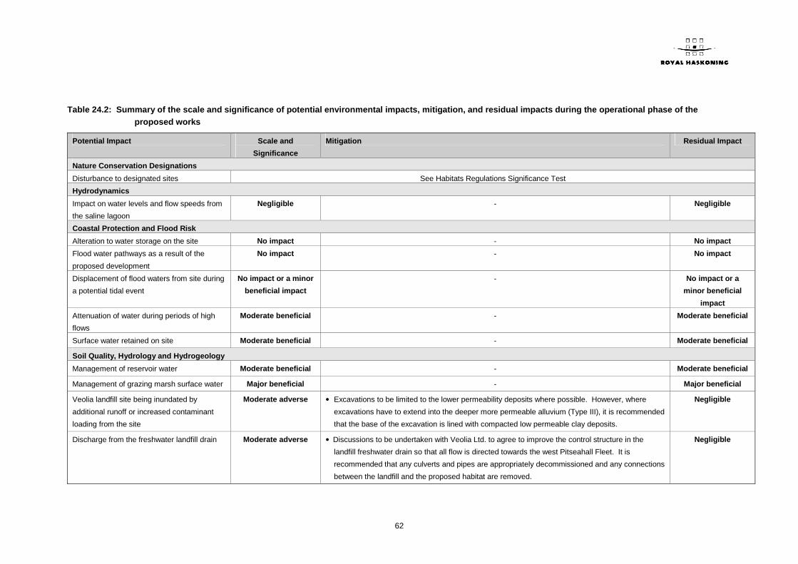
62
Table 24.2: Summary of the scale and significance of potential environmental impacts, mitigation, and residual impacts during the operational phase of the proposed works
Potential Impact Scale and
Significance
Mitigation Residual Impact
Nature Conservation Designations
Disturbance to designated sites See Habitats Regulations Significance Test
Hydrodynamics
Impact on water levels and flow speeds from
the saline lagoon
Negligible - Negligible
Coastal Protection and Flood Risk
Alteration to water storage on the site No impact - No impact
Flood water pathways as a result of the
proposed development
No impact - No impact
Displacement of flood waters from site during
a potential tidal event
No impact or a minor
beneficial impact
- No impact or a
minor beneficial
impact
Attenuation of water during periods of high
flows
Moderate beneficial - Moderate beneficial
Surface water retained on site Moderate beneficial - Moderate beneficial
Soil Quality, Hydrology and Hydrogeology
Management of reservoir water Moderate beneficial - Moderate beneficial
Management of grazing marsh surface water Major beneficial - Major beneficial
Veolia landfill site being inundated by
additional runoff or increased contaminant
loading from the site
Moderate adverse • Excavations to be limited to the lower permeability deposits where possible. However, where
excavations have to extend into the deeper more permeable alluvium (Type III), it is recommended
that the base of the excavation is lined with compacted low permeable clay deposits.
Negligible
Discharge from the freshwater landfill drain Moderate adverse • Discussions to be undertaken with Veolia Ltd. to agree to improve the control structure in the
landfill freshwater drain so that all flow is directed towards the west Pitseahall Fleet. It is
recommended that any culverts and pipes are appropriately decommissioned and any connections
between the landfill and the proposed habitat are removed.
Negligible

63
Potential Impact Scale and
Significance
Mitigation Residual Impact
Leakages and spillages of fuel and oil
resulting in pollution of the surface water and
groundwater
Minor adverse • A site EMP should be followed by contractors who work on site. Negligible
Estuarine Water Quality
Potential transport of contaminants that may
be locked in the soil of the saline lagoon site
No impact - No impact
Volumes of fresh water entering Holehaven
Creek and Benfleet Creek.
No impact - No impact
Enhanced carbon and nutrient storage
capacity and hence improved water quality in
East Haven Creek
Minor beneficial - Minor beneficial
Marine Ecology
Disturbance (scour impacts) to intertidal
habitats through the operation of the outfall
structure
No impact - No impact
Reduced exposure of a small area of
intertidal habitat (Tidal prism impacts)
Moderate adverse • Creation of the saline lagoon, to include 10 ha of intertidal BAP habitat. Colonisation of the
saline lagoon can be promoted through the translocation of saltmarsh from the affected area in
East Haven Creek into the lagoon.
Moderate to major
beneficial impact
Transportation of contaminated material No impact - No impact
Salinity regime No impact - No impact
Disturbance to commercial fisheries No impact - No impact
Terrestrial and Freshwater Ecology
Creation of wetland habitat and improved
management of the grassland
Major beneficial - Major beneficial
Loss of water vole habitat
Major adverse • Post construction monitoring will be undertaken for four years following the translocation
exercise.
• Monitoring and trapping of mink will be undertaken for four years post construction.
• A full mitigation strategy for water voles will be developed and agreed in advance with Natural
England.
Minor beneficial

64
Potential Impact Scale and
Significance
Mitigation Residual Impact
Loss of reptile habitat Moderate adverse • Compensatory reptile habitat will be provided. This will include areas suitable for basking and also
provide sufficient cover and refugia.
• Hibernacula and refugia will be created in the areas outside of the site (location to be confirmed
with Natural England) to increase the carrying capacity of those areas, which are already known
to support reptiles. Vegetation will be cleared back from newly placed refugia/hibernacula (e.g.
log/rock piles) annually.
• A full mitigation strategy for reptiles will be developed and agreed in advance with Natural
England.
Negligible
Increase in foraging habitat for bats Moderate beneficial - Moderate beneficial
Creation of additional habitats for
invertebrates
Major beneficial - Major beneficial
Disturbance to Pitsea Marsh SSSI Major adverse • The flow directed towards the proposed storage reservoir will be controllable (via sluice
mechanisms). As a part of the management regime and depending on need, the flow could be
directed to the SSSI, and water levels maintained appropriately.
No impact
Ornithology
Conversion to wetland habitats Major beneficial - Major beneficial
Loss of farmland habitat Moderate adverse • During the operational phase, the farmland within the site but outside the Reserve itself will be
managed in a way to specifically encourage species such as corn bunting and skylark to remain
on site.
• Arable fields to the north of the newly created habitat will be entered into Environmental
Stewardship, enabling the creation of conservation headlands and field margins. It will also
include the creation of skylark plots in the fields. There are also options to plant wild seed mixtures
that will encourage invertebrates and a source of seeds for overwintering farmland species.
• The management and restoration of hedgerows around the arable fields will provide habitat for
song thrush, dunnock and linnet.
Negligible
Changes to East Haven Creek hydrology and
water quality
No impact - No impact

65
Potential Impact Scale and
Significance
Mitigation Residual Impact
Visitor related disturbance to birds present on
site
Minor adverse • Creation of hides and screening along more open areas of habitat.
• The planting of native species as boundaries around the car park and along the connecting paths.
Negligible
Navigation
Changes to the navigable channel Negligible - Negligible
Archaeology
Disturbance to cultural heritage assets within
the study area
Negligible impact - Neutral
Landscape and Visual Setting
Use of the Green Belt, and habitat creation Major beneficial - Major beneficial
The character of the Diverse Coastal
Grassland area
Moderate beneficial - Moderate beneficial
Two new large water bodies will be created
within the site; a reservoir and a saline
lagoon
Major beneficial - Major beneficial
Viewpoint 1 (Long distance view east from
High Road, Fobbing)
No effect - No effect
Viewpoint 2 (Viewing point at St. Michael's
Tower, Pitsea facing south)
Major beneficial - Major beneficial
Viewpoint 3 (Long distance view from A13
facing south)
Minor beneficial - Minor beneficial
Viewpoint 4 (Medium distance view from
Church Lane facing south)
No effect - No effect
Viewpoint 5 (Short distance view from A130
above East Haven Creek facing west)
Moderate beneficial - Moderate beneficial
Viewpoint 6 (Long distance view from A130
(Canvey Road) facing west)
No effect - No effect

66
Potential Impact Scale and
Significance
Mitigation Residual Impact
Traffic and Access
Additional traffic on the surrounding highway
network
Minor adverse - Minor adverse
Pedestrian routes Major beneficial - Major beneficial
Cycle facilities Major beneficial - Major beneficial
Use of public transport Minor beneficial - Minor beneficial
Noise and Vibration
Noise and vibration impacts from large
numbers of visitor traffic
Major adverse • Involvement of the local community will reduce any concerns of the residents such that the
potential for an impact to arise is reduced to a level.
Minor adverse
Air Quality
Exhaust emissions from road traffic
generated by visitors to the proposed
scheme
Negligible - Negligible
Tourism, Recreation and Socio-Economics
Increased traffic in the vicinity Minor to moderate
adverse
• Careful and timely consultation and dialogue with local residents, businesses and the cemetery
providing a sense of involvement and control with regard to any inconvenience or nuisance.
Negligible to minor
adverse
Changes to access and general recreation Major beneficial - Major beneficial
Impacts on recreation and tourism due to the
ornithological interest of the reserve
Major beneficial - Major beneficial
Impact on tourism due to changes to the
landscape and visual setting
Moderate beneficial - Moderate beneficial
Water Framework Directive
Reduction in freshwater flow; Operation of
the saline lagoon; and Infiltration of pollutants
into groundwater bodies
See Soil Quality, Hydrology and Hydrogeology;
Estuarine Water Quality; and
Marine Ecology and Commercial Fisheries
Habitats Regulations Screening Assessment
Likely Significant Effect on the black-tailed
godwit population or the habitats that support
Unlikely to have a
significant effect
- No Likely Significant
Effect

67
Potential Impact Scale and
Significance
Mitigation Residual Impact
them (including those in Holehaven Creek);
and disturbance to the Benfleet and
Southend Marshes SPA

68
=o=o=o=