boston preparedness project 2-years later: recommendations … · slide 1 © - 2005 esri homeland...
TRANSCRIPT

Slide 1
© www.AppGeo.com - 2005
ESRI Homeland Security SummitBoston Preparedness Project 2-years Later:
Recommendations in Action
Presented by:Michael Terner
Executive Vice President, Applied Geographics, Inc.
Contributions from:Brian Hebert, AppGeoPeter Bujwid, AppGeoRich Grady, AppGeo
Michael Philbin, MEMA

Slide 2
© www.AppGeo.com - 2005
Overview of Presentation
Overview of Boston Preparedness Pilot
Observations from NCR/HSIP Pilot and involvement in Project Homeland
Issues of schema development and normalization
Observations from Massachusetts Emergency Management Agency (MEMA) eCEMP Project
Distributed, web-based critical infrastructure data collection

Slide 3
© www.AppGeo.com - 2005
The Boston Preparedness Pilot Project, Sept. 2003
Cover story of GeoIntelligence Magazine – Mar/Apr ‘04http://www.appgeo.com/clients/NOAA_HomelandSecurity
Phase I: Funded by MassGISPoll First Responders for GIS data needs
Explore data schema design issues
Phase II: Funded by NOAADevelop/assemble priority critical infrastructure (CI) data layers
Offer lessons learned to other 132 Urban Areas

Slide 4
© www.AppGeo.com - 2005
Boston Preparedness Project Data Listing
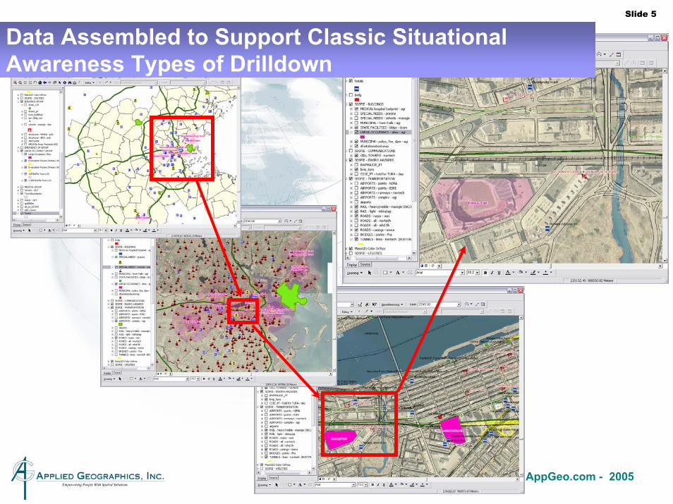
Slide 5
© www.AppGeo.com - 2005
Data Assembled to Support Classic Situational Awareness Types of Drilldown

Slide 6
© www.AppGeo.com - 2005
Boston Preparedness Pilot Project Data Quality Recommendations
Assembling the most accurate data requires local inputLocal data must rollup to national level, not vice versa
Assembling the data is only the first step, mechanisms for maintaining the data are essential
Building high-quality homeland security and critical infrastructure protection applications implies a need for laborious data quality improvement work
“…Unglamorous data development and data quality enhancement work is a necessary precursor to more sexy application development work…”
On-line, web-based markup tools can greatly facilitate the ability for widely decentralized organizations to participate in data collection and quality assurance efforts

Slide 7
© www.AppGeo.com - 2005
Boston Preparedness Pilot Project RecommendationsOn the role of the Federal Government
Recommendation that local data should “rollup” into national data sets and that the Federal role in direct data collection might be limited
Purchasing imageryEstablishing blanket agreements with commercial data providers
However, the Federal Government plays a vital role to “help orchestrate decentralized data collection efforts”
Setting standards for data format and contentAs Jack’s slide stated: “Local transactions, National Specifications”
Setting ground rules for data collection practicesFacilitating the development of the “recipe” that each Urban Area should follow

Slide 8
© www.AppGeo.com - 2005
Homeland Security Infrastructure Protection (HSIP) / National Capital Region (HSIP/NCR) Pilot Project
Worked under Michael Baker, Corp. on contract to National Geospatial-Intelligence Agency (NGA) during 2004Explored CI data schema options and complexities and piloted development for NCR
Reconcile SDSFIE with HSIPDevelop a schema for a subset of HSIP and implement in a personal Geodatabase
• HSIP “layer list” vs. structured schema
Conceptualize HSIP data warehousing scenarios and ETL proceduresDevelop tools for schema-to-schema mapping and metadata tracking from multiple sourcesPopulate target HSIP schema with actual data from NCRDocument lessons-learned and recommendations

Slide 9
© www.AppGeo.com - 2005
Project Homeland
Worked under ESRI on contract to National Geospatial-Intelligence Agency (NGA) during 2004-2005
Develop a refined Homeland Security Infrastructure Protection (HSIP) layer list, including Sectors and Features, with associated documentation
Build a schema for the refined HSIP
Implement in a personal Geodatabase with associated documentation
Iterate with stakeholders (NGA, DHS, USGS, DoD/Northcom) on application to Pilot Cities (e.g. San Francisco, Colorado Springs, Arizona Border Area)
Slide 10
© www.AppGeo.com - 2005
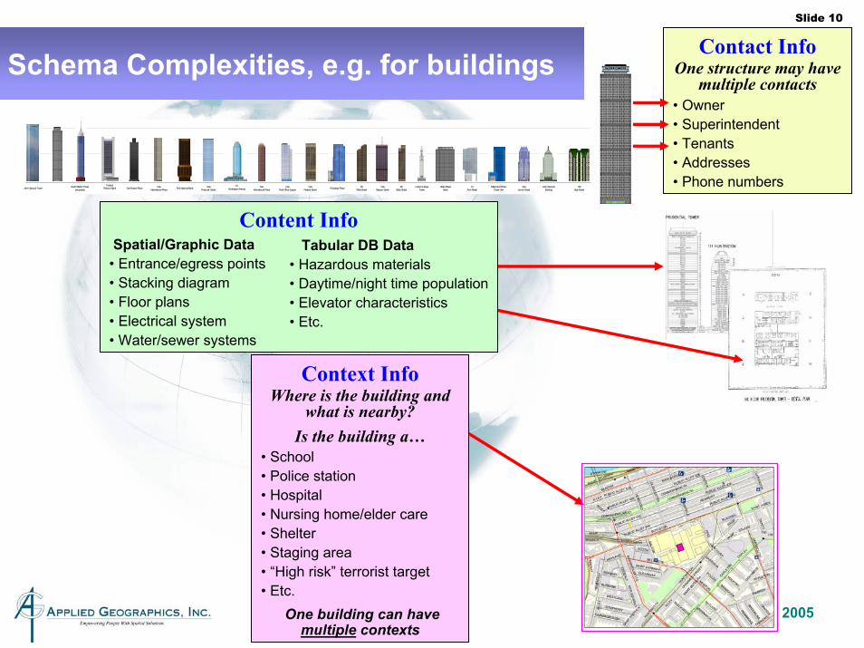
Contact InfoOne structure may have
multiple contacts• Owner• Superintendent• Tenants• Addresses• Phone numbers
Context InfoWhere is the building and
what is nearby?Is the building a…
• School• Police station• Hospital • Nursing home/elder care• Shelter• Staging area• “High risk” terrorist target• Etc.
One building can have multiple contexts
Content InfoSpatial/Graphic Data
• Entrance/egress points• Stacking diagram• Floor plans• Electrical system• Water/sewer systems
Tabular DB Data • Hazardous materials• Daytime/night time population• Elevator characteristics• Etc.
John Hancock Tower South Station Tower(proposed)
FederalReserve Bank One Boston Place One
International Place First National Bank OneFinancial Center
111Huntington Avenue
TwoInternational Place
OnePost Office Square
OneFederal Street Exchange Place 60
State StreetOne
Beacon Street28
State StreetCustom House
TowerState Street
Bank33
Arch StreetMillennium Place
Tower OneOne
Lincoln StreetJohn Hancock
Building125
High Street
Schema Complexities, e.g. for buildings

Slide 11
© www.AppGeo.com - 2005
Schema challenge: Multi-role GIS features
The same base GIS feature can really be several different things.
A school can also be a day care center, a shelter, or an emergency operations center.
A fire station and police station can occupy the same building
How can we best model this to support data import, use, and updating?

Slide 12
© www.AppGeo.com - 2005
GeoDatabase
Complex relationships, connectivity, sophisticated applications
Schema Complexity Hierarchy
Machine Processing
SDSFIE
More specific, more features, Military Base FacilitiesApplication
Sophistication HSIP
Flat, denormalized views for easy exchange and viewing
Palanterra(early versions)
Minimal structure, some metadata requiredHumanVisual
Features + Attributes + Domains + Relationships = Cost

Slide 13
© www.AppGeo.com - 2005
GIS warehouse can benefit from schema simplification
Easier to exchange and import into central repositoryThe ETL is easier (extraction; translation; loading)
Facilitates use of XML
Easier to QAQC and cleanup
Easier to use in viewing applications

Slide 14
© www.AppGeo.com - 2005
ConclusionsSchema issues are important but have yet to be resolved categorically
Project homeland is ongoingPeople continue to wait for “the next HSIP”
Simplicity aids in data warehousing challenges
Complexity aids in rich applications
Highlights importance of developing these schemasData contributors want the roadmap

Slide 15
© www.AppGeo.com - 2005
Massachusetts Emergency Management Agency (MEMA) eCEMP: Comprehensive Emergency Management Plan Web-site

Slide 16
© www.AppGeo.com - 2005
Comprehensive Emergency Management Planning in Massachusetts
351 Cities and Towns As well as Wampanoag Regional Enterprise Zone
No unincorporated places
Local Rule and strong municipal identity
Limited County Government
Largest community is Boston with 589,000
Smallest community is Gosnold with 86

Slide 17
© www.AppGeo.com - 2005
Comprehensive Emergency Management Planning in Massachusetts
Foundation for emergency management and planning is at the community level
CEM Plan identifies:HazardsVulnerable populationsResponse resourcesBasic preparation, response, recovery and mitigation steps

Slide 18
© www.AppGeo.com - 2005
CEM Plan Creation, historically
CEM Plans are created from data prepared by communities using a Data Collection Packet or DCP
Historically, an MS-Word template
Information harvested from MS-Word by MEMA feeds an MS-Access database
Multi-year update cycle (every 3-4 years)Regional MEMA office provides community assistance
Mapping, using GIS, completed by MEMA

Slide 19
© www.AppGeo.com - 2005
Drive for improvement…
Need to provide communities with a better and more timely plan update process
Need to capture CEM Plan related data in a more structured and robust manner – Oracle DB
Need to promote and support state information mining of locally collected data
Local knowledge critical to improving data quality
Slide 20
© www.AppGeo.com - 2005
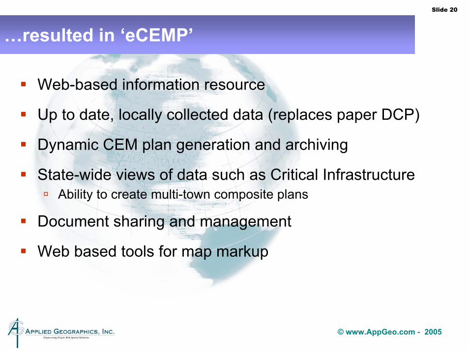
…resulted in ‘eCEMP’
Web-based information resource
Up to date, locally collected data (replaces paper DCP)
Dynamic CEM plan generation and archiving
State-wide views of data such as Critical InfrastructureAbility to create multi-town composite plans
Document sharing and management
Web based tools for map markup

Slide 21
© www.AppGeo.com - 2005
eCEMP will…
Allow MEMA to collect and build statewide datasets using the best ‘local’ knowledge including location data
Assist MEMA in allocating state resources
Give agency new analytical capabilities – vanishing political boundaries
Become hub for information pertaining to emergency management
The eCEMP Website provides an important tool for all hazard planning at the Community, Regional and State levels and will also help meet Homeland Security planning needs.

Slide 22
© www.AppGeo.com - 2005
eCEMP Architecture
The vast majority of eCEMP is an Oracle DB
Large set of forms authored in VisualStudio.NET
Mapping is supported with a thin client and ArcIMS web-services emanating from MassGIS

Slide 23
© www.AppGeo.com - 2005
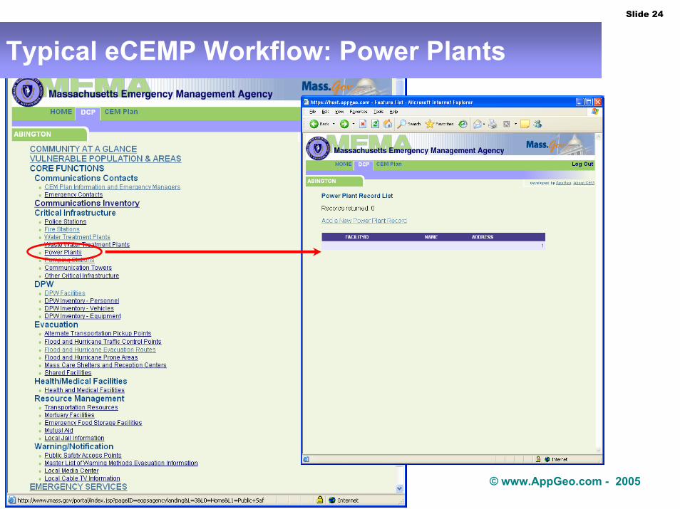
Typical eCEMP Workflow: Power Plants
Multiple levels of users
Authenticated login
User can only edit “their” community
MEMA users can review any community’s plan
Slide 24
© www.AppGeo.com - 2005
Typical eCEMP Workflow: Power Plants

Slide 25
© www.AppGeo.com - 2005
Multi-role facilities: distinction between “facility” & “features”
Faci
lity
Rec
ords
M
anag
emen
t
Feat
ure
Rec
ords
Man
agem
ent
Maintain Map Label Maintain Map Label Maintain Map Label
Maintain Feature Location
24 Bigelow St.Contact Info.
Geocode
Police Station Mass Care Shelter Fire Station

Slide 26
© www.AppGeo.com - 2005
User selects an existing facilityQueries to ID subset of facilities to narrow searchChooses an existing facility to assign as a Power Plant featureAdds additional Power Plant characteristic information
Typical eCEMP Workflow: Power Plants

Slide 27
© www.AppGeo.com - 2005
Initial facility locations derived from batch geocoding by MEMAUsers with local knowledge can refine location using MassGIS orthophotos as they create “features”
Users interactively “move the point”
All features derived from that facility will benefit from the improved location
Typical eCEMP Workflow: Power Plants

Slide 28
© www.AppGeo.com - 2005
Application Provides Interactive Digitizing of Points and Lines on top of MassGIS ArcIMS Web Services
MassGIS web map services
MEMA Oracle database
MEMA eCEMPapplication

Slide 29
© www.AppGeo.com - 2005
Application Provides Interactive Label Placement to Create Legible Final Maps

Slide 30
© www.AppGeo.com - 2005
Application Provides Printing of Reports & Attachments

Slide 31
© www.AppGeo.com - 2005
Reports, Maps & Attachments Produced as PDF

Slide 32
© www.AppGeo.com - 2005
eCEMP Current Status & Next Steps
MEMA deployed training instance of site at AppGeo254 training “sessions” logged in August64,000 page hits
Application installed on CHSB’s Oracle Server this monthCriminal History Service Board offered use of Oracle server for no-cost hostingPlanned to be operational this Fall/Winter
Version 2 under planningFunding requiredHopes that success of version 1 will help
Highlights of potential Version 2Self hosted by MEMATighter integration with GIS server environmentFeatures go directly into ArcSDE schemaRegional and state reports/maps built-outNIMS typing for featuresWebEOC linkages

Slide 33
© www.AppGeo.com - 2005
Conclusions
Geospatial applications for Homeland Security/Defense continue to evolve and gain importance
Looking at early projects and applying lessons learned is critical for continued improvements
As more advanced end-user applications, e.g. Palanterra™, continue to come on-line there will be increased demand for better quality data
And hopefully support for the hard work involved in creating high-quality and reliable local information

Slide 34
© www.AppGeo.com - 2005
Questions & Discussion