borssele wind farm zone - project and site description
TRANSCRIPT

Borssele Wind Farm ZoneProject & Site Description
>> Sustainable. Agricultural. Innovative. International.

ForewordThe Netherlands wants sustainable, reliable and available energy that is affordable for everyone. A transition to sustainable energy is of great importance. Not only because of the climate and the declining availability of fossil fuels, but also to be less dependent on international energy suppliers. In the National Energy Agreement, a goal of 16% sustainable energy in 2023 was agreed on with 40 parties. We need all the different sustainable energy sources for this, including wind energy.
In September 2014, the Dutch government designated three areas where wind farms can be developed the coming years. These areas are located off the coast of North- and South Holland and the province of Zealand near Borssele. The first area that will be developed is the Borssele zone, outside the 12-mile zone off the coast of Zealand and designated in 2009. Because Borssele is relatively near shore, the costs of development and operation of the wind farm will be relatively low. It is also an area with relatively little other interests. For example, there are no oil and gas platforms that have to be taken into account. Before development, the plans will be presented and discussed with stakeholders.
In consultation with the wind energy sector, a new system was designed for the deployment of offshore wind energy. The government is responsible for all conditions like permits and the connection to the grid. This approach contributes to efficient use of space, cost reduction and an acceleration of the deployment of offshore wind energy. Companies that want to develop a wind farm can register for one of the selected areas. The company with the best and cheapest plan obtains the permit and grant to develop the park.
This Project & Site Description provides an overview of the current progress towards the first step in the process to increase from 1,000 to 4,500 MW offshore wind power: the tendering of wind farm sites Borssele I and II, with a total capacity of 700 MW. In the months towards the tender, the Project & Site Description will be updated accordingly.

3
Table of Contents1 Objectives & Reading Guide 5
1.1 Objectives 51.2 Reading Guide 5
2 General introduction & Legal Framework 62.1 Offshore wind farms in the Netherlands 62.2 The roadmap towards 4,500 MW offshore wind power 62.3 The Offshore Wind Energy Law 62.4 Wind farm zones 92.5 The 2015 Tender: Borssele wind farm zone 10
3 Process & Quality Assurance 113.1 Process 113.2 Project Management 113.3 Procurement 123.4 Quality Assurance 13
4 Borssele Wind Farm Zone Site Description 144.1 General Description 144.2 Layout & coordinates 144.3 Exclusion Zones 174.4 Specific characteristics of the wind farm zone 184.5 Bandwidth of design characteristics 194.6 Environmental Impact Assessment Procedure 204.7 Existing infrastructure 214.8 Nearby Belgian wind farms 224.9 Applicable laws for activities in the Borssele wind farm zone 23
5 Site data 245.1 Geological Desk Study 245.2 Morphodynamical Desk Study 255.3 Archaeological assessment 275.4 Unexploded Ordnance (UXO) assessment 295.5 Metocean Study 325.6 Assessment Wind Measurement Campaign options 34

4
6. Electrical Infrastructure 366.1 General introduction 366.2 Technical Concept 366.3 Locations TenneT platforms 376.4 Voltage level for connection (66kV) 376.5 Commercial conditions 37
7 Next Steps 387.1 Project Planning 387.2 Deliverables and updates 39
8 Applicable documents 41

5
1 Objectives & Reading Guide1.1 ObjectivesThe Project & Site Description (PSD) aims at facilitating any party that has an interest in the (planned) SDE+ subsidy tender for the Borssele wind farm zone (BFWZ) in the Netherlands. This document summarizes:• The process towards the SDE+ tender and the legal framework.• A description of the site, the surroundings and a selection of constraints and (technical) requirements that
are deemed to be most relevant for development of the Borssele area.• All data collected by the Netherlands Enterprise Agency (Rijksdienst voor Ondernemend Nederland; RVO.nl)
regarding the physical environment of the Borssele area.This document is developed for information purposes only and is not intended to replace any legal or formally communicated rules, regulation or requirements.
1.2 Reading GuideThe Project & Site Description is a snapshot overview of the project progress and aims to provide all relevant information to interested parties as soon as possible. Therefore, multiple revisions of the Project & Site Description are planned.
This revision of the Project & Site Description covers the following aspects in the different chapters:1. Chapter 1 Objectives & Reading Guide (this chapter)2. Chapter 2 (General Introduction & Legal Framework) provides a general introduction in the history and the
current state of the Dutch offshore wind farms. Moreover, the process towards the large scale rollout of offshore wind is described, including the Offshore Wind Energy Law and wind farm site decisions.
3. Chapter 3 (Process & Quality Assurance) contains information on the process towards optimal site information for tender applicants.
4. Chapter 4 (BWFZ - Site Description) contains general information on the Borssele wind farm zone, the location, surroundings, its bathymetry, exclusion zones and the design bandwidths of offshore wind turbines allowed in the wind farm zone
5. Chapter 5 (Site Data) is a summary of all the studies that have currently been performed on the Borssele wind farm zone, and addresses the following aspects: • Soil characteristics based on geological desk study • Morphodynamical desk study • Archaeological assessment; • UXO characteristics based on UXO desk study • Metocean characteristics, based on the metocean desk study • Assessment Wind Measurement Campain options
6. Chapter 6 (Electrical Infrastructure) shows the planned location and characteristics of TenneT offshore High Voltage platforms
7. Chapter 7 (Next Steps) is an overview of the process towards the tendering of Borssele wind farm sites I and II in 2015 and the expected updates to the site data to be included in the next revisions of the Project & Site Description
8. Chapter 8 contains a list of Applicable Documents

6
2 General introduction & Legal Framework
2.1 Offshore wind farms in the NetherlandsThe existing offshore wind farms and those under construction in the Netherlands have a capacity approximately 1,000 MW. The first two wind farms built in the North Sea off the coast of the Netherlands are the offshore Wind Farm Egmond aan Zee (OWEZ, 2006) and the Princess Amalia Wind Farm (2008). The Egmond aan Zee Offshore Wind Farm lies 10-18 km off the coast and exists of 36 Vestas 3 MW turbines, is owned by Noordzeewind, a joint venture between utility company NUON and oil company Shell. Utility company Eneco owns the Princess Amalia Wind Farm, located outside the 12-mile zone, 23 km off the coast. It exists of 60 Vestas 2 MW turbines.
Two projects are currently (2014) under construction: Wind farm Luchterduinen and the Gemini wind farm. Wind farm Luchterduinen is owned by Eneco and Mitsubishi Corporation and exists of 43 Vestas 3 MW turbines located 23 km off the coast. It is expected that this wind farm will be fully operational in 2015. The Gemini wind farm will be constructed with 150 Siemens 4 MW turbines on the twin locations Buitengaats and Zee-Energie, 85 km off the coast. Gemini is owned by Northland Power, Siemens, Van Oord and HVC. This wind farm is expected to be fully operational in 2017.
2.2 The roadmap towards 4,500 MW offshore wind powerIn 2013 more than forty organisations laid the basis for a robust, future-proof energy and climate policy for the Netherlands in the Energy Agreement for Sustainable Growth (Energieakkoord voor Duurzame Groei) [1]. An important part of this agreement is scaling up offshore wind power. In September 2014 the Minister of Economic Affairs presented a road map to the parliament [2] enabling the Government to achieve this expansion of offshore wind in accordance with the time line agreed upon in the Energy Agreement.
The road map foresees an annual tendering of 700 MW in the period 2015 – 2019, with the requirement that the cost of offshore wind power will decrease by 40% in the coming years. Wind farms will become operational within four years after a decision on funding and can use the state-of-the-art technology available at that time. The legal bases of this road map will be a new Offshore Wind Energy Law.
2.3 The Offshore Wind Energy LawAs mentioned before, the Dutch government requires a cost reduction of 40% when providing future offshore wind grants. As part of this strategy, they developed a systematic framework in which the Dutch government creates designated offshore wind areas with different sites that are tendered. These sites already have a permit, an exploitation subsidy and a grid connection to the main land. Moreover, most geological and meteorological surveys have already been performed. This procedure is expected to be much cheaper than the previously tendered wind farms, in which developers were required to apply for a permit for a certain part of the North Sea and perform desk studies and surveys themselves. Finally, when large amounts of costs already were incurred, they could apply for a subsidy.

7
This new approach is presented in the Offshore Wind Energy Law (Wet Windenergie op Zee), which is expected to enter into force at the 1st of July 2015. The bill was sent to the parliament on October 17th 2014. The new system for offshore wind energy introduced with this law was designed in consultation with the sector. It contributes to a higher efficiency in the use of space, cost reduction and it accelerates the deployment of offshore wind energy. The system consists of five distinct aspects, as described in the paragraphs below.
2.3.1 Wind farms are only allowed in designated wind farm zonesUnder the National Water Plan [3], wind farm zones have been designated as shown in Figure 1. Only on sites within these zones, the construction of wind farms will be allowed. Any location outside these wind farm zones will not be consented.
Figure 1 Designated wind farm zones in the Netherlands continental shelf: A: IJmuiden Ver, B: Borssele (off the Zealand coast), C: Off the Holland Coast, D: North of the Dutch Wadden Isles. Current wind farms are shown in red/brown.

8
2.3.2 Wind farm sites consented by government (‘Kavelbesluiten’)In these wind farm zones the government decides on sites where wind farms can be constructed. Each zone can contain several sites. The Ministries of Economic Affairs and of Infrastructure and the Environment will decide on the so-called wind farm site decisions (‘kavelbesluiten’). A wind farm site decision is the necessary consent required to build a wind farm and specifies the location for the wind farm and the conditions under which it may be constructed and operated. These conditions will provide flexibility for the design of the wind farm. This gives commercial parties the best opportunities for choosing the best technical option within the natural and environmental framework and realise their project at the lowest possible costs. Wind farm site decisions are subject to an environmental impact assessment (EIA), which will be commissioned by the Ministries of Economic Affairs and of Infrastructure and the Environment.
2.3.3 Government provides site dataThe Government investigates the physical environment of the wind farm site: the soil- wind- and water conditions. This site data will be made public and provides commercial parties information for their FEED studies and to make competitive bids in the tendering procedure for the grant possibilities. The Netherlands Enterprise Agency (RVO.nl) will make the site data available. This site data includes:• Geological, morphodynamical and geomorphological data• Archaeological and UXO analysis• Metocean data• Wind resource assessment• Geophysical and geotechnical data (based on surveys)• Wind data (for Borssele based on in situ floating LiDAR campaign)
2.3.4 TSO TenneT realises grid connectionTo create economies of scale the national electricity Transmission System Operator TenneT will construct five standardised platforms with a capacity of 700 MW each in the wind farm zones. They will each be connected to the national grid with two 220kV export cables. As soon as a 380kV subsea cable is available, this will be used to reduce the amount of required cables. Connecting wind turbines directly to the TenneT platform implies no need for an OWF platform investment.
2.3.5 Grant tenderingGrants for the wind farm sites will be awarded through a dedicated call for tender under the Stimulation of Sustainable Energy Production (SDE+, Stimulering Duurzame Energieproductie). Under this scheme, producers receive financial compensation for the electricity they generate for a fixed number of years. The lowest bidder will be awarded. The bid must be equal or lower than the maximum amount (in €/kWh) set for the specific wind farm site. The lowest bidder will be rewarded with both the grant and the consent to build and operate a wind farm according to the wind farm site decisions.

9
2.4 Wind farm zonesThe Government has decided that three offshore wind farm zones will be used for the deployment of the 3,500 MW new offshore wind power as agreed upon in the Energy Agreement: Borssele (1,400 MW), South Holland coast wind farm zone (1,400 MW) and North Holland coast wind farm zone (700 MW). Figure 2 shows a schematic representation of the deployment.
Wind farms 700 MW
Wind farms in operation or under construction
Designated areas
Proposed areas
Figure 2 Tender planning for the Dutch Offshore Wind Rollout

10
The tenders to select parties for realising the offshore wind farms will be done according to the schedule below.
2.5 The 2015 Tender: Borssele wind farm zoneIn 2015 and 2016, the Borssele wind farm zone will be tendered under the Dutch Offshore Wind Energy Law. This Project & Site Description provides information on the project, the process and site data for the first tender which is planned to open in December 2015 and comprises two wind farm sites with a total capacity of 700 MW.
Year Power Wind farm zone
2015 700 MW Borssele wind farm zone
2016 700 MW Borssele wind farm zone
2017 700 MW South Holland coast wind farm zone
2018 700 MW South Holland coast wind farm zone
2019 700 MW North Holland coast wind farm zone

11
3 Process & Quality Assurance3.1 ProcessThe Dutch Ministries of Economic Affairs and of Infrastructure and the Environment are responsible for the execution of the Offshore Wind Energy Law. One of the key aspects is the preparation of a wind farm site decision (‘Kavelbesluit’ in Dutch) for the tendered locations, in this case the Borssele wind farm zone (BWFZ). The Netherlands Enterprise Agency (RVO.nl) is responsible for collecting all relevant site information that potential bidders require for preparing their bid when competing in the SDE+ tenders for the BWFZ.
The site information package should be of sufficient detail and quality. For this, RVO.nl has sought guidance and information by consulting different sources. The organisation in Denmark responsible for organising the Danish offshore wind tenders (Energinet.DK) has shared their lessons learned and shown RVO.nl how these projects are managed in Denmark. Further, RVO.nl, the Ministry of Economic Affairs, Rijkswaterstaat (part of the Ministry of Infrastructure and the Environment) and TenneT organised several workshops on various subjects with market parties, who were broadly invited by the Dutch Wind Energy Association (NWEA) and other communication channels.
RVO.nl has selected BLIX Consultancy as the primary consultant assisting RVO.nl in managing the process. BLIX is one of the leading offshore wind consultants in the Netherlands and is specialised in project management of large (offshore) wind energy projects. The consultants of BLIX have been involved in several offshore wind farm projects in the Netherlands, Germany and Belgium and were, amongst others, responsible for managing and contracting site studies and investigations for these projects.
3.2 Project ManagementThe first step in the process was the creation of the Work Breakdown Structure (WBS) and a planning for the project. On the basis of the WBS and the planning, the interfaces with other work streams in the project were managed. The WBS of the project mainly consisted of three blocks:1. Desk studies2. Site selection / prioritisation3. Detailed site investigations
These activities are interrelated with the other work streams being;1. Defining the legal framework for Offshore Wind Energy projects by the Ministries of Economic Affairs and
of Infrastructure and the Environment,2. The spatial planning and sea use as managed by the Ministry of Infrastructure and the Environment and,3. The realisation of the offshore grid under the responsibility of TenneT.
Through weekly project meetings between the parties involved these processes were aligned and information was exchanged. The overall planning and the WBS were shared with market parties in a meeting organised by RVO.nl and NWEA in order to identify possible omissions and to obtain input on objectives and content of the site studies and investigations that were put on the market.
12
3.3 Procurement3.3.1 Limited tendersThe procurement of the different studies was carried out in compliance with the applicable procurement procedures within RVO.nl. The desks studies have been procured through a limited tender where, for each study, at least two expert parties were invited to submit their proposal. The proposals have been selected on the basis of determining the economic most advantageous offer. This means that the proposals have been assessed and scored (by at least three assessors) on several aspects such as: track record, quality of the proposal and the price offered.
Studies that have been procured through a limited tender are the following:1. Geological desk study2. UXO assessment3. Archaeological assessment4. Morphodynamical desk study5. Metocean desk study
3.3.2 Public tendersThe site investigations which exceeded the expected budget for a limited tender were procured through a public European tender. These investigations included the investigations that are actually carried out offshore:1. Geophysical soil investigations2. Geotechnical soil investigations3. Wind Measurements
The offshore site investigations that need to be carried out have not yet started since the procurement process is still in progress. It is expected that these investigations will start in the first quarter of 2015.

13
3.4 Quality AssuranceRVO.nl and BLIX maintained a rigorous quality assurance procedure to provide accurate and usable studies. First, the scope of the different studies was determined using the following steps:1. RVO.nl and BLIX determined the preliminary scope of the different studies;2. Where applicable, input was provided on these scope descriptions by internal experts of other
governmental departments, agencies or external experts;3. At market consultation sessions, the scope descriptions were discussed with market parties and input on
completeness was provided by the attendees of these workshops.
In the case of studies where the results will become part of the design basis of the developer, the certifying authority DNV-GL was contracted to confirm the completeness of the scope.After the tender, during the execution of the work by the specific executor, quality assurance was performed as follows:1. The project team and experts of other ministries reviewed several drafts of the report, provided feedback
and assured that the execution of the scope was in compliance with the scope description;2. The draft report was reviewed by the independent internal and external experts;3. The certifying authority (DNV-GL) reviewed the report and provided a statement of compliance (Metocean,
Morphodynamics) to assure the results were acquired in compliance with the DNV-OSJ101 and other applicable industry standards. These statements of compliance are added to the report if applicable.
Internal experts that have provided input in the process include:1. The Cultural Heritage Agency (Archaeological desk study)2. The Ministry of Infrastructure and the Environment (Morphodynamical desk study)
External experts that have provided input in the process include:1. Windsupport Ltd (Geotechnical site investigations)2. Reynolds International Ltd (Geophysical site investigations)

14
4 Borssele Wind Farm Zone Site Description
4.1 General DescriptionThe Borssele wind farm zone (BWFZ) is located at the southern border of the Netherlands Exclusive Economic Zone (EEZ); 0.5 km from the Belgium EEZ. The zone borders on a sand extraction area in the southeast and a piloting area in the east. Anchoring areas and a shipping lane are located at the north side of the zone. The Belgian dedicated offshore wind zone is located directly to the southwest. Figure 3 shows the location of the Borssele wind farm zone, the Belgian Zone and the location of cables and pipelines.
4.2 Layout & coordinatesThe wind farm zone of approximately 344 km2 is sub-divided into four wind farm sites. In total, 1,400 MW offshore wind is planned in the zone, roughly 350 MW per site. Figure 4 and Figure 5 show the general coordinates of the Borssele wind farm zone and its different sites. In the attached memo [5] all coordinates of different sites and investigation zones of the wind farm zone are shown. Site I and II (total capacity 700 MW) are expected to be tendered by the end of 2015; Wind Farm Site III & IV will follow in 2016.
Figure 3 The Borssele wind farm zone and surrounding areas

15
Site II
Site I
Site III
Site IV
Sou
rces:
Cop
yright
© 2
014.
Ser
vice
fo
r th
e K
adas
ter
and
the p
ublic
regis
ters
, A
peld
oorn
Copyr
ight
Die
nst
Landel
ijk
Geb
ied 2012.
No
rights
can
be d
eriv
ed fro
m t
his
map
Consultant: date: 2014-07-22revisie: 2014-12-11 mapnr: 20141211RH
Borssele Wind Farm ZoneSite - zone
Legend
Wind Farm Belgium Status(situation 2014)
Designated Wind Farm ZoneNautical 12 mile
A4 - scale1:150.000
0 1 2 3km
0 1 20,5 NM
Exclusive Economic Zoneof the Netherlands
Designated Wind Farm Zone + 500m
Location helicopter approach routes not yet includedThis geographical information is based on the data available on October 28th 2014. Updates will be made available on www.rvo.nl
Overlap piloting zoneincl 500m safety zone
TenneT platform Alpha
Territorial sea
Cables safety zone 750m
Pipelines safety zone 500m
TenneT Cable Safety Zone 500m
TenneT export cables
Application
Licensed
In operation
12 N
autic
al m
ile zon
e
Figure 4 The 4 sites within the Borssle wind farm zone including the location of the TenneT platform Alpha

16
Geographical coordinates (ETRS89)
UTM (ETRS89, zone 31)
Point Nr Degrees N Degrees E Easting Northing
1 51,60230 3,10233 507087,05 5716811,66
2 51,57027 3,05828 504039,56 5713246,09
3 51,62197 2,97263 498105,40 5718993,72
4 51,74303 2,77085 484178,55 5732482,80
5 51,80073 3,06343 504373,70 5738878,38
6 51,74985 3,12080 508338,99 5733222,40
7 51,70735 3,13312 509197,84 5728498,93
8 51,69642 3,12985 508974,49 5727282,45
202 51,73228 3,14055 509706,86 5731271,30
Site II is an undivided parcel of around 68 km². Site I of around 63 km² is subdivided into 4 parcels as a result of pipelines and cables in the areas. All square kilometres mentioned in this paragraph are exclusive of safety zones, export cables, TenneT platform and potential helicopter flight paths.
Figure 5 The 4 sites of the Borssele wind farm zone and their coordinates.

17
4.3 Exclusion ZonesThe Dutch-Belgian border is located immediately south of the BWFZ; the Belgian dedicated offshore wind zone is situated on the direct opposite of this border. Paragraph 4.8 provides an overview of the Belgian Wind Farms and their characteristics. To the east, the BWFZ is bordered by the 12-mile zone and the pilotage zone ‘Steenbank’ (the blue area in Figure 4). Moreover, several pipelines and telecommunication cables are located within the zone, as shown in paragraph 4.7. These pipelines and cables, together with their safety zones (500 metres for pipelines and 750 metres for cables), are excluded from the different parcels. The part of the wind farm zone, which overlaps with the pilotage zone and an additional safety zone of 500 metres is excluded for wind farms as well. A detailed overview of the safety zones around cables and pipelines can be found in the Integrated North Sea Management Plan 2015 [6]. Table 1 provides an overview of the preliminary safety zones to be respected around wind farms:
Table 1 Required safety zones around wind farms
Please note that the distances to respect are preliminary. In some cases, i.e. the distance to shipping lanes, it is not clear yet if this should be measured from the tower or from the tower plus rotor blade.In most cases the proximity agreement between de cable or pipeline owner and the wind farm operator foresees in switching off the wind turbines closest to the cable or pipeline during repair activities.
Function Explanatory Single width safety zone
High voltage cables and pipelines
Contain high levels of metal, hence relatively easy to detect. Damages and related repairs exceptional.
500 m
Telecom cables Relatively small, hence hard to detect and vulnerable for damages, repairs are likely to occur. Repair vessels need extra space for maneuverer.
750 m
Helicopter flight paths
Apart from avoiding collisions, helicopters are affected by the wind turbine wakes.
Dependent on rotor diameter.
Sand extraction areas
Lowers the seabed, which could affect the sand coverage of cables or scour protection around foundations.
500 m
Shipping lanes Intention is to allow marine traffic up to 24 meters of the wind farm zone. Decision Q4 2014 in National Water Plan 2.
500 m

18
4.4 Specific characteristics of the wind farm zoneThe Borssele wind farm zone has the following general characteristics, as show in Table 2.
Table 2 Characteristics of the Borssele wind farm zone
Water depth ≈16 to ≈38 m
Distance from shore From 22.2 km (12 nautical miles )
Surface area (incl. safety zones) 344 km2
Surface area (excl. safety zones) 234 km2
Surface of Wind Farm Site I 44 km2 (plots of 24, 16, 1 and 3km2)
Wind Turbine Density site I 8 MW/km2
Surface of Wind Farm Site II 68 km2
Wind Turbine Density site II 5,2 MW/km2
The basic bathymetry of the BWFZ is shown in Figure 6. More detailed bathymetry and morphodynamical information of the zone are provided in the next chapters.
Figure 6 Bathymetry of the Borssele wind farm zone in 2010

19
4.5 Bandwidth of design characteristicsAs indicated before, both the permitting and EIA-procedures have already started. By allocating plots with different possibilities for wind turbine arrangements and -types and methods for foundations, within a certain range, a flexible arrangement of the plots is possible. The developer has the freedom to make an optimal design for the wind farm in terms of costs and energy yield. By assuming a worst-case scenario with regard to the possible impacts, all the different configurations that are possible in the plots are investigated in the EIA. Table 3 shows the bandwidth for different design parameters that have been chosen in the draft Memorandum Scope and Level of Detail, currently under investigation in the EIA.
Table 3 Bandwidth of design characteristics for the Borssele wind farm
If environmental requirements cannot be fulfilled, a limit of the design options on the plots will be put in place; the bandwidth in the table will be (slightly) reduced in the final wind farm site decision where appropriate. Therefore the bandwidth presented here is not final. Developers interested in the Borssele tender should keep their designs within the abovementioned characteristics in order to stay within bandwidth of the wind farm site decisions.
Subject Bandwidth
Power individual wind turbines 3 – 10 MW
Tip height individual wind turbines 125 – 250 meter
Tip lowness individual wind turbines 25 – 30 meter
Rotor diameter individual wind turbines 100 – 220 meter
Spacing between wind turbines ≥ 4x rotor diameter
Number of blades per wind turbine 2 – 3
Type of substructures Monopile, jacket, tripile, tripod, gravity based structure
Type of foundations (Mono)piles, suction buckets, gravity based structures
Installing piles Vibratory, hammering, boring, suction
In the case of hammering: hammer energy related to turbine type / pile
1,000 – 3,000 kJ, depending on soil conditions and diameter foundation
In the case of hammering: diameter pile(s) and number of piles per turbine:
Jacket 4 piles of 1,5 – 3,5 meter
Monopile 1 pile of 4 -10 meter
Tripod 3 piles of 2 - 4 meter
In the case of a foundation without hammering: dimensions at seabed:
Gravity Based ≤ 40 x 40 meter
Suction Bucket Diameter bucket: t.b.d.
Electrical infrastructure, voltage level infield cables 33kV or 66kV

20
4.6 Environmental Impact Assessment ProcedureThe procedure for an Environmental Impact Assessment (EIA) is prescribed in national and European legislation in case of activities with potentially significant environmental effects. The Environmental Impact Assessment examines the first two sites that will be tendered in 2015 and 2016. The EIA discusses the environmental impacts associated with the establishment of wind farms on these sites. The impacts are compared with the applicable environmental requirements, whereby it is assessed if they meet these requirements. The level of detail of the EIA will be in such a way that prior to the construction of the two wind farms on the basis of the site decisions, an extra EIA is not necessary.
The EIA has been prepared and is currently available for comments. Moreover, the Netherlands’ Commission for environmental assessment has already positively reviewed the draft EIA. Based on the comments from the market and environmental organisations, the EIA will be finalised.

21
4.7 Existing infrastructureSeveral operational cables and pipelines cross the wind farm zone. Furthermore, several abandoned cables/pipelines run through the Borssele area. Figure 7 shows the Borssele wind farm zone and infrastructure crossing the zone.
Currently, talks between RVO.nl and the operators of cables concerning possibilities for relocation of cables, crossing- and or proximity arrangements are underway.
Name Type Status
TAT14 Telecommunications Exclusion Zone
Franpipe Natural Gas-pipeline Exclusion Zone
SeaMeWe 3 Telecommunications Feasibility of relocating cable
Farland North Telecommunications Exclusion Zone
Zeepipe Natural Gas-pipeline Exclusion Zone
Figure 7 Cables and pipelines in the Borssele wind farm zone

22
Name Hub-height [m]
Rotor diameter [m]
Assumed individual capacity [MW]
Nr Total capacity [MW]
Status
Belwind I 76 90 3 55 165 Fully commissioned
Belwind II 165 Under development
BW-Pilot 100 150 6 1 6 Under construction
Northwind 84 112 3 72 216 Fully commissioned
C-Power I 94 126 5 6 30 Fully commissioned
C-Power II 94 126 6,15 30 180 Fully commissioned
C-Power III 94 126 6,15 18 110,7 Fully commissioned
Rentel 6 288 Consent received
Seastar 6 246 Consent received
Norther 6 350 Consent received
Mermaid 6 266 Consent received
Northwester 2 224 Consent received
4.8 Nearby Belgian wind farms
Northwester 2
Mermaid
Belwind
Seastar
Northwind
Rentel
Norther
C-Power
Figure 8 The location of the Belgian Offshore Wind Farms directly southward of the BWFZ
Several Belgian wind farms are operational or under construction directly south of the Dutch-Belgian Border. Figure 8 shows a map of the Belgian dedicated offshore wind zone, the different wind farms in the zone and their status and characteristics.

23
4.9 Applicable laws for activities in the Borssele wind farm zoneIn the Exclusive Economic Zone (EEZ) outside the Dutch territorial sea (the 12-mile zone), only the laws declared in force for that zone by the legislator are applicable. These include the Water Act, the Mining Act and the Earth Removal Act. The Flora and Fauna Act and the Nature Conservation Act will eventually also enter into force within the EEZ.

24
5 Site data5.1 Geological Desk Study5.1.1 IntroductionThe Geological Desk Study provides insight into the soil conditions at the Borssele wind farm zone, more specifically:• Insight in the geological stratification of the Borssele wind farm zone on the basis of sufficient and relevant
cross sections of the site.• Information on the uniformity of the geological stratification and the presence of possible disturbances in
the uniformity of layers as a result of e.g. ancient streambeds, boulders, etc.• Description of the soil characteristics of the geological layers and possible disturbances.• Description of the possible impact (design & installation) of the different geological layers on generic wind
turbine foundation concepts.
5.1.2 SupplierA consortium of CRUX, ediGEO and GisSense performed the geological desk study [7]. CRUX has experience in soil research for both onshore as well as offshore projects, providing soil stability analysis during the lifting of the Costa Concordia and geotechnical research on the consequences of gas production in Groningen.
5.1.3 ResultsBecause of limited commercial interest in the area, both geological and geotechnical data in the Borssele area are scarce. For example, only few borings with a depth of 1-5 meters are available and none are available with a longer depth.The water depth of the zone ranges from 10 to 40 meters, with dispersed sand banks of up to 20 meters high. The subsurface consists of Pleistocene (sand) and Holocene (sand, clay, peat) formations in the upper 10 to 30 meters, on top of stiff clay Tertiary deposits, as shown in Figure 9.
Figure 9 Top of Tertiary (left) and Pleistocene (right)

25
5.1.4 ConclusionFrom a geological perspective, the soil conditions of Borssele are suitable for offshore wind developments using all common installation techniques and foundation types. However, based upon data currently available, it is impossible to identify areas with more optimal or less optimal soil conditions within the site.
5.2 Morphodynamical Desk Study5.2.1 IntroductionThis study provides insight in the sea bed dynamics at the Borssele wind farm zone and consists of the following elements:1. Improve the understanding of the seabed morphology at the Borssele wind farm zone.2. Improve the understanding of the seabed morphodynamics at the Borssele wind farm zone over the
lifetime of a wind farm (25 years).3. Define design reference seabed levels at the Borssele wind farm zone over the lifetime of a wind farm
(25 years).4. Input for soil investigations still to be carried out.
5.2.2 SupplierDeltares has performed the morphodynamical desk study [8]. The institute has an extensive track record in offshore wind, with most studies related to topics such as scour prediction and protection, metocean conditions, wave loads, cable burial depth and morphodynamics. Deltares has previously performed similar studies for other offshore wind farms, such as Princess Amalia wind park, Butendiek, Luchterduinen Nordergründe and Belwind. The Belwind site is adjacent to the Borssele site, on the Belgian side of the border. Therefore, Deltares also has in depth knowledge of the morphology of this specific part of the North Sea. DNV-GL has been contracted to assess the methodology and the results of the study. This process has taken place with a positive outcome and will be confirmed by a statement of compliance which is expected soon.
5.2.3 ResultsHigh quality bathymetry data from 2010 were compared with combined data of around 2000 in order to gain insight into the soil morphology of the system. The site has highly dynamic soil morphology, consisting of static, shore-parallel sand banks overlaid with dynamic shore-perpendicular sand waves. Within the area, opposing migration directions were found, as shown in Figure 10.

26
The shore perpendicular sand waves have a typical average length of 230 meters, height of 4 meters and migration speeds are in the order of -1.7m/yr. (NE-direction) to 3.2m/yr. (governing SW-direction).From the data, the reference seabed level (RSBL) was determined, indicating the predicted lowest seabed level during the lifetime of the wind farms in the Borssele area. Comparison of the RSBL with the most recent bathymetry from 2010 showed a predicted maximum seabed level lowering of approximately 8 meters.
5.2.4 ConclusionBorssele wind farm zone (BWFZ) has a highly dynamic soil morphology that can lead to a maximum seabed lowering of approximately 8 meters. This lowering should be taken into account when designing the offshore constructions.In the second phase of this study, all findings will be updated and validated using an up to date (still to be performed), high-resolution bathymetrical dataset. The findings will be complemented with GIS-files with different ‘recommendation zones’ for foundations and electricity cables.
Figure 10 Morphodynamics: Sand dune movement in the Borssele wind farm zone

27
5.3 Archaeological assessment5.3.1 IntroductionThe purpose of the study is insight in archaeological aspects that can play a role in the development of the wind farm zone Borssele. The main objectives of the study are:1. Assess whether there are (indications for) areas with specific archaeological interest (wrecks and prehistoric
life) at the Borssele wind farm zone.2. If present, define expected location, size and dating of the areas with specific archaeological interest.3. Determine the possible effect of the installation of offshore wind farms on the areas with specific
archaeological interest.4. Assess possibilities to mitigate the disturbance of areas with specific archaeological interest as a result of
installing offshore wind farms.5. Identify whether any further investigations should be carried out from archaeological point of view and
make a recommendation on the scope and specifications of these investigations.6. Define requirements for any activity carried out in the wind farm zone (investigations or monitoring
activities, installation activities, operational activities) that could have an effect on archaeological aspects in the wind farm zone.
5.3.2 SupplierVestigia Coastal & River Archaeology has been selected to perform the Archaeological desk study [9]. This subsidiary of Vestigia BV combines the offshore archaeology expertise of Vestigia and cooperating partners. Cotswold Archaeology, one of the largest suppliers of maritime archaeological expertise in the UK, ADC Maritiem and several freelance experts in the Netherlands and abroad are among the partners. Vestigia has a track record in maritime archaeological preparatory research for offshore wind and other offshore activities. For example, they provided research for NUON’s offshore wind prospects, the Maasvlakte 2 and the COBRA-cable between the Netherlands and Denmark.
5.3.2 ResultsThe report assesses both the presence of early prehistoric sites from an era when the North Sea was still land, as well as historic shipwrecks, lost cargo and crashed airplanes.
Prehistoric sites:1. No early prehistoric sites have been identified within the wind farm itself, the nearest being 9 miles
southeast of the wind farm zone.2. If present at all, prehistoric remains are located at a depth of about 30 to 40 meters below present day sea
level. This means that the site has been submerged by the expanding North Sea around 7000 BCE and therefore possible settlements will most likely be older. However, population density in North-western Europe during these early stages of prehistory was very low. Therefore, the density of archaeological traces of those people is also very low and the chance that the traces are well preserved even lower. Conclusion, the chances of encountering prehistoric archaeology within the wind farm zone are small (low sensitivity).
28
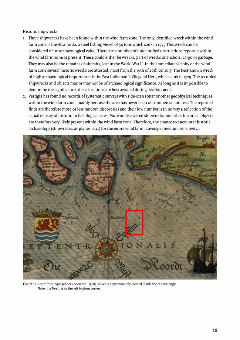
Historic shipwrecks:1. Three shipwrecks have been found within the wind farm zone. The only identified wreck within the wind
farm zone is the Alca Torda, a steel fishing vessel of 54 tons which sank in 1973.This wreck can be considered of no archaeological value. There are a number of unidentified obstructions reported within the wind farm zone at present. These could either be wrecks, part of wrecks or anchors, cargo or garbage. They may also be the remains of aircrafts, lost in the World War II. In the immediate vicinity of the wind farm zone several historic wrecks are attested, most from the 19th of 20th century. The best-known wreck, of high archaeological importance, is the East Indiaman ‘t Vliegend Hert, which sunk in 1729. The recorded shipwrecks and objects may or may not be of archaeological significance. As long as it is impossible to determine the significance, these locations are best avoided during development.
2. Vestigia has found no records of systematic surveys with side-scan sonar or other geophysical techniques within the wind farm zone, mainly because the area has never been of commercial interest. The reported finds are therefore more or less random discoveries and their low number is in no way a reflection of the actual density of historic archaeological sites. More undiscovered shipwrecks and other historical objects are therefore very likely present within the wind farm zone. Therefore, the chance to encounter historic archaeology (shipwrecks, airplanes, etc.) for the entire wind farm is average (medium sensitivity).
Figure 11 Chart from ‘Spiegel der Zeevaerdt’ (1588). BFWZ is approximately located inside the red rectangle. Note: the North is in the left bottom corner

29
5.3.4 Conclusions and recommendationsNo early prehistoric sites have been identified within the wind farm itself and the chance to encounter prehistoric archaeology within the wind farm zone is small. Therefore, further archaeological survey with the intention to establish prehistoric sites is not recommended.
Historic shipwrecks have been identified in the area and shipwrecks of high archaeological significance have been found in the vicinity, leading to an average chance to encounter historic archaeology. It is recommended to perform a geophysical area survey (side scan sonar or multi beam, for example simultaneously with UXO surveys). Based on the recommendations of Vestigia, RVO.nl has determined to start a geophysical survey in Q1 of 2015. Upon discovery of an archaeological site, its historic and scientific value has to be assessed. In case of archaeological significance, one can either avoid the site or salvage the remains, the latter incurring high costs.
5.4 Unexploded Ordnance (UXO) assessment5.4.1 IntroductionThe UXO desk study gives insight in the areas in the Borssele wind farm zone with an increased risk of encountering unexploded ordnances (UXO’s).The main objectives of this study are:1. Identify constraints for offshore wind farm related activities in the Borssele wind farm zone as a result of
the presence of UXO’s.2. Identify areas within the Borssele wind farm zone that should preferably not be used for the installation of
offshore wind farms and/or cables.3. Identify requirements from UXO perspective that should be taken into account for: a. Determining the different concession zones in the wind farm zone. b. Carrying out safe geophysical & geotechnical investigations. c. Safe installation of wind turbine foundations. d. Safe installation of cables.
5.4.2 SupplierREASEuro has performed the UXO Desk study [10]. The company has experience in offshore UXO studies; most notably serving dredging, wreck recovery and offshore wind construction. Since 2012, REASEuro has been involved with several offshore projects in the Persian Gulf performing data analysis, project risk assessment and coordination of demining activities. The project team members for this assessment have specific ‘North Sea-experience’ from their previous employment at Van Oord Dredging and the demining department of the Royal Dutch Navy.

30
5.4.3 ResultsThe wind farm zone Borssele and its surrounding areas were the scene of many war related activities in World War I and World War II. In both world wars a large number of naval mines were deployed in the North Sea, which where only partially recovered after the war. Moreover, the wind farm zone Borssele is located in the main flight path of Allied bomber raids. As a consequence a large number of aircrafts have crashed in the North Sea and many bombs were dropped in the North Sea (see Figure 12).
Finally, after the war, ordnances could have been moved as a result of fishing, tidal streams and seabed migration. Due to the previous facts the entire wind farm zone Borssele is to be considered a UXO risk area. This result is validated by the fact that since 2005 fishermen have found over 20 UXO’s.
The UXO can be sensitive to hard jolts, change in water pressure and acceleration with an amplitude >1m/s2. A detonation can lead to serious damage to equipment and injuries to crewmembers. The possible presence of UXO in the area, however, is no constraint for offshore wind farm related activities. With proper UXO Risk Management the risks can be reduced to a level that is as low as is reasonably practicable (ALARP).
A main challenge in UXO Risk Management at Borssele wind farm zone is de abovementioned movement of the UXO over the sea bottom. This can lead to resurfacing UXO’s that were buried during preliminary scanning and introduction of new UXO’s by sea currents or fishing activities. Therefore, monitoring needs to be a crucial aspect of all development phases, closely integrated into the UXO Risk Management.
Figure 12 A scan of the sea bed in the English Channel shows the Dornier-17 German bomber, buried under the sand since World War II
31
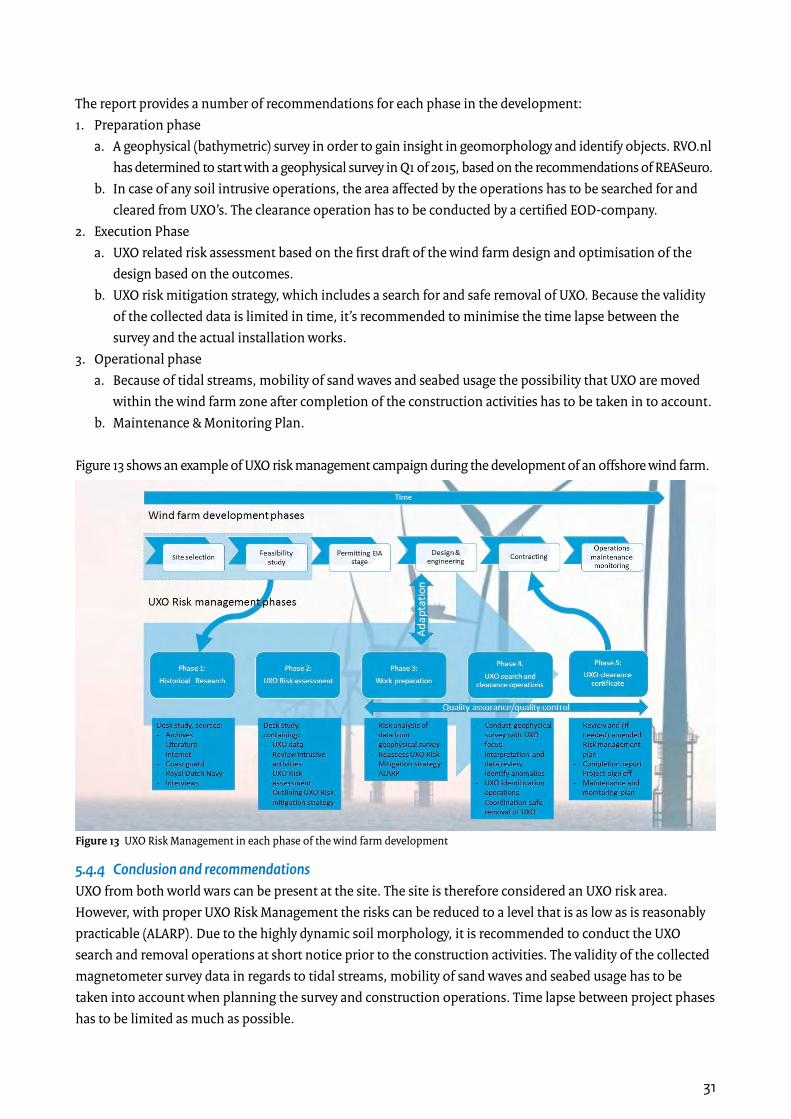
The report provides a number of recommendations for each phase in the development:1. Preparation phase a. A geophysical (bathymetric) survey in order to gain insight in geomorphology and identify objects. RVO.nl
has determined to start with a geophysical survey in Q1 of 2015, based on the recommendations of REASeuro. b. In case of any soil intrusive operations, the area affected by the operations has to be searched for and
cleared from UXO’s. The clearance operation has to be conducted by a certified EOD-company.2. Execution Phase a. UXO related risk assessment based on the first draft of the wind farm design and optimisation of the
design based on the outcomes. b. UXO risk mitigation strategy, which includes a search for and safe removal of UXO. Because the validity
of the collected data is limited in time, it’s recommended to minimise the time lapse between the survey and the actual installation works.
3. Operational phase a. Because of tidal streams, mobility of sand waves and seabed usage the possibility that UXO are moved
within the wind farm zone after completion of the construction activities has to be taken in to account. b. Maintenance & Monitoring Plan.
Figure 13 shows an example of UXO risk management campaign during the development of an offshore wind farm.
5.4.4 Conclusion and recommendationsUXO from both world wars can be present at the site. The site is therefore considered an UXO risk area. However, with proper UXO Risk Management the risks can be reduced to a level that is as low as is reasonably practicable (ALARP). Due to the highly dynamic soil morphology, it is recommended to conduct the UXO search and removal operations at short notice prior to the construction activities. The validity of the collected magnetometer survey data in regards to tidal streams, mobility of sand waves and seabed usage has to be taken into account when planning the survey and construction operations. Time lapse between project phases has to be limited as much as possible.
Figure 13 UXO Risk Management in each phase of the wind farm development

32
5.5 Metocean Study5.5.1 IntroductionThe Metocean Desk Study defines the relevant meteorological and oceanographic (metocean) data that are input for design calculations of tenderers for the Borssele offshore wind zone. The study covers the following aspects:1. Identification of all meteorological and oceanographic parameters that will become part of the design
basis to be used to carry out design calculations for offshore wind farm in the Borssele wind farm zone.2. Identification of relevant meteorological and oceanographic parameters that are input for wave and wind
persistence tables for the wind farms and offshore high voltage stations in the Borssele wind farm area
5.5.2 SupplierDeltares has performed the Metocean desk study [11]. The institute has an extensive track record in offshore wind, with most studies related to topics such as scour prediction and protection, metocean conditions, wave loads, cable burial depth and morphodynamics. Moreover, Deltares has an extensive track record on other offshore wind farms in the near vicinity of the Borssele wind farm zone. DNV-GL has been contracted to certify the methodology and the results of the study. The study is currently finished, but certification is still pending. Therefore, the results of the study, provided below, are still preliminary.
5.5.3 ResultsThe general objective of this study is to determine the metocean conditions (wind, wave, current and other meteorological parameters) present at the Borssele wind farm zone. The metocean report is setup for each of the four wind farm sites separately. In each report, the data presented is related to a specific reference point that has been selected a representative point for the total site.
In order to determine the local variation over each one of the four sites of the BWFZ, dedicated numerical modelling is required for wave, water level and current related parameters. The local modelling simulations cover a relative long period (20 years), sufficient for deriving the requested metocean parameters. These local variations in the metocean parameters are mainly caused by the variation in the bathymetry, i.e. the presence of sand banks and sand waves. Therefore, the numerical modelling will take into account the bed level variation in detail. The wind conditions are based on the high resolution HARMONIE data for KNMI. The project was conducted partly in collaboration with KNMI.
The metocean conditions are assessed by means of detailed analyses of available model (reanalysis) and measurement data. These data are analysed statistically for each selected output location. The analyses comprised normal conditions and extreme conditions, for several recurrence periods of 1, 2, 5, 10, 50 and 100 years, depending on the requirements following the DNV-GL standard. The wind, wave and current normal conditions are computed empirically and given in terms of frequencies of joint occurrences and the extreme climate in terms of return values obtained by means of extreme value analyses. The parameters specifically related to hub height are determined for heights of 70m, 80m, 90m, 100m and 150m.

33
Figure 14 shows an example of the dedicated numerical modelling results: the 50-yr return value of the significant wave height. The effect of the presence of sandbanks and sand waves on the wave propagation is clearly visible.
Figure 14 50-year return value of significant wave height for the Borssele wind farm zone

34
5.6 Assessment Wind Measurement Campaign options5.6.1 IntroductionAn assessment into the added value of carrying out additional wind measurements at the designated wind farm zones in the Netherlands was performed. The aim of the study was to investigate the possibilities to improve wind resource data in the Netherlands’ part of the North Sea with the purpose to use it during project development and FEED studies for the five wind farm zones under development. Improving the data should result in more accurate calculations of the annual energy production, hence lower risk surplus and therefore lower cost of capital. The assumption is that this reduces the project costs and will eventually result in a lower SDE+-grant.
5.6.2 SupplierDNV-GL has performed the assessment of the different options for a wind measurement campaign [12]. DNV-GL is the leading technical advisor in the wind energy industry with decades of experience advising owners, lenders and investors, in particular in respect to wind resource and energy production. The company employs leading experts on remote sensing and in particular on floating LiDAR and has advised on several offshore wind measurement campaigns.
5.6.3 ResultsDNV-GL has described available wind data sets for the North Sea and their usefulness for producing bankable energy assessments. The reported datasets include the offshore meteorological masts at IJmuiden Ver, OWEZ, Fino 1 and Fino 3 and the KNMI measuring platforms Goeree Lichteiland and Europlatform. Figure 15 shows the location of the different masts and platforms.
Figure 15 Location of the different measuring platforms and met masts in the vicinity of the Borssele wind farm zone. The Fino-met masts are described in the report but are located outside this map.

35
Publicly available high quality tall offshore meteorological mast data is available from the existing IJmuiden and OWEZ masts (~ 130-140 km from the Borssele wind farm zone). Combined with publicly available data form Europlatform, Goeree LE and Vlakte van de Raan stations (~30-50 km from the Borssele wind farm zone), these measurements are already expected to provide ‘bankable’ wind data.
Moreover, fixed LiDAR measurements at Goeree have started in October 2014. This information is expected to increase ‘bankability’ of wind data even further. New wind measurement campaigns for the wind farm zones off the coast of North and South Holland are not expected to produce significant gains.
For the Borssele wind farm sites that will be tendered in 2015 (phase 1), measurement results from a floating LiDAR can at maximum be available for a period of 6 months because of the required tendering process and measurement preparations. Therefore, the value of floating LiDAR measurements for the first tender is limited, resulting in less reduction of the uncertainty bandwidth compared to the Borssele sites that will be tendered in phase 2 (currently not the subject of this Project & Site Description), which could benefit considerably from a 12-month onsite floating LiDAR-campaign.
A fixed mast onsite offers the most accurate level of energy yield assessment, but this option is not available due to long deployment times. Therefore, this option has not been considered in the economic assessment.
5.6.4 ConclusionWind data since 2014 from the Goeree LE in combination with the results of 6 months of floating LiDAR measurements provide the best possible dataset that can be used for production calculations for the first tender of sites in Borssele wind farm zone. For the second tender, the results of a 12-month floating LiDAR campaign provide a better dataset that could result in considerable economic benefits. Additional measurements at the wind farm zones off the coast of North and South Holland do not provide added value over already available measurement data of existing meteorological masts nearby.
Therefore, DNV-GL recommends starting the procurement for data collection using an onsite floating LiDAR as soon as possible in order to obtain the longest possible wind data record for Borssele I and Borssele II. Based on these recommendations of DNV-GL, RVO.nl has determined to start onsite measurements with a floating LiDAR in Q1 of 2015.

36
6. Electrical Infrastructure6.1 General introductionTenneT is a leading TSO in Europe, connecting 41 million end users in the Netherlands and Germany. It is the Dutch government’s intention to appoint TenneT as the developer and operator of the offshore grid in the Netherlands [13]. TenneT will construct grid connections for offshore wind farms connecting a total capacity of 3,450 MW.
6.2 Technical ConceptTenneT has drafted a technical concept for connecting offshore wind in The Netherlands. This concept presents the benefits associated with the intention to appoint TenneT as the offshore grid operator for the Netherlands. The key principles of TenneT's design are:• Alternating Current (AC) 220kV connections and future proof design;• The OWF (offshore wind farm) connects directly to TenneT's offshore platform; saving an individual
platform per OWF, thus minimizing the total number of platforms;• Optimisation of wind energy infeed by creating redundancy;• A hub function: the offshore platform includes optionality to function as a hub to future offshore areas
(requirements to scalability, flexibility of the design);• Standardisation and learning effects will contribute to procurement benefits.
This design translates into use of standardised 700 MW platforms. The timing of preparation and realisation can be synchronised with OWFs, avoiding ‘stranded assets’. By compensating reactive power offshore, even future locations further offshore (e.g. IJmuiden Ver) can be connected via AC, which reduces the need for (expensive) high voltage direct current (HVDC). The schematic drawing in Figure 16 shows a generic offshore wind connection in The Netherlands as a result of the abovementioned key principles.
Figure 16 Generic future offshore wind connections in the Netherlands

37
6.3 Locations TenneT platformsTenneT consulted the wind developers, the Ministries of Economic Affairs, Infrastructure and Environment and Rijkswaterstaat (RWS) regarding the locations of the platforms. The proposed platform location (shown in Chapter 4.2) is the result of studies carried out by TenneT and is based on several planning principles:• General planning principles TenneT (accessibility, installation methods, bending radius of the cables)• Spatial planning principles TenneT/RWS (safety zones, cables as much as possible parallel to existing
cables/pipelines, distance to other infrastructure, obstacles, sand mining area)• Specific Borssele requirements from the Ministry of Economic Affairs and Rijkswaterstaat (inter array
cabling of one site not allowed in another site)• Requirements of developers (lowest levelised costs of energy (LCoE), minimal number of cable crossings,
short strings)
The platform and its maintenance and safety zones will be excluded from the wind farm site decision, as well as the cables. The cable corridor has a width of 1600 meter, partly overlapping with the existing safety zone of the Farland North cable. TenneT organises its own spatial permits for the offshore grid as part of a Coordination Regulation for Energy Infrastructure Projects (Rijkscoördinatieregeling or RCR) procedure that has already started. Q1 2015 TenneT will publish the draft Memorandum Scope and Level of Detail (Notitie Reikwijdte and Detailniveau).
6.4 Voltage level for connection (66kV)The technical interface with the wind farm developers will be the MS installation. The wind farm developers are responsible for the inter array cables between the wind turbines. TenneT shall provide transformers with a voltage level of probably 66 kV to 220 kV. Although the final decision has not been made for 66 kV, driven by the desire to realise a future proof design and achieving cost reduction at the same time, a voltage level of 66 kV is considered to be the most suitable option at this moment.
6.5 Commercial conditionsCurrently, the Electricity Act is not applicable outside the 12 nm zone in the Exclusive Economic Zone (EEZ) of the Dutch North Sea and existing Dutch regulation cannot be applied in the EEZ. Amendment of the Electricity Act is foreseen January 1, 2016. Until then, TenneT and wind farm developers shall use private law to agree upon connection and transmission of energy.TenneT has started the development of a legal framework consisting of a so-called REA (Realization agreement) and ATO (Connection and Transmission agreement) supported with a set of non-specific pre-conditions for connecting OWF (generic technical requirements).The offshore wind sector will be consulted during the development of this legal framework. Start of consultation is expected in Q1 2015. The framework must be formally approved by the Dutch authority for consumer and markets (ACM; the Dutch regulator) before the opening of the first offshore tender. Compliance by the tenderers to the legal framework will be obligatory and an inseparable part of the tender of the Ministry of Economic Affairs.
38
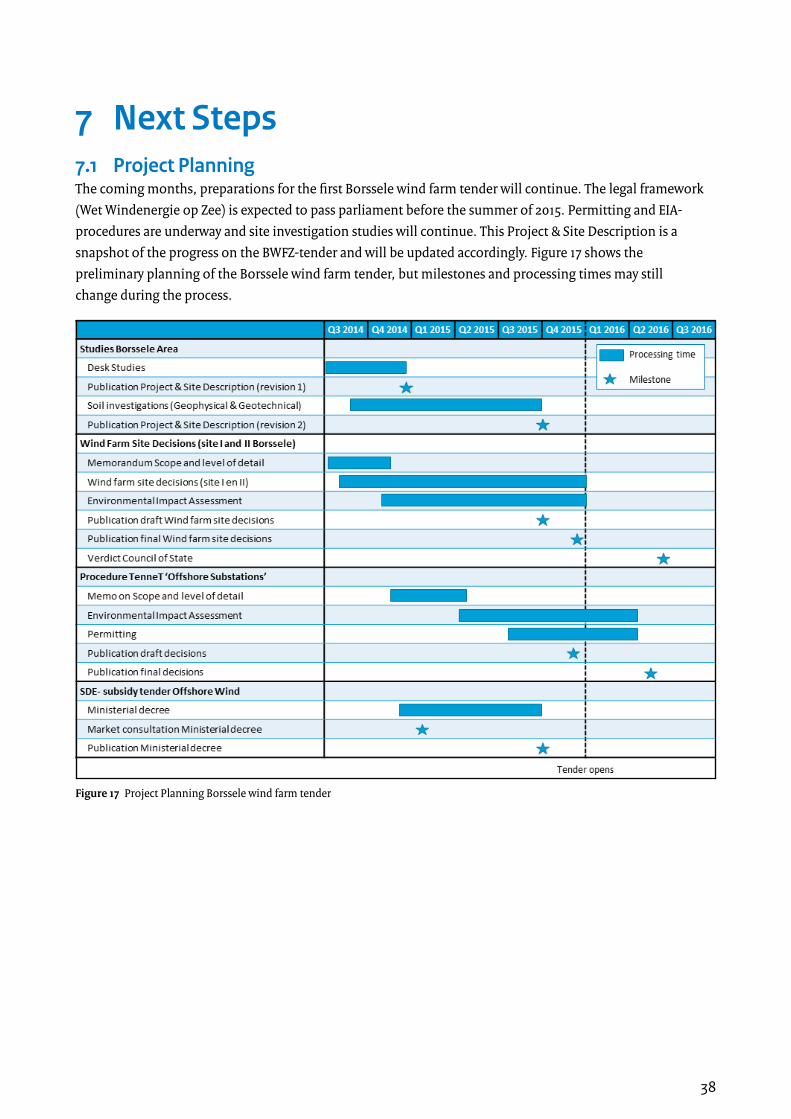
7 Next Steps7.1 Project PlanningThe coming months, preparations for the first Borssele wind farm tender will continue. The legal framework (Wet Windenergie op Zee) is expected to pass parliament before the summer of 2015. Permitting and EIA-procedures are underway and site investigation studies will continue. This Project & Site Description is a snapshot of the progress on the BWFZ-tender and will be updated accordingly. Figure 17 shows the preliminary planning of the Borssele wind farm tender, but milestones and processing times may still change during the process.
Figure 17 Project Planning Borssele wind farm tender

39
7.2 Deliverables and updatesNew studies will be made available on the website and included in the next revisions of this Project & Site Description. The following activities are currently planned:
7.2.1 Geophysical CampaignA contractor will be selected to perform the Geophysical campaign this month in order to conclude the investigation in the first quarter of 2015. Currently the four contractors under the framework contract have been asked to participate in a mini-tender to select the contractor for the execution of the investigation.The goal of the campaign is to provide geophysical data that can be used as input for the (FEED) design process to be carried out by tenderers. The campaign will provide the following data:• Bathymetry data• Side Scan Sonar data• Magnetometer data• Seismic profiling data / sub bottom profiling data• Advice on the scope of the geotechnical site investigations
7.2.2 Geotechnical CampaignBased on the results of the geophysical campaign, a geotechnical campaign will be performed, the data of which can be used for the design process of the tenderers. Framework contracts with four suppliers are being concluded at this moment and the procedure to select the contractor for carrying out the geotechnical investigation is planned to take place in the first months of 2015. Planning is that that the geotechnical investigation will start as the results of the geophysical campaign become available and the final positions for executing the boreholes and piezo cone penetration tests can be determined.
The investigation will include the following activities:• A sufficient number of boreholes / and CPT’s carried out at representative locations over the total wind
farm zone or concession.• Laboratory tests carried out on the samples that were obtained through the soil investigation.• Interpretation of the borehole and CPT results.• Description of the correlation between the results of the geological desk study, geotechnical investigation
and the results of the geophysical investigation
7.2.3 Update morphodynamical studyThe current morphodynamical study is a desk study, which is based on higher quality data from 2010 and lower quality data from around 2000. After the geophysical campaign, the morphodynamical study will be updated and validated using the new high quality data. Moreover, the study will provide recommendations regarding the expected seabed level variability over the wind farm area.
7.2.4 Geological modelThe data of the geotechnical and geophysical studies will be used to create a geological model for the site. The objective of this geological model is to get insight in overall stratification and the soil conditions of the wind farm site and to identify possible constraints for the design and installation of offshore wind farms.

40
7.2.5 Wind Resource AssessmentThe goal of the study is to provide the wind data that can be used as input for wind farm modelling and business case calculations. The study will cover the following aspects:• Description of the long-term wind conditions• Assessment of available data sources for carrying out the wind resource assessment• Assessment of general wind conditions at the site including detailed information on: - Average wind speed - Turbulence intensity - Air density - Wind shearThe study is planned to be executed in the first quarter of 2015.
7.2.6 Wind MeasurementsBased on the recommendations of DNV-GL, a measurement campaign will be performed. These measurements will contribute to narrowing down the uncertainty bandwidth regarding the wind resources at the site. The wind speed measurements at the Borssele wind farm zone will be performed by means of a floating LiDAR. Possibly, these measurements will be combined with oceanographic measurements such as wave- and current measurements. Further, it is considered to measure wind speeds at different locations of the wind farm zone in order to get insight in possible wake effects of the wind farms at the Belgian side of the border. Decisions on the exact scope of the measurements are pending on the outcome of the procurement process for this investigation, which is currently underway. The intention is that at least 6 months of measurement data is obtained during the wind measurement campaign.
7.2.7 Update of Wind Resource AssessmentAfter the Wind Measurement Campaign, the Wind Resource Assessment will be updated and validated using the measurement data obtained at the site.
7.2.8 Environmental Impact Assessment / Bandwidth for design characteristicsPondera Consult and Grontmij are currently preparing the Environmental Impact Assessment (EIA). A Memorandum Scope and Level of Detail (scoping document) was prepared, which indicates what has to be investigated and stakeholders could comment on it (term recently expired). This document includes the preliminary bandwidth for design characteristics shown in the previous chapters.
In the near future, when the EIA has been prepared and together with the site decisions made available for comments, the EIA Commission will also review it. Based on the responses and the advices, the EIA and updated bandwidth for design characteristics will be finalised and included in the Project & Site Description.
7.2.9 Update of project & site descriptionThis Project & Site Description will be updated twice. Superseded studies will be removed, others will be updated and new ones will be included. Moreover, planning and other details will be updated in the new version. A new version of the Project & Site Description will be ready in Q3-2015, a final version will follow when the subsidy tender opens.

41
8 Applicable documents[1] Energy Agreement for Sustainable Growth, September 6th 2013 (Available in English and Dutch)
[2] Ontwerp-Rijksstructuurvisie Windenergie op Zee, December (Available in Dutch)
[3] National Water Plan 2009-2015, December 22nd 2009 (Available in English and Dutch)
[4] Policy Document on the North Sea 2009-2015, December 22nd 2009 (Available in English and Dutch)
[5] Memo Site Investigations Zones, December 2nd 2014
[6] Integrated North Sea Management Plan, 2015
[7] Geological desk study, December 2014 (Available in English)
[8] Morphodynamics of Borssele Wind Farm Zone, Deltares, December 2014
[9] Archaeological desk study, risk assessment and recommendations, Vestigia, December 2014 (Available in English)
[10] Unexploded Ordnance (UXO) – Desk Study, REASEuro, December 2014 (Available in English)
[11] Metocean study for Borssele Wind Farm Zone Site 1, Deltares, December 2014
[12] Assessment Wind Measurement Program North Sea, DNV-GL, October 2014
[13] Kamerbrief Wetgevingsagenda STROOOM (Letter to Parliament Energy Legislative Agenda), June 18th 2014 (Available in Dutch)
42
This website is managed by the Netherlands Enterprise Agency, an agency of the Dutch government concerned with international business and cooperation. Whilst a great deal of care has been taken in compiling the contents of this site, the Agency can not be held liable for any damages resulting from any inaccuracies and/or outdated information.
This research report is commissioned by RVO.nl, agency of the Ministry of Economic Affairs, and drafted with great care. RVO.nl cannot guarantee the completeness and accuracy of all information in this report. RVO.nl does not accept liability as a result of the use of this research report.
Coverphoto: nuon/Jorrit Lousberg
ContactsNetherlands Enterprise Agency (RVO.nl) Croeselaan 15 | 3521 BJ | UtrechtP.O. Box 8242 | 3503 RE | Utrecht www.rvo.nl / http://english.rvo.nl
Netherlands Enterprise Agency (RVO.nl) | December 2014