boronów, lubliniec county, -...
TRANSCRIPT

Boronów, Lubliniec County,Silesian Voivodeship,
Poland
Descriptive Data and Mapsby
Charles Ciechanowski-Chinoski-Chase

Map of Poland & 16 Provinces
Silesian (śląskie)Voivodeship
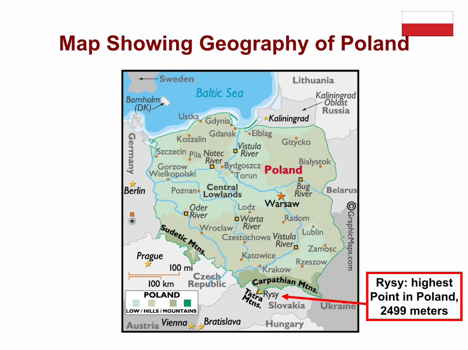
Map Showing Geography of Poland
Rysy: highestPoint in Poland,
2499 meters

Map Showing Rivers of Poland
Warta (Liswarta)River runs through
Boronów

Background of Poland• Poland is an ancient nation that was conceived near the middle of the
10th century. Its golden age occurred in the 16th century. During the following century, the strengthening of the gentry and internal disorders weakened the nation. In a series of agreements between1772 and 1795, Russia, Prussia, and Austria partitioned Poland amongst themselves. Poland regained its independence in 1918 only to be overrun by Germany and the Soviet Union in World War II. It became a Soviet satellite state following the war, but its government was comparatively tolerant and progressive.
• Labor turmoil in 1980 led to the formation of the independent trade union "Solidarity" that over time became a political force and by 1990 had swept parliamentary elections and the presidency. A "shock therapy" program during the early 1990s enabled the country to transform its economy into one of the most robust in Central Europe, but Poland currently suffers low GDP growth and high unemployment. Solidarity suffered a major defeat in the 2001 parliamentary elections when it failed to elect a single deputy to the lower house of Parliament, and the new leaders of the Solidarity Trade Union subsequently pledged to reduce the Trade Union's political role. Poland joined NATO in 1999 and the European Union in 2004.

Poland: Geography• The Republic of Poland (Polish: Rzeczpospolita Polska) is one of the
largest countries in Central Europe. It borders Russia, Lithuania, Belarus, Ukraine, Slovakia, the Czech Republic and Germany. Its northern frontier on the Baltic Sea gives it easy access to Scandinavian and North Sea ports.
• The capital of Poland, Warsaw, is situated right of center in the country. Poland ranks eighth in Europe in terms of size with a surface area of 312,677 sq. km, which constitutes about 3% of the continent's surface.
• The country lies almost wholly on the North European Plain and is a land of gentle slopes, rarely rising above 300 m, except along the southern border with the Sudetic and Carpathian Mountain ranges.Rysy, the highest mountain peak rises 2499 m above sea level.
• Approximately one-fifth of the land is maintained as pasture and meadows. Forests cover over 28% of the total area. The longest rivers cross the country northwards: the Vistula (1074 km in length) in the centre, and the Odra (854 km), which flows along Poland's Western border.
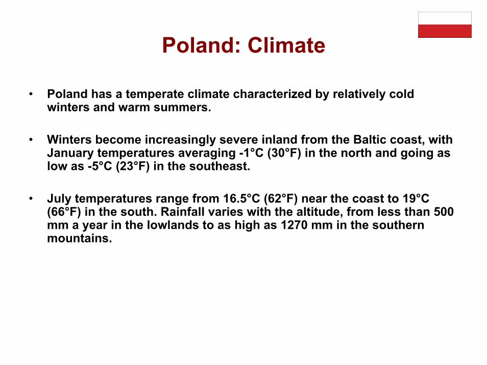
Poland: Climate
• Poland has a temperate climate characterized by relatively cold winters and warm summers.
• Winters become increasingly severe inland from the Baltic coast, with January temperatures averaging -1°C (30°F) in the north and going as low as -5°C (23°F) in the southeast.
• July temperatures range from 16.5°C (62°F) near the coast to 19°C (66°F) in the south. Rainfall varies with the altitude, from less than 500 mm a year in the lowlands to as high as 1270 mm in the southern mountains.
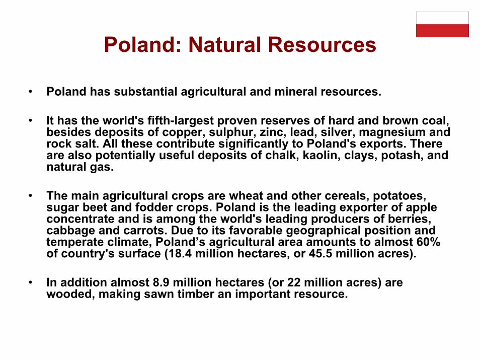
Poland: Natural Resources
• Poland has substantial agricultural and mineral resources.
• It has the world's fifth-largest proven reserves of hard and brown coal, besides deposits of copper, sulphur, zinc, lead, silver, magnesium and rock salt. All these contribute significantly to Poland's exports. There are also potentially useful deposits of chalk, kaolin, clays, potash, and natural gas.
• The main agricultural crops are wheat and other cereals, potatoes, sugar beet and fodder crops. Poland is the leading exporter of apple concentrate and is among the world's leading producers of berries, cabbage and carrots. Due to its favorable geographical position and temperate climate, Poland’s agricultural area amounts to almost 60% of country's surface (18.4 million hectares, or 45.5 million acres).
• In addition almost 8.9 million hectares (or 22 million acres) are wooded, making sawn timber an important resource.

• The population of Poland is currently 38.7 million people. Approximately 62% of Poles live in 880 cities, which are mostly small or medium-sized, and half the population lives in 42 cities with a population of over 100,000 inhabitants. Warsaw, the capital and Poland's largest city has a population of 1.6 million people.
• Poland ranks 8th in Europe and 29th in the world, with an average population density of 124 persons per km2. The population of Polish communities abroad is estimated at 12 million, with the largest communities living in the USA (5.6 million), Commonwealth of theIndependent States - CIS (2.5 million), France (1 million), Germany (0.8 million), Canada (0.4 million), Brazil (0.2 million), Australia (0.15) and the UK (0.14).
• From the ethnic point of view, Poland is one of the most homogeneous countries in Europe, with over 98% of the populationbeing of Polish ethnic origin. In the business community, as well as among young people, English is the most popular foreign language. Further, reflecting the geographical position of the country, German and Russian are frequently spoken.
Poland: Population & Language

• Poland was the first country in Central and Eastern Europe to break out of communist rule. Major agreements with the communists led to the legalization of the "Solidarity" trade union and an agreement to hold elections on 4 June 1989, which were won by the representatives of "Solidarity" (Lech Walesa) who formed the first non-communist government since the Second World War. Poland is a republic adopting a mixture of parliamentary and presidential models. In 1997 a new Constitution was adopted.
• The President, elected by general election for a 5-year term, appoints candidates for Prime Minister and has the right to veto acts passed by Parliament. He has the right to dissolve Parliament if it is unable to approve the budget law or to form a government. Legislative authority is vested in the Parliament or National Assembly composed of twoChambers: the lower house, the Sejm, and the upper house, the Senate (both elected for a 4-year term).
• Executive powers are vested in the Prime Minister and his Cabinet, called the Council of Ministers, while judicial power is vested in independent courts. Poland is a member of the European Union (EU) and NATO.
Poland: Political System & Government
Overview of Voivodeships
• The voivodeship (Polish: województwo), or province, has been a high-level administrative subdivision of Poland since the 14th century. Pursuant to the Polish local government reforms passed in 1998, which came into effect on January 1, 1999, sixteen new voivodeships were created. These replaced the 49 former voivodeships that hadexisted from July 1, 1975.
• Today's voivodeships are largely based on the country's historicregions, while those of 1975–1998 were centered on and named for individual cities. The new units range in area from under 10,000 km2 (3,900 sq mi) (Opole Voivodeship) to over 35,000 km2 (14,000 sq mi) (Masovian Voivodeship), and in population from one million (Lubusz Voivodeship) to over five million (Masovian Voivodeship).
• Administrative authority at voivodeship level is shared between a government-appointed governor called a voivode (Polish wojewoda), an elected assembly called a eimik, and an executive chosen by that assembly. The leader of that executive is called the marszałek województwa (voivodeship marshal). Voivodeships are further divided into powiats (counties) and gminas (communes or municipalities).
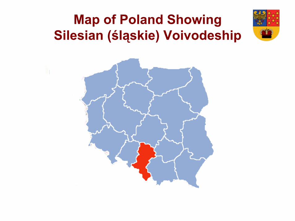
Map of Poland ShowingSilesian (śląskie) Voivodeship

Map of Silesian Voivodeship
Lubliniec County(Powiat Lubliniecki )
BoronówGmina
Lubliniec
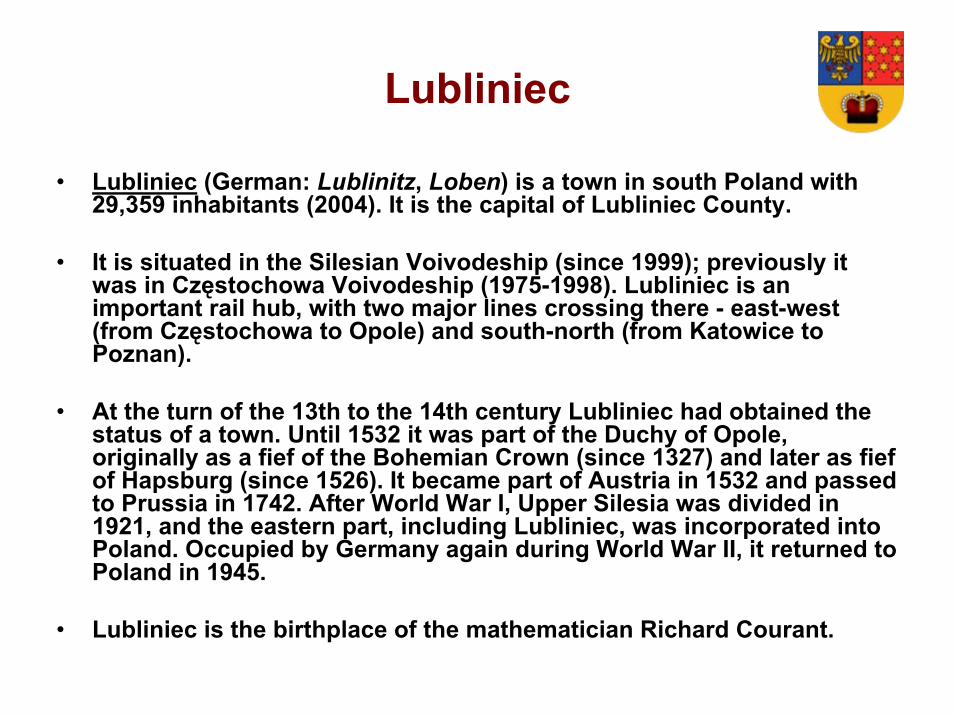
• Lubliniec (German: Lublinitz, Loben) is a town in south Poland with 29,359 inhabitants (2004). It is the capital of Lubliniec County.
• It is situated in the Silesian Voivodeship (since 1999); previously it was in Częstochowa Voivodeship (1975-1998). Lubliniec is an important rail hub, with two major lines crossing there - east-west (from Częstochowa to Opole) and south-north (from Katowice to Poznan).
• At the turn of the 13th to the 14th century Lubliniec had obtained the status of a town. Until 1532 it was part of the Duchy of Opole, originally as a fief of the Bohemian Crown (since 1327) and later as fief of Hapsburg (since 1526). It became part of Austria in 1532 and passed to Prussia in 1742. After World War I, Upper Silesia was divided in 1921, and the eastern part, including Lubliniec, was incorporated into Poland. Occupied by Germany again during World War II, it returned to Poland in 1945.
• Lubliniec is the birthplace of the mathematician Richard Courant.

Lubliniec County (Powiat Lubliniecki )
Voivodeship Silesian
Gminas 8
Area-Total 317.4 sq-mi
Population(Total, 2006)
76,628
Lubliniec Coat of Arms
The 8 Gminas of Lubliniec County
BoronówGmina
Gmina Boronów
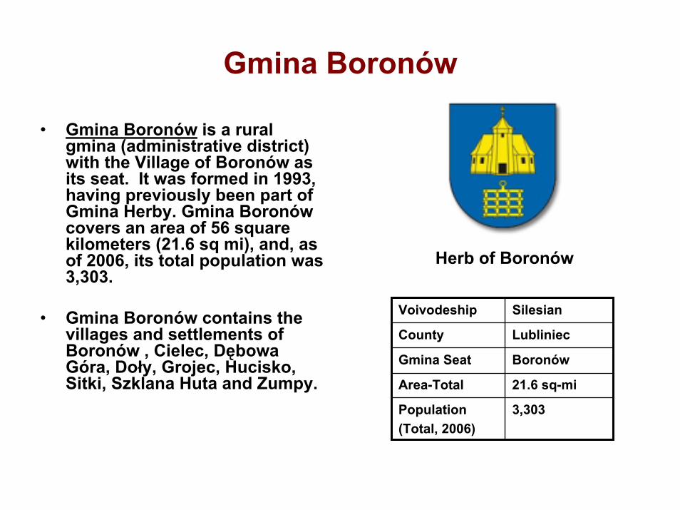
• Gmina Boronów is a rural gmina (administrative district) with the Village of Boronów as its seat. It was formed in 1993, having previously been part of Gmina Herby. Gmina Boronówcovers an area of 56 square kilometers (21.6 sq mi), and, as of 2006, its total population was 3,303.
• Gmina Boronów contains the villages and settlements of Boronów , Cielec, Dębowa Góra, Doły, Grojec, Hucisko, Sitki, Szklana Huta and Zumpy.
Herb of Boronów
Voivodeship Silesian
County Lubliniec
Gmina Seat Boronów
Area-Total 21.6 sq-mi
Population(Total, 2006)
3,303

Map of Gmina Boronów

Village of Boronów
Seat of Gmina Boronówin
Silesian Voivodeship

Brief History of Boronów• The written history of Boronów
begins in the 13th century in documents of Casimir III, but in that area older relicts from the Neolithic era and Lusatian culture were found by archeologists in the 1920s.
• In 1611 a wooden church was founded by Andrej Dzierźanowski, owner of Boronów.
• In the 19th century the village belonged to the Hohenlohe-Ingelfingen family. At this time it was a small industrial village. In its area there were two mines of ore, two breweries and a sawmill. Both mines were the largest in the whole district of Lubliniec.
Map of 19th Century Boronów

Village of Boronów• Boronów [bɔ-rɔnuf] is a village in Lubliniec County, Silesian
Voivodeship, in southern Poland. It is (since 1993) the seat of the gmina (administrative district) called Gmina Boronów. It lies approximately 16 kilometres (10 mi) east of the city Lubliniec and 47 km (29 mi) north of the regional capital Katowice. Boronów is on the Warta (Liswarta) River [1] , which has a length of 808 km. The village has a population of 2,793. Between 1975 and 1998 it was in the former Częstochowa Voivodeship.
• The name Boronów possibly originates from the coniferous forests (Polish: bory) in the area, or, possibly, from the surname Boronowski, who was one of owners of this village. In old chronicles the names Borunow and Bornów are found. But on the herb (coat of arms) of Boronów there is a harrow (an agricultural implement with spike-like teeth or upright disks, drawn chiefly over plowed land to level it, break up clods, root up weeds, etc.), because it was a sign on the old village's stamp (used to wax seal mail). Some chronicles show the name of the village in a different way: Borunow, Boronów, Bornów. The Bornów name is still popular among residents.
[1]: The Warta (Liswarta) River Basin was the original Poland - it is said that the Polans, (also known as Polanes, Polanians or Polians; Polish: Polanie) a West Slavic tribe, inhabited the Warta river basin from the 8th Century.

History of the Village of Boronów• The first mention of the village name of Boronów appears in the 1341
documentation on the regulation regarding the border area of thelands of Casimir the Great. This record contains the message that the town belonged to the Duchy of Opole. Actually, settlement in this area appeared much earlier. Discoveries in the environs of Boronów trace back to the Neolithic Period [1] and the Lusatian Culture [2].
[1] Neolithic Period: A period in the development of human technology, beginning about 9500 BCE that is traditionally considered the last part of the Stone Age. The Neolithic Period was the beginning of the rise of farming, and ended when metal tools became widespread, includingthe use of wild and domestic crops and the use of domesticated animals
[2] Lusatian Culture: Existed in the later Bronze Age and early Iron Age (1300 BC-500 BC) in most of Poland, parts of Czech Republic and Slovakia, parts of eastern Germany, and parts of Ukraine
History of the Village of Boronów
• Archaeological research was carried out in Boronów in the 20th Century by Joseph Kostrzewski, Konrad Jażdżewski and Vladimir Antoniewicz. In 1928 they discovered simple stone tools from the Stone Age in the vicinity of the Boronów District of Piasek (Sand). Earlier in 1925, in the vicinity of the District Smolny, were discovered the remains of a cemetery with graves containing skeletons along with items such as necklaces, earrings and utensils: i.e., bowls and buckets.
• In 1358, Prince Albert of Opole was the owner of the village of Boronów. In 1532 Boronów was in the hands of the Piast (hub) Opole. At the beginning of the 17th century the village belonged to a family with the surname Dzierżanowskich.

The Residents of the Boronów Village
• Most of the residents of Boronów have been living in this area for several generations, thus identifying the cultural aspects of this area of Upper Silesia. Some of the inhabitants are descendants of German settlers polonized from the eighteenth and nineteenth centuries, immigrants (and their descendants) from Opole Silesia came during the Silesian uprisings, as well as families of repatriates, who came to town from the Eastern Border Regions after World War II. Some residents belong to the German minority.
• A large proportion of the population uses the Silesian dialect. A clear majority of residents are Roman Catholic people. A few people are Jews, Jehovah's Witnesses and Protestants.

Boronów’s Catholic Church: History• Church of Our Lady, Queen of the Holy Rosary: a wooden church
built in 1611, situated in the village of Boronów, in the Diocese of Gliwice. Built on a Greek cross plan. It is the oldest wooden church in Silesia of that plan.
• The founder of the church was Count Alexander Edward Dzierzanowski. In 1638 Earl Dzierzanowski purchased the church bell which still hangs in the Church’s bell tower. Most of the sacred objects currently held in the church date from the seventeenth and eighteenth centuries. In addition to the main altar, there are also four side altars, located in the south and north aisles: – Altar of St. Anne of the seventeenth century– Altar of the Immaculate Conception of the Virgin Mary in 1659,– Altar of the Four Johns of the eighteenth century– Altar of St. Nicholas 1751

Boronów’s Catholic Church: Overview
Built 1611Religion Roman CatholicParish Parish of Our Lady,
Queen of the Holy RosaryType of Church ParishName of Church Mary Queen of the Holy
RosaryDiocese Gliwice
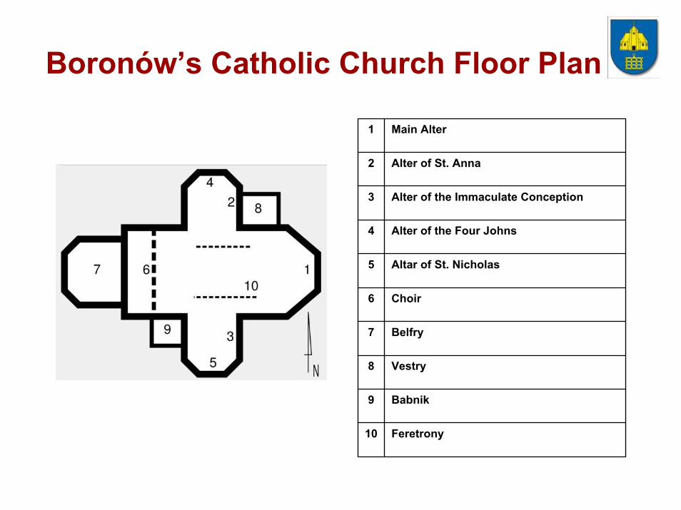
Boronów’s Catholic Church Floor Plan
1 Main Alter
2 Alter of St. Anna
3 Alter of the Immaculate Conception
4 Alter of the Four Johns
5 Altar of St. Nicholas
6 Choir
7 Belfry
8 Vestry
9 Babnik
10 Feretrony

Boronów’s Catholic Church: Interior
Main Altar Detail of the Main Altar
Feretrony of the Rosary Society

Photos of Boronów
Village Sign 19th Century Home
Boronów School Old Mill in Hajduki District
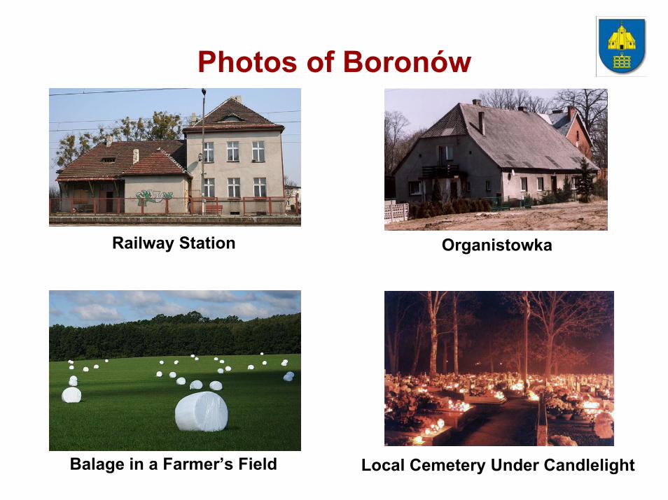
Photos of Boronów
Railway Station Organistowka
Balage in a Farmer’s Field Local Cemetery Under Candlelight

Districts of Boronów Village
• Siodłoki - one of the oldest districts of Boronów, located on the left bank of the Liswarta (Warta) River. In this part of town are mostly farms. From the river in this district are many buildings from the beginning of the twentieth century and in some cases from the nineteenth century. There are several shops and services.
• Hajduki - a district in the central part of the village, located on Liberty Street. In its area, there is a church, rectory, the bank, and some industry and food stores. At the beginning of the twentieth century, there was a mill in this district.
• Zamoście - a district which is an extension Hajduków. Most housing was built after World War II. It is located in the little shops and services. There was also, already closed restaurant "Borowianka", located in the building, which has more than 200 years he served as an inn. In turn, the extension is a relatively new part Boronowo, which are known as Siudejka, joining sołectwami Grojec and Hucisko.

Districts of Boronów Village
• Smolny Piec - built-up area in the second half. Twentieth century, having a residential character. None of the stores, a few points of service. Is located along the streets and Niwskiej Polna, and connecting them blocks. Earlier in the district produced charcoal. In the two decades interwar found it a few graves from the era ciałopalnych Lusatian culture.
• Piasek (Sand) - a district in the western part of the village. In this area there is a building shared by the Municipal Cultural Center, library, medical clinic, pharmacy, fire station and post office. These institutions and several shops are located on top of the street Silesian Insurgents. Most of the remainder of the district is residential. Also within Piasek is a team Placówek Educational Complex, including kindergarten, elementary school and high school.

Districts of Boronów Village
• Dwór (Manor) - a district created in the nineteenth century, primarily for the peasants working on farms. At the time of the creation, an agricultural cooperative was formed in the three blocks of flats for the employees of that cooperative. The district has a multi-branch store-(“Leviathan“), in the old tavern building, and a deli, a former kindergarten building, and a warehouse-store for construction materials. There is a sports club ("Unity“) and the Office of Municipal Boronów.
• Zdachnia - district, located along the "rabbit Górka" on the south side of the railway line. Name of the district derives from the name of the local surrounding fields. It is located on the only street, Sienkiewicz.

Boronów Under the Rule of Prussia
• In 1742, Boronów became a part of Prussia. Since the year 1774, the village formed the colonies Debowa mountain, Zumpy and Niwa, in which German was mainly spoken.
• Since the year 1805, Boronów was owned by the family of Hohenlohe-Ingelfingen. In the nineteenth century, with industrialization of the village, there was a significant increase in the number of residents in the surrounding area. In 1840 Boronów had 1781 inhabitants, while Lubliniec had 2114. In third place was the city of Woźniki, with 1259 residents. At this time, Boronów had an iron ore mine and forges which employed over 100 people. Since then it is known for mining ore and smelting iron. There are some sources of historical evidence that say such operations already existed in 1645.

Boronów Under the Rule of Prussia
• Even though the village, in the 19th century, developed industry, it was still mainly agricultural in nature. After the abolition of serfdom in Prussia in 1811, Boronów began to develop and employ peasants to work the farms. In 1860, there was a collapse of the mining and forging industries, Therefore, farming grew to become even more important because it provided employment for the landless people. Apart from heavy industry and agriculture at that time, Boronów was also developing a processing industry: the village had a distillery, two breweries, a sawmill and three water mills.

Boronów During World War II
• During the years of World War II, the village carried on fairly safely because it was on the outskirts of the short-term struggles in 1939, and the skirmishes of the retreating German army caused by the Soviet offensive of January 19, 1945. Dozens of German and Russian soldiers died during these skirmishes, but the local residents were reasonably safe.
• Polish soldiers killed in September 1939 were buried in the local cemetery. However, the 61 German soldiers killed in the Russianskirmish were buried outside of the boundaries of Boronów’s cemetery. Russian soldiers were buried in the Boronów cemetery, but were exhumed several years after the war and sent to off-site locations. After 1953 the cemetery was enlarged, so that it included the collective grave of the fallen Germans.

Boronów During Communist Rule
• After World War II, the private estates were broken up into a series of farms which were parceled out. In 1951 this led to the creation of a farm cooperative called “Unity”. The sawmill and other still-active workshops were gradually dismantled.
• In 1959 Boronów was given the use the newly built School. More and more residents of the village at that time were employed in mines. During the 1970s and 1980s there was a mass exodus of people to West Germany, especially those who could prove they were of German descent.

Boronów in the Third Republic
• After 1989, as a result of privatization, most of the workers of the Cooperative "Unity" lost their jobs. In 1993, Boronów regained its status as headquarters for the Boronów rural community, Gmina Boronów.
• In the western part of Boronów, in the surrounding fields known as Rabbit Hill, were discovered large areas covered with scrap metal which originated from the landfill in Herby. It is obvious that Boronów has some major ecology challenges.
• In the 1990s Boronów initiated a new telephone network, and began construction of the sewerage system. Since 1999, the wastewater treatment plant is fully operational.

Map of Boronów’s Environs
Boronów

Dębowa Góra, Lubliniec, Silesian Voivodeship, Poland
• Dębowa Góra [dεm bəva gura]is a very small village in the administrative district of Gmina Boronów, within Lubliniec County, Silesian Voivodeship, in southern Poland. It lies approximately 3 kilometres (2 mi) north-east of Boronów, 18 km (11 mi) east of the city of Lubliniec, and 49 km (30 mi) north of the regional capital Katowice.
• The village has a population of 111.
Boronów
Dębowa Góra
2 miles