bondi park and pavilion heritage review
TRANSCRIPT

Mayne-Wilson & Associates Conservation Landscape Architects
BONDI PARK AND PAVILION HERITAGE REVIEW
Prepared for
Waverley Council
by
Mayne-Wilson & Associates
Conservation Landscape Architects Paddington NSW 2021
November 2012

Mayne-Wilson & Associates Conservation Landscape Architects
T A B L E O F C O N T E N T S Page
1.0 Introduction 1 1.2 The Study Area 2 1.3 Methodology 2 1.4 Limitations 3 1.5 Authorship 4 1.6 Acknowledgments 4
2.0 Historical Overview 4 2.1 Post Settlement Timeline 4 2.2 Thematic History 9 3.0 Heritage Significance 63 3.1 Statement of Significance 66 3.2 Table of Heritage Items 68 3.3 Biddigal Reserve 89 4.0 Constraints & Opportunities 90
5.0 Client requirements & feasible uses 91
6.0 Conservation Policy 92
7.0 Conservation management and actions 93 7.1 Summary of Action Plans 93 8.0 Concluding remarks 94 Summary of modifications to the pavilion and Bondi Surf Club building 96 List of Special Exemptions obtained by Council 97 Appendix A – A history of Norfolk Island Pine plantings Appendix B – Details of the 1928 improvements and new facilities Appendix C Current photographic record, arranged in Strategic Asset Plan3 zones

1
Mayne-Wilson & Associates Conservation Landscape Architects
1.0 Introduction
Waverley Council has initiated the process of preparing a new Plan of Management for Bondi Park and Pavilion, which will provide strategic and operational direction for the management of the park. Heritage is an important value of Bondi Park and will be important in the development of the new Bondi Park and Pavilion Plan of Management.
As both are listed as heritage places and items on National, State and local heritage registers, as well as on that of the National Trust, the Council requires a heritage study to be undertaken to identify the components of the Park and Pavilion which are of heritage significance. The heritage items and values identified for the Park are fragmented through different documents. A Bondi Park and Pavilion Heritage Review Study was therefore needed to consolidate this information and recommend how these items and values should be protected and managed into the future.
The tasks which Council required to be performed are:
o Confirm all registered heritage items/areas and any additional items/areas that need to be added o Photograph them and map them o o Prepare a thematic history of Bondi Park in consultation with La Perouse Local Aboriginal Land Council
and Local Studies Librarian including a timeline and a list identifying key images o Prepare a Statement of Significance for the Park and Pavilion o Identify issues and opportunities for the heritage value of the Park and Pavilion o Recommend a management strategy for the items/areas based on existing heritage legislation and best
practice o Prepare an objective for the heritage value o Prepare an action plan for the heritage value (action/priority/outcome) After calling for an expression of interest and quotation from selected consultants, Council engaged Mayne-Wilson & Associates (MWA), Conservation Landscape Architects of Paddington on 3 August to undertake the above tasks. It was agreed that a complete site survey should be undertaken of the Park and this was finally completed and made available on 26 October. Council also offered to assist MWA to liaise with and secure the agreement of the La Perouse Aboriginal Land Council to obtain approval of a draft history of the Aboriginal presence in and use of the area.
Discussions were held as to whether the Icebergs Swimming pool and building should be included within the study area, but as they are on Crown Land and are managed under a separate Trust, it was agreed that they should not. However, it was acknowledged that these ocean baths/swimming pools played an important early role in the public’s visitation to Bondi beach, and that some reference to them would be made in this Report.
The consultants had made it clear in their submission that they did not intend to provide a detailed analysis of the pavilion or the actions that needed to be taken with regard to its physical condition, since this had already been done by experts in 2007, in tabulated form, and with subsequent detailed estimated costings. This approach was accepted by the Council officers. It had also been studied in detail in 1997 by Clive Lucas, Stapleton & Partners in their Conservation Analysis and Conservation Guidelines, hereafter referred to, for convenience as the CLS& P CMP.

2
Mayne-Wilson & Associates Conservation Landscape Architects
1.2 The Study Area
Fig. 1 The study area is defined by the red line. It does not include Notts Avenue nor Campbell Parade per se, but does include the retaining walls that provide the boundaries with those roadways, as well as a sense of enclosure for the Park. The study area includes the Wally Weekes tidal pool and children’s wading pool and Biddigal Reserve in the north, as well as the Scarborough Crescent sandhill. Note the cleft in the ocean floor, which indicates the valley of an ancient river that formed during the last ice age between 18,000 - 10,00 years ago when sea levels were at least 20 - 45m lower than today. 1.3 Methodology
A start-up meeting introduced the several Council Officers who have some responsibilities towards the park and relations with the community and its stakeholders. Ms Bianca Simpson, Open Space Planning Manager, assumed the role of project manager and point of liaison with MWA. Ms Kimblerly O’Sullivan, Local Studies Librarian also attended the meeting and agreed to provide as much information and assistance to MWA as possible from her library collections.
The Consultant Team comprised Warwick Mayne-Wilson, Principal of MWA, and his associate Ari Anderson, who has worked as a subconsultant to MWA for 16 years on many of their heritage projects. Together they photographed and recorded all relevant items and open spaces within the Park and Biddigal Reserve, down- loading them subsequently into tables in accordance with the zones marked on Council’s assets register. Ari then undertook extensive research at the Local Studies library of the material provided by Ms O’Sullivan, supplemented by searches on the internet, principally via Trove, Pictures Australia, the National Library, and the Mitchell Library. Warwick also undertook follow-up research in the Local Studies Library.

3
Mayne-Wilson & Associates Conservation Landscape Architects
All this material was analysed, and a draft timeline prepared, to be added to as new information came to hand. After some experimentation, a format for the Thematic History was developed, drawing some inspiration from that contained in the Heritage Office’s Inventory Sheet “Bondi Beach Cultural Landscape’. However, it was found that although the Australian, State and Local themes were listed, there was no linkage or correlation between them and the actual heritage items in that landscape. What was missing was how these sets of themes were physically demonstrated in the Park by what items or places.
Accordingly, the consultants decided on a dual approach. The first was to compile a table of themes that were considered to be relevant to the Park and Pavilion. The table was divided into four columns, the first citing the appropriate Australian theme, the second the NSW theme (where it existed), the third column the local theme (extracted from the Heritage Office inventory sheet), and the fourth column stating in what way this theme was demonstrated in the Park and pavilion. This table was then placed at the beginning of the Thematic History of the Park, and appropriate headings were taken from it, using numbers where the Australian theme was referred to. (State and local themes have no numbers.) The Thematic History therefore differs somewhat from the normal history-as-narrative, although it has been written in a way which allows the evolution of the Park and Pavilion to unfold and be understood.
The second approach was to prepare an illustrated table showing each item considered to be of heritage significance, to rate it in terms of exceptional, high, moderate or low significance, and accompany it with historical photographs and a few background words. In the heritage rating column, brief advice was provided on the appropriate action to protect and conserve this item or space. This latter was then extracted from the Tables to form the basis for the Action Plan required by the Brief.
A draft history of Aboriginal presence and use of the area was then prepared, based on the Waverley Aboriginal Cultural Heritage Study prepared by Dominic Steele Consulting Archaeology in May 2009 and an earlier study by Elida Meadows for Council. A copy was sent by Council to the La Perouse Aboriginal Land Council for consideration and possible provision of additional information, but this has not yet been received at the time of completion of this Report.
An over-arching State of Heritage Significance was then prepared, drawn mostly from those already written but modified or added to where considered necessary. Following this, broad conservation policies and management strategies for the heritage elements (only) were outlined. Formal heritage processes and statutory controls were identified, and Council was requested to confirm whether the list of standard exemptions of 2008 cited in the NSW Heritage Inventory Sheet applied. They advised that in addition to those, Council had obtained numerous other exemptions. These are shown at the back of this Report.
As a quality control measure, the initial draft of this Report was sent to Dr Mary Casey of Casey & Lowe Archaeologists, and her advice taken into account. [It is pertinent that Dr Casey spent her childhood and her early working years in Bondi, so has had a personal experience of the evolution of the Park and beach.]
As the consultants have made extensive use of old photographs, plans and drawings throughout this Report, it was decided to identify the source of each one as part of the caption, rather than put this in a separate list.
1.4 Limitations
As Council wished the Heritage Report to be prepared within four weeks, there was a considerable pressure to undertake the research and compile the material into a thematic history. As noted above, no

4
Mayne-Wilson & Associates Conservation Landscape Architects
independent research was undertaken on Aboriginal history, nor on the interior condition of the Pavilion, since these had been done quite recently, and in more detail than this Report required.
Otherwise, there are no particular limitations to the content and proposals in this Report.
1.5 Authorship
This report was written by Warwick Mayne-Wilson, with some inputs from his colleague, Ari Anderson. Ari undertook most of the research and compiled the Appendix on the Norfolk Island Pines.
1.6 Acknowledgements
The authors are particularly grateful to Ms Kimberly O’Sullivan, Local Studies Librarian, for the enormous amount of documents and images which she was able to locate and provide.
2.0 Historical Overview
The story of Aboriginal use of and presence in the Bondi area is contained under Theme 2.1 – living as Australia’s earliest inhabitants. 2.1 Post-settlement Timeline
DATE EVENT 1810 Grant of 200 acres to William Roberts that included Bondi Park and beach. 1851 200 acres transferred to William James Robert’s daughter Georgiana & son-in-law
Francis O’Brien via Trustee, E. Hall. O’Brien plans to subdivide Bondi Estate 1852. 1855 Crown reserved 100’ strip above high water mark along beach for public use.
Compensated O’Brien with land swap in Newtown. 1855-77 O’Brien permitted general public to use the beach and sandhills behind it. Popular
picnic ground. Became too rowdy, so O’Brien closed it 1877. 1877 O’Brien declared bankrupt. 51 acres transferred to his 2nd wife’s family, Curlewis 1859 Waverley Municipal Council was established. Sought to establish beach as a public
reserve. 1879 Subdivisions of Bondi Estate multiplied Nov. 1881 Government surveyed an area of the beach for public recreation June 1882 State Government resumed 25+ acres & dedicated them as a public reserve 1884 Tramway reached Denham St., Tamarama for Royal Aquarium & Pleasure Grounds,
thus bringing people close enough to walk down to Bondi beach. Sept. 1885 Waverley Council made Trustee of Bondi Park. State Government provided £200 to
Council for improvements, which included fencing. 1887 Baths created in rock pool at southern end opened to public, with dressing sheds Oct. 1889 Beach reserve increased to 28+ acres. 1894 Some Norfolk Island Pines planted at southern end of reserve By 1895 A dressing sheds complex was present at the northern end of the beach, in front of
the current Biddigal Reserve, probably privately run 1902 1st regular tram service from Circular Quay to Bondi Beach + tram turning circle c.1903 Council erected first shelter or changing sheds 1906-7 Bondi Surf Bathers Life Saving Club (BSBLSC) founded in tent at south end of beach. 1907 Bondi Surf and Social Club founded in a tent on sandshills at north end of beach,
later moved to land owned by Club Captain Wally Weekes.

5
Mayne-Wilson & Associates Conservation Landscape Architects
1907-1908 Council provided, then extended a shed for BSBLSC at southern end of beach. Kiosk added to front of it later.
1909 Council invited competitive designs for surf bathers’ dressing sheds for 750 men, 250 women
1911 Nov. 1911
Council authorised building of larger dressing sheds, known locally as ‘The castle’ because of its turrets. First improvement scheme launched. Included sheds, bandstand, sea wall, landscaping & paving. Also a Marine Drive to sheds.
Feb.1911 Construction of sea wall with promenade began from south end 1911 Bondi Surf and Social Club changed its name to North Bondi Surf Life Saving Club,
as it was not being taken seriously in surf life saving circles. 1911 Tramway extended north to full length of beach, and started running a weekday
afternoon service to it. 1911 First real club house shed built for North Bondi Surf Life Saving Club, still on
Weekes land Late 1914 Council accepted a new improvement scheme, but was shelved because of cost. Nov. 1915 Area of reserve increased to 32 acres 2 roods 1916 A new club house for BSBLSC constructed, but north of turreted dressing sheds By mid 1910s
Several small pitched roof shelters had been built through the southern slopes of the park
Late 1910s Various outbuildings and enclosures were added to the south and west of the main pavilion building
Late 1910s By this time, a double line of Norfolk Island Pines had been planted along Bondi Park’s edge with the original Campbell Parade. Most of these trees failed or were removed by the late 1920s.
1920 Completion of north end of sea wall 1920 Opening of new timber club house with lookout tower for North Bondi Surf Life
Saving Club, still on Wally Weekes’ land. 1920 Beach Court with public rooms & dance hall (at the base of what is now Biddigal
Reserve) was constructed. This was on the location of the earlier dressing sheds. c.1920 By this date, the current sandstone retaining walls, path and steps down the park's
southern slope and the stair and walls at the far southern end of the promenade had been built. These remain today.
By 1920 By this time, a domed masonry toilet building had been constructed toward the southern end of the beach, near the current skateboard park.
1922 Proposal for the construction of a part-cantilevered promenade by William Adams & Co. Ltd
March 1923 Council began preparations for new improvement scheme. Robertson & Marks won competition for pavilion. Architect was Leith C. McCredie
Mid 1920s Hornibrook McKenzie Clark P/L prepared drawings for the pedestrian bridges between Campbell Parade and the park
Feb. 1924 Scarborough Crescent bank incorporated into Bondi Park Mid to late 1920s
Much of Bondi Park remained in a mostly natural state, with few 'soft' landscape improvements having been attempted
1927 Commission of Inquiry into proposals and designs for the improvement scheme. Some changes made. Council financed works by loans from Commonwealth Bank.
May 1928 Foundation stone laid for Bondi Surf Pavilion June 1928 Order given to demolish first Surf Pavilion Dec. 1928 Public able to use new pavilion

6
Mayne-Wilson & Associates Conservation Landscape Architects
Mar. 1929 Land (14 ¼ perch) on which North Bondi Surf Club and Wally Weekes’ house had been built was acquired and incorporated into the Park.
21 Dec. 1929 Official opening of pavilion & improvements. The park layout established at that time remains largely unchanged.
1930 A tree planting plan for the park was developed, positioning new Norfolk Island Pines, each to be planted in the name of a prominent Councillor or local identity. Most of these plantings had failed by the late 1960s.
1930 A music shell rotunda was proposed on the beach by C.B. Arnold but not adopted. July 1931 North Bondi Surf Club destroyed by fire. 1931-33 Construction of caretaker’s quarters on 1st floor of outdoor auditorium on west
side of pavilion. Provision of 27 concrete tables & chairs in arcades, some with card playing tables. Improvements to Turkish Baths.
Nov. 1933 Replacement clubhouse built for North Bondi Surf Club on land resumed from Wally Weekes in 1929. Built of dark brick. Remodelled & extended in 1979.
1933 A large children's playground was proposed where the skate park now stands. Some of it was built. Also, numerous timber picnic shelters and tables were provided in the park during the 1930s, their form and location changing over time.
1934 Erection of present Bondi Surf Bathers Life Saving Clubhouse beside pavilion 1942 On military advice, two groynes that provided bathers direct access to beach from
change rooms, and controlled sand drift, were blasted away, causing much local damage. Beach was fenced off with barbed wire.
Early 1944 American Red Cross took over pavilion and operated it as a Service Men’s Club 1947 The path layout at the southern end of the main park (opposite Hall Street) was
proposed for removal. This appears to have been carried out soon afterwards. June 1948 Council made changes to pavilion to gain a Liquor licence for dance hall Jan. 1952 Council prepared proposals to improve park and beach, but these were not
implemented. Feb. 1954 Queen Elizabeth attended a ‘Royal Command Surf Carnival' at the beach. The
Marine Drive was renamed after her. Late 1950s Council incurred losses in managing pavilion. 1961, 63 & 65
Council considered various improvement schemes, but none eventuated.
1963-64 Turkish bath closed. Area converted to gymnasium, run by Bondi Boys Club. 1963 Children’s swimming pool completed at North Bondi, sponsored by Bondi Lions. By late 1960s
Pavilion needed structural repairs & improvements.
1971-72 Grandiose new scheme proposed for Bondi Park, including the removal of the Pavilion, but plans abandoned. This was one of numerous schemes proposed in virtually every decade of the 20th century for the modification of the pavilion.
1975 Ballroom converted to a theatre, opened by Gough Whitlam, Prime Minister 1975 Lookout tower built on butt of northern Groyne; later removed 1975-77 Pavilion became centrepiece of Council’s Community Cultural Program. Pavilion
was transformed internally. Change sheds & lockers removed, internal courtyards grassed, netball court established.
1977 Pavilion nominated for listing by National Trust 1978 Bondi Pavilion, revamped as Waverley Community Centre officially opened by
Premier N. Wran. Late 1970s Tiered amphitheatre seating provided inside pavilion courtyard, enabling film
shows to be held on eastern wall of Caretaker’s building Late 1970s The current Koppers log retaining walls in Biddigal Reserve were developed

7
Mayne-Wilson & Associates Conservation Landscape Architects
1979 Bondi Park Nominated for Register of National Estate 1980 Courtyard wall murals painted by Rodney Monks Sept 1982 Gazetted on Register of National Estate 1980s Pavilion forecourt area reconstructed 1980s Semi-circular pergola built on south side of pavilion 1985 Ceramic murals installed in pavilion foyer 1985 National Trust listed Bondi Beach Urban Conservation Area. 1987 Proposal to ‘privatise’ pavilion to Hayson Group but met with strong local
opposition. 1988 Period of seawall revetment works Oct. 1988 Pavilion Task Force submitted report to Govt. 1992-6 Sea walls stabilized, paths repaired, trees planted Dec 1996 Pavilion listed on Waverley LEP 2004 Glazed semi-circular add-on to pavilion's north-eastern corner 2003 Moulded concrete skate park opened 2004 Application made for NSW Heritage Register listing Jan 2008 Bondi Beach Cultural Landscape put on National Heritage List May 2008 Listed on NSW State Heritage Register 2003 Improvements made to paths, new plantings put in, new children’s playground and
BBQ area near BSBLSC building. 2007 Detailed examination of, and costings made for renovation of pavilion
2.2 Thematic History
AUSTRALIAN THEME
NSW THEME LOCAL THEMES DEMONSTRATED AT BONDI PARK BY
1.4 Appreciating the natural wonders of Australia
Visiting lookouts & places of natural beauty
Provision of promenade behind seawall, stairs and pathways along & down the park so people could enjoy the scenery
2.1 Living as Australia’s earliest inhabitants
Aboriginal occupation and use of the area
Middens and tools, latter now held in museums
2.2 Adapting to diverse environments
Building in response to natural landscape features
Installation of sea baths in rock pool at southern end, 1884, then northern end too. Building of sea wall, 1911-1920
2.5 Promoting settlement Creating, planning & managing urban functions, landscapes and lifestyles.
Beautifying towns & villages & creation of urban amenity
Approving subdivisions of original land grants and laying out of roads. Construction of Campbell Parade Facilitating transport to Bondi
3.11 Altering the environment
Development of cultural landscapes, shaping the physical surroundings. Activities & events that mark the consequences of natural & cultural occurrences.
Development of urban landscapes that inspire creative responses & generate local landmarks. Provision of inter-war landscaping, amenities
Provision of changing sheds & toilets 1903 & upgraded periodically since then. Extensive landscaping works to increase park amenity, periodically since 1911 Provision of Surf Pavilion 1928-9 containing change rooms, gym, restaurants, theatre (former dancehall), cultural activities etc
3.23 Catering for tourists (see also 8.2 below)
Promotion of Bondi Beach internationally as an ideal tourist destination
Promotion of Bondi Beach in brochures, film and print media as Playground of the Pacific. Provision of additional facilities, management of traffic, parking, pedestrian pressures. Refurbishing older facilities. Encouraging hotels, restaurants & accommodation.

8
Mayne-Wilson & Associates Conservation Landscape Architects
3.26.3 Developing alternative approaches to good health
Provision of three swimming baths Support for Surf Life Saving Clubs Provision of gymnasium area & facilities Support for City to Surf Run each August.
4.2 Supplying urban services
Creating, planning & managing urban functions, landscapes and lifestyles.
Developing civic infrastructure and amenity
Creation of Campbell Parade & Marine Drive (now Queen Elizabeth Drive). Provision of public transport to beach. Design & construction of Bondi Surf Pavilion started 1928, continuous adaptive reuses internally since then. Provision of toilet and drainage facilities.
7.7.2 Preparing to face invasion
Blowing up two groynes 1942. Laying barbed wire along beachfront 1942.
8.2 Going to the beach – See also theme 3.23 above.
Leisure activities associated with recreation & relaxation
Holidaying near the sea .Going swimming Gathering at landmark places to socialise
Provision of support facilities such as public transport, car parks, changing sheds, swimming pools, toilets, picnic shelters, bubblers, concerts, film nights, etc. Provision of bandstand, lookouts
8.5 Forming associations 8.5.2 Helping other people 8.5.3 Associating for mutual aid 8.5.4 Pursuing common leisure interests
Social institutions – activities and organisational arrangements for the provision of social activities
Supporting development of local clubs and meeting places Supporting Surf Life Saving Movement
Support for Bondi Surf Bathers Life Saving Club, and later for North Bondi Life Saving Club. Both clubs with their extensive membership and wide public support made Bondi a leader in the World Surf Life Saving Movement and partly for that reason a famous beach resort. Conversion of Surf Pavilion into Waverley Community Cultural Centre 1975.
8.10.4 Designing and building fine buildings
Building in response to climate – in Mediterranean style. Creating works of art
Design & construction of Surf Pavilion 1928 which is a local landmark. Murals & mosaics within Pavilion 1980, 1985 Authorised graffiti paintings along promenade.
8.13 Developing public parks & gardens
Environment – cultural landscapes, shaping physical surroundings Creating, planning & managing landscapes and lifestyles
Enjoying public parks and gardens Development of urban landscapes that inspire creative responses & generate local landmarks
Planting of Norfolk Island Pines since 1894 – repeated attempts to get them to grow. Provision of extensive lawns and provision of picnic shelters so that families can enjoy the beach view and recreation in these spaces. Extensive landscaping works throughout the Park, periodically since 1911
Importance of Topography
In undertaking a heritage study, it is important first to have an understanding of the topography of the place. Landform both determines and influences how the place has been and can be used, which in turn tells us much about the concerns and values of the settlers and those that followed. Changes made to the topography to make it more useful to humans have significant implications for the preservation of older features and deposits, including those of earlier Aboriginal people and post-settlement residents.
The sandhills of Bondi, with their lagoons and streams behind them, offered particular challenges to humans in establishing a settlement there, and considerable effort was needed to ‘tame’ and stabilise the sandhills over several decades. It involved the use of brush fences, planting with dune grasses, concreting over creeks, and considerable earth-moving and shaping before roadways and buildings could be laid down on top of them. Many of these activities and changes are outlined in the Thematic History below.

9
Mayne-Wilson & Associates Conservation Landscape Architects
THEME 1: Appreciation of places of Natural Beauty (NOTE – the numbers used are those drawn from the national themes, as local themes are not numbered). Bondi Bay and its beach are unusual in that the bay is exceptionally wide, it was backed by a remarkable piling up of sandhills, and it faces south-east instead of due east. The latter no doubt helped it to collect more than the usual quantity of sand being moved up the coast by offshore ocean currents. There is a substrate of older Pleistocene sand deposits on underlying sandstone bedrock, overlaid by later deposits in the Holecene period, which are the ones visible today. 1 They are at least 25m deep at Bondi.
Fig. 2 General view of Bondi in 1870. Source: Waverley Council Library
The same sand-laden currents formed the tombolo which joined Cronulla to the southern headland of Botany Bay, and which linked North Head to Queenscliff and created the Manly isthmus.
Fig. 3 Mobile dunes along what was to become Campbell Parade in the early 1900s. The wavering black lines were brush fencing used to contain drifting sand and shape the sandhills. Source: Waverley Council Local Studies Library,
1 Steele, D. 2009. Waverley Aboriginal Cultural Heritage Study, prepared for Waverley Council.

10
Mayne-Wilson & Associates Conservation Landscape Architects
The Bay itself is the product of a combination of geological and erosional factors, the principal of which were the two – and possibly more - creeks which flowed down eastward from the Hawkesbury sandstone ridge along which Old south Head Road was built, carving out valleys and depositing their sediments into the ocean. The creeks are shown in the old map of East Sydney on the following page. It shows the two major creeks had several tributaries, the southern one of which drained the southern side of the Waverley ridge. The two creeks flowed into one or more lagoons – evident on old maps, early subdivision plans and photos.
The lagoons were some distance inland, one in approximately the location of present day Hall Street and Jacques Avenue, and it eventually drained out in the southern end of Bondi beach, in a similar way to the creeks did at Bronte and Tamarama. The outlet is also apparent on the early subdivision plans of Bondi – see Figures 6 & 17 below. The present southern entry to Queen Elizabeth Drive (originally Marine Drive) was very close to the original creek outlet. However, the creek has been captured in a concrete drainage channel which now empties at the extreme southern end of the beach. (See Theme 3.5 – drainage)
Fig. 4 An early picture of one of the lagoons at Bondi.
Source: Waverley Local Studies Library, via Steele. Fig. 5 Another lagoon, which appeared after heavy rain and then disappeared into the sand.

11
Mayne-Wilson & Associates Conservation Landscape Architects
Fig. 6 Undated subdivision survey of Bondi Estate by Surveyor J. Reuss. The yellow arrows point to the creeks, the red arrows indicate the lagoons, and the black arrow indicates the lagoon’s outlet to the sea. Source: Waverley local studies library subdivision drawers.

12
Mayne-Wilson & Associates Conservation Landscape Architects
Fig. 7 The contours on this 1923 survey plan show the ‘valley’ (black arrow) where the original outlet from the creeks and lagoons entered the sea. Note the original location (white arrow) of the commencement of what became Marine Drive, further north (near Roscoe St.) than its location today (between Lamrock Ave and Hall Street. The plan shown in Figures 6 & 7 above is generally confirmed by the contour plan overlaid on the aerial photograph in Figure 8 below, although there has been a lot of ground modelling since.
Fig. 8 The arrows indicate the creek lines and sites of original lagoons. Source: Waverley Council

13
Mayne-Wilson & Associates Conservation Landscape Architects
1.4 Visiting lookouts and places of natural beauty. Also 8.2 - Going to the beach
Fig. 9 This image shows how popular the beach was even before public transport to it was available. Note also Scarborough sandhill near top right. At top left is the sandhill on which the tram turnaround was later built.
Fig. 10 People enjoying the beach c.1905. Note the tram turnaround at top left of the image. However, neither the surf
club shed nor the improvement works are yet present. Source: State Library of NSW, picman catalogue

14
Mayne-Wilson & Associates Conservation Landscape Architects
Fig. 11 View looking south along the beach from a point on what is now Biddigal Reserve. Note the public dressing rooms in the bottom left foreground, the precursor to Bondi Court with its the dance hall.
Source: State Library of Victoria, Accession No: H20266, Image No: a13771
Fig. 12 Early dressing rooms along the eastern end of Ramsgate Avenue, beside the northern end of the beach. (These were removed in 1920 to make way for Bondi Court. Source: National Library of Australia.

15
Mayne-Wilson & Associates Conservation Landscape Architects
THEME 2.1 Living as Australia’s earliest inhabitants – Aboriginal presence at Bondi
Most of the information under this theme has been derived from the Waverley Aboriginal Cultural Heritage Study, prepared by Dominic Steele Consulting Archaeology in May 2009. It should be noted, however, that that Study covered the whole of the Waverley Local Government Area, while this present Heritage Review of Bondi Park and pavilion only covers a very small segment of that area. However, as Steele pointed out that evidence of Aboriginal use of the area was primarily located along the coastal fringe where extensive sandstone outcrops occur in proximity to freshwater sources and coastal food resources, the beach and park area fall within that category.
While the extensive sandstone outcrops are just outside the study area of this report, it has been shown that fresh water creeks and lagoons certainly existed closeby, and indeed drained into the southern end of Bondi beach. The food source would have been largely of many different types of fish, supplemented a little with birds and a few animals. It is established that there was once an open campsite and perhaps burial place at Bondi beach, although maps or drawings of their sites have not been located (and perhaps not even made.) Middens and engravings, however, were confined to the sandstone shelters and caves at either end of park and beach beyond the study area.
It is apparently agreed that the land in this area was occupied by the Cadi-gal clan, who Steele states are considered to have numbered only 30 to 70 people in 1788. It is apparent that in the past they exploited stone materials from the sandstone formations north of the park for the production of both flaked stone artefacts (spear points, cutting tools etc), and ground stone artefacts such as axes. The actual source of the stone material was within the golf course on the headland, and in particular a site known as Murriverie, an eroded basalt formation north of Ben Buckler. (It is not, therefore, within the Bondi Park study area.) As this area is known as North Bondi, the particularly fine, sharp tools were given the name of Bondaian. Steele’s Study describes them in more detail than is necessary for this Report. However, some of these implements have reportedly been found at the northern end of Bondi beach, and at an old campsite on the beach exposed by storms in 1900. They were donated to the Australian Museum, where they can be viewed.
Fig. 13 Extract from Fig. 4.1. of Steele’ paper, showing Registered Aboriginal Sites in or adjacent to Bondi Park. Only the site in the centre of the beach is actually within the Study Area of this Review. It is considered likely that any
remains of this lie beneath Queen Elizabeth Drive – a heavily disturbed and much remodelled area.

16
Mayne-Wilson & Associates Conservation Landscape Architects
Fig. 14 Extract from Steele’s Study showing the general locations of the fishing sites favoured by past Aboriginals
Steele does not consider some ‘axe grinding grooves’ along Notts Avenue likely to be of Aboriginal origin. He also notes that the quarry that Francis O’Brien established in the late 19th century within the present Bondi Golf Course grounds was separate from the Aboriginal one at Murriverie.
Virtually the whole of the park and adjacent sandhills and lagoons were heavily impacted by urban development that got underway in the late 1870s and has intensified greatly since. The lagoons have been filled in, and the creek mouths covered over with concrete drainage structures, and as these fresh water places were likely to have been more occupied by the Cadi-gal clan, much archaeological material must have been lost or covered over in the process. Steele considers that ‘additional surviving physical evidence of the previous use of the Waverley area is most likely to be located in relatively undisturbed areas along the coastal strip (in parks, reserves and other public places), most of which are currently managed by Council’.
It has been assumed that if Aboriginal clans occupied the area during the period of the last ice age (18,000 to 10,000 years ago), some of their activities and their artefacts would have occurred on land 2 -6 kilometeres further to the east which is now under the sea following its rise to present levels once it ended. A useful description of this is provided in Appendix S written by Dr Valerie Attenbrow, of the Australian Museum, for the Conservation Management Plan for the Centennial Parklands in 2002. A description of the tools found at Bondi can be read in a paper by R Etheridge and T. Whitelegge in Records of the Australian Museum 6(4), 23 January, 1907, pp. 233-250

17
Mayne-Wilson & Associates Conservation Landscape Architects
THEME: 2.2 Adapting to diverse environments. Building in response to natural landscape features
Government acquisition of the land in 1882 enabled successive sums of money to be spent on the provision of a swimming bath at the southern end of the beach. This was carved out of a natural swimming hole in a rock platform, and was completed in 1887. At the same time, Council passed Regulations for the how people were to conduct themselves at the baths.
Fig. 15 This image of the southern baths with simple change rooms was taken prior to the commencement of the promenade and the central change room building in 1911. It is not clear how access was gained to them.
Fig. 16 The baths c.1920 . Source: MA thesis by P. Quinn-Boas, original in Waverley Local Studies Library

18
Mayne-Wilson & Associates Conservation Landscape Architects
THEME 2.5 Promoting Settlement
The Bondi Estate was part of the land grant of 200 acres made by Acting Governor Colonel William Patterson to William Roberts (an important road contractor to the government) in 1809 and was reconfirmed by Governor Macquarie on 1 January 1810. According to Dowd2, the land grant actually went down to the high water mark of the bay – not unusual in the early 19th century. The undated sketch below provides a rough idea of the size and location of this grant.
Fig. 17 Sketch plan of land grant to William Roberts, 1809. Source: Waverley Library DSC 0644
The Bundi (later Bondi) Estate was bequeathed to successive male relatives of the Roberts family, ending with William James Roberts, who actually lived in Braidwood. In his will he bequeathed it, via a trustee, to his daughter Georgiana, who was married to Francis O’Brien, his son in-law. The trustee was Edward Smith Hall, who was paid to manage the land on her behalf, as he was experienced in such matters. The O’Briens received title to the land in 1851 and the following year Francis decided to subdivide it.
However, it was discovered by Surveyor Thomas Mitchell in 1854 that in making the grant, the Crown had overlooked reserving the usual 100 feet width of land up the beach from high water mark for a public reserve. When the Department of Lands requested that that land be given up by the O’Briens, to enable the
2 Dowd, B.T. 1959 History of the Waverley Municipal District 1859 -1959. Published by the Municipality of Waverley

19
Mayne-Wilson & Associates Conservation Landscape Architects
public to gain access to the beach, Mr Hall handled the matter, requesting that in compensation, O’Brien should be given land of equivalent value. After some argument, a total of just over 20 acres was ceded by O’Brien in 1855 for land in Newtown.
Dowd notes that O’Brien made the beach available to the public to use, although in fact he had little choice, given the land swap described above. However, the public also wanted free access to the land (sandhills) behind the beach for picnicking purposes, although it was still O’Brien’s private property. Apparently public activity on this land was so rowdy with incidents of ‘larrikinism and immoral practices’ that it disturbed his enjoyment of the use of his homestead (where the Hotel Astra now stands). As the local police failed to act, he wrote to the Council in 1877 that “I shall be compelled most unwillingly to withdraw the privilege of a permissive right to the public to use the grounds, which I have for so many years allowed, unless the same are placed under proper police protection”. However, as he was declared bankrupt that year, his 179 acres of land was divided up by the authorities administering the bankruptcy , with 51 acres of it (including the vital beach front) being transferred, ‘by mortgage or otherwise’ to the Curlewis family – see sketch plans below , this may have been a factor in making this decision.
The arrows indicate the route of the southern-most creek of the Estate, and where it entered Bondi Bay. It would seem that Lamrock Road was later built over the eastern end of the creek line.
Fig.18 O’Brien’s Estate, 1851 Fig. 19 Land transferred to Curlewis. Source: Waverley Local Studies Library subdivision drawers.

20
Mayne-Wilson & Associates Conservation Landscape Architects
Curlewis became the owner of this land because O’Brien had married again in 1868 to the sister of Frederick Charles Curlewis, which explains how the 51 acres passed into that family after O’Brien’s bankruptcy in 1877.
As a consequence of the breakup of the Roberts/O’Brien Bondi Estate, land subdivisions of the Bondi Estate gained momentum, and a subdivision plan was prepared by surveyor J. Reuss in 1879. From then on, land subdivisions of the original Bondi Estate proliferated greatly, but do not need to be recounted here.
Following O’Brien’s withdrawal of public use of the land, and the concurrent land ownership changes, the public agitated to gain free access to the land behind the beach. As land subdivisions of the surrounding area were being prepared at this time, the State government had a survey made in 1881– see image below:
Fig. 20 This undated Bondi Park trig. survey (probably 1881) defined the beach front land which the Crown intended to acquire, with Sir Thomas Mitchell Road on the southern boundary (at far left). Source: Waverley Local Studies Library (B23/284A)
An area of about 25 acres was measured out, and in June 1882 was formally resumed for public recreation. According to Dowd, the resumption was held up for a while by a Supreme Court action, but on 1 September 1885 Waverley Council was formally made Trustee for Bondi Park. Almost immediately the Government made £200 available for the first improvements, which included the park and some fencing.

21
Mayne-Wilson & Associates Conservation Landscape Architects
Fig. 21 The shaded areas on this survey plan, dated 1884, show the extent of the land resumed at Bondi as a consequence of the above survey. It also shows that the preliminary road layout of the early proposed subdivisions were adversely affected. Note the location of the lagoon. Note also that additional segments of land to the north-east, coloured differently, have been added to the original survey in Fig. 20 above. Source: Waverley Local Studies Library subdivision plan drawers Scarborough Sandhill Before moving on from the land acquisitions to complete Bondi Park, it is worth noting that immediately south of Scarborough House the very large sandhill had refused to be ‘tamed’ (being very steep and unstable). For that reason, being the least disturbed, it may contain Aboriginal relics beneath its surface.
Fig. 22 An early photograph showing the sandhill as a major element behind the beach Source: Bondi Pavilion wall-mounted old photo display.
Although marked out for subdivision in 1923, this sandhill land was withdrawn from sale, and was declared a Recreation Reserve in 1924. It was subsequently incorporated into Bondi Park.

22
Mayne-Wilson & Associates Conservation Landscape Architects
Fig. 23 The 1923 subdivision, withdrawn, was shown on the adjacent 1926 plan as a recreation Reserve. Source: Waverley local studies library subdivision plan drawers
Fig. 24 The cancelled subdivision after incorporation into the Park. Source: Waverley local studies library subdivision plan drawers
Fig. 25 Section of panorama showing the Scarborough Crescent bank in the 1930s with tram tracks on top of it leading to the North Bondi terminus. Source: Waverley
Council Library
Fig. 26 Scarborough Cresent today.
Photo MWA August 2012
Fig. 27 Section of the 1931 road widening plan for Campbell Pde. (see Figure 28) below showing the formal resumption of Scarborough Crescent bank for inclusion into the Park in 1924.
23
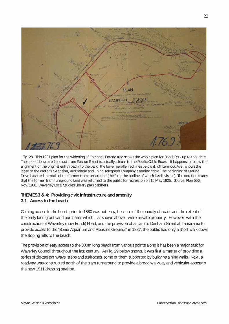
Mayne-Wilson & Associates Conservation Landscape Architects
Fig. 28 This 1931 plan for the widening of Campbell Parade also shows the whole plan for Bondi Park up to that date. The upper double red line out from Roscoe Street is actually a lease to the Pacific Cable Board. It happens to follow the alignment of the original entry road into the park. The lower parallel red lines below it, off Lamrock Ave., shows the lease to the eastern extension, Australasia and China Telegraph Company’s marine cable. The beginning of Marine Drive is dotted in south of the former tram turnaround (the faint the outline of which is still visible). The notation states that the former tram turnaround land was returned to the public for recreation on 15 May 1925. Source: Plan 556, Nov. 1931. Waverley Local Studies Library plan cabinets THEMES 3 & 4: Providing civic infrastructure and amenity 3.1 Access to the beach Gaining access to the beach prior to 1880 was not easy, because of the paucity of roads and the extent of the early land grants and purchases which – as shown above - were private property. However, with the construction of Waverley (now Bondi) Road, and the provision of a tram to Denham Street at Tamarama to provide access to the ‘Bondi Aquarium and Pleasure Grounds’ in 1887, the public had only a short walk down the sloping hills to the beach.
The provision of easy access to the 800m long beach from various points along it has been a major task for Waverley Council throughout the last century. As Fig. 29 below shows, it was first a matter of providing a series of zig-zag pathways, steps and staircases, some of them supported by bulky retaining walls. Next, a roadway was constructed north of the tram turnaround to provide a broad walkway and vehicular access to the new 1911 dressing pavilion.

24
Mayne-Wilson & Associates Conservation Landscape Architects
Fig. 29 This image c. 1905 shows clearly the zig-zag pathways, retaining walls, and sets of stairs down to the beach, with the tram waiting shed at the top right hand corner. Source: Star Photo Co. PXE 711 / 186
As the beach gained in popularity, plans for a major improvement program were drawn up between 1923 and 1927 and finally implemented in 1928. As motor cars became available and more affordable in the 1920s, the tram turnaround was moved to the north of Campbell Street (see Transport sub-theme below). The opportunity was taken to commence the access roadway, Marine Driveway, further south. This initially provided road access to the telegraph cable station, but its extension in a north-easterly direction was a response to increased pressures to have a motor driveway along the full length of the beach. This both provided easy car access (and parking just behind the beach) and/or the opportunity simply to drive along it and enjoy the sparkling view and people enjoying the surf. Marine Drive thus became an essential component of the overall park and the beach-going experience – a role it has played for over a century (even though its starting point was moved to the south after 1928.)
It is worth noting, for comparative purposes, that vehicular in-out access driveways to enable visitors to enjoy spectacular views out were incorporated into park design plans for Hornsby Park in 1927 and Coronation Viewpoint Park (St Leonards) in 1937, and were an integral part of their overall layout/design.
Early access to the southern baths was via a track that was a rough continuation of Sir Thomas Mitchell Road, across Bondi Road. Sands Directory indicates that there were five houses along the southern side of that track leading to the baths. By 1924 several blocks of flats and new residences appear alongside this unmade road, and it seems likely that the sandstone block retaining wall on the northern side of that road was built about this time. The size of the sandstone blocks and the style of construction are consistent with that assumption. The name Notts Avenue was not mentioned in Sands Directory; however, it appears in the 1931 plan (Fig. 28 above), and was marked in (by hand, later) in a 1943 aerial photograph.

25
Mayne-Wilson & Associates Conservation Landscape Architects
Fig. 30 Section of a panorama showing the access pathway down from Notts Avenue (at top right) to the promenade, c. 1970. Source: Waverley Council Library.
3.2 Public Transport
Public agitation in 1890 for a proper tramway service directly to the beach led to the provision of a regular tram service from Circular Quay to Bondi, beginning in October 1902. (The speed of the trams going down the last hill to the beach led to the common expression of ‘shooting through like a Bondi tram’.) Initially, a large turnaround for the trams - as shown in the images below - was provided east of Campbell Parade, on top of the hill, visible on the left of Figure 31 below.
Fig. 31 The tram turn-around on Campbell Parade (opposite Hall Street) in the 1920s. The initial entry to Marine Drive was to its north, arrowed. Source: Waverley Local Studies Library
Fig. 32 Undated photograph from c. early 1960s, showing the trams along the central-northern section of Campbell Parade. Source: Waverley Local Studies Library.

26
Mayne-Wilson & Associates Conservation Landscape Architects
3.3 Provision of amenities – change rooms, lavatories etc.
The opening of the tram service in October 1902, delivering thousands of people to the beach, prompted the Council to provide facilities for them. The first were simple dressing sheds, c. 1903.
Fig. 33 The simple dressing sheds toward the southern end of the beach, image c. 1905. Source: State Library of NSW, Call Number - PXE 711 / 185
Council then provided accommodation for the newly formed Bondi Surf Bathers Life Saving Club in 1907-08. Initially, accommodation for the Club was a canvas tent, then Council provided a weatherboard shed 20 x 30 feet, which it doubled in size in 1908. A kiosk was later added to the front of it. In 1916 a new club house was erected, but in a more central location.
Fig. 34 Roofed dressing shed, c. 1908-9, with first Bondi Surf Bathers Surf Life Saving Club at top right. Source: State Library of NSW, Call Number - PXE 711 / 183

27
Mayne-Wilson & Associates Conservation Landscape Architects
By 1909 Waverley Council was discussing an ambitious development program for the park and announced a design competition for new beach dressing sheds. The winning design was modified, but the first pavilion, known locally as ‘the castle’ because of its turrets, was erected in 1911, and is shown below.
Fig. 35 The 1911 dressing sheds/pavilion, on the edge of the promenade, supported by a sea wall. Source: Waverley Local Studies Library
Fig. 36 Crowds in front of the new 1911 Pavilion. Source: MA thesis by P. Quinn-Boas, original in Waverley Local Studies Library

28
Mayne-Wilson & Associates Conservation Landscape Architects
Fig. 37 This c. 1913 sketch by the Department of Public Works, titled Bondi Beach Improvement Plan, shows the earliest facilities. Below the 1902 tram turnaround loop are, from the left, the gents dressing shed, the ladies dressing shed, the original entry drive (with a blue metal road (dotted lines) peeling off it), the bandstand, and the Municipal
Surf Sheds. Although It also shows the Bondi Surf Bathers Life Saving shed (arrowed), the location of this is incorrect, as it was actually much further to the south (i.e. at left of this image, approximately at ‘X’ on the plan). The stone sea wall
and its proposed extension to it is also shown. Source: reproduced from CLS&P CMP, fig. 4.1.
A bandstand was also provided, and a somewhat monumental public lavatory and shower block. The latter was close to the first tram turnaround, as shown in Fig. 39 below.
Fig. 38 The bandstand, (c.1912) which was removed
in the 1920s. Source: State Library of NSW, Government Printing Office 1 - 17108.
Fig. 39 Toilet block (at centre), tram turnaround, the 1911 pavilion, and young Norfolk Island Pines - 1920. Source: Waverley local studies library. Panorama by EB Studios.

29
Mayne-Wilson & Associates Conservation Landscape Architects
Fig. 40 This 1923 Bondi Beach Improvement Plan shows the replacement of the early dressing sheds by the larger concrete one shown in Fig. 39, the continued presence of the bandstand, the disappearance of the blue metal road off the entry to Marine Drive, the completion of the sea wall, the relocation of the Surf Club (arrowed) to the north of the municipal surf shed (the ‘castle’), and the provision of a concrete ramp down from the promenade to the beach. Source: CLS& P, CMP Figure 4.2. Details of the finalisation and actual implementation of the improvement plan are provided later in this Report, but for easy comparative purposes, it is outlined in the sketch below.
Fig. 41 A 1929 sketch of the 1928 Improvement Plan, showing the revised formal entry to Marine Drive at far left, the removal of the tram turnaround loop (dashed lines), boldly axial paths, two pedestrian overpass bridges, the location of the Surf Club, and two groynes connecting the changing sheds directly to the beach. Source: CLS &P CMP Fig. 4.3. p. 89.

30
Mayne-Wilson & Associates Conservation Landscape Architects
3.4 Marine Drive and the Promenade As shown in Figure 29 above the first access tracks and paths generally followed the slope down to the beach, just north of the covered-over lagoon entry to the sea. An actual road, the precursor of Marine Drive, commenced a little to the north of the tram turnaround, just before the junction of Roscoe St with Campbell Parade – see Figure 31 above.
The first development scheme drawn up in 1909 and launched in 1911 included provision of an access road to the new dressing pavilion, several pathways, and the construction of a sea wall, along the inner side of which was a promenade.
Fig. 42 A R.P. Moore panorama, 1910s, looking north past the bandstand. The original entry road commenced north of the tram turnaround, near Roscoe Street. (The footslope of the tram turnaround is just visible at the bottom left of this
image.) Source: Waverley Council Library
Fig. 43 In the foreground the original access road to the old change sheds and beach is seen joining Marine Drive at right, c. 1912. Source: MA thesis by P. Quinn-Boas, original in Waverley Local Studies Library

31
Mayne-Wilson & Associates Conservation Landscape Architects
Fig. 44 The same view, a decade later, showing visitors walking down the original entry to Marine Drive in the early 1920s. Source: Waverley Local Studies Library.
Fig. 45 Marine Drive & Promenade in 1917. Source: NSW State Library, Gov’t Printing Office 1 – 18746

32
Mayne-Wilson & Associates Conservation Landscape Architects
Fig. 46 Part of an EB Studios 1920 panorama. This image shows the promenade is well established, and the 1911 pavilion (black arrow) and the toilet block (white arrow) are evident in the distance. The track in the foreground is likely to be that shown as a dashed line (at right) in Fig. 37 above: Source: State Library of NSW, SPF / 1179.
By 1920 the promenade was completed to the northern end of the beach, as shown below.
Fig. 47 The northern end of the promenade, with Marine Drive curving off to the right. Source: Waverley Library
The promenade became part of the key experience of visiting Bondi, with people enjoying the long walk while chatting and watching passersby.

33
Mayne-Wilson & Associates Conservation Landscape Architects
Fig. 48 People enjoying the promenade in 1934. Note Beach Court (with dance hall) 1920, arrowed, along Ramsgate Ave. at the north end of the beach. Source: State Library of NSW, Call Number Home and Away - 5208
Fig. 49 Side-walk cafes near the pavilion lent an air of sophistication to the promenade in the 1930s. Source: MA thesis by P. Quinn-Boas, original in Waverley Local Studies Library

34
Mayne-Wilson & Associates Conservation Landscape Architects
Fig. 50 Northern end of the promenade, Aug. 2012 Fig. 51 Murals on southern section of promenade, 2012
Other paths and tracks developed over time, but the most elaborate system was that devised in conjunction with the 1928 development scheme, as shown in the images below.
A highly conceptualised scheme from Robertson and Marks (1927/28), possibly inspired by City Beautiful
design concepts of 1890 – 1920.
Fig. 52 This sketch seemingly influenced their final design. Source: Waverley local studies library
Fig. 53 1931 Aerial view of the Improvement scheme shortly after completion. Source: Mitchell Library
Fig. 54 Another aerial view, also soon after completion .Source: MA thesis by P. Quinn-Boas, original in Waverley Local Studies Library

35
Mayne-Wilson & Associates Conservation Landscape Architects
3.5 Drainage and Sewerage
The matter of improving the unsavoury stormwater outlet for the original creeks and lagoon/s which ultimately drained across the beach into the ocean opposite Lamrock Avenue remained a continuing issue. The stormwater drainage problem was most acute at the southern end of the beach because this was the original lagoon drainage outlet. The images below show that this problem continued until the late 1980s, when the concrete drainage channel was laid along the rocky foreshore below Notts Avenue.
Fig. 55 Late 1928 aerial looking over Bondi Bay. The lagoon outlet is visible at left, and the tram turning circle has not yet been removed. Source: Waverley Local Studies Library
Fig. 56 The creek/stormwater drain is visible at top left in late 1928 Source: Waverley Local Studies Library (No. 6402)
Fig. 57 Drainage was still an issue in 1972. Source: Waverley Local Studies Library
Fig. 58 The concreted creek drainage outlet now at the far end of Bondi Park. Source: DSCA 2008
Fig. 59 The actual outlet is arrowed, not far from the Iceberg’s Pool. Note the plume of weed that has
developed offshore. Source: Google maps Simple toilet blocks were provided early on at the southern end of the beach, as it was the first point of arrival for people on the trams coming down Bondi Road. Council Minutes reveal that the proper disposal of

36
Mayne-Wilson & Associates Conservation Landscape Architects
sewage from the lavatories on the sandhills just behind the beach from 1903 onwards was a matter of increasing concern, with pressure for them to be connected to the municipal sewer line. The historical images reveal a continual replacement and multiplication of toilet blocks throughout the decades.
Fig. 60 Shower and toilet block, built soon after 1911.
(See also Fig. 39 above) Source: Waverley Council Library, (No. 165 Maps C4)
Fig. 61 The North Bondi toilet block in 1968 close to the North Bondi Surf Life Saving Club (bottom of image). Source: National Archives of Australia,
Image no. : B941, SURFING AND BEACHES/1
Among the improvements listed in Council’s application to the State Government for funding in May 1927 were public conveniences in the northern end of the promenade. These were ultimately provided in accordance with the plan shown below.
Fig. 62 Plan for the provision of toilet block and pumping station for the northern end of the beach.
In more recent times a new toilet block was provided at the foot of the stairs linking the Park’s promenade walkway to Notts Avenue. This was designed by Ian Stapleton of Clive Lucas Stapleton & Partners in 1983, and was built soon afterwards. Stylistically it adopts the arched façade of the main pavilion, and is painted the same colour. Its flat roof provides a good lookout platform from which to enjoy the view of the beach.

37
Mayne-Wilson & Associates Conservation Landscape Architects
Fig. 63 The 1984 toilet block beside the staircase to Notts Avenue, designed by Ian Stapleton of CLS&P in 1983 to match the style of the pavilion. Photo: MWA 2012
THEMES: 3.11 Altering the environment – planning better landscapes; 8.5.4 Developing public parks and gardens
The landscaping of Bondi Park has been a work in progress ever since the first Norfolk Island Pines were planted in the south-west corner in 1894. The early works were in stabilising the sandhills and creating slopes that were less steep. Sandstone block walls and zigzag paths were constructed down the steep southern slopes as shown in the image below.
Fig. 64 The sandstone block retaining walls c.1910s down the southern slopes of the park. Source: National Library of Australia, pic-vn3673837-v

38
Mayne-Wilson & Associates Conservation Landscape Architects
The other pathways were created subsequently, as part of the 1911 improvements. The alignments of some have been changed, a few removed, and others substituted. However, the major ones present today are mainly the survivors of the 1928 improvement scheme. The Bondi Park Improvement Schemes Council undertook several improvement schemes, the first occurring in 1910-11. As the beach’s popularity and visitation numbers increased, calls for further improvements were made in late 1914. An expanded scheme proposed the extension of the sea wall north to Ben Buckler, and the construction of a marine drive 50 feet wide which would include a new tramway with a pedestrian reserve on the seaward side 15 feet wide. There was to be a tree reserve of similar width on the leeward side behind this wall, increased accommodation for the male and female changing rooms, and a new clubhouse for the Bondi and North Bondi Surf Life Saving Clubs. 3 Architects Robertson and Marks prepared a scheme, but it was eventually shelved because of the cost. In any case, World War I erupted, which diverted attention and resources. With the increased purchase of motor cars by the average person during the 1920s, and the ready availability of public transport (trams and now buses) to the beach, the fabric of Bondi Park became increasingly worn. The original buildings were never very robust, and between heavy public use and normal seasonal storms, they and the park landscaping generally began to look very tired. In fact, the place was being ‘loved to death’. In response, with World War I behind them, Council began to embark upon schemes of improvement from 1923 onwards, with work being done in stages, including on pathways and tree plantings. In 1924 a competition was called for the design of a new, much larger pavilion, to accommodate changing 750 cubicles for men and 250 for women. Other beach and park improvements were to include:
A kiosk and surf shed with at least 50% increased accommodation and allow for future extensions The elimination of cross traffic over the Marine Drive and Promenade Increased pedestrian and vehicular traffic capacity Three lavatory blocks with separate accommodation for males and females A band stand; and The layout of the park surrounding the proposed buildings.
A jury announced the winning design in March 1924, but again the costs involved were beyond the Council’s means. The Clive Lucas, Stapleton & Partners’ Report Conservation Analysis and Conservation Guidelines of 1997 provide details of the negotiations that occurred over the following two years, with the scaling down of the scheme because of costs. Architects Robertson & Marks were requested to prepare a new scheme, which they duly did. This was submitted to Council in June 1926, and was approved. The Minister for Local Government then subjected it to an inquiry led by Commissioner C. W. Jenkins. The Commissioner recommended quite a number of improvements, which Robertson & Marks incorporated into the revised scheme. They also suggested that two concrete groynes adjacent to the pavilion and a series of smaller groynes along the sea front should be built to alleviate the sand drift problem. The Inquiry accepted the revised scheme, except for the smaller groynes.4 A Council Notice on the project was published in the Sydney Morning Herald on 4 December 1926 spelling out the details – see Appendix B.
3 Clive Lucas Stapleton & Partners, 1997. Bondi Pavilion, Surf Club and Surrounds, Conservation Analysis and Guidelines, p.69 4 ibid
39
Mayne-Wilson & Associates Conservation Landscape Architects
The Sydney Morning Herald reported on 6 July 1927 the ‘Progressive Bondi Improvement Scheme’, that
“ . . . fronting the pavilion will be a marine drive extending from Bondi road, at its Junction with Lamrock Avenue, to Campbell Parade, [and proceed to] the northern end of the beach approximately 800 yards in length and 50 feet in width, constructed of unreinforced concrete.
Access to the marine drive through the gardens will be by means of three bridges, and the motor park will be approached by an easy ramp from Campbell Parade, both at the northern and southern extremities. About three feet below the drive there will be a promenade about 30 feet in width. This promenade will be reached by three subways. In addition, refuges will be provided in the centre of the drive for pedestrians wishing to cross the road and gain access to the promenade . . . The park will be laid out picturesquely . . . .”
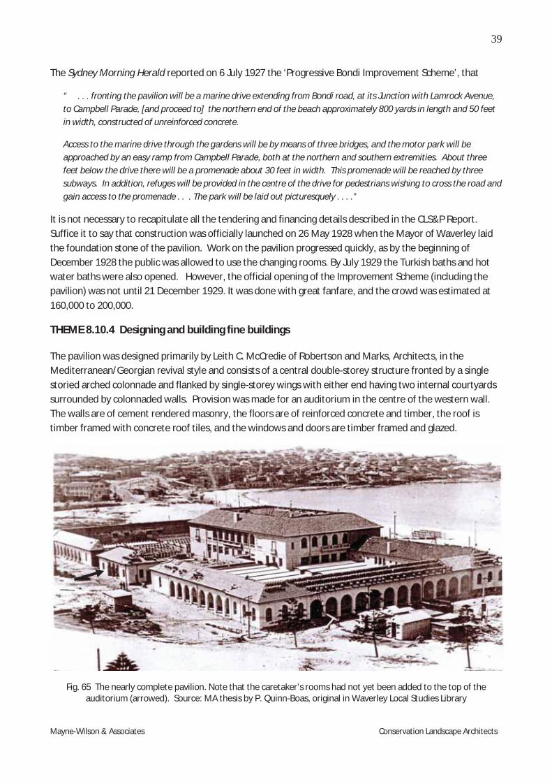
It is not necessary to recapitulate all the tendering and financing details described in the CLS&P Report. Suffice it to say that construction was officially launched on 26 May 1928 when the Mayor of Waverley laid the foundation stone of the pavilion. Work on the pavilion progressed quickly, as by the beginning of December 1928 the public was allowed to use the changing rooms. By July 1929 the Turkish baths and hot water baths were also opened. However, the official opening of the Improvement Scheme (including the pavilion) was not until 21 December 1929. It was done with great fanfare, and the crowd was estimated at 160,000 to 200,000.
THEME 8.10.4 Designing and building fine buildings The pavilion was designed primarily by Leith C. McCredie of Robertson and Marks, Architects, in the Mediterranean/Georgian revival style and consists of a central double-storey structure fronted by a single storied arched colonnade and flanked by single-storey wings with either end having two internal courtyards surrounded by colonnaded walls. Provision was made for an auditorium in the centre of the western wall. The walls are of cement rendered masonry, the floors are of reinforced concrete and timber, the roof is timber framed with concrete roof tiles, and the windows and doors are timber framed and glazed.
Fig. 65 The nearly complete pavilion. Note that the caretaker’s rooms had not yet been added to the top of the auditorium (arrowed). Source: MA thesis by P. Quinn-Boas, original in Waverley Local Studies Library

40
Mayne-Wilson & Associates Conservation Landscape Architects
Fig. 66 The new entry to Marine Drive in 1929, at the time the improvement scheme has just been declared open. Source: State Library of NSW, SPF / 3103.
Fig. 67 A Hurley aerial view of Bondi-Beach, soon after implementation of the improvement schemes. Note the strongly axial pathways leading to the overhead pedestrian bridges and pavilion, the prominent groynes and the multiple tree plantings. The small item, arrowed, may be a cable station. Source: 1930-1931-Mitchell-Library-e1323120299156

41
Mayne-Wilson & Associates Conservation Landscape Architects
The CLS&P summary of all the changes to the Park, Pavilion and Surf Club is shown in the sketch below
Fig. 68 CLS&P’s summary of all the previous features of the Park.

42
Mayne-Wilson & Associates Conservation Landscape Architects
The internal floor plan of the new pavilion itself is shown below.
Fig. 69 This plan shows the internal layout of the pavilion, replete with changing cabins.( However, the Turkish baths at the southern ground floor were removed in 1977 and the area let to the Bondi Boys Club.) Source: Waverley Library
Fig. 70 An earlier version of the pavilion by Robertson & Marks, Architects, which was not accepted. Waverley Library

43
Mayne-Wilson & Associates Conservation Landscape Architects
One of the features of the new pavilion was an auditorium, located at the rear of the pavilion, with the rising slope of the land up to Campbell Parade providing a natural amphitheatre. A plan for its design is shown below. Above the auditorium provision was made for a small caretaker’s residence, making the structure two storied in all.
Fig. 71 Robertson & Marks’ design for the auditorium. Source: CLS&P CMP 1997
Fig. 72 The temporary seating arrangements for concerts at the auditorium at the rear of the pavilion. Source: State Library of NSW, ‘At Work and Play’ - 00267
Fig. 73 A band entertaining an audience seated on deck chairs and facing downslope to the auditorium. The structure at the rear was a temporary one of timber and hessian. Source: Waverley Local Studies Library
In the mid 1940s a projection booth contain containing a projection room, power room and screen (in front of the western façade of the caretakers building) was installed in the auditorium, providing a temporary outdoor cinema. This, however, did not last long. The lease of the auditorium was later taken over by Ken

44
Mayne-Wilson & Associates Conservation Landscape Architects
Noyle, an entrepreneur from Durban, South Africa, who proposed to stage plays and vaudeville shows over the summer of 1957-58. The auditorium was also used on Sunday nights for free band concerts.5
Fig. 74 A popular band concert at the auditorium (undated). Source: MA thesis by P. Quinn-Boas, original in Waverley Local Studies Library
One of the several elements removed from the park were the tram turnaround, and relocation of the cable station of the Eastern Extension and Pacific Cable Companies. The cable was laid under (or just alongside) the original entry roadway (just south of Roscoe St.), which became the main pedestrian pathway into the park. The cable station building visible in the Hurley 1930 aerial photograph (Fig. 67) presumably went underground, as there appears to be no above-ground evidence today. The presence of this cable, and that of the other telegraph company (see Figure 28) is marked in orange in the 1943 aerial photograph below.
Fig. 75 A 1943 aerial view of the Park, with arrows pointing to the cable lines. Source: SIX Viewer. Dept of Lands 5 SMH 12 August, 1957, quoted in Lucas, op. cit.

45
Mayne-Wilson & Associates Conservation Landscape Architects
For the next decade Bondi Park looked very handsome, as the images below testify.
Fig. 76 View from the south, down Marine Drive, late 1930s: Source: MA thesis by P. Quinn-Boas, original in Waverley Local Studies Library
Fig. 77 - A 1930s photograph looking north across Bondi Park, showing the growing maturation of the Norfolk Island Pines dotted throughout the park (planted c.1930).
Source: State Records NSW (Digital ID:12932_a012_a012X2449000013.jpg

46
Mayne-Wilson & Associates Conservation Landscape Architects
Fig. 78 A 1930s photograph looking south across Bondi Park, showing the Norfolk Island Pines (planted c.1930) to the north of the pavilion and Bondi SBLSC. Source: State Records NSW (Digital ID:12932_a012_a012X2449000004.jpg)
Fig. 79 1930s View looking south from the North Bondi SLC building. Source: State Records, digital ID 12932_a012_012X24490000011.jpg

47
Mayne-Wilson & Associates Conservation Landscape Architects
Fig. 80 A 1929 view to the new pavilion from the former southern beach groyne. Source: Waverley Library
Fig. 81 Cover of a tourist promotional booklet on Bondi, April 1933 published by Waverley Council. Source: WLSL
Fig. 82 The pavilion thirty years on, retaining its original shape. Source: Dowd, B.T. History of Waverley Municipality.

48
Mayne-Wilson & Associates Conservation Landscape Architects
The pavilion was unlicensed, however, and to gain it after World War II ended, Council had to make alterations to the building such as two additional exits and stairways, emergency exit lights, additional lavatories, fire fighting equipment and ventilation in the ballroom. These took time in the austerity period immediately after the War, but were completed by 1948, when a licence was finally granted.
Landscaping and plantings During the 1950s the landscaping area around the pavilion gradually ran down, and the place looked worn. Most of the Norfolk Island plantings died, and were not replaced. The saga of these Pines is a sorry one:
Fig. 83 The Norfolk Island Pines behind the pavilion in 1967. These plantings were made as part of the 1930 mass plantings in the park. Note their poor condition at this time. Source: Waverley Local Studies Library (001251)
The main phases and locations of Norfolk Island Pine plantings within and abutting Bondi Park were
c. late 1800s A large grouping of Norfolks was planted at the southern tip of the main section of Bondi Park (where Queen Elizabeth Drive begins). One specimen from this time remains.
c. 1910s A double row of Norfolks was planted along the entire former edge of Bondi Park and Campbell Parade. One complete row (plus some others) were removed during the 1920s expansion of Campbell Parade. Most of the retained specimens either died off or were removed by 1930. A short row of these specimens (near the corner of Campbell Parade and Beach Road) remained in place until c.mid 1960s.
Some Norfolk Island Pines were also planted around this time through the southern slopes of the park - with some positioned directly behind the far southern end of the promenade. The location of specimens throughout the southern slopes (at that time) appears to have been carried out without a specific plan for the siting of the trees. Two specimens appear to remain from that time.
1930 An en-mass Norfolk Island Pine planting was carried out through the main section of the park (immediately south of the pavilion), on the slopes behind the pavilion and within the lawns to the immediate north of the Bondi SLSC. These plantings were part of the late 1920s improvement scheme works. Many of these trees had died by the mid to late 1960s.
A collection of images showing the plantings and their continuing failure is contained in Appendix A.

49
Mayne-Wilson & Associates Conservation Landscape Architects
Children’s playgrounds Childrens playgrounds have also been provided in various locations at different periods. One was provided where the present-day skate board park is located.
Fig. 84 Photograph by Frank Hurley of the main section of Bondi Park c. late 1930s, showing the many Norfolk Island Pines planted c.1930 as part of the beach and park improvement scheme works.
Note the small children’s playground, arrowed. Source: National Library of Australia (nla.pic-an23478450)
Another playground was later added to the north of the Bondi Surf Bathers Life Saving Club, in much the same location as the current one. Yet another was provided to the south of the main pavilion.
Fig. 85 Aerial photo from the 1960s showing the various children's play features to the north of the Bondi SBLSC, where the current large playground facility is located. Source: Waverley Council Library (no. 271)

50
Mayne-Wilson & Associates Conservation Landscape Architects
Fig. 86 Note the children’s playground in front of the southern façade of the pavilion, but the absence of Pines. This was the period where there was much community angst at the run-down state of the park. Source: Waverley Local Studies Library (No. 1704)
A hurdy-gurdy was installed to the south of the main pavilion for a short time, in the location where the crescent-shaped pergola is located today
Fig. 87 An early phase (1973) of the children's playground
off the southern face of the pavilion. Source: Waverley Local Studies Library (No. 609)
Fig. 88 The same site today is occupied by the curved pergola structure shown above. MWA 2012
Initially, Council operated some of the facilities at the pavilion, but these were later leased to private entrepreneurs – e.g. the Turkish bath facilities, the retail facilities on the ground floor, and the first floor spaces which included two halls. One sub-lessee was Roy Starfield, whose rooms were promoted as being a

51
Mayne-Wilson & Associates Conservation Landscape Architects
place for dining and the supply of food, but it was the dancing there that was apparently the main attraction.9 Council facilitated public band performances – for example, 50 band recitals were approved in 1932-33. More details of the facilities and entertainments in the pavilion are set out in Appendix B.
Provision was also made for elderly people (mostly men), through the supply of concrete benches and tables, some with chess boards on them, within the archways of the western façade of the building.
Fig. 89 The tables are still in use today. Photo MWA August 2012
Even a band rotunda was planned for the beach, but although drawings were prepared, it was not adopted.
Fig. 90 Plans for the proposed rotunda on the beach c. 1933. Source: Waverley Local Studies Library.
9 Lucas, op.cit

52
Mayne-Wilson & Associates Conservation Landscape Architects
THEME: 7.7.2 Preparing to face invasion.
Like all the coastal beaches along NSW – at least, north of Port Hacking – barbed wire and in some cases anti-tank landing traps were established in 1942 following Japan’s entry into World War II and the brief shelling of Sydney by their midget submarines. A complex system of barbed wire was spread along Bondi beach – as shown below.
Fig. 91 Soldiers installing the barbed wire fencing. Source: Waverley Library
Fig. 92 The barbed wire fencing in place, late 1942. It was known locally as ‘the rat run’. Source: Waverley Library
The military authorities also ordered that the two groynes on the beach that allowed direct entry into the pavilion be blown up, to prevent Japanese military forces gaining entry to Bondi that way.
Fig. 93 1930s aerial view over Bondi showing the two sand groynes before they were blown up in 1942 on the orders of the military. Source: State Library of NSW (Call Number, Government Printing Office 1 - 07361)

53
Mayne-Wilson & Associates Conservation Landscape Architects
The army engineers over-estimated the amount of explosives required, so that the force of the explosion shattered windows and broke tiles of the pavilion, surf clubs and some buildings along Campbell Parade.
Fig. 94 1943 aerial showing that the groynes had been removed. Source SIX Viewer © Lands Department.
The image below shows tilers replacing the original Cordoba-style tiles on the pavilion with concrete tiles following the explosion.
Fig. 95 Re-tiling the roof of the pavilion, after damaged caused by blowing up the concrete groynes.
Despite the fencing many people still went to the beach – a mass rescue took place in October 1942. The pavilion was occupied initially by the Volunteer Defence Corps and was designated the Bondi Beach Club. It served afternoon teas and held dances which catered to enlisted me. After the United States entered the Pacific War, Sydney was inundated with American Servicemen, and Bondi quickly became a popular place for their rest and recreation. To facilitate their enjoyment, US forces via the American Red Cross took over a floor of the pavilion in 1944 and the old Esplanade Cabaret became a private military club.

54
Mayne-Wilson & Associates Conservation Landscape Architects
Following the end of World War II, the first floor of the pavilion continued in its pre-war modes with Roy Starfields’ cabarets.10 However, as the pavilion was unlicensed, the Council had to make certain alterations to the building such as two additional exits and stairways, emergency exit lights, additional lavatories, fire fighting equipment and ventilation in the ballroom. These took time in the austerity period immediately after the War, but were completed by 1948, when a licence was finally granted.
THEME 8.5 Provision of institutions to support social activities
The mid 1970s Improvement Scheme – Conversion of the Pavilion to Waverley Cultural Centre
By the mid 1960s, however, the park and pavilion were run down and needed refurbishment and upgrading, as the image below shows.
Fig. 96 A 1972 aerial. Note how barren the park appears. The creek/stormwater outlet (arrowed) is still visible even then. Source: Waverley Local Studies Library
Various schemes were considered – as described in the CLS&P CMP, but were eventually rejected. Instead, the internal courtyards underwent major changes in the 1960s to 1980s. The dressing cubicles and lockers were removed, and the internal courtyards became somewhat vacant spaces.
10 Lucas, op. cit

55
Mayne-Wilson & Associates Conservation Landscape Architects
Fig. 97 Undated photograph (c.1973) of the pavilion
courtyard dressing sheds. Waverley Local Studies Library (Maps A-2, No. 312).
Fig. 98 The same northern courtyard in 1979, after removal of the dressing sheds. Source: Waverley Local
Studies Library
In 1968 some walls were rebuilt for structural reasons, and in the early 1970s major internal changes were made. The former ballroom was converted to a theatre in 1972-75, while in 1977-78 the change rooms, lockers, and former Turkish baths were removed. The internal courtyards were replaced by large, grassed areas, a netball court and a tiered brick amphitheatre. Note that the latter was now within the pavilion footprint, so that the audience was no longer seated downslope, facing the external wall of the building.
In 1975, the Surf Pavilion was formally converted into the Waverley Community Cultural Centre. Following from the involvement of the local community to complete an indoor theatre, regular performances were held there; this later became a professional body attracting government funding. The Tamarama Rock Surfers (a theatre company formed in 1997) has continued the use of the theatre for live productions. Provision was also made for workshops for craft classes, a child care centre, two gymnasiums, several meeting rooms, a seafood restaurant, change rooms and toilets.
The use of the pavilion as a cultural centre is important to the local community as it also provides other live music and performances, an annual film festival, and art gallery with regular exhibitions. Other groups also visit the Pavilion for playing cards, chess, eating at the restaurants and cafes and other social meetings. This gives the Pavilion and surrounding park additional status as a valued place to meet for leisure pursuits not just for surf and beach related activities. In keeping with the emphasis on creative arts, the courtyard walls were painted in the early 1980s with murals depicting heroic lifesavers and various episodes of the history of Bondi along the theme of Bondi the Beautiful, but these eventually faded and were simply painted over. Ceramic murals and enlarged historical photographs were installed on walls in the foyer in 1985. More recent changes have included the construction of a new forecourt, and a glazed semi-circular structure to the north-east corner to the pavilion to house a seafood restaurant. Some changes were also made to the Bondi Surf Bathers Life Saving clubs building. A summary of all these can be read at the back of this report. The images below show the current features of the pavilion. Most images are by MWA, August 2012

56
Mayne-Wilson & Associates Conservation Landscape Architects
Fig. 99 Pathway leading down to the rear of the pavilion. The caretaker was originally housed in the upper storey.
Fig. 100 The recent auditorium seating, this time within the courtyard, facing the east side of the caretaker’s quarters
Fig. 101 1981 photo of part of the mural on the inside of the pavilion's northern courtyard painted by Rodney Monks Source: State Library of NSW (Call number, G P O 3 - 18313)
Fig. 102 The now under-used northern courtyard, with a recent structure attached to its eastern side.
Fig. 103 The southern internal courtyard, apparently no longer used for netball or basketball, but for car parking.
Fig. 104 Mosaics and copies of old photographs on the walls of the entry foyer of the pavilion, installed in 1985. Image: MWA 2012

57
Mayne-Wilson & Associates Conservation Landscape Architects
THEME: 8.5.2 Forming Associations & Supporting Development of Local Clubs
Waverley Council gave a great deal of support and encouragement to the establishment of the two surf life saving clubs at Bondi beach, which is well described in Dr Sean Brawley’s book The Bondi Livesaver: Surf Rescue (ABC Books, 1907) and in Bruce Elder’s book Ready, Aye, Ready A Century of Life Saving (North Bondi Surf Life Saving Club, 2006.) Brawley’s book deals essentially with the Bondi Surf Bathers Life Saving Club (1906-07), while Elder’s recounts the story of the North Bondi Life Saving Club. Reasons for the existence of two clubs and the rivalry between them are explained therein.
The first Bondi Surf Bathers Life Saving Club (BSBLSC), located at the southern end of the beach began as a tent in 1907, but with some financial help from Council was soon upgraded into a shed, to which a kiosk was attached on the front – see Figure 105 below. After the new dressing pavilion, ‘the castle’, was built in 1911, a much larger, replacement building was erected, to the north of it. This was a more central location, and as Bruce Elder wrote: “with the trams now disgorging visitors to the beach near Curlewis Street, the vast majority of bathers made their way to the pavilion, the dressing sheds and the [BSB] Life Saving Club."12
Fig. 105 The first Bondi Surf Bathers Life Saving Club, c. 1908, just upslope, to the south, from the lagoon
outlet. Source: State Library Home and Away -35104.
Fig. 106 Part of 1922 panorama showing the Bondi Surf Bathers Life Saving Club house, built in 1916 to the north of the 1911 ‘castle’ pavilion, Source: Waverley Library.
The 1916 BSBLSC building lasted for about 5 years after the new colonnaded pavilion was erected in 1928-9. However, many felt it was too old fashioned, being virtually cheek by jowl against the new pavilion. Accordingly, it was demolished, and a new Clubhouse more in keeping with the pavilion was erected in 1934.
Fig. 107 The 1916 club beside the new pavilion. Fig. 108 The new club building. Source: P Q-B Thesis.
12 Elder, B. 2006 Ready Aye Ready – A Century of North Bondi Surf Life Saving Club, 1906-2006. Published by the Club.

58
Mayne-Wilson & Associates Conservation Landscape Architects
Fig. 109 The present Bondi Surf Bathers Life Saving Club,
after having been extended since 1934. Photo MWA 2012 Fig. 110 The formal front entrance. Photo: MWA 2012
Fig. 111 Plan of the new club house for the Bondi Surf Bathers Life Saving Club, designed in 1933 by H.S. Ross and Rowe, architects and built in 1934, partly using Unemployment Relief Funds. Source: Waverley Council’s Engineer’s
Office, Index No. 432619

59
Mayne-Wilson & Associates Conservation Landscape Architects
Meanwhile, sandhills at the northern end of the beach, furthest from public transport, had long attracted lively young men, some of whom would camp at weekends on the sandhill where Biddigal Reserve is now developed. In addition to surfing, they liked ‘larking about’ and their founding of a club in 1907 was initially as much for social and ‘bonding’ reasons as for life saving. Their first ‘clubhouse’ was established in a tent, as shown in the image below. A little later a simple shed was built adjacent to the home of the Club Captain, Wally Weekes, who owned land at the northern end of the beach, which at that time had not been incorporated into Bondi Park.
Fig. 112 The tent on the slope of the sandhill at far left was the first home in 1907 of what became the North Bondi Surf Life Saving Club. Image purchased by Waverley Library from the NBSLSC in June 1987. No. 4384
Elder pointed out that Waverley Council did not consider it necessary to have a second Surf Life Saving Club at the beach, so did not support calls for another club building to be provided at the northern end. However, after World War I was over, funds were raised and permission given for a new North Bondi Surf Life Saving Club to be built in 1920 – see below - on land still owned by the Club Captain, Wally Weekes. below
Fig. 113 The North Bondi Surf Life Savers Building in 1920. Source: State Library of NSW, SPF / 1179.
Fig. 114 The same Club building, with members, from the front. Source: Waverley local studies library.

60
Mayne-Wilson & Associates Conservation Landscape Architects
Fig. 115 The North Bondi Surf Life Saving Club that replaced the 1920 building shown above. Source: Bruce Elder’s book Ready Aye Ready
Fig. 116 The NBSLC building seen from the air in 2009, with public toilets and gymnasium on the left. Source:
Google Earth
Fig. 117 Pathway to the existing toilet block (designed to match the style of the now demolished NBSLC building –
see site at right. Photo: MWA 2012
Fig. 118 The outdoor gymnasium area, viewed from the south, with toilet block at far left. Photo: MWA 2012
Fig. 119 A 1940 photo looking north along Bondi Beach during a surf club parade. Source: State Library of NSW, Call number, Home and Away – 20265

61
Mayne-Wilson & Associates Conservation Landscape Architects
Fig. 120The Queen viewing the Royal Command Surf Carnival at
Bondi beach in 1954
Fig. 121 Image from Dowd’s History of Waverley Municipality
THEME: 8.5.4 Pursuing Common Leisure Pursuits
Over the decades, Bondi beach and park have been used to host many events, including the starting and finishing points for motor car rallies (e.g. Ampol and Mobilgas Trials), a cycling display by Hubert Opperman (c. 1936), countless surf and swimming races and carnivals, the Festival of the Winds, and the finishing line for the City-to-Surf race each August. Other events have included a Red Indian Wild West Show, Mexican Cowboys and annual celebrations of Christmas Day. Perhaps the biggest event and disturbance to the beach was the holding of the Olympic beach volley ball competition in the year 2000, where an elaborate stand was erected for this purpose. Some of these events are depicted in the images below.
Fig. 122 The Volleyball Olympics at Bondi, 2000. Source
National Library an 23302509-v Fig. 123 Winner of City-to-Surf, 1976, Byron Campbell.
Source Australian Photographic Agency - 39738

62
Mayne-Wilson & Associates Conservation Landscape Architects
Fig. 124 Hubert Opperman at Bondi, c.1936. Source: Hood Collection. Home & Away – 13145 State Library NSW
Fig. 125 Christmas at Bondi. Jon Lewis. Source NLA pic-an24797954-v
Fig. 126 Winner of Ampol Trial, 1964. Source: Australian Photographic Agency, 16914
Fig. 127 Bondi Beach girl and her pet poodle. 1962 Source: McQuilllan, EM. Nla.pic vn3308227
Figs 128 & 129 Kites flying during the Festival of the Winds Source : Waverley Council Website 2012.

63
Mayne-Wilson & Associates Conservation Landscape Architects
3.0 HERITAGE SIGNIFICANCE
Recognition of the Park as a Heritage Place The preamble to the Burra Charter summarises the value of heritage places to the community, as follows:
“places of cultural significance enrich people’s lives, often providing a deep and inspirational sense of connection to community and landscape, to the past and to lived experiences. They are historical records, that are important as tangible expressions of Australian identity and experience. . . . They tell us about who we are and the past that has formed us and the Australian landscape. They are irreplaceable and precious . . . and must be conserved for present and future generations.”
Purpose and scope of a Statement of Significance In the Burra Charter, cultural significance is defined as follows:
Cultural significance means aesthetic, historic, scientific, social or spiritual value for past, present or future generations. Cultural significance is embodied in the place itself, its fabric, setting, use, associations, meanings, records, related places and related objects.
Places may have a range of values for different individuals or groups. Understanding significance is crucial to the care of a place of cultural significance. It provides the basis for the development of policy for managing the place, and is reliant upon a thorough understanding of the place itself and what contributes to its significance.
A statement of significance is a formal method used to describe the qualities that make a place important to the community as a whole. The preparation of statement of significance is an accepted method, used by professionals and organisations involved with heritage, to convey the importance of a place. A secondary role is to communicate to people unfamiliar with the place’s importance and to promote clear thinking and a framework for action among those responsible for its conservation.
Assessing Significance The significance of the Park is discussed in relation to the criteria adopted by the NSW Heritage Office and set out in its guidelines document Assessing Heritage Significance 2001. These have been used in the following assessment, and its criteria are set out below:16
NSW Heritage Office criteria for assessment of significance
Criterion (a): importance in the course, or pattern, of NSW's or the local area’s cultural or natural history; Criterion (b): strong or special association with the life or works of a person, or group of persons, of
importance in the cultural or natural history of NSW or the local area; Criterion (c): importance in demonstrating aesthetic characteristics and/or a high degree of creative or
technical achievement in NSW or the local area; Criterion (d): strong or special association with a particular community or cultural group in NSW or the
local area for social, cultural or spiritual reasons; Criterion (e): potential to yield information that will contribute to an understanding of NSW's or the local
area’s cultural or natural history;
16 NSW Heritage Assessment Criteria, as adopted from April 1999
64
Mayne-Wilson & Associates Conservation Landscape Architects
Criterion (f): possession of uncommon, rare or endangered aspects of the cultural or natural history of NSW or the local area;
Criterion (g): importance in demonstrating the principal characteristics of a class of NSW’s or the local area’s cultural or natural places or environments.
To be assessed as having heritage significance, an item or place must:
o meet at least one or more of the nature of significance criteria [criteria a, b, c, and d]; and o retain the integrity of its key attributes.
An item or place may also be ranked according to their heritage significance as having:
o Local Significance o State Significance
Assessment according to NSW heritage criteria
Criterion (a): importance in the course, or pattern, of NSW's or the local area’s cultural or natural history; Bondi Park evolved into a major cultural landscape through modification of the sandhills behind the remarkably long curving beach and bay with its gently shelving sands and rolling waves suitable for surfing. It attracted the public from the mid 1800s and a range of facilities were provided to meet their needs. Land subdivisions commenced behind the beach in the late 1870s, with the beach and sandhills declared a reserve for public recreation in 1882. Access to the beach was facilitated by the construction of Bondi Road (initially Waverley Road) and Campbell Parade and by a regular tram service in 1902. Accommodation, shops and food outlets along Campbell Parade provided supporting infrastructure. Waverley Council developed swimming baths at the southern end, and subsequently provided dressing sheds, lavatories and support for the Bondi Surf Bathers Life Saving Club in 1907. This was rebuilt in 1916 to the north of the new turreted 1911 pavilion and again in 1934 after the present pavilion was constructed. A marine drive, sea wall and promenade were also commenced in 1911. The major improvement scheme of the late 1920s created the now iconic Surf Bathers Pavilion, together with an impressive pathway system, marine drive with provision for extensive vehicular parking, a broad promenade, tree plantings, pedestrian overpasses, and underground groynes to enable bathers, after changing, to access the beach directly. The decade 1926 – 1936 was the high point of the Park and Pavilion’s development, and its facilities, combined with the excellent beach and surf, made it a world famous beach destination. Those facilities have been retained, with some upgrading, ever since, and the park, pavilion, beach and general setting combine to create a cultural landscape of exceptional importance. Bondi beach has been a magnet for visitors since the 1850s, with the numbers continuing to grow as it became an iconic Australian surf beach, with a wide range of events being held on the beach and park area. Criterion (b): strong or special association with the life or works of a person, or group of persons, of importance in the cultural
or natural history of NSW or the local area; No one individual is directly associated with the creation of this historic cultural landscape, although the land owner of the southern sector of the beach, Francis O’Brien, did make it available to the public between 1855 and 1877. The beach improvement schemes were devised and driven by Waverley Council, who also gave support and encouragement to the two Surf Life Saving Clubs from 1907 onwards. The southern baths remained under Crown Land ownership and were entrusted to the Icebergs Club in 1959, although remaining part of the Bondi Beach-going experience.

65
Mayne-Wilson & Associates Conservation Landscape Architects
Criterion (c): importance in demonstrating aesthetic characteristics and/or a high degree of creative or technical achievement in NSW or the local area; The Park and pavilion are important for demonstrating the sensible but gradual adaptation of unstable and irregular sandhills into a public park. Many persons had an involvement in its layout but the most important were the architectural firm of Robinson & Marks, who designed the pavilion and Bondi Surf Bathers Life Saving Club, taking into account many suggestions from a commission of inquiry in 1927. The pavilion and its associated facilities are admirably designed in a simplified Mediterranean stripped classical style that suit the natural conditions as well as bathers’ needs. The pavilion has served its initial purposes well, and has been able to be adapted into the Waverley Cultural Centre in recent decades while still serving bathers needs. Criterion (d): strong or special association with a particular community or cultural group in NSW or the local area for social, cultural or spiritual reasons; The Park has a strong and special association with two Surf Life Saving Clubs, who share the credit for establishing an important service for saving the lives of many inexperienced bathers and for promoting that service into a national and later international Surf Life Saving Movement. Bondi Beach has been the site of many cultural events and festivals, including the holding of the Olympic Beach Volleyball competition in 2000 and the annual Festival of the Winds. It has and continues to be the destination of many rallies and sporting events including car rallies and the City to Surf running marathon. Criterion (e): potential to yield information that will contribute to an understanding of NSW's or the local area’s cultural or natural history; Prior to European settlement, there were no structures on or near the beach, the only elements present were Aboriginal middens and tools. Carvings were made in the rocks of the headlands to the north and south of the park, but not within the park itself. However, the beach and sandhills have been so extensively modified over the last 130 years that – with the exception of the Scarborough sandhill - it is doubtful that they have potential to yield archaeological information of any significance. With regard to Aboriginal relics, it is possible there is the remains of an Aboriginal midden beneath what is now Queen Elizabeth Drive or relics below the surface of Scarborough sandhill however, no such elements have been found for over a century. Criterion (f): possession of uncommon, rare or endangered aspects of the cultural or natural history of NSW or the local area; Bondi Bay, along which the park has been laid out, is uncommon in that it faces south-east, while most other bays and beach face eastward. The unusual length of the beach, the distance to which it extends inland, the quantity and quality of its sand, the amphitheatre-like shape of its sandhills, and its gently shelving ocean floor that allows ideal surfing conditions make it uncommon and special. It is not, however, endangered The Bondi Surf Pavilion is uncommon as the largest surf beach pavilion to be constructed in Sydney, exemplifying the enormous growth in popularity of surf bathing of the 1920s and 1930s, a period during which many beachside beautification and improvement schemes were carried out by local and State authorities acting cooperatively. The use of Bondi Beach in depictions of the quintessential Australian beach lifestyle in popular culture and works of art is also unparalleled by any other beach in Australia. The association of Bondi Beach with two of the earliest surf life saving clubs in Australia, and the important role played by the clubs in the development of the Australian Surf Life Saving Movement, is a rare attribute, matched only by Manly Beach.

66
Mayne-Wilson & Associates Conservation Landscape Architects
Criterion (g): importance in demonstrating the principal characteristics of a class of NSW’s or the local area’s cultural or natural places or environments. The park and pavilion demonstrate, to the fullest extent, the principal characteristics of a surfing beach replete with all possible facilities and is of world renown for that reason. The park and pavilion certainly meet most of the nature of significance criteria and retain the integrity of their key attributes. The Bondi Beach Cultural Landscape demonstrates rarity at State level and the place has been listed as being of national, state and local significance - see details below. 3.1 Statement of Significance. Bondi beach and park with its pavilion, surf life saving clubs and many contributory elements combine to form a remarkable cultural landscape of State, indeed national significance. It typifies better than any other site the Australian beach going experience. It is also significant as the first site of an Australian surf bathers life saving club and beneficiary of the largest beach improvement scheme to be carried out in the inter-war years. The place also demonstrates the local Council’s response to the rapid increase in popularity of beach-going once restrictions on surf bathing were eased in the early 20th century.
The pavilion has considerable aesthetic appeal and landmark qualities, and together with all its associated facilities such as the promenade, extensive car parking, and virtually direct access from visitors’ cars to the beach, have made it a place of high social significance and a symbol of Australia’s popular beach culture. The retention of the Bondi Surf Bathers Life Saving Club building adjacent to it has reinforced that significance. Although the pavilion and its uses have been modified internally over time – it became the Waverley Cultural Centre in 1975 - its relationship to the promenade and beach has remained intact. So, too has its relationship with Campbell Parade, especially via two pedestrian concrete overpass bridges with period standard lamps, together with numerous pathways in their original 1928 locations. Although there have been numerous modifications over the decades, this complex place retains its essential integrity to the 1928 beach improvement design.
The CLS&P Conservation Analysis summed up the pavilion’s cultural significance in 1997as follows:
In its original function and location at Bondi Beach, the pavilion has come to represent at a national level the culture of beach bathing which has dominated past and present the popular image of the Australian outdoors lifestyle. In this context it is an icon regularly used in works of art and promotional material. It is representative of a 1920s Mediterranean/Georgian Revival architectural style and town planning which in a beach front setting on the scale at Bondi is now unique in Sydney. It was the largest and most resolved example of a beach pavilion in Sydney when it was constructed, and continues to be so to this day. The conversion of use of the pavilion to a community cultural centre in 1974-1978 may be considered a revolutionary one for a local government to endorse at the time. Waverley Council has since actively sought to develop the pavilion as a cultural centre . . . . making the place frequently visited by members of the local, state, interstate and overseas populations.

67
Mayne-Wilson & Associates Conservation Landscape Architects
Ranking of heritage items
Because it is of assistance to park managers to have a precise understanding of the heritage value of each of the many elements that contribute collectively to the overall heritage significance of the park, these have been recorded, described and assessed separately in the table below. The rationale for the ranking of contributory heritage items is explained below:
DEGREE OF SIGNIFICANCE EXPLANATION
Exceptional Rare or outstanding elements that directly contribute to the heritage significance of the place.
High Elements that contribute significantly to the Park’s heritage value.
Previous alterations or changes do not detract from the element’s value
Largely in its/their original form
Moderate Elements which contribute to the overall significance of the place.
Loss of them would damage the place’s heritage value
Low/Little Elements which contribute to the overall significance of the Park in a limited way
None Elements that do not contribute to the heritage value of the Park
Intrusive Elements that detract from the Park’s heritage values

68
Mayne-Wilson & Associates Conservation Landscape Architects
3.2 Table of Heritage Items
Southern sector - Location map for heritage items
Fig. 130 Waverley Council site survey plan, 2012, marked up by MWA
1 Sandstone block retaining wall and two staircases
2. Zig-zag pathway, stone steps and edging
3. Stone retaining walls
4. Two Norfolk Island Pines c.1911
7. The promenade, sea wall and stairs.

69
Mayne-Wilson & Associates Conservation Landscape Architects
Item No.
DEGREE OF SIGNIFICANCE
1
Sandstone block retaining wall and two sandstone staircases - from Campbell Parade along the northern side of Notts Avenue, c. mid 1920s
Moderate
Action: Retain, conserve, and repair with similar stone if necessary. Do not use striped or iron banded stone.
This sandstone block wall appears to have been built in the mid to late 1920s at the time when some of the original houses were being turned into flats, and Sir Thomas Mitchell Road East became Notts Avenue.
Photo c.1970

70
Mayne-Wilson & Associates Conservation Landscape Architects
Item No.
DEGREE OF SIGNIFICANCE
2
Zigzag pathway, stone steps and stone edging /walling down southern slopes of Bondi Park from the junction of Campbell Parade and Notts Avenue - including the steps at the far southern extent of the promenade and the curved concrete retaining wall that abuts them
Moderate
Action: Retain, conserve, and repair or replace edging stones with similar stone where necessary. (Do not use banded sandstone from Gosford Quarries.) The curved concrete retaining wall and staircase where they flow onto the promenade below should all be retained, unaltered
Source: Waverley local studies library
c.1910. The zigzag pathway and steps down the southern slopes of the park provided access via the retaining walled terraces (built concurrently) to the southern end of the beach. Note tram/bus waiting shed behind (black arrow)

71
Mayne-Wilson & Associates Conservation Landscape Architects
Item No.
DEGREE OF SIGNIFICANCE
3
Stone retaining walls across the southern slope of Bondi Park
Moderate
Action: Retain, conserve, and repair with similar stone if necessary. Use old recycled sandstone, not sawn, new or iron- banded stone.
Source: National Library of Australia nla.pic-vn3673837-v
c.1910. These walls seem to have been constructed to provide more gently sloping picnicking terraces within the southern slopes of the park, just below the earliest tram stop. (Note: no retaining wall is yet present along former Sir Thomas Mitchell Rd East.)

72
Mayne-Wilson & Associates Conservation Landscape Architects
Item No.
DEGREE OF SIGNIFICANCE
4
Two tall Norfolk Island Pines on southern slopes of Park (offset from the intersection of Lamrock Avenue and Campbell Parade)
Moderate
Action: Should be inspected annually by an arborist expert in managing the health of Norfolk Island Pines.
Source: Waverley local studies library
This excerpt from E.B. Studios 1929 panorama from the southern end of Bondi Park, shows the stand of Norfolk Island Pines from which the above two mature specimens survived

73
Mayne-Wilson & Associates Conservation Landscape Architects
The central area showing where heritage items are located.
Fig. 131 Waverley Council site survey plan, 2012, marked up by MWA
4. Pair of Norfolk Island Pines 5. Single Norfolk Island Pine (oldest) 6. Queen Elizabeth Drive – originally Marine Drive 7. Sea wall, steps, and stubs of groynes 8. The pavilion complex 9. Bondi Surf Bathers Life Saving Club 10. Main pedestrian pathway down from Roscoe St 11. Two pedestrian overpass bridges 12. The fabric of several unaltered pedestrian paths 13. The roadway to the auditorium at the rear of the pavilion 14. Site of the North Bondi Surf Life Saving Club 17. The overall green fabric of the park

74
Mayne-Wilson & Associates Conservation Landscape Architects
Item No.
DEGREE OF SIGNIFICANCE
5
Single Norfolk Island Pine c. early 1900s planting abutting Campbell Parade (south end of main park)
Moderate - High
Action: Should be inspected annually by an arborist expert in managing the health of Norfolk Island Pines.
Source: National Library of Australia, Frank Hurley.
c. late 1930s, showing the mature group of Norfolk Island Pines which survived until this time from their planting in either in the 1890s or soon after the turn of the century. The subject specimen is approximately arrowed.

75
Mayne-Wilson & Associates Conservation Landscape Architects
Item No.
DEGREE OF SIGNIFICANCE
6
Queen Elizabeth Drive – originally named Marine Drive - at the front and back of the pavilion (including the retaining wall between the road and promenade, the free standing retaining wall abutting Campbell Parade and the concrete carriageway edge along the northern boundary of the park's green space) The graffiti installation zone along the southern end of the Queen Elizabeth Drive retaining wall
High Moderate
Action: All these elements should be conserved, as they constitute the 1928 vehicular entry driveway providing access to the pavilions, surf clubs and beach. Parking spaces are also important. The Driveway with parking continues around the back of the Bondi Pavilion and abuts Campbell Parade (at far left)
Source: State Library of Victoria. Image H92.350/35
C. early 1930s, showing the seaward 'arm' and retaining wall of the then recently opened Marine Drive (now Queen Elizabeth Drive.)

76
Mayne-Wilson & Associates Conservation Landscape Architects
Item No.
DEGREE OF SIGNIFICANCE
7
The promenade, sea wall, stairs and ramps along both edges of promenade and remnants of groynes The southern 'end' of the promenade leading up to Notts Avenue The northern 'end' of the promenade along the base of Biddigal Reserve
High High Moderate
Action: All these elements date from the 1920s and should be regularly inspected and maintained. The butts of the two 1928 groynes are visible along the beach side of the sea wall.
Source: Waverley Library.
Extract from an E.B. Studios panorama from the northern end of Bondi Park, showing the first promenade (complete from one end of the beach to the other) in the middleground. Construction of the southern end of the sea wall began in 1911 and was finished by 1920.

77
Mayne-Wilson & Associates Conservation Landscape Architects
Item No.
DEGREE OF SIGNIFICANCE
8
The pavilion complex, including its front forecourt and internal courtyards
Exceptional
Action:
It is most important to retain all the arched, colonnaded facades of the pavilion, and to repair cracks, damp, peeled stucco & paint.
Its internal uses have changed over many decades and the pavilion will need to continue to adapt to alternative uses as demands for these arise and/or change.
The courtyard on the western side has been turned into an open air auditorium used for plays, concerts and film nights.
Better use could be made of the now empty northern and southern courtyards
Source: Waverley Library (No. 270, Map A-2)
Mid 1930s aerial looking south over Bondi showing the Pavilion complex with its many dressing cubicles within the courtyard as developed in the late 1920s improvement scheme. The 1934 Bondi Surf Bathers Life Saving Club is at the left, and the two groynes are laid out on the beach

78
Mayne-Wilson & Associates Conservation Landscape Architects
Item No.
DEGREE OF SIGNIFICANCE
9
The Bondi Surf Bathers Life Saving Club
High
Action: Conserve as one of the key buildings in the Park, beside the Pavilion. It is important to repair cracks, damp or peeled stucco, and paint.
The second building of the Bondi Surf Bathers Life Saving Club c. 1920
The original one is seen below, c. 1909

79
Mayne-Wilson & Associates Conservation Landscape Architects
Item No.
DEGREE OF SIGNIFICANCE
10
The alignment of the pedestrian path down through the main park (almost opposite Roscoe Street)
Moderate to high
Action: This direct pathway to the beach was the original roadway down to the 1911 turreted pavilion. It was changed into a broad pedestrian pathway as part of the 1928 improvement scheme, and has been maintained ever since. This image shows the entry pathway in use in the 1920s.
Source: National Library of Australia (nla.pic-vn4655469)
Searle, E. W. (Edward William)
c.1935 aerial photo south over Bondi Park showing the subject pathway alignment .
(Note the small cable station at the Marine Drive end of the pathway (small arrow). Date of its removal has not been advised.)

80
Mayne-Wilson & Associates Conservation Landscape Architects
Item No.
DEGREE OF SIGNIFICANCE
11
The two pedestrian bridges with their period lamp posts and allied staircases at the rear of the pavilion, arching over the northern arm of Queen Elizabeth Drive
High
Action: These are important elements of the 1928 improvement scheme and should be carefully conserved and protected from damage.
Source: State Library of NSW.
Call Number: At Work and Play - 00993
c.1932 photographshowing construction of the northern pedestrian bridge built between the wall along the rear 'arm' of what is now Queen Elizabeth Drive and Campbell Parade, in the foreground.
(The rear of the 1916 Bondi Surf Bathers Life Saving Pavilion is seen at top left. Itwas replaced by a new pavilion in 1934.)

81
Mayne-Wilson & Associates Conservation Landscape Architects
Item No.
DEGREE OF SIGNIFICANCE
12
The fabric of several unaltered pedestrian paths and their alignments, laid out as part of the late 1920s improvement scheme (rear of pavilion)
Moderate
Action: These pathways should be retained and the brickwork re-laid as necessary. If the low edging/ hob wall is damaged, it should be repaired using the same type and mix of concrete as in the 1930s.
Source: State Records NSW.
Digital ID:16410_a111_3[2B]_000054_p4-5.jpg
Section of an undated Bondi Beach advertising flyer, c.1930, showing arrowed the alignment of paths (behind and abutting the pavilion) still present in the park

82
Mayne-Wilson & Associates Conservation Landscape Architects
Item No.
DEGREE OF SIGNIFICANCE
13
Roadway down to the auditorium and caretaker’s rooms at rear of pavilion from Campbell Parade, including the semi-circular drive at its base
Moderate
Action: This roadway should be retained and repaired if damaged Retain timber bollards
Source: Waverley local studies library (No. 638)
A mid 1930s image.It is unclear how substantial the seating was on this conveniently sloping (amphitheatre-like) ground behind the pavilion. They may well have been canvas deck chairs, which were only temporary elements. 1940s photo of the 'band shell' of the auditorium with the audience outside and upslope of the pavilion listening to the Royal N.Z. Air Force Band.(No seating appears to be present here.)

83
Mayne-Wilson & Associates Conservation Landscape Architects
The northern sector showing where heritage items are located.
Fig. 132 Waverley Council site survey plan, 2012, marked up by MWA
6. Queen Elizabeth Drive – originally Marine Drive 7. Sea wall, steps 14. The North Bondi Surf Life Saving Club (site of) 15. Wally Weekes tidal rock swimming pool 16. Scarborough Cresent sandhill

84
Mayne-Wilson & Associates Conservation Landscape Architects
Item No.
DEGREE OF SIGNIFICANCE
14
The site of North Bondi Surf Life Saving Club (building now demolished)
Moderate
Action: The North Bondi Surf Life Saving Club has recently been demolished, but the site of it is important because its clubhouse has been present on this site since 1920, and a shed on it in the 1910s. It is important that the site continues to be reserved for the use of this Club. An outdoor gymnasium area has been developed to the south of the Club, and the associated toilet block is still present at far left. These have no heritage significance.
Source: Waverley local studies library
Part of an E.B. Studios 1920 panorama from the northern end of Bondi Park, showing the 1920 North Bondi SLSC in the foreground. This has remained the site of this Club’s premises since that time. The land was previously owned by Wally Weekes, a Club founder, who allowed it to be established there. Council resumed the land for the park in 1929.

85
Mayne-Wilson & Associates Conservation Landscape Architects
Item No.
DEGREE OF SIGNIFICANCE
15
The Wally Weekes tidal bath and childrens wading pool at the base of Biddigal Reserve
Tidal bath - Moderate Wading Pool - none
Action: The safety chains and fencing will need to be examined regularly , and debris removed. No structures should be permitted on this site. The North Bondi children’s wading pool is adjacent to it, closer to the shore, and built with Council and Bondi Lions Club funds in 1963.
Source: Waverley local studies library
1969 Adastra Aerial Surveyors image showing the earlier tidal bath arrowed, at the northern end of the beach, named in the early 1960s after WallyWeekes, first captain of the North Bondi SLSC.

86
Mayne-Wilson & Associates Conservation Landscape Architects
Item No.
DEGREE OF SIGNIFICANCE
16
Scarborough Crescent bank and edging retaining walls
Moderate
Action: As this is the last intact sandhill along the Bondi beach strip, it should be protected and allowed to continue to exist.
As it is just possible that Aboriginal relics could still be present below the surface, it should be regarded as a potential archaeological resource.
Slips could be replanted with appropriate grass.
Keep free from weeds.
Source: Waverley local studies library
Section of 1930s panorama looking north from the pavilion along the then Marine Drive toward Scarborough Crescent bank (arrowed)

87
Mayne-Wilson & Associates Conservation Landscape Architects
Item No.
DEGREE OF SIGNIFICANCE
17
The overall configuration of the 'green space' of Bondi Park
To the immediate north of the pavilion, behind it and to its south The southern slopes of the park, south from the skate park The lawns around the gym area and North Bondi SLSC Biddigal Reserve
High Moderate Low None-Low
Action:
General routine garden maintenance. Ensure that picnic shelters are cleaned daily and kept in good repair. This planter bed is a recreation of one in this location shown in 1930 images. The plantings, however, are different.
Source: State Library of NSW
c.1930-1931 aerial over Bondi showing the design layout of the park as confined by the seaward and landward 'arms' of what is now Queen Elizabeth Drive.
This overall configuration remains much the same as laid out in the late 1920s, with the exception of a few pathway removals or realignments.

88
Mayne-Wilson & Associates Conservation Landscape Architects
Item No.
DEGREE OF SIGNIFICANCE
Two marine cables were laid underground across Bondi Park. The northern one was leased to the Pacific Cable Company and the southern one to the Australia and China Telegraph Company
None to the Park today but of some historical interest.
Action: As is evident, the Pacific Cable Company’s cable line ran parallel with the original entry road into Bondi Park that led to the 1911 turreted pavilion. The survey plans seem to indicate there was a small ‘station’ along the way, but it has disappeared long since.
Hauling in the Trans Tasman marine cable in 1962.
Advice is awaited as to whether there is still a marine cable receiving station or cables under Queen Elizabeth Drive.

89
Mayne-Wilson & Associates Conservation Landscape Architects
3.3 Biddigal Reserve It will be noted that no items within the Biddigal Reserve have been included within the heritage listings above. This is mainly because the Reserve was not owned by the Council before 1960, and so was not included in the 1928 improvement scheme. Development of the Reserve only began in the 1970s. The land between the Reserve and the northern beachfront was nominally part of Ramsgate Avenue, but a dressing shed was built on it quite early in the public’s visitation to the beach, following the extension of the tramline to the northern end of Campbell Parade. According to an Information Paper prepared by Council’s Local Studies Librarian in 2005, the dressing sheds were superseded by Beach Court, on a corner lot of what was known as the Queenscliff Estate. Beach Court opened in 1920, and contained a dance hall, refreshment rooms, and a home for the Bondi Boys Club.17 After the main pavilion within the park provided better facilities, part of Beach Court was transformed into flats, but it also retained a hall and a shop. During the part of the 1930s-40s, it became a night club known as The Lido, with a reputation for attracting rough clientele. The land behind Beach Court was essentially a steep sandhill, but Beach Court extended up part of it, with a loosely grassed sandhill beside it.
Fig. 133 Bondi Court Dance Hall and apartments, c. 1959 Source: Waverley Library, photo 745
It appears that Waverley Council progressively acquired the properties along this part of Ramsgate Avenue during the 1950s and 1960s. Beach Court was demolished in 196618 and Council gradually began to ‘tame’ the sandhill behind and beside it. They began by using Kopper Log walls, as shown below.
Fig.134 This c. 1980 image shows the early stages of containing the sandhill after the removal of Beach Court. The eastern end of Ramsgate Avenue is arrowed. Source: Government Printing Office 3 - 07521
17 Caroline and Lee Cass. 2000. Discovering Bondi, pp. 86-87) 18 ibid

90
Mayne-Wilson & Associates Conservation Landscape Architects
Waverley Council incrementally improved the Reserve over the following decades, adding in an imaginative sea-monster play feature, children’s playground, picnic sheds, BBQ facilities and extra pathways as shown in Appendix C. These are heavily used, especially in the summer months. It was formally dedicated in July 1980 and named Biddigal Reserve as it was believed at the time that that was the name of the Aboriginal clan that frequented this sector of the coast. Further research, however, has concluded that that clan lived in another part of Sydney (possibly around Vaucluse), and that the actual clan that lived at Bondi were the Cadi people. Although Council sought to have the name changed to the Cadigal Reserve, and put this to the Geographical Names Board as well as to the National Coalition of Aboriginal Organisations, it appears not to have received a definitive response. Accordingly, the present incorrect name remains in place. 4.0 Constraints and Opportunities It is most important that the overall configuration of Bondi Park and pavilion from the 1928 improvements scheme be retained, and that Council takes this into full consideration when proposing actions or change. Section 57 of the Heritage Act forbids persons to do certain things if covered by an appropriate conservation instrument. These include:
(a) demolishing the building or work, (b) damaging or despoiling the place, precinct or land, or any part of the place, precinct or land, (c) moving, damaging or destroying the relic or moveable object, (d) excavating any land for the purpose of exposing or moving the relic, (e) carrying out any development in relation to the land on which the building, work or relic is situated, the land that comprises the place, or land within the precinct, (f) altering the building, work, relic or moveable object,
(g) displaying any notice or advertisement on the place, building, work, relic, moveable object or land, or in the precinct, (h) damaging or destroying any tree or other vegetation on or removing any tree or other vegetation from the place, precinct or land.
The Minister, on the recommendation of the Heritage Council, may grant an exemption from the prohibition on some of these activities. Once the heritage value of a place and particular items has been identified and listed, a council can also, under delegated power, take advantage of the exemptions, which allow ordinary, everyday maintenance to occur. (For specific guidance, consult the NSW Heritage Office document Standard Exemptions for Works Requiring Heritage Council Approval, issued in 1999 but revised in 2008.) Waverley Council has also sought and obtained additional exemptions under Section 57(2) for the Park and the Pavilion – see details at the back of this Report. Section 118 of the Heritage Act, as amended, deals with minimum standards of maintenance and repair in order to protect heritage items and places, and section 119 imposes penalties for not doing so.

91
Mayne-Wilson & Associates Conservation Landscape Architects
Section 139 is of particular relevance to any proposed earthworks or subsurface works (e.g. for drainage channels, service lines and roadway construction). It states that an excavation permit is required in certain cases, mostly relating to the possible likelihood of relics being discovered. However, the Heritage Council may create exceptions to this section, if there is little likelihood of there being any relics in the land, or they are unlikely to have State or local heritage significance. Section 146 of the Act imposes an obligation to notify the Heritage Council of the discovery of relics and provides relevant information about it.
Statutory and Other Listings
The Bondi Beach Cultural Landscape was listed on the Register of the National Estate on 1 July 1979. It was entered on the Waverley LEP of December 1996 as a consequence of the 1993 Heritage Study, on the National Heritage List on 25 January 2008 and on the NSW State Heritage Register on 23 May of the same year. All of these listings require the protection and conservation of the item or place/s identified as being of heritage significance.
Non-Statutory Plans & Policies
The Bondi Beach Pavilion was listed by the National Trust (NSW) in 1977 and the Bondi Beach Urban Conservation area in 1985. The Burra Charter This Charter, prepared by Australia ICOMOS, was first prepared in 1977-78 for the conservation and management of places of cultural significance, and was revised in 1999. It sets a standard of practice for those – including owners, managers and custodians - who provide advice, make decisions about, or undertake works to places of cultural significance. Its use and application are further explained in Guidelines to the Charter, including those dealing with conservation policy. Its basic premise is that places of cultural significance – including natural, indigenous and historical places – must be preserved for future generations. Generally, it advocates a cautious approach to change, its motto being: “do as much as necessary to care for the place and to make it useable, but otherwise change it as little as possible so that its cultural significance is retained”. The Charter provides a set of conservation principles (articles 2 to 13), conservation processes (articles 14 to 25) and conservation practices (articles 26 to 34). Those who have responsibilities for the management and maintenance of places of cultural/heritage significance should familiarize themselves with the provisions and guidelines of that Charter. It should be noted that article 16 of the Charter states that “maintenance is fundamental to conservation and should be undertaken where fabric is of cultural significance and its maintenance is necessary to retain that significance”. The previous article (no.15) recognizes that change may be necessary to retain cultural significance, but is undesirable where it reduces it. The amount of change should be guided by a place’s cultural significance and its appropriate interpretation. Changes which reduce cultural significance should be reversible, and be reversed when circumstances permit. Demolition of a significant item or place is generally not acceptable. 5.0 Client Requirements & Feasible Uses The client is Waverley Council, acting on behalf of the residents in its local government area and other interested persons such as park users, visitors, interstate and overseas tourists, who are keen to make use of its many facilities and share the Australian beach experience at Bondi. The principal requirement is to

92
Mayne-Wilson & Associates Conservation Landscape Architects
maintain and enhance the cultural significance and values of the Park and the pavilion, but also including those of its numerous contributory elements of high or moderate significance. These generally apply to those laid down in the key period of the Park’s development under the park improvement plan commencing in 1928. However, there are elements such as the sea wall, promenade, sandstone retaining walls, part of marine drive, paths and stairs built in earlier periods which also have degrees of heritage significance. More generally, the Council wishes to ensure that the Park is an attractive, well-used place where residents, visitors and tourists can go for relaxation, refreshment and picnicking, and bathers and swimmers can enjoy the surf. Other activities such as skateboarding, beach volley ball, running (including City to Surf), surfing competitions and kite flying are also provided for. There are also a new and enlarged children’s playground, BBQ and picnicking facilities and shelter huts. 6. Conservation Policy Principles
Defining a conservation policy for the Park requires taking into account the constraints and opportunities summarized above. In addressing the appropriate policy approach for the conservation of the cultural significance of Bondi Park, it is worthwhile to consider what The Illustrated Burra Charter says about the importance of place:
One of the fundamental reasons for conserving places is that they contain information that documents, photographs, drawings, film or video cannot. Regardless of how skillfully a place may be captured on film or how evocatively it may be described, there is no substitute for the experience of the actual place.
In short, there is nothing more important or pressing about the management of the Park than the obligation to preserve it and its important contributory elements. While it is important to recognize that interpretation of the site, and communication of information about the place to the wider community, is an integral element of conservation, primacy must be given to caring for the place. Having regard to the constraints set out earlier in the preceding Section, and the above conservation imperatives, the following principles are identified as the basis for the conservation policy:
Conservation, including of the pavilion, pathways, Queen Elizabeth Drive, promenade, pedestrian overpasses, and key park sectors and facilities must be a major management objective at the Park
Management of the Park should set standards in best-practice conservation. This can be achieved through the use of well-accepted conservation guidelines and the application of traditional skills, innovation, multi-disciplinary approaches and well-documented systems (that do not rely on the memory of people).
Resourcing needs must be identified and sourced. If conservation is a key objective, essential conservation activities and works should not be determined by current limits imposed by funding, or other similar financial constraints. Efforts should be made to seek funding, grants and donations from a range of local and regional sources.
Conservation of the Park must extend to the total resource. The Park includes the built elements, landscape, and mature plantings, along with memories and associations, and current uses and activities. Conservation of the place must extend to all of these elements and attributes if cultural significance is to be retained in the long-term.

93
Mayne-Wilson & Associates Conservation Landscape Architects
Decision-making must be based upon proper understanding of cultural significance. All management decisions which have the potential to affect the heritage values of the place should be founded on a clear understanding of those values. The heritage impact of decisions should be stated and evaluated as part of the decision-making process. A cautious approach is required where actions may have adverse heritage impacts. Where management actions or decisions may result in a loss of cultural significance, these actions should be reversible or, at the very least, should adopt a cautious approach. The precautionary principle emphasises the need for caution in making decisions which may damage the environment over time. If there are any threats of serious or irreversible damage, lack of scientific certainty should not be used as a reason for postponing measures to prevent such damage. The physical condition of the Park should be monitored. Monitoring of the physical condition of the site, over time, will provide both a measure of the effectiveness of conservation actions and essential data for future decision-making. In conjunction with considerations of the physical cultural and natural environment, the appropriateness and effectiveness of visitor services/interpretation actions should be monitored - the aim being to achieve better conservation and improved visitor experience, concurrently.
7.0 Conservation Management and Actions General As a general rule, all culturally significant fabric and elements within the park must be retained and conserved. These have been identified in the illustrated table above, which also contains recommended action for individual items. No activity or intervention should be instigated without reference to that Table. Proposals for the Park and pavilion’s future uses should enable their key heritage fabric and elements to be conserved and no significant alterations to elements of high significance should be permitted. As much original fabric as possible should be conserved and any further interference kept to a minimum.
The repair, restoration or reconstruction of original elements are summarised in the Table below. It should be possible to provide original materials in restoration work, since these are readily available locally.
7.1 Summary of Action Plans
Item no.
Heritage Element Heritage rating
Action Priority
1 Sandstone block retaining walls & staircases abutting Notts Ave
Moderate Retain, conserve,& repair with similar old (unbanded) sandstone if necessary
Routine maintenance
2 Zigzag pathways, stone steps & edging down southern slopes
Moderate Retain, conserve, & repair or replace edging stones with similar stone where necessary.
Routine maintenance
3 Sandstone retaining walls across southern slopes
Moderate Retain, conserve, & repair with similar stone if necessary
Routine maintenance
4 Two tall Norfolk Island Pines near Lamrock Ave
Moderate Should be inspected annually by an arborist expert in managing the health of Norfolk Island Pines
Annual
5 Single tall Norfolk Island Pine abutting Campbell Pde, south end
Moderate to high
Should be inspected annually by an arborist expert in managing the health of Norfolk Island Pines
Annual
6 Queen Elizabeth Drive including beach front and rear
High All elements should be kept in good repair and concrete walls conserved.
Routine maintenance
7 Promenade, sea wall, stairs, ramps & stumps of old groynes
High All elements should be kept in good repair and concrete walls conserved.
Routine maintenance

94
Mayne-Wilson & Associates Conservation Landscape Architects
8 Pavilion complex, including its forecourt, internal rooms and courtyards,
Exceptional Retain all arched, colonnaded facades and do not infill. Repair cracks, damp & peeled stucco, and paint. Follow advice in 2008 Pavilion Asset Action Plan, the detailed 2, 5, 10 and 20 Pavilion Works Program, and also the Lucas, Stapleton 1997 Conservation Guidelines
Routine maintenance but also consider new uses for inner rooms & courtyards
9 Bondi Surf Bathers Life Saving Club
High Conserve as one of the key buildings in the Park. Repair cracks, damp or peeled stucco, & paint when required
Routine maintenance
10 Central pathway from Roscoe St down to beach
Moderate to high
Retain alignment, as this was the first roadway down to the dressing rooms.
Routine maintenance
11 Two pedestrian overpass bridges with staircases & lamps
High Should be carefully conserved and protected from damage
Routine maintenance
12 Unaltered pedestrian pathways behind pavilion
Moderate Should be retained and repaired if damaged, using the same type and mix of concrete as in the 1930s.
Routine maintenance
13 Roadway from Campbell Pde down to rear of pavilion, including semi-circle at its base.
Moderate This roadway should be retained and repaired if damaged Retain timber bollards
Routine maintenance
14 Site of North Bondi Surf Life Saving Club & public toilets
Moderate Continue to reserve site for the use of this Club. Re-landscape surrounds after building is completed
Routine maintenance of area
15 Wally Weekes tidal bath (and children’s wading pool)
Moderate The safety chains and fencing will need to be examined regularly, and debris removed.
Routine maintenance
16 Scarborough Crescent sandhill Moderate Protect & allow to continue to exist. Do not attempt to build on it. Treat it as a potential archaeological resource for Aboriginal relics.
Maintain grass cover, replant sandslips.
17 Overall configuration of the Park’s green spaces
High moderate &
low
Retain large areas of open lawn, limit planting beds, encourage border trees and Norfolk Island Pines
General routine garden maintenance
8.0 Concluding remarks
The long, curving arc of a near-white sandy beach and rolling aqua waves, bounded by prominent rocky headlands, and backed by grassed, sloping sandhills constitute a natural amphitheatre from which visitors can view and enjoy this beautiful scene. The frequently ideal surfing conditions, a gently sloping seabed free of rocks and weed, a broad clean beach, multiple means of access, plentiful parking, a handsome iconic central pavilion in a well-maintained park, and wide range of appropriate support facilities – all these have combined to make Bondi beach a world famous beach resort destination.
It is the only beach in Australia that has been given national listing to date, and it deserves to be maintained at a high level. This will be no easy task, since the usage of it and demands upon it are ever increasing.
Bondi beach has also played a key role in generating many businesses, tourist hotels and backpacker accommodation, a wide variety of restaurants, and has generally contributed to the economic and property

95
Mayne-Wilson & Associates Conservation Landscape Architects
development of the suburb. This has required the constant upgrading of Campbell Parade and adjacent roads, as well as transport and traffic arrangements. These actions, however, should not be undertaken at the expense of the identified heritage items listed above, and care must be taken to ensure that these are adequately protected.

96
Mayne-Wilson & Associates Conservation Landscape Architects
Summary of Modifications to the pavilion and Bondi Surf Bathers Club Building

97
Mayne-Wilson & Associates Conservation Landscape Architects
EXEMPTIONS
Bondi Park and Pavilion are subject to the Standard Exemptions issued in May 2008 under Section 57(1) of the Heritage Act, 1977, which are readily available on the internet. However, Waverley Council has obtained special exemptions under Section 57(2) of that Act, and these are set out below.

98
Mayne-Wilson & Associates Conservation Landscape Architects

99
Mayne-Wilson & Associates Conservation Landscape Architects

100
Mayne-Wilson & Associates Conservation Landscape Architects