bond gold canada inc. i report on a geological …
TRANSCRIPT

I I I I I I I I I I I I I I I I I I I
52Fe7SWee«6 2 .13582 LOWER MANITOU LAKE 010
, 13582BOND GOLD CANADA INC.
REPORT ON A GEOLOGICAL SURVEY
MANITOU LAKES PROPERTY
[UCH^PP
:im LANDS SIXIION
Submitted by: Sarah Bohan
October, 1990 Toronto, Ontario

I I I I I I I I I I I I I I I I I I I
This report is a summary of a geological survey completed by Bond Gold Canada Inc. between the 20th of July and the 4th of August 1990 on 27 contiguous unpatented mining claims of the Manitou Lake Property, District of Kenora, Ontario. The mapping was done at a scale of 1:2,500 on 100m and 200m spaced grid lines with pickets at 25m stations. The baseline is oriented at 040 . The claims not covered by the cut grid were mapped using claim lines, lakeshore, and compass pace and traverses for control. The survey was conducted on the following 27 claims:
K882442 - K882449 inclusiveK959736K959738K1109120 - K1109136 inclusive
The claims are held 100% by Bond Gold Canada Inc. and are contiguous to a 98 claim block held under option by Bond Gold Canada Inc. from Mr. M. Woitowicz of Dryden, Ontario.
PROPERTY LOCATION AND ACCESS
The Manitou Lake property is situated in the District of Kenora approximately 50km south of the Town of Dryden (Figure 1). The property is within NTS quadrangle 52F/7 and the claims are recorded on the Lower Manitou Lake claim map, G-2683 (Figure 2).
The Manitou Lake property may be accessed by float and/or ski- equipped aircraft from either Dryden or Fort Francis. Access is possible from the Trans-Canada Highway 812, using a four wheel drive vehicle along a narrow 8km trail which follows the north shore of Kabaguski (Mud) Lake, terminating at the Goldrock townsite. An alternate route is via a 16km lumber road which ends at the northern end of Upper Manitou Lake at Jones Lake. A boat is then required to access the property from the Manitou Straits.
HISTORY OF THE PROPERTY
The Manitou Lake area has been the site of periodic precious metal exploration and some mining since the late 1890's. Minor base metal investigations occurred in the early 1970's. Details are as follows:
1899-1904: At least seven exploration shafts and pits to 26m deep were sunk on a prominent shear zone on the Reliance property immediately west of Carleton Lake. No records of this work, carried out by Manitou Lake Gold Mining Company and the Dryden Gold Corp. are available except for very brief descriptions in several O.D.M. Annual Reports.

I I I I I I I I I I I I I I I I I I I
WAB I GOON L
TDINORWIC I..LAKE
UPPER MANITOU
LAKE
CARLETON
LAKE MANITOU LAKE PROPERTY LOCATION MAP

UPPER MANITOU
LAKE
—————— 1-
Twentieth Century Mine /
-
1 C. SJ7*7 -«77» <„
-yv 7oMe9 , 7ota« f\S«*«M»J 5»t*«»>/I ; J > f i""" ! r
Ui__-' T ...(>———^T" ~I2——V^-—. ••:-:y:i^?.v.
I———————«- - -^- ——Iw5- J———
*fe. l^o"1
_______L__
MANITOU LAKE PROPERTY
CLAIM MAP Scale' !"= 1/2 mile

I I I I I I I I I I I I I I I I I I I
1904:
1896-1912, 1928-1929:
1933
1972;
1980:
1982:
-2-
The Twentieth Century Mine (Elora Gold Mines Limited) reported production of 8,163t of ore grading 10.Og Au/t. It is located 400m north of the Bond Gold Canada Inc. property on projected strike from the seven exploration shafts on the Reliance shear zone. Gold occurred in lenticular quartz veins and stringers, up to 76m in width, that were parallel to regional east-west foliation in mafic volcanic rocks. Minor pyrite, chalcopyrite and occasional sphalerite were present in the quartz. The shaft was sunk to a depth of 118.6m and 280m of lateral work were carried out.
The Queen Alexandria Mine shaft was sunk to a depth of 25m on a quartz vein located on the east shore of Carleton Lake. Sixteen tonnes of ore grading 32.3g Au/t were treated.
The Gold Rock gold camp, located at the northeast end of Manitou Lake, was developed by three mines (the Elora, [1937-38], Laurentian [1906-9] and Big Master [1902-1905 and again in 1942-1943]) which produced 43,700t grading 8.6g Au/t. Deposit types varied from gold in quartz veins and lenses in carbonated sericite schist to quartz carbonatized felsite units.
Test pits were dug to evaluate three quartz veins on Frenchman Island. A chip sample from the 160m long "main vein" returned 4.46g Au/t over 0.9m. Minor drilling tested the middle and southeast sections of the vein without significant results reported.
The whole of Frenchman Island was included in a 10 claim group staked by prospector James McNeil.
The Ontario government sponsored a Tridem Airborne Survey over the Manitou Lake area. No significant EM anomalies were identified.
Beth Canada Mining Co. carried out mapping, humus and rock sampling, magnetometer and VLF-EM surveys on Frenchman Island. The humus survey outlined shear zones containing quartz-carbonate vein material. The VLF-EM and magnetics surveys also outlined several shear zones and the mag survey delineated the granodiorite porphyry intrusion.
The Reliance and Frenchman Island claim groups were optioned by St. Joe Canada Inc. from Mr. M. Woitowicz of Dryden, Ontario. The following was carried out by St. Joe Canada:

11 11 111111111111111
July, August 1982:
Sept. 1982:
Sept. , Oct. , 1982:
March 1983:
July - Aug. , 1983:
Oct. - Nov. 1983:
Nov. 1983:
June 1984:
Feb . - March 1985:
June - Aug. 1985:
Oct. 1985:
-3-
Linecutting, geological mapping, prospecting, magnetometer and humus geochemical surveys over the Reliance claims and Frenchman Island.
Waterborne I.P. and Seismic surveys conducted by Hardy (1978) Associates Ltd.
Nine diamond drill holes on Frenchman Island totalling 864m. Two diamond drill holes on the Reliance grid totalling 168m.
Detailed I.P. and magnetometer surveys on the Reliance grid completed by Claridge-LaRose Geophysics Ltd.
Linecutting, humus sampling and Max-Min (HLEM) and magnetometer surveys over an extended Reliance grid.
The initial stages of a diamond drill program on the Reliance grid. Three holes were completed totalling 398m.
Eleven diamond drill holes on the Reliance Grid totalling 1264m. One diamond drill hole on Frenchman Island "A" Zone totalling 102m. The diamond drilling was part of a St. Joe Canada Inc./Geddes Resources Joint Venture Agreement.
Geological mapping survey over Reliance north grid extension (LO+OON-L12+OON)
Geological mapping and rock sampling survey conducted over the north section of Frenchman Island.
Detailed I.P. (12 line km) on the Reliance grid by Claridge LaRose Geophysics Ltd.
Geological mapping (1:2,500) and concurrent lithogeochemical survey over much of the Manitou Lake property.
Detailed I.P. totalling 13.2 line km on the eastern extension of Reliance grid and on north-south lines over the Reliance shaft area. In addition, 800m of I.P. was done on the Peninsula Zone as well as 350m on the north section of Frenchman Island.
Detailed chip and panel sampling of Bird Island.

I I I I I I I I I I I I I I I I I I I
-4-
GEOLOGY
The Manitou Lake property lies within the Manitou-Stormy Lakes portion of the Archean-age Wabigoon Greenstone Belt of northwestern Ontario. It is underlain by the Upper Manitou Lake Group, a sequence of intermediate-mafic metavolcanic flows and pyroclastics. The claims are located within the eastern limb of the Manitou Anticline which trends northeast, and bounded in the east by the Manitou Straits Fault. To the west, encompassing Carleton Lake, is the Carleton Lake quartz-monzonite stock. West of Carleton Lake, and outside the claims concerned in this report, is the Blanchard Lake Group, a mafic metavolcanic sequence.
The metavolcanics and pyroclastics of the Upper Manitou Lake Group strike roughly 035-060 or to the northeast, and dip 70-85 (southeast). The metavolcanics of the Upper Manitou Group are mafic in composition, generally medium to fine-grained, but also include some coarse to very-coarse-grained gabbroic flow units. Some medium-grained flows may be plagioclase-phyric and, when sheared became an ankerite chlorite-rich schist. Sulphide mineralization within the mafic flows is rare but when present is limited to finely disseminated cubic pyrite. One area of gossanous metavolcanic flows was located near the eastern shore of Carleton Lake and contained up to 5% pyrite. Samples from this area assayed trace values of gold.
The Upper Manitou Lake pyroclastics are intermediate in composition and range in clast size from ash tuffs, to crystal (plagioclase) tuffs, to tuff breccia. The pyroclastics are interbedded with the metavolcanics. Sulphide mineralization is rare except where moderate to strong shearing has occurred, possibly acting as a conduit for the mobilization of quartz stringers/veinlets, ankerite, and up to 3% cubic coarse grained pyrite. These strongly sheared ankeritic-chlorite-sericite units are related to the tuffaceous Manitou Straits Fault, a major northeast striking fault system.
The Carleton Lake Stock is situated in the southwestern portion of the claim block. This quartz-monzonite is coarse grained to porphyritic with minor pyrite and minor chalcopyrite within quartz veining. The Carleton Lake Stock intrudes both the Upper Manitou Lake Group and the Blanchard Lake Group to the west.
STRUCTURAL GEOLOGY
A fold of regional significance is the northeast trending Manitou Anticline. The claim block covered in this report lies on the eastern limb of the anticline within the Upper Manitou Lake Group. This fold structure may be responsible for some of the shearing observed on the property which trends from NNE to ENE, approximating the trend of the fold axis.

I I I I I I I I I I I I I I I I I I I
-5-
Another regional structure of significance is the Manitou Straits Fault which bounds the claim block to the south. This major fault system also trends NNE and is responsible for numerous northeasterly shearing chlorite-sericite schist zones within the property, particularly those found in the southeastern most claims.
The majority of foliation directions determined and measured on the property are parallel to the major northeast trending regional structures, ie. the Manitou Straits Fault and the Manitou Anticline.
MINERALIZATION
The 1990 mapping program uncovered several localities of mineralization. A gossanous coarse-grained "gabbroic 11 mafic flow with up to 5% coarse-grained disseminated pyrite was located on the southeastern shore of Carleton Lake. Three small pits and a trench are evidence of historical investigations, (see Map 2) . This gossanous area is very near or at the contact between the Carleton Lake quartz-monzonite and the "gabbroic" flows of the Upper Manitou Lake Group. Grab and chip samples taken from this gossanous zone returned trace gold values.
Located at L26 + 75 N, 8-fOO E, on the western shore of Manitou Straits, south of Watson's Narrows (see Map 1), a chlorite- sericite schist mineralized with ankerite, minor quartz and disseminated pyrite was mapped. Seven rock samples, three grab and four chip, ran trace gold values. Additional ankeritic chlorite- sericite schist zones are common on the property, but all samples assayed, returned negligible gold values.
A third area of mineralization is located on the baseline between lines 18 and 19+OON (Map 2) . A thirty meter shaft and numerous trenches are situated 25m west of the baseline and a cross-cut and pit 25m east of the baseline. These old workings comprise what is known as the Queen Alexandria Occurrence, Circa 1904. Sixteen tonnes of ore grading 32.3g Au/t were reportedly recovered. The shaft and cross-cut were sunk on two separate white, crystalline quartz veins hosted in medium to fine grained gabbroic basalts. The quartz veins commonly have less than 1% pyrite and/or chalcopyrite.
The Queen Alexandria Shaft quartz vein is clear grey to white in colour. On surface it is narrow (<20cm wide) and has an exposed strike length of less than 3m long. The large volume of quartz waste rock flanking the shaft indicates the presence of a quartz system more extensive than the limited surface exposure suggests. Of the 3 chip and 2 grab rock samples taken, the best assay value was 28.8 g Au/t from a composite grab of quartz waste rock material.

I I I I I I I I I I I I I I I I I I I
-6-
The second quartz vein trends 043 , averages 25cm in width and is exposed over a 50 m strike length. The sinuous vein is grey-white in colour, with chlorite inclusions and up to 2% pyrite locally. Preliminary grab sampling returned values up to 9.26 g Au/t. Follow up chip samples across a 1m width returned only trace gold values.
A 25m trench and two small pits were located on claim 882445 approximately 300m north from the northern corner of Bolton Bay. The trench cross-cuts an ankeritic-chlorite-sericite schist containing a gossanous 55cm wide quartz tourmaline vein striking 047 . The pits are located along strike of the quartz vein which carries trace amounts of pyrite and chalcopyrite. Three chip samples and one grab assayed trace gold values.
Quartz veins and plugs are commonly found on the property, but are barrren of significant sulphide mineralization and when sampled returned only trace gold values.
CONCLUSIONS AND RECOMMENDATIONS
Additional work is recommended for the Manitou Lakes Property, specifically in areas with historical workings. The shaft, open- cut and trenches comprising the Queen Alexandria Occurrence are the highest priority target on the property to follow up anomalous gold assay results. Extensive stripping and the clearing of overburden material is recommended.

I •CERTIFICATE OF QUALIFICATION
I, Sarah Bohan, of the City of Mississauga, Province of
| Ontario, do hereby certify that:
• 1. I reside at 4188 Hickory Drive, Mississauga, Ontario
• 2.1 have worked as a geologist for three years.
3 . I am a graduate of the University of Toronto with Honours
I B.Sc.
4 . I am a member of the Prospectors & Developers Association of
' Canada
• 5. I have conducted the work entailed in this 1990 geology
program and have written this report.
I
I
I
Sarah Bohan
I SB/td
I
I
I
I
I

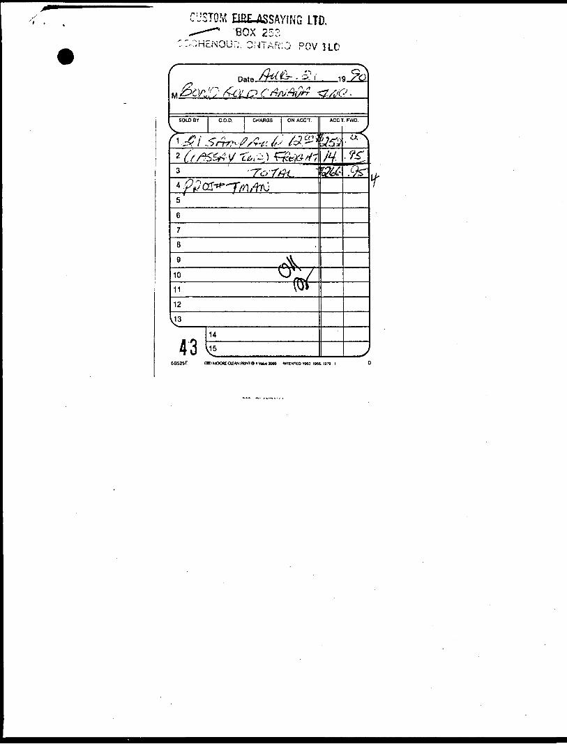
"APAUL'S CUSTOM FIRE ASSAYING LTD.
PAULOKANSKI.Assayer Box 253, Cochenour, Ontario POV 1LO
Phone: Bus. (807) 662-8171Res. (807) 662-3361
Fax: (807)662-1155
XK8 Bond Gold Canada Inc. ASSAY CERTIFICATE Date: Aug. 21 , 1 9990,
12
34
5
67
8
9
10
11
12
1314
15
16
17
18
19
20
21
22
23
2425
Sample No.
11401
02
03
04
05
06
07
08
09
10
11
12
13
14
1516
217
18
19
20
21
Description
TMAN (1 ASSAY TON)
I
"•
oz/ton Au
Traceit
ii
ii
ii
it
ii
ii
ii
ii
ii
n
it
ti
it
n
ii
n
n
it
n
oz/ton Ag
Assayer

Au
PAUL'S CUSTOM FIRE
PAULOKANSKI.Assayer Box 253, Cochenour, Ontario POV ILO
^807) 662-8171 Res. (807) 662-3361
Fax: (807)662-1155
Bond Gold Canada Inc. ASSAY CERTIFICATE Date: Aug. 28-90
1
2
3
4
5
6
7
8
9
10
11
12
13
14
15
16
17
18
19
20
21
22
23
24
25
Sample No.
11422
23
24
25
26
27
28
29
30
31
32
33
34
35
36
37
38
39
40
41
42
43
44
4R
46
Description
Proj. T.M.A.N. (1 Assay Ton)
*
oz/ton Au
Trace
n
it
it
it
it
n
it
it
it
n
it
it
ii
n
M
it
.84
Trace
nit
n
n
ii
n
oz/ton Ag
As&ayer

PAUL'S CUSTOM FIRE ASSAYING LTD.
PAULOKANSKI.Assayer Box 253, Cochenour, Ontario POV1LO
Phone: Bus. (807) 662-8171Res. (807) 662-3361
Fax: (807)662-1155
Bond Gold Canada Inc. ASSAY CERTIFICATE Date: Aug. 28-90
12
34
5
67
8
9
10
11
12
1314
15
16
17
18
19
20
21
22
232425
Sample No.
11447
48
49
50
51
52
53
54
55
56
57
58
5960
61
62
63
64
65
66
67
68
69
70
71
Description
Proj. T.M.A.N. (1 Assay Ton)
t
oz/ton Au
Traceii
u
ii
M
u
ii
u
u
iiti
u
ti
u
n
ii
M
uM
u
M
M
n
M
-
oz/ton Ag
Assa/er

Au
Bond Odd Canada Inc.
PAULS CUSTOM FIRE ASSAYING LTD.
PAULOKANSKUssayer Box 253, Cochenour, Ontario POV1LO
ASSAY CERTIFICATE
Phone: Bus. (807) 662-8171Res. (807) 662-3361
Fax: (807)662-1155
Date: Aug. 13, .1990.
12
34
5
6789
1011
12
13141516
17
18
19
20
2122232425
Sample No.
QA-1
2
3
4
Description
$TMAN<1 ASSAY TON)
i
'
oz/ton Au
Trace
.05
Trace
,27
oz/ton Ag

v -,<>3LD CANADA INC. !UbM
INVOIC 30343536
a N O-'.
C2119T CHEQUE NU.
INV DATE 90/08/08 90/08/13 90/03/13 90/08/13
DESCRIPTION CUSTOM FIRE CUSTOM FIRE CUSTOM FIRE CUSTOM FIRE
10640 90/09/05
VOUCHER GROSS AMOUNT DISCOUNT2876 4,399.232879 241.502877 128.502878 48.00
NET AMOUNT4,399.23
241,50128.5048.00
TOTAL 4,817.23 4,817.23

"**** tro

BQf4»t?OLD CANADA INC. ^*^j TUTbtl,21191
INVOICED. 4^-90082143-90082144-900821
!NV DATE 90/08/21 90/08/21 90/08/21 90/08/21
CHEQUE NO, 10713 90/09/19
DESCRIPTION 16 SAMPLES 21 SAMPLES 89 SAMPLES 147 SAMPLES
-VOUCHER GROSS AMOUNT DISCOUNT 3174 192.00 3176 . 266.95 3175 1,068.00 3177 1,797.43
NET AMOUNT192.00266.95
1,068.001,797.43
TOTAL 3,324.38 3,324.38
BOND GOLD20 ADELAIDE
TfQRONTO,' , t'''.l'?.\2£i! 4k'ii
: !JSTQM BRLASSAYING LTD.~~*~~* BOX 253:H£NOUf.'. ONTARIO PQV HO
Date. _19
SOLO BY C.O.D, CHARGE ON ACC'T.
/ v-6
7
8
9
10_
11
12
43TMV5
5B525E OIDMOOtt OIAN PUNT »»V** WOO MTENTEO 1963 1966 1979 1

BOND GOLD CANADA INC. 10792
INVOICE NO. 47-900828
INV DATE 90/08/28
CHEQUE NO. 10755 90/09/26
DESCRIPTION 50 SAMPLES
VOUCHER GROSS AMOUNT DISCOUNT NET AMOUNT 3178 643.50 643.50

&OL D CANADA-
flovfs
Sb,lo.mtllic (\ M
f\Cfio*5 (
nv\ /*•"* &L*#*
" > mO' 1fl«,»ilic/ fl 1
1 lr ' " v, , ' *%'**' y ' "" '^j.j.'f -'•>"^>j/ ) ^ v ' **• / It y/i ,J_-; i^^ yL/ii ^ -» !• »» ** -^^ ^ ,- AM /, i. x °^«^nss^
\ <£'" inx.^cedar
6475 /<?
lo(c),mpy:'' l^x?.^ older a -*11- ———JS^te^'J spruce
1 ^^ ^ t"'" '
poplor
T
<^\-X?* ^$i-'-^^9k ^ '.'/. (^'V^lo
?«"//
^-J.0tb 1^
Jor 5c,5d,w
i.x v^°
.!, ^J / /ijA /*•• * * /^ ,'/ / / Wd)^ _J Iy7_x-x ic cw ' ' le ,t / ^ / ,'/ / 1°lr / oldtrs ,'.' J^- ~r*^^-^^ u«/ t» h,e ./ , -t r*Z- / s' J t . / o^/~^—~--V///« "-N y //* / ' ,'^*' e/ «' T^^sfe-Lj ^-o v/,;' poplpf it l- /" ^<
•* e«dora / j~ / V»'/ir^~-i~iWLl Y '/ o ldVfib \ vv / ^^f\^. ««« ^. »•/ jr «$j °^\iT7;^y' ^x^ar-/ te ^I NIK/- ^ -"- r/W^' "s . ife9<i0J
bush mopl*\ Zc
.. bushmopie /* pme/
A /
/?o,c
/ s * .t! fc /, ' / o ,*• ^ -.n' • ^ I i ' \\ zb zd"«*° </ ./•) : ih i ("^ " to,v 0 L ' I_•? r—) S^ I v Zo.wW.OV ! j Zo \/ ' ' » '
$ &.tt./'''/ .<?* Jim ' Vf "V-^.M^. ^ftffi&&&/&. V Sai -2!^ 4 <• 4,,,,./^^^w^^^K) ,„ - ,£r/;U^
X.^ i|? ^\ / Y^.T-7? ^lir-jEs- f -'
poplor ("ij. bushmt
ponrf60
^boMSl^J^'. _-.—— ——sai/ ——j"\t? »a' A*
poplar Nil — bush maple
| QV V.5b(6o)
poplor I 2c J ^^ Jspruce ^ f \r ^ v v_^ J sprue
-TOT V, **
«rt>,///A'(V <to°r**!k«»?W*oai*9
1 J V "' rA^""v,/>
glacial/io\ wi V oi
;»«• oloeW III!
poplor
60 ,
old*/* ,C/L^ Vib
394450<v
\M
buthjnopM
&I bush mople
jock pin* Oloclol '' •III So
iJpint 11
i!ei"
60,^J^ ty \ fa* "^/ Vv \/ cedar Y, / /A
eo; f *ff r
cedor
^ety&^n. >CaX^
poplar cedor
•Scale:50 »n 'OOn
Property

UPPER MANITOU
LAKE
ei^tfe^
——/_!______1
Twentieth Century Mine /
L ———1_
;**£-, u z»*&&~»^\ ; ;•,'.- •fca^:fe^^^
fc--« IT — I — 7
MANITOU LAKE PROPERTY
CLAIM MAP S cale- l"= 1/2 mile

Ministry olNorthern Developmentand Mines
Ontario
DOCUMENT No.W900i«33y
ng ActReport of Work(Expenditures, Subsection 77(19)) 52Fe7SW«a«6 2.13582 LOWER MANITOU LAKE 900
Type of Work Performed Mining Division Township or Are.
Recorded Holder Prospector's Licence No.
Address Telephone No.
Work Performed By
Name and Address of Author (of Submission)
//9sD»t» Wh«n Work WM Performed
" O-T 90 IcV| Mo. | Yr. I Oty I Yf.
All the work was performed on Mining Claim(s): Indicate no. of days performed on each claim. •See Note No. 1 on reverse side __
Mining Claim No. of Days Mining Claim No. of Dayt
£&
Mining Claim No. of Oayi Mining Claim No. of Days
Mining Claim No. of Dayt Mining Claim No. of Days Mining Claim No. of Dayt Mining Claim No. of Days Mining Claim No. of Dayt Mining Claim No. of Dayt
Mining Claim No. ol Days Mining Claim No. ol Dayt Mining Claim No. of Days Mining Claim No. of Days Mining Claim No. of Dayt Mining Claim No. ol Dayt
InstructionsTotal days credits may be distributed at claim holder's choice. Enter number of days credits per claim in the expenditure days credit column (below). ___ __________
Calculation of Expenditure Days Credits Total Expenditures______
Total Pays Credits
Total Number of Mining-Claims Covered by this Report of Work
Mining Claims (List in numerical sequence). If space is insufficient, attach schedules with required informationMining Claim
Prefix
X.Number
<K^^-
Expend. Days Cr.
?r>
Mining ClaimPrefix
Total Number of Days Performed
52,o
NumberExpend. Days Cr.
Mining ClaimPrefix Number
Total Number of Days Claimed
£0.0
Expend. Days Cr.
Mining ClaimPrefix Number
Expend. Days Cr.
Total Number of Days to be Claimed at a Future Date
32.oCertification of Beneficial Interest *See Note No. 2 on reverse side
1 hereby certify that, at the time the work was performed, the claims covered in this report of work were recorded in the current recorded holder's name or held under a beneficial interest by the current recorded holder.
Date
&CT tt l^O
Reco d«d Holder or Agent (Signature) j - X"1 r\ r "iXXICu^ L__-"L){ JLS\\Q/)
Certification Verifying Report of WorkI hereby certify that I have a personal and intimate knowledge of the facts set forth in the Report of Work annexed hereto, having performed the work or witnessed same during and/or after its completion and the annexed report is true.Name and Address of Person Certifying
At'TCTelephone No. Date
COT -2.5
Certified By (Signature)
For Office Use OnlyTotal Days
Cr. Recorded
£0
Dale Recorded, , \Od
Date Approved as Recorded
Mining Recorder
Received Stamp
I; I- 1Provincial Manager, MTning^CaricI
8T8 C89«36I
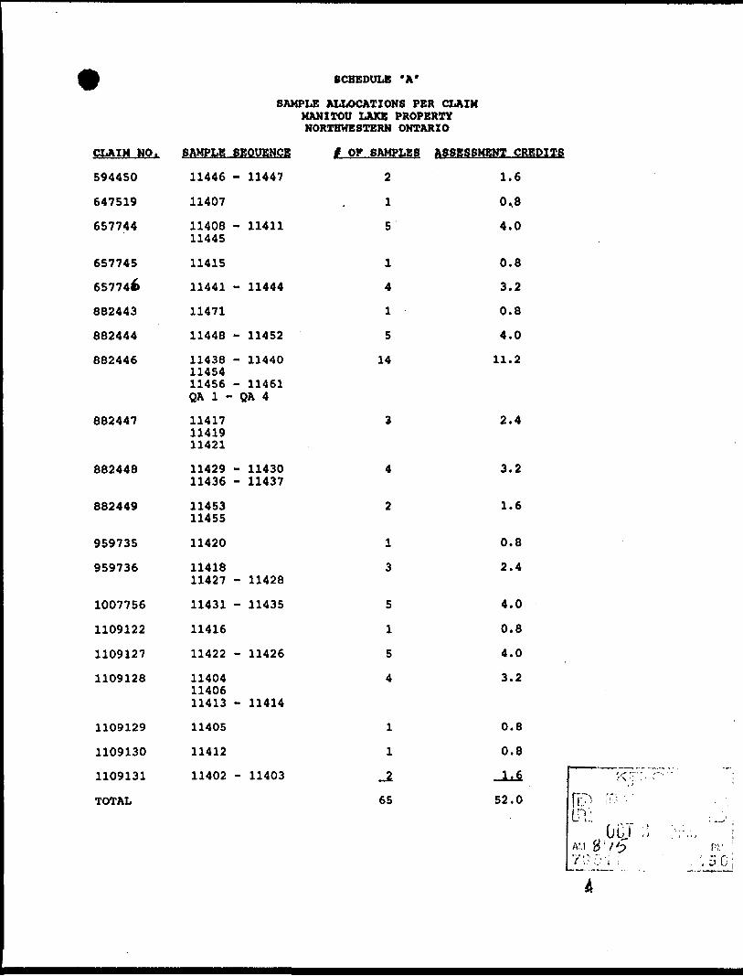
SCHEDULE *A"
SAMPLE ALLOCATIONS PER CLAIM MANITOU LAKE PROPERTY NORTHWESTERN ONTARIO
CLAIM NO.
594450
647519
657744
657745
657746
882443
882444
882446
882447
882448
882449
959735
959736
1007756
1109122
1109127
1109128
1109129
1109130
1109131
TOTAL
SAMPLE
11446
11407
11408 11445
11415
11441
11471
11448
11438 11454 11456 QA 1 -
11417 11419 11421
11429 11436
11453 11455
11420
11418 11427
11431
11416
11422
11404 11406 11413
11405
11412
11402
SEQUENCE
- 11447
- 11411
- 11444
- 11452
- 11440
- 11461 QA 4
- 11430 - 11437
- 11428
- 11435
- 11426
- 11414
- 11403
t OF SAMPLES
2
1
5
1
4
1
5
14
3
4
2
1
3
5
1
5
4
1
1
65
ASSESSMENT CREDITS
1.6
0,8
4.0
0.8
3.2
0.8
4.0
11.2
2.4
3.2
1.6
0.8
2.4
4.0
0.8
4.0
3.2
0.8
0.8
JUS !<•;:::..52.0 Cr?! '"-
In: < ^ ' ]

Ontano
Ministry ofNorthern Development
nd Mines
Report of Work Mining Act (Expenditures, Subsection 77(19))
Instruction*• Please type or print.• Refer to Subsection 77(19), the Mining Act for assessment work
requirements and maximum credits allowed under this Subsection.• Technical Reports, maps and proof of expenditures in duplicate
should be submitted to Mining Lands Section, Mineral Development and Lands Branch.
Type of Work Performed Mining Division Township or Area
Recorded Holder Prospector's Licence No.
Address #
Telephone No.
/ / O c 5rWork Performed By
Name and Address of Author (of Submission) Oat* When Work wa» PerformedFrom: _ To: _jo of °to 04 ce 9o
DSy I Mo. I Yr. Day I ^1o. I Yr,
AH the work was performed on Mining Claim(s): Indicate no. of days performed on each claim. "See Note No. 1 on reverse side
Mining Claim No. of Days Mining Claim No. of Days
<tTT\L
Mining Claim No. of Days Mining Claim No. of Days
Mining Claim No. of Days | Mining Claim No. ot Days Mining Claim No. ot Days Mining Claim No. of Days Mining Claim No. of Days Mining Claim No. of Days
Mining Claim No of Days I Mining Claim No. of Days Mining Claim No. of Days Mining Claim No. of Days Mining Claim No. of Days Mining Claim No. ot Days
instructionsTotal days credits may be distributed at claim holder's choice. Enter number of days credits per claim in the expenditure days credit column (below)._____________________
Calculation of Expenditure Days Credits Total Expenditures
Total Days Credits
Total Number of Mining-Claims Covered by this Report of Work
Mining Claims (List in numerical sequence). If space is insufficient, attach schedules with required informationMining Claim
Prefix I Number
tf 9^^^
Expend. Days Cr.
r?r>
Mining ClaimPrefix
Total Number ot Days Performed
^ , 0
NumberExpend. Days Cr.
Mining ClaimPrefix Number
Total Number of Days Claimed
£0.0
Expend. Days Cr.
MPrefix
ning ClaimNumber
Expend. Days Cr.
Total Number of Days to Oe Claimed at a Future Date
32.0Certification of Beneficial Interest "See Note No. 2 on reverse side
I hereby cert fy that, at trie time the work was performed, the claims covered in this report of work were recorded in the current recorded holder's name or held under a beneficial interest by the current recorded holder.
Date
C-CT
Recorded Holder or Agent (Signature)
Certification Verifying Report of Work1 hereby certify that 1 have a personal and intimate knowledge of the facts set forth in the Report of Work annexed hereto, having performed the work or witnessed same during and/or after its completion and the annexed report is true.Name and Address ot Person Certifying
Telephone No.
For Office Use OnlyTotal Days
Cr. Recorded
1
Date Recorded
Date Approved as Recorded
Mining Recorder
Provincial Manager, Mining Lands
Date Cert lied By (Signature)
or.r^'s, i 0]0^. .J^-f L<Lfi,~> C-C].iL^.pReceived Stamp '

SCHEDULE "A*
SAMPLE ALLOCATIONS PER CLAIM MANITOU LAKE PROPERTY NORTHWESTERN ONTARIO
CLAIM NO.
594450
647519
657744
657745
657746
882443
882444
882446
882447
882448
882449
959735
959736
1007756
1109122
1109127
1109128
1109129
1109130
1109131
TOTAL
SAMPLE
11446
11407
11408 11445
11415
11441
11471
11448
11438 11454 11456 QA 1 -
11417 11419 11421
11429 11436
11453 11455
11420
11418 11427
11431
11416
11422
11404 11406 11413
11405
11412
11402
SEQUENCE # OF SAMPLES ASSESSMENT CREDITS
- 11447 2 1.6
- 11411
- 11444
- 11452
- 11440
- 11461 QA 4
- 11430 - 11437
- 11428
- 11435
- 11426
- 11414
- 11403
1
5
1
4
1
5
14
3
4
2
1
3
5
1
5
4
1
1
_2
65
0.8
4.0
0.8
3.2
0.8
4.0
11.2
2.4
3.2
1.6
0.8
2.4
4.0
0.8
4.0
3.2
0.8
0.8
-ii
52.0

Ministry ofNorthern Developmentand Mines
"DOCUMENTNO.
Ontario
Mining ActReport of Work * • * ~t>\s C~(Geophysical, Geological and Geochemical Surveys)
Instruction*- Please type or print.
tn/PfTtmVining Act lor assessment work requirements prElLwiowed per survey type.
• II number ol minjng claims traversed exceeds space on this form, attach a list. i
I maps in duplicate should be submitted to n, Mineral Development and Lands Branch:
Type of Survey(s) Mining Division Township or Area
Recorded Holder(s)
Addres»_G£>L&_ ./A/C...
//c>o - £o - 57* g j^!
Prospector's Licence No.T -
Telephone No.
Survey Company
Name and Address of Author (of Geo-Technical Report) Date of Survey (from t to)1C Cn ^O !O4 O8Day I Mo I Yr. Day I Mo I Yr
Credits Requested per Each Claim in Columns at right Mining Claims Traversed (List in numerical sequence)Special Provision*
For first survey:
Enter 40 days. (This includes line cutting)
For each additional survey: using the same grid.
Enter 20 days (lor each)
Man Day*
Complete reverse side and enter tolal(s) here
Airborne Credit*
Note: Special provisions credits do not apply to Airborne Surveys.
Geophysical
• Electromagnetic
• Magnetometer
• Other
Geological
Geochemical
Geophysical
- Electromagnetic
- Magnetometer
- Other
Geological
Geochemical
Electromagnetic
Magnetometer
Other
Days per Claim
HO
Days per Claim
Days per Claim
Total miles flown over claim(s).Date ' Recorded Holder or Agent (Signature)
GC-T C'3 / 9C> \y\i. ( tiOO ( r/\ Lu^iff
Mining ClaimPrefix
KK
Number
HCtf 1
Mining ClaimPrefix Number
OCT
Mining ClaimPrefix Number
19
"MINING UJNDS SJECIION
Certification Verifying Report of Work
Total number of mining claims covered by this report ol work.
I hereby certify that I have a personal and intimate knowledge of the facts set forth in this Report of Work, having performed the work or witnessed same during and/or after its completion and annexed report is true.Name and Address o! Person Certifying
uaTelephone No.
M^C
sr e ro^o/oroDate
C c,r 03 / C1Cert tied By (Signature)
For Office Use OnlyReceived Stamp
r KENORAM '-••' - .T. r.-V.
(jCT i>- .990
•362 (89)06)

Ministry ofNorthern Developmentand Mines
Ontario
DOCUMENT No
Mining ActReport of Work(Geophysical, Geologi<
Instructions• Please type or print.• Refer to Section 77. the Mining Act for assessment work requirements
and maximum credits allowed per survey type. If number of mining claims traversed exceeds space on this form.
list.Reports and maps in duplicate should be submitted to
Lands Section. Mineral Development and Lands Branch:Type ol Survey(s)
Recorded Hhlderls)
Mining Division Township or Area
Prospector's Licence No./>00 UQKE
Address
HOG- 7Telephone No.
Survey Company
Name and Address of Author (ol Geo-Technical Report) Date of Surv
Credits Requested per Each Claim in Columns at right Mining Claims Traversed (List in numerical sequence)
Certification Verifying Report of Work

•Viinisvry otNorthern Developmentand Mine*
OntarioW9001
rN I NO. I'338|
MiReport of Work
Act (Geophysical, Geological and Geochemical Surveys)
Instruction*• Please type or print.• Refer to Section 77, the Mining Act for assessment work requirements
ind maximum credits allowed per survey type.• If number of mining claimt traversed exceeds space on this form,
attach a list.• Technical Reports and map* In duplicate should be submitted to
Mining Lands Section. Mineral Development and Land* Branch:Type of Surveyls) Mining Division Town»hip of Area
Recorded Holders) Prospector's Licence No.
Address
*noo- £.0Telephone No.
Sre,Survey Company
Name and Address of Author (of Geo-Technical Report) of Su
Credits Requested per Each Claim in Columns at right Mining Claims Traversed (List in numerical sequence)Special Provisions
For first survey:
Enter 40 days. (This include* line cutting)
For each additional survey: using the same grid.
Enter 20 days (for each)
Man Day*
Complete reverse side and enter total(s) here
Airborne Credit*
Note: Special provisions credits do not apply to Airborne Surveys.
Geophysical
• Electromagnetic
• Magnetometer
• Other
Geological
Geochemical
Geophysical
• Electromagnetic
• Magnetometer
• Other
Geological
Geochemical
Electromagnetic
Magnetometer
Other
Days per Claim
HODays per
Claim
Days per Claim
Total miles flown over claim(s).3s;e J Recorded Holder or Agent (Signature)
Mining ClaimPrefix
KKKK
Number
LC'^t-T-U-Ct'
k5*^tfc^S^^BSloo^nsb
Mining ClaimPrefix Number.
———— » •>. r <"> » (- V.
;;i;;;NQ i
Mining ClaimPrefix
,; / V
— tt
-.H3S J
Total number of mining claims covered by this report of work.
Number
t iv
ECT!ON
•
4-Certification Verifying Report of Workl hereby certify that 1 have a personal and intimate knowledge of the facts set forth in this Report of Work, having performed the work or witnessed same during and/or aher its completion and annexed report is true.Name and Address of Person Certifying sre. TT^OOTO
>2 <89'06I

itarioMinistrvof Mining Lands Section MinstryoT 1 59 street 4 th FloorNorthern Development SUDBURY, Ontario and Mines P3E 6A5
Ministere du Telephone: (705) 670-7264Developpement du Nord F axs (705)670-7262etdes Mines , Your File: W9001. 338/
X Our File : 2. 13582
December 28, 1990
Mining RecorderMinistry of Northern Development and Mines808 Robertson StreetP. O. Box 5200KENORA, OntarioP9N 3X9
Dear Madam/Sir:
RE: Notice of Intent dated November 20, 1990 for Geological Survey submitted on Mining Claim K 657744 et al in Lower Manitou Lake.
The assessment work credits, as listed with the above mentioned Notice of Intent have been approved as of the above date.
Please inform the recorded holder of these mining claims and so indicate on your records.
sincerely
R. C. GashinskA/Provincial Manager, Mining LandsMines and Minerals Division
^//DM/dvl Enclosure
cc: Mr. W. D. Tieman Resident Geologist Mining and Lands Commissioner Kenora, Ontario Toronto, Ontario
Bond Gold Canada Toronto, Ontario

x— x MinWry oi Technical Assessment f »• VV 1 Northern Development • 9 i 'ttft? .XT,* .^w»in« Work Credit* eMJ&B*
Ontario »
•
]D»»e IMIntna Recorder* ft.port of
| Nov. 20/90 |tt9ttol.338
: R»cord«a Holder
Bond Gold Canada Inc.Townihip or Area
Lower Manltou LakeType ol survey and number of
Assessment days credit per claimGeophysical
M»9"etQrn«m . d»vt
Radiometrlc. ... .-,.. - ,.— .- -. days
Induced polarization ..__._, .„_... days
n.Ktr davs
Section 77 (19) See "Mining CUIms Assensd" column
Geological,. 25.6 ...days
Rp(vhpm!r»l dayi
Man days Q Airborne Q
Special provision 0 Ground Q
Q Credits have been reduced because of part!*) coverage of claim*.
Q Credits have been reduced because of corrections to work dates and figures of applicant
Mining Claims Assessed
K 657744, 657747 959735, 1007756
Special credit* under section 77 (16) for the following mining claim*
No credits have been allowed for the following mining daimiQ not sufficiently covered by the survey Q Insufficient technical data filed
The Mining Recorder may reduce the above credits if necetury in order that the total number of approved assessment days recorded on each claim does not exceed the maximum allowed at follows: Geophysical • 80; Geologocal • 40; Ceochemical • 40; Section 77(19) -60.
628 (65/12)

anoMinistry ofNorthern Developmentand Mines
Ministere du Developpement du Nord et des Mines
Mining Lands Section
S59 Cedar Street, 4th Floor iUDBURY, Ontario P3E 6A5
Telephone: (705) 670-7264Fax: (705) 670-7262
Your File: W9001. 263 & 313Our File : 2. 13582
December 3, 1990
Mining RecorderMinistry of Northern Development and Mines808 Robertson StreetP. 0. Box 5200KENORA, OntarioP9N 3X9
Dear Madam/Sir:
RE: Notice of Intent dated October 30, 1990 for GeologicalSurveys submitted on Mining Claims K 882442et al in LowerManitou Lake.
The assessment work credits, as listed with the above mentioned Notice of Intent have been approved as of the above date.
Please inform the recorded holder of these mining claims and so indicate on your records.
sincerely
R. C. GashinskiA/Provincial Manager, Mining LandsMines and Minerals^ Division
Enclosure
cc: Mr. W. D. TiemanMining and Lands Commissioner Toronto, Ontario
Bond Gold Canada Inc. Toronto, Ontario
Resident Geologist Kenora, Ontario
Ministry ofNorthern Developmentand Mines
Technical Assessment Work Credits
DateOct. 29, 1990
File2.13582
Mining B*cord«r'i FUport olWofk S9001.263
Recorded HolderBOND GOLD CANADA INC
Township or Ar«aLOWER MANITOU LAKE
Type of survey and number of Assessment dayt credit per claim
Geophysical
Other days
Section 77 (19) See "Mining Claims Assessed" column
29.4 Rpnlngiral dayt
fiervhemiral d»y«
Man days Q Airborne Q
Special provision £3 Ground I j
jffi Credits have been reduced because of partial coverage of claims.
{ I Credits have been reduced because of corrections to work dates end figures of applicant.
Mining Claims Assessed
K 882442 to 449 incl
959736, 959738
1109120 to 134 incl.
Special credits under section 77 (16) for the following mining claims
Mo credits have been allowed for the following mining claims
I | not sufficiently covered by the survey I | insufficient technical data filed
The Mining Recorder may reduce the above credits if necessary in order that the total number of approved assessment'days recorded on each claim does not exceed the maximum allowed as follows: Geophysical - 80; Geologocal • 40; Geochemical • 40; Section 77(191-60.

Ministry otNorthern Developmentand Mines
Technical Assessment Work Credits
Or October 29/90
Fll.
2.13582Mining Recorder's R«port of Work No.
W9001.313
Recorded Holder
BOND GOLD CANADA INCTownship or Are*
LOWER MANITOU LAKE
Type of survey and number of Assessment days credit per claim
Geophysical
Section 77 (19) See "Mining Claims Assessed" column
Rpologiral 2 3 ' 7 dayt
Man days (~| Airborne Q
Special provision ££J Ground l~~i
(j^l Credits have been reduced became of partial coverage of claims.
I | Credits have been reduced because of corrections to work dates and figures of applicant.
Mining Claims Assessed
K 1109135 - 136
Special credits under section 77 (16) for the following mining claims
No credits have been allowed for the following mining claims
[ | not sufficiently covered by the survey insufficient technical data filed
The Mining Recorder may reduce the above credits if necessary in order that the total number of approved assetsment days recorded on each claim does not exceed the maximum allowed as follows: Geophysical -80; Geologocal -40; Geochemical • 40; Section 77(19) -60.
828 (85/12)

HONIHiOI.DCANADAINC.
0(11, II f.ANAilT INC.
November 01, 1990
Mining Lands SectionAttn: Dale Messenger880 Bay Street n £ f f. ! '• ; " . \3rd Floor K L " L ; v L ^Toronto, OntarioM5S 1Z8 NOV oi 191IU
MINING LANDS SECiiONDear Dale,
Please find enclosed duplicate copies of the geological map which I spoke with you about yesterday. I would appreciate it if you could replace the field copy of this map originally submitted with the geology report for W9001.263 and W9001.313 with this drafted version.
Thank-you very much for your assistance.
Yours truly,
Alison Dunlop Research Geologist
/acd Encl.

BONDGOUK'ANADA INC:.
:<l Aik-hmloSlia'l. liaslSulk- 11(10liminlo, Onurio M5C 2'Ih
•lid .W7-IO.M4I(."»-!7-1257 I'jcsimik
November 01, 1990
Mining Lands Section Attn: Dale Messenger 880 Bay Street 3rd Floor Toronto, Ontario M5S 1Z8
Dear Dale,
G O 1.1) CANADA IN C
RECEIVEDNOV o; 1990
MINING LANDS SECTION
Please find enclosed duplicate copies of the geological map which I spoke with you about yesterday. I would appreciate it if you could replace the field copy of this map originally submitted with the geology report for W9001.263 and W9001.313 with this drafted version.
Thank-you very much for your assistance.
Yours truly,
Alison Dunlop Research Geologist
/acd Encl.

BONIXiOmCANADAiNC.
Sink- 110(1•h'loiiio, Oiiiuiii. MM'2'U. .13582-41d .?(>7-KMl-llfi'J-17 -I?S7 hu-Minik- C OM) CAN ADA" INC.
October 05, 1990
Mining Lands Section 880 Bay Street 3rd Floor Toronto, Ontario M5S 1Z8
To Whom It May Concern:
Please find enclosed duplicate copies of a geological report and maps to cover Report of Work W9001.263 filed with the Kenora Mining Recorder in August and, a Report of Work just recently filed. I have also enclosed copies of each of these Reports of Work.
If you have any questions regarding this filing, please feel free to contact me. Thank-you for your attention.
Yours truly,
Alison DunlopResearch Geologist ^ r ^ , ^ , t
i\ i i v. I', I V? 1;:
, „ 0'j'i Ob 19/acd
MINING LANDS SECTION

1 /","• k I • '•( I, (1
HARPER LAKE'-93 e> 00'
S.' f "' i i,w>f / > iy/ / lOSNVf
JOtiOt 51tJ)7_ _ 4- _ _: -
^.! .^ ....,.-,.,«.-" *- -1^ -_. i. ^
/ ^ ' J~~ ~ ~^t*^J l1^.
x ' /IS- '-
>i-m , o •»•* --- - - ~ *- - -——L ——
1 I LT - "+J+ ~* ¥ — •** Ir _ ^._ r ^
..^p
sr .. rTj!^JL .' - d^.^L^\ _ i/-
MANG LAKE - C -26856aF«76WMM 8.13SB8 UOWER MAN I TOO LAKE 200
LEGENU
PATENTED .LAND • "• &CROWN LAND SALE C S.LEASES ©LOCATED LAND LorLICENSE OF OCCUPATION LJMINING RIGHTS ONLY MROSURFACE RIGHTS ONLY SSOROADSIMPROVED ROADSKING'S lii^HWAYSRAILWAYS —— - ——POWEH LINES ^~-~-* MARSH OR MUSKEG (\ JL?MINES " ^^ 5^CANCELLED CPATENTED RO ^
REFERENCESAREAS WITHDRAWN FROM
M^O. - MINING BIGHTS ONLY
SHO
f/ + S -
«^t rtlGHTS ONLY
b *
KENORAMINING DIV
JUN261990AM
7891011 12123456
.CALf- 1 INCH « 40 C iA'NS
o ' r oo .-ooo
o ?oo <ooc
AREA
LOWER MANITOU LAKE£
,
FORT r"RAMC£S-VvMINING DIVISION
KENORAl\KO T JTltE/ RECI£TF V C:V, (
Ministry of
Rcsc '•--;-*«O'iti-,r
hunt)
IT.: i^r] G- 2683
P- —.—— i • >at j

BASELINEo+oo w
2---OO E
4+ooe
6-HDOE
8+OOE
s£x r^ ^ \ / \"~^- ^i >>Ksu^ /.0 /A !°?. v / ':-:"*T~-^CX >^ ,->.
iu, cm bio I*-V_(gatobroic)
_.-3W..,-
Ic, F« carb, cfti
2o
K /
str sit cht-F* schist 24
(0*00 E
MA N I T 0 U ST R A I T S
\
oo•t-
a o
CVi
O O+•IO M
o o•t-
o o-(- PJ
0o
m
MAWCTOU LAKE
a •a
PNJPSPRBAi_CEDMAPBIRW!LALD
2d CMonte-sencite schist
SUBALKALIC MAFIC METAVOLCANIC ROCKS
1 Unsubdividedla Medium to fine-grained flowsIb Coarse-grained flows (gabbroic)Id Plagioclase-phyric flowsIg Autoclastic brecciaIh Plagioclase-phyric coarse-grained flowsIn CWoritic schist
SYMBOLS
Strike & dip of SI Strike & dip of S2 Mineral lineationStrike & dip of quartz vein/veinlet: barren Outcrop; large, small Shear zoneGeological contact; observed Quartz vein trend Trench ShaftClaim post; located, assumed
^ Cliff face; height in metres>- R idge; height in metres^ Path or portage"^- Stream; intermittent
SwampBeaver lodge
VEGETATIONPineJack pineSpruceBalsamCedarMapleBirchWillowAlder
Metres50 0 50
250 0
100 150
250
200
500
Feet
2. 13582BOND GOLD CANADA INC.
MANITOU PROPERTYDISTRICT OF KENORA. ONTARIO
TOPOGRAPHYAND
GEOLOGY MAPGEOLOGIST : SBohon/ S
SCALE: i: zsoo
OFMWM J. LM.
REVISED:
DATE:
—• ^

f
UPPER
MA N I TO U
IO t- OC W
LAKE
CARLETON
W
LAKE
4t-OO W
2HXDW
040
LEGEND
LITHOLOGV
POST-TECTONIC INTRUSIVE ROCKS FELSIC PLUTONIC ROCKS
I4 14 linsubdivided14a Porphyritic & senate horneblende-
biotite & biotite-horneblende granodiorite, quartz norrzonite
METAVOLCANIC ROCKS
SUBALKALIC INTERMEDIATE METAVOLfANir

BASELINE 0-i-OOW
2+-00 E
4-»-OOE
6-K)OE
8+OO E
10*00 e
\ *f
\lb \\
lb{ gabbroic) cM dots
- -- (aabbrolc)^
<J ^-
-——'2a, lap.chl, ± ptag
^, mod-str sh la - ''-' (aabbroic)
/2a,Fe-carb
MA N I TO UWATSON'S
o0^CM
WINITOU LAKE 220 i v o o i0 0
OJ Q
Oo•1-OJ
'?'
4I II
granodiorite, quartz monzomte
METAVOLCANIC ROCKS
SUBALKALIC IHTEWCDIATE METAVOLCAMIC ROCKS
O'*
a •a
11445-tr,
PNJPSPRBALCEDMAPBIRWILALO
2 Unsubdivided2a Tuff-lapilli tuff2b Tuff-breccia2d Chlorite-sericite schist
SUBALKALIC MAFIC HETAVOLCANIC ROCKS
1. Unsubdlvidedla Medium to fine-grained flowsIb Coarse-grained flows (gabbroic)Id Plagioclase-phyric flowsIg Autoclastic brecciaIh Plagioclase-phyric coarse-grained flowsIn CMoritic schist
SYMBOLS
Strike & dip of SIStrike & dip of S2Mineral lineationStrike & dip of quartz vein/veinlet: barrenOutcrop; large, smallShear zoneGeological contact; observedQuartz vein trendTrenchShaftClaim post; located, assumedCliff face; height in metresRidge; height in metres Path or portage
• Stream; intermittent
Swamp Beaver lodgeRock geochemistry sample location and nurtber (tr - trace)
VEGETATION
Pine'Jack pine SpruceBalsamCedarMapleBirchWillowAlder
50Metres
50 100 150 200
Z50 250 500I——I 1——I
Feet
BOND GOLD CANADA INC.
MANITOU PROPERTYDISTRICT OF KEHORA, ONTARIO
GEOLOGY & GEOCHEMISTRY
t

LEGEND
LITHOLOGY
POST-TECTONIC INTRUSIVE ROCKS PELSIC PLUTONIC ROCKS
14 Unsubdivided14a Porpnyritic & seriate horneblende-
biotite & biotite-horneblende granodiorite, quartz monzonite
METAVOLCANIC ROCKS
SUBALKALIC INTERMEDIATE METAVOLCANIC ROCKS
I£I 2 Unsubdivided2a Tuff-lapilli tuff2b Tuff-breccia2d Chlorite-sericite schist
SUBALKALIC MAFIC METAVOLCANIC ROCKS
iI 1 Unsubdivided I———I 1
PNJPSPRBALCEDMAPBIRWILALD
a Medium to fine-grained flows Ib Coarse-grained flows (gabb^oic) Id Plagioclase-phyric flows Ig Autoclastic breccia Th Plagioclase-phyric coarse-grained flows Tn Chloritic schist
VEGETATIONPineJack pineSpruceBalsamCedarMapleBirchWillowAlder
SYMBOLS
<->-? Strike & dip of SI1 Strike & dip of S2
«-*— Mineral lineation-GO- Strike & dip of quartz vein/veinlet: barrenO' * Outcrop; large, small*~~~~ Shear zone_^"~^ Geological contact; observed
• •» Quartz vein trend>——< Trencha Shaft• D Claim post; located, assumed
-r-<"r~ Cliff face; height in metres
x^v Ridge; height in metres_*-*•* Path or portage _/ >N- Stream; intermittent
c '-^-s Swamp *£* Beaver lodge
geochemistry sample location f~~; io and number (tr - trace) \ K V
CARLETON
xQueen \ \ Alexandria \ VV. -tp
QA-I-trQA-2-1.71g Au/tQA-3-tr xQA-4-9.26g Au/t (grab) \
BOND GOLD CANADA INC.
MANITOU PROPERTYDISTRICT OF KENORA, ONTARIO
GEOLOGY & GEOCHEMISTRY
DRAWN BYa Meek a Assoc LT<t
GEOLOGIST =Boltan / S. Ledmieky
23O
** ^