bodenham neighbourhood development plan 2011-2031
TRANSCRIPT

BODENHAM NEIGHBOURHOOD DEVELOPMENT PLAN
2011-2031
CONTENTS Page
Map of Bodenham Parish and Neighbourhood Area 2
1. Introduction and Background 2
2. Key Issues, Vision and Objectives 7
3. Housing 11
Policy BNDP 1: Delivering New Housing 12
4. Settlement Boundaries 12
Policy BNDP 2: Settlement Boundaries 13
5. Criteria for New Housing 14
Policy BNDP 3: Mix, Type and Tenure of New Housing Development 16
6. Flood Risk and Drainage 17
Policy BNDP 4: Flood Risk and Drainage 18
7. Jobs and Local Services 18
Policy BNDP 5: Employment 19
Policy BNDP 6: Large Scale Economic Activities 21
Policy BNDP 7: Local Community Facilities 22
8. Open Spaces and the Environment 22
Policy BNDP 8: Protecting Landscape and Important Public Views 24
Policy BNDP 9: Landscape Design Principles 24
Policy BNDP 10: Protection and Enhancement of the Built Environment 25
Policy BNDP 11: Tranquillity and Light Pollution (Dark Skies) 26
Policy BNDP 12: Open Spaces 28
9. Renewable Energy 28
Policy BNDP 13: Renewable Energy 28
10. Delivering the Plan 29
11. Reviewing and Monitoring the Plan 30
Annexes:
A. National and Local Planning Policies. B. Evidence Base. C. Bodenham Neighbourhood Area -Key Environmental and Other Assets Protected from
Development under this Plan. D. Environment Agency River Flood Map and Bodenham Neighbourhood Area. E. Environment Agency Surface Water Flood Map and Bodenham Neighbourhood Area. F. Housing Growth in the Plan Period. G. Bodenham Moor – Settlement Boundary with Commitments since 2011. H. Bodenham - Settlement Boundary with Commitments since 2011. I. Bodenham Neighbourhood Area - Important Public Views.
With thanks to Mr Derek Foxton for the © front cover photographs.
1

1
Figure 1
INTRODUCTION AND BACKGROUND
National and Local Planning Policy
1.1 This draft Plan sets out a number of planning policies to govern land use and development within the Parish for the period up to 2031. These policies need to be read alongside existing national and county planning policies which apply within the Parish.
1.2 National planning policy is set out within the National Planning Policy Framework, which was published in March 2010 and is regularly updated and amended. The companion Planning Practice Guidance provides more practical advice as to how national policy is to be implemented.
1.3 Herefordshire Council is responsible for the production of the Local Plan, which sets out strategic planning policies governing development in the County up to 2031. The first document to be produced as part of the Local Plan was the Core Strategy. This sets out the overall context for the preparation of Neighbourhood Development Plans (NDPs), notably housing requirements, as well as many other policies on relevant issues such as employment, open space and infrastructure.
2

1.4 The policies and proposals contained within the NDP for Bodenham Parish (1) relate to the whole administrative area of the Parish as illustrated in Map 1 above. They have been written to complement, rather than duplicate, the policies contained in the NPPF and the Local Plan and the actions resulting from the Parish Plan. Where appropriate, reference is made to these three documents in the text of the NDP and links to them, and to the key sources providing the evidence on which the NDP is based, can be found in Annex B and on the Parish Website at: http://www.bodenhamparish.org.uk/evidencebase.asp .
The Parish and its Settlements
1.5 Bodenham is a mainly rural parish of some 2,139 hectares (5,286 acres) about 7 miles North of Hereford and 6 miles South of Leominster. The two main centres of population in the Parish are the village of Bodenham located to the West of the Parish within a designated Conservation Area and the larger residential area of Bodenham Moor to the East. There are a number of other smaller settlements scattered across the Parish.
0
10
20
30
40
50
60
70
0-4 5-9
Age
Bodenham Parish Age Profile
Male Female Source: Annual Mid-Year Population Estimates for the UK, Office for National Statistics © Crown Copyright 2015
Nu
mb
er
of
Re
sid
en
ts
10-1415-1920-2425-2930-3435-3940-4445-4950-5455-5960-6465-6970-7475-7980-84 85+
Figure 2
1.6 Population and Housing. The latest available statistics show that the population of the Parish is 1,042 and, as can be seen from the chart above, it includes a significant proportion of those above retirement age. More than half (57%) of dwellings in the Parish are owned by the householder outright, with a further 24% owned with the help of a mortgage, while private rented and social housing accommodation account for 9% and 6% of households respectively (see the chart on page 15).
1.7 Community Facilities. In addition to a regular bus service to and from Hereford, the Parish has a good range of well-patronised community facilities. In Bodenham there is the church and primary school, while Bodenham Moor has the parish hall, chapel, post office with shop, garage with shop, general store with workshop units, hairdressers, café (at the golf course), homes for the elderly administered by a charitable trust, a GP surgery with dispensary, and a telephone
1. In this NDP the name “Bodenham” is used in three contexts - “Bodenham Parish” referring to the whole parish/ neighbourhood area, “Bodenham Moor” meaning the main settlement East of the River Lugg and “Bodenham” denoting the main settlement in the Conservation Area West of the River. Areas within the Parish which are outside the two main settlements are referred to as “open countryside”.
3

kiosk lending library, together with accommodation and training run by local charities for those with learning difficulties.
1.8 Recreation. Outdoor recreation and sport are well catered for in the Parish with tennis courts, a bowling green, a golf course and a range of equestrian, angling, rambling, sailing and other opportunities, all available locally. A variety of indoor recreational activities also take place in the Parish Hall and the Chapel.
1.9. Transport and Moving around the Parish. The A49, which runs just outside the West boundary of the Parish, brings traffic to it from the North and the South, while the A417 provides the main route into the Parish from the North, East and South-East. Within the Parish, local roads provide sufficient access for motorised vehicles and, together with public rights of way, are well used by pedestrians, cyclists and horse riders. With drivers frequently ignoring speed limits, road safety is, however, a continuing concern.
1.10 Open and Amenity Spaces. Four areas of public open space and many other assets of local importance within the Parish are listed at Annex C. Three of these - Maund Bryan, Upper Maund with Whitchurch Maund, and Common Marsh - are registered Common Land. The River Lugg is designated a Special Area of Conservation and a Site of Special Scientific Interest. There are two other Sites of Special Scientific Interest in the Parish. Bodenham Lake, formerly a quarry working, is located to the West of Bodenham and this area includes a parcel of ‘brownfield’ land containing former quarry works buildings. The Lake is a designated Local Wildlife Site and its tranquillity and the opportunities it provides for leisure activities, such as walking, sailing and observing bird life, mean that it is highly valued by the community. The Parish is also served by a well-maintained network of public rights of way and is part of key routes for several local cycle clubs.
1.11 Wildlife. There are many habitats for diverse wildlife throughout the Parish and residents take an active interest, both individually and through several volunteer-led projects, in conserving and attracting wild birds, mammals, reptiles, amphibians, fish, insects, molluscs and plants. The apparent decline in the number of hedgehogs and owls has been attracting local attention.
1.12 Hydrology. The River Lugg flows from North to South through the Parish and the two main centres of population in the Parish, Bodenham and Bodenham Moor, are located in close proximity to, and either side of, it. A number of smaller watercourses flowing in an east to west direction also cross the Parish before outfalling to the River. At present water quality in the River does not meet EU standards, mainly because of high phosphate levels, and, although the Environment Agency and Natural England, together with other agencies, have initiated a Nutrient Management Plan to rectify this shortcoming, it has implications for housing and other development throughout most of the Bodenham Neighbourhood Area.
1.13 Flood Risk.
1.13.1 A significant proportion of the Parish has a history of flooding. For example, in 2007 some 40 residential dwellings in the Bodenham Moor area were severely flooded and many more garages, outbuildings and gardens also suffered damage. According to the Environment Agency (EA) Flood Map for Planning (Rivers and Sea) (see Annex D) large areas of the Parish located in Flood Zone 3 (high risk) and Flood Zone 2 (medium risk) are at risk of river flooding from the River Lugg and its minor tributaries. The EA Risk of Surface Water Flooding map (Annex E) also indicates significant areas of the Parish to be at risk of surface water flooding.
4

1.13.2 Recent flooding, including that experienced in 2007, was due to the combined effects of direct flooding from the River and local streams and from surface water flooding. The severity of the flooding was exacerbated by failure over the years to increase the capacity of hydraulic structures (for example, culverts under roads) to cope with the greater storm water run-off rates resulting from residential development, combined with inadequate maintenance of watercourse channels, drains and culverts. The local community, through the Bodenham Flood Protection Group, has done much to mitigate flood risk by implementing a programme of watercourse maintenance, but failure to upgrade the local surface water drainage system to cater for new housing estates built in Bodenham Moor over the past 50 years means that the system does not have the capacity to cope with extreme rainfall events such as that experienced in 2007. There is overwhelming evidence that, in particular, the culverts at the Ketch Lane (C1113) and Millcroft Road (C1121) junction and the culvert in the drainage channel West of Orchard Close need urgent replacement. Their inadequacy needlessly heightens the flood risk to the communities they serve and this will be further increased in future by climate change. It is essential that these two sections of the Bodenham Moor surface water drainage infrastructure are accorded the highest possible funding priority for improvements to be put in place if further severe flooding of properties is to be avoided.
1.14 Sewerage Infrastructure. Sewage disposal in Bodenham is by means of private septic tanks. Bodenham Moor has a public sewerage system, which Welsh Water consider to be capable of coping with the expected additional load to be imposed by known housing commitments, although there is a degree of uncertainty regarding the remainder of the plan period owing to the unknown nature of future windfall development. Welsh Water’s confidence is not, however, matched by that of local residents who have long regarded the system as inadequate. Not only is their own amenity adversely affected, but, while Welsh Water have to regularly deploy tanker vehicles on a reactive basis to empty the system, the flood risk from overloaded sewers and the pollutant load associated with intermittent discharges of sewage effluent pose a threat to the already poor water quality of the River Lugg and jeopardise the attainment of EU Water Framework Directive targets for the waterbody. It is the firm local belief that, unless reinforcement works are undertaken, the public sewer network will not have the capacity to receive and treat foul water from new developments in the Bodenham Moor area through the plan period and the inconvenience to residents and the risk to the environment can only increase.
1.15 Other Infrastructure. Improvements to the public water supply infrastructure and to local broadband provision have recently been made, although the latter is not yet complete. However, the reduction in the provision of regular public transport following funding cuts is a significant issue. Given the number of elderly residents in the Parish, the withdrawal of the bus service to Leominster, the Parish’s market town, is causing disquiet because it has denied easy access to shops, banks and medical/dental facilities for those without private transport. The recent introduction of a Community Wheels minibus service on Fridays has alleviated the situation somewhat for the time being, but it is too early to say whether this scheme will be extended indefinitely, much less expanded.
Preparing the Plan
1.16 This Plan has been prepared by a steering group comprising parish councillors and local volunteers. Additional support has been provided by a planning consultant. The Plan covers the
5

whole of Bodenham Parish which was approved as a Neighbourhood Area by Herefordshire Council on 22 April 2013 (see the map at Figure 1 on page 2 above).
1.17 The foundations of the Plan lie in two surveys carried out to secure the views of local residents on a wide range of issues, supplemented by feedback from drop-in events, open days at the Siward James Centre and Bodenham School, and other local publicity in the Parish Newsletter and on the Parish Website. The first Survey was that conducted under the auspices of the Parish Council during the development of the Parish Plan. Its results were published in October 2010, before the appearance of the Localism Act and the advent of neighbourhood planning. (2)
1.18 The second Survey was conducted specifically to inform the Neighbourhood Plan and looked at a rather broader range of issues than its predecessor. It was carried out in September/ October 2014, with the questionnaire being distributed to every local resident aged 18 years or over. It achieved a response of 52% and to preclude any possibility of bias the returns were analysed by an independent consultancy, Data Orchard CIC. To distil its findings still further the Steering Group then produced a paper which sought to draw firm conclusions from Data Orchard’s Report and, after prior circulation on the Parish Website, this ‘Summary and Conclusions’ document was discussed and approved at a public meeting in the Parish Hall on 10 March 2015. The ‘Conclusions’ now form the basis for the policies in this Plan. Not all of these, or the key issues which they raise, are capable of being tackled directly by this Plan or, indeed, through the planning system. Some, such as traffic speeds, speed limits and enforcement, fall to other regulatory provisions. However, in such cases the Plan may be able to help indirectly, for instance, by seeking developer contributions to support community actions.
1.19 An important part of the Steering Group’s early work was to conduct a detailed examination of the scope for land to be brought forward for residential development. This was also informed by Herefordshire Council’s 2009 Strategic Housing Land Availability Assessment (SHLAA) and subsequently validated against the 2015 SHLAA. The results, in the form of possible new or revised settlement boundary options, were displayed at the various drop-in and open day events and posted on the Parish Website. In particular, they led the Steering Group to conclude that only two areas were possible contenders as sites for major housing development in the Parish. Both were in Bodenham Moor and one was a parcel of land South of Chapel Lane, known locally as Shuker’s Field, while the other was the field East of England’s Gate Inn, with the latter being much the preferred location.
1.20 This preference was confirmed by local residents in their responses to the Neighbourhood Plan Survey mentioned above. It also prompted the Parish Council, already aware of the housing requirement being proposed in the then emerging Core Strategy and conscious of the need to encourage young families to make their home in the Parish, to take the proactive measure of fully supporting a planning application for 40 houses, including affordable dwellings, in the field opposite England’s Gate Inn. This proposal received planning consent in October 2015 and the houses are now nearing completion as the ‘England’s Field’ estate. At much the same time
2. Full details of this Survey and of the Neighbourhood Plan Survey mentioned in paragraph 1.18 can be found in the Neighbourhood Plan Evidence Base by going to the link in Annex B or direct to Bodenham Parish Website at http://www.bodenhamparish.org.uk/evidencebase.asp .
6

2
consent was refused for 49 houses on Shuker’s Field and these two decisions have formed the basis of the Bodenham Moor settlement boundary now embodied in this NDP. (3)
1.21 This draft Plan is subject to a Habitats Regulations Assessment because the River Lugg, which runs through the Parish, has a European-level designation as a Special Area of Conservation. It is also subject to a Strategic Environmental Assessment. Herefordshire Council issued a scoping report, the first stage of the assessment processes in July 2014. This concluded that further assessments would be required as the Plan proceeded and these Assessments of the Plan have been published accordingly.
Consultation
1.22 Throughout the Plan’s development local residents have been kept informed of progress in as many different ways as possible. At all stages notes explaining the nature and importance of Neighbourhood Planning have been available on the Parish Website with links to the detailed guidance notes provided on the Herefordshire Council website. All meetings of the Steering Group have been publicised in advance, both in the monthly Bodenham Newsletter and on the Parish Website. All these meetings have been open to attendance by any member of the public, and the importance of community involvement and feedback has been repeatedly stressed. Progress reports have been presented to all monthly Meetings of the Parish Council, which are also open to the public. These reports have been recorded in the Council’s Minutes, copies of which are available to all on the Parish Website. Similarly, each successive draft of the Neighbourhood Plan has been published on the Parish Website and comments invited on it and this has been supplemented with ‘open days’. At these local residents have been able to discuss all aspects of the Plan in detail with members of the Steering Group and to propose any amendments they wish. The full Consultation Statement can be accessed at http://www.bodenhamparish.org.uk/evidencebase.asp or through the link at Annex B.
KEY ISSUES, VISION AND OBJECTIVES
Key Issues
2.1 National and local planning policies set sustainable development at the heart of the planning system (4) – this is to meet the needs of the present without compromising the ability of
3. The Steering Group’s conclusions from its study are set out in its paper on ‘Potential Housing Land in Bodenham Neighbourhood Area’, which can be accessed through the link at Annex B or at http://www.bodenhamparish.org.uk/evidencebase.asp . 4. The NPPF explains that “There are three dimensions to sustainable development: economic, social and environmental. These dimensions give rise to the need for the planning system to perform a number of roles:
● an economic role – contributing to building a strong, responsive and competitive economy, by ensuring that sufficient land of the right type is available in the right places and at the right time to support growth and innovation; and by identifying and coordinating development requirements, including the provision of infrastructure;
● a social role – supporting strong, vibrant and healthy communities, by providing the supply of housing required to meet the needs of present and future generations; and by creating a high
7
future generations to meet their own needs. This Plan sets out what this means for Bodenham’s two main ‘village’ settlements and the wider Parish.
2.2 As described at paragraph 1.18 above, the findings of the Neighbourhood Plan Survey were summarised in a series of ‘Conclusions’ and from these the following key planning issues to be tackled by the Plan have been further distilled:
• How to provide for and manage the requirement for future housing growth in Bodenham Parish in accordance with the Core Strategy. (Conclusion 3.b)
• The need to review the former settlement boundary of Bodenham Moor and to establish a settlement boundary for Bodenham. (Conclusions 4.d, 5 and 6)
• How to ensure that new development is not at risk from flooding for its lifetime and does not increase the risk of flooding elsewhere. (Conclusion 3.f)
• How to ensure that new housing meets the local need in terms of size, type and tenure with its priority for 2 and 3 bedroomed and affordable houses to meet local needs (both intermediate cost and rental). (Conclusion 4.a)
• How to ensure that, through the use of appropriate building styles, traditional materials, proper provision for off-street parking and good pedestrian and cycle access, combined with housing densities appropriate to the immediate surrounding area, future developments respect and enhance the open and green character of the Parish’s two main settlements, as well as its open countryside. (Conclusions 3.c and 3.d)
• How to give priority to small infill developments and to the re-use of ‘brownfield’ assets by the conversion of existing old and/or agricultural buildings. (Conclusion 4.c)
• How to encourage more young people to live in the Parish. (Conclusion 9)
• How to encourage local employment which does not adversely affect the amenity of local residents or detract from the rural character of the Parish, with preference being given to entrepreneurs working from home, providing holiday accommodation, aiding farm diversification or promoting tourism, other than that based on caravanning or camping. (Conclusions 9, 10 and 12)
• How to improve leisure facilities, such as footpaths, cycle routes and bridleways, for both visitors and local residents. (Conclusion 12).
• The need to retain and enhance local community facilities, such as its shops, places of worship, school, Parish Hall, Post Office, public house and garage, and to maintain and enhance the local infrastructure, with particular reference to the safety of local roads and the capacity and reliability of the main sewerage system. (Conclusions 14 and 15)
• The need to reduce the flood risk to properties in the Parish. (Conclusions 3.f, 13 and 14)
• How best to protect the local landscape, public rights of way, and open spaces, with particular reference to Bodenham Lake and the Parish’s other designated areas of importance for biodiversity. (Conclusions 7 and 8)
quality built environment, with accessible local services that reflect the community’s needs and support its health, social and cultural well-being; and
● an environmental role – contributing to protecting and enhancing our natural, built and historic environment; and, as part of this, helping to improve biodiversity, use natural resources prudently, minimise waste and pollution, and mitigate and adapt to climate change including moving to a low carbon economy.” [NPPF, Paragraph 7]
8

• How best to encourage renewable energy proposals and resource efficiency in new developments where these do not adversely affect the amenity of local residents or impact on the rural character of the Parish’s landscape or settlements. (Conclusion 11)
The Vision for Bodenham
2.3 In the Neighbourhood Plan Survey described above, residents were asked for their vision for the future of the Parish. The great majority (89%) of respondents agreed that by 2031:
2.3.1 They wish to see a single, vibrant, caring and safe community in which all residents feel comfortable and valued. Careful integration of existing and planned new housing is essential to this Vision.
2.3.2 They wish to see the open and green character of the villages within the Parish not only maintained, but enhanced. Further measures to lessen the risks of homes being flooded and everyday life being disrupted by flooded roads are seen as a high priority and no developments should be allowed which can directly or indirectly increase the flooding risk.
2.3.3 They accept the need for Bodenham Moor and Bodenham to accommodate more housing. However, they believe that the number of new dwellings must be compatible with the environmental constraints and economic and social objectives of the Plan and that development in the period to 2031 should be proportionate and consistent with Herefordshire Council’s Core Strategy’. In particular, they wish to see the rural character of their villages promoted through the adoption of appropriate building styles and low housing densities, whilst maintaining and continuously improving the infrastructure of the Parish.
Objectives
2.4 From the above Conclusions and Vision the following objectives have been identified:
2.4.1 Housing Requirement
• To meet Herefordshire Council’s adopted Core Strategy’s requirement for new housing in the Parish over the plan period 2011 to 2031.
2.4.2 Settlement Boundaries
• To identify land for required new development.
• To define the extent and location of built development over the plan period 2011 to 2031.
2.4.3 Criteria for New Housing
• To ensure that new housing meets local needs in terms of size, type and affordability, is well designed and sustainable, makes best use of existing under-
9

and dis-used land and buildings, and enhances the distinctive rural character and appearance of the Parish’s main settlements and landscape.
2.4.4 Jobs
• To promote measures which will encourage more young people to live in the Parish.
• To support new employment proposals where these are of appropriate scale and type, are consistent with the rural character of the Parish and do not adversely affect residential amenity.
2.4.5 Local Services and Infrastructure
• To protect and enhance local community facilities and services and to support the provision of new ones.
• To pursue measures to improve the safety of local roads, to increase the capacity and reliability of local infrastructure systems and to reduce the flood risk to properties in the Parish.
• To identify those community needs and infrastructure to be met with the help of developer contributions.
2.4.6 Open Spaces and the Environment. The Plan endorses the environmental aims outlined in the Bodenham Parish Plan, including the need to protect and, where possible, enhance the distinctive local natural and historic environment. The Parish’s natural and historic assets are protected by their various existing statutory and other designations, but the protection of its local identity falls to this Plan and the following objectives are defined:
• To protect and enhance the local landscape, particularly with regard to the setting of the Bodenham and Bodenham Moor settlements.
• To protect and improve the Parish’s public rights of way and enable people, including people with disabilities, to travel safely and comfortably not only by car or by bus, but also on foot, on horseback, by bicycle and other means, throughout the Parish, thus enabling ease of access to all local facilities while enhancing residents’ and visitors‘ health and quality of life.
• To conserve wildlife and enhance the environment by undertaking initiatives to conserve and further develop suitable wildlife habitats and corridors, and to protect our open spaces, with special reference to Bodenham Lake and the Parish’s other designated areas of importance for biodiversity.
2.4.7 Renewable Energy
• To encourage renewable energy proposals and resource efficiency in new developments where these do not adversely affect the amenity of local residents or impact on the rural character of the Parish’s landscape or settlements.
10

3 HOUSING
Delivering New Housing
Housing Requirement
3.1 The minimum amount of new housing to be delivered by neighbourhood plans in the County is derived from Herefordshire Council’s Core Strategy, which sets the expected percentage level of growth in rural areas over the plan period. Applied to the number of existing dwellings in each parish, this gives a minimum level of new housing to be delivered between 2011 and 2031. In addition, the Core Strategy has identified the settlements of Bodenham Moor and Bodenham as being the two main foci for proportional housing growth within the Parish (Policies RA1 Rural housing distribution and RA2 Housing in settlements outside Hereford and the market towns).
3.2 Bodenham Parish falls within the Bromyard Housing Market Area, for which growth of 15% is required. Applied to the number of dwellings within the Parish (485) (5), this yields a figure of 72 for the minimum number of new dwellings required during the plan period 2011 to 2031.
3.3 Dwellings which have already been built since 2011, and existing planning permissions for new housing which have not yet been implemented, need to be taken into account. Herefordshire Council’s 2017 Five Year Housing Land Supply Statement lists 64 such properties in the Parish. However, it is based on the data available in April 2017 and over the six months since then a number of other houses have come forward which need to be included and which bring the total to 70 as at the end of October 2017. Following discussion with Herefordshire Council, all these properties are listed in detail at Annex F, which shows that 52 are in Bodenham Moor, 9 in Bodenham and 9 in the open countryside.
Windfalls
3.4 With its total housing commitments since 2011 standing at 70, the Parish falls just 2 houses short of the 72 minimum set in the Core Strategy, a shortfall which it should be possible to make up and comfortably exceed in the remaining 14 years of the plan period. In assessing an appropriate allowance to make for future windfalls, the Steering Group has taken account of the past rates of supply and potential future opportunities within the plan period. As regards supply, the study of housing development in the Parish at Annex F shows that, excluding the current major development of 40 houses opposite England’s Gate Inn, some 51 dwellings have been constructed or given planning consent over the past 15 years (26 in Bodenham Moor, 9 in Bodenham and 16 in the open countryside). Taking the historic growth that has occurred, particularly within open countryside locations, it is reasonable to suppose that this general trend will continue. As a result this NDP has assumed a conservative windfall rate of one ‘windfall’ per annum on average and that such developments, both within the main settlements and through opportunities outside the settlements, for example the conversion of agricultural buildings to residential use elsewhere in the Parish, will ensure that the minimum housing growth required by Herefordshire Council’s Core Strategy is exceeded.
5. A physical count and mapping of all dwellings in the Neighbourhood Area by the Parish Council produced a total of 474, but the higher figure of 485 shown in Herefordshire Council’s Core Strategy is accepted in this draft Plan.
11

4
Housing Delivery
3.5 Paragraphs 3.1 – 3.3 demonstrate that the high level of commitments in the Parish since 2011, most notably the 40 houses now being constructed on land opposite England’s Gate Inn, very nearly meets the Core Strategy’s minimum requirement for new housing in the plan period. The continuation of windfall developments described in paragraph 3.4, supported by a more flexible Core Strategy Policy RA5 - Re-use of rural buildings, can be expected to comfortably exceed that minimum over the coming years to 2031. This NDP has not, therefore, identified a housing site allocation.
3.6 This level of development over the remaining plan period is probably just about sustainable, enabling overall housing needs to be met and an element of affordable housing to be delivered, while allowing the increase in population to be gradually accommodated without the local infrastructure (roads, school, surgery, drainage systems, etc.) being overwhelmed. A particular issue, however, is sewage treatment. Welsh Water have indicated that the public sewerage network in Bodenham Moor is adequate for current known needs. Nevertheless, there is widespread local concern that much of the existing infrastructure does not have sufficient capacity to cope even with existing demand. It is the firm view, based on the experience and observation of many residents, that infrastructure enhancements are required to meet the existing development load, let alone to meet the further limited additional development foreseen up to 2031. Furthermore, this view is supported by the statement in Herefordshire Council’s SHLAA Rural Report, Appendix 2 that there are “capacity issues with the sewerage network” in Bodenham Moor. (See also paragraphs 6.4 and 6.5 and Policy BNDP 4 below).
POLICY BNDP 1: DELIVERING NEW HOUSING
1. To meet the housing requirement of the Parish, as identified in the Herefordshire Core Strategy, support will be given to exceed the provision of the specified minimum of 72 new dwellings in the Parish over the plan period through:
1.1 Existing completions and commitments since 2011; and
1.2 Future windfall development between 2017 and 2031.
SETTLEMENT BOUNDARIES
4.1 Bodenham and Bodenham Moor are both categorised in Herefordshire Council’s Core Strategy (Policy RA2 - Housing in settlements outside Hereford and the market towns) as rural settlements to receive sustainable housing growth. They need defined boundaries to clearly identify the limits within which most future housing development is expected to take place, and outside of which the more restrictive countryside policies of the Core Strategy will apply.
4.2 A Bodenham Moor settlement boundary was embodied in Herefordshire Council’s former Unitary Development Plan (UDP), which the Core Strategy has replaced. No settlement boundary was specified for Bodenham in the UDP, but, since the Core Strategy identifies Bodenham for proportionate housing growth in the plan period, a settlement boundary is necessary to set a geographical limit to allow such growth.
12

4.3 There is considerable local support for the principle of settlement boundaries for both the Bodenham Moor and Bodenham settlements, with respondents to the Neighbourhood Plan Survey recognising the need for such boundaries to manage further development if open spaces and the character of settlements are not to be compromised. In determining the boundaries, the Steering Group took account of the criteria set out in Herefordshire Council’s Neighbourhood Planning Guidance Note 20 (6) and in the case of Bodenham Moor was helped by the existence of the earlier UDP-defined boundary for that settlement. The Steering Group reviewed and revised this in the light of recent development and extant planning consents, while also allowing for some limited potential windfall housing growth during the plan period (see Annex G). This revised boundary proposal was supported by 63% of those who responded to the survey questionnaire. The Bodenham settlement boundary shown at Annex H was also the preferred choice of those responding to the Neighbourhood Plan Survey, albeit with some modifications to ensure that it conformed to the built form of the settlement.
POLICY BNDP 2: SETTLEMENT BOUNDARIES
1. Settlement boundaries are defined for Bodenham Moor and Bodenham in the maps at Annexes G and H respectively. Within these boundaries new housing and other development which are in accordance with the Plan’s policies will be supported, provided that they:
1.1 are located on small infill sites;
1.2 do not adversely affect the amenity of adjoining properties;
1.3 are located on sites that lie outside the Flood Zone 2 and 3 Areas as defined by the Environment Agency;
6. This can be found at https://www.herefordshire.gov.uk/download/downloads/id/3711/guidance_note_20_guide_to_settlem ent_boundaries.pdf and can be summarised as follows:
• Lines of communication – a boundary should trace the edge of the built up area, excluding roads, paths, railways and other lines of communication;
• Physical features – where possible a boundary should follow physical features including buildings, field boundaries and curtilages. However, in order to conserve the character and to limit expansion, settlement boundaries can exclude large gardens, orchards and other areas;
• Planning history – a boundary should be drawn to reflect planning decisions, including recent refusals, existing commenced planning permissions and new developments.
• Village enhancements – a boundary should include buildings and associated land that make up the village form, and may need to include small areas of land and/or buildings which offer the opportunity for improvements to the settlement.
• Important amenity areas – important amenity areas which form part of the character of the settlement should be identified, protected by policy and included in the settlement boundary.
• Growth – a boundary should be drawn to facilitate an appropriate level of proportional growth within the plan period.
13

5
1.4 respect, protect and safeguard the character of the area and any adverse effect on listed buildings, monuments, other historic assets and the local landscape quality, including important open spaces, views and its landscape setting as identified and mapped in Annex C, is clearly outweighed by the benefits of the proposal in terms of sustainable development;
1.5 have acceptable highway access and meet the necessary standards required by the Highway Authority; and
1.6 protect and, where possible, enhance the River Wye SAC/SSSI and its catchment from the impacts of development.
2. Outside the boundaries Policies H2, RA3, RA4 and RA5 of the Core Strategy, supplemented by the relevant policies in this Plan, will apply.
CRITERIA FOR NEW HOUSING
5.1 The Core Strategy sets out policies governing new housing development. These include, for instance, policies on affordable housing (H1), housing types (H3), sustainable design and energy efficiency (SD1), meeting open space requirements (OS1), and traffic and transport (MT1).
5.2 For this Plan, Policies BNDP3 and BNDP4 below address issues of particular local relevance. These are the size, type and tenure of the houses to be built; sustainable drainage and waste water issues; and site specific issues. This local perspective is intended to supplement, not duplicate, the Core Strategy’s policies. These two NDP Policies are relevant to all development that comes forward during the Plan period and are to be read alongside other policies of this Plan which focus, for example, on landscape, built form and building design.
Dwelling Size, Type and Tenure
5.3 The size of dwellings should reflect local housing requirements, and will vary according to whether the houses are to be sold on the open market or are being provided as affordable housing. Over the plan period, in the rural parts of the Bromyard Housing Market Area, the majority of open market housing will need to be either 1-2 bedroom or 3 bedroom (30% and 70% respectively of the rural requirement). There is no requirement for 4 bedroom dwellings. The requirement for affordable housing is for 1 and 2 bedroom properties (66%) against 3 bedroom or larger (33%).(7) This pattern is reflected in the 2014 Affordable Housing Needs Survey for Bodenham. The Neighbourhood Plan Survey responses particularly identified 2 and 3 bedroom dwellings as being required overall (71% and 83% of respondents respectively). The most requested types of development were starter-homes and family houses. The majority of respondents were against executive home development. There was a clear view that the existing infrastructure constraints should allow only limited growth.
7. Herefordshire Local Housing Market Assessment 2013, Figs. 55 & 56.
14

24%
0% 6%
8% 1% 4% 0%
Source: Office for National Statistics © Crown Copyright 2012Source: Office for National Statistics
5.4 In terms of dwelling type, the presumption is that houses will be the norm, though there is support in the Neighbourhood Plan Survey for single-storey dwellings (41% of replies). There is very limited support for new sheltered housing which reflects the satisfactory existing level of provision of 24 units at the Siward James Centre.
Affordable Housing.
5.5 Herefordshire Core Strategy (Policy H1 - Affordable Housing) requires 35% of new housing units to be ‘affordable’ – that is, provided to meet the needs of eligible households whose needs are not met by the open market. The affordable units should be presented ‘tenure blind’, so that they cannot be distinguished from market units by virtue of either their location or appearance.
Owned; Owned Outright BODENHAM PARISH RESIDENTIAL TENURE
Owned; Owned with a Mortgage or Loan
Shared Ownership (Part Owned and Part Rented)
Social Rented; Other
Private Rented; Private Landlord or Letting Agency
Private Rented; Other
57% Living Rent Free
Social Rented; Rented from Council (Local Authority)
© Crown Copyright 2012
Figure 3
5.6 Affordable housing can be provided either as social- or affordable-rented dwellings, usually by a housing association, or through various other forms of ‘intermediate’ arrangement, such as shared ownership, offering homes for sale or rent below market levels. The appropriate mix of affordable tenures will need to be determined at the time of application, having regard to prevailing local needs. As an indication, current evidence for the Bromyard Housing Market Area indicates affordable tenure requirements as follows: social rent 24%; affordable rent 36%; and intermediate tenures 40%. (8) This pattern may not hold locally or over time during the plan period, and will need to be validated at each application. For example, the 2014 Bodenham Affordable Housing Needs Survey indicated that, out of 10 respondents who wanted to move to a house in the Parish, 8 preferred affordable purchase options, with 2 in favour of rental options. (9)
8. Herefordshire Local Housing Market Assessment 2013, Para. 11.33. 9. Local Affordable Housing Needs Survey for Bodenham 2014.
15

Local Occupancy Condition
5.7 In order to ensure that the provision of affordable housing on exception sites meets the requirements of local people, it will be necessary for such developments to be subject to a condition or section 106 agreement which will require that properties are let in accordance with the requirements of part 2.2 of Policy BNDP 3.
POLICY BNDP 3: MIX, TYPE AND TENURE OF NEW HOUSING DEVELOPMENT
1. Proposals for new housing development will be required to demonstrate that the dwelling mix, type and tenure reflect local housing requirements in the most up to date published assessment of housing need, and incorporate affordable housing to comply with Core Strategy Policy H1 – Affordable Housing – Thresholds and Targets.
2. Proposals for affordable housing development should normally be located on appropriate sites within the Bodenham Moor or Bodenham settlement boundaries. However, where this is not practicable consideration will be given to proposals on exception sites in line with Herefordshire Core Strategy Policy H2, providing that:
2.1 they are located on the edge of the settlement boundary;
2.2 they are subject to a condition or planning obligation which will require that they meet the needs of local people or having a local connection who meet at least one of the following criteria:
• Currently living in the locality (see note) and has done for a continuous
period of at least 3 years;
• Works in the locality and has done so for at least 3 years;
• Has moved away but has strong established and continuous links with the locality by reason of birth or long term immediate family connections;
• Has an essential need through age, disability or other special circumstances to live close to those who have lived in the locality for at least 3 years.
2.3 planning consent for such development will be subject to a planning condition to ensure that the housing is retained in perpetuity for future local housing needs; and
2.4 The development is of a design, mix, scale and character appropriate to its location.
Note: The definition of ‘locality’ refers to Bodenham Parish in the first instance and, if after a reasonable period of active marketing an occupier cannot be found, the definition would cascade to include surrounding parishes and then finally Herefordshire.
16

6
3. The siting and design of affordable dwellings must be ‘tenure blind’, so that they cannot be distinguished from market units by virtue of either their location or appearance.
4. The delivery of housing will be monitored during the plan period. If monitoring clearly demonstrates that local meets are not being met or there is clear evidence that there is a need for additional housing to meet the strategic needs of the area, the Plan will be reviewed.
FLOOD RISK AND DRAINAGE
6.1 All planning applications for new development must comply with Core Strategy Policies SD3 - Sustainable Water Management, SS7 Addressing Climate Change and SD4 - Wastewater Treatment and River Quality.
6.2 Specifically all new developments should:
• incorporate sustainable drainage measures;
• be safe from flood risk for the lifetime of the development taking the potential effects of climate change into account;
• not increase flood risk elsewhere; and
• where possible, reduce flood risk.
6.3 Additional investment to increase the capacity of local watercourses and surface water drainage systems will be necessary to comply with these requirements and appropriate financial contributions, covered by Section 106 agreements, will be sought from developers in the Parish for this purpose, with the replacement of the Ketch Lane culverts being a high priority.
6.4 As already mentioned at paragraphs 1.14 and 3.6 above, the disposal of sewage in Bodenham Moor has long been a matter of significant local concern, even before the construction of the 40 new houses at England’s Field. Although Welsh Water have offered assurances that the Village’s sewerage system has sufficient capacity to cope with the additional load which this new development will impose, these are at variance with the experience of local residents, their observation of the frequency with which the system already has to be cleared by tanker vehicles, and the statement in Herefordshire Council’s SHLAA Rural Report, Appendix 2 that there are “capacity issues with the sewerage network” in Bodenham Moor.
6.5 Foul water from new development in Bodenham Moor should, as now, be directed to the sewage treatment works on Ketch Lane (C1113), subject to formal confirmation from Welsh Water that there is sufficient capacity in the public sewerage infrastructure to receive and treat the additional load. If there is insufficient capacity, reinforcement of the sewerage infrastructure will be required in advance of the development taking place or approval given for alternative approaches to the treatment of foul water, for example, packaged treatment plants.
17

7
6.6 In Bodenham and elsewhere, where there is no public foul water sewerage infrastructure (i.e. in non-mains sewerage areas), foul water from new development will be required to be to a packaged treatment plant or septic tanks, subject to the approval of the Local Planning Authority and the Environment Agency.
POLICY BNDP 4: FOUL DRAINAGE
1. Planning applications must provide comprehensive details of how foul water will be managed. For Bodenham Moor evidence from Welsh Water must be provided, confirming that there is sufficient capacity in the public foul sewerage infrastructure to receive and treat foul water from the development. Elsewhere, details of how foul water will be managed must be provided demonstrating compliance with the relevant Environment Agency water quality consents.
2. If there is insufficient capacity in the public sewerage network or at the Bodenham Wastewater Treatment Works to accommodate new development, the development will need to be phased or delayed until capacity becomes available, either through Welsh Water regulatory investment or, in advance of this, through the developer funding the improvements themselves via the provisions of the Water Industry Act (1991) and/or Section 106 of the Town and Country Planning Act (1990).
JOBS AND LOCAL SERVICES
Small-Scale Employment
7.1 The main economic activities in the Parish are farming and homeworking, while the main local centres for other employment are Leominster and Hereford. There are three small employment sites within the Neighbourhood Area, with other employment linked to local services such as the school, garage, public house, hospitality (Broadfield Court) and tourist accommodation. It is likely that homeworking will remain the predominant local economic activity and it is felt that this form of activity contributes directly to the three sustainable development dimensions set out in the National Planning Policy Framework and Local Plan Policy E3 (see paragraph 2.1 above). Figure 4 on the next page shows the latest (2011 Census) data for employment in the Parish.
7.2 Neighbourhood Plan Survey respondents showed a strong preference for the encouragement of businesses based on entrepreneurs working from home and those which help to maintain and support the rural nature of the Parish. There was also strong support for farm diversification schemes that do not adversely affect the local environment and for the establishment of tourist accommodation other than caravan or camping sites.
7.3 In line with the focus on small-scale forms of employment, survey replies supported the conversion of existing buildings for such uses. Respondents also supported minor extensions to existing employment centres such as those at Saffrons Cross Garage (A417), Bodenham Enterprise Park (C1125) and the Hamwyn Joinery site (C1125). There was no call for the allocation of new land for employment development in the Parish. (This also reflects the results of the
18

survey taken during the preparation of the Bodenham Parish Plan). At the same time the protection of the residential character of Bodenham Moor and Bodenham and the rural environs was a strongly expressed theme.
108, 15%
198, 27%
5, 1%
32, 5% 22, 3%
70, 10%
15, 2%
7, 1%
205, 28%
17, 2%
19, 3% 17, 2%
10, 1%
Bodenham Parish - Employment
Employee; Part-Time
Employee;Full-Time
Self-Employed with Employees; Part-Time
Self-Employed with Employees; Full-Time
Self-Employed Without Employees; Part-Time
Self-Employed Without Employees; Full-Time
Unemployed
Full-TimeStudent
Retired
Student (including Full-Time Students)
Looking After Home or Family
Long-Term Sick or Disabled
Other Source: Office for National Statistics Census 2011 data licensed under the Open Government Licence v.3.0.
Figure 4
7.4 In response to this, and reflecting the rural economy policies in the Core Strategy, this Plan does not identify new employment land. Rather, the following Policy (BNDP 5) supplements the Core Strategy’s policies by providing more specific guidance as to the type of employment development that is appropriate within the Parish, together with the associated planning requirements. The Policy is supportive of suitable types of new employment provision where these are compatible with the local environment and residential amenity. It is envisaged that such development will involve existing buildings, delivered through change of use or homeworking, rather than new build. Proposals to extend existing businesses and premises will need to be carefully considered against the policy criteria.
POLICY BNDP 5: EMPLOYMENT
1. Small scale rural employment proposals which provide new employment opportunities, sustainable tourism enterprises, farm diversification opportunities or home based employment will be supported where the proposal:
1.1 respects the area’s built and natural environment setting;
1.2 is of a size, scale and massing which is commensurate with their surroundings;
1.3 does not have an unacceptable adverse impact on residential amenity; and
1.4 does not have an unacceptable adverse impact on the local highway network.
19

2. These proposals will be supported where they are delivered through:
2.1 development and diversification of agricultural and other land based rural businesses;
2.2 the conversion and re-use of redundant rural buildings to business use, including live/work units;
2.3 small scale extensions to existing residential properties to enable home working;
2.4 small scale extensions to existing employment operations; or
2.5 small scale new buildings or workshops on sites within the defined settlement boundaries of Bodenham Moor and Bodenham.
2.6 Outside the settlement boundaries new buildings for employment use will only be permitted where they cannot be accommodated within the settlement boundary of Bodenham or Bodenham Moor or have a clear need to be located in the countryside and in all cases they should not be prominent in the landscape and of a high quality of design which respects their rural setting.
3. All proposals must comply with Policies RA5, RA6, E1, E3 and E4 of the Core Strategy.
Large Scale Economic Activities
7.5 It is widely recognised that great care is necessary when considering large scale economic activity development proposals to ensure that potential adverse impacts on residential amenity, the landscape, historic built environment, ecology/ biodiversity, pollution of water courses and flood risk, are avoided. The generation of additional HGV traffic accessing such new developments can also be a severe constraint owing to the limitations of the local highway network.
7.6 There has been experience in the Parish of the odour and fly nuisance associated with intensive cattle husbandry techniques. This has prompted local concerns about the potential adverse impacts that proposals for the development of other new large scale economic activities could have on the community. These could include not only intensive livestock units (cattle, chicken and pig rearing), but polytunnels and large-scale renewable and low carbon energy schemes, such as biomass digester systems, photovoltaic (PV) panels and wind turbines (see also Policy BNDP12 below).
7.7 In consequence, a 400 metre separation distance between any such new development and both private dwellings and community facilities is considered necessary since this is the
20

distance over which impacts likely to affect the health and amenity of residents and users are expected to be felt. (10)
POLICY BNDP 6: LARGE SCALE ECONOMIC ACTIVITIES
1. Proposals for large scale economic activities, including new intensive livestock units (cattle, chicken and pigs) and the conversion of existing livestock enterprises to intensive husbandry techniques, will only be supported where they provide detailed evidence to demonstrate that any adverse impact on the following areas can be adequately mitigated:
1.1 the highway network in terms of an adequate access, highway, safety, congestion and the suitability of the ability of the network to accommodate the type of traffic generated;
1.2 the landscape and historic environment of the area;
1.3 the ecology and biodiversity of the area;
1.4 flood risk and drainage; and
1.5 the living conditions in neighbouring properties in terms of noise, disturbance, dust, lighting, smell or overbearing visual impact.
Local Community Facilities
7.8 As noted at paragraph 1.7 above, the Parish has a good range of well patronised community facilities – a parish hall, primary school, GP surgery and dispensary, church, chapel, post office with shop, general store with workshop units, garage with shop, public house, café (at the golf course) and hairdressers. There is sufficient flexibility to allow for modifications to these facilities to take account of fluctuations in population and age mix. The Core Strategy’s Policy SC1 - Social and community facilities seeks to resist the loss of existing facilities and in this regard Bodenham Moor’s public house, England’s Gate Inn, has been registered under the Localism Act 2011 as an Asset of Community Value in order to safeguard against its loss.
7.9 The Core Strategy (Policy ID1 - Infrastructure delivery) proposes a co-ordinated approach to the delivery of infrastructure to support development and sustainable communities. This is to be undertaken by securing developer contributions through legal Section 106 agreements and/or a Community Infrastructure Levy. In furtherance of this approach, local parish requirements for new and improved community facilities infrastructure are identified below. These reflect issues raised during the preparation of the Bodenham Parish Plan and also highlighted by the
10. In accordance with the precedent set by proposed intensive poultry units at Rogers Farm, Bush Bank, Herefordshire: Case 151983,:Planning Inspectorate Reference APP/W1850/W/17/3170855 2017. Town and Country Planning GPDO Order 2015 & Environmental Permitting Regulations (England & Wales) 2010 also refer.
21

8
Neighbourhood Plan Survey and responses to the Regulation 14 Consultation, such as flood risk, limited public transport provision, traffic speeds and speed limit enforcement within the Parish.
7.10 No specific land use implications are expected to arise requiring a NDP policy, with necessary development delivered through permitted development rights. However, such infrastructure improvements will support local business and economic activity, including homeworking, as well as many other aspects of village and community life, and are welcomed as such.
POLICY BNDP 7: LOCAL COMMUNITY FACILITIES
1. Support will be given to appropriate diversification proposals where these can be shown to assist viability.
2. Proposals for new community facilities in the Parish which are accessible by a choice of transport modes will be supported. Proposals should take account of the potential for the co-location of services in achieving viability.
3. Where the legal requirements are met, developer contributions will be sought towards meeting identified community needs, including:
3.1 measures to reduce flood risk, such as the replacement of the Ketch Lane culverts;
3.2 new and enhanced play areas, public open spaces and safe cycle and walking routes;
3.3 road improvements to improve driver, cyclist and pedestrian safety.
If the Community Infrastructure Levy is introduced, income received by the Parish Council will be used to meet these needs.
OPEN SPACES AND THE ENVIRONMENT
Context
8.1 The environment is a key theme within the Bodenham Parish Plan, with the objective to protect and enhance the distinctive local, natural and historic environment. This aim is replicated in the present Plan. Much of this protection and enhancement is already in place through a range of designations which apply in the Parish. The statutory designations comprise:
• The River Lugg Special Area of Conservation and Site of Special Scientific Interest (SSSI_059; Grid reference SO173751/SO565372; part of which is in the Parish).
• Dinmore Hill Woods (SSSI_023; Grid reference SO512516), part of which is also in the Parish).
• Hill Hole Dingle (SSSI_033; Grid reference SO537540).
22

• The Bodenham Conservation Area.
• Bodenham Lake which is listed as an Asset of Community Value.
• Numerous listed buildings within the Parish (see the table in Annex C).
8.2 Non-statutory features include such assets as the Special Wildlife Sites, Local Nature Reserves, Local Geological Sites, and Ancient and Semi-natural Woodland listed in Annex C.
8.3 All these features are protected, according to their importance, by national and Core Strategy planning policies. These do not need to be repeated here, but this Plan adds further detail on local landscape character and the setting of the villages, building design, and the protection of open spaces.
Landscape, Vistas and Local Distinctiveness.
8.4 Bodenham is a mainly rural parish mostly lying within the Herefordshire Lowlands National Character Area as defined by Natural England (11). However, the north-eastern part of the Parish, bounded by Bowley Lane (C1113) and the A417, lies within the Herefordshire Plateau National Character Area. The River Lugg flows from North to South through the Parish and the two main centres of population lie on either side of it. The County Landscape Character Assessment (12) identifies three types of landscape within the Parish: Principal Settled Farmlands (such as Glebe Farm), Riverside Meadows (for instance, part of Eastfield Farm) and Plateau Estate Farmland (for example, part of the Broadfield Estate). Riverside Meadows are secluded pastoral landscapes associated with alluvial floodplains, characterised by tree-lined rivers and riverside meadows defined by hedgerow and ditches. The landscape between the main two settlements up to the Isle of Rhea is typical of this type. Principal Settled Farmlands are the rolling lowlands, a rich patchwork of pasture, arable fields and orchards and hedgerow filled boundaries. The open, more elevated land to the South of Dunfield Lane - Ashgrove/Coddy Meadow Hill ridgeline (C1120) and Rowberry Lane/Venn’s Wood ridgeline (U94018), together with the backdrop to the North of the C1121, Bodenham Conservation Area and the high ground of Bun Hill/Westfield Wood - is typical of this type of landscape which offers much-valued vistas.
8.5 The three landscape types, and the distinctive differences between them, are readily apparent in local countryside walks around Bodenham Moor and Bodenham. These settlements have a clearly defined ‘urban’ edge which is also evident in the settlement boundaries shown in Annexes G and H. As such, they are important in defining the character of the landscape setting of the settlements.
8.6 The Core Strategy (Policy LD1 - Landscape and townscape) provides for landscape character to be considered when determining planning applications, and includes reference to the setting of settlements. National planning policy enables the protection and enhancement of valued landscapes (13). Neighbourhood Plan Survey responses give considerable weight to the protection of important views (75%) and to the landscape setting (78%) of the two main settlements. The protection of open countryside around the settlements is clearly valued and supported by almost 80% of respondents.
11. Natural England, National Character Areas 100 Herefordshire Lowlands and 101 Herefordshire Plateau, 2013 12. Landscape Character Assessment 2009. 13. National Planning Policy Framework, Para 109.
23
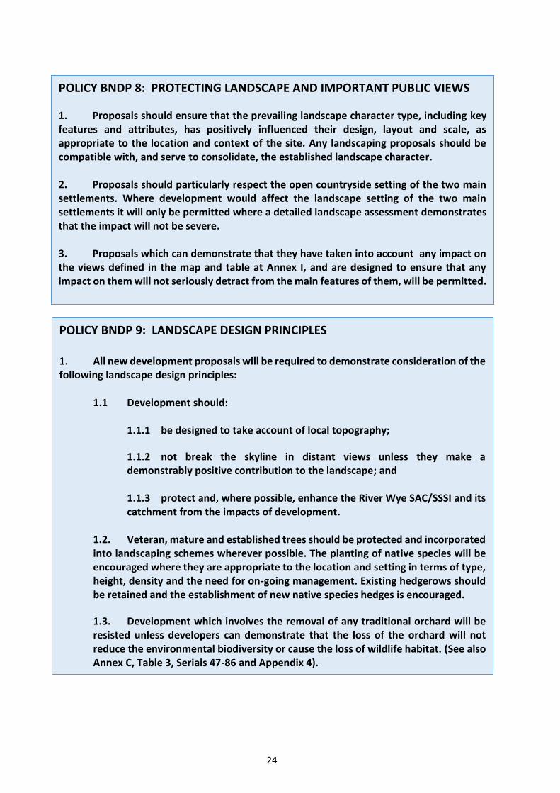
POLICY BNDP 8: PROTECTING LANDSCAPE AND IMPORTANT PUBLIC VIEWS
1. Proposals should ensure that the prevailing landscape character type, including key features and attributes, has positively influenced their design, layout and scale, as appropriate to the location and context of the site. Any landscaping proposals should be compatible with, and serve to consolidate, the established landscape character.
2. Proposals should particularly respect the open countryside setting of the two main settlements. Where development would affect the landscape setting of the two main settlements it will only be permitted where a detailed landscape assessment demonstrates that the impact will not be severe.
3. Proposals which can demonstrate that they have taken into account any impact on the views defined in the map and table at Annex I, and are designed to ensure that any impact on them will not seriously detract from the main features of them, will be permitted.
POLICY BNDP 9: LANDSCAPE DESIGN PRINCIPLES
1. All new development proposals will be required to demonstrate consideration of the following landscape design principles:
1.1 Development should:
1.1.1 be designed to take account of local topography;
1.1.2 not break the skyline in distant views unless they make a demonstrably positive contribution to the landscape; and
1.1.3 protect and, where possible, enhance the River Wye SAC/SSSI and its catchment from the impacts of development.
1.2. Veteran, mature and established trees should be protected and incorporated into landscaping schemes wherever possible. The planting of native species will be encouraged where they are appropriate to the location and setting in terms of type, height, density and the need for on-going management. Existing hedgerows should be retained and the establishment of new native species hedges is encouraged.
1.3. Development which involves the removal of any traditional orchard will be resisted unless developers can demonstrate that the loss of the orchard will not reduce the environmental biodiversity or cause the loss of wildlife habitat. (See also Annex C, Table 3, Serials 47-86 and Appendix 4).
24

Building Design
8.7 A further aspect of local distinctiveness is the characteristic building design. Although there is no single vernacular architectural style, the older buildings in the Parish, such as in the historic core of Bodenham and Bodenham Moor are typically built of local stone, with some oak timber-framed houses supplemented with later developments in brick. More modern property is in a range of materials, including brick and brick/render. Many of the dwellings erected in the Ash Grove estate area from 1968 onwards are of single-storey form. Most dwellings tend to be detached or semi-detached, although the former Arkwright Homes in the Conservation Area form a small attractive terrace. The majority of dwellings are set back generously from the highway. Such aspects contribute to the established “village" character, which also draws on natural features, open spaces and historic buildings, including two places of worship, within the settlements. These two settlements are set either side of ‘C’ class roads with a clear and close relationship to the surrounding countryside and links to the A49 and A417 highways leading to Hereford and Leominster respectively.
8.8 Planning policy supports high quality design. Herefordshire Core Strategy (Policy SD1 -Sustainable design and energy efficiency) details the wide range of factors that are assessed in this respect. For this Plan, the following policy emphasises the importance of securing a locally distinctive design approach in individual developments, which relates to and supports the existing character of the two settlements. A large majority of respondents to the Neighbourhood Plan Survey wanted to see the careful integration of new development in keeping with “village” character, with 75% supporting the use of traditional building materials. In assessing schemes under the following policy, regard will be needed to such aspects of design as layout and siting; density; means of access and enclosure, including relationship to the highway; scale and mass; height; detailing; materials; and landscaping. In particular, proposals will be required to conform to the guidance set out in Building for Life 12.
POLICY BNDP 10: PROTECTION AND ENHANCEMENT OF THE BUILT ENVIRONMENT
1. Development proposals will need to protect the valued built environment of the whole Parish. Proposals will be supported which:
1.1 take account of the significance of the local features of historic interest identified in Table 4 and the Map in Appendix 7 of Annex C and retain them where possible unless their loss is clearly necessary for the development and the benefits of the development would clearly outweigh the harm resulting from their loss;
1.2 demonstrate where appropriate and possible how they meet the standards of Building for Life 12;
1.3 preserve the character of the area by using designs and building materials for new homes which reinforce local distinctiveness;
25

1.4 are sensitively located so as to protect the built environment and are of a scale and design which ensures that any new build will respect and where possible enhance the existing built environment;
1.5 provide suitable vehicular access to the highway, off-street parking and safe pedestrian and cyclist access to local facilities; and
1.6 do not include street lighting. (See also BNDP 11).
Tranquillity and Light Pollution
8.9 Crossed by only a few main transport routes and with only six significant population centres scattered widely across broad acres of open countryside, Herefordshire is a largely tranquil county. It also benefits from some of the darkest night skies in the country, with some 88% of the County in the ‘darkest’ two categories (14). Being remote from both Hereford city and the nearest market towns of Leominster, Bromyard and Ledbury, Bodenham lies within this area of maximum tranquillity and minimum light pollution. These assets benefit the health and wellbeing of Parish residents and are clearly much valued by them. Existing street lighting in the Parish is limited to two small locations, installations which date back to the 1970s and would not find favour today. The great majority of responses to the NDP Survey indicated the wish of parishioners to preserve the rural character of their community and it is for that reason that the present major development at England’s Field will not have street lighting.
POLICY BNDP 11: TRANQUILLITY AND LIGHT POLLUTION (DARK SKIES)
1. There will be a presumption against proposals that detrimentally affect the tranquillity of the area, including through the generation of noise which would create an unacceptable nuisance to neighbours or through lighting that would result in the loss of night time dark skies.
2. Any development that requires an external lighting scheme must be designed to ensure that light spillage beyond the boundary of the property is kept to a minimum.
Open Spaces
8.10 The open spaces in and around the existing settlements greatly contribute to their rural character and are much valued. The Core Strategy (Policies LD1 - landscape and townscape and
14. See http://www.cpre.org.uk/resources/countryside/dark-skies/item/4311-night-blight-2016-mapping-england-s-light-pollution-and-dark-skies , which ranks Herefordshire as the darkest county in the country based on average light levels; it has “the third highest amount of pristine night skies, with 60% in the darkest category; and 88% when combined with the next darkest category.”
26

LD3 - green infrastructure) provide a strategic direction, but it falls to this Plan to identify specific areas for protection. 77% of the Neighbourhood Plan Survey responses confirm the importance of this issue, with many residents wanting the Plan to identify and protect open spaces.
8.11 Parcels of land in the Parish were identified and protected in the former UDP as important open areas. In Bodenham Moor these are located:
• Off the C1125 and bounded by Ash Grove Road and Brockington Road known as ‘The Green’ (15) (part of which is a children’s play area);
• Adjacent to, and to the North-East of, the GP surgery; and
• Adjacent to the Parish Hall (part of which contains tennis courts, part provides car parking for the Hall, and part remains in agricultural use).
8.12 The protection of the first two of these spaces is continued in this Plan, using the Local Green Space designation introduced by the National Planning Policy Framework (16). The same designation has been approved for the parcel of land in Bodenham on which the War Memorial, the Well and the remains of the Market Cross stand, but not for the land adjacent to the Parish Hall or for the only other land owned by the Parish Council, the car park opposite St. Michael’s Primary School.
8.13 The field lying East of the C1125 and bounded to the North by Chapel Lane, commonly known locally as ‘Shuker’s Field’, emerged from the Neighbourhood Plan Survey as deserving protection from built development. It offers relief to the mainly built-up form of Bodenham Moor on this principal road frontage and plays an important role in contributing to the agricultural character and rural sense of place. Indeed, the strength of local feeling is such that a recent proposal to develop it for residential use drew over 250 letters of objection from residents. It does not, however, qualify for designation as a Local Green Space.
8.14 The 1.70ha field parcel in Bodenham opposite the War Memorial at the junction of the C1121 and Church Lane (U94029) to the North of Aisling House is particularly sensitive, lying at the historic core of the settlement in close proximity to the medieval Market Cross, Covered Well and several listed buildings. The open nature of the field relieves the otherwise built form of the streetscene in this location and contributes in large measure to the character and local distinctiveness of the Bodenham Conservation Area. Neighbourhood Plan Survey respondents gave strong support to the retention of the area as a valued open space amenity critical in maintaining the rural character of the area and its designation as a Local Green Space has been approved.
8.15 There are three areas of registered Common Land in the Parish – Maund Bryan, Upper Maund with Whitchurch Maund, and Common Marsh adjacent to Rowberry Lane - that are protected and registered under separate legislation (17) and thus do not require any additional protection under this Plan.
8.16 Lady Close Orchard and Bodenham Lake are in the ownership of Herefordshire Council, but are leased to a community interest company (CIC) formed by Herefordshire Wildlife Trust and New Leaf which is responsible for their day-to-day management. In the Neighbourhood Plan
15. This is designated as a Public Open Space (Registration Nos. HE37364 and HE37365). 16. National Planning Policy Framework, paras. 76 and 77. 17. Commons Registration Act 1965 Sects. 8(3) & 9.
27

Survey Bodenham Lake was the area most quoted as being of special importance as a public open space of great sensitivity and one which makes a major contribution to the character and appearance of the Bodenham Conservation Area and the wider Parish. Although Lady Close Orchard and Bodenham Lake do not qualify for consideration as a Local Green Space, they are designated as a Local Wildlife Site and this Plan seeks to ensure further protection conferred on them by having them eventually approved as a Local Nature Reserve.
8.17 A list of the areas identified by this Plan as Local Green Spaces is contained in Annex C.
POLICY BNDP 12: OPEN SPACES
1. Proposals for development on Local Green Spaces, as listed in Annex C and shown on the Maps at Appendix 1 and Appendix 2 to Annex C, will only be supported if they are directly related to the retention, management or improvement of the green space or there is a very special circumstance; for example, the development is essential to meet specific necessary utility infrastructure needs and no alternative feasible site is available.
9. RENEWABLE ENERGY
9.1 The Neighbourhood Plan Survey sought local residents’ views on the possible provision of solar panels, wind turbines, hydropower, or ground source heat pumps as energy sources for private residences, for the community, and for commercial enterprises. Various methods of small scale generation were supported, notably solar panels and capturing natural heat in the ground, but, because of their visual obtrusiveness on the landscape and the impact of their noise on the amenity of neighbours, this was not true of wind turbines. Large systems, such as solar farms, biomass plants, anaerobic digesters and wind turbines were not favoured. Renewable energy is covered by the Core Strategy (Policies SD1 - Sustainable design and energy efficiency and SD2 -Renewable and low-carbon energy), which provide a positive framework for such proposals. In particular, community-led micro-generation schemes proposed in neighbourhood plans will be supported where they meet the Core Strategy’s policies. It is for this Plan to define more precisely what renewable energy schemes are, and are not, acceptable.
POLICY BNDP 13: RENEWABLE ENERGY
1. Subject to their complying with the other relevant policies in this Plan, small scale proposals to generate energy from renewable sources for the direct benefit of local community facilities and/or individual residences will be encouraged, except those relying on wind as the energy source which will not be supported.
2. To be supported these renewable energy proposals must demonstrate that they have regard to their impact on local amenity and landscape in terms of appropriate siting, type and scale. They must protect:
2.1 the quality and character of the landscape; and
28

2.2 local heritage such as archaeological sites, historic buildings and non-designated assets, including their settings; and
2.3 sites of nature conservation importance or biodiversity; and
2.4 local and residential amenity.
10 DELIVERING THE PLAN
10.1 This Plan is a long-term planning document, which will be implemented in the period to 2031 primarily via decisions on planning applications, but also by the actions and investments of other agencies and parties. In delivering the sustainable development of the Parish, the Parish Council will seek to implement and deliver the Plan through each of its four Plan themes as follows:
10.1.1 Settlement Boundaries. The Parish Council will work with Herefordshire Council to secure decisions on planning applications which are in accordance with the Plan. Decisions in favour of development which meets Plan objectives and policies, including the delivery of housing growth, will be supported and proposals which would conflict with the Plan, particularly those which adversely affect the setting and/or character of the two ‘village’ settlements, will be resisted.
10.1.2 Housing. The Parish Council will work with Herefordshire Council, landowners, developers, social housing providers and the community to secure housing growth as set out in the Plan.
10.1.3 Jobs and Local Services. The Parish Council will:
• Work with businesses to improve local employment opportunities in line with the objectives and policies of the Plan.
• Work with Herefordshire Council and local organisations to protect, retain and enhance community facilities.
10.1.4 Open Spaces and the Environment. The Parish Council will:
• Work with Herefordshire Council to protect and enhance landscape and townscape throughout the Parish through appropriate decision-making on planning applications.
• Protect valued open spaces throughout the Parish as Local Green Spaces.
• Seek the use of infrastructure monies, including developer contributions, to meet needs, including for the reduction of flood risk, the enhancement of open space, the improvement of cycle and walking routes, and traffic speed monitoring and enforcement.
29

11. REVIEWING AND MONITORING THE PLAN
11.1 This NDP covers the period until 2031. Inevitably within this period there will be changes, including those relating to:
• The Parish’s demographics, possibly with an increase in the proportion of older people.
• National planning policies.
• The housing market, reflected in movements in both the price of new and older properties and the market value of land.
• The demand for local housing, particularly from younger members of the community and the needs of elderly members.
• Small businesses and farming, which may affect the demand for other types of building and the availability of land.
11.2 These and other unforeseen developments make it essential that this Plan is kept up to date. To ensure that its details, particularly in terms of housing, are still relevant and that the Plan continues to serve the best interests of the Parish, it will be formally reviewed by the Parish Council five years after its adoption.
30

Annex A
NATIONAL AND LOCAL PLANNING POLICIES
1. A wide range of planning policies already apply to the Bodenham Neighbourhood Area courtesy of the National Planning Policy Framework and county-level plans. The principal documents and their provisions are summarised below.
National Planning Policy Framework
2. The Framework sets out national policy statements on the full range of planning matters, including both development and environmental protection. Relevant chapters are:
• Supporting a prosperous rural economy (Chapter 3)
• Delivering a wide choice of high quality homes (6)
• Requiring good design (7)
• Promoting healthy communities (8)
• Meeting the challenge of flooding (10)
• Conserving and enhancing the natural and historic environment (11, 12)
3. The Framework is supported by Planning Practice Guidance which sets out more details on how the national policies should be implemented, for instance with regard to flood risk.
Herefordshire Unitary Development Plan 2007
4. Though the bulk of the Unitary Development Plan policies have been superseded by those set out in the Local Plan, the following policy remains in force:
• M5, Safeguarding mineral reserves
Herefordshire Local Plan 2015
5. This sets out a county-level spatial strategy and policies on a wide range of planning matters, with the following of particular relevance and importance to the Neighbourhood Plan:
• SS1 Presumption in favour of sustainable development
• RA1 Rural housing distribution
• RA2 Housing in settlements outside Hereford and the market towns
• RA3 Herefordshire’s countryside • RA4 Agricultural, forestry and rural enterprise dwellings
• RA5 Re-use of rural buildings
• RA6 Rural economy
• H1 Affordable housing
• H3 Ensuring a range and mix of housing types
• SC1 Social and community facilities
A - 31

• OS1 Requirement for open space, sports and recreational facilities
• OS2 Meeting open space, sports and recreation needs
• MT1 Traffic management, highway safety and promoting active travel
• E3 Home working
• E4 Tourism
• LD1 Landscape and townscape
• LD2 Biodiversity and geodiversity • LD3 Green infrastructure
• LD4 Historic environment and heritage assets
• SD1 Sustainable design and energy efficiency
• SD2 Renewable energy
• SD3 Sustainable water management and water resources
• SD4 Wastewater treatment and river water quality
• ID1 Infrastructure delivery
A - 32

Annex B
EVIDENCE BASE
1. The following planning policy documents, reports and survey material have been used in drawing up the draft Neighbourhood Plan. They are all available via the Bodenham Parish Website at http://www.bodenhamparish.org.uk/evidencebase.asp , but in almost all cases direct links are provided below.
2. National and County-level Evidence
• Department for Communities and Local Government, National Planning Policy Framework and Planning Practice Guidance. http://planningguidance.communities.gov.uk/
• Herefordshire Council’s Unitary Development Plan, 2007. https://www.herefordshire.gov.uk/planning-and-building-control/planning-policy/unitary-development-plan
• Herefordshire Council’s Rural Housing background paper to Core Strategy, 2013. https://www.herefordshire.gov.uk/downloads/file/1705/rural_housing_background_pap er_march_2013
• Herefordshire Council’s Local Housing Market Assessment, 2013. https://www.herefordshire.gov.uk/downloads/file/1644/local_housing_market_assessm ent_2013
• Herefordshire Council’s Landscape Character Assessment, Supplementary Planning Guidance, 2004 updated 2009. https://www.herefordshire.gov.uk/downloads/file/2069/landscape_character_assessme nt_for_herefordshire
• Natural England, National Character Area profile 100 (Herefordshire Lowlands) http://publications.naturalengland.org.uk/publication/4827527503675392
• Natural England, National Character Area profile 101 (Herefordshire Plateau) http://publications.naturalengland.org.uk/publication/5006583801053184
• Environment Agency and Natural England, River Wye SAC, Nutrient Management Plan, Evidence base and options appraisal, Action Plan, 2014. https://www.gov.uk/government/uploads/system/uploads/attachment_data/file/37584 7/Wye_SAC_NMP_Action_Plan.pdf
• Herefordshire Council’s Strategic Housing Land Availability Assessment 2009. https://www.herefordshire.gov.uk/downloads/download/239/strategic_housing_land_a vailability_assessment_2009_planning_documents
B - 1

• Herefordshire Council’s Strategic Housing Land Availability Assessment 2009 for Bodenham Moor. https://www.herefordshire.gov.uk/downloads/file/2769/bodenham_the_moor_shlaa_as sessment
• Herefordshire Council’s Strategic Housing Land Availability Assessment 2011. https://www.herefordshire.gov.uk/downloads/download/241/strategic_housing_land_a vailability_assessment_2011_planning_documents
• Herefordshire Council’s Strategic Housing Land Availability Assessment 2012 https://www.herefordshire.gov.uk/downloads/download/596/strategic_housing_land_a vailability_assessment_2012_planning_documents
• Herefordshire Council’s Strategic Housing Land Availability Assessment 2015 https://www.herefordshire.gov.uk/downloads/download/181/strategic_housing_land_a vailability_assessment_2015
• Herefordshire Council’s Strategic Housing Land Availability Assessment 2015 for Bodenham Moor https://www.herefordshire.gov.uk/downloads/file/2552/bodenham_moor
• Herefordshire Council’s Strategic Housing Land Availability Assessment 2015 for Bodenham https://www.herefordshire.gov.uk/download/downloads/id/2553/bodenham.pdf
• Herefordshire Council’s Strategic Intelligence Team, Local Housing Needs Survey for Bodenham Parish June 2014. https://www.herefordshire.gov.uk/download/downloads/id/4921/bodenham_2014.pdf
• Herefordshire Council’s Local Plan, Core Strategy 2011-2031, Adopted Nov. 2015. https://www.herefordshire.gov.uk/downloads/download/123/adopted_core_strategy
3. Pre-Draft Plan Documents
• Neighbourhood Area Application Form. https://myaccount.herefordshire.gov.uk/media/6287298/bodenham_application_form.p df
• Neighbourhood Area Boundary Map. https://myaccount.herefordshire.gov.uk/media/6287303/bodenham_map.pdf
• Neighbourhood Area Decision Document. https://myaccount.herefordshire.gov.uk/media/6586968/bodenham_decision_documen t.pdf
B - 2

4. Regulation 14 Consultation
• Bodenham Neighbourhood Development Plan Draft for Regulation 14 Consultation. http://www.bodenhamparish.org.uk/pdf/neighbourhood-development-plan-11-31.pdf
5. Regulation 16 Consultation
• Regulation 16 Draft Neighbourhood Development Plan. Available on Herefordshire Council’s website at https://myaccount.herefordshire.gov.uk/bodenham and on the Bodenham Parish website at http://www.bodenhamparish.org.uk/evidencebase.asp .
• Consultation Statement. http://www.bodenhamparish.org.uk/pdf/ndp2017/NDP-Reg-16.pdf
o RPS response to Regulation 14 Consultation (Addendum to the Consultation Statement). http://www.bodenhamparish.org.uk/pdf/ndp2017/Reg-14-RPS-Response.pdf
• Habitats Regulations Assessment for Bodenham Neighbourhood Area. http://www.alphadocs.co.uk/bpc/pcd/Bodenham_HRA_June2016.pdf
• Addendum to Habitats Regulations Assessment for Bodenham Neighbourhood Area. http://www.alphadocs.co.uk/bpc/pcd/Bodenham_HRA_Addendum.pdf
• Strategic Environmental Assessment for Bodenham Neighbourhood Area. http://www.bodenhamparish.org.uk/pdf/Bodenham-Env-Report-June16.pdf
• Basic Condition Statement. http://www.alphadocs.co.uk/bpc/pcd/BodenhamNDPBasicConditionsStatementSept ember2017 (Rev).pdf
• Bodenham Parish Policies Map. http://www.alphadocs.co.uk/bpc/pcd/Bodenham_parish_Policies_Map.pdf
• Bodenham Moor Village Policies Map. http://www.alphadocs.co.uk/bpc/pcd/Bodenham_Moor_village_Policies_Map.pdf
• Bodenham Village Policies Map. http://www.alphadocs.co.uk/bpc/pcd/Bodenham_village_Policies_Map.pdf
6. Parish and Local Level Evidence
6.1 The documents listed below provide evidence of community involvement in the development of Bodenham’s Neighbourhood Development Plan and/ or data supporting statements in the Plan, for example, those relating to housing growth:
B - 3

6.2 Bodenham Parish Plan. The initial basis for the Neighbourhood Plan is the Parish Plan published in October 2012, which was itself based on the outcome of a survey of the views of residents conducted in October 2010 by means of two questionnaires – one to all adults in the Parish and the other to all those under 18. The responses to each questionnaire were analysed by Herefordshire Council’s Research Team who produced summaries of both sets of data and separate reports on each:
• Bodenham Parish Plan http://www.alphadocs.co.uk/bpc/noticeboard/CLP-ActionPlan(Final).pdf
• Parish Plan Survey - Adult Questionnaire http://www.alphadocs.co.uk/bpc/pcd/Parish Plan - Adult Questionnaire (Final).pdf
• Parish Plan Survey - Under 18 Questionnaire http://www.alphadocs.co.uk/bpc/pcd/Parish Plan - Under 18 Questionnaire (Final).pdf
• Parish Plan - Responses to Adults Questionnaire - Data Summary http://www.alphadocs.co.uk/bpc/pcd/Bodenham ADULTS Data summary.xlsx
• Parish Plan - Responses to Under 18s Questionnaire - Data Summary http://www.alphadocs.co.uk/bpc/pcd/Bodenham CYP Data summary.xlsx
• Bodenham Parish Plan Adult Questionnaire Report March 2011 http://www.alphadocs.co.uk/bpc/pcd/Bodenham Parish Plan final Report IGv2 (Rev2A).pdf
• Bodenham Parish Plan Young People’s Questionnaire Report March 2011 http://www.alphadocs.co.uk/bpc/pcd/Bodenham Parish Plan final CYP Questionnaire Report IG (2)(Rev).pdf
6.3 Neighbourhood Plan Survey. A further survey of all adult residents in the Parish was carried out in September/ October 2014 specifically to provide input to the Neighbourhood Plan. To avoid any possibility of bias the responses to the Survey were independently analysed by Data Orchard, who reported their findings in November 2014. These were then further distilled by the Neighbourhood Plan Steering Group into a ‘Summary and Conclusions’ document, which was discussed and approved at a public meeting in the Parish Hall on 10 March 2015.
• Neighbourhood Plan Survey Questionnaire 2014 http://www.alphadocs.co.uk/bpc/pcd/Neighbourhood Plan - Questionnaire (Final2).pdf
• Data Orchard Report on responses to the Neighbourhood Plan Survey 2015 http://www.bodenhamparish.org.uk/pdf/Neighbourhood_Plan_-_Data_Orchard_Analysis_Report.pdf
B - 4

• Agreed Summary and Conclusions from the Data Orchard Report 2015 http://www.alphadocs.co.uk/bpc/pcd/Neighbourhood Plan - Basic Analysis -Summary and Conclusions (Rev).pdf
7. Other Supporting Documents
• Study of Potential Housing Land in Bodenham Neighbourhood Area. http://www.bodenhamparish.org.uk/pdf/ndp2017/Potential-Housing-Land.pdf
B - 5

Annex C
KEY ENVIRONMENTAL AND OTHER ASSETS PROTECTED FROM DEVELOPMENT UNDER THIS PLAN
TABLE 1 – LOCAL GREEN SPACES IN BODENHAM MOOR (For locations see the maps at Appendices 1 and 2 to this Annex)
Ser Item Category
Proximity to
Community Centre
Special Qualities/ Local Significance and
Character
Approximate Area
Notes
(a) (b) (c) (d) (e) (f) (g)
1. The grassed space to the North-East of the GP Surgery
Local Green Space
50m Essential to the open character of the heart of
0.1 hectares (0.3 acres)
Owned by Herefordshire Council and defined as a public open space. It was
in Bodenham Moor bounded by the C1125 and Ash Grove Road
the village previously ‘protected’ under UDP Policy HBA9.
2. The Village Green in Local Green N/A Essential to the open 0.4 hectares Owned by Herefordshire Council and Bodenham Moor bounded by Space character of the heart of (1.0 acres) defined as a public open space. It was the C1125, Ash Grove Road and Brockington Road
the village previously ‘protected’ under UDP Policy RST4.(18)
18. The County Land Agent advised in letter of 9/4/10 to the Parish Clerk that the land is designated as a “Public Open Space”. Sch. 5A Amendment to Open Spaces Act 1906 (c.25) -23 June 2003: Column GC32. Registration Numbers HE37364 & HE 37365.
C - 1

TABLE 2 - LOCAL GREEN SPACES IN BODENHAM (For locations see the maps at Appendices 1 and 2 to this Annex)
Ser Item Category
Proximity to
Community Centre
Special Qualities/ Local Significance and
Character
Approximate Area
Notes
(a) (b) (c) (d) (e) (f) (g)
3. The Village Green on which are sited the War Memorial, Well and the Market Cross.
Local Green Space
At the centre
Essential to the Parish’s heritage and to the open character of the heart of the village.
200m2 Unit No. VG.9 in the Land Section of the Register of Town or Village Greens maintained by Herefordshire County Council. Ownership is vested in Bodenham Parish Council. (19)
4. The field opposite the War Memorial at the junction of the C1121 and Church Lane (U94029) and to the north of Aisling House.
Local Green Space
20m Key to preserving the rural character of the village and the eastern part of the Conservation Area.
1.7 hectares (4.2 acres)
5. Spare
TABLE 3 - OTHER ASSETS
Where relevant, assets in the following table are listed in the order in which they appear in Appendix 8 to Herefordshire Council’s Core Strategy and their locations in the Parish are shown in the maps contained in Appendices 3 and 4 to this Annex.
Ser ID
Item Category Map at
Appendix Notes
(a) (b) (c) (d) (e) (f)
6. The Parish Hall with its car park, tennis courts and Field Parcel to the East
Sole publicly owned social and recreational facility in the Parish
- The Tennis Courts plot was previously ‘protected’ by UDP Policy RST4.
19. Under the Commons Registration Act 1965, Section 8(3) by Decision Notice 15/U/18 dated 27 February 1973 issued by the Commons Commissioner. C - 2

Ser ID
Item Category Map at
Appendix Notes
(a) (b) (c) (d) (e) (f)
7. Lady Close Orchard and Bodenham Lake (GR523511)
Local Wildlife Site and recreational facility. Bodenham Lake is also listed as an Asset of Community Value
3 The entire land parcel is owned by Herefordshire Council and was leased on 15 March 2016 to a community interest company (CIC) formed by Herefordshire Wildlife Trust and New Leaf Sustainable Development Ltd.
8. Bodenham Conservation Area
Conservation Area 1 & 2 An area of special architectural and historic interest, the character and appearance of which it is desirable to preserve and enhance. Listed in Herefordshire Council’s Core Strategy, Appendix 8a (Page 1).
9. Bodenham Manor Unregistered Park and Garden
4 GR 52677-51433. Listed in Herefordshire Council’s Core Strategy, Appendix 8d (Page 15). Partly accessible on PROW.
10. Broadfield Court Unregistered Park and Garden
4 Off C1113, Bowley Lane. GR 54836-52794. Listed in Herefordshire Council’s Core Strategy, Appendix 8d (Page 15).
11. The Vern Unregistered Park and Garden
4 GR 351955–250848. Listed in Herefordshire Council’s Core Strategy, Appendix 8d (Page 17).
12. Vennwood Unregistered Park and Garden
4 GR 354773–249023. Listed in Herefordshire Council’s Core Strategy, Appendix 8d (Page 18).
13. SAC_002 River Lugg Special Area of Conservation (SAC)
3 GR 544912 – 230429. Part of River Wye SAC_002. Listed in Herefordshire Council’s Core Strategy, Appendix 8e (Page 19).
14. SSSI_023 Dinmore Hill Woods (Part)
Site of Special Scientific Interest (SSSI)
3 GR 512516. Date 18/02/1986. Listed in Herefordshire Council’s Core Strategy, Appendix 8f (Page 20).
15. SSSI_033 Hill Hole Dingle (Part) Site of Special Scientific Interest (SSSI)
3 GR 537540. Date 31/07/1987. Listed in Herefordshire Council’s Core Strategy, Appendix 8f (Page 20).
16. SSSI_059 A & B
River Lugg (Part) Site of Special Scientific Interest (SSSI)
3 GR 173751 to 565372. Date 02/02/1985. Listed in Herefordshire Council’s Core Strategy, Appendix 8f (Page 21).
C - 3

Ser ID
Item Category Map at
Appendix Notes
(a) (b) (c) (d) (e) (f)
17. LNR_001 Dinmore Hill Woods (Queenswood) (Part)
Local Nature Reserve (LNR)
3 GR 365048-250845. Listed in Herefordshire Council’s Core Strategy, Appendix 8f (Page 24).
18. SO54/006 Venn's Wood Local Wildlife Site (LWS) 3 GR 550491. Listed in Herefordshire Council’s Core Strategy, Appendix 8i (Page 37).
19. SO54/007 Upper Maund and Whitchurch Commons (20)
Common and Local Wildlife Site (LWS)
2 &3 GR 562494-563491. Register Unit CL.30. Listed in Herefordshire Council’s Core Strategy, Appendix 8i (Page 37). Approximate area 3.1 hectares (7.7 acres).
20. SO54/008 Maund Common Common and Local Wildlife Site (LWS)
2 & 3 GR 561499- 560500. Register Unit CL.2. Listed in Herefordshire Council’s Core Strategy, Appendix 8i (Page 37). Approximate area 3.2 hectares (7.9 acres).
21. Common Marsh Common 2 Fronting on Rowberry Lane and adjacent to the western boundary of Blue Cedar Cottage. Register Unit CL.90 (GR547498). Approximate area 0.4 hectares (0.9 acres).
22. SO55/003 Dinmore Hill and adjoining woodland
Local Wildlife Site (LWS) 3 GR 507513. Listed in Herefordshire Council’s Core Strategy, Appendix 8i (Page 37).
23. SO55/004 River Lugg Local Wildlife Site (LWS) 3 GR 537519. Listed in Herefordshire Council’s Core Strategy, Appendix 8i (Page 37).
24. SO55/007 Gravel pits at Bodenham
Local Wildlife Site (LWS) 3 GR 523511. Listed in Herefordshire Council’s Core Strategy, Appendix 8i (Page 38).
25. SO55/010 Dorlas Coppice Local Wildlife Site (LWS) 3 GR 543524. Listed in Herefordshire Council’s Core Strategy, Appendix 8i (Page 38).
20. Registered under the Commons Registration Act 1965, Sect. 9. Decision Notice 15/U/19, 15/U/20 & 15/U/21 dated 16 March 1973 issued by the Commons Commissioner.
C - 4

Ser ID
Item Category Map at
Appendix Notes
(a) (b) (c) (d) (e) (f)
26. SO55/013 Dudale's Wood and Old Coppice
Local Wildlife Site (LWS) 3 GR 562521. Listed in Herefordshire Council’s Core Strategy, Appendix 8i (Page 38).
27. Bodenham Tufa Falls Local Geological Site 4 Off the C1120 (GR 517513). Listed in Herefordshire Council’s Core Strategy, Appendix 8j (Page 45).
28. Dudale’s Hope Valley Local Geological Site 4 Off the A417 (GR 566516). Listed in Herefordshire Council’s Core Strategy, Appendix 8j (Page 45). No public access.
29. 1504163 Breaks Coppice Ancient & Semi-Natural Woodland
4 GR 549531. Listed in Herefordshire Council’s Core Strategy, Appendix 8k (Page 53)
30. 1106208 Combs Hill Wood (part)
Ancient & Semi-Natural Woodland
4 GR 573503. Listed in Herefordshire Council’s Core Strategy, Appendix 8k (Page 57)
31. 1106190 Dorlas Coppice Ancient & Semi-Natural Woodland
4 Off C1113, Bowley Lane. GR 543524. Listed in Herefordshire Council’s Core Strategy, Appendix 8k (Page 61). No public access.
32. 1106203 Dudale’s Wood Ancient & Semi-Natural Woodland
4 GR 567522. Listed in Herefordshire Council’s Core Strategy, Appendix 8k (Page 62).
33. 1106203 Dudale’s Wood Ancient Replanted Woodland
4 GR 568522. Listed in Herefordshire Council’s Core Strategy, Appendix 8k (Page 62).
34. 1106189 Hill Hole Dingle Ancient Replanted Woodland
4 GR 529537. Listed in Herefordshire Council’s Core Strategy, Appendix 8k (Page 67).
35. 1106189 Hill Hole Dingle Ancient & Semi-Natural Woodland
4 GR 534537. Listed in Herefordshire Council’s Core Strategy, Appendix 8k (Page 68).
36. 1504333 Holbatch Coppice Ancient Replanted Woodland
4 GR 554482. Listed in Herefordshire Council’s Core Strategy, Appendix 8k (Page 68).
C - 5

Ser ID
Item Category Map at
Appendix Notes
(a) (b) (c) (d) (e) (f)
37. 1504164 Lower Yeald Wood Ancient Replanted Woodland
4 GR 554527. Listed in Herefordshire Council’s Core Strategy, Appendix 8k (Page 73).
38. 1504166 North Hill Grove Ancient Replanted Woodland
4 GR 557513. Listed in Herefordshire Council’s Core Strategy, Appendix 8k (Page 76).
39. 1504165 Open or Round Coppice
Ancient & Semi-Natural Woodland
4 GR 552517. Listed in Herefordshire Council’s Core Strategy, Appendix 8k (Page 77).
40. 1106188 The Rookery Ancient Replanted Woodland
4 GR 525521. Listed in Herefordshire Council’s Core Strategy, Appendix 8k (Page 86).
41. 1106177 Venns Wood Ancient Replanted Woodland
4 GR 550492. Listed in Herefordshire Council’s Core Strategy, Appendix 8k (Page 88).
42. 1106177 Venns Wood Ancient & Semi-Natural Woodland
4 GR 550491. Listed in Herefordshire Council’s Core Strategy, Appendix 8k (Page 88).
43. 1414439 No name supplied Ancient & Semi-Natural Woodland
4 GR 562521. Listed in Herefordshire Council’s Core Strategy, Appendix 8k (Page 92).
44. 1414429 No name supplied Ancient & Semi-Natural Woodland
4 GR 571509. Listed in Herefordshire Council’s Core Strategy, Appendix 8k (Page 93).
45. 1414431 No name supplied Ancient & Semi-Natural Woodland
4 GR 559519. Listed in Herefordshire Council’s Core Strategy, Appendix 8k (Page 93).
46. 1414420 No name supplied Ancient & Semi-Natural Woodland
4 GR 570503. Listed in Herefordshire Council’s Core Strategy, Appendix 8k (Page 95).
47. HERE1519 No name supplied Traditional Orchard 4 GR 5482 4982. Note 1.
48. HERE1520 No name supplied Traditional Orchard 4 GR 5446 4988. Note 1.
49. HERE1521 No name supplied Traditional Orchard 4 GR 5440 4991. Note 1.
C - 6

Ser ID
Item Category Map at
Appendix Notes
(a) (b) (c) (d) (e) (f)
50. HERE1522 No name supplied Traditional Orchard 4 GR 5441 4997. Note 1.
51. HERE1565 No name supplied Traditional Orchard 4 GR 5287 5095. Note 1.
52. HERE1566 No name supplied Traditional Orchard 4 GR 5295 5130. Note 1
53. HERE1570 No name supplied Traditional Orchard 4 GR 5360 5019. Note 1.
54. HERE1571 No name supplied Traditional Orchard 4 GR 5334 5028. Note 1.
55. HERE1572 No name supplied Traditional Orchard 4 GR 5377 5049. Note 1.
56. HERE1573 No name supplied Traditional Orchard 4 GR 5309 5096. Note 1.
57. HERE1574 No name supplied Traditional Orchard 4 GR 5343 5115. Note 1.
58. HERE1575 No name supplied Traditional Orchard 4 GR 5339 5115. Note 1.
59. HERE1576 No name supplied Traditional Orchard 4 GR 5313 5119. Note 1.
60. HERE1578 No name supplied Traditional Orchard 4 GR 5326 5126. Note 1.
61. HERE1580 No name supplied Traditional Orchard 4 GR 5379 5301. Note 1.
62. HERE1581 No name supplied Traditional Orchard 4 GR 5452 5074. Note 1.
63. HERE1583 No name supplied Traditional Orchard 4 GR 5399 5107. Note 1.
64. HERE1584 No name supplied Traditional Orchard 4 GR 5431 5131. Note 1.
65. HERE1585 No name supplied Traditional Orchard 4 GR 5425 5155. Note 1.
66. HERE1586 No name supplied Traditional Orchard 4 GR 5419 5160. Note 1.
67. HERE1587 No name supplied Traditional Orchard 4 GR 5405 5152. Note 1.
68. HERE1589 No name supplied Traditional Orchard 4 GR 5402 5259. Note 1.
69. HERE1642 No name supplied Traditional Orchard 4 GR 5526 4876. Note 1.
70. HERE1644 No name supplied Traditional Orchard 4 GR 5532 4895. Note 1.
71. HERE1646 No name supplied Traditional Orchard 4 GR 5523 4991. Note 1.
72. HERE1647 No name supplied Traditional Orchard 4 GR 5597 4997. Note 1.
73. HERE1651 No name supplied Traditional Orchard 4 GR 5639 4923. Note 1.
74. HERE1653 No name supplied Traditional Orchard 4 GR 5629 4985. Note 1.
75. HERE1655 No name supplied Traditional Orchard 4 GR 5723 4954. Note 1.
76. HERE1679 No name supplied Traditional Orchard 4 GR 5546 5030. Note 1.
77. HERE1680 No name supplied Traditional Orchard 4 GR 5526 5048. Note 1.
78. HERE1681 No name supplied Traditional Orchard 4 GR 5529 5054. Note 1.
79. HERE1682 No name supplied Traditional Orchard 4 GR 5523 5065. Note 1.
80. HERE1683 No name supplied Traditional Orchard 4 GR 5591 5063. Note 1.
81. HERE2923 No name supplied Traditional Orchard 4 GR 5525 4893. Note 1.
82. HERE3085 No name supplied Traditional Orchard 4 GR 5275 5127. Note 1
C - 7

Ser ID
Item Category Map at
Appendix Notes
(a) (b) (c) (d) (e) (f)
83. HERE3269 No name supplied Traditional Orchard 4 GR5597 5108. Note 1.
84. HERE3502 No name supplied Traditional Orchard 4 GR 5698 4900. Note 1.
85. HERE3848 No name supplied Traditional Orchard 4 GR 5518 5049. Note 1.
86. HERE3916 No name supplied Traditional Orchard 4 GR 5763 4900. Note 1.
Notes 1. Source: Natural England Dataset for Traditional Orchards at http://environment.data.gov.uk/ds/catalogue/#/catalogue .
TABLE 4 - LISTED BUILDINGS IN BODENHAM PARISH
The description of each of the assets in the following table can be found on the britishlistedbuildings.co.uk website by clicking on the name of the asset in column (b). The locations of the listed buildings within the Parish are shown in the maps contained in Appendices 5 and 6 to this Annex.
Ser Building Grade Remarks
(a) (b) (c) (d) 1. Bank House II 2. Barn About 12 Yards South of Maund Farmhouse II 3. Barn About 20 Yards North of Broadfield Court II 4. Barn and Adjoining Shelter Sheds About 30 Yards North East of Broadfield Court II 5. Barn and Adjoining Stable and Shelter Sheds About 30 Yards North West of
Bodenham Court Farmhouse II
6. Barn and Stable Adjoining the Vern to the South East II 7. Bodenham Bridge II Millcroft Road (C1121) 8. Bodenham Court Farmhouse II 9. Bodenham Hall II 10. Bower Cottage II 11. Broadfield Court II* 12. Brook House II 13. Broom Cottage II Chapel Lane,
C - 8

Ser Building Grade Remarks
(a) (b) (c) (d) 14. Church of St Michael and All Angels II* 1 Church Walk, Bodenham 15. Cider Mill, Granary and Hop Kiln Adjoining Broadfield Court to the East II 16. Corduroy II 17. Cowhouse and Linhay Adjoining Wood House Farmhouse and Granary to the West II 18. Cowhouse and Stables About 20 Yards South West of Bodenham Court Farmhouse II 19. Devereux Court II Church Walk 20. Dewdale's Hope Farmhouse Dudale's Hope II 21. Dovecote About 20 Yards East South East of the Pigeon House II 22. Englands Gate Inn II Also registered as an Asset of
Community Value 23. Field House II Bowley Lane 24. Halfway House II 25. Houghton Court II 26. Isle of Rhea Cottage II A417 27. Lower Broadfield and Adjoining Outbuilding II 28. Maund Court II A417 29. Maund Farmhouse II A417 30. Moor Farmhouse II The Moor 31. Outbuilding About 20 Yards East of Bodenham Court Farmhouse II 32. Outbuilding About 20 Yards South East of Maund Farmhouse II 33. Outbuilding About One Yard South West of Englands Gate Inn II Millcroft Road 34. Pease Green Cottage II Church Walk 35. Remains of Churchyard Cross About 10 Yards South East of the Church of St Michael
and All Angels II Church Walk
36. Remains of Market Cross About 30 Yards South West of Well Cottage II 37. Rose Cottage II Omega Place 38. Stables About Five Yards North East of Englands Gate Inn II A417 39. Stock Tree Cottage II Bowley Lane 40. Tan-Y-Bryn II Church Walk 41. The Haven II Chapel Lane
C - 9

Ser Building Grade Remarks
(a) (b) (c) (d) 42. The Ketch House and Adjoining Stables II A417 43. The Old Toll House II A417 44. The Vern II 45. The Weir House and Flanking Walls II 46. The White House II 47. Well Cottage II 48. Wood House Farmhouse and Adjoining Granary II
TABLE 5 - UNLISTED ASSETS VALUED BY THE LOCAL COMMUNITY
Ser Map ID
Asset Grid Reference
(a) (b) (c) (d)
BODENHAM MOOR
1. A Bodenham Chapel. SO5415 5058
2. B The war grave in front of the Chapel. SO5451 5057
3. C The stone milestone near the former police station on The Moor (C1125) SO5451 5000
4. D The telephone kiosk (now used as a lending library) at the junction of the C1121 and C1125. SO5438 5122
5. E The pollarded Black Poplar (Populus nigra betulifolia) adjacent to The Moor Brook pumping station. SO5447 5034
6. F The ‘Huddle of Bullocks’ sculpture on the Village Green. SO5443 5092
C - 10

BODENHAM
7. G The War Memorial. SO5303 5113
8. H The Cross Well adjacent to the War Memorial. SO5303 5114
9. I The Millennium Oak in the field East of the War Memorial. SO5306 5112
10. J The ancient cobbled pathway and mounting block to the North of the lychgate of St Michael and All Angels’ Church.
SO5301 5095 – SO5301 5092
11. K The metal bridge across the River Lugg to the South of St Michael and All Angels’ Church. SO5297 5081 – SO5296 5080
MAUND BRYAN
12. L The old mission house on Maund Common. SO5602 5011
PUBLIC RIGHTS OF WAY IN BODENHAM PARISH
A map showing the footpaths and bridleways in the Parish is at Appendix 8 to this Annex.
Appendices:
1. Bodenham Neighbourhood Area - Local Green Spaces. 2. Bodenham Neighbourhood Area: Local Green Spaces and Commons – Overview. 3. Bodenham Neighbourhood Area – Environmental Assets. 4. Bodenham Neighbourhood Area – Other Assets. 5. Bodenham Neighbourhood Area: Listed Buildings – Overview. 6. Bodenham Neighbourhood Area: Listed Buildings – Parish Centre. 7. Bodenham Neighbourhood Area – Unlisted Valued Assets. 8. Bodenham Neighbourhood Area – Public Rights of Way.
C - 11

Appendix 1 Bodenham Neighbourhood Area - Local Green Spaces
Field opposite War Memorial [4]
Area Adjacent Surgery [1]
War Memorial Green [3] Village Green [2]
Local Green Spaces
Settlement Boundaries
Conservation Area Boundary
Parish Boundary
Numbers in [ ] refer to the serials in Tables 1 and 2 in Annex C above. 1:8,500
© Crown copyright and database rights [2016] Ordnance Survey 10D024168 Bodenham Parish Council (Licensee) Licence
Number: 100054397
C - 12

Appendix 2 Bodenham Neighbourhood Area: Local Green Spaces and Commons - Overview
© Crown copyright and database rights [2016] Ordnance Survey 10D024168 Bodenham Parish Council (Licensee) Licence
Number: 100054397
War Memorial Green [3]
Area Adjacent Surgery [1]
Field Opposite War Memorial [4]
Village Green [2]
Maund Common [20]
Common Marsh [21] Upper Maund and Whitchurch Common [19]
1:31,000
Local Green Spaces
Commons
Settlement Boundaries
Conservation Area Boundary
Parish Boundary
Numbers in [ ] refer to the serials in Tables 1, 2 and 3 in Annex C above.
C - 13

Appendix 3 Bodenham Neighbourhood Area – Main Environmental Assets
© Crown copyright and database rights [2016] Ordnance Survey 10D024168 Bodenham Parish Council (Licensee) Licence
Number: 100054397
1:31,000
Local Wildlife Sites [LWS]
Sites of Special Scientific Interest[SSSI]
Special Area of Conservation [SAC}
Local Nature Reserve
Parish Boundary
Numbers in [ ] refer to the serials in Table 3 in Annex C above.
C - 14

Appendix 4 Bodenham Neighbourhood Area – Other Environmental Assets
© Crown copyright and database rights [2016] Ordnance Survey 10D024168 Bodenham Parish Council (Licensee) Licence Number: 100054397.
Ancient Woodland
Local Geological Sites
Unregistered Parks
Traditional Orchards
Parish Boundary
Numbers refer to the serials in Table 3 in Annex C above.
C - 15
1:23,000

Appendix 5
Bodenham Neighbourhood Area: Listed Buildings - Overview
© Crown copyright and database rights [2016] Ordnance Survey 10D024168 Bodenham Parish Council (Licensee) Licence Number: 100054397
Scale 1:31,000
Listed Buildings
Parish Boundary
Numbers refer to the serials in Table 4 in Annex C above.
C - 16

Appendix 6
Bodenham Neighbourhood Area: Listed Buildings – Parish Centre
© Crown copyright and database rights [2016] Ordnance Survey 10D024168 Bodenham Parish Council (Licensee) Licence Number: 100054397
Listed Buildings
Parish Boundary
Numbers refer to the serials in Table 4 in Annex C above. Scale 1:9,000
C - 17
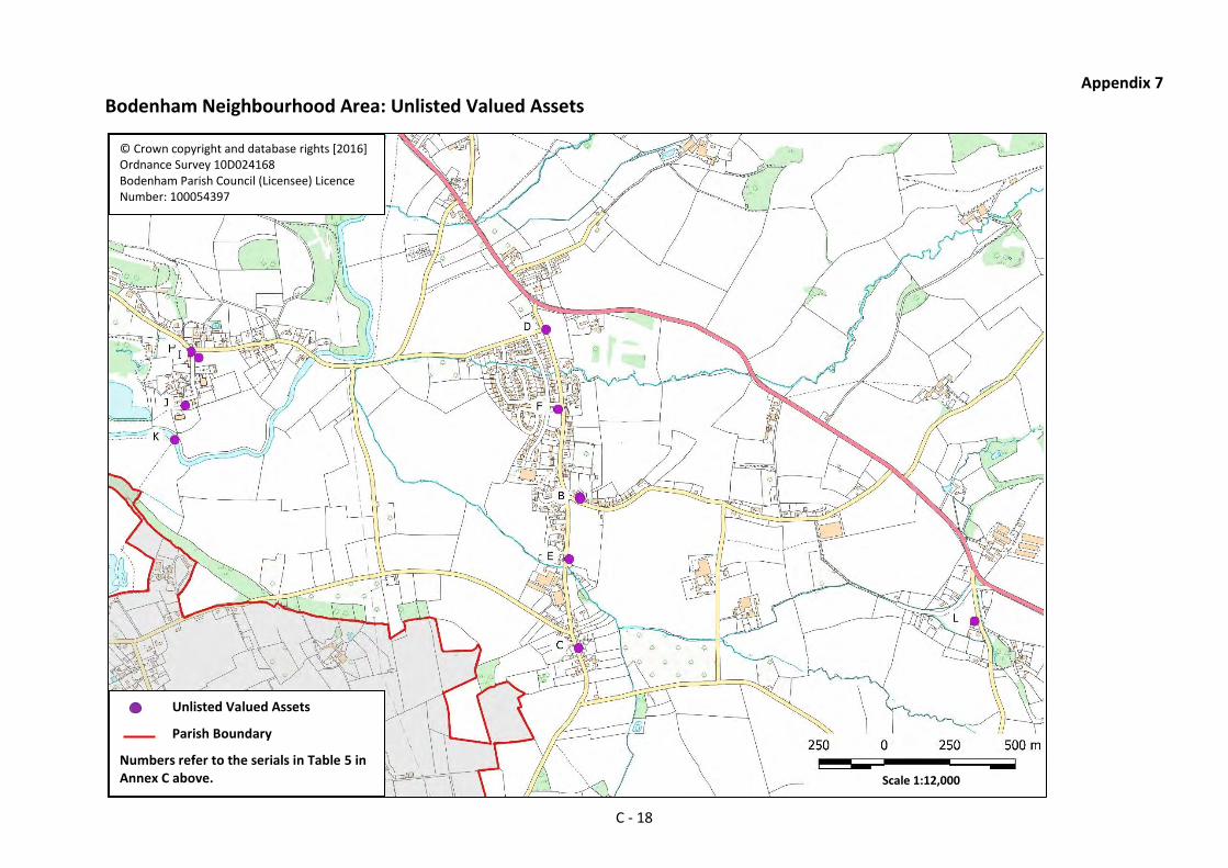
Appendix 7
Bodenham Neighbourhood Area: Unlisted Valued Assets
© Crown copyright and database rights [2016] Ordnance Survey 10D024168 Bodenham Parish Council (Licensee) Licence Number: 100054397
Scale 1:12,000
Unlisted Valued Assets
Parish Boundary
Numbers refer to the serials in Table 5 in Annex C above.
C - 18

Appendix 8
Bodenham Neighbourhood Area – Public Rights of Way
© Crown copyright and database rights [2016] Ordnance Survey 10D024168 Bodenham Parish Council (Licensee) Licence Number: 100054397
C - 19
Footpaths
Bridleways
Parish Boundary Scale 1:31,000

Annex D
Environment Agency River Flood Map and Bodenham Neighbourhood Area
© Environment Agency copyright and/or database rights 2015. All rights reserved. © Crown copyright and database rights
2004 Ordnance Survey 100024198.
Crown copyright and database rights [2016] 10D024168 Bodenham Parish Council (Licensee) Licence Number
100054397
Legend
Main River
Flood Zone 3 (1 in 100 and greater) Flood Zone 2 (1 in 1000 – 1 in 100) Parish Boundary
D - 1

Annex E Environment Agency Surface Water Flood Map andBodenham Neighbourhood Area
© Environment Agency copyright and database rights 2014. © Ordnance Survey Crown copyright. All rights reserved. Environment Agency, 100026380. Contains Royal Mail data © Royal Mail copyright and database right 2014. Bodenham Parish Council (Licensee) Licence Number: 100054397
Legend – Surface Water Flood Risk
High (1 in 30) Medium (1 in 100 – 1 in 30) Low (1 in 1000 – 1 in 100) Very Low (<1 in 1000) Parish Boundary
E - 1

Annex F
Housing Growth in the Plan Period
Table 1 - Windfall (including Commitments) Development in Recent Years (as at November 2017)
Ser Number of
Houses Development Remarks (21) Location
(Current Status) (Note 1)
(a) (b) (c) (d) (e)
From 2000 to 2011
1. 1 Dwelling at Laxton Barn, adjacent to Stonehouse, The Moor, Bodenham Moor HR1 3HS(C1125)
Conversion of redundant barn to granny annexe and living accommodation. DCN010185/F 19 Dec 2001
Bodenham Moor (Completed)
2. 3 Houses in Sycamore Close, Bodenham Moor (off C1125)
Demolition of existing bungalow and erection of 3 no. dwellings with garages. DCN013437/F 18 Feb 2002
Bodenham Moor (Completed)
3. 1 Duncton House, Land between Beltaine House and Littlefield, The Moor, Bodenham Moor HR1 3HT (C1125)
Construction of one dwelling plus garage and formation of layby access. DCN031123/F 22 Oct 2003
Bodenham Moor (Completed)
4. 1 Dwelling adjacent to Maundfield House in Chapel Lane, Bodenham Moor HR1 3HY (C1114)
Conversion of Old Smithy into residential dwelling. DCN040858/F 6 Jul 2004
Bodenham Moor (Completed)
5. 2 Border Oak houses adjacent to West Bay on The Moor, Bodenham Moor HR1 3HT (C1125)
Proposed erection of two dwellings (Willowherb and Pearmain) with garages and formation of new vehicular access. DCN051610/F 20 Jul 2005
Bodenham Moor (Completed)
21. Developments are listed in chronological order according to the Decision Date shown against the planning application number in Column (d).
F - 1

Ser Number of
Houses Development Remarks (21) Location
(Current Status) (Note 1)
(a) (b) (c) (d) (e)
6. 2 Houses North-West of Stonehouse in Dunfield Lane (aka Gravel Lane), Bodenham Moor HR1 3HS (U94021)
Proposed 2 No. three bedroom dwellings (Dunfield House and The Hawthornes). NC053327/F 4 Jan 2006
Bodenham Moor (Completed)
7. 1 Dwelling at Pool Head House, Chapel Lane, Bodenham Moor HR1 3HP (C1114)
Proposed replacement dwelling, with self-contained annex, garage and replacement outbuilding. DCN063453/F 11 Dec 2006
Open Countryside (Completed)
8. 4 Houses on former Berrington House site in Chapel Lane, Bodenham Moor HR1 3HR (C1114)
Proposed 2 No. detached dwellings at plots 2 & 3 with integral garages. DCN071177/F 5 Jun 2007
Proposed detached dwelling to plot 1 DCN070958/F 5 Jun 2007
Proposed erection of four dwellings DCN062669/RM 21 Sep 2006
Bodenham Moor (Completed)
9. 5 Dwellings at Dudales Hope Farm, Bodenham HR1 3HY
Proposed conversion of redundant barns into 5 No. dwellings. DCN072936/F 14 Nov 2007
Open Countryside (Work started)
10. 1 Traveller residential accommodation at Pool Head Orchard, Chapel Lane (C1114)
Retrospective application for renewal of temporary permission for a site for one travelling family including two residential static caravans, toilet block, day room, shed and boundary wall. Permanent consent granted. DCN081725/F 12 Nov 2009.
Open Countryside (Completed)
11. 21 Sub-Total for 2000 – 2010
F - 2

Ser Number of
Houses Development Remarks (21) Location
(Current Status) (Note 1)
(a) (b) (c) (d) (e)
From 2011 (Start of the Plan Period) to the Present
12. 2 Dwellings adjacent to 10 Caldervale, Woodhouse Lane, Bodenham Moor HR1 3LB (U94016)
Proposed two single storey dwellings. Affordable dwellings (Marches Housing). N102973/F 24 Mar 2011
Bodenham Moor (Note 2)
13. 1 Dwelling at Rowberry Court, Rowberry Lane HR1 3JD (U94018)
Adaptation of agricultural building. Lawful development certificate for an existing use of building as a dwelling house (CLUED). N123358/U 14 Feb 2013
Open Countryside (Note 2)
14. 3 Barn conversions at Maund Court (off A417)
Proposed conversion of redundant stone barn to form 3 No. dwellings for private rented accommodation plus associated vehicle parking, cycle storage and landscaping. N130167/F 24 May 2013
Open Countryside (Note 3)
15. 1 Dwelling at Broxmere, Maund Bryan HR1 3JB
Proposed removal of condition 4 of planning permission DCN2005/2341/F (3 no. holiday chalets) - to allow holiday chalets to become a self-contained planning unit separate from the main dwelling. P141158/F 5 Jun 2014
Open Countryside (Completed)
16. 1 Dwelling at Gritt Farm, Chapel Lane (C1114)
Proposed agricultural workers dwelling with garage and new vehicular access. P141352/F 20 Jun 2014
Open Countryside
(Note 2)
F - 3

Ser Number of
Houses Development Remarks (21) Location
(Current Status) (Note 1)
(a) (b) (c) (d) (e)
17. 1 Dwelling at Pump Cottage, Bodenham HR1 3JX (C1121)
Proposed dwelling and ancillary garage. P150103/F 17 Mar 2015 P170121/F 1 Mar 2017
Bodenham (Under construction)
18. 2 Dwellings at the Grain Store, Stonehouse Farm, Hollybush Lane, HR1 3HZ
Proposed conversion of agricultural building to create two dwellings. Consent under GPDO P150341/PA4 27 Mar 2015 P151254/PA4 5 Jun 2015
Open Countryside (Under construction)
19. 1 Dwelling adjacent to the Pigeon House, Bodenham HR1 3JX (C1121)
Proposed construction of a new self-build dwelling and new access. P151660/F 13 Aug 2015
Bodenham (Not yet started)
20. 40 Dwellings in Bell Homes ‘England’s Field’ development opposite England’s Gate Inn, Bodenham Moor (C1125)
Reserved Matters for construction of 40 new dwellings with associated infrastructure. P151055/RM 26 Oct 2015
Bodenham Moor (12 Under
construction 28 Completed)
21. 1 Conversion of Annexe, Bodenham Manor HR1 3JS (C1121)
Completion of domestic change of use/conversion of annexe, including construction of detached garage. The proposal includes the completion of the domestic conversion of part of the first floor, and the change of use on the un-rated ground floor and the shower and changing facilities on the first floor into residential accommodation. P152989/F 14 Dec 2015
Bodenham (Completed)
22. 5 Houses adjacent to England’s Gate Inn, Bodenham Moor
Proposed residential development of up to five dwellings with associated vehicle access. P151675/O 2 Feb 2016
Bodenham Moor (Not yet started)
F - 4

Ser Number of
Houses Development Remarks (21) Location
(Current Status) (Note 1)
(a) (b) (c) (d) (e)
23. 1 Dwelling at Bodenham Manor HR1 3JS (C1121)
Proposed erection of new 5 no. bedroom house and detached garage to replace Bodenham Manor (following demolition via separate application ref: 151607). P153090/F 16 Mar 2016
Bodenham (Under construction)
24. 3 Houses adjacent to Stoneleigh, Bodenham Moor HR1 3HS (C1125)
Proposed erection of 3 no. detached residential dwellings with garages. P151651/F 17 Jun 2016
Bodenham Moor (1 not yet started
2 Under Construction)
25. 2 Dwellings on Land at Wynmoor, Bodenham Moor (C1125)
Proposed reserved matters following outline approval 152415 (Proposed site for 2 dwellings). P162438/RM 17 Oct 2016
Bodenham Moor (Under construction)
26. 3 Old School Buildings, Bodenham Manor (C1121)
Demolition of former school buildings and erection of three detached dwellings. P162506/F 4 Nov 2016
Bodenham (Not yet started)
27. 2 Dwellings on Land East of Bodenham Manor between Bodenham Cottages and The Orchard, Bodenham
2 no. 4 bedroom dwellings with attached/detached garages, including the change of use of agricultural land to residential, and rerouting of a stoned access track. P163313/F 12 Jan 2017
Bodenham (Not yet started)
28. 1 Dwelling on Land adjacent to 2, Railway Cottages, Dinmore
CLEUD DCN082455/U granted on 19 November 2008 “for the siting of a caravan for recreational purposes and overnight accommodation”. Dwelling subsequently built on the site and permanently occupied in 2012.
Open Countryside (Note 2)
29. 70 Sub-Total 2011 to date
F - 5

Ser Number of
Houses Development Remarks (21) Location
(Current Status) (Note 1)
(a) (b) (c) (d) (e)
30. 91 Total (2000 to date)
Notes:
1. Status as at November 2017 as observed on site. 2. Completed – subject to confirmation in Herefordshire Council’s 2018 Five Year Housing Supply Statement. 3. Under construction - subject to confirmation in Herefordshire Council’s 2018 Five Year Housing Supply Statement. 4. The locations of post-2011 commitments within the Parish are shown in the overview map in Appendix 1 to this Annex. The locations of those sited within the Bodenham Moor and Bodenham settlement boundaries are also shown in more detail in Annexes G and H.
Table 2 – Summary of Housing Commitments and Completions Shown in Table 1
Ser. Period Location Not Yet
Started
Under
Construction
Completed Totals
(a) (b) (c) (d) (e) (f) (g)
1. 2000 -
2010
Bodenham Moor 14 14
2. Bodenham
3. Open Countryside 5 2 7
4. Sub-Totals 5 16 21
5. 2011 -
Date
Bodenham Moor 6 16 30 52
6. Bodenham 6 2 1 9
7. Open Countryside 5 4 9
8. Sub-Totals 12 23 35 70
9. Totals 12 28 51 91
F - 6

Table 3 - Housing Growth Data
Housing Supply Calculations Total
A. Total housing stock in the Parish as at October 2015. (22) 485
B. Total housing stock in the Bodenham Moor and Bodenham settlements as at October 2015. (23)
311
C. Local Plan minimum 15% requirement for new houses in the Parish in the Plan Period [A x 15%].
72
D. Completions and commitments from 2011 to date (see Table 1 above). 70
E. Additional new houses required to meet the minimum 15% requirement [C-D]
2
F. Number of houses built/ committed since 2000 (i.e. over the past 16 years), excluding the major development opposite England’s Gate Inn (see Table 1 above).
51
G. Assessment of potential future windfalls from 2017 to the end of the Plan Period (i.e. over the next 14 years).
14
Appendix:
1. Bodenham Neighbourhood Area Commitments (2011-2016) – Overview.
22. The Local Plan assesses the total housing stock in the Neighbourhood Area as 485 dwellings, as at 16 October 2015 when the Core Strategy was adopted by Herefordshire Council. This gives the 15% minimum requirement for new housing as 72. A physical count and mapping of all dwellings in the Neighbourhood Area at the same date produced a total of 474 dwellings which would result in a minimum requirement of 71. The NDP works to the higher figure. 23. As at October 2015 there were 242 houses in Bodenham Moor and 69 houses in Bodenham. The size ratio of the two settlements is therefore very approximately 4:1.
F - 7

F 5
Appendix 1
Bodenham Neighbourhood Area Commitments (2011-2016) – Overview
© Crown copyright and database rights [2016] Ordnance Survey 10D024168 Bodenham Parish Council (Licensee) Licence Number: 100054397
Commitments
Settlement Boundaries
Parish Boundary
Numbers in [ ] refer to the serials in Table 1 in Annex F above. More detailed maps are at Annexes G and H. -
1:23,000

Annex G
Bodenham Moor Settlement Boundary with Commitments since 2011
© Crown copyright and database rights [2016] Ordnance Survey 10D024168 Bodenham Parish Council (Licensee) Licence Number: 100054397
SCALE 1:6,500
Commitments since 2011
Settlement Boundary
Parish Boundary
Numbers in [ ] refer to the serials in Table 1 in Annex F.
G - 1

Annex H
Bodenham Settlement Boundary with Commitments since 2011
© Crown copyright and database rights [2016] Ordnance Survey 10D024168 Bodenham Parish Council (Licensee) Licence Number: 100054397
Commitments since 2011
Settlement Boundary
Numbers in [ ] refer to the serials in Table 1 in Annex F.
Scale 1:2,500
H - 1

I 1
11
Annex I
Bodenham Neighbourhood Area - Important Public Views
© Crown copyright and database rights [2016] Ordnance Survey 10D024168 Bodenham Parish Council (Licensee) Licence Number: 100054397
1
2
7
3
10
5
4
6
8
-
General viewpoint and direction of view with number of the related description in the table below.
3

View number
Description
1. From PROW BM16 (runs north/south parallel to Bowley Lane (C1113)) across the River Lugg, Bodenham Loop and Bunhill promontory with the Ashgrove Wood and Cheat Hill ridgelines as backdrop. Distant vista of Skirrid, Garway and Orcop Hills.
2. From the A417 across the River Lugg flood plain to Bunhill and St. Michael’s Church and south-west to the backdrop of the ‘God Almighty’ ridge line.
3. From Bodenham Bridge across the River Lugg flood plain towards the Ashgrove ridgeline.
4. From Millcroft Road (C1121) southward across mixed orchard/arable farmland and flood plain pasture to Venn’s Wood and Cheat Hill escarpment and northward across the floodplain and arable either side of Ketch Lane (C1113) towards Dorlas Coppice and the arable slopes either side of Bowley Lane.
5. From the Siward James Centre and edge of The Moor settlement along the River Lugg floodplain and the wooded slopes of Dinmore Hill.
6. From the C1125 running along The Moor north-east towards the elevated patchwork of fields at Dudale’s Hope and Houghton Court Farms.
7. From Hollybush Lane (C1114) over The Moor settlement and River Lugg floodplain towards Bodenham Lake Nature Reserve and the wooded slopes of Dinmore Woods beyond.
8. View to the north before entering Bodenham Moor along the C1125 across the River Lugg floodplain towards the elevated partly wooded Broadfield Estate.
9. From Ashgrove Wood north-east across floodplain meadow towards St. Michael’s Church, Bodenham loop of the River Lugg and Bunhill backdrop.
10. From Westfield Wood on the C1121 across Bodenham Lake Nature Reserve and the River Lugg valley and, in the south-east, to St. Michael’s Church and the Ashgrove Wood ridgeline backdrop.
I - 2